Article

Identification, Characterization, and Deposit Model of Calcite Mineralization in the Middle Atlas Belts, Morocco

by
Abdelkhiar Ait Ali
1,*,
Mohammed Charroud
1,
Jaouad Choukrad
1,
Youssef Ouahzizi
1,
Hicham Si Mhamdi
2,
Nacir El Moutaouakkil
3,
Naoufal Saoud
1 and
Abdellah Mechaqrane
1
1
Intelligent Systems, Georesources and Renewable Energies Laboratory, Faculty of Sciences and Techniques of Fez, Sidi Mohamed Ben Abdellah University, P.O. Box 2202, Fez 28810, Morocco
2
Laboratory of Applied Geology, Department of Geosciences, Faculty of Sciences and Techniques of Errachidia, Moulay Ismail University, Meknes 50050, Morocco
3
Laboratory of Géosciences, Water and Environment. Department of Earth Sciences, Faculty of Sciences, University Mohamed V Rabat, Rabat 10090, Morocco
*
Author to whom correspondence should be addressed.
Geosciences 2024, 14(6), 154; https://doi.org/10.3390/geosciences14060154
Submission received: 25 April 2024 / Revised: 24 May 2024 / Accepted: 31 May 2024 / Published: 6 June 2024

Abstract

:
The Middle Atlas hosts calcite veins of considerable economic value, being found in the Mahdi and Bou Naceur ridges in the eastern part of the Moroccan Middle Atlas. In this study, we aim to identify the fundamental factors controlling mineralization, which could be essential for the exploration of calcite minerals. Jurassic dolomites and limestones host calcite deposits. Mineralization is controlled by the NE-SW sinistral fault system of the Mahdi Ridge as well as by the NW-SE dextral fault system of the Bou Naceur Ridge. These veins exhibit a Riedel shear system. The edges of the veins display different textures, such as banded and brecciated calcite. At the heart of the veins are deposits of massive, automorphic, pure crystalline calcite. Geochemical analyses revealed carbonate rock dissolution and carbonate fluid infiltration, indicating the presence of a low-temperature hydrothermal system. These mineralizations are a response to the evolution of the geodynamic uplift of the Middle Atlas during the Neogene, which occurred during the Alpine orogeny.

1. Introduction

The exploration of minerals and valuable rocks, such as carbonates and calcite, is increasingly being carried out in seldom-prospected regions. Calcite forms in sedimentary rocks (such as limestone and dolomite) [1] and metamorphic rocks (such as marble) [2]. The importance of calcite as an economically important mineral is reflected in its irreplaceable use in the paper, plastics, paint, rubber, and adhesives industries [3,4]. It is also used in the chemical, sugar, glass, alkaline, leather, and tanning industries [5].
The results of a number of tectonic and metallogenic studies have shown that opening faults serve as conduits for fluid flow and the emplacement of economically important ore deposits [6,7,8,9,10,11,12].
Calcite veins are good markers for the characterization of hydrothermal conditions and fluid migrations during the evolution of sedimentary basins [7,13,14,15,16].
The Moroccan Atlas range contains mineable calcite deposits in outcrops in the Middle Atlas. The fact that they are close to major faults makes them the perfect framework for deciphering the evolution of fluids and the mechanisms that led to the deposition of this calcite ore.

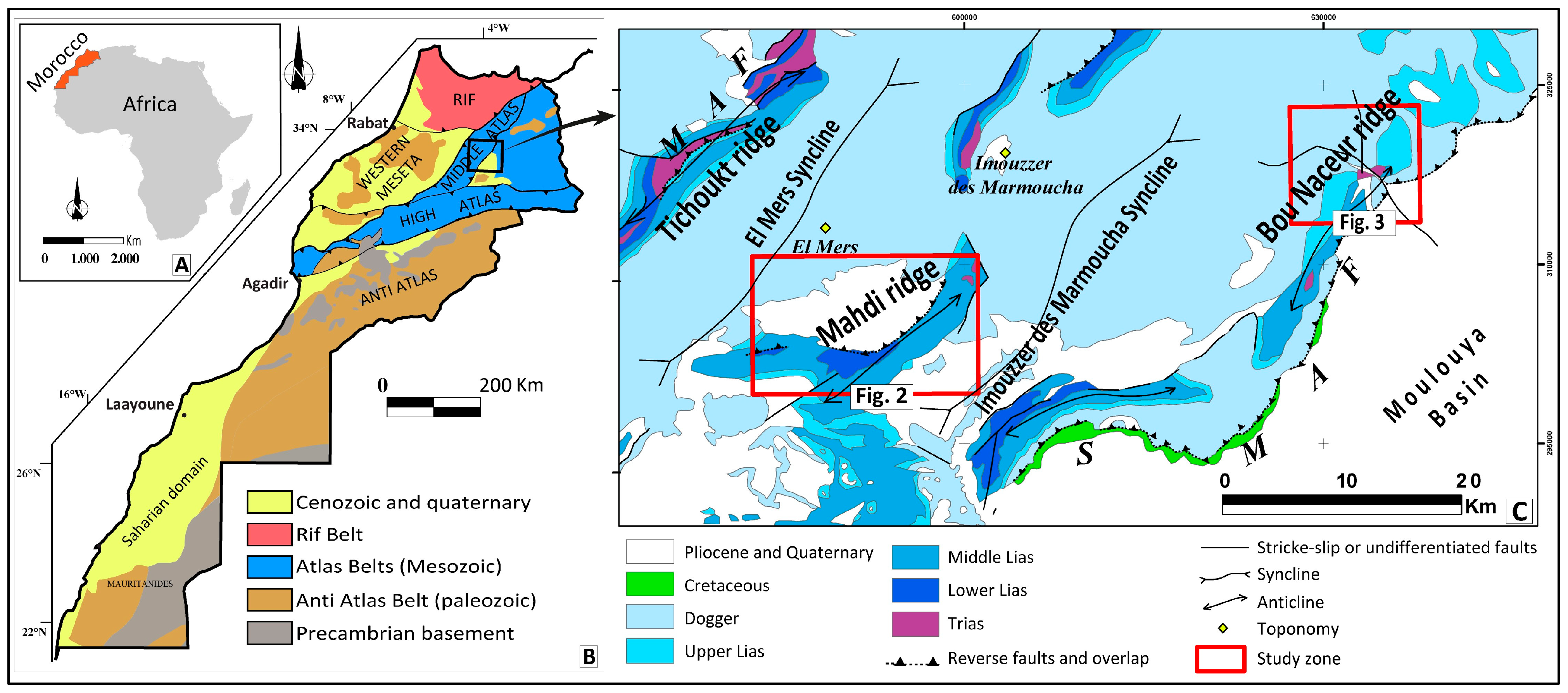
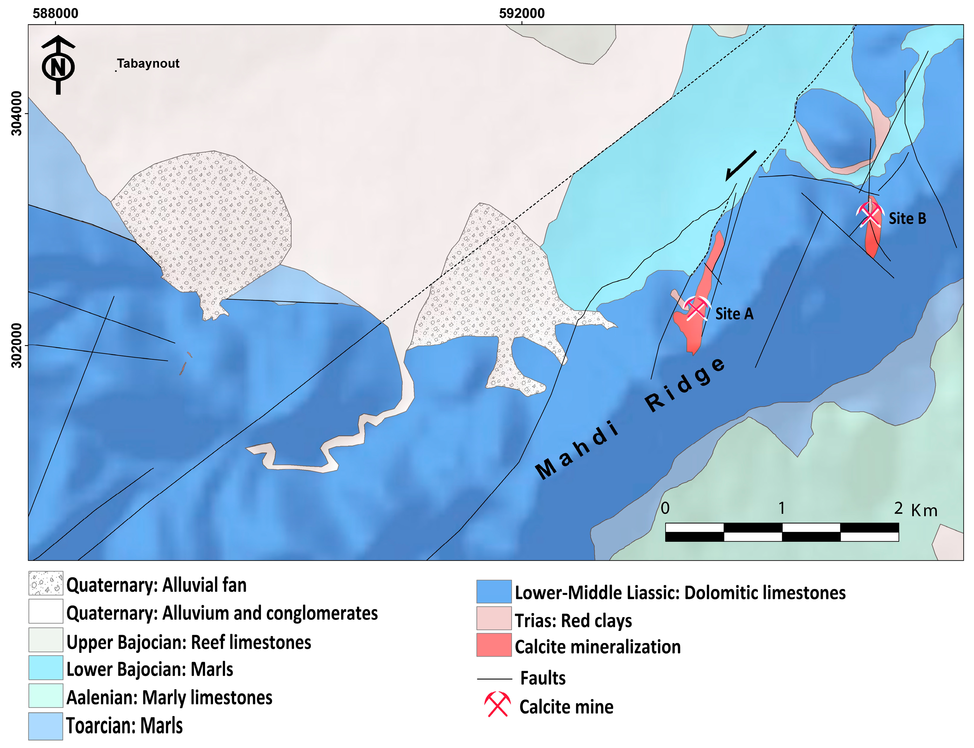
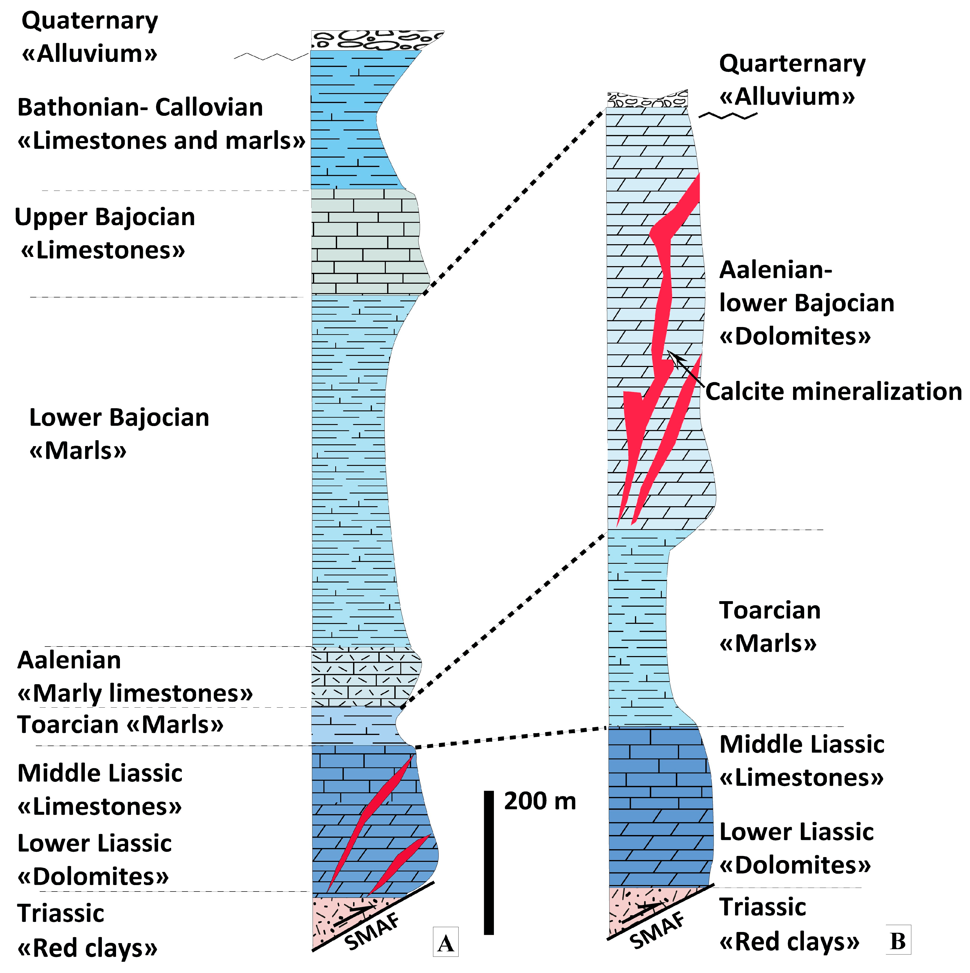
2. Geological Setting

The Middle Atlas is the northern part of the Moroccan Atlasic belts, which consist of the High Atlas and Middle Atlas (Figure 1A,B). The Middle Atlas has an NE-SW orientation and is bounded by the Neogene and Quaternary basins, the High Atlas chain to the south, the Rif chain to the north, and the Western Meseta domain to the west (Figure 1B).
The Middle Atlas belt is an intraplate chain structured into Liasic carbonate anticlines and dogger marl and limestone synclines [17,18,19,20,21,22,23,24,25]. In the eastern part of the folded Middle Atlas, there are several faulted anticlinal ripples that match the Southern Middle Atlas Fault zone (SMAF, Figure 1C), which separates the Middle Atlas range from the Moulouya basin [18,26,27,28,29,30]. This major E-NE-trending fault has a sinistral reverse component along faults [29,31,32].
The Mahdi and Bou Naceur ridges, in the eastern part of the folded Middle Atlas, host calcite deposits (Figure 1C). Both ridges are faulted anticlines located on the southern Middle Atlas fault zone (SMAF, Figure 1C).
Figure 1. (A) Morocco’s location, (B) simplified structural maps of Morocco and location of the study area, and (C) simplified geological map of the eastern part of the Middle Atlas taken from a 1/1,000,000 geological map of Morocco [33] (SMAF: South Middle Atlas Fault; MAF: Middle Atlas Fault).
Geosciences 14 00154 g001
At an altitude of 2100 m, two NE-SW-trending faulted anticlines, Serghina and Mahdi, are separated by a dextral fault at the Bou Qazdir peak. This fault borders an outcropping of the Triassic red clays and siltstones (Figure 2). Lower and Middle Lias carbonate formations are represented by Tamkant dolomites, dolomitic limestones, and Carixian–Domerian ammonite limestones [18,34,35,36,37]. This is overlain by red Toarcian marl formations known as the Mibladen Formation. [28,29,36,38] and marly limestone of the Aalenian named the Amane Illila Formation [37,39,40]. The Bajocian is represented by thick sequences of gray marls and reefal limestones [17,28,34]. The Bathonian corresponds to the El Mers formation, which outcrops at the base of the section and consists of alternating marl and limestone [18,19].
Bou Naceur is the highest mountain in the Middle Atlas, with an altitude of 3326 m. It is a faulted anticline, bounded by the South Middle Atlas Fault and considered a type of frontal ramp [29]. The Triassic, Lower, and Middle Liassic formations of Bou Naceur Ridge are similar to the Mahdi Ridge. However, the Toarcian is thicker and corresponds to the Tirnest marls (200 m); they are overlain by limestones and dolomites known as the high plateau dolomites of Aalenian—lower Bajocian [19,29,32,34] (Figure 3).

3. Methodology

In order to identify and characterize the calcite of the Middle Atlas, a series of reconnaissance surveys of the geological strata in these areas was conducted, focusing on the formations hosting calcite mineralization at the Mahdi and Bou Naceur ridges. Lithostratigraphic logs were established, along with the corresponding mineralization. Geological mapping of the major structures hosting calcite mineralization was carried out, with a detailed representation of mineralization imbrications and the identification of the calcite families filling the structures. Structural measurements and surveys were conducted to define the tectonic regimes that led to the formation of the mineralized bodies and specify the geometries of the calcite mineralization. Paleostress reconstructions were obtained using Win-Tensor software (free of charges for non-commercial applications) [41,42,43,44]. The procedure used was based on the method of Angelier [45], and we determined the relationship with the carbonate host rock.
Twenty-five (25) samples were collected from different vein outcrops of different calcite units to identify and characterize the factors that led to the deposition of the calcite deposits. Six (6) representative samples were subjected to petrographic analysis involving scanning electron microscopy (SEM) together with energy-dispersive X-ray (EDX) analysis (JSM-IT500HR) at Innovation City at the University of Fez and geochemical analysis using inductively coupled plasma mass spectrometry (ICP-MS) at ONHYM (National Office of Hydrocarbons and Mining) in Rabat.

4. Results

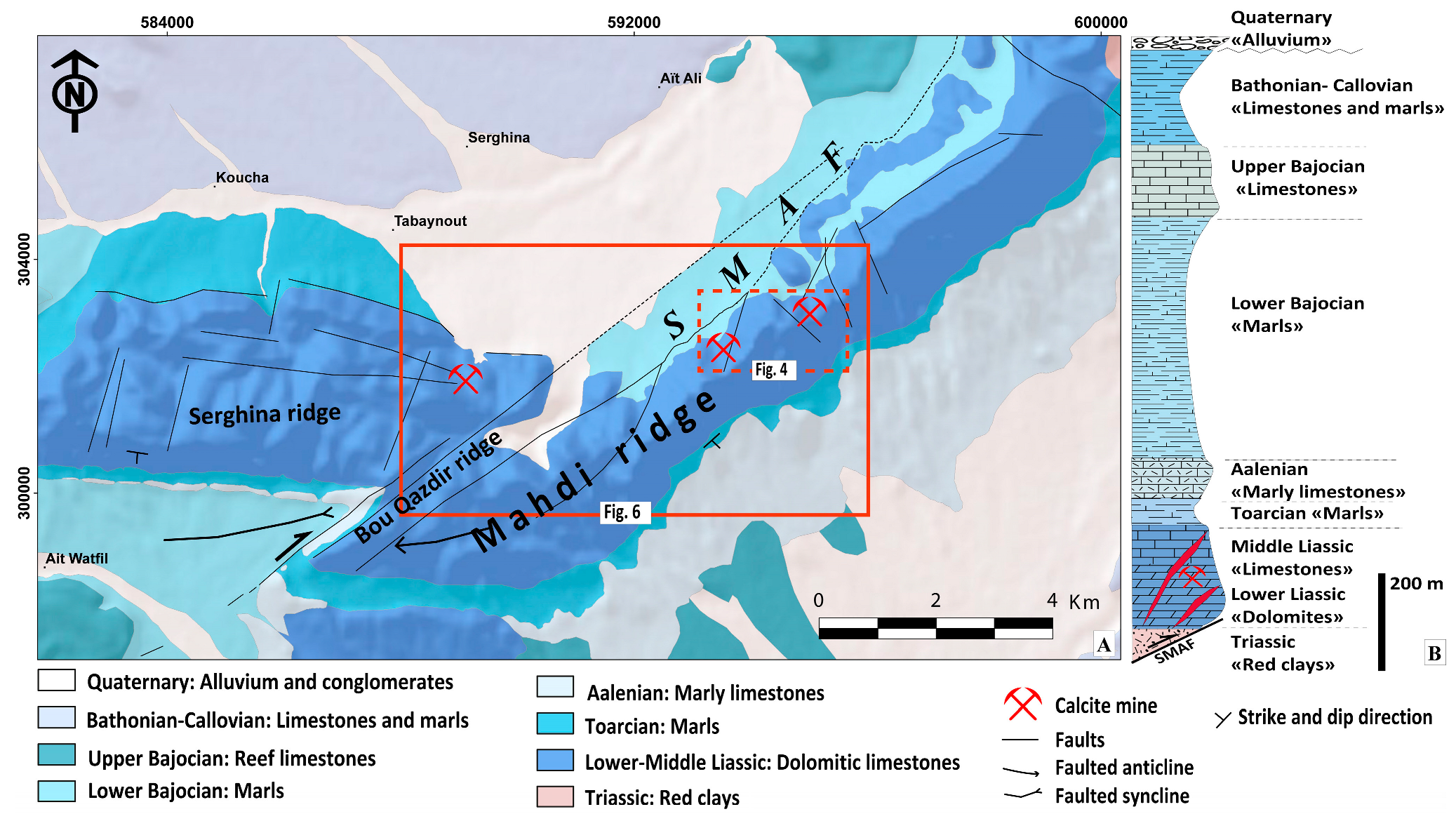
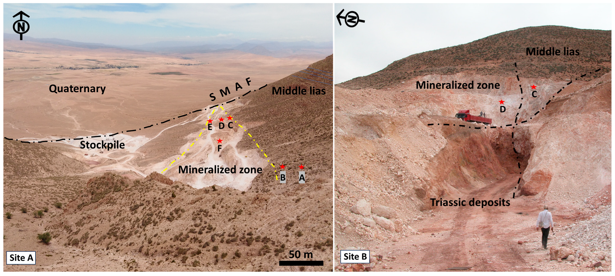
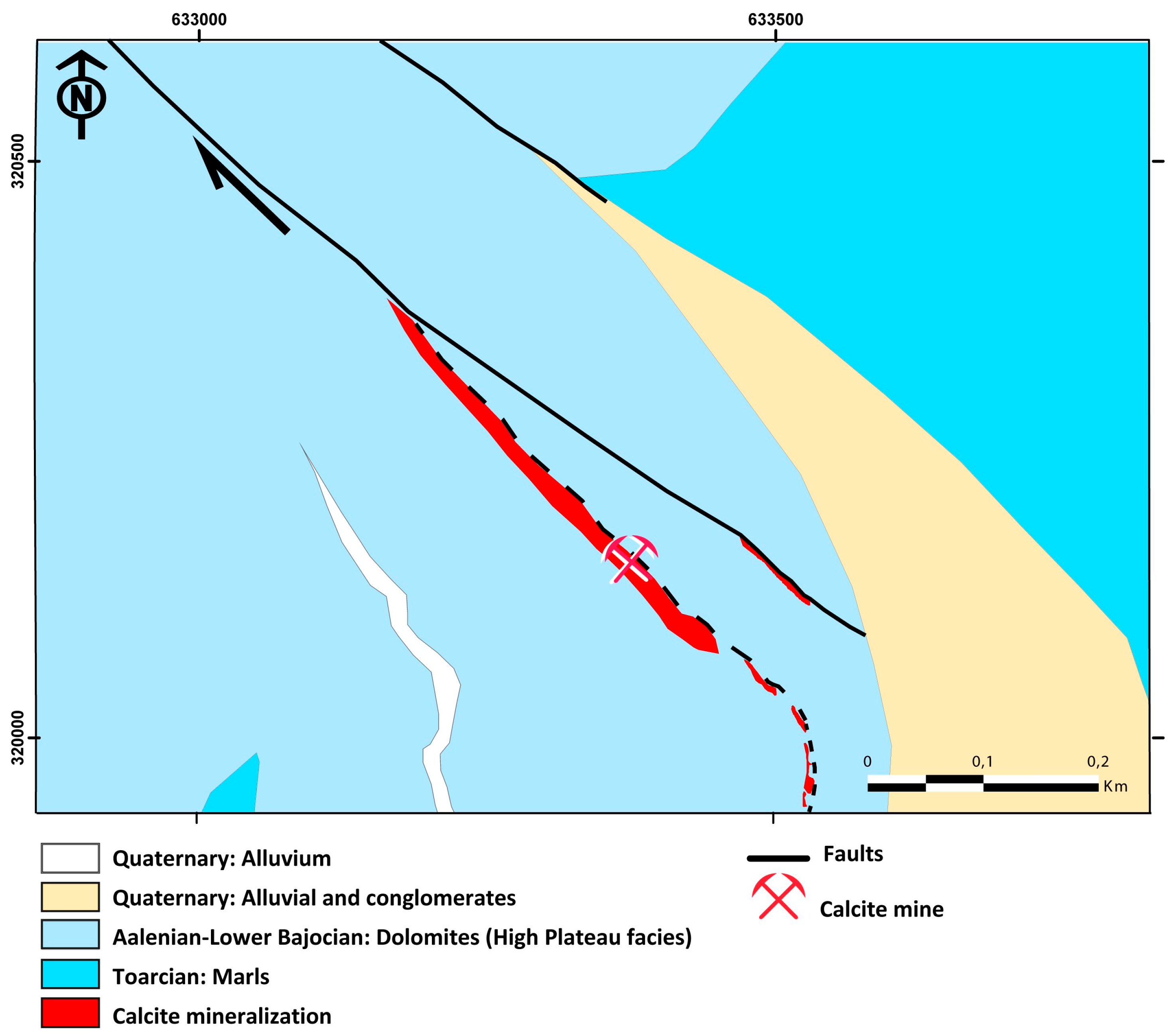
4.1. Mahdi Ridge: Calcite Vein System

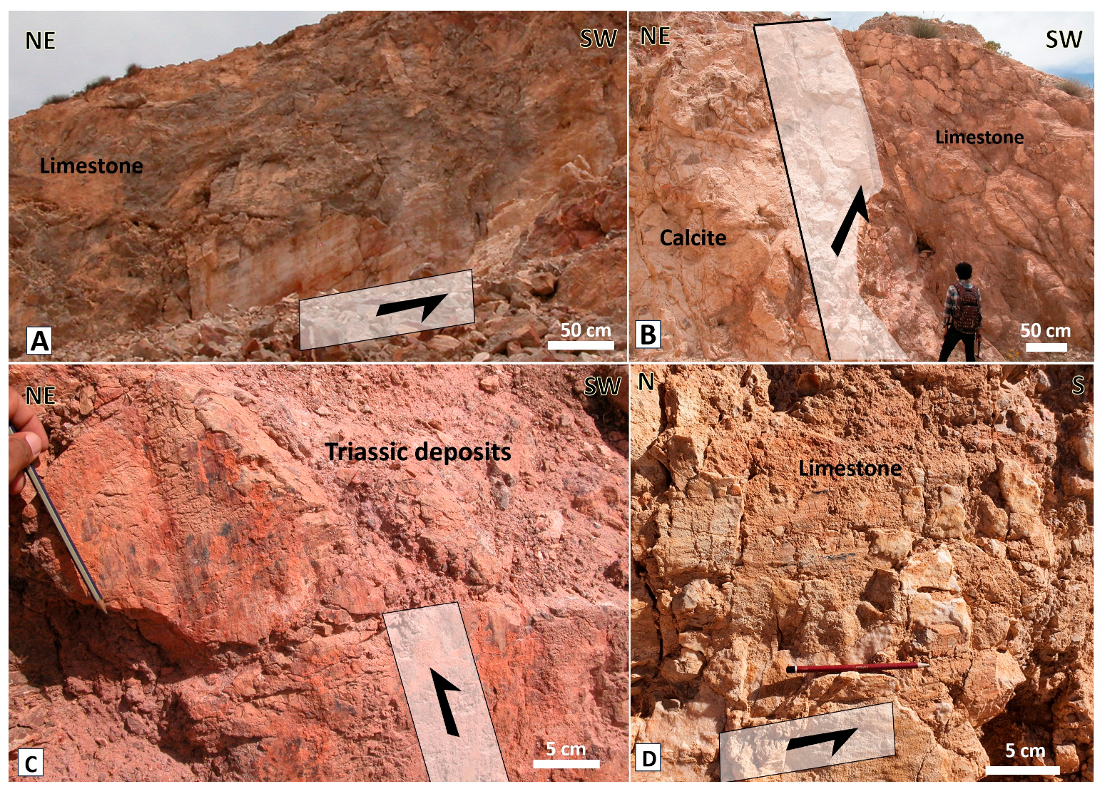
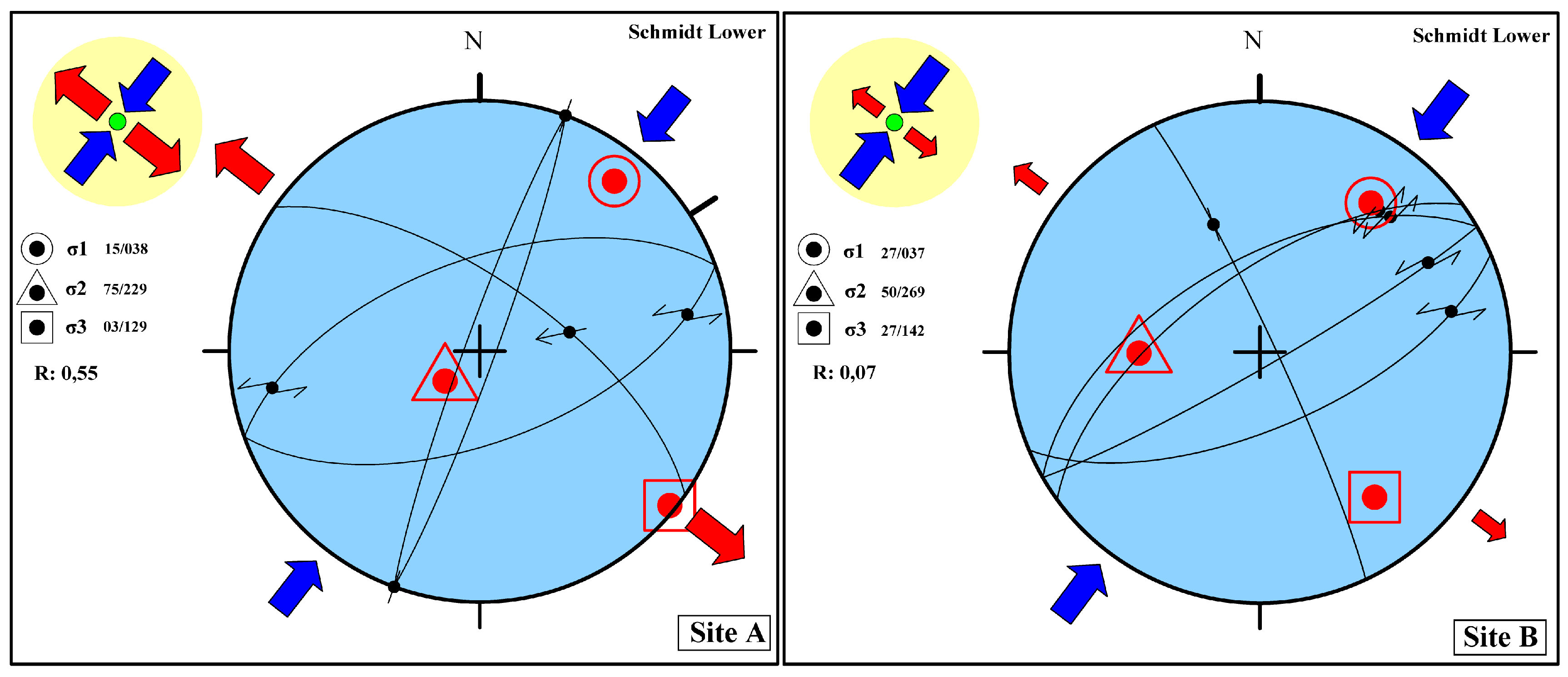
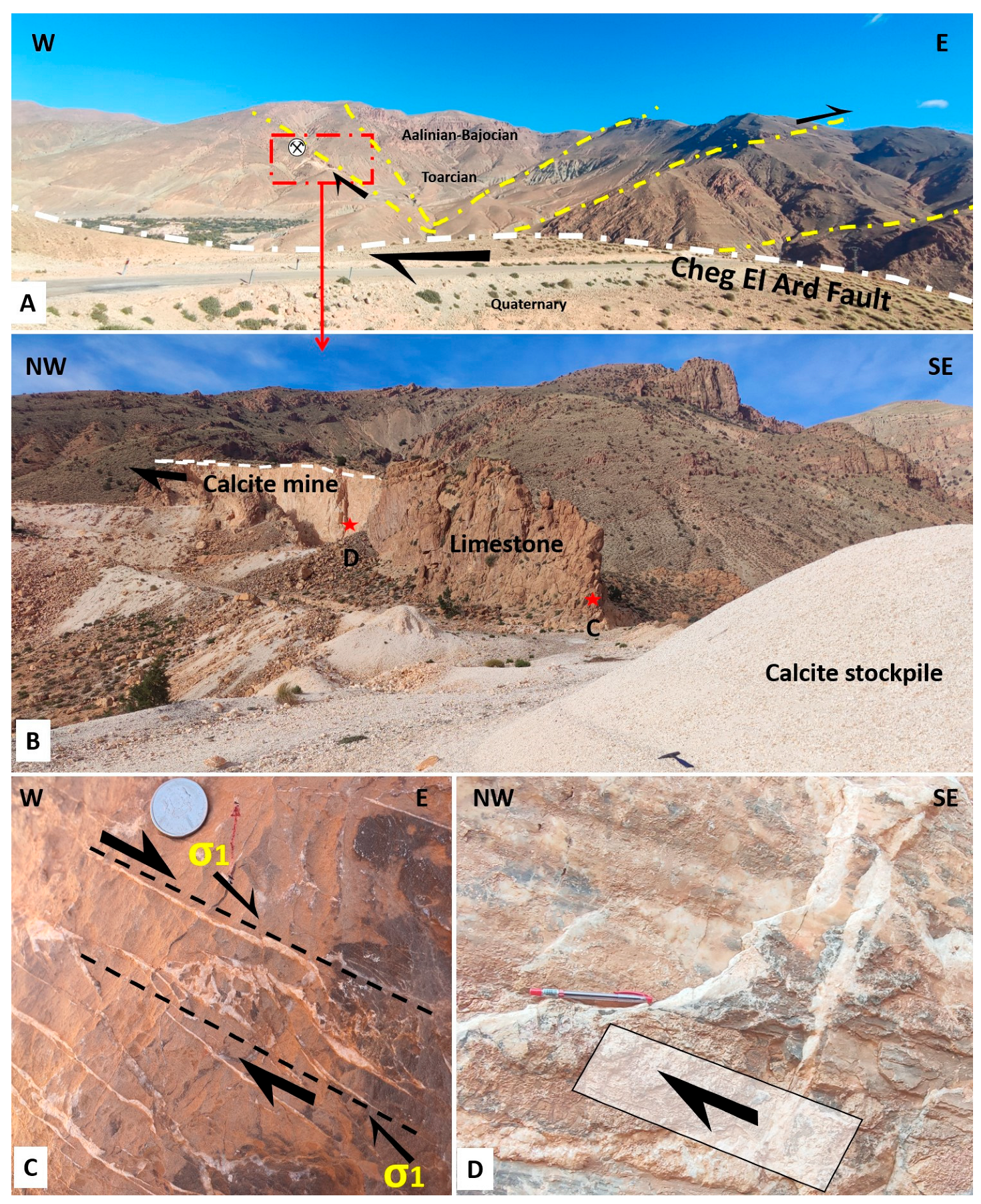
4.1.1. Structural Study

The geological mapping carried out in these calcite deposits of the Mahdi Ridge revealed that they exhibit a highly specific geometry, similar at various scales, ranging from centimetric veins to kilometric veins. They consist of anastomosing veinlets reflecting brittle tectonics affecting Liasic dolomites and limestone (Figure 4). Several systematic measurement campaigns have been carried out on all of the major faults mapped in the field (Figure 5). The direction of movement was determined by measuring the striations, slickensides, and grooves on the fault mirror.
Microstructural analysis at the mine scale of sites A and B (Figure 4 and Figure 5) of the Mahdi Ridge showed a parallel structure following the SMAF system. The structures are characterized by tectonic indicators showing a sinistral component of the SMAF at site A (Figure 4, Figure 5A,B and Figure 6), sinistral movement on the NE-SW fault (Figure 3, Figure 4D and Figure 5), and a reverse component on the NW-SE fault at site B (Figure 4, Figure 5C and Figure 6).
At site A, mineralization occurs in NNE-SSW-trending mega-extensional veins (Figure 4 and Figure 6). Fault mirror analysis showed that there are synthetic sinistral strike–slip tectoglyphs that move mostly from northeast to southwest (Figure 5A,B, and Figure 6).
At site B, there are sinistral NE-SW-trending strike–slip faults (Figure 5D and Figure 6) and reverse faults allowing NW-SE faults (Figure 5C and Figure 6).
The reconstruction of the paleostress shows that at the Mahdi Ridge, the NE-SW fault exhibits a horizontal strike–slip component with maximum horizontal stress (σ1) oriented NNE-SSW and extensional stress (σ3) also horizontally oriented NW-SE. The ratio R = (σ2 − σ3)/(σ1 − σ3) = 0.55 indicates that σ2 ≈ (σ1 + σ3)/2 at site A (Figure 6 and Figure 7—site A and Table 1). At site B, the constraint shows a sinistral strike–slip fault with a maximum stress (σ1) oriented NE-SW and extensional stress (σ3) oriented NW-SE. The ratio R = 0.07 (Figure 6 and Figure 7-site B and Table 1).
The faults trending from N40 to N70 display general sinistral movement of the South Middle Atlas fault, while the N120 and N140 faults are overthrust.

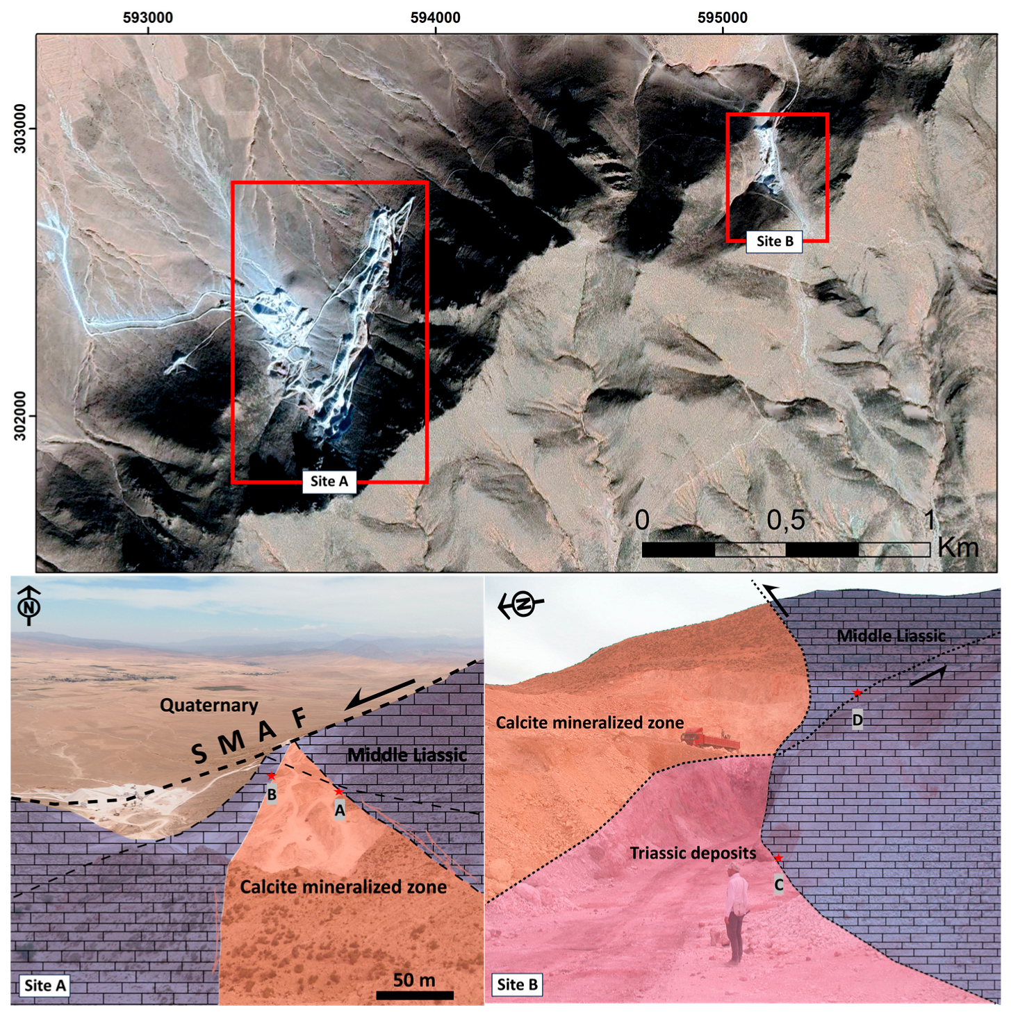
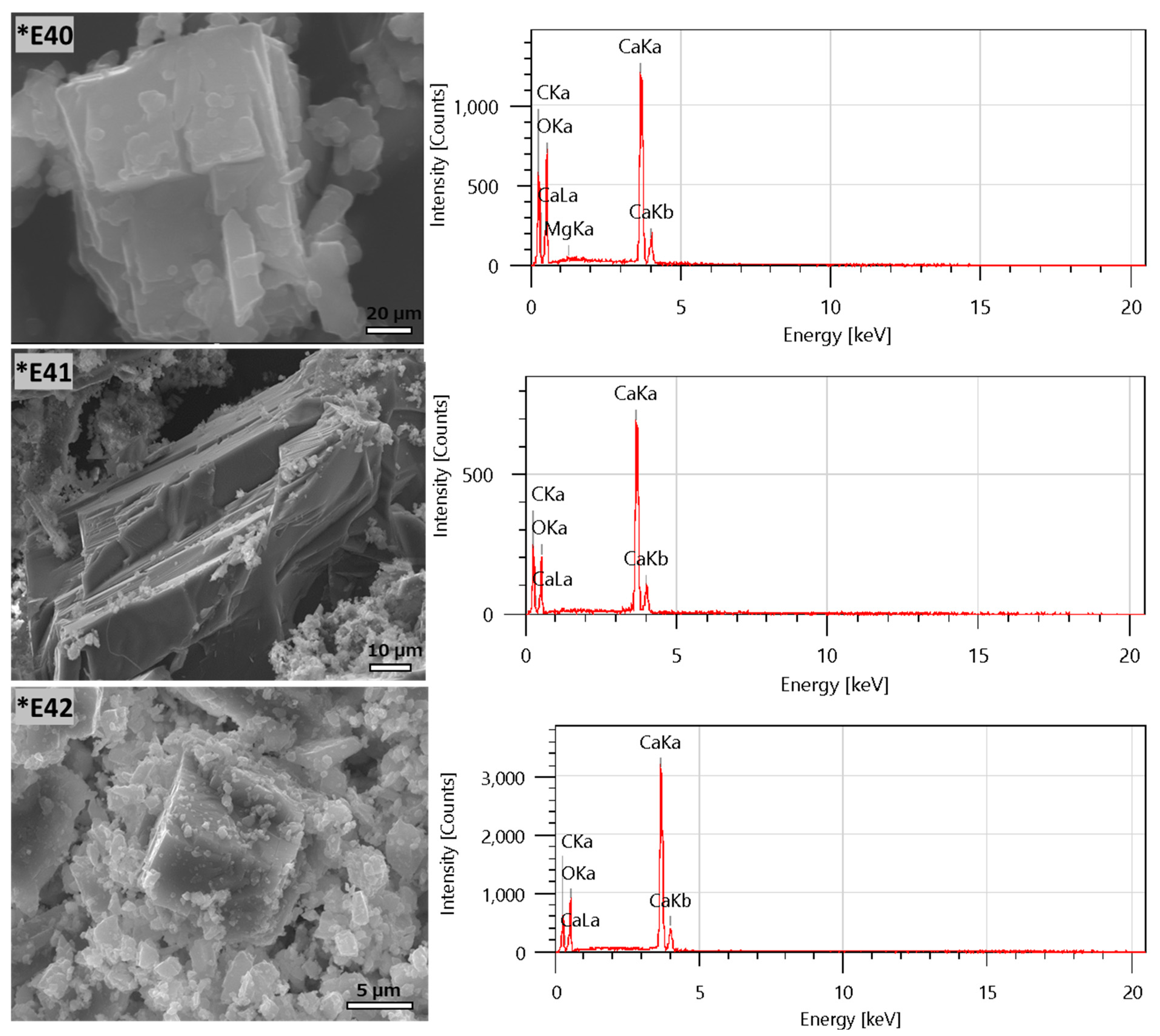
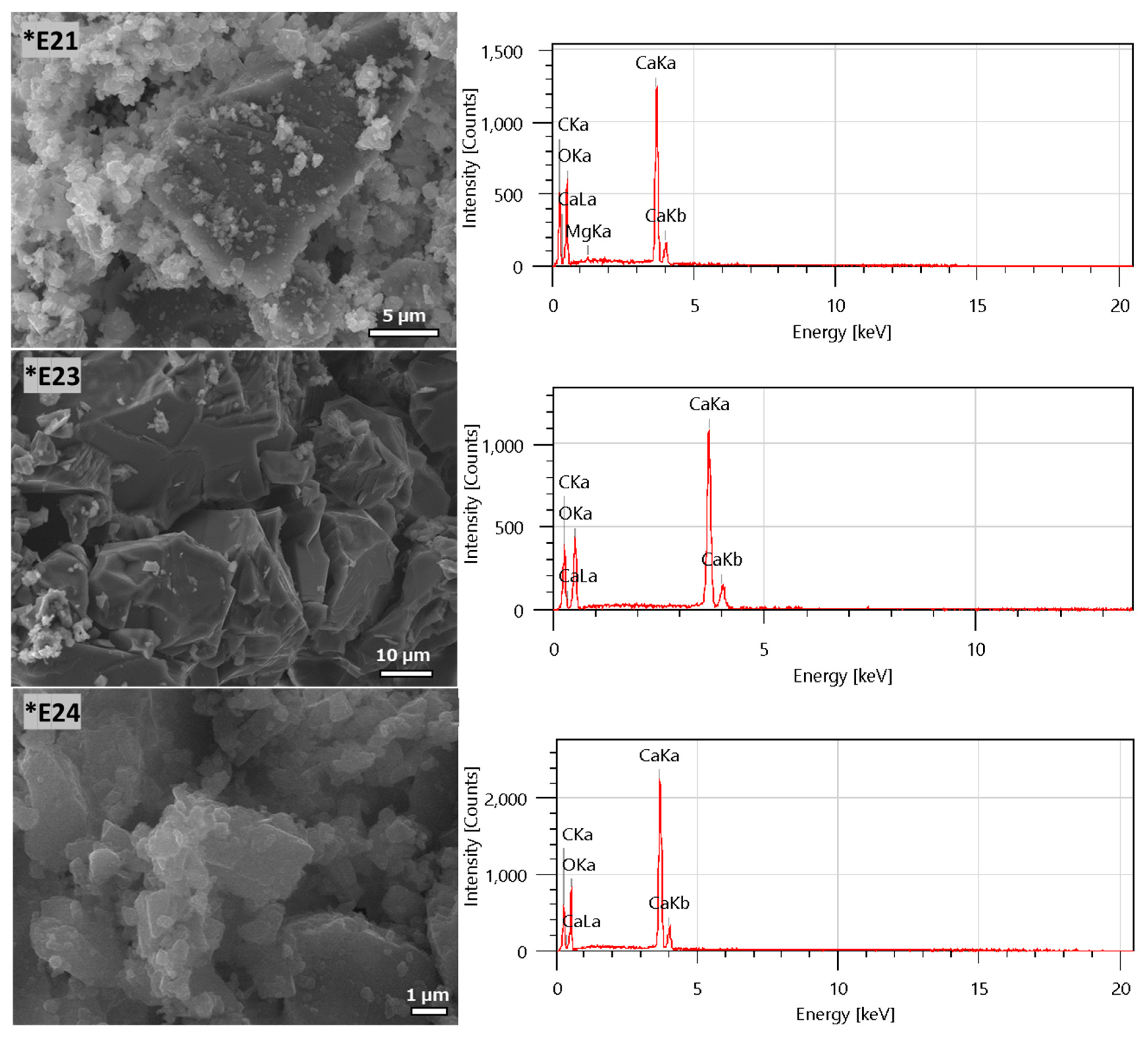
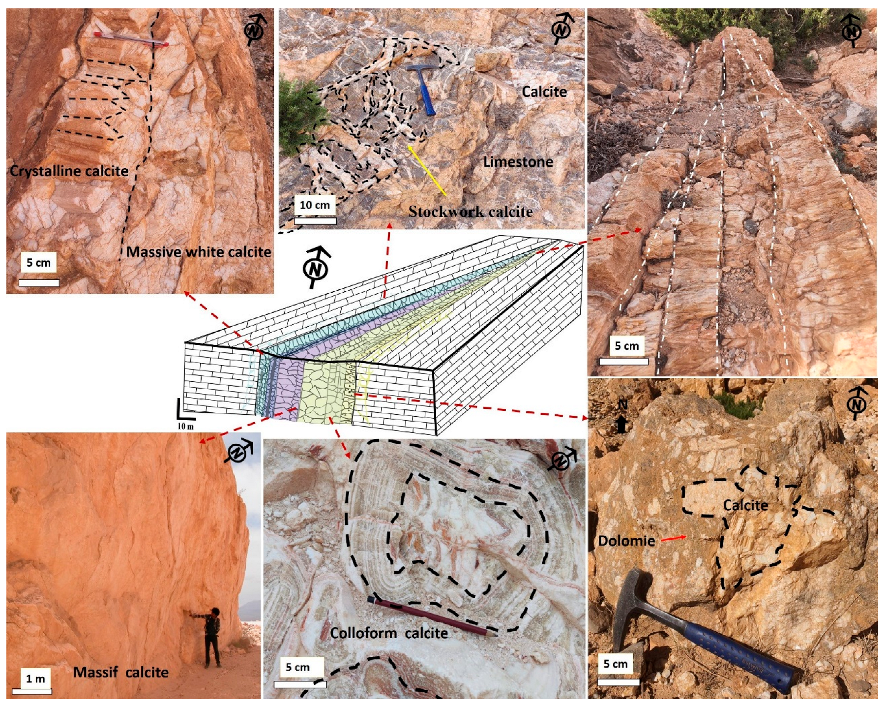
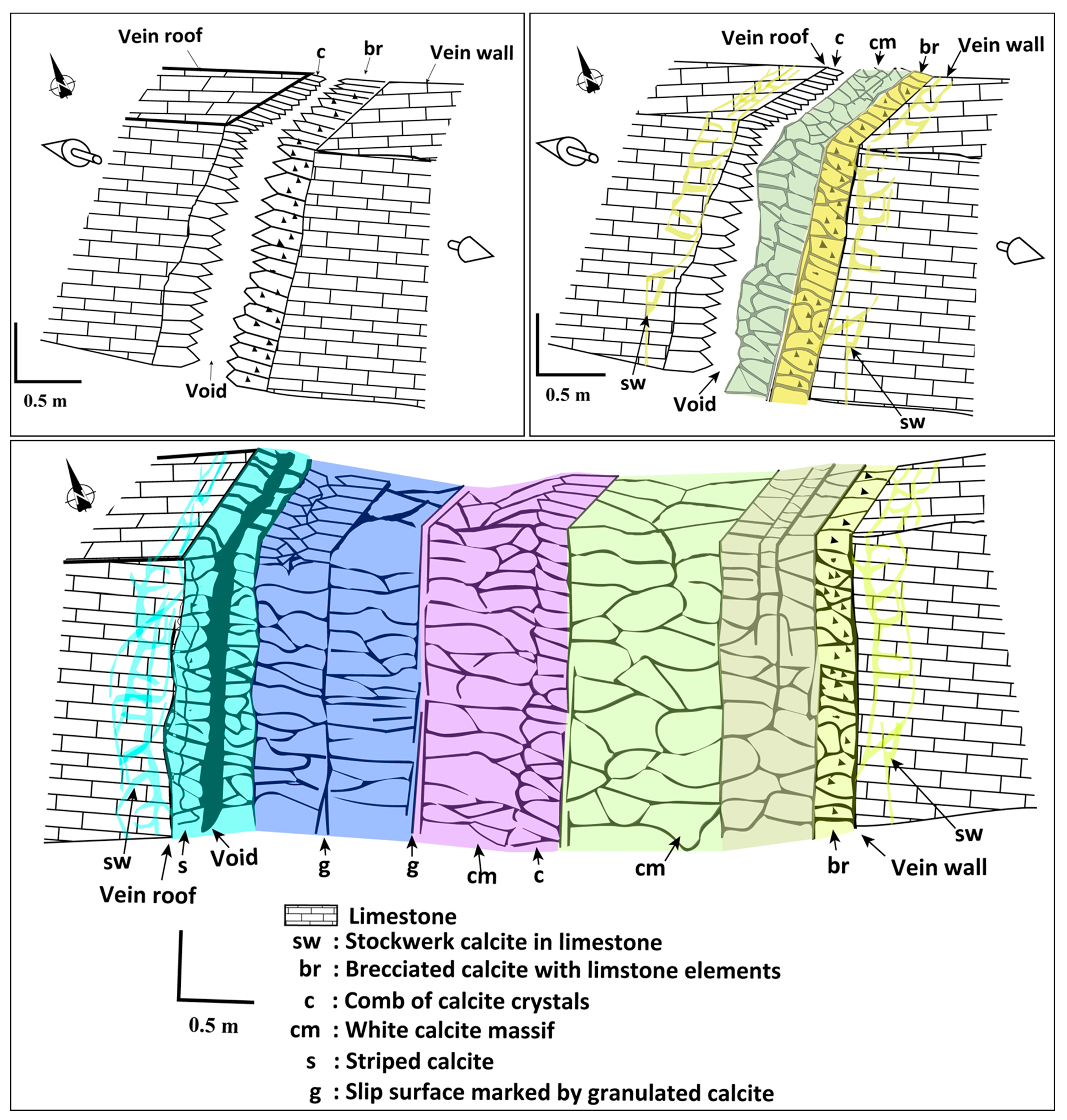
4.1.2. Ore Morphology and Calcite Textures

Calcite mineralization occurs in the carbonate rocks of the Lias, in the Tamkant formation (Figure 6 and Figure 8). Two aspects of calcite were identified at sites A and B, distinguished by their structure, morphology, size, color, and growth direction (Figure 9).
Six types of textures were identified at the two sites:
A: Stockwork calcite: This texture generally appears as centimeter veins with interconnections in the hosted dolomites and limestones (Figure 9A);
B: Honey crystalline calcite–aragonite vein: The crystals are developed in a rhombohedral form at the centimeter scale and are found in pockets inside the dolomitic host rock. They consist of an amalgam of aragonite and calcite, and their direction of growth is parallel to the extensional stress σ3 (Figure 9B);
C: Brecciated calcite in a dolomitic matrix: This texture consists of calcite remobilized in a brecciated dolomitic matrix. It often appears close to the gangue contact with the hosted rock (Figure 9C);
D: Ribbonized calcite: This texture is presented in the colloform of alternating circular bands of different colors, and it is often found close to the gangue contact (Figure 9D);
E: White calcite vein: This texture is a whitish crystalline calcite aggregate with a centimetric to decimetric scale that usually appears in the center of the vein (Figure 9E);
F: Massive calcite: This texture appears in the center of the vein at a decametric thickness scale (Figure 9F).

4.1.3. Geochemical Analysis

The analyzed samples (Figure 10) are broadly similar and representative of the calcite ore deposit at the two sites. All samples (E40, E41, and E42) showed smooth surfaces of calcite crystals surrounded by a minor flaky dolomite crystal in sample E40 (Figure 9). EDX spectral analysis of the calcite deposits revealed the presence of Ca, O, and C, and minor amounts of Mg. By conducting an EDX data analysis, we also detected the presence of Mg in the E40 sample, which may be due to the persistence of dolomite as a phase in this sample.
The E42 sample showed a higher calcium intensity than the other samples, as all of the samples possess carbon, oxygen, and calcium phase indices in the k-layer; in contrast, the E40 sample contains a trace magnesium index in the k-layer (Figure 10). The calcite crystals in these samples are rhomboid.
The elemental composition analysis of the calcite samples from the Mahdi Ridge performed by ONHYM revealed a chemical composition consisting of 99.16% CaCO3 and low (0.53%) MgO content. The loss on ignition for the sample was 43.6%, as shown in Table 2.

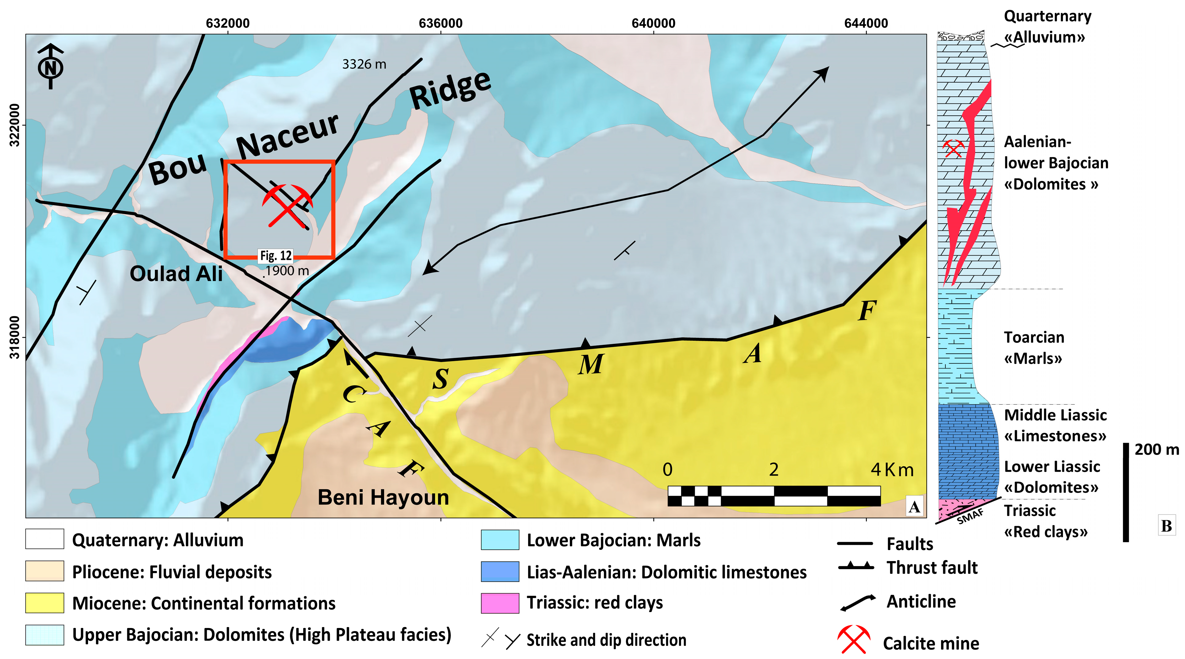
4.2. Bou Nacer Ridge: Calcite Vein System

4.2.1. Structural Study

The Bou Naceur Ridge is a faulted anticline structure controlled by the dextral Cheg El Ard Fault (CAF), considered a lateral ramp and thrust South Middle Atlas Fault type frontal ramp [29,31] (Figure 3 and Figure 11A). This ridge is an over-thrusting ramp in the Tertiary Moulouya basin. This thrusting movement began in the Miocene [27,47] and continued during the Quaternary [48,49,50]. The calcite ore deposit is located in the CAF branch and consists of vein types oriented NW-SE. High-plateau Aalenian–Lower Bajocian dolomites host calcite mineralization. Structural analysis showed dextral strike–slip movement along the NW fault system; thus, it is marked by slickenside under NNW-SSE-oriented stress (Figure 11B), and it comprises, in particular, calcite tension veins (Figure 11C).
A measurement campaign was conducted in the host of the calcite mineralization of the Bou Naceur Ridge. The results show that the maximum principal stress σ1 is horizontally oriented NNW-SSE, and the minimum principal stress σ3 is horizontally oriented ENE-WSW. The R ratio = 0.77 (Figure 12 and Figure 13 and Table 3).

4.2.2. Ore Morphology and Calcite Textures

The Bou Naceur Ridge mineralization is hosted by limestones and dolomites of the Aalenian–Lower Bajocian formation (Figure 14). The texture of calcite mineralization consists of a stockwork texture observed in the dolomitic host rock (Figure 14A) and a well-marked brecciated texture at the transition from the cover to the mineralized zone (Figure 14B). After white, milky crystalline calcite appears, the growth crystalline direction toward N75 is well marked. The calcite becomes massive and acquires a whitish appearance in the center of the vein (Figure 14C,D).
These textures are similar to the Mahdi Ridge calcite ore deposits.

4.2.3. Geochemical Analysis
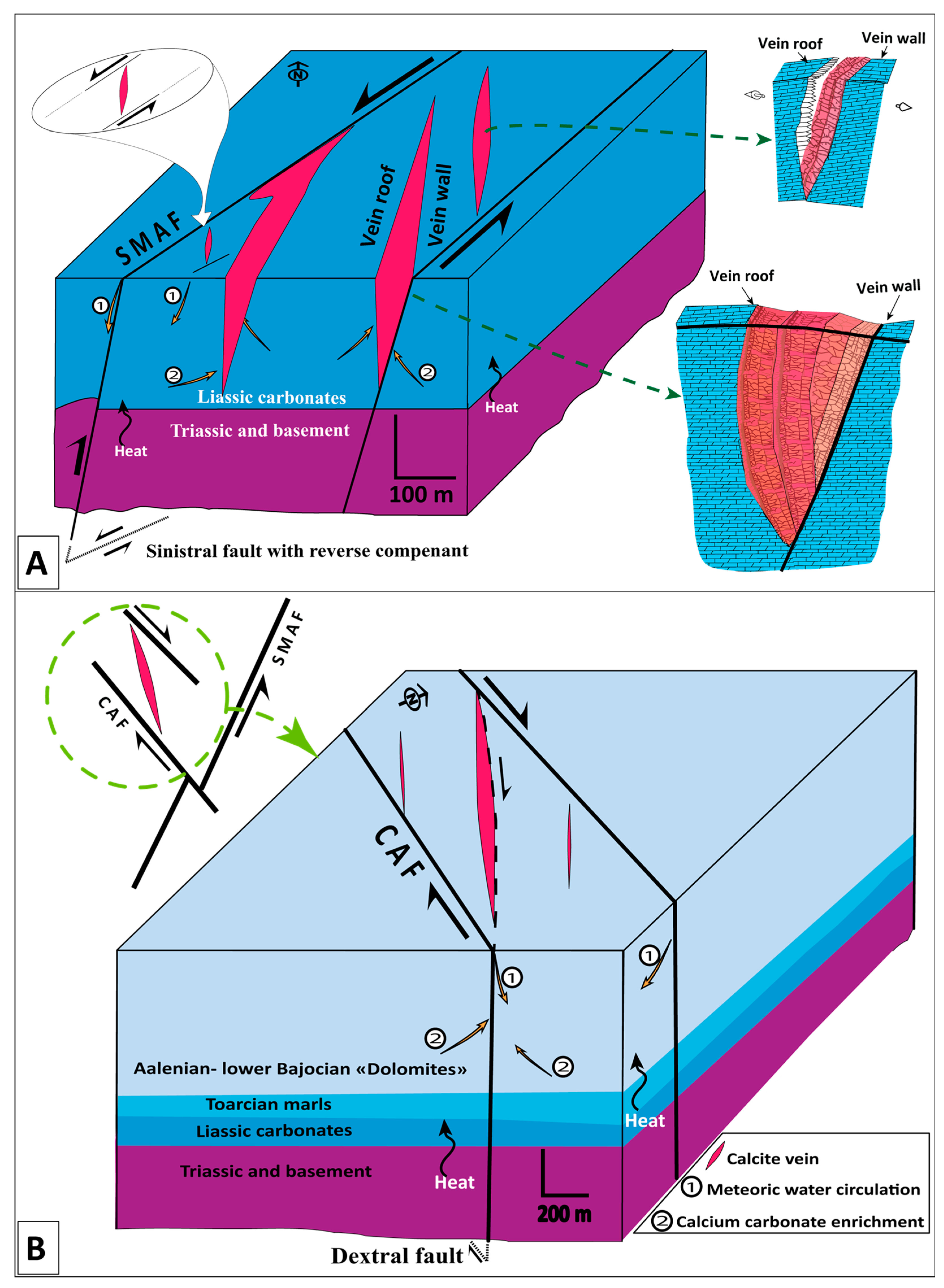
At the Bou Naceur Ridge, three representative samples of calcite in different locations were analyzed using SEM-EDX. Sample E21 represents a sample with a stockwork texture in the host dolomite rock. Sample E23 represents whitish crystalline calcite at the transition from the host rock to the center of the calcite vein. Sample E24 represents a sample of massive calcite at the center of the vein.
The results show that Sample E21 contains a fraction of Mg in the K layer, as well as Ca, C, and O. Samples E23 and E24 contain C, O, and Ca in different layers, with a higher concentration in Sample E24 than in Sample E23. Additionally, the calcite crystals in these samples are small and irregular (Figure 15).

5. Discussion

The present study was conducted on two ridges in Morocco with the potential to contain calcite: the Mahdi and Bou Naceur ridges. These ridges form NE-oriented faulted anticlines located on branches of the South Middle Atlas Fault (SMAF). Calcite mineralization is found in Lower Liassic carbonates at the Mahdi Ridge and in Aalenian–Lower Bajocian High Plateau carbonates at the Bou Naceur Ridge (Figure 16).
Calcite mineralization is mainly hosted in Jurassic carbonate formations and exhibits various textures. Stockwork is observed on the edges; brecciated textures are evident on the encasing passage leading to the mineralized zone; moreover, at the center of the vein, calcite manifests in crystalline form, gradually becoming massive and acquiring a whitish appearance. The texture order shows different stages and levels of formation and calcite development (Figure 17). At both sites, the exploitation of massive calcite and milky calcite is carried out in open pits, allowing us to establish the relationship between all textures and their representatives within the calcite vein.
The calcite has similar textures and geochemical compositions at the two sites. Geochemical and SEM-EDX analyses showed that calcium, carbon, and oxygen phases are the most dominant, while magnesium, silica, and iron are less abundant. The variety of textures, forms, and contexts of mineralization deposits on major fault zones suggests hydrothermal processes with local dissolution for hosted rocks in fault systems.
The calcite likely originates from the dissolution of carbonates in the host rock [51,52]. The development of karst cavities from enlarged fractures highlights the role of brittle tectonics in carbonate dissolution phenomena. The deposition of mineralization in the carbonate host took place at a shallow depth in relation to groundwater fluids [53,54]. Fluids are heated and circulated through the fractures and veins, enhancing their dissolution ability and enriching them with calcium carbonate. As the calcium carbonate-rich fluid approaches the surface, it cools and loses its dissolution potential, causing the CaCO3 ions to precipitate and concentrate in the fault system.
The results of previous studies show that carbonate phases often exhibit highly variable textures that identify the physical conditions associated with mineralization formation [55,56,57,58,59,60]. A variety of calcite textures have been observed at different locations in the studied calcite veins (Figure 6).
We considered different stages in the evolution of the calcite vein (Figure 18). This starts with a calcium carbonate-rich fluid that forms crystals and develops in the direction of extensional stress. When these vein structures open up again, brecciated calcite and massive white crystalline calcite form in the transtensional regime. The continuous tectonic regime creates space for the circulation of a calcium carbonate brine-rich fluid, which deposits massive crystalline calcite in the center of the vein.
The emplacement of mineralization is controlled by major adjacent faults, the most important of which is the NE South Middle Atlas Fault (SMAF) in the Mahdi Ridge and the NW Cheg El Ard Fault (CAF) in the Bou Naceur Ridge. Calcite mineralization is deposited in a mega extensional vein system in a sinistral strike–slip relay with a NE-SW stress direction in the Mahdi Ridge and dextral fault in the Bou Naceur Ridge. The South Middle Atlas Fault (SMAF) front, on which calcite mineralization is deposited, was active during the Upper Miocene–Pliocene [29,31,61]. This shows that the age of mineralization can be considered either syn or tardi movement.
Proposing a model of calcite emplacement requires a precise understanding of the nature, origin, and temperature of the fluids involved. In this case, we propose a block diagram of calcite emplacement based on the analysis of the available structural regime, form, textures, and geochemical study.
Based on the structural, textural, and geochemical characterization of this calcite ore of the Central Middle Atlas, we propose strike–slip faulting as a common mode of deformation in both areas with the following observations:
In the Sinistral Riedel fault system in the Mahdi Ridge (Figure 19A), the development of calcite ore takes place in the opening veins.
In the Dextral Riedel fault system in the Bou Naceur Ridge (Figure 19B), the development of calcite also takes place in opening veins with gradual hydrothermal dissolution and the filling of the veins.

6. Conclusions

Calcite mineralization in the Mahdi and Bou Naceur ridges occurs mainly as mega-extensional veins along the South Middle Atlas Fault (SMAF). These veins are characterized by simple paragenesis, represented by calcite hosted in Lower and Middle Jurassic carbonates. Our study of calcite mineralized structures at different scales revealed a strong connection between the control of the litho-structural and hydrothermal origins of calcite ore deposits. The carbonate nature of the host rock favors the scenario of dissolution by hot fluids resulting from a geothermal gradient under transpressive stress. This mineralization exhibits different textures, including massive, banded, crystalline, and brecciated textures. The calcite-rich brine fluid originates primarily from a hydrothermal source that results from the dissolution of the host rock. Over time, different generations of calcite are laid down in a series of continuous phases. This allows huge vein structures to form in a transpressional geodynamic setting controlled by the South Middle Atlas Fault.

Author Contributions

Conceptualization, A.A.A., Y.O. and J.C.; methodology, A.A.A. and M.C.; software, A.A.A. and H.S.M.; validation, M.C., N.E.M., H.S.M., N.S. and A.M.; formal analysis, A.A.A., M.C. and H.S.M.; investigation, M.C., A.A.A., Y.O. and J.C.; resources, A.A.A. and M.C.; data curation, A.A.A.; writing—original draft preparation, A.A.A. and M.C.; writing—review and editing, A.A.A., H.S.M., N.E.M. and M.C.; visualization, M.C., A.M., N.S. and H.S.M.; supervision, M.C. and A.M. All authors have read and agreed to the published version of the manuscript.

Funding

This research received no external funding.

Data Availability Statement

The data are available upon request.

Acknowledgments

The authors would like to express their gratitude to the Innovation City of Sidi Mohamed Ben Abdellah University for their invaluable assistance with the MEB-EDX analysis. We would also like to extend our sincere appreciation to ONHYM for their generous support with the geochemical analysis.

Conflicts of Interest

The authors declare no conflicts of interest.

References

  1. Pozo, M.; Casas, J.; Medina, J.A.; Calvo, J.P.; Silva, P.G. Caracterización de depósitos carbonáticos ligados a paleosurgencias en el sector de Batallones-Malcovadeso (Neógeno de la Cuenca de Madrid). Estud. Geológicos 2006, 62, 73–88. [Google Scholar] [CrossRef]
  2. Haldar, S.K. Minerals and rocks. In Introduction to Mineralogy and Petrology, 2nd ed.; Elsevier: Amsterdam, The Netherlands, 2020; pp. 1–51. ISBN 978-0-12-820585-3. [Google Scholar] [CrossRef]
  3. Dick, J.S.; Rader, C.P. Raw Materials Supply Chain for Rubber Products: Overview of the Global Use of Raw Materials, Polymers, Compounding Ingredients, and Chemical Intermediates; Hanser: Munich, Germany, 2014. [Google Scholar]
  4. Christian, T.; Brigitte, P.; Marie-Line, T.; Réal, D.; Bernard, L. Calcite Mineral Information Sheet. Available online: https://cerm.uqac.ca/trcm/wp-content/uploads/sites/4/2021/05/FI_07_Calcite.pdf (accessed on 12 June 2023).
  5. Ray, E. Harris Geology and Economic Potential of a High Calcium Limestone and Dolomitic Limestone Deposit Near Manville, Niobrara County, Wyoming; Geological Survey of Wyoming: Laramie, WY, USA, 1987. [Google Scholar]
  6. Aguilar, S.; Tritlla, J.; Hafid, A.; Julivert, M.; Arboleya, M.; Saidi, A. Geotectonic significance of the textural evolution of fluid inclusions in Precambrian quartz veins from the “Boutonnière de Zenaga” (Anti-Atlas, Morocco). J. Geochem. Explor. 2000, 69–70, 363–368. [Google Scholar] [CrossRef]
  7. Barker, S.L.L.; Cox, S.F.; Eggins, S.M.; Gagan, M.K. Microchemical evidence for episodic growth of antitaxial veins during fracture-controlled fluid flow. Earth Planet. Sci. Lett. 2006, 250, 331–344. [Google Scholar] [CrossRef]
  8. Faulkner, D.R.; Jackson, C.A.L.; Lunn, R.J.; Schlische, R.W.; Shipton, Z.K.; Wibberley, C.A.J.; Withjack, M.O. A review of recent developments concerning the structure, mechanics and fluid flow properties of fault zones. J. Struct. Geol. 2010, 32, 1557–1575. [Google Scholar] [CrossRef]
  9. Chauvet, A. Editorial for special issue “structural control of mineral deposits: Theory and reality. Minerals 2019, 9, 171. [Google Scholar] [CrossRef]
  10. Chauvet, A. Structural Control of Ore Deposits: The Role of Pre-Existing Structures on the Formation of Mineralised Vein Systems. Minerals 2019, 9, 56. [Google Scholar] [CrossRef]
  11. Samaoui, S.; Aabi, A.; Nguidi, M.A.; Boushaba, A.; Belkasmi, M.; Baidder, L.; Bba, A.N.; Lamrani, O.; Taadid, M.; Zehni, A. Fault-controlled barite veins of the eastern Anti-Atlas (Ougnat, Morocco), a far-field effect of the Central Atlantic opening? Structural analysis and metallogenic implications. J. Afr. Earth Sci. 2023, 204, 104970. [Google Scholar] [CrossRef]
  12. Choukrad, J.; Charroud, M.; El Moutaouakkil, N.; Saoud, N.; Ait Ali, A.; Ouahzizi, Y. Geology, Mineralogy, and Analysis of Tectonic Fracturing of Barite Mineralization’s in Bateun Jeudari Paleozoic Basement, Eastern High Atlas, Morocco. Iraqi Geol. J. 2024, 57, 46–59. [Google Scholar] [CrossRef]
  13. Morad, S.; Al-Aasm, I.S.; Sirat, M.; Sattar, M.M. Vein calcite in cretaceous carbonate reservoirs of Abu Dhabi: Record of origin of fluids and diagenetic conditions. J. Geochem. Explor. 2010, 106, 156–170. [Google Scholar] [CrossRef]
  14. Sirat, M.; Al-Aasm, I.S.; Morad, S.; Aldahan, A.; Al-Jallad, O.; Ceriani, A.; Morad, D.; Mansurbeg, H.; Al-Suwaidi, A. Saddle dolomite and calcite cements as records of fluid flow during basin evolution: Paleogene carbonates, United Arab Emirates. Mar. Pet. Geol. 2016, 74, 71–91. [Google Scholar] [CrossRef]
  15. Walter, B.F.; Burisch, M.; Fusswinkel, T.; Marks, M.A.W.; Steele-MacInnis, M.; Wälle, M.; Apukhtina, O.B.; Markl, G. Multi-reservoir fluid mixing processes in rift-related hydrothermal veins, Schwarzwald, SW-Germany. J. Geochem. Explor. 2018, 186, 158–186. [Google Scholar] [CrossRef]
  16. Todaro, S.; Manniello, C.; Pietragalla, A.; Preto, N.; Agosta, F. Depositional Setting, Diagenetic Processes, and Pressure Solution-Assisted Compaction of Mesozoic Platform Carbonates, Southern Apennines, Italy. Geosciences 2024, 14, 89. [Google Scholar] [CrossRef]
  17. Termier, H. Etudes Géologiques Sur Le Maroc Central et Le Moyen-Atlas Septentrional. 1936. Available online: https://www.persee.fr/doc/rga_0035-1121_1937_num_25_3_3982_t1_0525_0000_1 (accessed on 14 August 2023).
  18. Colo, G. Contribution a L’étude Du Jurassique Du Moyen Atlas Septentrional: Atlas de Planches Hors Texte; Éd. de la Division de la Géologie, Direction, Ministère, Royaume du Maroc. 1961. Available online: https://bibliotheques.mnhn.fr/medias/detailstatic.aspx?INSTANCE=exploitation&RSC_BASE=HORIZON&RSC_DOCID=379840 (accessed on 14 August 2023).
  19. Choubert, G.; Faure-Muret, A. Etudes sur le le Jurassique du Moyen-Atlas (Maroc): Le Jurassique de la région d’El Mers-Skoura (Moyen-Atlas). Notes et Mémoires du Service Géologique Du Maroc 1967, 200, 1–32. [Google Scholar]
  20. Mattauer, M.; Tapponnier, P.; Proust, F. Sur les mécanismes de formation des chaînes intracontinentales. L’exemple des chaînes atlasiques du Maroc. Bull. Société Géologique Fr. 1977, 7, 521–526. [Google Scholar] [CrossRef]
  21. Laville, E.; Charroud, A.; Fedan, B.; Charroud, M.; Pique, A. Inversion negative et rifting atlasique: L’exemple du bassin triasique de Kerrouchene (Maroc). Bull.-Soc. Geol. Fr. 1995, 166, 365–374. [Google Scholar] [CrossRef]
  22. Beauchamp, W.; Barazangi, M.; Demnati, A.; El Alji, M. Intracontinental rifting and inversion: Missour basin and Atlas mountains, Morocco. AAPG Bull. 1996, 80, 1459–1482. [Google Scholar]
  23. Beauchamp, W.H. Tectonic Evolution of the Atlas Mountains, North Africa. Ph.D. Thesis, Cornell University, Ithaca, NY, USA, 1998. [Google Scholar]
  24. Choukrad, J.; Ouahzizi, Y.; Ait Ali, A.; Charroud, M. Geology, mineralogy, geochemistry and deposit model of iron and manganese in Bouarfa mine, Eastern High Atlas, Morocco. Sci. Afr. 2022, 18, e01401. [Google Scholar] [CrossRef]
  25. Ouahzizi, Y.; Azzab, D.E.; Charroud, M.; Tazi, M.J.; Ali, A.A. Gravity Interpretations to Investigate the Deep Geological and Structural Status of Middle Atlas Chain Region, Morocco. Iraqi Geol. J. 2023, 56, 1–18. [Google Scholar] [CrossRef]
  26. Laville, E. L’évolution sédimentaire et tectonique de la couverture jurassique de la région d’Immouzzer de Marmoucha (Moyen Atlas-Maroc). Bull. Soc. Géol. Fr. 1977, 19, 1151–1158. [Google Scholar] [CrossRef]
  27. Martin, J. Le Moyen Atlas Central, Étude Géomorphologique. 1981. [En ligne]. Available online: https://pascal-francis.inist.fr/vibad/index.php?action=getRecordDetail&idt=PASCALGEODEBRGM8220223851 (accessed on 19 November 2022).
  28. Dresnay, R.D. Recent data on the geology of the Middle Atlas (Morocco). Atlas Syst. Moroc. 1988, 15, 293–320. [Google Scholar]
  29. Charroud, M. Evolution Géodynamique des Hauts Plateaux (Maroc) et de Leurs Bordures du Mesozoique au Cénozoique. Ph.D. Thesis, Université de Fès, Fès, Morocco, 2002; 315p. [Google Scholar]
  30. Charroud, M.; Cherai, B.; Benabdelhadi, M.; Falguères, C. Impact de la néotectonique quaternaire sur la dynamique sédimentaire du Saïs (Maroc): Du bassin d’avant fosse pliocène au plateau continental quaternaire. Int. J. Fr. Quat. Assoc. 2007, 18, 327–334. [Google Scholar] [CrossRef]
  31. Delcaillau, B.; Laville, E.; Carozza, J.M.; Dugué, O.; Charroud, M.; Amrhar, M. Morphotectonic evolution of the Jebel Bou Naceur in the South Middle Atlas Fault Zone (Morocco). C. R.-Geosci. 2007, 339, 553–561. [Google Scholar] [CrossRef]
  32. Laville, E.; Pique, A.; Amrhar, M.; Charroud, M. A restatement of the Mesozoic Atlasic Rifting (Morocco). J. Afr. Earth Sci. 2004, 38, 145–153. [Google Scholar] [CrossRef]
  33. Hollard, H.; Choubert, G.; Bronner, G.; Marchand, J.; Sougy, J. Carte Géologique du Maroc, scale 1/1,000,000. In Notes et Mémoires du Service Géologique du Maroc; Service Géologique du Maroc: Rabat, Morocco, 1985; 260p. [Google Scholar]
  34. Dresnay, R. du Donnees stratigraphiques complementaires sur le Jurassique moyen des synclinaux d’El Mers et de Skoura (Moyen-Atlas, Maroc). Bull. Société Géologique Fr. 1963, S7-V, 883–900. [Google Scholar] [CrossRef]
  35. Elmi, S.; Almeras, Y.; Benshili, K. Influence of palaeogeography on Liassic populations of the Moroccan Middle Atlas. Sci. Geol.-Mem. 1989, 83, 115–131. [Google Scholar]
  36. Benshili, K. Lias-Dogger du Moyen-Atlas plissé (Maroc). Sédimentologie, biostratigraphie et évolution paléogéographique. Trav. Doc. Lab. Géologie Lyon 1989, 106, 3–285. [Google Scholar]
  37. Fedan, B. Evolution Géodynamique d’un Bassin Intraplaque sur Décrochements: Le Moyen Atlas (Maroc) Durant le Méso-Cénozoïque; Série Géologie et Géographie Physique; Institut Scientifique: Rabat, Morocco, 1989; Volume 18. [Google Scholar]
  38. Dubar, G.; Despujols, M.P. Carte Géologique Provisoire du Haut-Atlas de Midelt au 1/200,000 e; Service de la Carte Géologique du Maroc: Rabat, Morocco, 1948. [Google Scholar]
  39. Arabi, H.E.; Charrière, A.; Sabaoui, A.; Ouahhabi, B.; Kerchaoui, S.; Boutakiout, M.; Laadila, M. Toarcian and Aalenian series from the folded northern part of Middle Atlas (Morocco): Diversity of the depositional processes and reconstruction of the palaeogeographic setting [Le Toarcien et l’Aalenien dans le nord du Moyen-Atlas plisse (Maroc): Diversite de l’enregistrement sedimentaire et reconstitution du contexte paleogeographique]. Bull. Soc. Geol. Fr. 1999, 170, 629–641. [Google Scholar]
  40. Arabi, H.E.; Ouahhabi, B.; Charriere, A. New stratigraphical data and paleogeographical significance of the Toarcian-Aalenian series from the Southwestern part of the Middle Atlas (Morocco). Bull. Soc. Geol. Fr. 2001, 172, 723–736. [Google Scholar] [CrossRef]
  41. Delvaux, D.; Moeys, R.; Stapel, G.; Petit, C.; Levi, K.; Miroshnichenko, A.; Ruzhich, V.; San’kov, V. Paleostress reconstructions and geodynamics of the Baikal region, Central Asia, Part 2. Cenozoic rifting. Tectonophysics 1997, 282, 1–38. [Google Scholar] [CrossRef]
  42. Delvaux, D.; Sperner, B. New aspects of tectonic stress inversion with reference to the TENSOR program. Geol. Soc. Lond. Spec. Publ. 2003, 212, 75–100. [Google Scholar] [CrossRef]
  43. Delvaux, D.; Barth, A. African stress pattern from formal inversion of focal mechanism data. Tectonophysics 2010, 482, 105–128. [Google Scholar] [CrossRef]
  44. Delvaux, D. Release of program Win-Tensor 4.0 for tectonic stress inversion: Statistical expression of stress parameters. In Geophysical Research Abstracts, Proceedings of the EGU General Assembly Vienna, Vienna, Austria, 22–27 April 2012; Africa Tervuren: Tervuren, Belgium, 2012. [Google Scholar]
  45. Angelier, J. Determination of the mean principal directions of stresses for a given fault population. Tectonophysics 1979, 56, T17–T26. [Google Scholar] [CrossRef]
  46. ONHYM. Calcite de Jbel Mahdi; Bilan des travaux de recherches; ONHYM: Rabat, Morocco, 1996. [Google Scholar]
  47. Colletta, B. Evolution Néotectonique de la Partie Méridionale du Bassin de Guercif (Maroc Oriental). 1977. Available online: https://theses.hal.science/tel-00759882/ (accessed on 27 January 2023).
  48. Gomez, F.; Beauchamp, W.; Barazangi, M. Role of the Atlas Mountains (northwest Africa) within the African-Eurasian plate-boundary zone. Geology 2000, 28, 775–778. [Google Scholar] [CrossRef]
  49. Frizon de Lamotte, D.; Michard, A.; Saddiqi, O. Some recent developments on the Maghreb geodynamics|Quelques développements récents sur la géodynamique du Maghreb. C. R.-Geosci. 2006, 338, 1–10. [Google Scholar] [CrossRef]
  50. Sébrier, M.; Siame, L.; Zouine, E.M.; Winter, T.; Missenard, Y.; Leturmy, P. Active tectonics in the Moroccan High Atlas. C. R.-Geosci. 2006, 338, 65–79. [Google Scholar] [CrossRef]
  51. Halavínová, M.; Melichar, R.; Quarterly, M.S.-G. Hydrothermal Veins Linked with the Variscan Structure of the Prague Synform (Barrandien, Czech Republic): Resolving Fluid-Wall Rock Interaction. yadda.icm.edu.pl 2008. Available online: https://yadda.icm.edu.pl/baztech/element/bwmeta1.element.baztech-article-BUS6-0018-0035 (accessed on 10 August 2023).
  52. Simpson, A.; Glorie, S.; Morley, C.K.; Roberts, N.M.W.; Gillespie, J.; Lee, J.K. In-situ calcite U-Pb geochronology of hydrothermal veins in Thailand: New constraints on Indosinian and Cenozoic deformation. J. Asian Earth Sci. 2021, 206. [Google Scholar] [CrossRef]
  53. Bottrell, S.H.; Crowley, S.; Self, C. Invasion of a karst aquifer by hydrothermal fluids: Evidence from stable isotopic compositions of cave mineralization. Geofluids 2001, 1, 103–121. [Google Scholar] [CrossRef]
  54. Perry, E.; Gysi, A.P. Hydrothermal calcite-fluid REE partitioning experiments at 200 °C and saturated water vapor pressure. Geochim. Cosmochim. Acta 2020, 286, 177–197. [Google Scholar] [CrossRef]
  55. Barber, D.J.; Wenk, H.-R. Deformation twinning in calcite, dolomite, and other rhombohedral carbonates. Phys. Chem. Miner. 1979, 5, 141–165. [Google Scholar] [CrossRef]
  56. Wenk, H.-R.; Takeshita, T.; Bechler, E.; Erskine, B.G.; Matthies, S. Pure shear and simple shear calcite textures. Comparison of experimental, theoretical and natural data. J. Struct. Geol. 1987, 9, 731–745. [Google Scholar] [CrossRef]
  57. Simmons, S.F.; Christenson, B.W. Origins of calcite in a boiling geothermal system. Am. J. Sci. 1994, 294, 361–400. [Google Scholar] [CrossRef]
  58. Dong, G.; Morrison, G.; Jaireth, S. Quartz textures in epithermal veins, Queensland—Classification, origin, and implication. Econ. Geol. 1995, 90, 1841–1856. [Google Scholar] [CrossRef]
  59. Moncada, D.; Mutchler, S.; Nieto, A.; Reynolds, T.J.; Rimstidt, J.D.; Bodnar, R.J. Mineral textures and fluid inclusion petrography of the epithermal Ag–Au deposits at Guanajuato, Mexico: Application to exploration. J. Geochem. Explor. 2012, 114, 20–35. [Google Scholar] [CrossRef]
  60. Hashim, M.S.; Kaczmarek, S.E. Experimental stabilization of carbonate sediments to calcite: Insights into the depositional and diagenetic controls on calcite microcrystal texture. Earth Planet. Sci. Lett. 2020, 538, 116235. [Google Scholar] [CrossRef]
  61. Medina, F.; Cherkaoui, T.-E. The Midelt earthquake of November 17th 2019, and its implications on the present-day tectonics of the junction of the High and Middle Atlas (Morocco). Arab. J. Geosci. 2021, 14, 1717. [Google Scholar] [CrossRef]
Figure 2. (A) Mahdi Ridge geological map (see Figure 1 for location); (B) the synthetic lithostratigraphic column (SMAF: South Middle Atlas Fault).
Geosciences 14 00154 g002
Figure 3. (A) Geological map (see Figure 1 for location); (B) synthetic lithostratigraphic column of the Bou Naceur Ridge (SMAF: South Middle Atlas Fault; CAF, Cheg El Ard Fault).
Geosciences 14 00154 g003
Figure 4. The NE operating mine in the Mahdi ridge (see Figure 2 for location); site A: Mahdi calcite mine “South site”, north view; site B: Mahdi calcite mine “North site”, eastern view. (A to D represent measurement site locations).
Geosciences 14 00154 g004
Figure 5. The slickensides indicate the type and direction of movement (see Figure 4 for location): Site A: slickensides on limestone indicating a sinistral strike–slip fault (A,B); site B: slickensides on Triassic deposits indicating a reverse fault (C) and a sinistral strike–slip fault (D) in limestone (arrow = movement of missing bloc).
Geosciences 14 00154 g005
Figure 6. A detailed geological map of the Mahdi Ridge (see Figure 2 for location).
Geosciences 14 00154 g006
Figure 7. Paleostress configuration of calcite veins in sites (A,B) of the Mahdi Ridge (the blue arrow indicates stress, the red arrow indicates extension, and the black arrow indicates the direction of movement).
Geosciences 14 00154 g007
Figure 8. Location of calcite texture found in the Mahdi ridge (see Figure 6 for location); site (A): Mahdi calcite mine, “South site”, north view of the site with the sample location; site (B): Mahdi calcite mine, “North site”, eastern view of the site with the sample location (A to F represent calcite texture locations).
Geosciences 14 00154 g008
Figure 9. Calcite textures in the Mahdi Ridge mine (see Figure 8 for location): stockwork texture (A); honey crystalline calcite–aragonite vein (B); brecciated calcite in the dolomitic matrix (C); ribbonized calcite (D); white calcite vein (E); massive calcite (F).
Geosciences 14 00154 g009
Figure 10. SEM images and EDX spectra results for the Mahdi Ridge calcite samples (E40, E41, and E42; see Figure 9 for location).
Geosciences 14 00154 g010
Figure 11. (A) A wide-angle view of the Bou Naceur Ridge; (B) the location of the calcite mine and measurement sites for the structure; (C) calcite tension vein; (D) slickenside, which shows a dextral fault (arrow = movement of fault; red stars C and D are indicators of tectonic movements).
Geosciences 14 00154 g011
Figure 12. Detailed geological map of the calcite ore on the Bou Naceur Ridge (see Figure 3 for location).
Geosciences 14 00154 g012
Figure 13. Paleostress configuration of calcite veins in the Bou Naceur Ridge (the blue arrow indicates stress, the red arrow indicates extension, and the black arrow indicates the direction of movement).
Geosciences 14 00154 g013
Figure 14. Field photos at the Bou Naceur Ridge showing the morphology of the calcite texture in red star. (A) Stockwork texture, (B) breccia texture, and (C,D) crystalline and massive textures.
Geosciences 14 00154 g014
Figure 15. SEM images and EDX spectra results of the Bou Naceur Ridge calcite samples (E21, E23, and E24; see Figure 14 for location).
Geosciences 14 00154 g015
Figure 16. Correlation between synthetic lithostratigraphic columns and the actual situation of the calcite mineralization period in Jbel Mahdi (A) and Jbel Bou Naceur (B).
Geosciences 14 00154 g016
Figure 17. Summary of the textures and morphology of the calcite structures, along with their respective positions within the veins found in the two sectors.
Geosciences 14 00154 g017
Figure 18. Evolution phases of calcite textures and their relationship with the host rock in a small-scale transtensive system.
Geosciences 14 00154 g018
Figure 19. Hypothetical block diagrams of calcite deposits in the Middle Atlas: (A) sinistral Riedel fault system with calcite veins in the Mahdi Ridge and (B) dextral Riedel fault system with calcite veins in the Bou Naceur Ridge.
Geosciences 14 00154 g019
Table 1. Stress parameters calculated from fault striations in the Mahdi Ridge.
SectorRosas NameLatitudeLongitudenσ1σ2σ3RαTectonic Regime
Mahdi RidgeMahdi Ridge (site A)33°18′58.13″ N4°23′34.19″ W715/03875/22903/1290.552Sinistral strike–slip fault
Mahdi Ridge (site B)33°19′19.01″ N4°22′40.00″ W627/03750/26927/1420.070.9Sinistral strike–slip fault
Table 2. Mahdi Ridge calcite geochemical analysis results [46].
Element Grade (%)
CaCO399.16
Mgo0.53
SiO20.11
Fe (total)0.02
Fire loss43.6
Insoluble acid0.10
Table 3. Stress parameters calculated from fault striations.
SectorVein NameLatitudeLongitudeNσ1σ2σ3RαTectonic Regime
Bou NaceurOulad Ali33°28′15.82″ N3°57′47.69″ W711/16367/27920/0690.773.5Dextral strike–slip fault
Disclaimer/Publisher’s Note: The statements, opinions and data contained in all publications are solely those of the individual author(s) and contributor(s) and not of MDPI and/or the editor(s). MDPI and/or the editor(s) disclaim responsibility for any injury to people or property resulting from any ideas, methods, instructions or products referred to in the content.

