Article

Effect of Depositional Environment and Climate on Organic Matter Enrichment in Sediments of the Upper Miocene—Pliocene Kampungbaru Formation, Lower Kutai Basin, Indonesia

1
Department of Geology, Faculty of Earth Sciences, Geography and Astronomy, University of Vienna, 1090 Vienna, Austria
2
Geological Study Program, Sekolah Tinggi Teknologi Migas Balikpapan, Balikpapan 76127, Indonesia
3
Geophysics Department, Science and Mathematics Faculty, Hasanuddin University, Makassar 90245, Indonesia
4
Geology Department, Faculty of Science, Minia University, Minia 61519, Egypt
*
Author to whom correspondence should be addressed.
Geosciences 2024, 14(6), 164; https://doi.org/10.3390/geosciences14060164
Submission received: 23 April 2024 / Revised: 3 June 2024 / Accepted: 7 June 2024 / Published: 12 June 2024

Abstract

:
The Upper Miocene–Pliocene Kampungbaru Formation crops out in the easternmost part of the Lower Kutai Basin, Indonesia. The sedimentological analysis of seven outcrops was carried out, and a total of twenty-five samples from these outcrops was analyzed for bulk geochemistry, organic petrography, and bulk and clay mineralogy to assess the effect of the climate and depositional environment on organic matter enrichment. The Kampungbaru Formation consists of interbedded sandstone, siltstone, claystone, and thick coal beds, which were classified into eleven lithofacies. Subsequently, seven facies associations were identified, namely the fluvial-dominated distributary channel, sheet-like sandstone, tide-influenced distributary channel, mouth bar, crevasse splay, delta plain, and delta front. The coal facies generally have a high amount of total organic carbon (TOC, 5.1–16.9; avg. 10.11 wt.%), and non-coal layers range from 0.03 to 4.22 wt.% (avg. 1.54 wt.%). The dominant maceral is vitrinite, while liptinite occurs only rarely in the samples. Organic matter is inferred to have originated from terrestrial plants growing in mangrove swamps. Identified clay minerals include varying proportions of kaolinite, illite, chlorite, and mixed layer illite/smectite (I/S). Kaolinite, which commonly constitutes up to 30% of the clay volume, indicates intensive chemical weathering during a warm and humid climate. In accordance with the Köppen climate classification, the paleoclimate during the deposition of the Kampungbaru Formation is classified as type Af, which is a tropical rainforest. Tropical climate was favorable for the growth of higher plants and deposition of organic matter under anoxic conditions and led to higher amounts of TOC in the Kampungbaru Formation.

1. Introduction

Mudstones, shale, and coal are sedimentary rocks that have unique physical and chemical properties associated with their organic and inorganic components [1,2]. The organic matter enrichment of fine-grained sedimentary rocks is significantly influenced by climatic conditions and the sedimentary environment, as well as the changes within these settings [3]. Climate change directly affects sediment supply and water stratification, as well as the enrichment and preservation of organic matter. Worldwide, large amounts of terrestrial organic matter are transported by fluvial systems into oceans. The quantity and distribution of organic matter in sediments are strongly controlled by environmental processes, and therefore, the analysis of the depositional paleoenvironment can lead to a better understanding of organic matter enrichment. Ultimately, different depositional environments influence the type and quality of organic matter, which, in turn, affects the formation of oil and gas.
Delta sediments, such as the Mahakam Delta of Indonesia, provide insights into organic matter accumulation and their (paleo)climatic controls. The persistent wet climate is highlighted as a crucial factor contributing to the formation of organic-rich source rocks in the circum-Borneo region during the Middle Miocene [4,5]. Based on the biomarker analyses and the examination of pollen records, Widodo [6] proposed a climatic shift towards cooler and drier conditions at the end of the Late Miocene in the Mahakam Delta region along the eastern Kalimantan. This climatic change is linked to a transition from rainforest vegetation to more open savanna vegetation and an increase in Gramineae pollen. These findings contribute to our understanding of past climate dynamics and ecosystem responses in the region during the Miocene epoch [4,5,6].
Fine-grained lithologies are known to contain significant amounts of organic material, which transforms into hydrocarbons under specific geological conditions. Several mega sequences with a shallowing upward trend from bathyal mudstones to delta plain/fluvial channel sandstone were deposited during the eastward progradation of the deltaic system in the eastern part of the Kutai Basin [7,8,9]. The basin with thick Miocene and Pliocene sediments that have been proven to contain large hydrocarbon reserves has been intensively studied for more than a century, indicating its ongoing importance in the global energy landscape [10].
Existing studies that included the Lower Kutai Basin have mainly focused on paleoclimate reconstructions on general sedimentary characteristics of deltaic successions within the Mahakam Delta or have dealt with the hydrocarbon potential of the Miocene Balikpapan Formation [7,9], which represents the most important source rock in the basin. The focus of this study is the overlying, relatively poorly known Kampungbaru Formation, which consists of alternating sandstone, siltstone, claystone, and coal. Sediments of the formation were deposited in the southeastern part of the Lower Kutai Basin during the Upper Miocene to Pliocene period [7]. Detailed knowledge of the depositional environment and climatic conditions is a key factor that enables the better assessment of organic matter enrichment and of the potential for hydrocarbon generation and accumulation within the Kampungbaru Formation. However, research on the reconstruction of the depositional environment and source rock potential of the formation has never been conducted.
This study benefited from the integrated multidisciplinary approach of sedimentology, bulk geochemistry, organic petrography, and clay mineralogy. The objectives include lithofacies definition, the interpretation of depositional environments, clay mineralogy, and maceral analysis. The integration of all aspects has improved our understanding of the depositional and climatic history of the Kampungbaru Formation, with a focus on organic matter enrichment, distribution, and preservation in sediments of the Kampungbaru Formation.

2. Geological Setting

The Kutai Basin is the largest and deepest Cenozoic basin in Indonesia. The majority of hydrocarbons in the basin is found in deltaic-to-shallow marine sandstone reservoirs of Middle-to-Late Miocene age [10,11,12] (Figure 1A).
The study area is located in the southeastern part of the Lower Kutai Basin (Balikpapan region) and is delimited by the recent Mahakam Delta to the north and the Adang Fault (Adang Flexure) to the south. The area further comprises the Samarinda Anticlinorium and the Paternoster Platform. These structural elements, and especially the Adang Fault, played a key role in the structural evolution of the Balikpapan region [13,14]. The Kampungbaru and Balikpapan formations (Figure 1B) provide insights into the sedimentary history of the Balikpapan region, including varying depositional environments and processes [14]. The Upper Miocene to Pliocene Kampungbaru Formation is typically 100 to 800 m thick and consists of sandstone, siltstone, and claystone intercalated with coal. Commonly occurring coal seams and lignite beds are typically less than 3 m thick. The Kampungbaru Formation was deposited in a deltaic and shallow marine environment (Figure 1C) [15].
Figure 1. (A) Geological map of Borneo (modified after [16]); (B) The study area is located in the Balikpapan area in the southern part of the Lower Kutai Basin. The sampling locations are shown by numbers. (C) Stratigraphy and lithology of the Kutai Basin modified after [7,15]. This study focused on the Kampungbaru Formation, as indicated by the orange box.
Geosciences 14 00164 g001

3. Materials and Methods
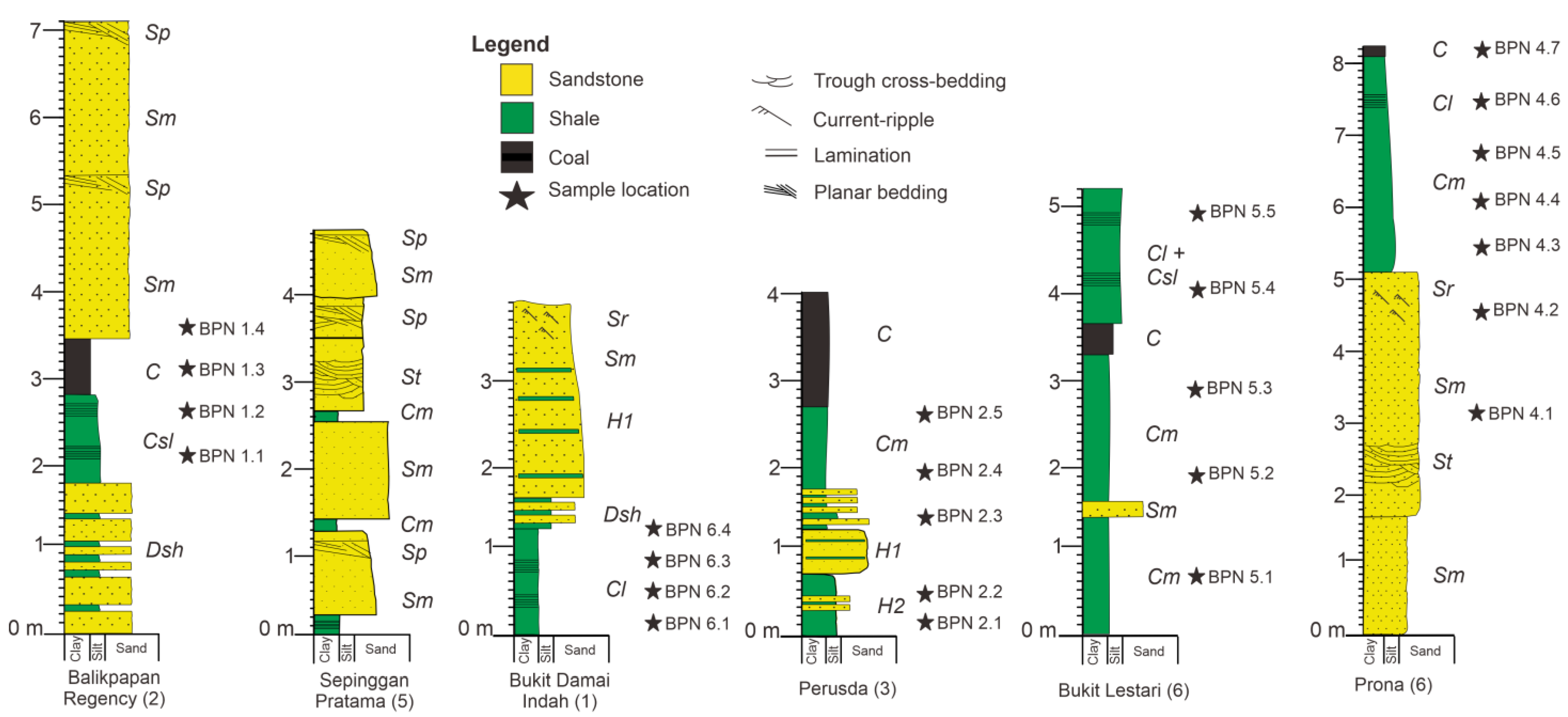
3.1. Field Data

A total of twenty-five samples were collected from six outcrop sections belonging to the Kampungbaru Formation in the Balikpapan region in order to study sedimentology, clay mineralogy, organic content, and organic matter distribution and preservation. The total thickness of the measured sections is 35 m.

3.2. Leco Elemental Analysis

The total organic carbon (TOC) content was determined on about 100 mg of the powdered samples with a LECO RC-612 Carbon Analyzer manufactured by LECO Corporation, an American company with analytical errors less than ±1%. The TOC analyses were conducted at the Department of Geology, University of Vienna, Austria. Total inorganic carbon (TIC = TC − TOC) was used to calculate calcite equivalent percentages (CEq = TIC × 8.34 [%]).

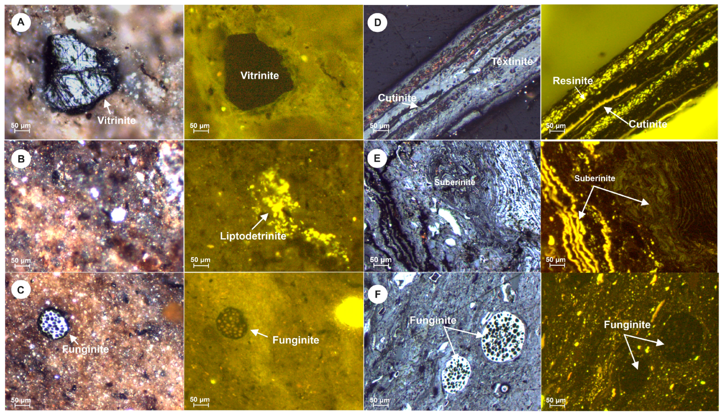
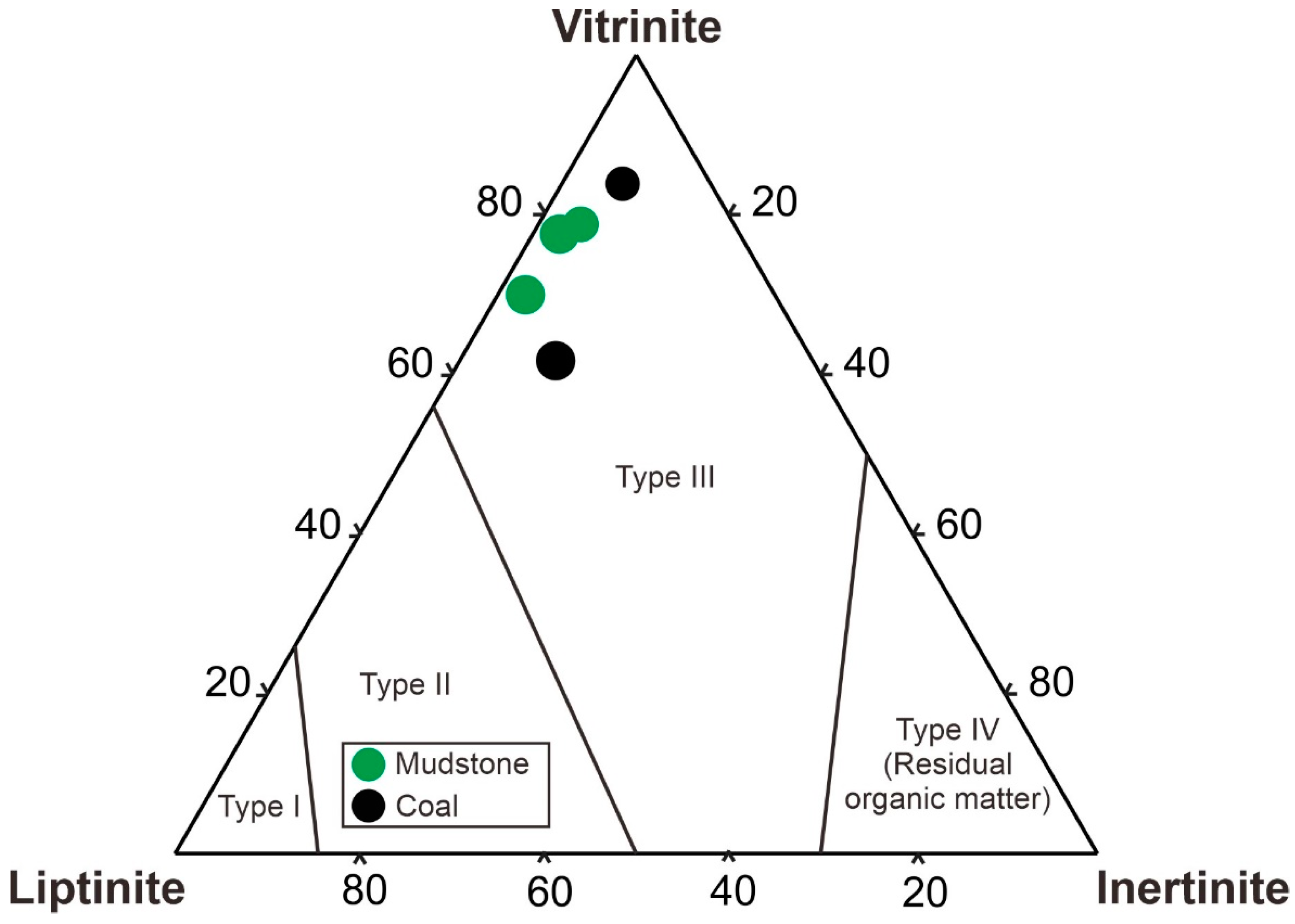
3.3. Organic Petrography

A total of five samples were chosen for organic petrography analysis. The selection criteria were based on the stratigraphic distribution of the samples and the availability of geochemical data. The organic petrography analysis involved the examination of polished blocks of rock samples under both white and fluorescent light using a Leica DM 4P microscope fitted with a 50× oil immersion objective (Department of Applied Geosciences and Geophysics, Montanuniversitaet Leoben, Austria) with specific emphasis on maceral analysis and point counting. The use of standardized procedures and terminology enhances the reliability and comparability of the results. Approximately 1500 points for mudstone samples and 500 points for coal samples were counted during the analysis. Point counting is a method to quantitatively assess the distribution of different components in a rock sample. The results obtained from the point counting were normalized to represent 100 percent organic matter. Normalization allows for a standardized comparison of different samples. The terminology used in the analysis aligns with the International Committee for Coal and Organic Petrology (ICCP) classification system [17,18,19].

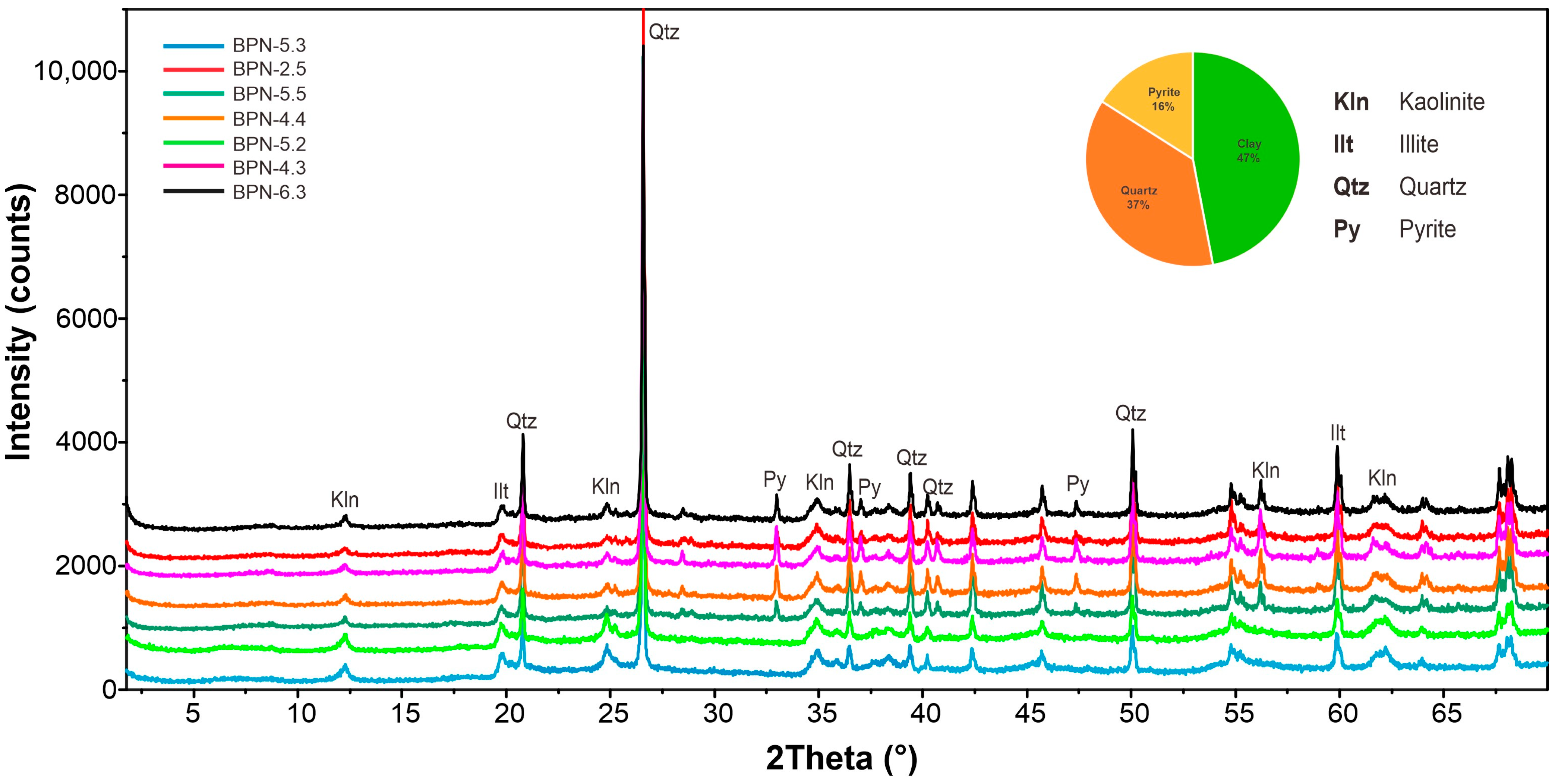
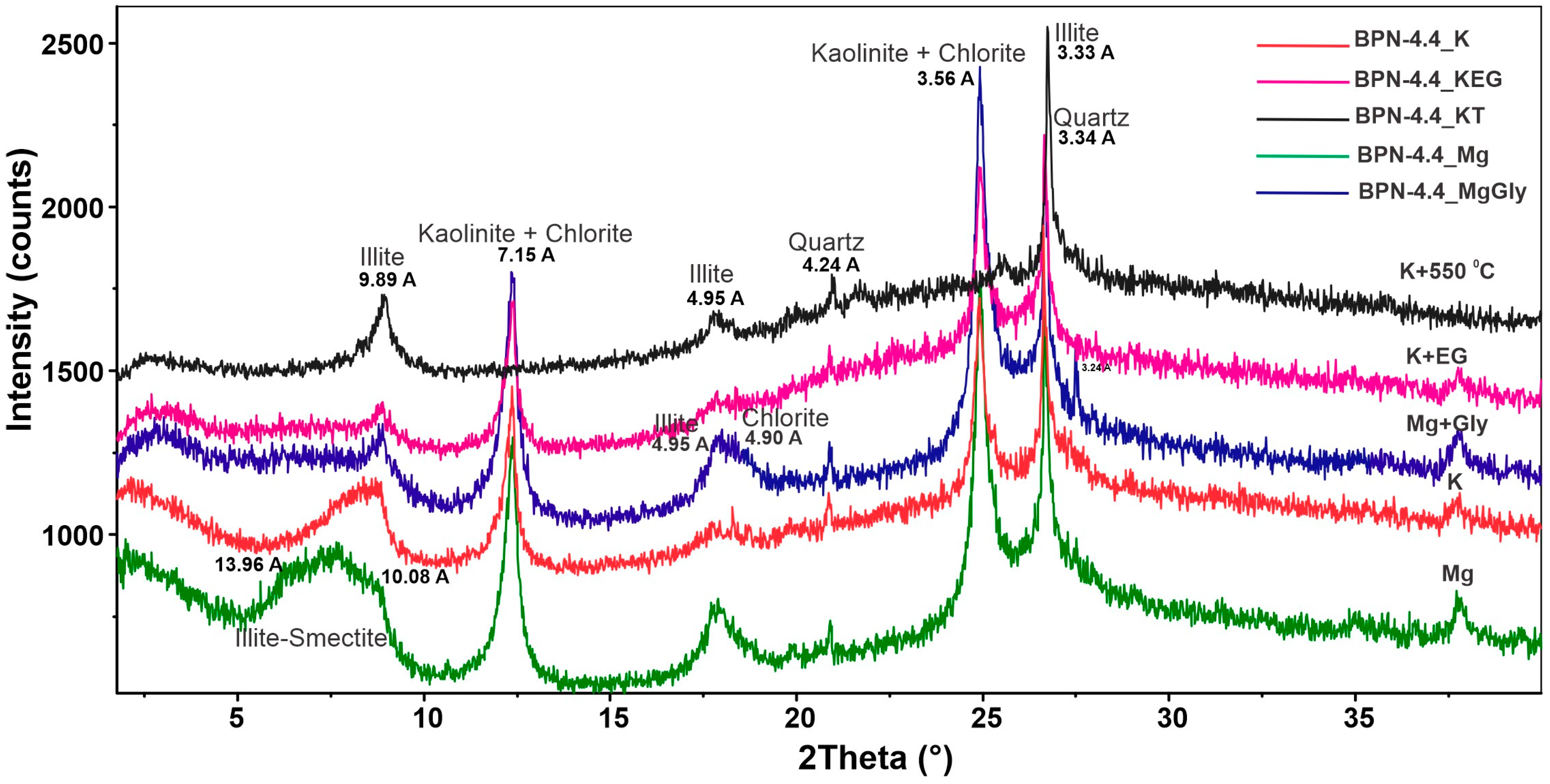
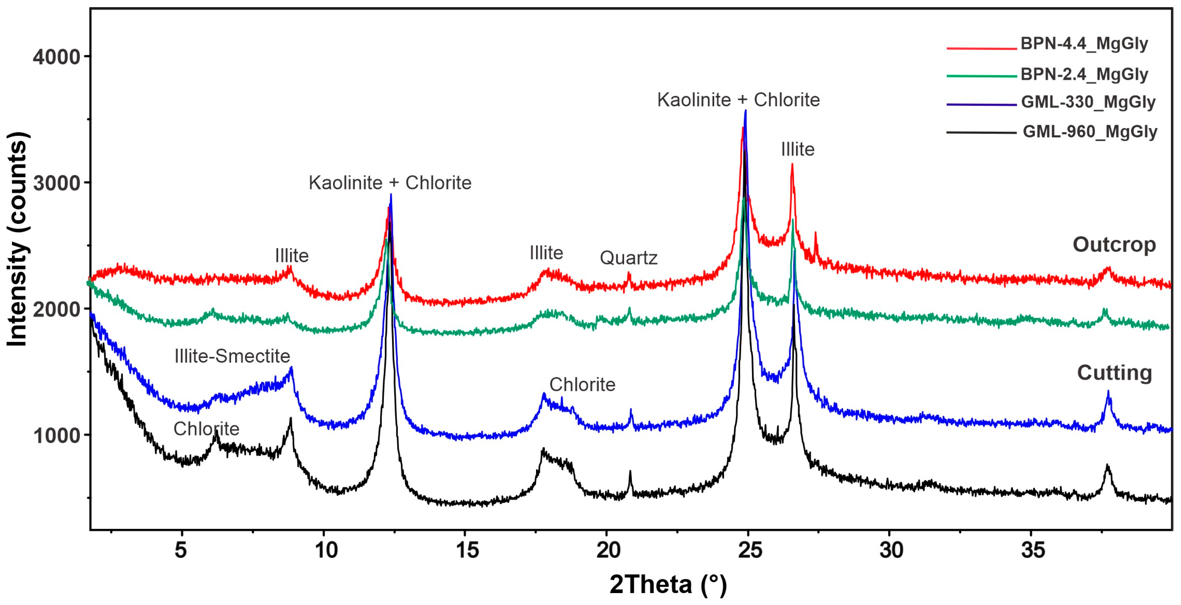
3.4. X-ray Diffraction (XRD)

The XRD analyses were carried out at the Department of Geology, University of Vienna, Austria. The mineralogical examination using X-ray diffraction comprised two phases. As part of the initial phase, bulk mineralogical analyses were conducted on thirteen mudstone samples using a Panalytical PW 3040/60 X’Pert PRO X-ray diffractometer with CuKα radiation (40 kV, 40 mA, step size 0.0167, 5 s per step). The second phase included the analysis of the clay fraction (<2 µm) in the fine-grained non-coal samples. For clay mineralogy analyses, two mudstone samples underwent cleaning and crushing, followed by treatment with H2O2 to eliminate organic matter. Subsequently, the samples were disaggregated using a 400 W ultrasonic probe for 3 min. The Atterberg cylinder sedimentation method was used to separate the clay size fraction (<2 µm) in (24 h 33 min). The clay fraction was dried at 60 °C and then saturated with K+ and Mg2+. Approximately 10 mg of the samples were dispersed in 1 mL of distilled water and placed on glass slides, drying overnight at room temperature. The oriented Mg- and K-samples were measured and subsequently saturated with ethylene glycol (EG) and glycerol (Gly) at 60 °C for 12 h. Additional K-samples were heated to 550 °C for 2 h. X-ray diffraction patterns obtained from the oriented mounts were qualitatively interpreted according to Brindley and Brown [20] and Moore and Reynolds [21]. The quantitative evaluation of X-ray patterns was performed using the Schultz [22] method.

4. Results

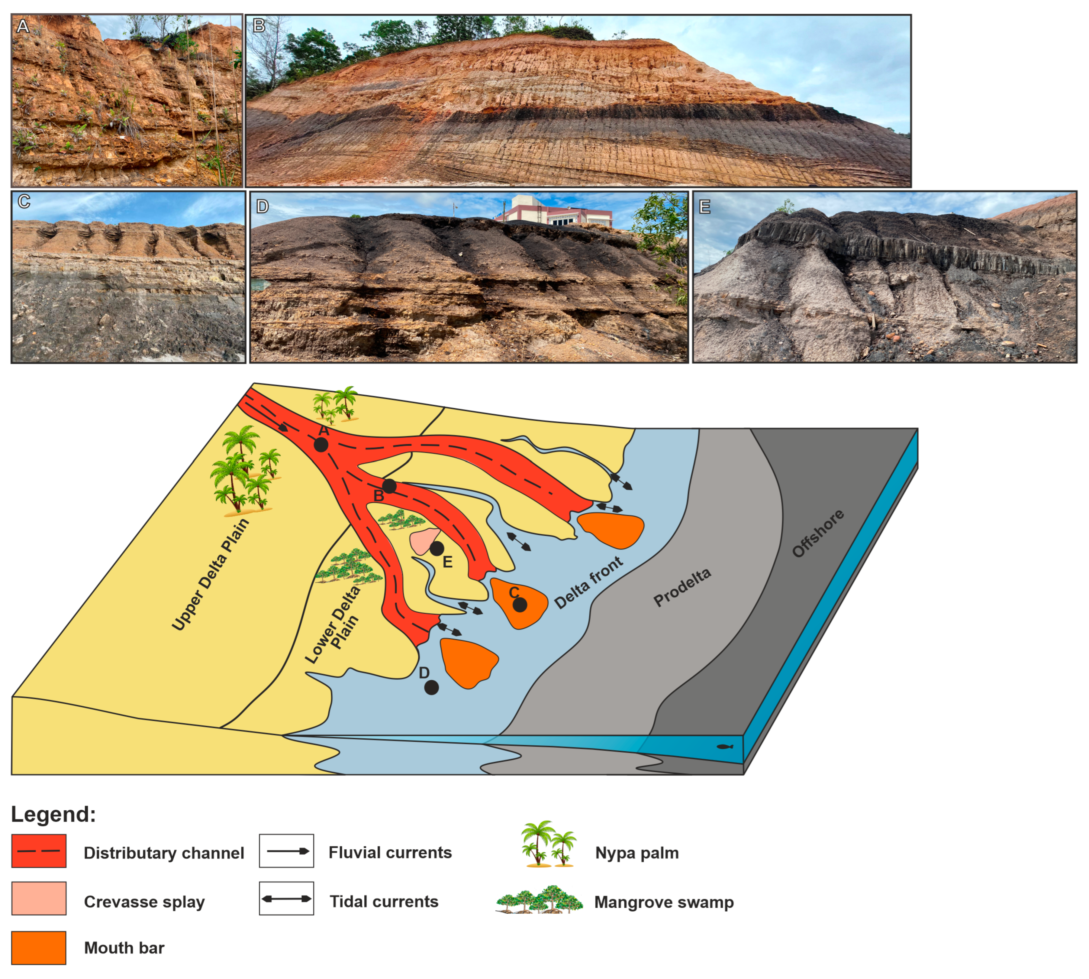
4.1. Lithofacies Characteristics

Eleven lithofacies were identified in the Kampungbaru Formation based on lithology (after [23]), texture, and sedimentary structures. Their characteristics are given in detail in Table 1 and are shown in Figure 2. The lithofacies include sandstone, siltstone, claystone, and coal. The spatial distribution of the lithofacies of the Kampungbaru Formation is shown in Figure 3, together with five vertical measured profiles from selected outcrops.
Sandstones are typically grey-white, beige-to-yellow, medium-to coarse-grained, moderately or well sorted, and are commonly friable (Figure 2A–E). Sedimentary structures observed in sandstones include cross-bedding, horizontal lamination, and ripple cross-lamination. Siltstone and claystone are characterized by beige, yellow-to-dark-grey, and black colors. They are commonly friable and exhibit lamination or have a massive appearance (Figure 2H,I). The fine-grained lithofacies are often interbedded with sandstone facies, forming heterolithics (Figure 2F,G). Dark-grey-to-black coal contains plant fragments and is often disintegrated (Figure 2J). Elsewhere, coal exhibits poorly developed lamination, very weak cleat-, or appears structureless.

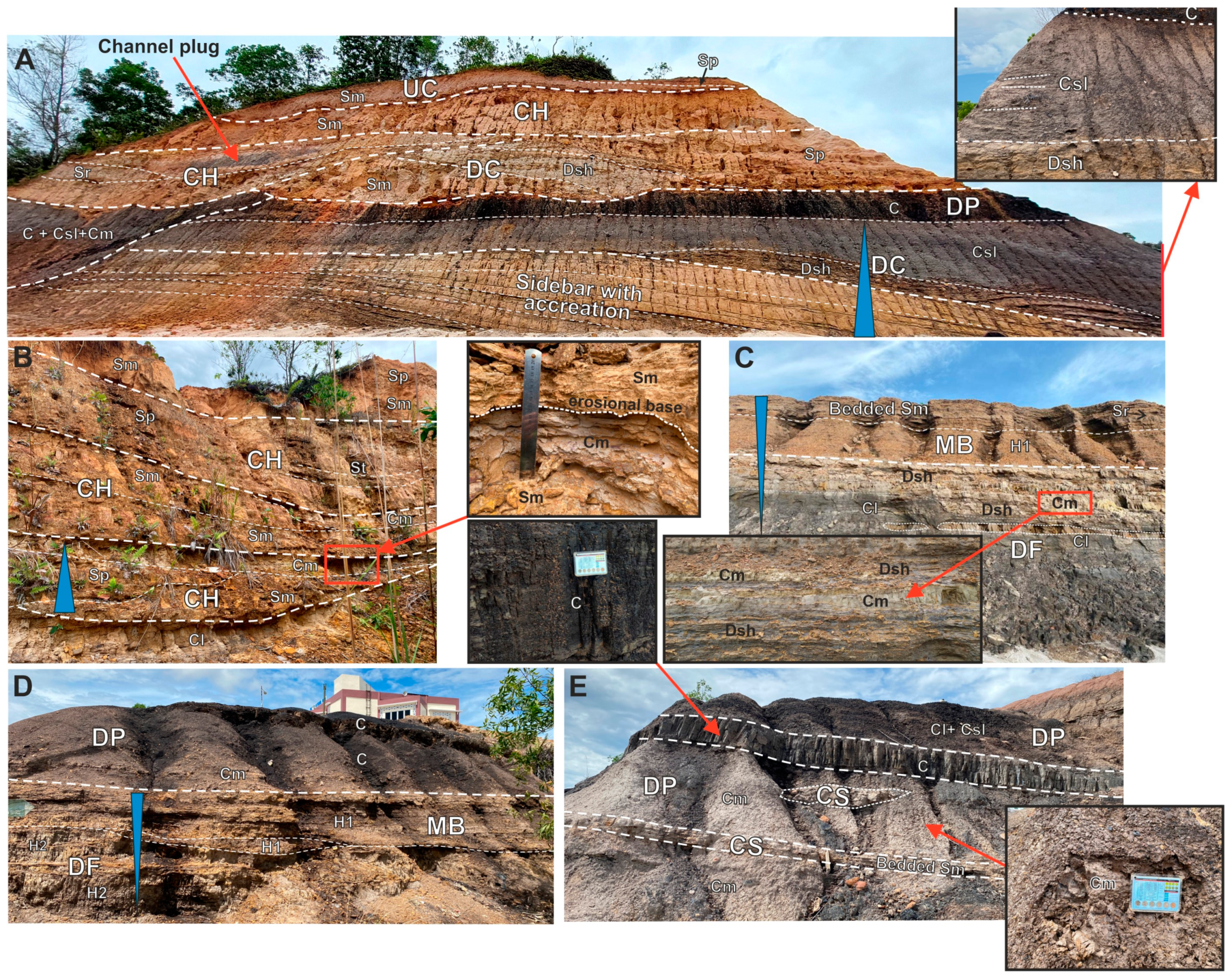
4.2. Facies Associations

Seven genetic facie associations were identified in the Kampungbaru Formation, namely the fluvial-dominated distributary channel, sheet-like sandstone, tide-influenced distributary channel, mouth bar, crevasse splay, delta plain, and delta front (Table 2 and Figure 4).

4.2.1. Fluvial-Dominated Distributary Channel Facies Association (CH)

This facies association includes c. 1–1.5 m thick sandstone bodies with concave-up and erosional bases (Figure 4A,B). Sandstone is medium to coarse-grained, has a massive appearance (facies Sm) or exhibits planar and trough cross-bedding (facies Sp and St). Massive sandstone occurs close to the base of the channel and passes vertically into cross-bedded sandstone. Asymmetrical ripples are found in the upper part of the channel fill (Sr). Successions exhibit a fining-upward trend; sandstone bed is locally capped by a layer of massive claystone. Sandstone bodies pass laterally into fine-grained facies elsewhere (Figure 4A). Channels are incised in massive or laminated claystone and coal beds (Figure 4A,B).
Interpretation: sandstones can be interpreted as deposits of the fluvial-dominated portion of distributary channels, most probably located on the upper delta plain (e.g., [32]). Uni-directional traction currents predominated in the channels that are often amalgamated. Fine-grained facies that are preserved in between the sandstones represent delta plain deposits or reflect channel abandonment.

4.2.2. Sheet-like Sandstone (UC)

This facies association represents a minor portion of all facies associations encountered in the study area. It is characterized by medium-grained massive sandstones (facies Sm) and sandstones with faint cross-bedding (facies Sp) (Figure 4A). The bases of sandstone beds are generally non-erosional and sharp, but they can also be slightly undulating in geometry and erosional (although not as profound as bychannel sandstones). These types of sandstone are laterally extensive, and c. 0.5 m thick.
Interpretation: These sandstones are interpreted to represent an unconfined fluvial flood event outside of the main channel on the delta plain [28,33].

4.2.3. Tide-Influenced Distributary Channel (DC)

This facies association consists of fine-to-medium-grained sandstones that exhibit planar cross-bedding or are massive (facies Sp and Sm). Mud intraclasts and coal fragments are commonly found at the base of sand bedforms. Massive sandstone is locally bioturbated and exhibits mottling. The sandstone bodies laterally extend for the first few tens of meters and are a few meters thick. In places, sandstone is vertically replaced by heterolithic facies, Dsh, and by massive or laminated claystone and silty claystone (Cm, Cl, and Csl). The entire succession is fining upward (Figure 4A). Heterolithic facies, Dsh, consists of horizontally or wavy laminated siltstones, sporadically occurring thinly bedded claystone and thicker beds of sandstone. Some channels are predominantly filled by fine-grained facies (claystone and siltstone). The color of the sediment vertically changes from beige-yellow to grey. Younger channels incise into older channels or are separated from them by fine-grained delta plain deposits. Some channel succession is overlain by coal bed.
Interpretation: The large-scale dipping cross-strata in the lower part of the outcrop in Figure 4A are interpreted as a result of the migration of a sand bar (?sidebar) in a distributary channel [34,35,36]. Smaller-scale sets of facies Sp represent dunes that migrate on the channel floor or on the top of the bar [37]. In general, large bedforms migrating down the distributary channel indicate fluvial dominance in the channel. Overlying heterolithic and fine-grained facies are interpreted as an indication of increasingly dominating tidal processes in distributary channels.

4.2.4. Mouth Bar (MB)

These facies association consists of massive sandstone (facies Sm), interbedded laminated very fine-to-medium-grained sandstone, siltstone and claystone (facies H1), and ripple cross-laminated sandstone (facies Sr). Very fine-to-medium-grained sandstones are generally well-sorted. Bed sets coarsen and thicken up in each section. Soft-sediment deformation is locally present.
Interpretation: Deposits of this facies are interpreted as mouth bar deposits. Predominant fine-grained sediments of facies H1 in Figure 4D are interpreted to represent a distal mouth bar, while heterolithic facies H1 and Dsh overlain by massive sandstone beds (Figure 4C) are interpreted as proximal mouth bar deposits. This association is closely related to delta front facies association and reflects tidal influence. Sedimentation changes from traction to suspension deposition with changing flow velocities.

4.2.5. Crevasse Splay

This facies association includes an isolated lenticular sandstone body and laterally extensive thinly bedded massive sandstone (facies Sm) fully encased in fine-grained sediments of delta plain sediments (Figure 4E).
Interpretation: Laterally extensive sand bodies of this facies are interpreted as crevasse splay deposits.

4.2.6. Delta Plain

Delta plain facies association comprises massive, laminated, and silty claystone (facies Cm, Cl, and Csl). They are commonly intercalated with coal beds and can reach several meters in thickness (Figure 4A,D,E). The color of fine-grained sediments of this association varies from beige to dark-grey. Coal is present in the form of variably thick laterally pervasive beds or as lenses. This association occurs interlayered with distributary channel and crevasse splay associations. Mud intraclasts and coal fragments are commonly found reworked in channel deposits. Bioturbation is generally rare and occurs in well-oxygenated sediments.
Interpretation: Beige claystone facies are interpreted to reflect a well-oxygenated upper delta plain. They are often interlayered with deposits of fluvial-dominated distributary channels. Grey-to-dark-grey fine-grained sediments interlayered with thick coal beds indicate suboxic-to-anoxic conditions developed on the lower delta plain. The presence of coal particularly indicates the development of peat bog in swampy areas, in which the accumulation and preservation of organic matter takes place.

4.2.7. Delta Front

This facies association is characterized by parallel bedding and lamination, heterolithic appearance, and the dominance of dark brown-to-light grey fine-grained facies Cl, Cm, and H1 (Figure 4D). Laminated claystone is interbedded with subordinate very fine-grained, mm to cm thick sandstone that forms thin discontinuous layers or lenses (wavy to lenticular bedding, mud drapes, facies H2). Bidirectional current ripples, possibly slightly wave-modified, are observed throughout the sections. Facies Dsh consists of thicker sandstone beds interbedded with siltstone, is up to 3 m thick, and has a lateral extent of ±13 m. This facies association is closely related to the mouth bar facies association and exhibits coarsening upwards. Bioturbation is rare.
Interpretation: This facies association is interpreted to reflect delta front deposition. The coarsening upwards and association with overlying mouth bar deposits indicates delta progradation. The abundance of heterolithic facies, mud drapes, and bidirectional current ripples points to significant tidal influence (Figure 4D). Reduced tidal influence and more significant fluvial input are interpreted for the generally sandier succession documented in Figure 4C (the upper part of the delta front succession, Dsh facies), possibly indicating proximal delta front environment.

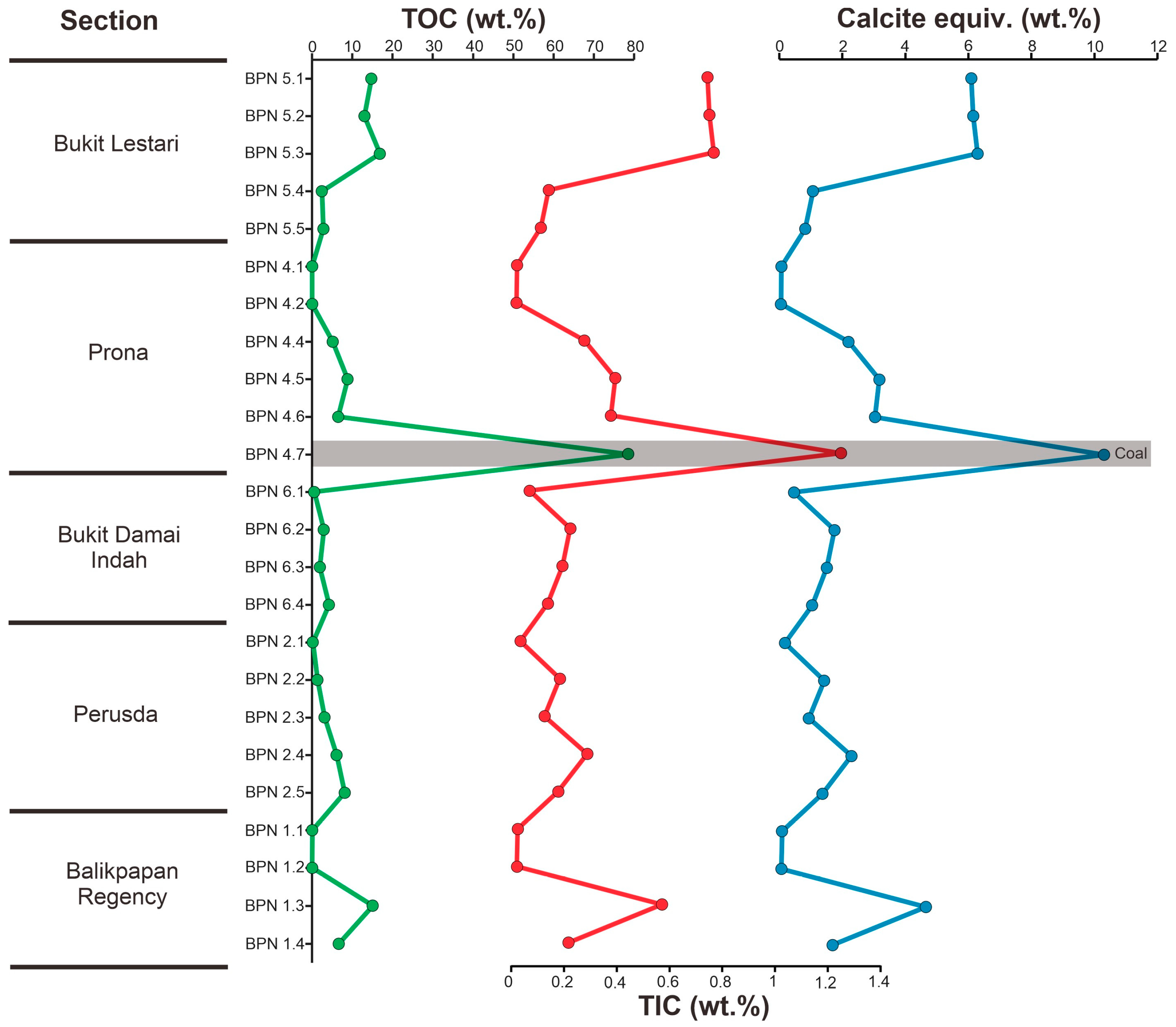
4.3. Leco Elemental Analysis

The studied Upper Miocene–Pliocene sedimentary rocks from the Kampungbaru Formation in the Lower Kutai Basin underwent analysis to determine several parameters, including total organic carbon (TOC), total inorganic carbon (TIC), and calcite equivalent. TOC levels were examined in both coal and non-coal samples, yielding a range between 5.14 and 16.87 of the weight percentage (wt.%) with an average of 10.11 wt.% for coal, and between 0.03 and 4.22 wt.% with an average of 1.54 wt.% for the fine-grained non-coal samples. The coal samples from the Prona section (sample BPN. 4.7) exhibited relatively high TOC values of 78.80 wt.%. Regarding TIC values, coal samples exhibited levels ranging from 0.16 to 1.24 wt.% with an average of 0.52 wt.%, while non-coal samples showed TIC values ranging from 0.01 to 0.21 wt.% with an average of 0.09 wt.%. Furthermore, the analysis also included the determination of the calcite equivalent with the maximum percentage observed in coals and intercalating sediments ranges between 10.31 and 1.75 wt.%, with average values of 4.30 and 0.73 wt.%, respectively. All samples in the Kampungbaru Formation have low carbonate contents (˂2 wt.% TIC, ˂15 wt.% Calcite equiv., Figure 5).

4.4. Organic Petrography

According to the maceral composition in the samples (Table 3), the dominant maceral group in these fine-grained non-coal and coal samples of the Kampungbaru Formation is vitrinite, followed by liptinite and inertinite. Fine-grained non-coal samples of the Kampungbaru Formation mainly consist of detrital clay-sized minerals with dominant vitrinite ranges from 71 to 79.6 vol.% (avg. 75.30 vol.%) (Figure 6A). The liptinite maceral present ranges from 16.90 to 27.4 vol.% (avg. 22.15 vol.%), and is dominated by the liptodetrinite submaceral (Figure 6B). Inertinite occurs in low percentages; it ranges from 1.5 to 3.50 vol.% (avg. 2.55 vol.%). A small amount of funginite from the inertinite group is also found (typically less than 1% of the total macerals and occurs as dispersed particles in the mineral matrix (Figure 6C). The Upper Miocene–Pliocene coal samples in the Kampungbaru Formation are dominated by the vitrinite maceral group with values between 60.7 and 84.6 vol.% with an average of 72.65 vol.% and commonly contain subordinate textinite associated with cutinite (Figure 6D). The liptinite content in the studied samples ranges from 9.8 to 27.5 vol.% (avg. 18.65 vol.%), and the most abundant liptinites were dominated by cutinite. In situ resinite is the most common form in the Balikpapan area and can be classified into primary resinite and secondary resinite (Figure 6D). Suberinite occurs in minor amounts (avg. 2.5 vol.%) with greenish-yellow-to-orange fluorescence (Figure 6E). The inertinite group is very low in the studied samples, ranging from 5.60 to 11.8 vol.% (avg. 8.7 vol.%) and is predominantly represented by funginite and cells filled with exsudatinite (Figure 6F).

4.5. Mineralogical Characterization

4.5.1. Bulk Mineralogy

Semi-quantitative XRD results of 14 mudstone samples include varying proportions of clay and non-clay minerals. Quartz was identified by reflections at 1.81 Å, 2.28 Å, 2.47 Å, 3.34 Å, and 4.26 Å. Pyrite was determined at 1.91 Å, 2.42 Å, 2.70 Å. Clay minerals, including kaolinite and illite, were determined at 1.50 Å, 1.67 Å, 2.56 Å, 3.24 Å, 3.59 Å, and 7.18 Å (Figure 7). The fine-grained non-coal samples are dominated by clay minerals (33.4–63.0%, avg. = 47%), quartz (23.8–60.5%, avg. = 37%), and pyrite (6.0–32.4%, avg. = 16%). The semi-quantitative mineral analyses are shown in Table 4.

4.5.2. Clay Mineralogy (<2 μm Fraction)

Representative XRD patterns of air-dried Mg- and K-saturated, glycerol (Gly)-treated and heated samples are shown in Figure 8. The results of the clay fraction mineral analyses of the non-coal samples show that the most abundant clay minerals are illite, kaolinite, chlorite, and also mixed-layer illite/smectite (I/S). Illite is recognized by its 3.33 Å, 4.95 Å, and 9.89 Å peaks. Chlorite is distinguished by its 3.56 Å, 4.90 Å, and 7.15 Å peaks, while kaolinite is identified by its characteristic peaks of 3.56 Å and 7.15 Å. Illite/smectite-mixed and layered clay minerals were identified by the peak at 12 Å in the Mg-saturated sample that changed its position to 13–14 Å in the ethylene-glycol (EG) and Gly-saturated samples. Based on clay analysis, kaolinite (30–41%) and mixed-layer illite/smectite (I/S) (32–42%) are the most prevalent clay minerals, followed by illite (23%) and rare chlorite (2–4%).

5. Discussion

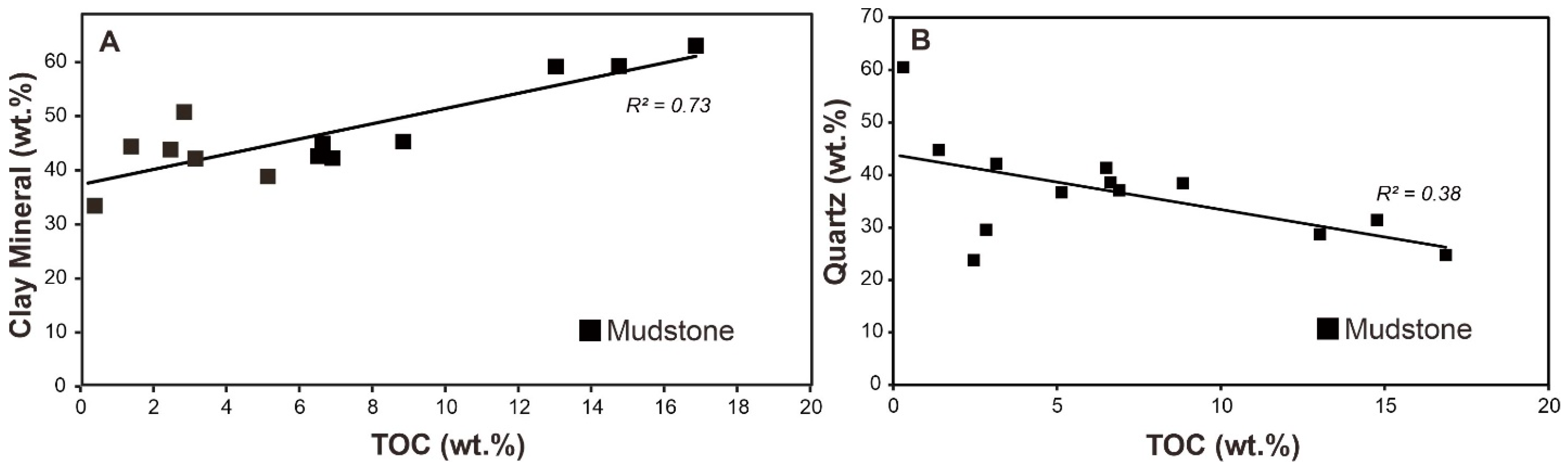
5.1. Organic Matter and Mineral Characteristics

Hydrocarbon generation is primarily linked to the type of organic matter present in the rocks with the quantity of hydrocarbons generated while being influenced by the abundance of organic matter [41,42]. The origin of organic matter in the fine-grained non-coal and coal samples from the study area indicates a terrestrial source predominantly derived from materials such as bark, wood, and leaves [5]. The organic matter accumulation in the Kampungbaru Formation is, thus, interpreted to be primarily associated with a lower delta plain environment covered by Nypa palms and mangrove swamps. The accumulation of plant remains in this environment is influenced by tides, where materials are reworked and separated. Unstable degraded products are winnowed out with fine sediments enriched in organic matter. Coarse shore-zone accumulations, despite retaining a significant number of degraded products, are buried by sediments and transformed into lignite. The processes of burial, compaction, and slow maturation contribute to the generation of hydrocarbons from the organic materials in these sedimentary rocks [43,44,45].
Samples from the Kampungbaru Formation consistently exhibit low carbonate contents, characterized by TIC levels below 2 wt.% and calcite equivalent percentages below 15 wt.%. This uniformity in carbonate content suggests a prevailing trend of limited carbonate mineralization within the formation across all sampled lithological units. Such findings provide valuable insights into the geochemical composition of the Kampungbaru Formation, indicating a predominantly non-carbonate depositional environment and shedding light on the sedimentary processes and diagenetic pathways that have influenced the formation’s evolution within the geological context of the study area.
Based on the petrographic analyses conducted on both the fine-grained non-coal and coal samples derived from the Kampungbaru Formation, it is evident that all samples exhibit a notable abundance of vitrinite, alongside a prevalent presence of liptinite and minor amounts of inertinite (Figure 9 and Table 3). Mineral components comprising predominantly clay and pyrite were identified within the samples. The presence of pyrite can be attributed to the activity of sulfate-reducing bacteria within a reducing environment [46]. In such environments where organic matter preservation is facilitated, pyrite formation occurs as a result of the bacterial action on sulfate ions. This association highlights the significance of reducing conditions in preserving organic matter, thus contributing to the observed high vitrinite content and the common presence of liptinite within the Kampungbaru Formation samples. The ternary plot, as proposed by Cornford [47], serves as a classification tool for determining the type of kerogen present within a sample based on its petrographic constituents. Specifically, the type of organic matter observed under reflected light microscopy indicates a predominant presence of type III kerogen, as illustrated in Figure 9. This classification suggests that the organic matter within the sample exhibits characteristics associated with type III kerogen, which typically indicates a high proportion of terrestrial organic material derived from land plants.
The maceral analysis of the samples in the study area suggests, in general, a close association between the organic matter and the coal beds, as the concentration of organic matter is notably higher within the coal-bearing intervals of each section. The presence of significant quantities of organic matter in the Balikpapan area is linked to the coal-rich intervals within the formations. Both the continuous distribution of coal seams, as well as the thin coal laminae and coaly fragments in the non-coals, demonstrate the continuous strong input of higher plants. The high vitrinite content derived from woody tissue is similar to the typical arboreal vegetation in most tropical peats in Indo-Malaysian swamps. In Neogene coal, the proportions of liptinite and inertinite demonstrate a systematic relationship with the vitrinite content. Specifically, as the vitrinite content increases, there is a corresponding decrease in the proportions of both liptinite and inertinite. This inverse correlation indicates a consistent trend wherein a higher vitrinite content is associated with lower levels of liptinite and inertinite within the coal samples [48,49,50].
The total organic carbon (TOC) content exhibits a positive correlation with clay mineral content (r2 = 0.73) (Figure 10A) while displaying a negative correlation with quartz content (r2 = 0.38) within the organic-rich non-coal (Figure 10B) samples. The quartz present in organic-rich non-coal samples primarily originates from clastic material and often demonstrates a waxing and waning pattern in association with clay minerals. Clay minerals possess the capability to adsorb significant amounts of organic matter, leading to the formation of stable organic–clay complexes. A clear inverse linear correlation between quartz and TOC exists, confirming that terrigenous mineral input can significantly dilute organic matter concentrations. The negative correlation observed between TOC and quartz content can be attributed to the adsorption and stabilization of organic matter by clay minerals, which facilitates its accumulation and preservation. Conversely, the positive correlation between TOC and clay mineral content highlights the role of clay minerals in promoting organic matter retention within the sedimentary matrix.

5.2. Paleoclimate Condition

The clay mineralogical composition of sediments provides valuable insights into paleoenvironmental conditions, such as the climate, sea level fluctuations, and tectonic activity. The composition of clay minerals serves as a valuable indicator of weathering intensity, specifically the degree of hydrolysis, in a source area [51]. The interpretation of paleoclimatic data from clay minerals necessitates an understanding of the potential source areas [52,53] and the modes and strengths of transport processes [54,55]. Variable concentrations of clay minerals in sediments are commonly utilized as a reliable proxy to trace climate changes between arid and humid conditions due to their distinct detrital origin [56].
Today, the East Kalimantan study region is characterized by a humid climate, as evidenced by rainfall data collected at Balikpapan (1°16′ S) [57]. The entire region is covered by tropical rainforests (Af classification according to [58]), and the majority of it is underlain by Cenozoic sedimentary rocks. Rivers originating from the highlands of central Borneo in East Kalimantan flow into the Makassar Strait. Despite the modern Mahakam River Delta potentially being sediment-starved, substantial sediment deposits have been historically transported. Several explanations exist regarding the origin of sediments in the delta. One possibility is that the Mahakam River cut into and eroded the Cenozoic fold belt as tectonic uplift progressed between the contemporary Kutai Basin and the coastline [59]. This process of downcutting and erosion, occurring over a downstream distance of 100 km, would have generated a considerable amount of sediment. The supply of sediments was, thus, controlled by the interplay between ongoing tectonics and the climate, which may have played a secondary role. As most of the sediment deposited in the Mahakam Delta likely originates from erosion by the antecedent part of the Mahakam River, further evaluation of the sediment’s source and discharge variations is necessary [60].
Detailed clay mineralogical analyses of outcrop data from the Kampungbaru Formation (this study) and subsurface well cuttings data from the Sanga-Sanga Block [7] show that the clay mineral data in surface and subsurface samples are similar, consisting of kaolinite, illite, chlorite and mixed-layer illite/smectite (I/S) (Figure 11). Non-coal samples from the Kampungbaru Formation exhibit a consistent clay mineral composition comprising kaolinite, mixed-layer illite/smectite (I/S), illite, and chlorite (Figure 11). Kaolinite, formed by the monosialitization of parent rocks, is the predominant clay mineral, indicating intensive hydrolysis under a warm and humid climate. The presence of kaolinite suggests warm temperatures, and its association with humid conditions indicates a climate with abundant rainfall. The mixed layer mineral illite/smectite (I/S) is interpreted to reflect varying climatic conditions and possibly seasonal changes with warmer and wetter conditions, followed by cooler and drier intervals.
The paleoclimate during the deposition of the Kampungbaru Formation can also be further inferred from the types of sediments and preserved organic matter. The fluvio-deltaic clastic sediments interlayered with common coal beds indicate that the studied region likely experienced a warm and humid climate during the Upper Miocene–Pliocene period. Moreover, the coal samples from the Kampungbaru Formation are characterized by a dominant vitrinite maceral group (Figure 6) with values between 17 and 42.5 vol.% (with an average of 29.75 vol.%). These findings suggest that the region was covered by abundant vegetation during the Upper Miocene–Pliocene period, just like today, further pointing to a warm and humid climate at the time of the deposition. The climate-controlled the growth of plants, which can be interpreted as a main source of organic matter in the formation. The coal deposits found in the outcrops originated mainly from terrestrial organic material, such as higher plants and trees, which accumulated in low-energy, waterlogged settings within the deltaic system. It is very likely that a warm and humid climate, together with ongoing tectonic activity in the basin, controlled high terrigenous clastic influx during the deposition of the Kampungbaru Formation. The evaluation of tectonic activity in the basin and its significance is, however, beyond the scope of this study. Nevertheless, according to some authors [4], the Kampungbaru Formation lies unconformably above the Balikpapan Formation, further supporting active tectonics in the Kutai Basin.

5.3. Depositional Environments

The analysis and interpretation of lithofacies associations have led to a better understating of the depositional environment of the Kampungbaru Formation in the Balikpapan area. Well- to medium-sorted sandstones, siltstones, and claystones, with their sedimentary structures and external and internal geometries, suggest a deltaic environment. The defined facies associations helped to differentiate between individual sub-environments, such as distributary channels, the delta plain with swampy areas, and the delta front. The channels, which exhibit fluvial dominance, are interpreted to occur within the upper delta plain. Fluvial-dominated distributary channel successions consist of thick (0.5 m to several meters), locally amalgamated sand bodies interbedded with thin claystone or siltstone beds and often do not interlay with coal beds (Figure 12A). Coal beds are more frequently interbedded with sediments of tide-influenced distributary channels (Figure 12B). Bidirectional current ripples, mud drapes, and wavy and lenticular beddings suggest tidal influence within distributary channels that were located on a lower delta plain covered with peat bogs and swamps. Distributary channels and rarely encountered out-of-channel unconfined flows represent high-energy environments associated with predominant sandstone deposition, while delta plain siltstones and claystone reflect low-energy settings, only locally disrupted by sandstone bodies of crevasse splay origin. The channel amalgamation, which is described only from the upper portions of the distributary channel (Figure 12A), could reflect a lower A/S ratio, increased fluvial sediment discharge, or high sedimentation rate. In the lower portion of the fluvial/deltaic system, channels are commonly isolated and do not show amalgamation. For comparison, Snedden et al. [61] concluded that the Upper Miocene Mahakam Deltaic sediments reflect increased sediment supply and high subsidence.
The identified facies associations in the Upper Miocene–Pliocene successions suggest a dynamic and complex deltaic system. Cross-stratified sandstones provide evidence of bedforms that migrated down the channel and indicate fluvial dominance and active sediment transport within the delta. Tidal influence that is mostly observed in the lower portions of the channels interacted with decreasing fluvial processes. In general, fluvial-dominated distributary channels exhibit a higher ratio between sand and shale when compared to tide-influenced distributary channels. Coal fragments are commonly found at the erosional channel bases, indicating the erosion and reworking of coal deposits on the delta plain and, to some degree, lateral channel migration. Interdistributary areas are characterized by fine-grained sediments interlayered with thick coal beds (Figure 12E). Increasing tide and also, to some degree, wave influence is observed in the delta front area dominated by fine-grained sediments. Associated mouth bars are dominated by sandstones that are interbedded with fine-grained facies and also record tidal influence (Figure 12C,D).
The sediments of the Kampungbaru Formation are interpreted as predominantly deltaic deposits with marine influence. The sedimentary facies, structures, and external and internal geometries of the studied successions and sedimentary bodies allowed to conclude that the Upper Miocene to Pliocene delta was influenced by both fluvial and tide processes, similar to the recent Mahakam Delta. The Kampungbaru Formation consists of thick, well-sorted laterally extending distributary channel sandstones, which could serve as a reservoir rock. Nevertheless, further studies are needed to determine specific reservoir properties, such as porosity and permeability. Organic, rich, fine-grained sediments of the lower delta plain, interbedded with thick coal beds, could form a source rock.

6. Conclusions

Based on sedimentology, bulk geochemistry, organic petrography, and the mineralogy of the Kampungbaru Formation, the paleoenvironmental and paleoclimatic conditions and their impact on the accumulation of organic matter were examined.
  • Eleven lithofacies were identified and further grouped into seven facies associations as follows: the fluvial-dominated distributary channel (CH), sheet-like sandstone (UC), tide-influenced distributary channel (DC), crevasse splay (CS), mouth bar (MB), delta plain (DP) and delta front (DF). Sediments of the Kampungbaru Formation reflect deposition in a deltaic environment by predominant fluvial and subordinate tidal processes.
  • The paleoclimate during deposition of the Upper Miocene and Pliocene Kampungbaru Formation was generally warm and humid, as evidenced by the dominance of the vitrinite maceral group. High proportions of vitrinite in the coals indicate that the original plant material consisted essentially of woody plant tissue, and peatification occurred under relatively wet-reducing conditions.
  • Clay mineral analysis revealed the predominance of kaolinite and mixed-layer I/S supporting further warm and humid climate conditions during the deposition of the formation.

Author Contributions

Conceptualization, J.; methodology, K.S., M. and S.G.; validation, J., K.S. and M.W.; formal analysis, J.; investigation, J., M. and K.S.; data curation, J., M. and D.F.; writing—original draft preparation, J.; writing—review and editing, J., K.S., S.G., D.F. and M.W; visualization, J. and K.S.; Supervision, M.W. and K.S. All authors have read and agreed to the published version of the manuscript.

Funding

This research was funded by the Ministry of Education and Culture of Indonesia and Austrian Agency for International Cooperation in Education and Research (OeAD GmbH): MPC-2020-01344. Open access was funded by the University of Vienna. Support by UNESCO IGCP 732 and Austrian Academy of Sciences, International Programs, is acknowledged.

Data Availability Statement

The original contributions presented in the study are included in the article: further inquiries can be directed to the corresponding author.

Acknowledgments

The authors wish to thank Montanuniversität Leoben for their support, especially Reinhard Sachsenhofer and Hafidz Noor Fikri on organic petrography. We thank two anonymous reviewers who provided insightful comments that helped to improve this manuscript.

Conflicts of Interest

The authors declare no conflicts of interest.

References

  1. Demaison, G.J.; Moore, G.T. Anoxic environments and oil source bed genesis. Org. Geochem. 1980, 2, 9–31. [Google Scholar] [CrossRef]
  2. Sia, S.G.; Abdullah, W.H. Geochemical and petrographical characteristics of low-rank Balingian coal from Sarawak, Malaysia: Its implications on depositional conditions and thermal maturity. Int. J. Coal Geol 2012, 96–97, 22–38. [Google Scholar] [CrossRef]
  3. Fathy, D.; Baniasad, A.; Littke, R.; Sami, M. Tracing the geochemical imprints of Maastrichtian black shales in southern Tethys, Egypt: Assessing hydrocarbon source potential and environmental signatures. Int. J. Coal Geol. 2024, 283, 104457. [Google Scholar] [CrossRef]
  4. Permana, A.K.; Sendjadja, Y.A.; Panggabean, H.; Fauxely, L. Depositional Environment and Source Rocks Potential of the Miocene Organic-Rich Sediments, Balikpapan Formation, East Kutai Sub-Basin, Kalimantan. J. Geol. Miner. Resour. 2018, 9, 171–186. [Google Scholar]
  5. Jamaluddin; Wagreich, M.; Gier, S.; Schöpfer, K.; Battu, D.P. Sedimentary Environments and Paleoclimate Control of the Middle Miocene Balikpapan Group, Lower Kutai Basin (Indonesia): Implications for Evaluation of the Hydrocarbon Potential. Minerals 2023, 13, 1259. [Google Scholar] [CrossRef]
  6. Widodo, S.; Bechtel, A.; Anggayana, K.; Püttmann, W. Reconstruction of floral changes during deposition of the Miocene Embalut coal from Kutai Basin, Mahakam Delta, East Kalimantan, Indonesia by use of aromatic hydrocarbon composition and stable carbon isotope ratios of organic matter. Org. Geochem. 2009, 40, 206–218. [Google Scholar] [CrossRef]
  7. Marks, E.B.; Sujatmiko, S.L.; Dhanutirto, H.; Ismoyowati, T.; Sidik, B. Cenozoic Stratigraphic Nomenclature in East Kutai Basin, Kalimantan. In Proceedings of the 11th Annual Convention Proceedings, Jakarta, Indonesia, 18–20 October 1982; Indonesian Petroleum Association: Jakarta, Indonesia, 1982. [Google Scholar]
  8. Sherwood, P.; Algar, S.; Goffey, G.; Busono, I.; Fowler, J.N.; Francois, J.; Smith, M.J.; Strong, A. Comparison of recent and Mio-Pliocene deep-water deposits in the Kutai Basin, East Kalimantan. In Proceedings of the Indonesian Petroleum Association 28th Annual Convention and Exhibition, 24–26 October 2001; Volume 1, pp. 423–438. [Google Scholar]
  9. Rohmana, R.C.; Fardiansyah, I.; Taufani, L.; Harishidayat, D. Depositional processes and facies architecture of Balikpapan sandstone formation, application of 3D Digital Outcrop Model (DOM) to identify reservoir geometry and distribution in deltaic system. Sci. Contrib. Oil Gas 2019, 42, 35–42. [Google Scholar] [CrossRef]
  10. Cibaj, I.; Syarifuddin, N.; Ashari, U.; Wiweko, A.; Maryunani, K.A. Stratigraphic Interpretation of Middle Miocene Mahakam Delta Deposits: Implications for Reservoir Distribution and Quality. In Proceedings of the Indonesian Petroleum Association, the 31st Annual Convention, Jakarta, Indonesia, 14–16 May 2007. [Google Scholar]
  11. Cibaj, I. Channel—Levee Complexes in a Slope Turbidite Series of Lower Kutei Basin, East Kalimantan. In Proceedings of the Indonesian Petroleum Association, 35th Annual Convention, Jakarta, Indonesia, 18–20 May 2011. [Google Scholar]
  12. Cibaj, I.; Lambert, B.; Zaugg, P.; Ashari, U.; Dal, J.-A.; Imbert, P. Stratigraphic Stacking Patterns of the Mahakam Area, LowerKutei Basin, East Kalimantan, Indonesia. In Proceedings of the Indonesian Petroleum Association, 38th Annual Convention, Jakarta, Indonesia, 21–23 May 2014. [Google Scholar]
  13. Moss, S.J.; Chambers, J.L.C.; Cloke, J.R.; Satria, D.; Ali, J. New observations on the sedimentary and tectonic evolution of the Tertiary Kutei Basin, East Kalimantan. Geol. Soc. Lond. 1997, 126, 395–416. [Google Scholar] [CrossRef]
  14. Hidayat, S.; Umar, I. Peta Geologi Lembar Balikpapan, Kalimantan; Skala 1:250.000; Direktorat Geologi: Bandung, Indonesia, 1994. [Google Scholar]
  15. Satyana, A.H.; Nugroho, D.; Surantoko, I. Tectonic controls on the hydrocarbon habitats of the Barito, Kutei, and Tarakan Basins, Eastern Kalimantan, Indonesia: Major dissimilarities in adjoining basins. J. Asian Earth Sci. 1999, 17, 99–122. [Google Scholar] [CrossRef]
  16. Hall, R.; Nichols, G. Cenozoic sedimentation and tectonics in Borneo: Climatic influences on orogenesis. In Sediment Fluxto Basins: Causes, Controls and Consequences; Jones, S.J., Frostick, L., Eds.; Geological Society of London: London, UK, 2002; Volume 191, pp. 5–22. [Google Scholar] [CrossRef]
  17. ICCP. The new vitrinite classification (ICCP System 1994). Fuel 1998, 77, 349–358. [Google Scholar] [CrossRef]
  18. ICCP (International Committee for Coal and Organic Petrology). The new inertinite classification (ICCP System 1994). Fuel 2001, 80, 459–471. [Google Scholar] [CrossRef]
  19. Pickel, W.; Kus, J.; Flores, D.; Kalaitzidis, S.; Christanis, K.; Cardott, B.J.; Misz-Kennan, M.; Rodrigues, S.; Hentschel, A.; Hamor-Vido, M.; et al. Classification of liptinite—ICCP System 1994. Int. J. Coal Geol. 2017, 169, 40–61. [Google Scholar] [CrossRef]
  20. Brown, G.; Brindley, G.W. X-ray Diffraction Procedures for Clay Mineral Identification. In Crystal Structures of Clay Minerals and Their X-ray Identification; Brindley, G.W., Brown, G., Eds.; Mineralogical Society of Great Britain and Ireland: London, UK, 1980; Volume 5. [Google Scholar]
  21. Moore, D.M.; Reynolds, R.C., Jr. X-ray Diffraction and the Identification and Analysis of Clay Minerals; Oxford University Press (OUP): Oxford, UK, 1989. [Google Scholar]
  22. Schultz, L.G. Quantitative Interpretation of Mineralogical Composition from X-ray and Chemical Data for the Pierre Shale; US Geological Survey Professional Paper 391-C; U.S. Government Printing Office: Washington, DC, USA, 1964.
  23. Wentworth, C.K. A scale of grade and class terms for clastic sediments. J. Geol. 1922, 30, 377–392. [Google Scholar] [CrossRef]
  24. Miall, A.D. Reconstructing fluvial macroform architecture from Two dimensional outcrops: Examples from the Castlegate Sandstone, Book Cliffs, Utah. J. Sediment. Res. 1994, 64, 146–158. [Google Scholar]
  25. Collinson, J.D.; Mountney, N.P. Sedimentary Structures; Dunedin Academic Press: Edinburgh, UK, 2019; p. 340. [Google Scholar]
  26. Allen, J.R.L. Studies in fluviatile sedimentation: Bars, bar complexes and sandstone sheets (low-sinuosity braided streams) in the Brownstones (Lower Devonian), Welsh Borders. Sediment. Geol. 1983, 33, 237–293. [Google Scholar] [CrossRef]
  27. Celis, S.A.; Rodríguez-Tovar, F.J.; Giraldo-Villegas, C.A.; Pardo-Trujillo, A. Evolution of a fluvial-dominated delta during the Oligocene of the Colombian Caribbean: Sedimentological and ichnological signatures in well-cores. J. S. Am. Earth Sci. 2021, 111, 103440. [Google Scholar] [CrossRef]
  28. Collinson, J.; Mounney, J.N.; Thompson, D. Sedimentary Structures, 3rd ed.; Terra Publishing: Middlesex, UK, 2006; p. 292. [Google Scholar]
  29. Bridge, J.S. Rivers and Floodplains: Forms, Processes, and Sedimentary Record; Blackwell: Oxford, UK, 2003; p. 491. [Google Scholar]
  30. Bridge, J.S. Fluvial facies models: Recent developments. In Facies Models Revisited; Posamentier, H.W., Walker, R.G., Eds.; SEPM Special Publications: Claremore, OK, USA, 2006; Volume 84, pp. 85–170. [Google Scholar] [CrossRef]
  31. Alam, F.; Sebayang, Y.; Djunarjanto, W.; Prijanto, P.E. Coal Stratigraphy of Separi, East Kalimantan, Indonesia. In Proceedings of the Masyarakat Geologi Ekonomi Indonesia (MGEI)—Ikatan Ahli Geologi Indonesia (IAGI), Balikpapan, Indonesia, 29–30 March 2010. [Google Scholar]
  32. Reading, H.G.; Collinson, J.D. Clastic Coasts. Sedimentary Environments: Processes, Facies and Stratigraphy; Blackwells: Cornwall, UK, 1996; pp. 154–231. [Google Scholar]
  33. Medici, G.; Boulesteix, K.; Mountney, N.P.; West, L.J.; Odling, N.E. Palaeoenvironment of braided fluvial systems in different tectonic realms of the Triassic Sherwood Sandstone Group, UK. Sediment. Geol. 2015, 329, 188–210. [Google Scholar] [CrossRef]
  34. El Yakouti, I.; El Asmi, H.; Gourari, L.; Benabbou, M.; Hayati, A.; Salah, M.; Chellai, E.H. Facies analysis, architectural elements, and paleoenvironmental reconstruction of alluvial deposits of the low terraces and floodplains in the Middle Sebou river (Eastern Saïss foreland basin, Morocco). J. Afr. Earth Sci. 2024, 211, 105170. [Google Scholar] [CrossRef]
  35. Bridge, J.S. Description and Interpretation of fluvial deposits: A critique perspective. Sedimentology 1993, 40, 801–810. [Google Scholar] [CrossRef]
  36. Payenberg, T.H.D.; Lang, S.C. Reservoir geometry of fluvial distributary channels—Implications for Northwest Shelf, Australia, deltaic successions. APPEA J. 2003, 43, 325–338. [Google Scholar] [CrossRef]
  37. Miall, A.D. The Geology of Fluvial Deposits; Springer: Berlin/Heidelberg, Germany, 1996; p. 582. [Google Scholar]
  38. Olariu, C.; Bhattacharya, J.P. Terminal distributary channels and delta front architecture of river-dominated delta systems. J. Sediment. Res. 2006, 76, 212–233. [Google Scholar] [CrossRef]
  39. Aschoff, J.L.; Olariu, C.; Steel, R.J. Recognition and significanceof bayhead delta deposits in the rock record: A comparison ofmodern and ancient systems. Sedimentology 2018, 65, 62–95. [Google Scholar] [CrossRef]
  40. Allen, J.R.L. Sediments of the modern Niger Delta. In Deltaic Sedimentation: Modern and Ancient; Society of. Economic Paleontologists and Mineralogists; Morgan, J.P., Ed.; SEPM Special Publications: Claremore, OK, USA, 1970; Volume 15, pp. 138–151. [Google Scholar] [CrossRef]
  41. Petersen, H.I. The petroleum generation potential and effective oil window of humic coals related to coal composition and age. Int. J. Coal Geol. 2006, 67, 221–248. [Google Scholar] [CrossRef]
  42. Ayinla, H.A.; Abdullah, W.H.; Makeen, Y.M. Source rock characteristics, depositional setting and hydrocarbon generation potential of cretaceous coals and organic rich mudstones from Gombe Formation, Gongola Sub-basin, Northern Benue Trough. NE Nigeria. Int. J. Coal Geol. 2017, 173, 212–226. [Google Scholar] [CrossRef]
  43. Combaz, A.; de Matharel, M. Organic sedimentation and genesis of petroleum in Mahakam delta, Borneo. Am. Assoc. Pet. Geol. Bull. 2006, 62, 1684–1695. [Google Scholar] [CrossRef]
  44. Yuniardi, Y. Petroleum System Cekungan Kutai Bagian Bawah, Daerah Balikpapan dan Sekitarnya, Provinsi Kalimantan Timur. Bull. Sci. Contr. 2012, 10, 42–57. [Google Scholar]
  45. Jamaluddin; Michael, W.; Xiang, X.; Umar, E.P. Organic geochemical characterization of Miocene shale in Lower Kutai Basin, East Kalimantan, Indonesia. In Proceedings of the PANGEO, Leoben, Austria, 10–13 September 2022. [Google Scholar]
  46. Morse, J.W.; Wang, Q. Pyrite formation under conditions approximating those in anoxic sediments: II. Influence of precursor iron minerals and organic matter. Mar. Chem. 1997, 57, 187–193. [Google Scholar] [CrossRef]
  47. Cornford, C. Organic deposition at a continental rise: Organic geochemical interpretation and synthesis at DSDP Site 397, eastern North Atlantic. In Initial Reports; DSDP, 47 Part 1; Von Rad, U., Ryan, W.B.E., Arthur, M.A., Cepek, P., Cita, M.B., Cornford, C., Garifal, L., Hamilton, N., Lopatin, B., Lutze, G.F., et al., Eds.; U.S. Government Printing Office: Washington, DC, USA, 1979; pp. 503–510. [Google Scholar]
  48. Santoso, B.; Daulay, B. Significance of type and rank of selected Kutai coals with respect to their utilization characteristics. Indones. Min. J. 2005, 8, 1–12. [Google Scholar]
  49. Belkin, H.E.; Tewalt, S.J.; Hower, J.C.; Stucker, J.D.; O’Keefe, J.M.K. Geochemistry and petrology of selected coal samples from Sumatra, Kalimantan, Sulawesi, and Papua, Indonesia. Int. J. Coal Geol. 2009, 77, 260–268. [Google Scholar] [CrossRef]
  50. Daulay, B.; Santoso, B.; Ningrum, N.S. Evaluation of selected high rank coal in Kutai Basin, East Kalimantan relating to its coking properties. Indones. Min. J. 2015, 18, 1–10. [Google Scholar]
  51. Dera, G.; Pellenard, P.; Neige, P.; Deconinck, J.F.; Pucéat, E.; Dommergues, J.L. Distribution of clay minerals in Early Jurassic Peritethyan seas: Palaeoclimatic significance inferred from multiproxy comparisons. Palaeogeogr. Palaeoclimatol. Palaeoecol. 2009, 271, 39–51. [Google Scholar] [CrossRef]
  52. Moriarty, K.C. Clay minerals in southeast Indian Ocean sediments, transport mechanisms and depositional environments. Mar. Geol. 1977, 25, 149–174. [Google Scholar] [CrossRef]
  53. Gingele, F.X.; De Deckker, P.; Hillenbrand, C.D. Clay mineral distribution in surface sediments between Indonesia and NW Australia—Source and transport by ocean currents. Mar. Geol. 2001, 179, 135–146. [Google Scholar] [CrossRef]
  54. Diekmann, B.; Petschick, R.; Gingele, F.X.; Fütterer, D.K.; Abelmann, A.; Brathauer, U.; Gersonde, R.; Mackensen, A. Clay mineral fluctuations in Late Quaternary sediments of the southeastern South Atlantic: Implications for past changes of deep-water advection. In The South Atlantic: Present and Past Circulation; Wefer, G., Berger, W.H., Siedler, G., Webb, D.J., Diekmann, B., Petsehick, R., Gingele, F.X., Fütterer, D.K., Abelmann, A., Brathauer, U., et al., Eds.; Springer: Berlin/Heidelberg, Germany, 1996; pp. 621–644. [Google Scholar]
  55. Gingele, F.X.; De Deckker, P.; Girault, A.; Guichard, F. History of the South Java Current over the past 80 ka. Palaeogeogr. Palaeoclimatol. Palaeoecol. 2004, 183, 247–260. [Google Scholar] [CrossRef]
  56. Dianto, A.; Subehi, L.; Ridwansyah, I.; Hantoro, W.S. Clay minerals in the sediments as useful paleoclimate proxy: Lake Sentarum case study, West Kalimantan, Indonesia. IOP Conf. Ser. Earth Environ. Sci. 2019, 311, 012036. [Google Scholar] [CrossRef]
  57. Earthinfo. GHCN Global Climate; CD ROM; EarthInfo, Inc.: Boulder, CO, USA, 1996. [Google Scholar]
  58. Peel, M.C.; Finlayson, B.L.; McMahon, T.A. Updated world map of the Köppen-Geiger climate classification. Hydrol. Earth Syst. Sci. 2007, 11, 1633–1644. [Google Scholar] [CrossRef]
  59. Voss, F.; Timur, K. Vegetation 1974 Map 3. In Kalimantan Timur, East Kalimantan Transmigration Area Development Project (TAD) Atlas; Fasbender, K., Kebschull, D., Eds.; HWWA Institut für Wirtschaftsforschung: Hamburg, Germany, 1982; p. 52. [Google Scholar]
  60. Cecil, C.B.; Dulong, F.T.; Harris, R.A.; Cobb, J.C.; Gluskoter, H.G.; Nuroho, H. Observations on climate and sediment discharge in selected tropical rivers, Indonesia. In Climate Controls on Stratigraphy; Cecil, C.B., Edgar, T., Eds.; Society of Sedimentary Geology, Society of Sedimentary Geology: Tulsa, OK, USA, 2003; pp. 29–50. [Google Scholar] [CrossRef]
  61. Snedden, J.W.; Sarg, J.F.; Clutson, M.J.; Maas, M.; Okon, T.E.; Carter, M.H.; Smith, B.S.; Kolich, T.H.; Mansor, M.Y. Using sequence stratigraphic methods in high-sediment supply deltas: Examples from the ancient Mahakam and Rajang-Lupar Deltas. In Proceedings of the Indonesian Petroleum Association, 25th Annual Convention, Jakarta, Indonesia, 8–10 October 1996; pp. 281–296. [Google Scholar]
Figure 2. Representative lithofacies of the Kampungbaru Formation: (A) Massive sandstone (Sm); (B) planar cross-bedded sandstone (Sp); (C) trough-bedded sandstone (St); (D) ripple cross-laminated sandstone (Sr); (E) horizontally laminated sandstone and siltstone (Dsh); (F) sandstone-dominated heterolith (H1); (G) mudstone-dominated heterolith (H2); (H) laminated silty claystone (Csl); (I) massive claystone (Cm) and laminated claystone (Cl); and (J) coal (C). See Table 1 for details.
Geosciences 14 00164 g002
Figure 3. Measured stratigraphic profiles of selected outcrops in the Balikpapan Area. For the location, see Figure 1.
Geosciences 14 00164 g003
Figure 4. Facies associations of the Kampungbaru Formation: (A) fluvial-dominated distributary channels (upper part of outcrop) and tide-influenced distributary channel on lower delta plain (lower part of the outcrop), locality Balikpapan Regency; (B) upper delta plain with amalgamated fluvial-dominated distributary channels, locality Sepinggan Pratama; (C) delta front and proximal mouth bar deposits, locality Bukit Damai Indah; (D) delta front to distal mouth bar deposits, locality Perusda; and (E) lower delta plain with predominant claystone, crevasse splays and thick coal deposits, locality Bukit Lestari.
Geosciences 14 00164 g004
Figure 5. The vertical distribution of total organic carbon (TOC), total inorganic carbon (TIC), and calcite equivalent percentage in the Kampungbaru Formation.
Geosciences 14 00164 g005
Figure 6. Microphotographs of the maceral composition of selected fine-grained non-coal (AC) and coal (DF) samples in the study area (left: white light; right: fluorescent light): (A) detrital clay size minerals with dominant vitrinite; (B) liptinite dominated by the liptodetrinite submaceral; (C) multicellular funginite and cells filled with exsudatinite; (D) coal with a high amount of textinite associates with cutinite and resinite; (E) coal that is rich in suberinite with greenish-yellow-to-orange fluorescence; and (F) funginite containing multi-celled fungal spores.
Geosciences 14 00164 g006
Figure 7. X-ray diffraction pattern of the bulk mudstone samples from the Prona section. For the location of the Prona section, see Figure 1B.
Geosciences 14 00164 g007
Figure 8. X-ray diffraction patterns of the clay fraction of mudstone sample from the Prona section saturated with Mg, K, Mg, and glycerol (Gly), K, and ethylene glycol (EG), and heated to 550 °C.
Geosciences 14 00164 g008
Figure 9. Ternary plot of classification of kerogen type based on maceral composition.
Geosciences 14 00164 g009
Figure 10. Relationship between the TOC content and the clay mineral (A) and quartz (B) of the non-coal samples.
Geosciences 14 00164 g010
Figure 11. Integration of clay mineral data of outcrop from Balikpapan area and cutting samples from Sanga-Sanga Block published by Jamaluddin [7].
Geosciences 14 00164 g011
Figure 12. Schematic reconstruction of the depositional environment of the Upper Miocene–Pliocene Kampungbaru Formation with fluvial- and tide-influenced delta. Localities: (A) Sepinggan Pratama, (B) Balikpapan Regency, (C) Bukit Damai Indah, (D) Perusda, and (E) Bukit Lestari. For locations, see Figure 1.
Geosciences 14 00164 g012
Table 1. Eleven lithofacies identified in the Kampungbaru Formation. Lithofacies summarized in Table 1 are shown in Figure 2.
Facies DescriptionInterpretation Figures
Massive
sandstone
SmFine-to medium-grained sandstone, moderately to very well sorted, beige-to-yellow color, weathered, thickness ranging from 0.5 to 3 m, channel geometry, common coal fragments, bioturbation—vertical burrows and mottling.Hyperconcentrated flow or a high-energy bedload deposition [24,25]Figure 2A
Planar cross-bedded sandstoneSpFine-to-medium-grained sandstone, typically white, yellow, orange, and grey colors, sometimes hard and compact, planar cross-bedding, fining upward, 1–4 m thick, rare bioturbation (simple burrows).Two-dimensional subaqueous sandy dunes (lower flow regime) [25,26]Figure 2B
Trough-bedded sandstoneStMedium-grained sandstone, beige color, subrounded to rounded grains, moderately to well sorted, trough-cross bedding, ˂1.5 m thick, and a lateral extent of ±2 m.Sinuous-crested bedforms that are formed under a lower flow regime [25,26]Figure 2C
Rippled laminated sandstoneSrFine-grained sandstone, ripple lamination, beige color, interbedded with massive claystone, soft sediment deformation, ±2 m thick, and a lateral extent of ±5 m.Migration of current ripples in lower-flow-regime conditions [24,25,26]Figure 2D
Horizontally laminated
sandstone and siltstone
DshFine-to-medium-grained, laterally pervasive sandstone of beige-to-yellow color interbedded with light grey siltstone, heterolithic, horizontal to locally wavy fine lamination, with a lateral extent for tens of meters.Suspension settling from standing water or weak currents [24,25,26]Figure 2E
Sandstone-dominated heterolithH1Heterolitic facies comprises interbedded beige-to-yellow sandstone, grey siltstone, and claystone; predominant sandstone is fine-grained, well-sorted, forming thin layers or lenses, and usually structureless (facies Sm). Current ripples are also preserved (Sr) with soft sediment deformation (load structure).Fine-grained sediments are deposited from weak currents in a lower flow regime or from suspension [25,26]. Sandstone is deposited by a higher-energy current [27,28].Figure 2F
Mudstone-dominated heterolithH2Heterolithic, laminated claystone and very fine-grained sandstone; sandstone forms thin discontinuous layers or lenses and wavy-to-lenticular bedding. Sandstone beds are a few mm to 2 cm thick; bidirectional current ripples possibly slightly wave-modified.Deposits originated from currents and from suspension [25,26], bidirectional currents, and variation in mud and sand content are the result of the increasing and decreasing speed of current [27]Figure 2G
Laminated silty claystoneCslLight-to-dark-grey color, silty claystone, horizontal to sub-horizontal lamination, a few meters thick, laterally extending for the first tens of meters.Suspension settling from standing water or from weak currents [24,25,26]Figure 2H
Massive claystoneCmBeige-to-grey massive claystone, forming thick beds or lenses, often interbedded with facies Cl and Csl, rare bioturbation (unbranched animal burrows), ±1 m thick.Suspension settling [24,25,26]Figure 2I
Laminated Claystone ClBeige-to-dark-grey claystone, disintegrated, horizontal lamination, which can be interbedded with coal. ±1–2 m thick, with a lateral extent of ±5 m.Suspension settling
[28,29]
Figure 2I
CoalCMassive beds, lenses, or thin coal layers interbedded within siltstone, claystone, and occasionally sandstone, abundant coalified organic matter (plant fragments).
It is ±2–4 m thick with a lateral extent of ±12 m.
Calm hydrodynamic conditions that allow the preservation of organic matter [25,29,30,31]Figure 2J
Table 2. Description and interpretation of the facie associations documented in the Kampungbaru Formation.
Facie AssociationDescriptionInterpretationFigure
Fluvial-dominated distributary channelCHMedium-to-coarse-grained sandstone comprises facies Sm, Sp, St, and Sr incised into facies Cm and Cl, fining upwards, 1–1.5 m thick, and laterally extending for 51 m, amalgamation of channels.Sandstone bodies represent deposits (bars and dunes) of the distributary channel with fluvial dominance located typically on the upper delta plain. There is a predominant unidirectional current and bedload deposition. [24,25].Figure 4A,B
Sheet-like sandstoneUCMedium-grained
massive sandstone (facies Sm) and sandstone with faint cross-bedding
(facies Sp); c. 0.5 m thick; sheet-like-to-tabular geometry; and a slightly undulating erosional base.
Sandstone bodies are interpreted as deposits of an unconfined fluvial flood event on the delta plain [25,32,33].Figure 4A
Tide-influenced distributary channelDCFine-to-medium-grained sandstone consists of facies, Sm and Sp, and sandstone facies vertically pass into heterolithic facies Dsh (interbedded sandstone and siltstone) and laminated silty claystone (facies Csl), fining-upward trend, erosional base, incised in fine-grained sediments or coal, common mud-intraclasts and coal fragments at the base of the channel, bioturbation and mottling.Large-scale bars and smaller-scale dunes were deposited in the distributary channel that typically occurs on the lower delta plain. Tidal processes influence water circulation up the distributary channel
[27,34,35,36,37].
Figure 4A
Crevasse splayCSSmall lenticular or laterally prevalent sheet-like thinly bedded sandstone bodies (facies Sm) that are completely encased in fine-grained sediments of the delta plain, well-sorted and fine-grained sandstone, facies Sm, horizontally bedded, and beige color.Crevasse splayFigure 4E
Tide-influenced mouth barMBVery fine-to-medium-grained sand; well sorted and well rounded; massive sandstone (Sm), parallel-bedded; sandstone-dominated heterolithic facies (H1), ripple cross-lamination (Sr); coarsening upward; thickening-upward, closely related to delta front facies association. ±3 m thick and a lateral extent of ±13 m.Mouth bar, tidal influence: the distal mouth bar portion is shown in Figure 3d; the proximal part of the mouth bar is shown in Figure 3c [37,38,39].Figure 4C,D
Delta plainDPLaminated or massive
claystone (facies Cl, Cm), silty claystone (Csl), interlayered with coal beds (C); and a lateral extent of ±15 m, max. 6 m thick.
Delta plain
[27,38,40]
Figure 4A,D,E
Delta frontDFLaminated grey claystone (Cl), massive beige claystone (Cm), heterolithic facies (H2 and Dsh), current ripples (Sr) coarsening-upward trend, ˂3 m thick, lateral extent of ±12 m, and overlain by mouth bar deposits.Delta front, the coarsening-upward trend indicates progradation, tidal influence [10,27,40].Figure 4C,D
Table 3. The percentages of the main maceral groups. Vitrinite, liptinite, and inertinite were determined as proportions of the total macerals present within the samples.
Samples IDLithologyVitrinite (vol.%)Liptinite (vol.%)Inertinite (vol.%)
BPN 4.5Non-coal78.619.91.5
BPN 2.5Non-coal7127.41.6
BPN 3.2Non-coal79.616.93.5
BPN 1.3Coal60.727.511.8
BPN 3.7Coal84.69.85.6
Table 4. Bulk mineralogy of mudstone samples from the Kampungbaru Formation.
SectionSamplesClay Minerals %Quartz %Pyrite %
PerusdaBPN 2.333.460.56.1
BPN 2.444.444.810.8
BPN 2.542.242.215.6
Bukit Damai IndahBPN 6.345.038.616.4
PronaBPN 4.342.337.020.7
BPN 4.438.936.724.4
BPN 4.545.338.416.3
BPN 4.642.641.416.0
Bukit LestariBPN 5.159.331.59.2
BPN 5.259.228.712.1
BPN 5.363.024.712.3
BPN 5.443.823.832.4
BPN 5.550.829.619.6
Disclaimer/Publisher’s Note: The statements, opinions and data contained in all publications are solely those of the individual author(s) and contributor(s) and not of MDPI and/or the editor(s). MDPI and/or the editor(s) disclaim responsibility for any injury to people or property resulting from any ideas, methods, instructions or products referred to in the content.

