Article

Tectonic Inversion and Deformation Differences in the Transition from Ionian Basin to Apulian Platform: The Example from Ionian Islands, Greece

by
Avraam Zelilidis
1,*,
Nicolina Bourli
1,
Elena Zoumpouli
1 and
Angelos G. Maravelis
2
1
Department of Geology, University of Patras, 26504 Patras, Greece
2
Department of Geology, Aristotle University of Thessaloniki, 54124 Thessaloniki, Greece
*
Author to whom correspondence should be addressed.
Geosciences 2024, 14(8), 203; https://doi.org/10.3390/geosciences14080203
Submission received: 12 June 2024 / Revised: 27 July 2024 / Accepted: 29 July 2024 / Published: 31 July 2024

Abstract

:
The studied areas (the Ionian Islands: Paxoi, Lefkas, Kefalonia, and Zakynthos), are situated at the western ends of the Ionian Basin in contact with the Apulian Platform and named as Apulian Platform Margins. The proposed model is based on fieldwork, previously published data, and balanced geologic cross-sections. Late Jurassic to Early Eocene NNW–SSE extension, followed by Middle Eocene to Middle Miocene (NNW–SSE compression, characterizes the Ionian basin). The space availability, the distance of the Ionian Thrust from the Kefalonia transform fault and the altitude between the Apulian Platform and the Ionian Basin that was produced during the extensional regime were the main factors for the produced structures due to inversion tectonics. In Zakynthos Island, the space availability (far from the Kefalonia Transform Fault), and the reactivation of normal bounding faults formed an open geometry anticline (Vrachionas anticline) and a foreland basin (Kalamaki thrust foreland basin). In Kefalonia Island, the space from the Kefalonia Transform Fault was limited, and the tectonic inversion formed anticline geometries (Aenos Mountain), nappes (within the Aenos Mountain) and small foreland basins (Argostoli gulf), all within the margins. In Lefkas Island, the lack of space, very close to the Kefalonia Transform Fault, led to the movement of the Ionian Basin over the margins, attempting to overthrust the Apulian Platform. Because the obstacle between the basin and the platform was very large, the moving part of the Ionian Basin strongly deformed producing nappes and anticlines in the external part of the Ionian Basin, and a very narrow foreland basin (Ionian Thrust foreland basin).

1. Introduction

The term “inversion” refers to areas whose evolution has been influenced by reversal from subsidence to uplift due to contraction and subsequent reactivation of previously extensional faults and basins. Plenty of sedimentary basins formed in the continental crust, before, during, or after the oceanic spreading, have been influenced by inversion tectonics such as basins along the North-East Atlantic margins of Norway and Britain, and have many different interpretations [1,2,3,4,5]. These basins formed as a response to either local stress induced by shearing [5], or far-field stress in relation to Alpine compression [1,6], oceanic ridge-push [7], or oceanic transform motion [8].
Inversion tectonics also emerges largely in continental rifts, and areas of inversion in the reference Cenozoic East African rift system are reported to the Afar [9,10], and Rukwa sectors [11,12], as well as to the Turkana area [13]. The several kinematic models so far proposed for inverted basins imply disturbances of the stress field in relation to transform fault in the Afar rift [10], plate-scale mechanisms in the Turkana rift [13], and permutation and/or rotation of stress axes in the Rukwa rift [14].
For several decades, the Mesozoic-Cenozoic tectonic evolution of the Ionian Basin was in a thorough debate, particularly regarding the nature of deformations and the problem of correlating structural events with the Apulian Platform margins, located west of the Ionian Basin. Lefkas, Kefalonia, and Zakynthos Islands are the keys to this study as both the Ionian Thrust and the Kefalonia transform fault outcrop in the Islands [15]. This remote area has been the target of previous expeditions resulting in diverging structural interpretations. In the external Hellenides, the Hellenic Fold and Thrust Belt mainly developed due to the collision and the continued convergence between African and Eurasian plates, since the Mesozoic [16,17]. During the Triassic to Late Cretaceous, the Apulian continental block was situated on the southern passive margins of the Tethys Ocean and part of this was western Greece. The extensional regime, characterized by Early Jurassic (Pliensbachian), is associated with the Tethys Ocean opening, accompanied by the Ionian Basin’s opening [18,19], whereas further Neogene extension has been observed as well [20]. Contractional deformation was the most important structural control as this was introduced by the presence of Triassic evaporites throughout the thrust boundary, between the Apulian Platform margins and the Ionian basin. Triassic evaporites as they represent the lowest detachment level of individual thrust sheets are used as the major decollement level.
Salt tectonics can involve regional extension and shortening or can comprise deformation driven purely by gravity (halokinesis) in the absence of significant lateral tectonic forces. Extensional salt tectonics is most common in active rift basins and on the outer shelf and upper slope of passive margins [21,22]. Some differences in structural style depend on whether the extension is basement involved or basement detached [23]. However, salt tectonics in either setting is dominated by reactive diapir rise and extensional diapir fall [24,25,26,27].
The aim of this paper is to present a structural model of the tectonic evolution of the Ionian Basin and Apulian Platform margins, from the Late Jurassic to the Pleistocene. Moreover, through this paper, the impact of the Late Jurassic to early Eocene NNW–SSSE extension will be seen, followed by Middle Eocene to Middle Miocene NNW–SSE compression, and finally by Middle Miocene to present NNE-SSE extension, on the stratigraphy and basin evolution of the Ionian Basin and the Apulian Platform margins. The models are based on fieldwork, previously published data, detailed and validated 3D modeling, and balanced geologic cross-sections.

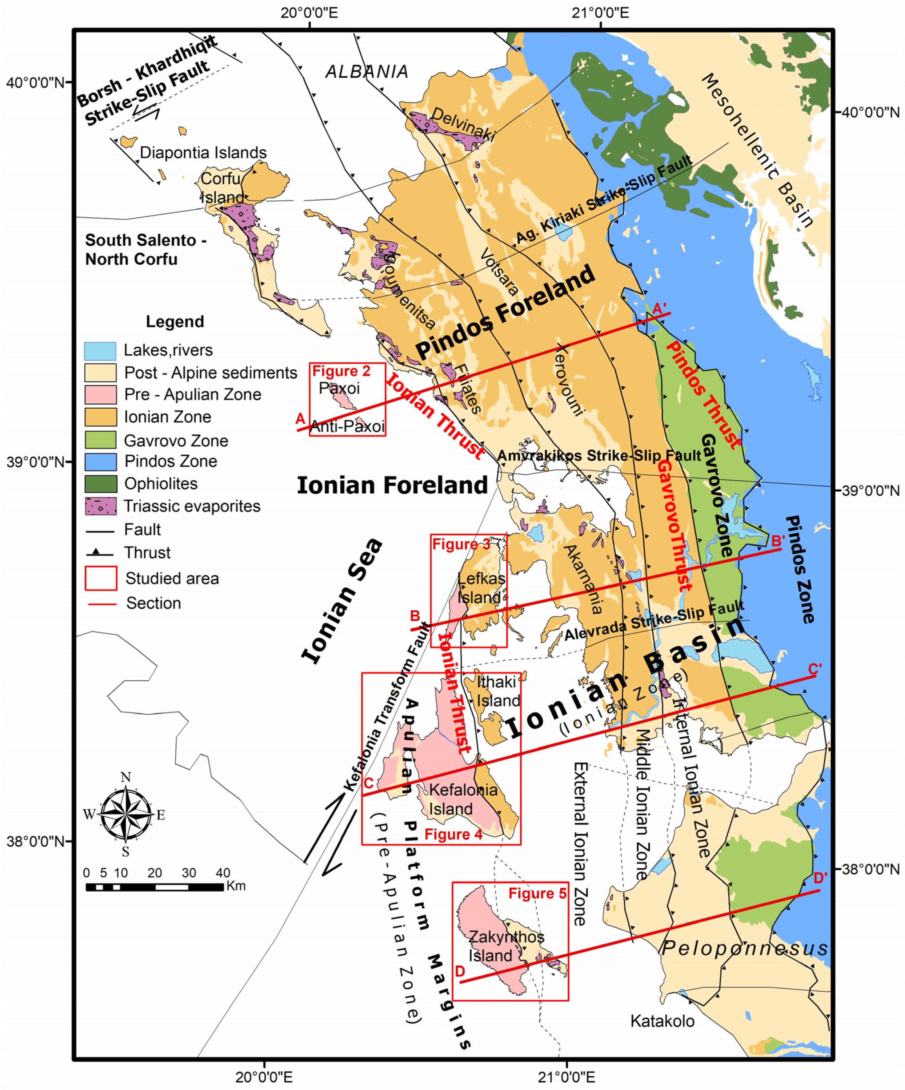
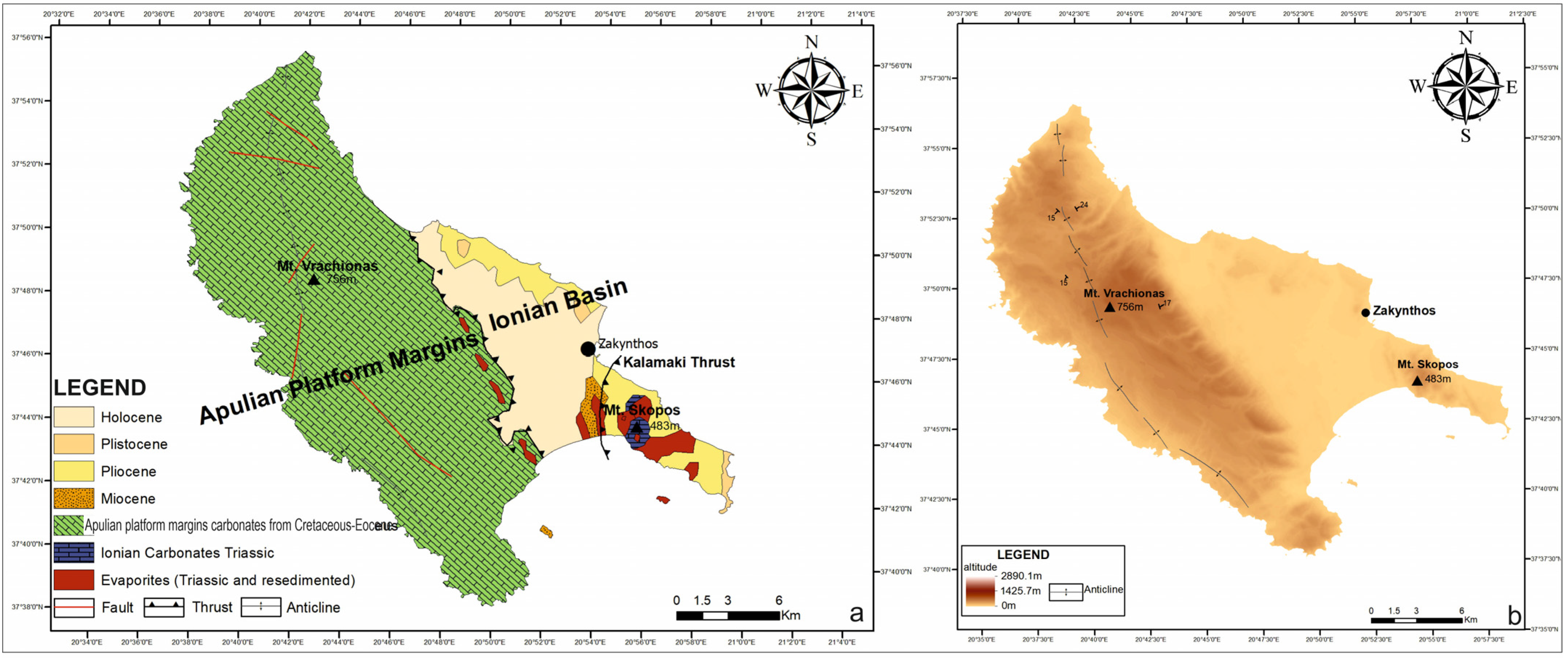
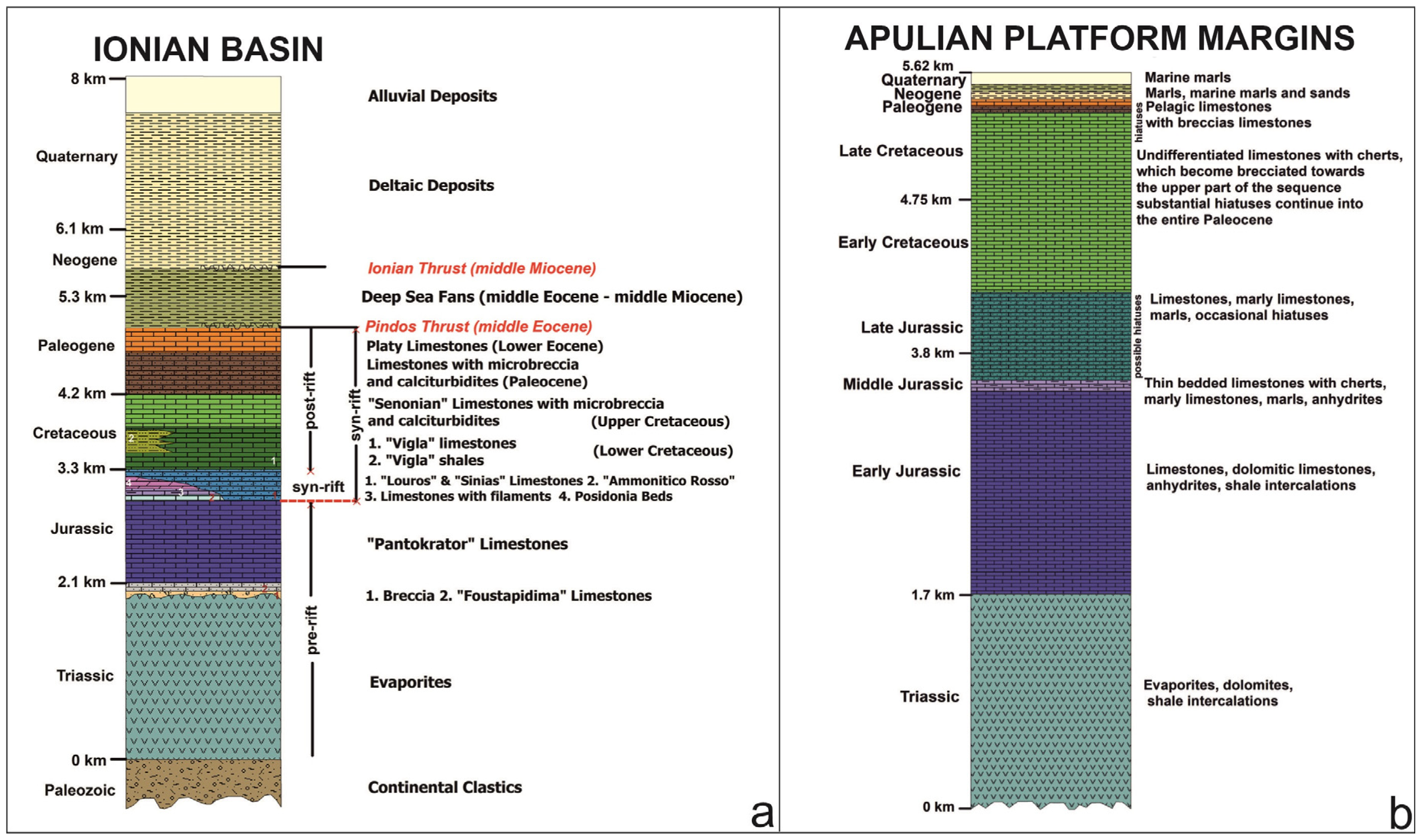
2. Geological Setting

The studied areas of Lefkas, Kefalonia, and Zakynthos Islands are suitable areas for the study of regional structural evolution as both the Ionian Thrust fault (IT) and the Kefalonia transform fault (KTF) have been outcropped. This remote area has been the target of previous expeditions resulting in diverging structural interpretations.
The Hellenic Fold and Thrust Belt were influenced from the Middle Eocene to the Middle Miocene by the External Hellenides (Figure 1). FTB evolution, from east, during the Middle Eocene, to west, during the Middle Miocene, moved to the African and Eurasian plates collision and continuous convergence since the Mesozoic [16].
The Apulian continental block was situated on the southern passive margins of the Tethys Ocean and part of this block was western Greece, during Triassic to Late Cretaceous. During the early Jurassic (Pliensbachian), extension processes were responsible for the Tethys Ocean opening and therefore resulted in the Ionian Basin’s opening [28]. The presence of Triassic evaporites in the thrust between the Apulian Platform margins and the Ionian Basin highlighted that the most important structural control is contractional deformation. Additionally, Triassic evaporites represent the lowest detachment level and are responsible for the development of individual thrust sheets using evaporites as the major decollement surfaces [29].
Ionian Thrust, a crustal scale thrust fault that pushes the Ionian Basin deposits over the Apulian Platform margins, is the major tectonic element throughout Western Greece and the Ionian Islands and has been active since the Middle Miocene. The NW margin of the Hellenic FTB represents a geotectonically complex area of collision, subduction, and transform faulting activity [30]. This corresponds to a compressional zone, placed upon the boundary between the Adriatic and Aegean microplates and the Eurasian-African plates, which in turn corresponds to a general NNW-SSE convergence between Eurasian-African plates.
Moreover, the activity of different branches of the main Ionian Thrust led to the evolution of smaller, confined sub-basins [31]. The Apulian Platform margins represent the continuation of the Apulian Platform to the Ionian Basin, through some edge-slope facies. It is exposed in several Ionian Islands, mainly in the southwestern margins of the Hellenic FTB (e.g., Kefalonia, Zakynthos) and south of Corfu (Paxoi Islands). The absence of Apulian Platform margins in the NW part (Corfu Island) indicates that the Ionian Basin deposits are directly over-thrusting the South Apulia Platform [32] (Figure 1).
As strike-slip faults influenced the regional tectonic evolution the presence of smaller-scale strike-slip faults has dissected the Ionian Thrust [33] (Figure 1). Furthermore, and to the south, the Kefalonia transform fault bisects Western Greece due to an ocean-continent subduction and a continent-continent collision regime. Additionally, the Borsh–Khardhiqit strike-slip to the north of Corfu controls the evolution of the broad region.
In the southern part of Corfu Island, the observed uplift indicates the still Ionian Thrust activity of that southern part. Additionally, and as in the hanging wall of the southern section of the thrust, the Triassic evaporites are covered by Middle to Upper Miocene deposits, and the tectonic activity towards the Miocene–Pliocene boundary, is indicated (Figure 1).
The study of seismic data [34] showed that the Mesozoic deposits were influenced by normal faults and that these normal faults reactivated as thrust faults, during Eocene to Miocene, whereas the same faults reactivated again as normal faults, during Plio-Quaternary. In addition, it is recommended that Mesozoic transfer faults were re-activated during the compressional regime as strike-slip faults, whereas there are some normal faults that during reactivation showed a back-thrust character [28,35] (Figure 1).
Deformation due to collision, based on seismic lines across the Ionian Islands, showed the different structures close and far from the Kefalonia transform fault [15,29,30,35]

3. Material and Methods
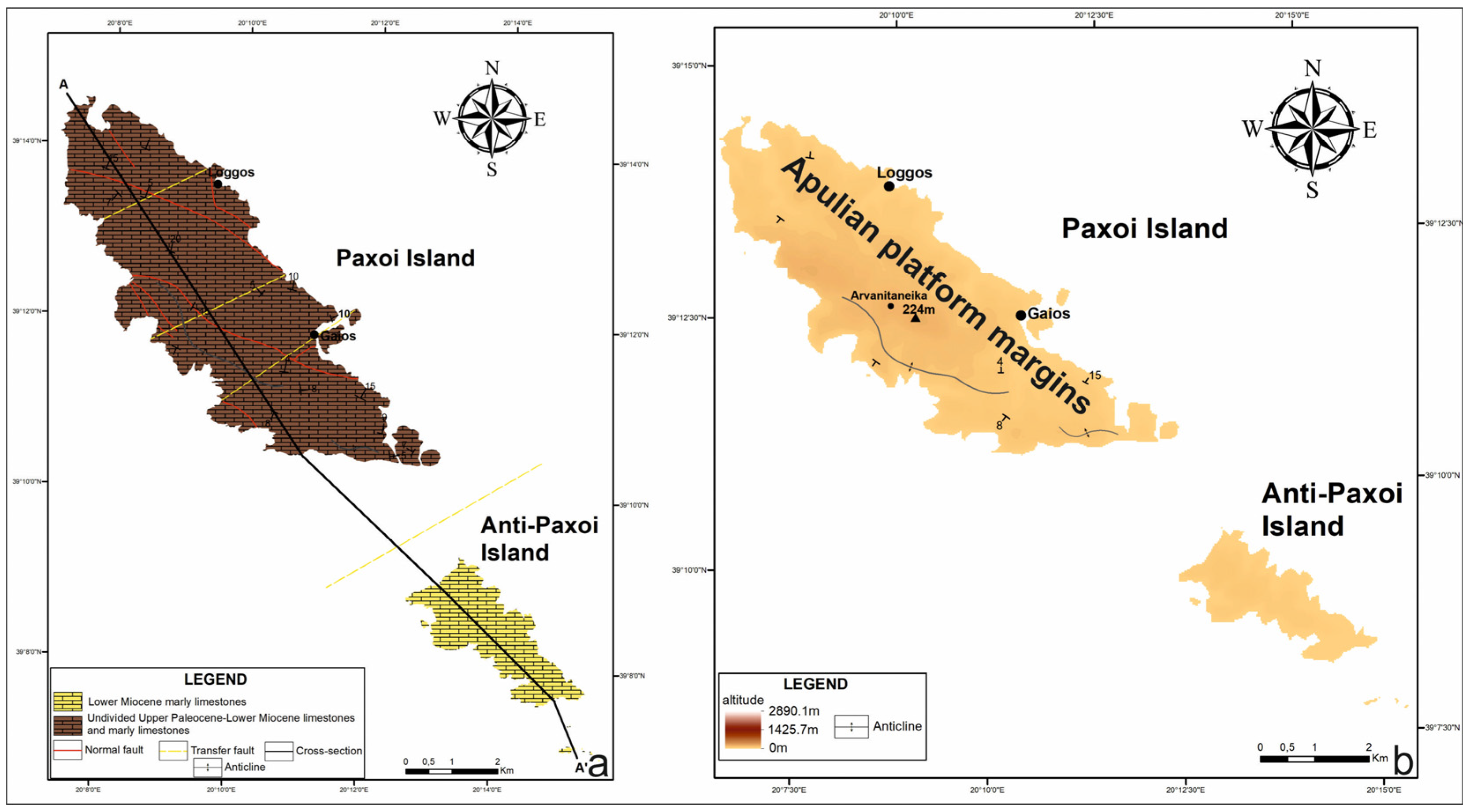
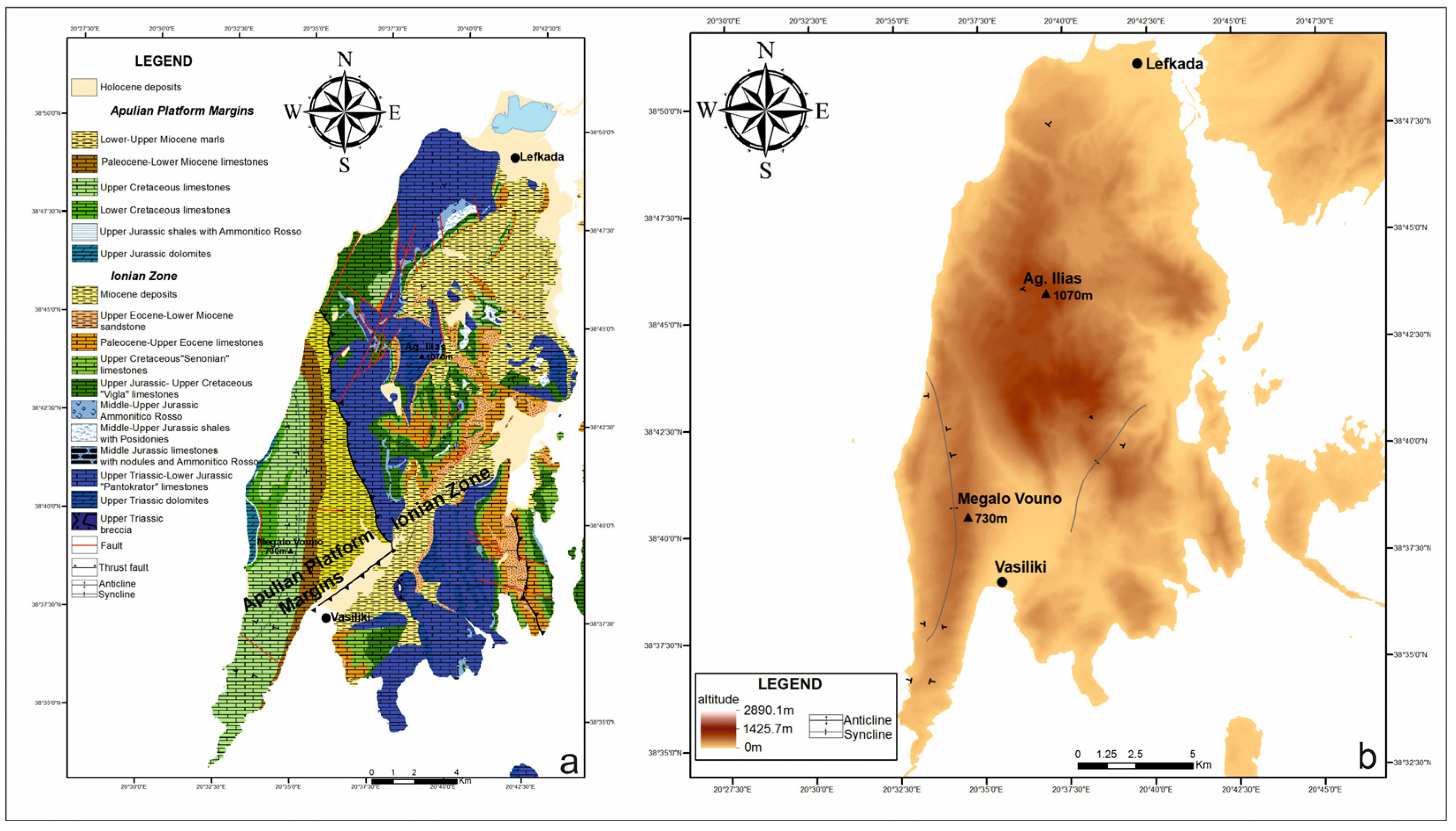
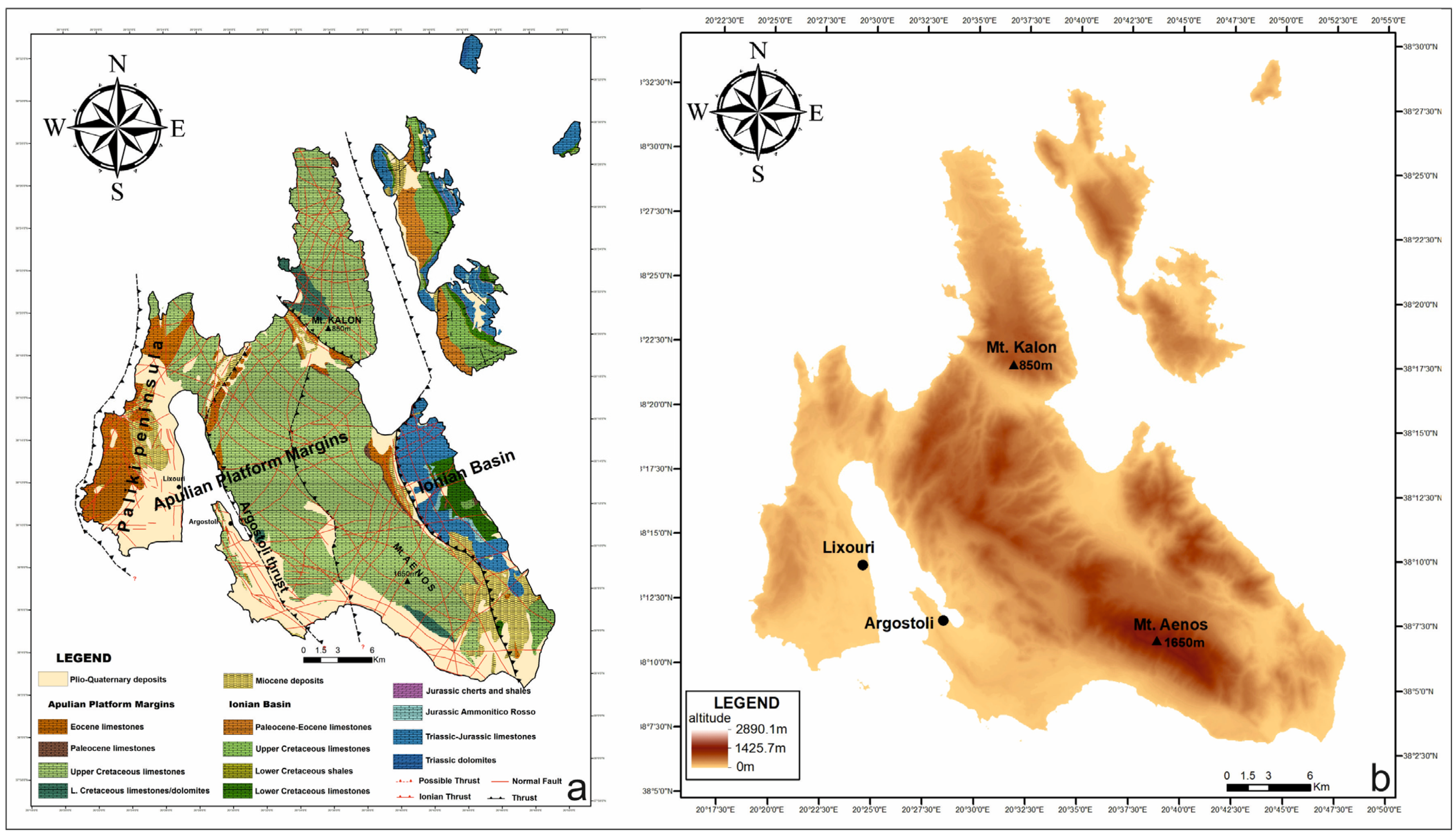
This paper is based on the earlier published papers and measurements during this work. This paper referred to the relief of each Island, the depositional conditions during the extensional regime, the distance of the Ionian Thrust from the Kefalonia transform fault, the activity of Triassic evaporites as décollement surface, the time of inversion from extension to compression and the activity of thrusts and the deformation structures.

4. Results

To understand inversion tectonics, the following techniques were used: The relation with the current relief, with the depositional conditions during the extensional regime, with the distance from the Kefalonia transform fault, with Triassic evaporites, with the age of inversion activity, with the thrusts and deformation structures, and with comparison of all the above in cross-sections.
  • In relation to the current relief
According to the current morphology and the altitudes on the four studied islands, and from north to south, it is shown that the higher altitude in Paxoi and Anti-Paxoi Island is 224 m (Figure 2).
In Lefkas Island, the altitude of the Apulian Platform margins is up to 845 m (western side of the Island), while in the Ionian Basin, as there are at least three internal thrusts, there are high altitudes in different locations ranging from 960 m to 1072 m (Figure 3).
In Kefalonia Island, the highest altitude occurs in Aenos Mountain at 1650 m, and in the northern part of the Island, Kalon Mountain is up to 850 m altitude while the Ionian Basin (eastern side of the Island) reaches up to 1050 m (Figure 4).
Finally, in Zakynthos Island, the highest altitude of Vrachionas Mountain reaches 756m, while the deposits of the Ionian Basin are located on Skopos Mountain at 492m (Figure 5).
  • In relation to the depositional conditions during the extensional regime
According to our results in previous published papers from all islands and considering Accordi et al.’s [36] results, in general, the Ionian deposits were characterized as pelagic and accumulated in deep marine conditions, whereas the Apulian Platform margins deposits showed facies zones that correspond to the platform interior as far as slope to toe of slope or deep shelf environments (Figure 6). The above differences could represent a depositional depth difference ranging from 1000 m to 2000 m. This different depositional depth owed to the normal fault activity that acted in the margins of the Apulian Platform towards the Ionian Basin, where more than one synthetic normal fault added space with different altitudes between the two studied regions.
In detail, the facies zone in Paxoi and Anti-Paxoi Islands Paleocene to lower Miocene deposits represent toe-of-slope to outer slope, but the Ionian Basin is far away from the studied Islands, for comparison. Lefkas Island with upper Cretaceous to lower Eocene deposits accumulated in toe-of-slope to outer slope environments. Kefalonia Island showed many differences from north to south and from west to east. In general, the southern part with the upper Cretaceous deposits (Aenos region) and the Paliki peninsula with Paleocene to lower Miocene deposits mostly deposited in the platform interior, whereas the northern region mostly accumulated to the toe-of-slope to outer slope environment. Upper Cretaceous deposits of Zakynthos Island that outcropped in the central and northern parts accumulated in a platform interior whereas the southern part with upper Cretaceous deposits accumulated in toe-of-slope to outer slope environments. Paleocene deposits in the southern end accumulated in the platform interior.
  • In relation to the distance from the Kefalonia transform fault
Paxoi and Anti-Paxoi Islands were not influenced by the KTF. The distance of Ionian Thrust in Lefkas Island from KTF ranges from 0 to 15 km, in Kefalonia Island the distance ranges from 12 to 50 km, whereas the distance of Ionian Thrust from KTF in Zakynthos Island ranges from 50 to 80 km.
  • In relation to Triassic evaporites
Previously published papers showed that the decollement surface was the evaporitic deposits and these outcropped in western Greece, in contact with the thrusts, internally to the Ionian basin. Triassic evaporites outcropped only in Zakynthos Island from the studied Islands in contact with the Ionian Thrust but also outcropped along to the Ionian Thrust in Corfu Island.
  • In relation to the age of inversion activity
The change of the tectonic regime from extension to compression took place during the Middle Miocene [16,37].
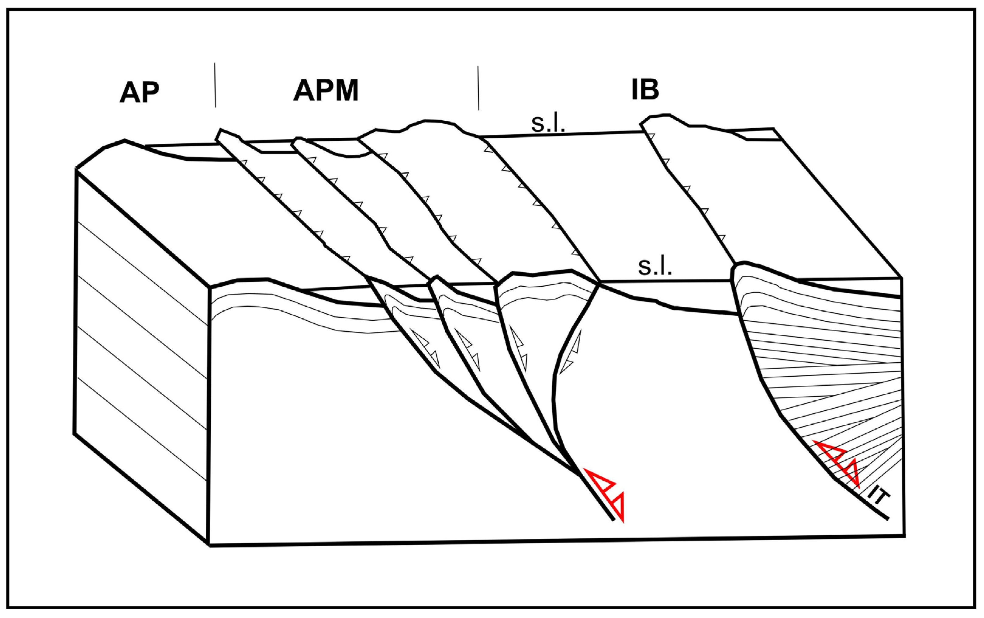
  • In relation to the thrusts and deformation structures
In the Paxoi and Anti-Paxoi Islands, where there is no influence of KTF, there are no recognized thrust faults. According to the synsedimentary deformation structures [37] that developed during the Paleocene to Early Miocene, it seems that the basin floor was influenced by the normal faults’ activity internally to the Apulian Platform Margins during the rifting stage. These normal faults probably reactivated as thrust faults during the Middle Miocene inversion and the Islands came up, uplifted, and now are in the air.
In Lefkas Island, the Ionian Thrust is very close to the KTF, and due to this proximity, there is no additional thrust in the Apulian Platform Margins. In the Ionian Basin deposits, at least three internal branches of the Ionian Thrust were recognized, which strongly deformed the Ionia Basin deposits, with the development of accompanied small and restricted piggyback basins internally to the Ionian Basin.
In Kefalonia Island, with a mid-distance from the KTF, in relation to the distance from Lefkas and Zakynthos Islands, at least three internal branches of the Ionian Thrust were active in producing small and restricted foreland basins, where submarine fans accumulated [31].
Additionally, it has been mentioned that in the Lefkas and Kefalonia Islands, the contact between the deposits of the Ionia Basin and the Apulian Platform Margins, due to the Ionian Thrust activity ranges from 300 m to 3 km.
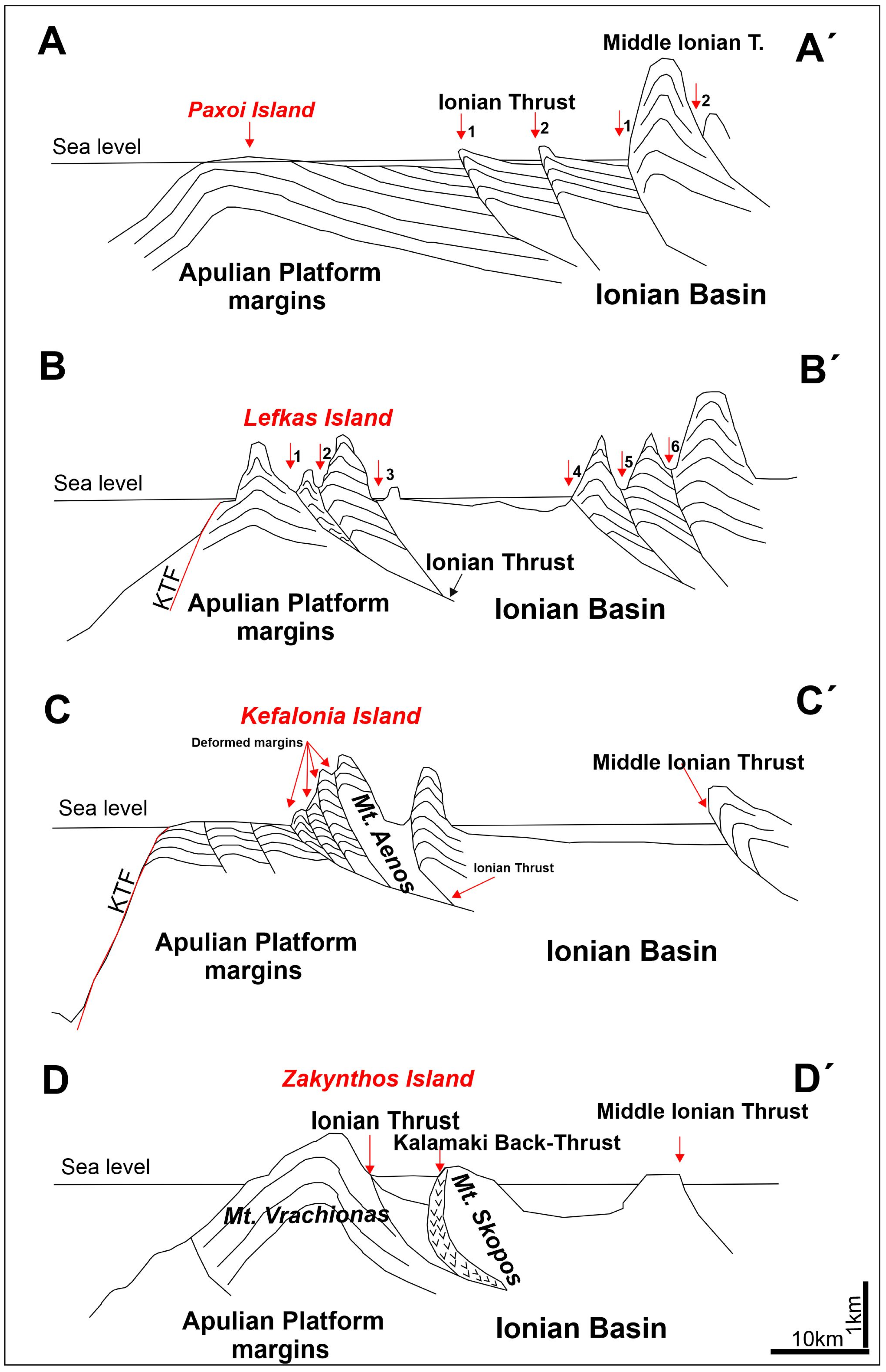
  • Comparing all the above in four cross-sections
In order to build up our theory using the tools mentioned and analyzed previously, four cross-sections were created showing the development of the four Islands. In detail:
The A-A’ and D-D’ sections (Figure 7) suggest that when the area influenced by the Ionian Thrust (IT) is situated remotely from the Kefalonia transform fault (KTF) then the deformation is the same. As the IT affected the margins of the Apulian Platform, a high angle anticline was formed in both cases (Paxoi Anticline–PA), with up to 200 m altitude, and Vrachionas Anticline (VA), with up to 550 m altitude, in Zakynthos Island). In Paxoi (Figure 7A-A’, Figure 8), the KTF is not present and therefore sufficient space is available, a conventional foreland basin was formed, below sea level. In Zakynthos Island (Figure 7D-D’), the Ionian fault pushes the margins of the Apulian Platform towards the KTF. In this case, the space was limited, resulting in margin uplift and producing the VA. The Ionian Thrust gradually evolved into the Kalamaki Back Thrust (KBT).
In addition, when the deformation is at close proximity to the KTF (Figure 7 cross sections B-B’ and C-C’) then the results differ.
In the case where IT is very close to the KTF (Figure 7B-B’) and limited preserved space exists, only the pre-existing deposits of the Ionian Basin were deformed, producing numerous synclines and anticlines, with highest altitudes up to 1150 m. Additionally, the margins of the Apulian Platform, restricted or protected from the KTF, were deformed generating altitudes up to 750 m, between KTF and IT.
In Kefalonia Island (Figure 7C-C’), the Apulian Platform margins present the most interesting structures, because they were deformed from the compression of the IT producing several small foreland basins. The Paliki Peninsula (PP) (up to 450 m altitude) is in close proximity to the KTF and exhibits slumped blocks in opposite directions (eastward directed) over younger deposits. This is most likely because of limited space available Aenos Mountain (AM) with up to 1650 m altitude (the highest in the Ionian Islands) was formed because of the westward movement of the IT. Although space from AM to PP peninsula is available, the strong uplifted block of AM could be related to the high angle of the pre-existing normal fault and its great displacement, as well as the coexistence of another thrust fault in Argostoli Gulf (AG). This suggests that AM could represent the wedge top of the Argostoli thrust.

5. Discussion

The boundary margins between the stable Apulian Platform and the Ionian Basin display changes in the tectonic regime from extensional to compressional regime, with characteristic structures [2,3,34] (Figure 9). During the Eocene to Middle Miocene, the pre-existing normal faults reactivated as thrust faults from east to west and the transfer faults as strike-slip faults producing different structures. The type of tectonic structures generated by the inversion tectonics depends on both the existing displacement of the marginal normal faults, the pre-existing depositional environments, and the proximity of the IT to the KTF.
Parameters such as the pre-existing displacement of normal faults, the frequency of normal faults, and the proximity to transfer faults that could be reactivated as strike-slip faults are important in the study of inversion tectonic structures.
The fact that Mt Aenos with the highest altitude formed between the Ionian Thrust and the internal thrust of the Apulian Platform Margins, that of >2500 m, as a reaction to the compression of a deep marine environment towards a platform interior, means that there was a large difference in depositional depth could explain why Aenos was not over-thrusted but only uplifted.
The fact that the deposits of the Ionian Basin of Lefkas are stratigraphically composed of Triassic evaporites explains why the Ionian deposits were broken into blocks using the evaporites as decollement surfaces when they crashed into the Apulian Platform Margins with a large difference in altitude between the Ionian Basin and Apulian Platform Margin deposits.
The fact that both Paxoi and Zakynthos Islands deposits showed only open anticline geometry could be explained by the events being either without any influence from the KTF or far away from the KTF and independent of the difference in depositional depth between Apulian Platform margins and Ionian Basin.

6. Conclusions

Apulian Platform margins represent the transition margins from the Apulian Platform to the Ionian Basin and were formed because of the extensional tectonic activity, associated with normal faults during the Mesozoic. The differences in the displacement of the marginal faults and so on in the depositional depth between the two different areas and the influenced area from north to south generated areas that differ in size and bathymetry. During the Eocene to the Middle Miocene, the normal faults reactivated as thrust faults, and the produced deformation was influenced by the existing displacement and the presence of KTF. The compressional regime started its activity during the Middle Eocene in the eastern areas and slowly migrated westwards where during the Middle Miocene the Ionian Thrust activated producing different footprints on current relief.
In cases of limited space between KTF and Ionian Thrust, both Apulian Platform margins and the Ionian Basin deposits were deformed. In cases of space availability, as in Kefalonia Island, the reactivation of marginal normal faults generated small foreland basins within the region of the Apulian Platform Margins. In the case of limited space, the piggyback basin was formed within the Ionian Basin region many times due to back-thrusts. In the case of no influence or being far away from the KTF, the Ionian Thrust deformed the Apulian Platform Margins producing open anticlines.

Author Contributions

Conceptualization, A.Z. and N.B.; methodology, N.B.; software, N.B.; validation, A.Z.; formal analysis, A.Z. and N.B.; investigation, A.Z., N.B., E.Z. and A.G.M.; data curation, A.Z.; writing—original draft preparation, A.Z., N.B., E.Z. and A.G.M.; writing—review and editing, A.Z., N.B., E.Z. and A.G.M.; visualization, A.Z.; supervision, A.Z.; project administration, A.Z. All authors have read and agreed to the published version of the manuscript.

Funding

This research received no external funding.

Data Availability Statement

The data created will be available upon request from the corresponding author.

Conflicts of Interest

The authors declare no conflict of interest.

References

  1. Ziegler, P.A. Evolution of the Arctic-North Atlantic and the Western Tethys. AAPG Mem. 1988, 43, 198. [Google Scholar]
  2. Basilone, L. Seismogenic rotational slumps and translational glides in pelagic deep-water carbonates. Upper Tithonian-Berriasian of Southern Tethyan margin (W Sicily, Italy). Sediment. Geol. 2017, 356, 1–14. [Google Scholar] [CrossRef]
  3. Basilone, L.; Sulli, A. Basin analysis in the Southern Tethyan margin: Facies sequences, stratal pattern and subsidence history highlight extension to inversion processes in the Cretaceous Panormide carbonate platform (NW Sicily). Sediment. Geol. 2018, 363, 235–251. [Google Scholar] [CrossRef]
  4. Cooper, M.A.; Warren, M.J. Inverted fault systems and inversion tectonic settings. In Regional Geology and Tectonics, Principles of Geologic Analysis, 2nd ed.; Scarselli, N., Adam, J., Chiarella, D., Roberts, D.G., Bally, A.W., Eds.; Elsevier: Amsterdam, The Netherlands, 2020; Volume 1, pp. 169–204. [Google Scholar]
  5. Brekke, H.; Riis, F. Tectonics and basin evolution of the Norwegian shelf between 62°N and 72°N. Nor. Geol. Tidsskr. 1987, 67, 295–322. [Google Scholar]
  6. Doré, A.G.; Lundin, E.R.; Jensen, L.N.; Birkeland, Ø.; Eliassen, P.E.; Fichler, C. Principal tectonic events in the evolution of the northwest European Atlantic margin. In Petroleum Geology of Northwest Europe: Proceedings of the 5th Conference; The Geological Society of London: London, UK, 1997; pp. 41–61. [Google Scholar]
  7. Price, S.; Brodie, J.; Whitham, A.; Kent, R.A.Y. Mid-Tertiary rifting and magmatism in the Traill Ø region, East Greenland. J. Geol. Soc. 1997, 154, 419–434. [Google Scholar] [CrossRef]
  8. Dore, A.G.; Lundin, E.R. Cenozoic compressional structures on the NE Atlantic margin; nature, origin and potential significance for hydrocarbon exploration. Pet. Geosci. 1996, 2, 299–311. [Google Scholar] [CrossRef]
  9. Arthaud, F.; Choukroune, P.; Robineaue, B. Evolution structurale de la zone transformante d’Arta (République de Djibouti). Bull. Soc. Geol. Fr. 1980, 22, 909–915. [Google Scholar] [CrossRef]
  10. Gaulier, J.M.; Huchon, P. Tectonic evolution of Afar triple junction. Bull. Soc. Geol. 1991, 162, 451–464. [Google Scholar] [CrossRef]
  11. Ring, U. The influence of preexisting structure on the evolution of the Cenozoic Malawi rift (East African rift system). Tectonics 1994, 13, 313–326. [Google Scholar] [CrossRef]
  12. Morley, C.K.; Cunningham, S.M.; Harper, R.M.; Wescott, W.A. Geology and geophysics of the Rukwa Rift, East Africa. Tectonics 1992, 11, 69–81. [Google Scholar] [CrossRef]
  13. Morley, C.K.; Wescott, W.A.; Harper, R.M.; Wigger, S.T.; Day, R.A.; Karanja, F.M. Geology and Geophysics of the Western Turkana Basins, Kenya. In Geoscience of Rift Systems—Evolution of East Africa, 2nd ed.; Morley, C.K., Ed.; AAPG Studies in Geology: Tulsa, OK, USA, 1999; Volume 44, pp. 19–54. [Google Scholar]
  14. Ring, U.; Betzler, C.; Delvaux, D. Normal vs. strike-slip faulting during rift development in East Africa: The Malawi rift. Geology 1992, 20, 1015–1018. [Google Scholar] [CrossRef]
  15. Sakkas, V.; Kapetanidis, V.; Kaviris, G.; Spingos, I.; Mavroulid, S.; Diakakis, M.; Alexopoulos, J.D.; Kazantzidou-Firtinidou, D.; Kassaras, I.; Didalos, S.; et al. Seismological and Ground Deformation Study of the Ionian Islands (W. Greece) during 2014–2018, a period of Intense Seismic Activity. Appl. Sci. 2022, 12, 2331. [Google Scholar] [CrossRef]
  16. Zelilidis, A.; Piper, D.J.W.; Vakalas, J.; Avramidis, P.; Getsos, K. Oil and gas plays in Albania: Do equivalent plays exist in Greece? J. Pet. Geol. 2003, 26, 29–48. [Google Scholar] [CrossRef]
  17. Karakitsios, V.; Rigakis, N. Evolution and Petroleum Potential of Western Greece. J. Pet. Geol. 2007, 30, 197–218. [Google Scholar] [CrossRef]
  18. Bernoulli, D.; Renz, O. Jurassic carbonate facies and new ammonite faunas from western Greece: Eclog. Eclogae Geol. Helv. 1970, 63, 573–607. [Google Scholar]
  19. Karakitsios, V. Ouverture et Inversion Tectonique du Basin Ionien (Epire, Grèce). Ann. Géol. Pays Héllen 1992, 35, 185–318. [Google Scholar]
  20. van Hinsbergen, D.J.J.; van der Meer, D.G.; Zachariasse, W.J.; Meulenkamp, J.E. Deformation of western Greece during Neogene clockwise rotation and collision with Apulia. Int. J. Earth Sci. 2005, 95, 463–490. [Google Scholar] [CrossRef]
  21. Tankard, A.J.; Balkwill, H.R. Extensional Tectonics and Stratigraphy of the North Atlantic Margins; American Association of Petroleum Geologists: Tulsa, OK, USA, 1989; Volume Memoir 46, 641p. [Google Scholar]
  22. Jackson, M.P.A.; Vendeville, B.C. Regional extension as a geologic trigger for diapirism. Geol. Soc. Am. Bull. 1994, 106, 57–73. [Google Scholar] [CrossRef]
  23. Vendeville, B.C.; Nilsen, K.T. Episodic growth of salt diapirs driven by horizontal shortening. In Salt, Sediment, and Hydrocarbons: Society of Economic Paleontologists and Mineralogists Gulf Coast Section, 16th Annual Research Conference Program and Extended Abstracts, Los Angeles, CA, USA, December 1995; SEPM Society for Sedimentary Geology: Claremore, OK, USA, 1995; pp. 285–295. [Google Scholar]
  24. Vendeville, B.C.; Jackson, M.P.A. The fall of diapirs during thin-skinned extension. Mar. Pet. Geol. 1992, 9, 354–371. [Google Scholar] [CrossRef]
  25. Hudec, M.R.; Jackson, M.P.A. Terra infirma: Understanding salt tectonics. Earth-Sci. Rev. 2007, 82, 1–28. [Google Scholar] [CrossRef]
  26. Jackson, M.P.A.; Hudec, M.R. Salt Tectonics. In Principles and Practice; Cambridge University Press: Cambridge, UK, 2017; ISBN 978-1-107-01331-5. [Google Scholar]
  27. Zelilidis, A.; Papatheodorou, G.; Maravelis, A.; Christodoulou, D.; Tserolas, P.; Fakiris, E.; Dimas, X.; Georgiou, N.; Ferentinos, G. Interplay of thrust, back-thrust, strike-slip and salt tectonics in a Fold and Thrust Belt system: An example from Zakynthos Island, Greece. Int. J. Earth Sci. 2016, 105, 2111–2132. [Google Scholar] [CrossRef]
  28. Bourli, N.; Pantopoulos, G.; Maravelis, A.G.; Zoumpoulis, E.; Iliopoulos, G.; Pomoni-Papaioannou, F.; Kostopoulou, S.; Zelilidis, A. Late Cretaceous to early Eocene geological history of the eastern Ionian Basin, southwestern Greece: A sedimentological approach. Cretac. J. 2019, 98, 47–71. [Google Scholar] [CrossRef]
  29. Zelilidis, A.; Maravelis, A.G.; Tserolas, P.; Konstantopoulos, P.A. An overview of the Petroleum systems in the Ionian zone, onshore NW Greece and Albania. J. Pet. Geol. 2015, 38, 331–348. [Google Scholar] [CrossRef]
  30. Maravelis, A.; Makrodimitras, G.; Zelilidis, A. Hydrocarbon prospectivity in the Apulian platform and Ionian zone, in relation to strike-slip fault zones, foreland and back-thrust basins of Ionian thrust, in Greece. Oil Gas Eur. Mag. 2012, 38, 64–89. [Google Scholar]
  31. Tserolas, P.; Maravelis, A.; Pasadakis, N.; Zelilidis, A. Organic geochemical features of the Upper Miocene successions of Lefkas and Cephalonia islands, Ionian Sea, Greece: An integrated geochemical and statistical approach. Arab. J. Geosci. 2018, 11, 105. [Google Scholar] [CrossRef]
  32. Del Ben, A.; Mocnika, A.; Volpib, V.; Karvelis, P. Old domains in the South Adria plate and their relationship with the West Hell. front. J. Geodyn. 2015, 89, 15–28. [Google Scholar] [CrossRef]
  33. Avramidis, P.; Zelilidis, A. The nature of deep-marine sedimentation and palaeocurrent trends as an evidence of Pindos foreland basin fill conditions. Episodes 2001, 24, 252–256. [Google Scholar] [CrossRef] [PubMed]
  34. Kokinou, Ε.; Kamberis, Ε.; Vafidis, A.; Monopolis, D.; Ananiadis, G.; Zelilidis, A. Deep seismic reflection data from off-shore western Greece: A new crustal model for the Ionian Sea. J. Pet. Geol. 2005, 28, 81–98. [Google Scholar] [CrossRef]
  35. Karakitsios, V. Western Greece and Ionian Sea petroleum systems. AAPG 2013, 97, 1567–1594. [Google Scholar] [CrossRef]
  36. Accordi, G.; Carbone, F.; Di Carlo, M.; Pignatti, J. Microfacies analysis of deep-water breccia clasts: Shallow vs. deep-ramp Paleogene sedimentation in Cephalonia and Zakynhtos (Ionian Islands, Greece). Facies 2014, 60, 445–466. [Google Scholar] [CrossRef]
  37. Bourli, N.; Iliopoulos, G.; Zelilidis, A. Reassessing Depositional Conditions of the Pre-Apulian Zone Based on Synsedimentary Deformation Structures during Upper Paleocene to Lower Miocene Carbonate Sedimentation, from Paxoi and Anti-Paxoi Islands, Northwestern End of Greece. Minerals 2022, 12, 201. [Google Scholar] [CrossRef]
Figure 1. Geological map of the studied area with the four studied cross-sections [28].
Geosciences 14 00203 g001
Figure 2. (a) Geological map and (b) geomorphological map of Paxoi and Anti-Paxoi Island.
Geosciences 14 00203 g002
Figure 3. (a) Geological map and (b) geomorphological map of Lefkas Island.
Geosciences 14 00203 g003
Figure 4. (a) Geological map and (b) geomorphological map of Kefalonia Island.
Geosciences 14 00203 g004
Figure 5. (a) Geological map and (b) geomorphological map of Zakynthos Island.
Geosciences 14 00203 g005
Figure 6. Lithostratigraphic columns of (a) Ionian Basin and (b) Apulian Platform margins.
Geosciences 14 00203 g006
Figure 7. Four cross-sections depict the major structures based on Google Earth Relief. For the abbreviations see the text and for the locations see Figure 1.
Geosciences 14 00203 g007
Figure 8. Εvolutionary stages of development from rifting stage to present, applied to Paxoi and Anti-Paxoi Islands. (a) The rifting stage; (b) the change of the extensional to compressional regime with the reactivation of normal faults as reverse faults (inverted tectonic) and the gradual change from the Apulian platform margins to the forebulge area of the Ionian foreland and (c) the present morphology of Paxoi and Anti-Paxoi Islands with an open anticline geometry due to the Ionian thrust movement [37].
Geosciences 14 00203 g008
Figure 9. The block diagram illustrates how the tectonic inversion influenced the Apulian Platform Margins (APM) producing small, restricted foreland basins.
Geosciences 14 00203 g009
Disclaimer/Publisher’s Note: The statements, opinions and data contained in all publications are solely those of the individual author(s) and contributor(s) and not of MDPI and/or the editor(s). MDPI and/or the editor(s) disclaim responsibility for any injury to people or property resulting from any ideas, methods, instructions or products referred to in the content.

