Article

Coupling Driving Force–Pressure–State–Impact–Response–Management Framework with Hydrochemical Data for Groundwater Management on Sithonia Peninsula, Greece †

by
Eleni Parastatidou
1,
Maria Margarita Ntona
2,
Nerantzis Kazakis
3,* and
Fotios-Konstantinos Pliakas
1
1
Laboratory of Engineering Geology and Groundwater Research, Department of Civil Engineering, Democritus University of Thrace, 67100 Xanthi, Greece
2
Laboratory of Engineering Geology & Hydrogeology, Department of Geology, Aristotle University of Thessaloniki, 54124 Thessaloniki, Greece
3
Laboratory of Hydrogeology, Department of Geology, Faculty of Natural Sciences, University of Patras, Rion, 26504 Patras, Greece
*
Author to whom correspondence should be addressed.
This paper is an extended version of that published in the Proceedings of the 12th International Hydrogeological Conference of Greece and Cyprus. Parastatidou E., Kazakis N., Pliakas F.K. (2022). Water resources and DPSIR framework. The case of Sithonia, Chalkidiki Prefecture, North Greece. 12th International Hydrogeological Conference of Greece and Cyprus, Cyprus, 20–22 March 2022; pp. 374–377.
Geosciences 2025, 15(1), 24; https://doi.org/10.3390/geosciences15010024
Submission received: 24 November 2024 / Revised: 9 January 2025 / Accepted: 10 January 2025 / Published: 11 January 2025
(This article belongs to the Section Hydrogeology)

Abstract

:
Water scarcity in coastal tourist areas constitutes a critical environmental and socioeconomic sustainability issue. Hence, it is crucial to implement an integrated water resource management and protection plan. In this research, the DPSIR framework is coupled with hydrochemical data on groundwater resources in the fractured aquifer of the Sithonia Peninsula in Chalkidiki, North Greece. Geographical and demographic data, together with morphology, geology, hydrology, and groundwater quality data, were collected and evaluated to categorize the hydrosystem’s driving forces, pressures, states, impacts, and responses. The main pressures that affect groundwater quality in the study area are tourism, geological formation, and land use. Based on the analysis of the DPSIR framework, the absence of a landfill site, the inadequate operation of sewage treatment plants and biological wastewater treatment systems, and tourist activity contribute significantly to the degradation of groundwater quality. Additionally, the fractured rock aquifer develops preferential flow paths to pollutants through preexisting faults, which influence groundwater quality. The hydrochemical analysis of groundwater indicates seawater intrusion in the coastal area. The combination of DPSIR analysis and a water quality index based on ion ratios of groundwater samples identifies high-risk areas of seawater intrusion. Thus, it is essential to reinforce groundwater resources by implementing managed aquifer recharge, limiting unnecessary use of groundwater during the tourist season, and storing surface water during the wet period.

1. Introduction

Water scarcity in coastal tourist areas is a significant environmental and socioeconomic challenge threatening global sustainable development [1]. Managing water resources in these regions requires integrated approaches that incorporate environmental and human factors [2]. Coastal regions, particularly in the Mediterranean, are increasingly vulnerable to a combination of pressures, including groundwater overexploitation, contamination by human activities, and the intensifying impacts of climate variability [3].
Due to its favorable climate conditions, the main economic sectors in the Mediterranean region are agricultural activities and tourism. The Sithonia Peninsula (N Greece) is a prime example of a region facing a combination of the above-mentioned pressures, where intense seasonal tourism and agricultural activity affect groundwater quality and quantity and seawater intrusion is a major concern.
In recent decades, Greece has received funding from both national and European management services for rural development programs [4]. Rural development programs by the General Secretariat of Union Resources and Infrastructure in Greece focus on developing economically and environmentally oriented policies to improve the quality of life in rural areas and ensure the environmentally sustainable management of natural resources. Nevertheless, the climate crisis has a negative impact on the sustainable management of water systems, complicating the situation [5]. Greece is facing challenges in improving the competitiveness of the agriculture, forestry, and agro-food sectors under climate crisis conditions [6,7]. Sea water level rise, drought events, and extreme rainfall events are some of the pressures that affect the quality and quantity of groundwater systems. Groundwater depletion constitutes a severe threat to the water supply of coastal zones [8]. Thus, sustainable water management plans need to be implemented based on the specific needs of each region to protect both the natural environment and water resources. Understanding and categorizing the factors that impact environmental sustainability are crucial for establishing protective regulations [9]. To succeed in this research step, the application of a framework for categorizing the driving forces that describe the interconnections between human activities and the environment was proposed.
The DPSIR framework (driving forces—D; pressures—P; states—S; impacts—I; responses—R) was developed in the late 1990s by the Organization of Economic Co-operation and Development (OECD) as a method of constructing and organizing indicators [10]. It was later adopted as a conceptual model by the European Environmental Agency in 1995 and has since been applied widely in numerous research studies to develop and explain the relationship between environmental and human systems [11,12,13]. Today, this framework is applied globally and serves as an analytical tool for studying surface and groundwater systems [14,15]. The DPSIR method is a crucial tool used to identify and describe processes and interactions between human and environmental systems [16,17], encompassing economic, environmental, and social factors [18]. It is frequently used to develop indicators for assessing water security [19]. This framework is based on the Pressure–State–Response (PSR) model developed in the 1970s by Canadian statistician Anthony Fried [12,20] and was later refined by the OECD in 2003 [10]. The PSR model focuses on human needs and activities and their impact on natural ecosystems, providing a foundation for simplifying and solving complex problems [21]. The aim was to establish a structure that would enable the identification of indicators, offering information to policymakers regarding the environment’s condition and its relevance to present short-term and long-term political decisions [22,23,24]. Within a short period, the DPSIR framework has been applied by researchers from various scientific fields for environmental research [25,26]. It serves as an analytical tool for studying water issues, allowing for a comprehensive assessment by examining the relevant driving forces and pressures on the environment, the state of the environment and its impacts, the responses undertaken, and the interconnections between these elements [26]. In the DPSIR framework, socioeconomic developments (drivers) exert pressures on a given state of the environment, resulting in impacts on ecosystems, human health, and society, leading to sociopolitical responses [26]. Responses can feed back into drivers, pressures, states, or impacts [27,28,29].
The DPSIR framework is considered an essential tool for society and decision-making stakeholders on issues related to water resource management [30,31]. It is mainly used to study cases related to human activities and management efforts in terrestrial, coastal, and marine ecosystems [32,33,34,35,36,37]. For instance, it has been used to address problems in coastal marine environments, namely coastal areas, lagoons, deltaic systems, estuaries, and river basins. In addition, this framework has been implemented in waste management projects [38] in studies in various Greek river basins, such as Nestos River [39,40], Axios River, and Thermaikos Gulf [41], in a combination of Mediterranean catchments [42], in Qatar [43], and in rivers in the Balkans [40].
Previous studies have applied the DPSIR framework to assess environmental and human impacts on water resources. Nevertheless, combining the DPSIR framework with detailed hydrochemical analysis provides a comprehensive approach to quantifying the impacts of factors through direct chemical data [44].
This study aims to fill a critical gap in the literature by focusing on a highly touristic area with fractured rock aquifers, where limited studies have been conducted on groundwater management under its complex conditions. A combination of DPSIR analysis and hydrochemical data offers a novel approach to determining sustainable measures for groundwater management. The Peninsula of Sithonia in North Greece is an optimal example for DPSIR application, focusing on intense tourism and unbalanced groundwater exploitation. This paper presents an innovative research approach that combines the DPSIR framework and a seawater index, following a hydrochemical analysis of groundwater samples.

2. Study Area

The study area is located on the Sithonia Peninsula of Chalkidiki, North Greece, with lowland and sloping hills of a maximum altitude of 805 m (Figure 1). A significant part of the peninsula is covered by protected areas, with 54.7% of its area belonging to Special Protection Areas (SPAs) and 45.3% belonging to Special Conservation Zones (SCZs). The average annual precipitation and temperature for the period 2015–2020 were recorded as 403.4 mm and 17.7 °C, respectively.
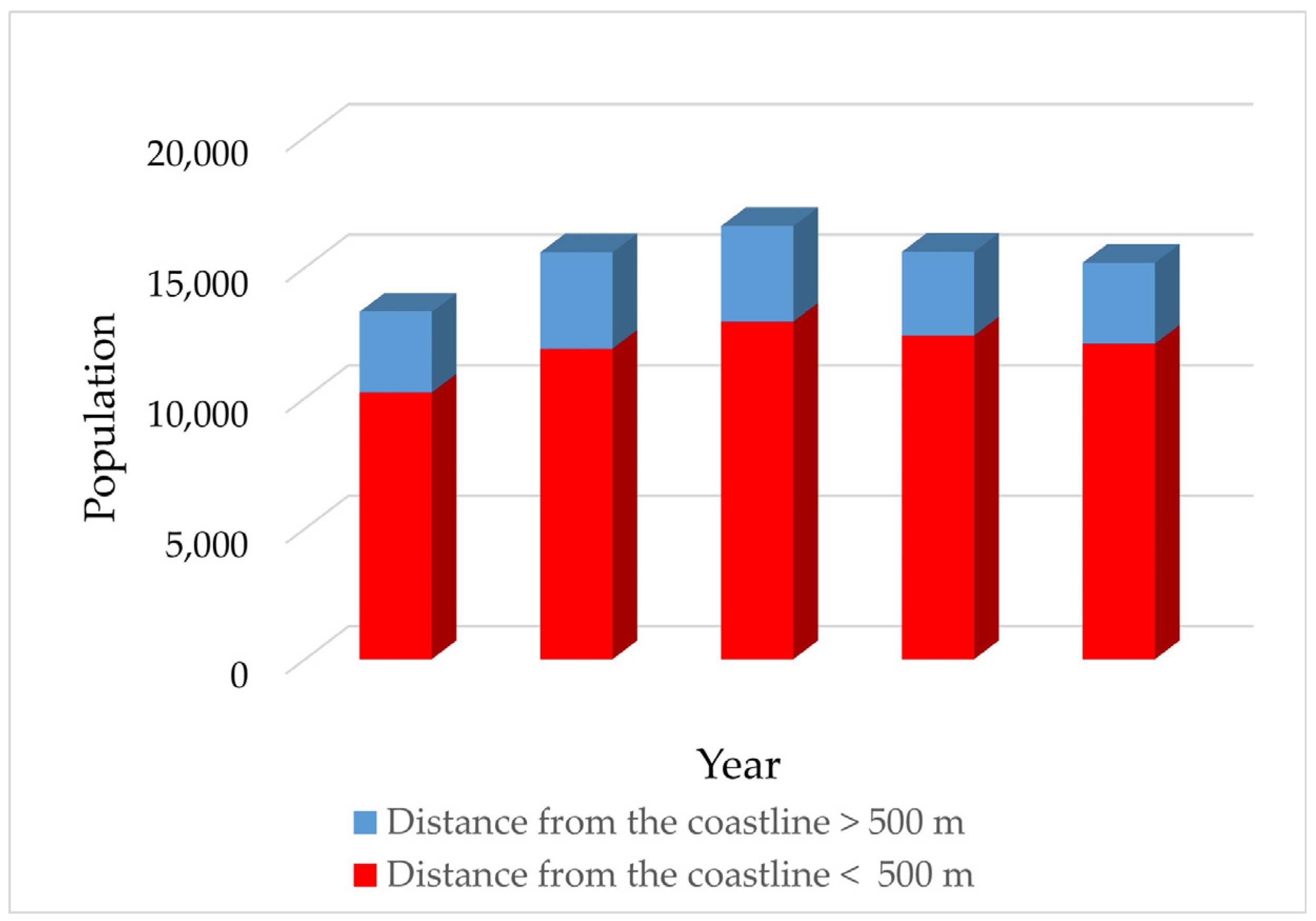
According to the Hellenic Statistical Authority [45], Sithonia covers an area of 514.7 km2 and has a population of 12,080 (Census data 2021). The study area’s population increased by 1869 inhabitants from 1981 [46] to 2021 [45]. Figure 2 shows the population of settlements located more and less than 500 m from the coastline. The coastal part of the region contains many large hotels and camping grounds, with the majority of the latter located in the south [47].
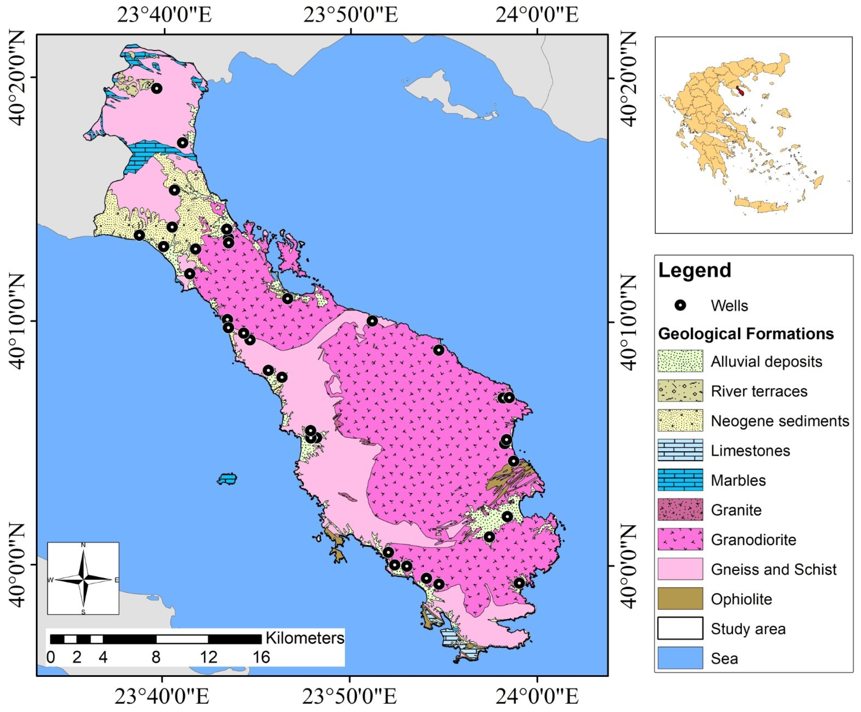
The geological formations of the study area are shown in Figure 3. The main part of the peninsula belongs to the Circum Rhodope Belt, which is mainly composed of Mesozoic sedimentary and metavolcanic rocks [48]. Specifically, Sithonia is formed of sedimentary rocks, metamorphic rocks of the Perirodopic Zone, gneisses and amphibolites of the Serbo-Macedonian Massif, and acidic igneous rocks, namely Sithonia granodiorite. A small part of the Serbo-Macedonian Massif consists mainly of amphibolites and gneisses [48]. The largest area is occupied by the 40 Ma old granodiorite of the Sithonia Plutonic Complex (SPC), which is compact in many areas and appears to be mostly decomposed. A smaller proportion of the area is covered by Quaternary and Neogene sediments.
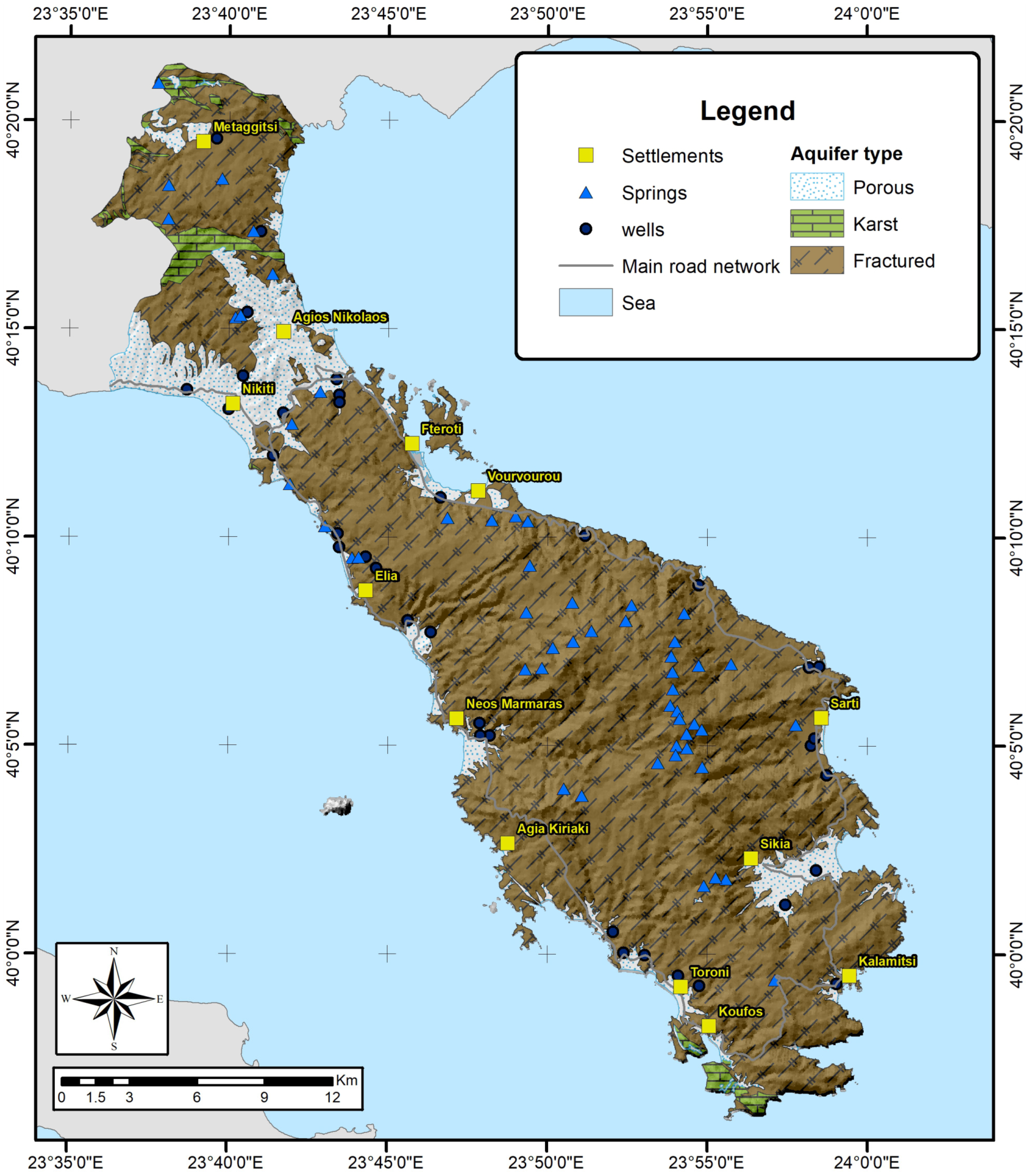
Fractured, karst, and porous aquifers are present within the study area, while fractured rock is the dominant aquifer [49] (Figure 4). The porous aquifers are insufficient, and the karst aquifers cover just a small area. The majority of wells and springs occur within the fractured rock aquifer. The springs have insufficient discharge and hence do not contribute to the water supply of the area. The fractured rock aquifer has developed within granodiorite and metamorphic rocks, while porous aquifers are mainly present in coastal zones and are characterized by a high degree of heterogeneity, resulting in variations in hydraulic parameters [49]. The fractured rock aquifer is characterized by high heterogeneity in terms of hydraulic parameters and flow rates. The discharge rates of existing wells vary between 5 and 35 m3/h. The transmissivity of the aquifer ranges between 4.7 × 10⁻⁶ m/s2 and 3.82 × 10⁻⁵ m2/s.
According to the European Environment Agency (Corine Land Cover 2018 [50]), the majority of the area is covered by shrub and herbaceous vegetation, forests, and crops, while olive groves and vineyards cover 10.7%. Based on the River Basin Management Plans of the Central Macedonia Water Department [51], the primary sources of pollution often stem from the discharge of leachate into groundwater, particularly from aging landfills, olive oil mills, and livestock farms. The uncontrolled disposal of waste in landfills results in leachates that end up in groundwater and significantly degrade its quality. It is worth noting that the Peninsula of Sithonia does not operate a landfill site, but there is a waste transfer station in Nikiti. A moderate 27% of the area’s municipal solid waste is taken to the landfill of Poligyros, and the remaining 73% is taken to Anthemountas’ landfill site. The salinization of groundwater is mainly noticeable during the summer months due to the high levels of tourist activity. This phenomenon is observed primarily in the Neos Marmaras, Sarti, Agios Nikolaos and Toroni regions. The wastewater treatment plants in Sithonia contribute to improving the environmental status of water bodies. Existing wastewater treatment plants are noted in Nikiti, Neos Marmaras, Sarti, Agios Nikolaos, and Sikia, where they receive significant pollutant loads [51].
Figure 3. Geological map of the study area (Hellenic Survey of Geology and Mineral Exploration (HSGME) with modifications, scale 1:50,000, sheets: Arnea and Sithonia [52]).
Geosciences 15 00024 g003
Figure 4. Hydrogeological map of the study area.
Geosciences 15 00024 g004

3. Materials and Methods

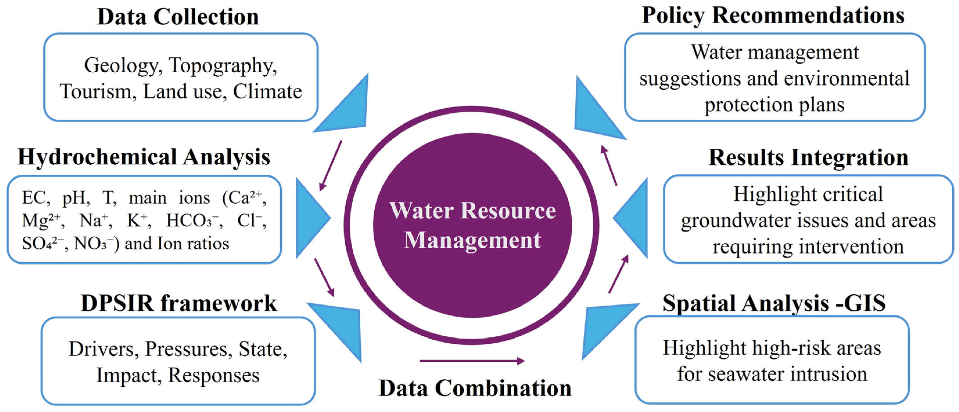
The methodology includes a combination of qualitative and quantitative data, and a flowchart of the research steps is presented in Figure 5. Initially, the hydrological balance was compiled using data from the meteorological station of Neos Marmaras (data obtained from www.meteo.gr (accessed on 10 January 2021). Groundwater level measurements and lithological profiles were collected and analyzed to determine the hydraulic characteristics of the aquifers. Chemical analysis data were obtained from previous studies, which provide data from the years 2010, 2018, 2019, and 2020, in order to compare hydrochemical evolution [49,53]. In total, thirty-six samples were elaborated, and these were obtained from boreholes selected based on the judgmental sampling approach [54].
Chemical analyses of the main ions EC, Ca2+, Mg2+, Na+, K+, HCO3, Cl, SO42−, and NO3 and trace elements As, Cr, Mn, and Fe were used for this study. Specifically, chemical data were used for the calculation of the ion ratios Na+/Cl, Cl/SO42−, Mg2+/Ca2+, Na+/K+, and (Ca2+ + Mg2+)/(Na+ + K+). Na+/Cl and Cl/SO42− were used to determine the extent of the seawater intrusion phenomenon, while Mg2+/Ca2+ was used to determine the groundwater regime from calcareous or magnesian rocks. Na+/K+ was used to indicate the origin of groundwater, while (Ca2+ + Mg2+)/(Na+ + K+) was used to determine groundwater recharge or discharge zones. The sampling points were categorized as high, average, low, and very low indicators for seawater intrusion, associated with the sum of three factors: EC, Na+/Cl, and Cl/SO42−. The values range from 0 to 3, with the highest value indicating the possibility of seawater intrusion in the aquifer (Table S1). Based on the literature, seawater intrusion is indicated by specific threshold values for certain parameters: EC values exceeding 2500 μS/cm, Na+/Cl ratios below 1, and Cl/SO₄2− ratios greater than 10 [55].
The DPSIR framework was utilized to understand the status of the study area’s water resources under various pressures. This approach allowed for the systematic evaluation of (i) environmental drivers such as land use and climate change, (ii) pressures, namely pollution and overextraction, (iii) the current state of existing water resources, and (iv) resulting impacts on ecosystems and human activities. The DPSIR framework also aided in the formulation of appropriate response strategies to mitigate these issues and improve water management.
Spatial distribution maps were created using Geographic Information Systems (GISs) to depict the hydrochemical characteristics of groundwater using data obtained from relevant hydrogeological studies of the study area by the Hellenic Survey of Geology and Mineral Exploration (HSGME) [56,57]. Point and diffuse pollution sources were identified with the aid of previous studies [51] and fieldwork. These data were used to implement the DPSIR framework for water resource management.
Finally, the methodology focused on specific issues needing investigation and the drawing up of protection plans. Regions identified as under high pressure were provided based on land use and the results of the groundwater chemical analysis.

4. Results and Discussion

4.1. Groundwater Quality

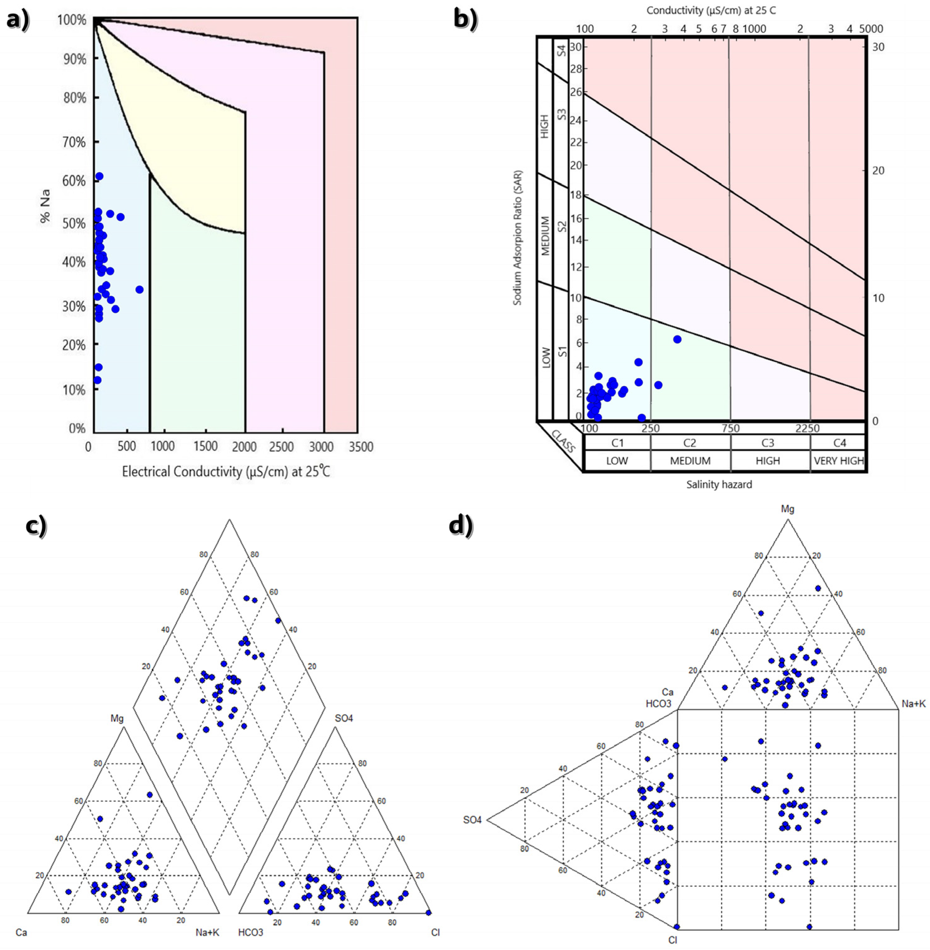
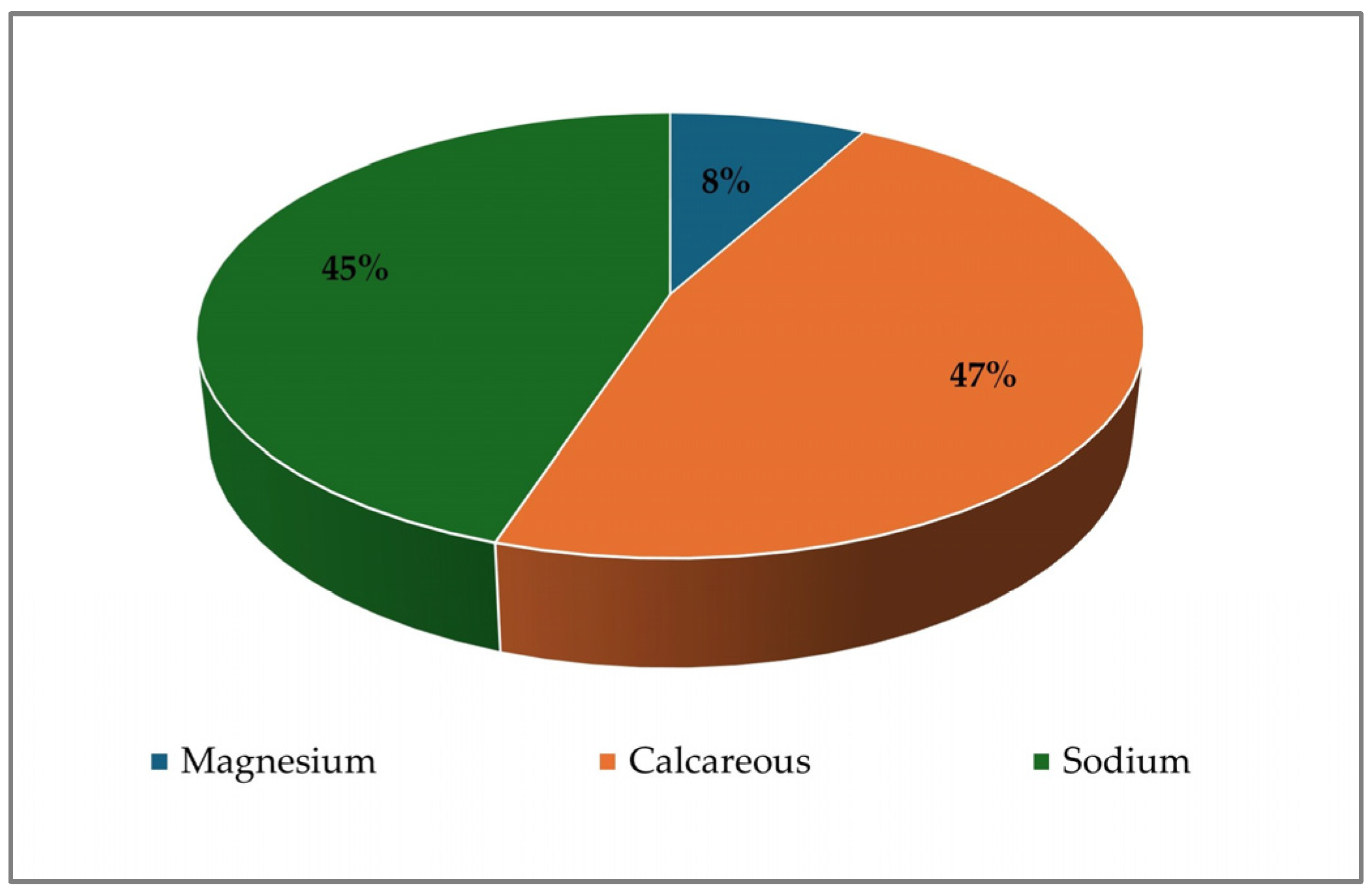
The chemical analysis of groundwater quality is crucial to determine its origin and suitability. The chemical composition of groundwater depends primarily on the geological formations through which the water passes and the time it spends in the aquifer [58]. In this study, thirty-six (36) groundwater samples were analyzed using Piper and Durov hydrochemical diagrams to determine water types based on the main ions Ca2+, Mg2+, Na+, K+, HCO3, SO42−, Cl, and NO3 (Figure 6). Both diagrams were produced using the AquaChem program. Wilcox and SAR diagrams were created to determine the quality and salinity hazard of the water (Figure 6). The dominant groundwater types in the study area are Ca-Na-Cl-HCO3, Ca-Na-HCO3-Cl, and Mg-K-HCO3. Figure 7 shows the main chemical types of water with the highest concentrations of sodium and calcium. In coastal regions, the Ca ± Na ± Mg-HCO3 ± Cl ± SO4 type is typical, indicating a mix of meteoric water with seawater. Based on the chemical analyses, the concentration of calcium ions ranges from 5.3 to 400.8 mg/L, and that of magnesium ions varies from 3.4 to 163.0 mg/L. The concentration of sodium ions ranges from 3.0 to 420.0 mg/L, and that of potassium ions ranges from 2.0 to 256.2 mg/L. The concentration of bicarbonate ions ranges from 28.0 to 453.9 mg/L, sulfate ranges from 2.0 to 257.0 mg/L, and nitrate ions range from 2.0 to 16.9 mg/L (Table 1). These results are in agreement with the data published by YPEKA [59] for the study area (Figures S1 and S2). In addition, the chloride concentrations of the groundwater samples range between 13.0 and 1453.9 mg/L (Figure S3). The highest concentrations are observed in the southeastern and northwestern parts, mainly in porous aquifers due to overexploitation. Based on data collected by HSGME [49] and YPEKA [59], a significant groundwater level occurred up to 20 m in the Toroni region during the period of 2006 to 2020.
Recent chemical analyses revealed higher nitrate concentrations due to olive mill wastewater [47]. Of the heavy metals, arsenic and chromium were within normal limits, while iron and manganese values reached 1950.0 and 921.0 μg/L, respectively. The high concentrations of calcium, magnesium, sodium, potassium, and chlorine noted in the study area indicate salinization phenomena [60]. Sulfate ions were found to be within normal limits, and the high concentrations of iron and manganese (Figure S4) were attributed to minerals (amphiboles, biotite, etc.) from the local rocks and the phenomenon of salinization due to overpumping, which led to water quality deterioration in the study area. Chromium concentrations were within the acceptable limits for drinking water according the World Health Organization (WHO) (<50 μg/L) [61]. The Mg2+/Ca2+ ionic ratio results (Table 2) show that the study area comprises predominantly calcareous rocks. The groundwater in the study area appears to be supplied continuously, as it shows ionic ratio (Ca2+ + Mg2+)/(Na + + K+) values greater than one. A large part of the study area exhibited a Na+/Cl ionic ratio of less than one due to salinization, as well as Na+/Cl ratio values < 1 and Cl/SO42− ratio values > 10, thus indicating a seawater-affected zone (Table S2). Samples with high EC values near a Na+/Cl ratio of 0.86 (red line) are assumed to be influenced by seawater intrusion, while higher values of this ratio indicate anthropogenic inputs and/or freshwater mixed with seawater (Figure 8a). In addition, elevated Ca2+/Mg2+ ratios (>1) may indicate freshwater influence, ion exchange, or mineral dissolution processes (Figure 8b). Low Na+/Cl ratios suggest other possible sources of salinity, such as local pollution [62].

4.2. DPSIR

The DPSIR framework is shown in Table 3. The analysis of the DPSIR method includes (i) driving forces, (ii) pressures in the study area that are a direct result of these driving forces, (iii) the results derived from the pressures (state), (iv) the impacts on people and the environment, and (v) the measures that need to be considered to handle the situation (responses). Eight (8) drivers are noted as occurring within the area: protected areas, urban development, tourism, climate, topography, geology, agriculture and livestock, and industrial activity [47,51,63].

4.2.1. Protected Areas

Based on Natura 2000 data, approximately 82.9% of the Sithonia Peninsula is considered a protected area, with limits on tourism and other human activities. This has resulted in an uneven distribution of settlements and tourism. The existence of these protected areas aims to ensure (i) the quality of groundwater and its protection from pollutants, (ii) less problems in meeting the water supply demands and irrigation needs of neighboring settlements, and (iii) the crowding of most settlements and tourists in coastal areas. The consequences include a reduction in water availability, the pollution and contamination of underground aquifers, and groundwater salinization. To address these issues, it is essential to prevent the dispersal of pollutants from various sources, ensure the proper use of fertilizers and irrigation water, and drill new shallow wells to maintain groundwater quality.

4.2.2. Urban Development

The DPSIR analysis results indicate that urban development is a driving force for the Peninsula of Sithonia. The main pressures in the area are (i) water supply, mainly during the summer months due to tourism, (ii) the inadequate operation of existing wastewater treatment plants, (iii) the failures of the sewerage network, mainly due to its age, (iv) the absence of landfills in the study area, and (v) the lack of controlled aggregate disposal sites [64].
Groundwater salinization is the main environmental impact of these pressures, resulting from groundwater overpumping to meet water supply demands. In addition, the intense pollution of groundwater and marine waters from anthropogenic activities, the degradation of the River Havria by wastewater originating from Metaggitsi Olive Mill [47], the deterioration of water quality in local streams and brooks, and summer wildfires caused by the illegal dumping of waste have also had a significant environmental impact. Thus, additional monitoring measures are needed to address the effects of urban development. Responses include reducing wasted drinking and irrigation water by modernizing municipal water supply systems and irrigation networks, detecting leaking pipes, and continuously monitoring existing water supply networks.
Other responses involve the removal of boreholes from the coast and the improvement and replacement of aging infrastructure in sewerage systems, wastewater treatment, and waste disposal facilities. There is an urgent need to create new biological wastewater treatment systems, especially in Metaggitsi. The rational management of liquid and solid waste can be achieved through constructing a landfill and biological treatment facilities to prevent water quality degradation. In addition, it is essential to raise awareness among citizens about protecting the natural environment and limiting wasteful use of water resources and to encourage the recycling and reuse of materials. Finally, it is vital to encourage people to participate in new recycling programs and use appropriate bins for the proper collection of municipal solid waste.

4.2.3. Tourism

The study area is subject to considerable tourism pressure, particularly due to the substantial seasonal population increase in the coastal regions during summer [65]. The number of visitors on the site increased from 100.000 during 2010 to 200.000 during 2023 [65]. The water demands for tourism during 2023 reach up to 300.000 m3/year. The overexploitation of aquifers exerts additional pressures due to increased water demands and the extensive infrastructure built near the coastal zone. Groundwater overexploitation can also be detected through fluctuations in the groundwater level. However, there is a lack of data regarding the exact population increase during the summer, making it difficult to estimate the peak water demand. Consequently, managing groundwater becomes challenging during the summer, and the quality of groundwater deteriorates due to the absence of proper biological wastewater treatment systems in large hotels and campsites. The environmental impacts of these pressures include problems with seawater intrusion due to the overexploitation of coastal aquifers as well as significant pollution of surface and groundwater from large hotels and campsites caused by cesspools, waste, and sewage. In response to these challenges, the rate of visitors per year can provide important information regarding variations in water consumption in the study area.
Two key management actions can be implemented in response to these challenges: (i) the statistical monitoring of tourist numbers and (ii) the establishment of protection zones. The creation of protection zones aims to limit human activities to mitigate environmental degradation caused by increased tourism. Additionally, the annual statistical counting of tourists provides valuable data for assessing tourism trends and pressures on the environment. This monitoring enables authorities to adjust management strategies and implement sustainable tourism practices, ensuring a balance between tourism development and environmental conservation.

4.2.4. Climate

Climate variability acts as a key driver, leading to several environmental challenges, including an inadequate weather analysis system and issues in the management of water resources [66]. The insufficient capacity of weather analysis systems hampers the ability to predict and respond to extreme meteorological phenomena like heavy rainfall, heat waves, and drought, which exert pressures in the study area. Another pressure is the occurrence of fires, mainly during dry periods of the year, due to drought and high temperatures [67,68]. These events lead to crop damage, desertification, and flooding. Ineffective water management strategies and changing precipitation patterns lead to increased water scarcity and the overexploitation of resources. To address these issues, it is recommended that new meteorological stations and stream flow meters be installed in suitable locations to improve data monitoring and collection. There should also be a focus on monitoring water quality after heavy rainfall, utilizing treated wastewater, and artificially enriching groundwater.

4.2.5. Topography of the Area

The topography of the current study area plays a significant role. Several pressures are noted on the Peninsula of Sithonia, such as the high altitudinal heterogeneity, the absence of major rivers, erosion and sediment deposition caused by small streams, and seawater intrusion due to low-altitude and lowland areas in most of the study area. These pressures result in disturbances in the balance of erosion and deposition processes, the predominance of surface runoff over downstream runoff, the discharge of water from watercourses into the sea due to the morphological gradient, and severe flooding phenomena. These pressures also cause the deposition of sediment near the coast, seawater intrusion, and large volumes of unused water being discharged into the sea, impacting the primary production sector. To address this, it is suggested that flood protection structures and small dams be constructed to exploit surface water and recharge groundwater systems.

4.2.6. Geology

The high concentrations of iron and manganese in the groundwater samples from this study area are attributed to the presence of granodiorite rocks [47]. In addition, metamorphic rocks, such as gneisses and amphibolites from the Serbo-Macedonian Massif, affect the region’s hydrogeology conditions due to their fractured nature. The area also contains sedimentary formations in the coastal area, while carbonate rocks occur in small sites. The predominance of rocks with secondary porosity selectively favors precipitation and the selective circulation of surface water. This situation affects inhabitants and reduces crop yields. These geological formations are important drivers as they directly influence the quantity and quality of groundwater. To address these challenges, detailed hydrogeological research is recommended to determine the optimum positions for drilling new water supply boreholes and establishing a larger network of monitoring wells.

4.2.7. Agricultural and Livestock Activity

According to the land use map, the study area consists of numerous livestock farms, olive mills, and arable lands (Figure 9). Olive mills close to Havria River discharge their wastewater directly into the river. Some of this wastewater percolates into the groundwater, while most ends up in the sea, leading to the deterioration of water and habitats in the Toronean Gulf. This conclusion can be drawn from the elevated NO3 values, ranging from 1.2 to 54.1 mg/L, recorded in previous research publications [47]. However, the chemical analyses in this work measured a range of NO3 concentrations from 2.0 to 16.9 mg/L. Higher NO3 concentrations in groundwater occur in the northwest part of the study area (Figure S5). These areas are occupied by olive groves, where nitrogen fertilizers are typically applied to enhance fruit production. According to previous studies, driving pressures in the study area include the presence of untreated livestock effluent and mill effluent, which end up in streams that eventually discharge them into the sea, the use of fertilizers and pesticides, the lack of irrigation systems, and difficulties in water management during the summer months due to tourism. Consequently, water is mainly consumed for agricultural and domestic use [63]. During the summer, there is a significant increase in visitors to the peninsula, leading to higher water demand [65]. Land use exerts pressure in the study area, affecting the quantity and quality of groundwater.
Important proposed solutions include educating farmers about the value of rational fertilizer and pesticide use and the construction of biological treatment facilities to improve the disposal of wastewater from olive mills. Proposed solutions also include the construction of a dam in the River Havria, which will contribute significantly to irrigation needs, the construction of smaller dams at higher elevations to meet water demands and irrigation needs, attempts to create new irrigation schemes and estimate the quantities of water required for irrigation, and the implementation of stricter controls on the construction of new water intake projects and the expansion of existing ones. Finally, the process of groundwater artificial recharge can be applied where necessary, along with improving irrigation and land reclamation infrastructure. In response to these challenges, small dams have already been constructed to address the water supply issue, and protection zones have been established around boreholes that exhibit declining water quality [63].

4.2.8. Industrial Activity

The study area is significantly affected by industrial activity, including the operation of olive mills and quarries. Fieldwork has revealed that the wastewater treatment plants in the study area need immediate intervention and improvement, as their output flows are not adequately treated. Therefore, it is important to upgrade these treatment facilities, prohibit the direct disposal of untreated industrial wastewater into streams and waterbodies, control industrial waste management, and establish appropriate infrastructure to treat specific wastewater generated by local industries.

4.3. Hydrochemical Analysis and DPSIR Framework

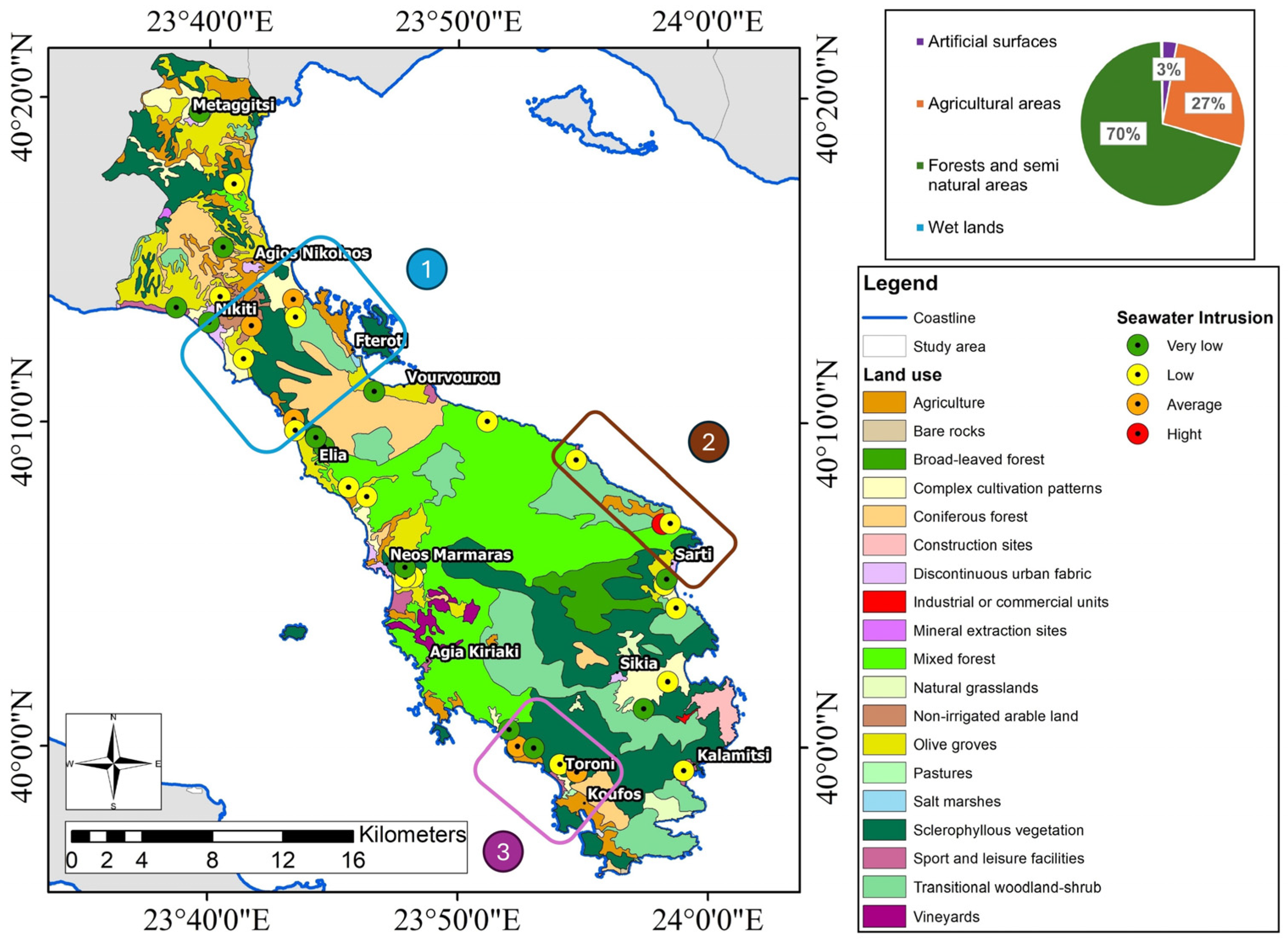
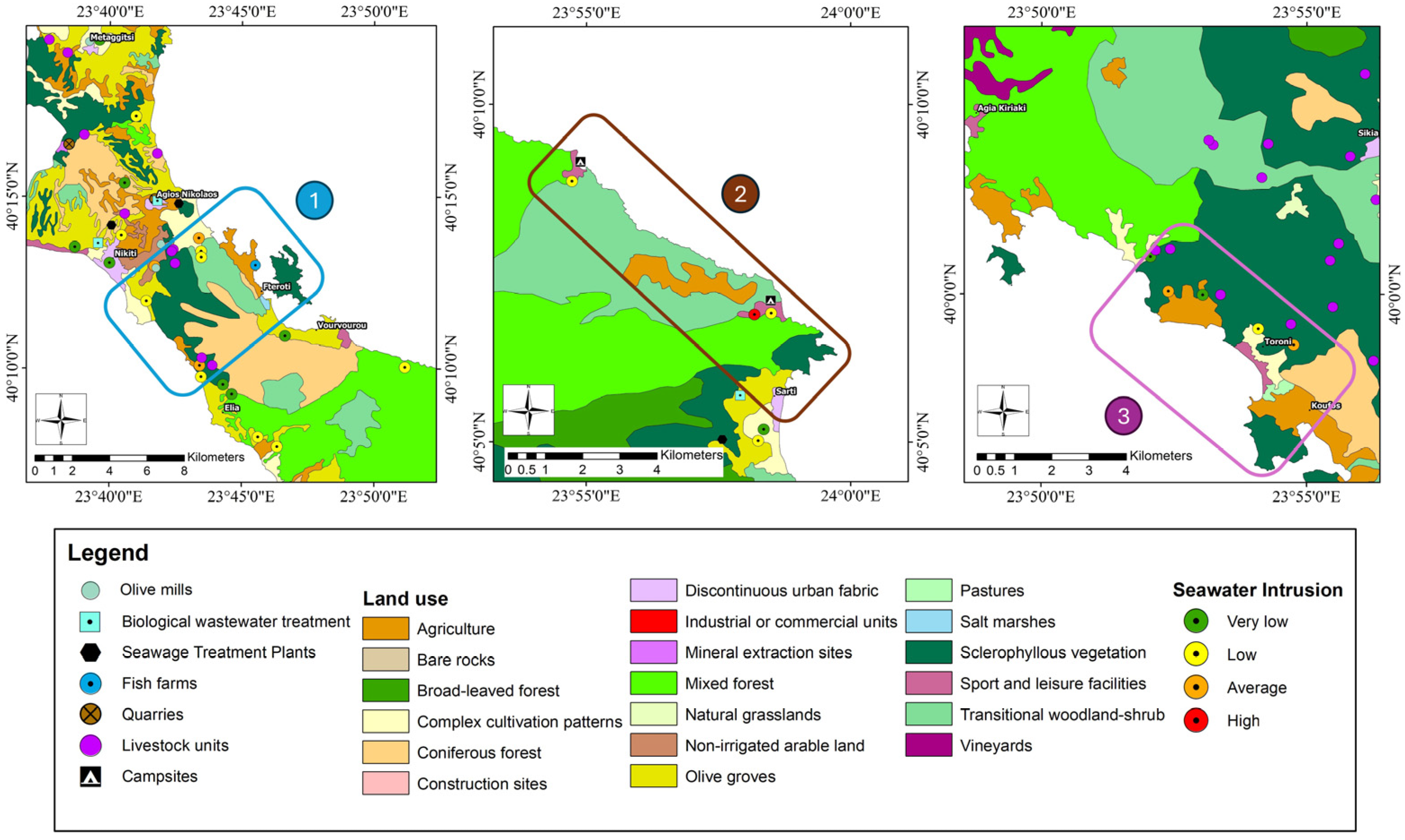
Figure 9 and Figure 10 present the results of the land use assessment based on DPSIR analysis and groundwater quality affected by seawater intrusion in the sampling wells. The groundwater chemical analyses indicate that three areas require immediate intervention. The first is covered by alluvial sediments, vegetation, agricultural land, and olive groves. The electrical conductivity values at this site are high and vary from 639 to 2330 μS/cm, while the Na+/Cl and Cl/SO42+ ionic ratios indicate salinization phenomena with values of 0.12 and 16.9, respectively. The pressures recorded in Area 1 are geological formations due to the presence of alluvial sediments and granodiorites, olive mills, dumpsites, and fish farms. Based on the groundwater chemical analyses, Area 2 is affected by seawater intrusion, with high values of electrical conductivity up to 3700 μS/cm and Na+/Cl ionic ratios below 1. The pressures observed in Area 2 are campsites in Platanitsi and Armenistis, where special attention should be paid due to increased water needs during the summer months. Alluvial sediments and granodiorites are also noted in Area 3. Based on the land use map, vegetation and agricultural land cover the main part of the area. The groundwater samples taken from the area’s monitoring wells show high electrical conductivity values varying from 425 to 6450 μS/cm, as well as Na+/Cl values indicating salinization phenomena with values between 0.34 and 1.24. The pressures in Area 3 are agricultural activities, which affect the quality and quantity of groundwater, and tourism. Monitoring wells are located in the coastal zone and are directly affected by seasonal excess water demands.

5. Discussion

Coastal areas are greatly affected by high levels of tourism [69]. Solid waste and a high demand for water cause water stress in these vulnerable areas. In this case, the deterioration of freshwater resources in terms of quantity and quality has been noted [70], and the climate crisis exacerbates the situation [71]. Ultimately, integrated coastal zone management is crucial for the long-term environmental and economic stability of coastal resources [72]. In this regard, a systematic review of integrated solid waste management (ISWM) strategies is provided by Herrera-Franco et al. [73], where the definition of criteria for the optimum monitoring method management approach is discussed. Their strategic approaches consider relevant factors such as geological formations, environmental protection zones, and human activities. This involves a detailed analysis of the region’s natural resources, the hydrogeological regime, and the impact of urban, industrial, and agricultural development [74] to understand the risks and limitations of each study area. Overall, a holistic research approach, including detailed analyses of these factors, can provide essential insights for integrated decision-making processes [75]. The monitoring network should be designed to align with the distribution of “hot spots” identified by the spatial concentration of high-priority criteria rather than being evenly distributed across the entire study area. With this in mind, different research approaches have been conducted [42,76,77].
However, there is a lack of scientific studies on the influence of fracture characteristics on seawater intrusion. Sebben et al. [78] applied numerical modeling as a primary step to investigate the impact of fracture orientation location on the extent of wastewater and associated patterns. Another research approach by Masciopinto and Palmiotta [79] followed a 3D methodology analysis to assess saline front advancement in a fractured coastal aquifer. In all cases, collecting data based on both the literature and fieldwork is of utmost importance for the investigation of the hydrogeological regime of an area.
The current research approach constitutes the initial research stage before applying feasible modeling methodologies to investigate the vulnerable zones within a study area. Vulnerability maps are crucial tools for identifying high-risk areas in environmental management [80]. An example of a published research approach for investigating seawater intrusion vulnerability based on the GALDIT method in the Gulf of Sarti (Greece) is provided by Kazakis et al. [81]. This groundwater vulnerability map was derived by combining six parameters—groundwater occurrence (G), aquifer hydraulic conductivity (A), groundwater head, altitude above sea level (L), distance from the shore (D), impact of the existing status of seawater intrusion (I), and the thickness of the aquifer (T)—to identify and prevent the salinization of the aquifer.
Water–rock interactions are crucial for determining groundwater quality [82]. In the study area, the chemical composition of groundwater is mainly influenced by these interactions, particularly through the decomposition of the dominant silicate rocks. In coastal regions, elevated sodium and chloride concentrations, along with Na+/Cl ratios below 1, indicate the influence of seawater intrusion driven by overpumping [83]. The high variability of magnesium and potassium levels suggests contributions from the dissolution of metamorphic and granodioritic rocks [84]. Furthermore, elevated nitrate levels in specific locations point to anthropogenic influences, particularly agricultural runoff and olive mill waste, affecting groundwater quality. These observations underscore the interplay between geological formations, natural processes, and human activities in shaping groundwater chemistry.
To overcome these challenges, in recent decades, the DPSIR framework has been applied widely in coastal areas to assess and manage environmental and socioeconomic issues. Gari et al.’s [85] review of the application and evolution of the DPSIR framework, with a focus on coastal social–ecological systems, provides an in-depth analysis of how DPSIR analysis has been adapted and utilized in various coastal contexts around the world. Drivers, such as tourism and urbanization, create pressures like pollution, habitat destruction, and water resource depletion. Population growth has been analyzed in Qatar at a country scale, with high water scarcity [25], followed by an increase in desalinated water production. Additionally, urbanization was investigated as a driver by Jago-on et al. [86] in Asian cities, while Moss et al. [87] implemented DPSIR analysis to assess climate change in ecosystems in the UK. Obviously, the DPSIR framework is suitable for application at both the country and aquifer scales and provides valuable information. The results of this study focus on aquifer-scale applications in accordance with the existing literature. According to Zhai et al. [88], elevated Fe and Mg concentrations correlate with climate parameters, surface features, and hydrogeochemical characteristics in the Songnen Plain, affecting the groundwater quality. These elements have also been found in lower concentrations in the study area, varying among different geomorphic units, and are influenced by soil properties and aquifer characteristics, which determine the sources of these elements. In addition, the unsustainable extraction of groundwater significantly deteriorates its quality, which is a concern that has been highlighted by numerous research studies from various parts of the world [89,90]. The Sithonia region is also facing serious problems due to this worrying trend, where the local ecosystem and community health are being affected. Olive mill wastewater contains large quantities of organic matter, which degrades groundwater when discharged untreated into adjacent streams [91]. This situation is also observed in the study area, where the extraction of olive oil produces large amounts of waste that possesses high phytotoxicity.
According to Lumb et al. [92], water quality indices (WQIs) are a valuable tool for the continuous monitoring of water quality. In this respect, the combination of water quality indices (WQIs) and the DPSIR framework can provide reliable results for assessing groundwater and implementing optimal management plans. Alexakis [44] applied DPSIR analysis and WQIs in a coastal area in Greece to help formulate sustainable development plans for an alluvial aquifer. Song and Frostell [93] have also implemented this approach in surface waterbodies, focusing on integrating DPSIR analysis into a pressure-oriented approach to water quality monitoring for ecological river restoration. Consequently, coupling DPSIR analysis and water quality has already been applied in the literature. In this study, this approach was innovatively applied to a fissured rock aquifer in a touristic coastal area in Greece. More specifically, this study followed a methodology based on the concept of a GIS environment to delineate high-priority areas for coastal zone management plans. A simplified pattern was followed based on two criteria: (i) the DPSIR framework and (ii) the seawater index, based on groundwater chemical analysis. In this case, the ion ratio score of the chemical analysis was determined to define high-risk areas. The application of DPSIR analysis demonstrates the necessity of implementing certain measures to improve current conditions in water resource management. Following this methodology, three high-priority areas were found to require groundwater protection due to the high risk of seawater intrusion and the impact of human activities.
Based on the current findings, the construction of biological wastewater treatment systems will serve all settlements in the Peninsula of Sithonia and help avoid the degradation of groundwater quality. The illegal dumping of waste and rubbish in steeply sloped areas and the absence of a municipal wastewater treatment plant within the study area are notable, especially during dry months, when the population rapidly increases. Therefore, it is necessary to construct and operate a suitable sanitary landfill as well as installing appropriate waste bins to encourage recycling and the protection of the natural environment [78]. The second threat in the study area is groundwater quantity depletion. The imbalance between supply and demand leads to significant variations in the groundwater level during the summer months due to excessive pumping. The water demand for the permanent population is about 0.7 × 10⁶ m3/year, while for touristic activities, it is 0.3 × 10⁶ m3/year. In order to meet this demand, overpumping in some areas has led to a groundwater decline of more than 20 m in one decade. In this case, the application of managed aquifer recharge using treated wastewater or water from small dams constitutes a solution, as does aquifer storage and recovery (ASR), including the injection of water into a borehole for storage and pumping [8,94].
In recent decades, a high number of flood events have been recorded during the autumn in central Macedonia [95]. Urban floods are a growing concern due to inadequate drainage systems and blocked river channels [96], as well as the evident climate crisis. These extreme events occur within a concise timeframe; however, they can cause significant disasters and threaten human life. Sensitivity analysis based on the multicriteria index method can provide significant information about flood vulnerability at a river basin scale [80,97]. In these cases, the results are determined from the quantity of data collected. Thus, for the optimum application of this method, installing a monitoring network combining river gauging and meteorological stations in an appropriate spatial distribution is crucial.
Despite the valuable insights provided by the results of this study, several limitations have been recognized. The number of collected water samples might be non-representative; however, water sampling points are limited in the study area. Obviously, new sources of groundwater should be determined to support the area’s increasing water demands and simultaneously increase its monitoring network. When hydrogeological data are scarce, the DPSIR framework can provide valuable information on groundwater management [42]. The application of the DPSIR framework at several sites and a cross-comparison of the results are strongly suggested to obtain common strategies and solutions in high-tourism sites. Additionally, groundwater depletion was considered in the DPSIR analysis of the study area, and the numerical modeling of groundwater will be performed in future research. For instance, Malmir et al. [34] applied MODFLOW to determine the effectiveness of DPSIR responses. Numerical modeling could enrich the current results and provide more information about current and future variations in groundwater quality and quantity. A multivariable statistical analysis using cluster and principal component analyses could be carried out in the future, with more samples for improved accuracy.
The lack of socioeconomic analysis, including the costs and policy challenges of implementing the proposed responses, may limit the practical applicability of the recommendations produced when applying DPSIR analysis. However, no data on variations in tourism over time are available for the study area’s subregions. Applying the DPSIR framework across multiple sites with cross-comparative analyses is strongly suggested to develop common strategies for high-tourism regions. In future research, the combination of DPSIR analysis with other methodologies will be implemented. Additionally, the interaction of air pollution [98] with water resources could be included in a future application of DPSIR analysis at sites with available data.
A variety of methods can improve DPSIR analysis, for instance, the entropy weight method, analytic hierarchy process (AHP), and comprehensive index evaluation method [70,99]. Pacheco et al. [100] used a coastal management program (CMP) based on the DPSIR framework and the integrated coastal management (ICM) cycle for the management of channels located in back-barrier systems. Hou et al. [101] adopted the Driving Force–Pressure–State–Impact–Response–Management (DPSIRM) model and used hierarchical analysis and entropy value methods to determine the weights and comprehensively evaluate the ecological security of wetlands. The entropy weight method (EWM) is a widely used weighing approach for assessing value dispersion in decision-making [99]. The analytic hierarchy process (AHP) is a practical and successful method for the qualitative and quantitative study of indicators. It divides influencing aspects of a research object into separate groups based on their closeness. The analytic hierarchy process and entropy weight technique decrease the impact of subjective and objective factors [101].

6. Conclusions

The DPSIR model was combined with the hydrochemical data and water quality indices of groundwater samples in the fractured rock aquifer of Sithonia Peninsula in North Greece. The main conclusions of the study can be summarized as follows:
The main pressures in the study area are the geological regime, the presence of biological wastewater treatments, illegal dumpsites, olive mills, tourism, and livestock activities.
Na+/Cl and Cl/SO42− ion ratios range from 0.12 to 1.48 and 0.91 to 186.58, respectively, and indicate the seawater intrusion phenomenon.
These ion ratios indicate a high possibility of seawater intrusion in three areas of the coastal zone. The main pressures in Area 1 are geological formations. In Area 2, tourism is the main driver, and in Area 3, livestock units, tourist accommodations, and hotels affect groundwater systems.
Water obtained from boreholes is limited in the fractured rock aquifer of Sithonia due to the site’s hydrogeological regime. Therefore, the borehole network must be extended in order to ensure water security.
The following proposals could contribute to the improvement of groundwater protection and sustainability:
  • Establishing a monitoring network to record hydrometeorological parameters and expand the groundwater monitoring network in collaboration with key stakeholders.
  • Developing biological wastewater treatment systems, wastewater treatment plants, and proper olive mill wastewater management to prevent surface water degradation in the study area.
  • Establishing a landfill site to improve local waste management services, particularly during the summer tourism season.
Combining DPSIR analysis with the water quality index constitutes a valuable approach for sustainable groundwater management at tourist sites. This approach is flexible and strongly suggested to be applied to additional sites in order to compare results on a global scale.

Supplementary Materials

The following supporting information can be downloaded at https://www.mdpi.com/article/10.3390/geosciences15010024/s1: Table S1: Distribution of different seawater intrusion values, Table S2: Range of values for indication of seawater intrusion. Figure S1: Classification of groundwater samples from Toroni and Elia Nikitis monitoring points in Piper diagram. Figure S2: Variation in EC and GWL values in the monitoring well in Elia Nikitis. Figure S3: Spatial distribution of the Cl values in the study area. Figure S4: Spatial distribution of the Mn values in the study area. Figure S5: Spatial distribution of the NO3 values in the study area.

Author Contributions

Conceptualization, E.P., M.M.N. and N.K.; methodology, E.P. and M.M.N. validation, N.K. and F.-K.P.; formal analysis, E.P. and N.K.; investigation, E.P. and N.K.; data curation, E.P. and M.M.N.; writing—original draft preparation, E.P.; writing—review and editing, M.M.N., F.-K.P. and N.K.; visualization, E.P., M.M.N. and N.K.; supervision, N.K. and F.-K.P. All authors have read and agreed to the published version of the manuscript.

Funding

This research received no external funding.

Data Availability Statement

The original contributions presented in the study are included in the article, and further inquiries can be directed to the corresponding author.

Conflicts of Interest

The authors declare no conflicts of interest.

References

  1. Gössling, S. Global Environmental Consequences of Tourism. Glob. Environ. Change. 2002, 12, 283–302. [Google Scholar] [CrossRef]
  2. Cosgrove, W.J.; Loucks, D.P. Water Management: Current and Future Challenges and Research Directions. Water Resour. Res. 2015, 51, 4823–4839. [Google Scholar] [CrossRef]
  3. Drius, M.; Bongiorni, L.; Depellegrin, D.; Menegon, S.; Pugnetti, A.; Stifter, S. Tackling Challenges for Mediterranean Sustainable Coastal Tourism: An Ecosystem Service Perspective. Sci. Total Environ. 2019, 652, 1302–1317. [Google Scholar] [CrossRef] [PubMed]
  4. Apostolopoulos, N.; Liargovas, P.; Stavroyiannis, S.; Makris, I.; Apostolopoulos, S.; Petropoulos, D.; Anastasopoulou, E. Sustaining Rural Areas, Rural Tourism Enterprises and EU Development Policies: A Multi-Layer Conceptualisation of the Obstacles in Greece. Sustainability 2020, 12, 7687. [Google Scholar] [CrossRef]
  5. Dao, P.U.; Heuzard, A.G.; Le, T.X.H.; Zhao, J.; Yin, R.; Shang, C.; Fan, C. The Impacts of Climate Change on Groundwater Quality: A Review. Sci. Total Environ. 2024, 912, 169241. [Google Scholar] [CrossRef]
  6. Kourgialas, N.N. A Critical Review of Water Resources in Greece: The Key Role of Agricultural Adaptation to Climate-Water Effects. Sci. Total Environ. 2021, 775, 145857. [Google Scholar] [CrossRef]
  7. Koulelis, P.P.; Proutsos, N.; Solomou, A.D.; Avramidou, E.V.; Malliarou, E.; Athanasiou, M.; Xanthopoulos, G.; Petrakis, P.V. Effects of Climate Change on Greek Forests: A Review. Atmosphere 2023, 14, 1155. [Google Scholar] [CrossRef]
  8. Kazakis, N.; Karakatsanis, D.; Ntona, M.M.; Polydoropoulos, K.; Zavridou, E.; Voudouri, K.A.; Busico, G.; Kalaitzidou, K.; Patsialis, T.; Perdikaki, M.; et al. Groundwater Depletion. Are Environmentally Friendly Energy Recharge Dams a Solution? Water 2024, 16, 1541. [Google Scholar] [CrossRef]
  9. Wu, Y.; Tham, J. The Impact of Environmental Regulation, Environment, Social and Government Performance, and Technological Innovation on Enterprise Resilience under a Green Recovery. Heliyon 2023, 9, e20278. [Google Scholar] [CrossRef] [PubMed]
  10. Bai, Y.; Qin, J.; Liu, W.; Li, L.; Wu, Y.; Zhang, P. The DPSIR Model-Based Sustainability Assessment of Urban Water Resources: A Comparative Study of Zhuhai and Macao. Water 2024, 16, 1413. [Google Scholar] [CrossRef]
  11. Tscherning, K.; Helming, K.; Krippner, B.; Sieber, S.; Paloma, S.G.Y. Does Research Applying the DPSIR Framework Support Decision Making? Land Use Policy 2012, 29, 102–110. [Google Scholar] [CrossRef]
  12. Carr, E.R.; Wingard, P.M.; Yorty, S.C.; Thompson, M.C.; Jensen, N.K.; Roberson, J. Applying DPSIR to Sustainable Development. Int. J. Sustain. Dev. World Ecol. 2007, 14, 543–555. [Google Scholar] [CrossRef]
  13. Ness, B.; Anderberg, S.; Olsson, L. Structuring Problems in Sustainability Science: The Multi-Level DPSIR Framework. Geoforum 2010, 41, 479–488. [Google Scholar] [CrossRef]
  14. Mimidis, K.; Andrikakou, P.; Kallioras, A.; Pliakas, F. The DPSIR Approach to Groundwater Management for Sustainable Development in Coastal Areas: The Case of Nea Peramos Aquifer System, Kavala, Greece. Water Util. J. 2017, 16, 67–80. [Google Scholar]
  15. Dzoga, M.; Simatele, D.M.; Munga, C.; Yonge, S. Application of the DPSIR Framework to Coastal and Marine Fisheries Management in Kenya. Ocean Sci. J. 2020, 55, 193–201. [Google Scholar] [CrossRef]
  16. Samani, S. Assessment of Groundwater Sustainability and Management Plan Formulations through the Integration of Hydrogeological, Environmental, Social, Economic and Policy Indices. Groundw. Sustain. Dev. 2021, 15, 100681. [Google Scholar] [CrossRef]
  17. Vázquez Pinillos, F.J.; Chica Ruiz, J.A. Coastal Management and Climate Change on the Island and the Sea of Chiloé (Chile): An Evaluation of Policies, Regulations, and Instruments. Environ. Sci. Policy 2024, 156, 103758. [Google Scholar] [CrossRef]
  18. Chen, F.; Jiang, Y.; Liu, Z.; Lin, R.; Yang, W. Framework System of Marine Sustainable Development Assessment Based on Systematic Review. Mar. Policy 2023, 154, 105689. [Google Scholar] [CrossRef]
  19. Huang, X.; Shen, J.; Sun, F.; Wang, L.; Zhang, P.; Wan, Y. Study on the Spatial and Temporal Distribution of the High–Quality Development of Urbanization and Water Resource Coupling in the Yellow River Basin. Sustainability 2023, 15, 12270. [Google Scholar] [CrossRef]
  20. Li, J.; He, W.; Jiang, E.; Yuan, L.; Qu, B.; Degefu, D.M.; Ramsey, T.S. Evaluation and Prediction of Water Security Levels in Northwest China Based on the DPSIR Model. Ecol. Indic. 2024, 163, 112045. [Google Scholar] [CrossRef]
  21. Patrício, J.; Elliott, M.; Mazik, K.; Papadopoulou, K.-N.; Smith, C.J. DPSIR—Two Decades of Trying to Develop a Unifying Framework for Marine Environmental Management? Front. Mar. Sci. 2016, 3, 177. [Google Scholar] [CrossRef]
  22. Appiah, R.; Zhou, L.; Bosompem Boadi, E.; Nsiah, T.; Ayamba, E.; Minkah, A.Y.; Asante, H. The Causal Link Between Anthropogenic Activities, Water Pollution and Health-Related Quality of Life from Residents’ Perspective: A Review. Int. J. Sci. Res. Sci. Technol. 2023, 10, 211–226. [Google Scholar] [CrossRef]
  23. Kelble, C.R.; Loomis, D.K.; Lovelace, S.; Nuttle, W.K.; Ortner, P.B.; Fletcher, P.; Cook, G.S.; Lorenz, J.J.; Boyer, J.N. The EBM-DPSER Conceptual Model: Integrating Ecosystem Services into the DPSIR Framework. PLoS ONE 2013, 8, e70766. [Google Scholar] [CrossRef]
  24. Bowen, R.E.; Riley, C. Socio-Economic Indicators and Integrated Coastal Management. Ocean Coast. Manag. 2003, 46, 299–312. [Google Scholar] [CrossRef]
  25. Khan, M.; Al-Ghouti, M.A. DPSIR Framework and Sustainable Approaches of Brine Management from Seawater Desalination Plants in Qatar. J. Clean. Prod. 2021, 319, 128485. [Google Scholar] [CrossRef]
  26. Maxim, L.; Spangenberg, J.H.; O’Connor, M. An Analysis of Risks for Biodiversity under the DPSIR Framework. Ecol. Econ. 2009, 69, 12–23. [Google Scholar] [CrossRef]
  27. Smeets, E.; Weterings, R. Environmental Indicators: Typology and Overview; European Environment Agency: Copenhagen, Denmark, 1999. [Google Scholar]
  28. Lalande, N.; Cernesson, F.; Decherf, A.; Tournoud, M.-G. Implementing the DPSIR Framework to Link Water Quality of Rivers to Land Use: Methodological Issues and Preliminary Field Test. Int. J. River Basin Manag. 2014, 12, 201–217. [Google Scholar] [CrossRef]
  29. Kagalou, I.; Leonardos, I.; Anastasiadou, C.; Neofytou, C. The DPSIR Approach for an Integrated River Management Framework. A Preliminary Application on a Mediterranean Site (Kalamas River-NW Greece). Water Resour. Manag. 2012, 26, 1677–1692. [Google Scholar] [CrossRef]
  30. Svarstad, H.; Petersen, L.K.; Rothman, D.; Siepel, H.; Wätzold, F. Discursive Biases of the Environmental Research Framework DPSIR. Land Use Policy 2008, 25, 116–125. [Google Scholar] [CrossRef]
  31. Sun, S.; Wang, Y.; Liu, J.; Cai, H.; Wu, P.; Geng, Q.; Xu, L. Sustainability Assessment of Regional Water Resources under the DPSIR Framework. J. Hydrol. 2016, 532, 140–148. [Google Scholar] [CrossRef]
  32. Elliott, M. The Role of the DPSIR Approach and Conceptual Models in Marine Environmental Management: An Example for Offshore Wind Power. Mar. Pollut. Bull. 2002, 44, iii–vii. [Google Scholar] [CrossRef]
  33. La Jeunesse, I.; Rounsevell, M.; Vanclooster, M. Delivering a Decision Support System Tool to a River Contract: A Way to Implement the Participatory Approach Principle at the Catchment Scale? Phys. Chem. Earth Parts A/B/C 2003, 28, 547–554. [Google Scholar] [CrossRef]
  34. Malmir, M.; Javadi, S.; Moridi, A.; Neshat, A.; Razdar, B. A New Combined Framework for Sustainable Development Using the DPSIR Approach and Numerical Modeling. Geosci. Front. 2021, 12, 101169. [Google Scholar] [CrossRef]
  35. Odermatt, S. Evaluation of Mountain Case Studies by Means of Sustainability Variables. Mt. Res. Dev. (MRED) 2004, 24, 336–341. [Google Scholar] [CrossRef]
  36. Scheren, P.A.G.M.; Kroeze, C.; Janssen, F.J.J.G.; Hordijk, L.; Ptasinski, K.J. Integrated Water Pollution Assessment of the Ebrié Lagoon, Ivory Coast, West Africa. J. Mar. Syst. 2004, 44, 1–17. [Google Scholar] [CrossRef]
  37. Holman, I.P.; Rounsevell, M.D.A.; Shackley, S.; Harrison, P.A.; Nicholls, R.J.; Berry, P.M.; Audsley, E. A Regional, Multi-Sectoral and Integrated Assessment Of The Impacts Of Climate And Socio-Economic Change In The UK. Clim. Change. 2005, 71, 9–41. [Google Scholar] [CrossRef]
  38. Santos, E.; Fonseca, F.; Santiago, A.; Rodrigues, D. Sustainability Indicators Model Applied to Waste Management in Brazil Using the DPSIR Framework. Sustainability 2024, 16, 2192. [Google Scholar] [CrossRef]
  39. The Broadcasting on internet of Water DPSIR Indicators. Experiment on the Nestos Delta, Greece. Glob. Nest J. 2013, 5, 81–87. [Google Scholar] [CrossRef]
  40. Skoulikidis, N.T. The Environmental State of Rivers in the Balkans—A Review within the DPSIR Framework. Sci. Total Environ. 2009, 407, 2501–2516. [Google Scholar] [CrossRef] [PubMed]
  41. Karageorgis, A.P.; Skourtos, M.S.; Kapsimalis, V.; Kontogianni, A.D.; Skoulikidis, N.T.; Pagou, K.; Nikolaidis, N.P.; Drakopoulou, P.; Zanou, B.; Karamanos, H.; et al. An Integrated Approach to Watershed Management within the DPSIR Framework: Axios River Catchment and Thermaikos Gulf. Reg. Environ. Change. 2005, 5, 138–160. [Google Scholar] [CrossRef]
  42. Ntona, M.M.; Busico, G.; Mastrocicco, M.; Kazakis, N. Coupling SWAT and DPSIR Models for Groundwater Management in Mediterranean Catchments. J. Environ. Manag. 2023, 344, 118543. [Google Scholar] [CrossRef]
  43. Ahmad, A.Y.; Al-Ghouti, M.A. Approaches to Achieve Sustainable Use and Management of Groundwater Resources in Qatar: A Review. Groundw. Sustain. Dev. 2020, 11, 100367. [Google Scholar] [CrossRef]
  44. Alexakis, D.E. Linking DPSIR Model and Water Quality Indices to Achieve Sustainable Development Goals in Groundwater Resources. Hydrology 2021, 8, 90. [Google Scholar] [CrossRef]
  45. Hellenic Statistical Authority. Census Results. 2022. Available online: https://elstat-outsourcers.statistics.gr/census_results_2022_en.pdf (accessed on 6 January 2025).
  46. Hellenic Statistical Authority. Results of the Population-Housing Census of 5 April 1981; Hellenic Statistical Authority: Athens, Greece, 1994; Volume 1, p. A59. (In Greek) [Google Scholar]
  47. Nimfopoulos, M.; Katirtzoglou, C.; Polya, D.; Veranis, N.; Anagnostaras, I. Quality and Pollution of Surface and Groundwaters in the Chalkidiki District, Macedonia, N. Greece. In Proceedings of the 6th Hydrogeological Congress of the Geological Society of Greece, Xanthi, Greece, 8–10 November 2002; Volume I, pp. 353–364. [Google Scholar]
  48. Papadopoulos, A.; Christofides, G.; Pe-Piper, G.; Koroneos, A.; Papadopoulou, L. Geochemistry of Beach Sands from Sithonia Peninsula (Chalkidiki, Northern Greece). Min. Pet. 2015, 109, 53–66. [Google Scholar] [CrossRef]
  49. Geological Institute of Mineral and Metallurgical Research (IGME). Hydrogeological Study of Epanomi-Moudania, Kassandra, Ormylia, and Sithonia Aquifer Systems in the Central Macedonia, Water District (YD10); Technical Report 2B; Geological Institute of Mineral and Metallurgical Research (IGME): Athens, Greece, 2010. (In Greek) [Google Scholar]
  50. European Environment Agency (EEA). CORINE Land Cover (CLC)—European Union, Copernicus Land Monitoring Service. European Environment Agency. 2018. Available online: https://land.copernicus.eu/pan-european/corine-land-cov (accessed on 15 November 2023).
  51. Management Plan of the River Basins of Central Macedonia River Basin District (2024). 2nd Revision of Development of the River Basin Management Plans of the River Basins of West Macedonia and Central Macedonia River Basin Districts According to the Specifications of the WFD 2000/60/EC, Applying the Greek Law 3199/2003 and the Greek PD 51/2007. Available online: https://wfdver.ypeka.gr/en/management-plans-en/approved-management-plans-en/ (accessed on 9 January 2025). (In Greek).
  52. Hellenic Survey of Geology & Mineral Exploration (HSGME). Geological Map of Greece, Scale 1:50,000, Sheets: Arnea and Sithonia; Hellenic Survey of Geology & Mineral Exploration (HSGME): Athens, Greece, 1978. [Google Scholar]
  53. Parastatidou, E. Water Resources and DPSIR Framework. The Case of Sithonia, Chalkidiki Prefecture. Master’s Thesis, Democritus University of Thrace, Xanthi, Greece, 2021. (In Greek). [Google Scholar]
  54. Ntona, M.M.; Chalikakis, K.; Busico, G.; Mastrocicco, M.; Kalaitzidou, K.; Kazakis, N. Application of Judgmental Sampling Approach for the Monitoring of Groundwater Quality and Quantity Evolution in Mediterranean Catchments. Water 2023, 15, 4018. [Google Scholar] [CrossRef]
  55. Pliaka, C.; Gkiougkis, I.; Karasogiannidis, D.; Angelidis, P.; Kallioras, A.; Pliakas, F.-K. Assessment of Groundwater Vulnerability to Seawater Intrusion Using GALDIT, SITE and SIVI Methods in Laspias River Coastal Aquifer System, NE Greece. Water 2024, 16, 1341. [Google Scholar] [CrossRef]
  56. Veranis, N.; Christidis, C. Hard Rock Aquifers of Central and Eastern Chalkidiki, Region of Central Macedonia, Northern Greece. In Proceedings of the 10th International Hydrogeological Congress, Thessaloniki, Greece, 8–13 September 2014; Volume 1. [Google Scholar]
  57. Geological Institute of Mineral and Metallurgical Research (IGME). Recording and Evaluation of Hydrogeological Characteristics of Groundwater and Aquifer Systems in Greece (Project Code: 7.3.2.1). In Subproject 4: Water Balances of Basins, Monitoring Water Quality, and Protection Measures for Central Macedonia (YD09, YD10, YD11 West); Geological Institute of Mineral and Metallurgical Research (IGME): Athens, Greece, 2009. (In Greek) [Google Scholar]
  58. Elango, L.; Kannan, R. Chapter 11 Rock—Water Interaction and Its Control on Chemical Composition of Groundwater. In Developments in Environmental Science; Sarkar, D., Datta, R., Hannigan, R., Eds.; Concepts and Applications in Environmental Geochemistry; Elsevier: Amsterdam, The Netherlands, 2007; Volume 5, pp. 229–243. [Google Scholar] [CrossRef]
  59. Ministry of Environment and Energy. Special Secretariat for Water National Water Monitoring Network. Available online: http://Nmwn.Ypeka.Gr/?Q=en (accessed on 1 August 2024).
  60. Bouzourra, H.; Bouhlila, R.; Elango, L.; Slama, F.; Ouslati, N. Characterization of Mechanisms and Processes of Groundwater Salinization in Irrigated Coastal Area Using Statistics, GIS, and Hydrogeochemical Investigations. Environ. Sci. Pollut. Res. 2015, 22, 2643–2660. [Google Scholar] [CrossRef] [PubMed]
  61. World Health Organization. Guidelines for Drinking-Water Quality: Fourth Edition Incorporating the First and Second Addenda; World Health Organization: Geneva, Switzerland, 2022; ISBN 978-92-4-004506-4. [Google Scholar]
  62. Selvakumar, S.; Chandrasekar, N.; Srinivas, Y.; Selvam, S.; Kaliraj, S.; Magesh, N.S.; Venkatramanan, S. Hydrogeochemical Processes Controlling the Groundwater Salinity in the Coastal Aquifers of Southern Tamil Nadu, India. Mar. Pollut. Bull. 2022, 174, 113264. [Google Scholar] [CrossRef] [PubMed]
  63. Theodossiou, N.; Latinopoulos, P. A Management Framework for the Efficient Use of Surface Water Resources in Sithonia Peninsula (Greece). Glob. Int. J. 2001, 3, 145. [Google Scholar]
  64. Parastatidou, E.; Voudouris, K.; Kazakis, N. Determination of Site Suitability for a Sanitary Landfill Using GIS and Boolean Logic: The Case of the Regional Unit of Chalkidiki, Northern Greece. Environments 2024, 11, 175. [Google Scholar] [CrossRef]
  65. Hellenic Ministry of Tourism. Empower Mediterranean for Smart Tourism (SMARTMED). Tableau Public. Available online: https://public.tableau.com/app/profile/hellenic.ministry.of.tourism/viz/Final_GR/sheet0_1 (accessed on 6 January 2025). (In Greek).
  66. El Jeitany, J.; Pacetti, T.; Caporali, E. Evaluating Climate Change Effects on Hydrological Functionality and Water-Related Ecosystem Services. Ecohydrology 2024, 17, e2557. [Google Scholar] [CrossRef]
  67. Ruffault, J.; Curt, T.; Moron, V.; Trigo, R.M.; Mouillot, F.; Koutsias, N.; Pimont, F.; Martin-StPaul, N.; Barbero, R.; Dupuy, J.-L.; et al. Increased likelihood of heat-induced large wildfires in the Mediterranean Basin. Sci. Rep. 2020, 10, 13790. [Google Scholar] [CrossRef] [PubMed]
  68. Copernicus Emergency Management Service. EFFIS Current Situation Viewer [Internet]. Available online: https://forest-fire.emergency.copernicus.eu/apps/effis_current_situation/ (accessed on 6 January 2025).
  69. Navarro, N. Community Perceptions of Tourism Impacts on Coastal Protected Areas. J. Mar. Sci. Eng. 2019, 7, 274. [Google Scholar] [CrossRef]
  70. Ding, X.; Chong, X.; Bao, Z.; Xue, Y.; Zhang, S. Fuzzy Comprehensive Assessment Method Based on the Entropy Weight Method and Its Application in the Water Environmental Safety Evaluation of the Heshangshan Drinking Water Source Area, Three Gorges Reservoir Area, China. Water 2017, 9, 329. [Google Scholar] [CrossRef]
  71. Nitivattananon, V.; Srinonil, S. Enhancing Coastal Areas Governance for Sustainable Tourism in the Context of Urbanization and Climate Change in Eastern Thailand. Adv. Clim. Change. Res. 2019, 10, 47–58. [Google Scholar] [CrossRef]
  72. Godschalk, D.R. Coastal Zone Management. In Encyclopedia of Ocean Sciences; Academic Press: Cambridge, MA, USA, 2009; pp. 599–605. [Google Scholar] [CrossRef]
  73. Herrera-Franco, G.; Merchán-Sanmartín, B.; Caicedo-Potosí, J.; Bitar, J.B.; Berrezueta, E.; Carrión-Mero, P. A Systematic Review of Coastal Zone Integrated Waste Management for Sustainability Strategies. Environ. Res. 2024, 245, 117968. [Google Scholar] [CrossRef]
  74. Fu, B.; Liu, Y.; Li, Y.; Wang, C.; Li, C.; Jiang, W.; Hua, T.; Zhao, W. The Research Priorities of Resources and Environmental Sciences. Geogr. Sustain. 2021, 2, 87–94. [Google Scholar] [CrossRef]
  75. Enemark, T.; Peeters, L.J.M.; Mallants, D.; Batelaan, O. Hydrogeological Conceptual Model Building and Testing: A Review. J. Hydrol. 2019, 569, 310–329. [Google Scholar] [CrossRef]
  76. Convertino, M.; Muñoz-Carpena, R.; Kiker, G.A.; Perz, S.G. Design of Optimal Ecosystem Monitoring Networks: Hotspot Detection and Biodiversity Patterns. Stoch Environ. Res. Risk Assess 2015, 29, 1085–1101. [Google Scholar] [CrossRef]
  77. Mentzafou, A.; Panagopoulos, Y.; Dimitriou, E. Designing the National Network for Automatic Monitoring of Water Quality Parameters in Greece. Water 2019, 11, 1310. [Google Scholar] [CrossRef]
  78. Sebben, M.L.; Werner, A.D.; Graf, T. Seawater Intrusion in Fractured Coastal Aquifers: A Preliminary Numerical Investigation Using a Fractured Henry Problem. Adv. Water Resour. 2015, 85, 93–108. [Google Scholar] [CrossRef]
  79. Masciopinto, C.; Palmiotta, D. A New Method to Infer Advancement of Saline Front in Coastal Groundwater Systems by 3D: The Case of Bari (Southern Italy) Fractured Aquifer. Computation 2016, 4, 9. [Google Scholar] [CrossRef]
  80. Patrikaki, O.; Kazakis, N.; Voudouris, K. Vulnerability Map: A Useful Tool for Groundwater Protection: An Example from Mouriki Basin, North Greece. Fresenius Environ. Bull. 2012, 21, 2516–2521. [Google Scholar]
  81. Kazakis, N.; Busico, G.; Colombani, N.; Mastrocicco, M.; Voudouris, K. Limitations of GALDIT to Map Seawater Intrusion Vulnerability in a Highly Touristic Coastal Area. IOP Conf. Ser. Earth Environ. Sci. 2018, 191, 012050. [Google Scholar] [CrossRef]
  82. Ma, B.; Huang, X.; Cui, X.; Liang, X.; Su, J.; Jin, M. Characterizing the water–rock interactions and groundwater flow processes in the Paleozoic to Cenozoic strata aquifer systems with contrasting mineralogy at basin scale: Qingyi river, east China. J. Hydrol. 2023, 625A, 129991. [Google Scholar] [CrossRef]
  83. Alfarrah, N.; Walraevens, K. Groundwater Overexploitation and Seawater Intrusion in Coastal Areas of Arid and Semi-Arid Regions. Water 2018, 10, 143. [Google Scholar] [CrossRef]
  84. Getsinger, A.; Rushmer, T.; Jackson, M.D.; Baker, D. Generating High Mg-numbers and Chemical Diversity in Tonalite-Trondhjemite-Granodiorite (TTG) Magmas during Melting and Melt Segregation in the Continental Crust. J. Petrol. 2009, 50, 1935–1954. [Google Scholar] [CrossRef]
  85. Gari, S.R.; Newton, A.; Icely, J.D. A Review of the Application and Evolution of the DPSIR Framework with an Emphasis on Coastal Social-Ecological Systems. Ocean Coast. Manag. 2015, 103, 63–77. [Google Scholar] [CrossRef]
  86. Jago-on, K.A.B.; Kaneko, S.; Fujikura, R.; Fujiwara, A.; Imai, T.; Matsumoto, T.; Zhang, J.; Tanikawa, H.; Tanaka, K.; Lee, B.; et al. Urbanization and Subsurface Environmental Issues: An Attempt at DPSIR Model Application in Asian Cities. Sci. Total Environ. 2009, 407, 3089–3104. [Google Scholar] [CrossRef] [PubMed]
  87. Moss, E.D.; Evans, D.M.; Atkins, J.P. Investigating the impacts of climate change on ecosystem services in UK agro-ecosystems: An application of the DPSIR framework. Land Use Policy 2021, 105, 105394. [Google Scholar] [CrossRef]
  88. Zhai, Y.; Cao, X.; Xia, X.; Wang, B.; Teng, Y.; Li, X. Elevated Fe and Mn Concentrations in Groundwater in the Songnen Plain, Northeast China, and the Factors and Mechanisms Involved. Agronomy 2021, 11, 2392. [Google Scholar] [CrossRef]
  89. Pophare, A.M.; Lamsoge, B.R.; Katpatal, Y.B.; Nawale, V.P. Impact of over-exploitation on groundwater quality: A case study from WR-2 Watershed, India. J. Earth Syst. Sci. 2014, 123, 1541–1566. [Google Scholar] [CrossRef]
  90. Mammadova, L.; Negri, S. Understanding the impacts of overexploitation on the Salento aquifer: A Comprehensive review through well data analysis. Sustain. Futures 2024, 7, 100188. [Google Scholar] [CrossRef]
  91. Roig, A.; Cayuela, M.L.; Sánchez-Monedero, M.A. An overview on olive mill wastes and their valorisation methods. Waste Manag. 2006, 26, 960–969. [Google Scholar] [CrossRef] [PubMed]
  92. Lumb, A.; Sharma, T.C.; Bibeault, J.-F. A Review of Genesis and Evolution of Water Quality Index (WQI) and Some Future Directions. Water Qual. Expo. Health 2011, 3, 11–24. [Google Scholar] [CrossRef]
  93. Song, X.; Frostell, B. The DPSIR Framework and a Pressure-Oriented Water Quality Monitoring Approach to Ecological River Restoration. Water 2012, 4, 670–682. [Google Scholar] [CrossRef]
  94. Dillon, P.; Fernández Escalante, E.; Megdal, S.B.; Massmann, G. Managed Aquifer Recharge for Water Resilience. Water 2020, 12, 1846. [Google Scholar] [CrossRef]
  95. Evelpidou, N.; Cartalis, C.; Karkani, A.; Saitis, G.; Philippopoulos, K.; Spyrou, E. A GIS-Based Assessment of Flood Hazard through Track Records over the 1886–2022 Period in Greece. Climate 2023, 11, 226. [Google Scholar] [CrossRef]
  96. Zou, Q.; Cui, P.; Jiang, H.; Wang, J.; Li, C.; Zhou, B. Analysis of Regional River Blocking by Debris Flows in Response to Climate Change. Sci. Total Environ. 2020, 741, 140262. [Google Scholar] [CrossRef] [PubMed]
  97. Chen, Y.; Alexander, D. Integrated Flood Risk Assessment of River Basins: Application in the Dadu River Basin, China. J. Hydrol. 2022, 613, 128456. [Google Scholar] [CrossRef]
  98. Srivastava, S.; Omar, P.J.; Shekhar, S.; Gupta, S. Study of acidic air pollutant (SO2 and NO2) tolerance of microalgae with sodium bicarbonate as growth stimulant. AQUA—Water Infrastruct. Ecosyst. Soc. 2023, 72, 739–749. [Google Scholar] [CrossRef]
  99. Zhu, Y.; Tian, D.; Yan, F. Effectiveness of Entropy Weight Method in Decision-Making. Math. Probl. Eng. 2020, 1–5, 3564835. [Google Scholar] [CrossRef]
  100. Pacheco, A.; Carrasco, A.R.; Vila-Concejo, A.; Ferreira, Ó.; Dias, J.A. A Coastal Management Program for Channels Located in Backbarrier Systems. Ocean Coast. Manag. 2007, 50, 119–143. [Google Scholar] [CrossRef]
  101. Hou, M.; Li, L.; Yu, H.; Jin, R.; Zhu, W. Ecological Security Evaluation of Wetlands in Changbai Mountain Area Based on DPSIRM Model. Ecol. Indic. 2024, 160, 111773. [Google Scholar] [CrossRef]
Figure 1. Geographical map of the study area.
Geosciences 15 00024 g001
Figure 2. Population increase in the study area from 1981 to 2021 (Hellenic Statistical Authority). Red denotes the population based in settlements < 500 m to the coastline, whereas blue denotes the population residing in settlements > 500 m from the coastline.
Geosciences 15 00024 g002
Figure 5. Flowchart of the methodology applied to determine the hydrochemical regimes and pressures in the study area for sustainable water management.
Geosciences 15 00024 g005
Figure 6. Classification of groundwater samples presented in (a) Wilcox, (b) SAR, (c) Piper, and (d) Durov diagrams.
Geosciences 15 00024 g006
Figure 7. Percentages of the chemical types of water identified based on the main cation in the groundwater samples.
Geosciences 15 00024 g007
Figure 8. Scatter plots of electrical conductivity versus Na/Cl ratio (a) and Na/Cl versus Ca/Mg ratio (b) to assess seawater’s influence on groundwater in the study area.
Geosciences 15 00024 g008
Figure 9. Spatial distribution of land use and seawater intrusion index results on Sithonia Peninsula.
Geosciences 15 00024 g009
Figure 10. The study area’s three high-priority areas and their pressure points.
Geosciences 15 00024 g010
Table 1. Results of the chemical analyses of the main ions.
pHT (°C)EC (μS/cm)Ca2+ (mg/L)Mg2+
(mg/L)
Na+
(mg/L)
K+
(mg/L)
HCO3−
(mg/L)
Cl
(mg/L)
SO42− (mg/L)NO3
(mg/L)
Max.8.419.86450400.8163.0420.0256.0453.91453.9257.016.9
Min.6.916.93585.33.363.02.028.013.02.02.0
Mean7.619.266351.411.454.53.0182.593.633.43.0
SD0.40.7011980.137.991.850.9106.6324.750.43.3
Table 2. Ionic ratios of the groundwater samples taken from the study area.
Mg2+/Ca2+Na+/K+Na+/ClCl/SO42−(Ca2+ + Mg2+)/(Na+ + K+)
Max.19.9897.821.48186.587.05
Min.0.050.030.120.910.61
Mean0.3527.900.903.801.38
SD3.8824.330.3030.501.23
Table 3. Summarized table of main findings resulting from applying the DPSIR framework in the study area.
Driving ForcePressureStateImpactResponse
Protected areas
  • Restrictions on tourism, human, and research activities
  • Uneven distribution of settlements/population
  • Ensuring the quality of groundwater
  • Problems in meeting water supply demands and irrigation needs
  • Non-available water resources
  • Groundwater pollution
  • Salinization
  • Prevention of pollutant leakage
  • Drilling of new shallow wells
Urbandevelopment
  • Inadequate management of wastewater treatment plants and sewerage
  • Absence of a landfill site in the study area
  • Incomplete treatment of wastewater and its direct disposal into aquatic ecosystems
  • Uncontrolled waste disposal
  • Water pollution because of human activities
  • Deterioration of water quality in the River Havrias
  • Replacement of old wastewater treatment plants and biological wastewater treatment systems
  • Construction and operation of a local landfill site
Tourism
  • Overexploitation of groundwater during the summer
  • Infrastructure along the coastal zone
  • No available data on variations in tourism
  • Difficulties in groundwater management
  • Lack of biological wastewater treatment systems
  • Insufficient coverage of water demands
  • Salinization
  • Intense pollution from tourist accommodation
  • Improper calculation of water demand
  • Flooding
  • Establishment of protection zones
  • Annual statistical counts of tourists
Climate variation
  • Climate crisis, variability of meteorological factors
  • Absence of meteorological stations
  • Inadequate weather analysis system
  • Problems in the management of water resources
  • Installation of new weather and stream flow stations
Topography
  • Variations in altitude
  • Coastal area
  • Prevalence of surface runoff versus land subsidence
  • Seawater intrusion and salinization
  • Flooding
  • Construction of small dams
  • Groundwater artificial recharge
Geology
  • Natural pollution of Fe and Mn due to aquifer sediments
  • Limited drinking water zones
  • Large water transport network
  • Treatment of Fe and Mn in aquifers
Agricultural and livestock activities
  • Groundwater overpumping
  • Overuse of fertilizers and pesticides
  • Waste generated from livestock farms and milling operations
  • Degradation of the quantity and quality of groundwaterInsufficient wastewater treatment
  • Salinization
  • Desertification
  • Groundwater and seawater pollution
  • Protocols for drilling new wells
  • Farmers’ awareness/training
  • Construction of small dams
  • Rational use of fertilizers and pesticides
  • Use of treated wastewaters in agriculture
Industrial activity
  • Olive mills and industrial activities
  • Water quality degradation
  • Increase in discharge of polluting loads in sewage treatment plants
  • Modernization of wastewater treatment plant infrastructure
Disclaimer/Publisher’s Note: The statements, opinions and data contained in all publications are solely those of the individual author(s) and contributor(s) and not of MDPI and/or the editor(s). MDPI and/or the editor(s) disclaim responsibility for any injury to people or property resulting from any ideas, methods, instructions or products referred to in the content.