Abstract
The spatiotemporal distribution of major earthquakes in the study area (1600–2024) is analyzed to tentatively recognize the possible connections with the short-term (from decades to centuries) evolution of the ongoing tectonic processes. This study suggests that during the period considered, seismic activity has been predominantly related to the shortening processes accommodating the convergence of northwestern Nubia with the Iberian and Moroccan plates that mainly involve the westward escape of the Alboran wedge and the NNE-ward escape of the Iberian block. This deformation pattern is inferred from the seismic activity in the North Atlantic domain, the Rif and Betics belts, the western Iberian fault system (onshore and offshore), the Transmoroccan fault system and the Pyrenean thrust front. Seismic activity in the Tell is mainly driven by the Nubia–Eurasia convergence, even though it can be also influenced by the major westward displacements of the Anatolian–Aegean–Adriatic–Pelagian system. This hypothesis could explain the marked increase in seismic activity that occurred in the Tell in the last decades, when that zone may have been affected by the perturbation triggered by the large post-1939 westward displacement of Anatolia. The pieces of evidence and the arguments reported in this study might provide insights into the possible spatial distribution of major earthquakes in the next decades.
1. Introduction
The northern Nubian margin and Iberia have experienced numerous strong earthquakes (Figure 1), indicating significant tectonic deformation. Accurately estimating the seismic hazard in these regions is therefore crucial. This is typically achieved by analyzing seismic histories using statistical methods to produce hazard maps. However, the substantial financial investment that is necessary to make all buildings able to resist the expected shaking remains unattainable in the short term. Consequently, understanding the potential spatial distribution of major seismic events in the coming decades could enable more strategic planning for prevention and mitigation efforts. This study explores such an approach by analyzing earthquakes distributions within the geodynamic/tectonic context of the Mediterranean region, as proposed by prior research [1,2,3,4,5,6,7,8]. The key elements of this interpretation are summarized below.
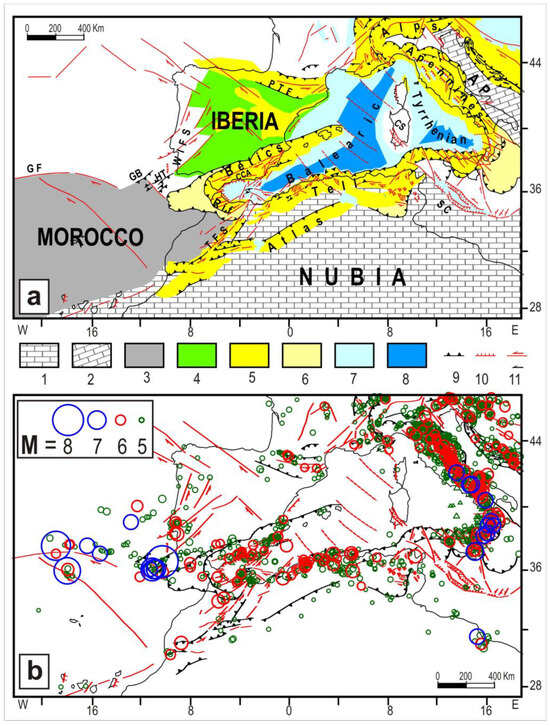
Figure 1.
(a) Tectonic setting of the study area. (1, 2) Nubian and Adriatic continental domains. (3) Morocco block. (4) Iberian block. (5) Main orogenic belts. (6) Recent accretionary zones (7, 8). Zones affected by moderate and intense crustal thinning, respectively. (9, 10, 11) Compressional, extensional, and strike-slip tectonic features. AP = Adriatic plate, CCA = Cadiz–Crevillente–Alicante fault, CS = Corsica–Sardinia block, GF = Gloria fault, GB = Gorringe bank, HT = Horseshoe thrust, PTF = Pyrenean thrust front, SC = Sicily Channel, TFS = Transmoroccan fault system, WIFS = Western Iberian fault system. (b) Main earthquakes that occurred in the study area since 1000 A.D. In green, the events with M < 6; in red, events with 6 ≤ M < 7; and in blue, events with M ≥ 7. Data sources from [9,10,11,12,13,14,15,16,17,18,19,20,21,22,23,24] and research institutions for seismology (IRIS), available at http://ds.iris.edu/ieb/, accessed on 1 November 2024.
In the Eocene, the African plate, encompassing the Adriatic continental promontory and the interposed Ionian Tethys oceanic domain, moved roughly NNE-ward with respect to Eurasia [1,4,6,7]. This plate convergence led to the formation of the Alpine belt at the collisional border with Europe in the early Oligocene (Figure 2A).
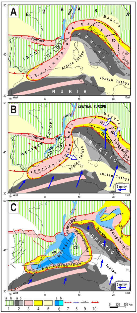
Figure 2.
(A) Initial configuration of the study area in the early Oligocene. Al = Alkapa block, TD = Tisza block, RGS = Rhine Graben system. (B) Early Miocene. The trench-arc-back arc process starts developing in the western Mediterranean region. BP = Balearic promontory, CS = Corsica–Sardinia block, LG = Lion gulf, VG = Valencia gulf. Empty arrows indicate the motions of the Iberian Alpine arc and the rotations of the Alkapa and Tisza blocks, driven by belt-parallel compression. (C) Upper Miocene. The migration of the Iberian Alpine belt and the opening of the Balearic basin ceases. (1) Continental (a) and thinned continental (b) Eurasian domains; (2) continental (a) and thinned continental (b) African/Adriatic domains; (3) Alpine orogenic belts; (4) Oligo-Neogenic accretionay belts, with European and African affinity; (5) old oceanic domains; (6) zones affected by intense (a) or moderate (b) crustal thinning; (7, 8, 9) compressional, extensional, and strike-slip tectonic feature; (10) Outer fronts of the orogenic belts. Blue arrows indicate the kinematic pattern with respect to Europe (scale in the inset).
In the western Mediterranean, large portions of the Alpine Tethys, such as the Betic, Penninic, Valais, and Ligurian oceanic zones (e.g., [25,26,27,28]), were subducted due to the convergence between the Africa/Adriatic plate and the Iberia block, which was moving independently of Eurasia [6,29,30]. Specifically, along the southern Iberian margin, the SE-ward subduction of the above oceanic zone beneath a continental domain (Alkapeca, including the Alboran, Kabylides, Peloritani, and Calabria fragments, [31,32,33]), and the underthrusting process developing after the collision, led to the formation of the Alpine–Iberian metamorphic belt (e.g., [2,4,6] and references therein).
In the Oligocene, the northwestern sector of the continental Nubian domain collided with the southernmost edge of the Iberian Alpine belt. Stressed by belt parallel compression, the belt underwent lateral eastward bending at the expense of the Alpine Tethys oceanic domain in the early Miocene (Figure 2B). Accretionary chains (Apennines and Maghrebides) were built up along the consuming fronts, while extensional processes behind the migrating belt led to the formation of the Balearic basin [2,6,8].
This phase ended when the N-S migrating segment (Alpine–Apennines) collided with the Adriatic continental domain (Middle Miocene) and when the E-W belt segment (Maghrebides) collided with the Nubian continental domain (Middle–Upper Miocene). The suturing of these consuming boundaries halted extension in the Balearic basin and accretion along the Maghrebian and Apennine belts (Figure 2C).
Since then, tectonic activity in the western Mediterranean area has primarily been driven by the collision of northwesternmost Nubia with the interposed Alpine Iberian belt (Betics and Rif) and the Iberia continental block (Figure 3). One notable process is the progressive curvature and westward escape of the Alboran arc at the expense of the North Atlantic domain. This process was guided by transpressional faults in the Betics (e.g., [34,35,36]) and the Rif (e.g., [37,38]). The resulting E-W extension that developed in the wake of that wedge formed the Alboran basin. Another shortening process involves the NE-ward escape of the Iberian block, guided by a system of transpressional faults located onshore and offshore along the western Iberian side (referred to here as WIFS, e.g., [39,40,41,42,43]) and by transpressional faults within the Betics. The convergence of this block with the European domain is evident from the seismotectonic activity along the Pyrenean front (Figure 3a, e.g., [44,45,46,47]).
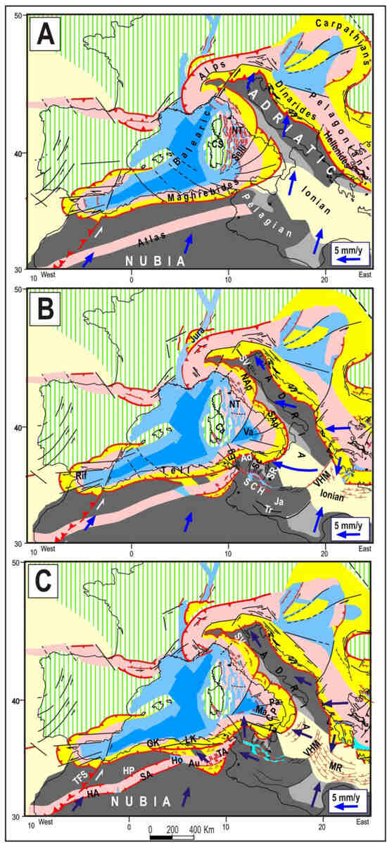
Figure 3.
Neogene–Quaternary evolution of the central and western Mediterranean regions. (A) Late Miocene. NT = Northern Tyrrhenian. (B) Middle–Late Pliocene. Ad = Adventure wedge, Ca = Campidano Graben, Eg = Egadi fault, Ja = Jarrafa fault, NAp = Northern Apennines, SAp = Southern Apennines, Sc = Sciacca fault, SCH = Sicily Channel, SR = Scicli–Ragusa fault, SV = Schio–Vicenza fault, Tr = Tripolitania fault, Va = Vavilov basin, VHM = Victor Hensen–Medina fault. (C) Pleistocene. Au = Aures, CP = Calabria–Peloritani wedge, GK = Greater Kabylia, HA = High Atlas, Ho = Hodna basin, HP = High Plateau, LK = Lesser Kabylia, Ma = Marsili basin, MR = Mediterranean Ridge, Pa = Palinuro fault, SA = Saharan Atlas, TA = Tunisian Atlas, Ta = Taormina fault, TFS = Transmoroccan fault system. Colors, symbols, and other abbreviations as in Figure 2.
The great resistance opposed by the above collision caused a considerable increase in shear stress between the main Nubia plate and its northwesternmost (blocked) edge. In the middle Miocene, this context led to the activation of a major discontinuity, the sinistral Transmoroccan fault ([48,49,50] and references therein), which has allowed the main Nubia plate to move NNE-ward with respect to its northwestern edge, which became part of the Morocco–North Atlantic plate shown in Figure 4 [1,4,6,7].
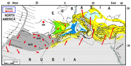
Figure 4.
Proposed plate configuration and long–term kinematics in the Mediterranean region. The red dots (IBE, MOR, and NUB) indicate the Euler poles of the Iberia (green), Morocco (grey), and Nubia plates with respect to a Eurasian reference frame. Red arrows show the motions of the three plates with respect to Eurasia predicted by the respective rotation poles [1]. Al = Alboran wedge. Colors and symbols as in Figure 1.
Around the early Pliocene, the tectonic setting in the central and western Mediterranean underwent a drastic change in response to the collision of the escaping Anatolian–Aegean system with the Adriatic continental promontory, which led to the decoupling of the Adria plate from Nubia through the formation of a major discontinuity in the Ionian domain (Victor Hensen–Medina fault) and the Pelagian domain (Sicily Channel fault system). Once decoupled, the Adria plate underwent a clockwise rotation, inducing strong E-W compression in the Pelagian domain and the northern Nubian margin. The shortening driven by this regime was accommodated by the northward escape of the Adventure wedge, with the consequent displacement/bending of the facing Maghrebian belt (Figure 3b, [2,4,8]). The effects of this process in the central Mediterranean region, with the formation of the Vavilov and Marsili Tyrrhenian basins, are described in previous research [2,4,8]. Stressed by the westward push of the Adriatic Pelagian system, the northern Nubian belts (Atlas and Tell) underwent oroclinal bending, thrusting, and uplift (Figure 3c, [51]).
2. Seismicity Distribution and Short-Term Evolution of Tectonic Processes
It is well known that each major earthquake triggers a perturbation of the strain/stress field in the surrounding zones which propagates with velocities controlled by the rheological properties of the structures involved (e.g., [52] and references therein). This process may increase stress in the surrounding fault zones, depending on the ongoing tectonic processes, reducing the delay time of their next failures. Some tentative qualitative predictions about these possible effects in the various seismic zones of the studied region are reported in the following.
Transmoroccan fault system (TFS). The activation of this discontinuity triggers a sinistral displacement of western Nubia with respect to the Morocco plate, which increases compressional stress in the Tell.
Rif and Betic belts and Western Iberian fault system (WIFS). Major earthquakes along the transpressional faults in the Rif and Betics belts promote the westward escape of the Alboran wedge. Shocks in the Betic faults and in the WIFS promote the NE-ward escape of the Iberian block, increasing stress in the Pyrenean thrust zone. Both the above extrusions may facilitate the NNE-ward displacement of western Nubia.
Tell (Algeria, Tunisia). A shock at one of the transpressional or thrust faults in this belt may trigger a NE-ward acceleration of the involved belt sector, increasing compressional stresses in the adjacent Tell segments and in the Transmoroccan fault system.
To tentatively recognize how the above effects may have influenced the spatiotemporal earthquake distribution within the 1600–2024 time window, we have considered the six time intervals shown in Figure 5. This choice was based on the considerations explained in the following.
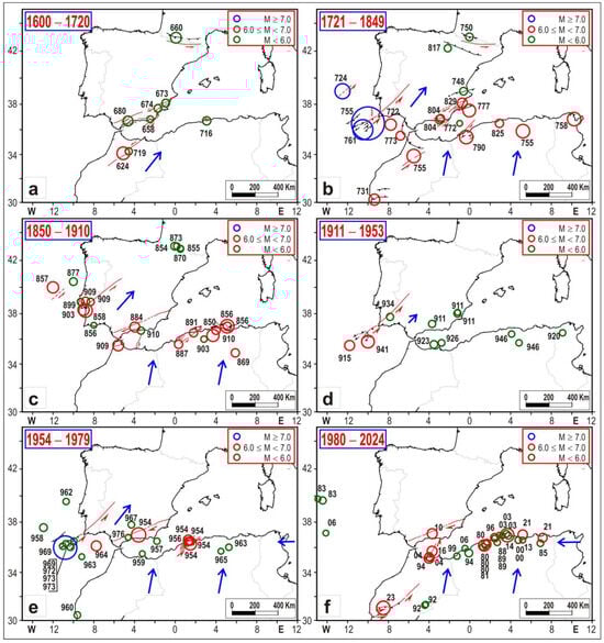
Figure 5.
Spatiotemporal distribution of major earthquakes (M ≥ 5.5) in the 6 time intervals indicated in the pictures and described in Section 2. The numbers close to circles indicate the year. In the 1600–1720 time interval, the blue arrow indicates the possible acceleration of western Nubia, triggered by shock in the Transmoroccan discontinuity and in the Betics. In the 1721–1849 interval, the arrows in northern Nubia indicate the possible acceleration of the Tell, triggered by major earthquakes in this belt and promoted by the NE-ward escape of the Iberian block. This context may have continued in the subsequent interval (1850–1910). In the time interval 1911–1953, da minor escape of the Iberian block can be supposed. In the time interval 1954–1979, the minor escape of the Iberian block may continue, while a displacement of the central part of the Tell may occur. The arrow in Tunisia indicates the possible westward displacement of the Adriatic–Pelagian domain induced by the post-1939 jump of Anatolia. In the last time interval, the intense seismicity in the Tell may have been driven by the coeval westward displacement of the Pelagian domain and the NE-ward displacement of Nubia. Sources of seismicity data as in Figure 1.
Time interval 1600–1720 (Figure 5a). In this relatively long time frame, seismic activity was relatively low in all zones. Magnitude 6 was only reached by a few earthquakes in the TFS (1624, M = 6.7), the Betics (1680, 6.3), the Tell (1716, 6.0), and the Pyrenees (1660, 6.4). No earthquakes with M > 5.5 were reported in the catalogues for the WIFS, Rif, and North Atlantic zones.
Time interval 1721–1849 (Figure 5b). Considering that the Nubia plate moves at an average rate of about 5–10 mm/y with respect to Eurasia, one may expect that during the previous time interval (1600–1720), the advancement of that plate was between 600 and 1200 mm. It is reasonable to suppose that such a displacement caused a strengthening of stress in the collision zones between northwestern Nubia and Iberia. This might explain the marked increase in seismic activity that occurred in the subsequent time interval (Figure 5b). Strong events occurred in the outer front of the Alboran wedge, the Cadiz gulf (1722, 6.5), the TFS (1731,6.4), the Rif (1755, 6.8), the WIFS, and the central and southern Portugal offshore area (1724, 7.0; 1755, 8.5; 1761, 7.5). Then, two major earthquakes hit the Tell (1755, 6.8; 1758, 6.8). After this phase, seismic activity underwent a significant lowering for several decades (until about 1850), only involving three strong shocks, two in the Betics (1777, 6.7, and 1829, 6.3) and one in the Tell (1790, 6.8). The occurrence of some earthquakes in the Pyrenees (1750, 6.1; 1817, 5.8) might be an effect of the displacement of the Iberian block that was promoted by the activations of the Betics and WIFS lateral guides during the first seismic phase of this time interval.
Time interval 1850–1910 (Figure 5c). During this interval, major earthquakes hit the WIFS (1857, 6.5; 1858 6.8; 1877 5.9; 1899, 5.9; 1903, 6.5; 1909, 5.8, 6.0), the Betics (1884, 6.3; 1910, 5.8), the Rif (1909, 6.4), and the Tell (1850, 6.0; 1856, 6.0, 6.8; 1869, 6.0; 1887, 6.0; 1903, 5.6; 1910, 6.6). It is worth noting that in this phase, the major earthquakes in the Tell occurred in belt sectors that had not been hit by the previous events (1716, 1755, 1758, 1790). This could indicate that during this phase, there was a sort of completion of the previous breakings.
Time interval 1911–1953 (Figure 5d). During this interval, seismic activity was relatively low in all zones, with magnitudes mostly lower than 6. Only two events with M > 6 (1915, 6.3; 1941,6.7) occurred in the Atlantic front of the Alboran wedge. One could suppose that this phase represented the beginning of a new long period of moderate seismicity (like the one that occurred in the 1600–1720 time interval), following a phase of intense activity (1721–1910). However, this potential quiescent phase was suddenly interrupted by a considerable increase in seismic activity since 1954.
Time interval 1954–1979 (Figure 5e). During this interval, several shocks occurred in the Transmoroccan fault system (1959, 5.5; 1960, 5.7), in the Atlantic zone lying offshore the Cadiz gulf (1964 6.2; 1969 7.8), and particularly, in the Tell (1954, 6.7, 6.3, 6.0, 6.0; 1956, 6.0; 1963, 5.6; 1965, 5.5). The fact that all these earthquakes followed the 1954 Betics deep shock (M = 6.9 h = 640 km) could suggest some connection between these events. However, the poor understanding of the deep structures beneath this zone does not allow us to identify the tectonic mechanism which may underlie any possible connection. Some authors [53,54] envisage a structural continuity of the slab, while other authors [55,56] suppose a disrupted slab. The fact that the deepest earthquakes (600–650 km) are not associated with significant shallower seismicity at lower depths (except the weak shocks in the first 100 km) would favor the second hypothesis. It remains to be explained why earthquakes occur at such high depths beneath the Betics.
Time interval 1980–2024 (Figure 5f). The Tell was again hit by several strong and moderate earthquakes (1980, 6.5, 5.9, 6.2, 5.7; 1985, 5.7; 1988, 5.6; 1989, 5.5, 5.7; 1994, 5.9; 1996, 5.5; 1999, 5.6; 2000, 5.7; 2003, 6.8, 5.7, 5.7; 2008, 5.5; 2013, 5.5; 2014, 5.5; 2021, 6.2, 6.1). Major shocks also affected the Transmoroccan fault system (1994, 5.9; 2004, 6.3, 5.7; 2016, 6.3; 2023, 6.8). Another deep shock occurred in 2010 under the Betics (M = 6.3, h = 623 km).
It is worth noting that in the last two phases (Figure 5e,f), no earthquakes with M > 6.0 occurred in the WIFS and in the Betics (apart from the 1954 and 2010 deep earthquakes). This seismicity pattern contrasts with what occurred in the previous phases (Figure 5b,c), when the Tell earthquakes were mostly preceded by strong shocks in the WIFS and the Betics–Rif. We are obviously aware that this difference can hardly be defined as anomalous behavior given the low number of cases available. However, there is major evidence which could confirm the peculiarity of the 1954–2024 seismicity pattern, i.e., the fact that 24 major earthquakes (M ≥ 5.5) occurred in the Tell since 1954, while only 12 shocks occurred in the previous (much longer) time frame (1600–1954) (Figure 5a–d). To explain this jump in seismicity, one could can take into account the possibility that it was induced by the post-seismic relaxation triggered by the westward displacement of the Anatolia–Aegean–Adriatic–Pelagian system since 1939 [5,57,58]. In this regard, it is worth noting that the effects of the 1939 Anatolian event reached, in a few years, the Marmara zone [59] located more than 1000 km from the first triggering event (e.g., [57,58]). This migration rate suggests that the effects of stress diffusion may have reached the northern Nubian margin in some decades, promoting the strong earthquakes that hit this zone since 1954 (Figure 5e,f).
Another comment can be devoted to the seismic activity in the North Atlantic that may have promoted the 1960 (M = 5.7) and 2023 (M = 6.8) earthquakes in the TFS (Figure 6). The series of strong shocks that occurred from 1931 to 1969 along the discontinuity running from Azores to Gibraltar (Terceira ridge, Gloria fault, Gorringe bank, and Horseshoe thrust scarp) suggests that during that time interval, the Morocco plate may have undergone a significant counterclockwise rotation (Figure 4). This implies that the easternmost sector of this plate may have undergone a NW-ward motion, alleviating compression at the TFS, where the 1960 (M = 5.7) and 2023 (M = 6.8) earthquakes took place. One could also take into account the possibility that the increase in stress in the TFS was favored by the NE-ward displacement of northern Nubia, triggered by the intense seismicity which occurred in the Tell since 1954 (Figure 5e,f).
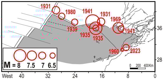
Figure 6.
Major earthquakes that occurred since 1930 along the Azores–Gibraltar discontinuity. These events may have triggered a roughly NW-ward displacement of the easternmost Morocco plate. The consequent decrease in compressional stress in Morocco might have promoted the 1960 (M = 5.7) and 2003 (M = 6.8) shocks along the TFS.
3. Discussion
The redistribution of stresses following a major earthquake is conditioned by the driving forces applied to the study area and by the tectonic processes that accommodate these dynamics. Therefore, a reliable reconstruction of that framework is essential to identify the possible effects of major seismic crises on the spatiotemporal distribution of the main shocks. In this analysis, we have adopted the geodynamic interpretation proposed in previous studies [1,2,3,4,5,6,7,8], since it allows more plausible explanations for the complex deformation pattern in the Mediterranean region. This choice implies significant differences in some major aspects of the geodynamic framework with respect to other popular views.
For example, in our analysis, we assume a SSW-NNE orientation of the Nubia–Eurasia convergence [1,2,3,4,5,6,7,8], while other researchers propose a quite different orientation (SE-NW). Another critical divergence between our geodynamic interpretation and those adopted by other authors lies in the influence of the westward escape of Anatolia on the tectonic activity in the central and western Mediterranean zones. The evidence and arguments supporting our viewpoint are detailed in several publications (e.g., [1,2,3,4,5,6,7,8]), particularly in the book [4]. Naturally, the above distinct dynamic frameworks imply markedly different effects following the post-1939 major Anatolian jump. This work aims to illustrate the results obtainable by analyzing seismicity time patterns based on the geodynamic perspective outlined in Section 2.
A key implication of our perspective involves the generation and the role played by the Transmoroccan fault system. We suppose that major shocks along this fault enable western Nubia to decouple from its northwestern edge (Morocco), alleviating the strong resistance opposed by the Iberian continental block.
Although this work provides only qualitative considerations, one could hope that it will encourage more quantitative evaluations of stress diffusion, using numerical modeling, to examine post-seismic effects in the studied region.
4. Conclusions
Some hypotheses are advanced about a potential link between the spatiotemporal distribution of major earthquakes, since 1600, and the short-term evolution of tectonic processes in the northern Nubian and Iberian zones. Seismic activity in the Transmoroccan, Rif, Betic, WIFS, and Pyrenean fault zones is supposed to accommodate the shortening processes driven by the convergence between northwestern Nubia and Iberia. Seismicity in the Tell is primarily driven by the NNE-ward displacements of northern Nubia and the westward displacements of the Adriatic–Pelagian domain, stressed by the Anatolian–Aegean system. In the time frame considered here, distinct periods can be identified, each characterized by varying spatiotemporal distributions of major earthquakes. During the first phase (1600–1720), seismic activity was relatively low, with most earthquakes having magnitudes below 6. This phase was followed by a relatively long period of intense activity in all zones (1721–1829) and (1850–1910), involving very strong earthquakes in the WIFS. Then, after a phase of low activity (1911–1953), several major earthquakes occurred in the Tell (1954–2024). The last strong earthquake hit the Transmoroccan fault system in 2023.
This distribution of events may provide insights into the potential short-term evolution of tectonic processes. It is supposed that major earthquakes in the WIFS and the Betics lateral guides promote the NE-ward escape of the Iberian block, while major events in the Betics and the Rif facilitate the westward escape of the Alboran wedge. Both these extrusions may facilitate the NNE-ward displacement of northwestern Nubia. Such displacement, potentially amplified by major shocks at the Transmoroccan fault system, may increase compressional stress in the Tell, along with seismic hazard. Seismic activity in the Tell might also be induced by the westward displacement of the Adriatic–Pelagian domain, driven by major advancements of the Anatolian–Aegean system. This hypothesis could explain why seismic activity in the Tell has undergone a considerable increase since 1954, when the most intense effects of the post-1939 jump of Anatolia may have stressed the northern Nubian margin. This interpretation may also be supported by the fact that the above increase in seismic activity was not preceded by significant earthquakes in the Iberian fault systems, in contrast to what happened in previous seismic phases (1721–1910).
The hypothesis that deformation in the Tell is induced by the combined effect of the NNE-ward displacement of Nubia and the westward displacements of the Adriatic–Pelagian domain can explain the right lateral transpressional stress field recognized in that zone by the analysis of neotectonic and seismological evidence, onshore and offshore. Conversely, explaining this strain field as an effect of the Nubia–Eurasia convergence, as often proposed in the literature, appears to be quite problematical.
Considering the insights tentatively achieved by this study, we dare to state some remarks concerning the ongoing stress level in some zones of the study area. For instance, it is worth noting that the last major earthquake in the WIFS occurred about 115–120 years ago (1903, M = 6.5; 1909, M = 6.0). Given that the previous main events in that zone took place in 1724, 1755, 1761, 1857, and 1858, it may be possible that the present delay in major shocks is close to the time interval required to accumulate a critical stress value in that zone.
A similar consideration could be made for the Betics, where the last major shock occurred in 1884 (M = 6.7), about 140 years ago. However, the low number of previous (known) shocks in that zone does not allow a reliable estimate of the average recurrence time for strong events.
The Transmoroccan fault system has been very recently activated by a strong earthquake (2023). This could imply a low seismic hazard for that fault in the next decades, but considering the distribution of major shocks around the Morocco plate (Figure 6), it cannot be neglected the possibility that, in the next decades, another major event may occur in other (more northern) sectors of that fault system.
As concerns the Tell zone, it seems very difficult to propose any hypothesis about the present seismic hazard, since we do not know if the effects of the post-1939 Anatolian westward jump have become negligible. The fact that geodetic observations in the northern Nubian zones indicate a NW-ward motion (e.g., [60]) could imply that such effects are still stressing that belt.
Author Contributions
Conceptualization and methodology E.M. and M.V.; Investigation and data curation E.M., M.V., D.B., C.T., M.B. and V.D.; Writing E.M.; Fund acquisition: E.M., M.B. and V.D. All authors have read and agreed to the published version of the manuscript.
Funding
This research was funded by the Regione Toscana (Italy), Department of Seismic Prevention, grant number: B65F19003190002.
Data Availability Statement
This information was reported by the cited references.
Conflicts of Interest
The authors declare no conflict of interest.
References
- Mantovani, E.; Viti, M.; Babbucci, D.; Albarello, D. Nubia-Eurasia kinematics: An alternative interpretation from Mediterranean and North Atlantic evidence. Ann. Geophys. 2007, 50, 341–366. [Google Scholar] [CrossRef]
- Mantovani, E.; Viti, M.; Babbucci, D.; Tamburelli, C.; Cenni, N. Geodynamics of the Central Western Mediterranean Region: Plausible and Non-Plausible Driving Forces. Mar. Pet. Geol. 2020, 113, 104121. [Google Scholar] [CrossRef]
- Mantovani, E.; Viti, M.; Babbucci, D.; Tamburelli, C.; Hoxha, I.; Piccardi, L. Geodynamics of the South Balkan and Northern Aegean Regions Driven by the Westward Escape of Anatolia. Int. J. Geosci. 2023, 14, 480–504. [Google Scholar] [CrossRef]
- Mantovani, E.; Viti, M.; Babbucci, D.; Tamburelli, C. Neogenic Evolution of the Mediterranean Region: Geodynamics, Tectonics and Seismicity; Springer: Cham, Switzerland, 2024; p. 174. [Google Scholar] [CrossRef]
- Mantovani, E.; Viti, M.; Babbucci, D.; Tamburelli, C.; Baglione, M.; D’Intinosante, V. Ductile Versus Brittle Tectonics in the Anatolian–Aegean–Balkan System. Geosciences 2024, 14, 277. [Google Scholar] [CrossRef]
- Viti, M.; Mantovani, E.; Tamburelli, C.; Babbucci, D. Generation of Trench-Arc-Backarc Systems in the Western Mediterranean Region Driven by Plate Convergence. Boll. Soc. Geol. Ital. 2009, 128, 89–106. [Google Scholar] [CrossRef]
- Viti, M.; Mantovani, E.; Babbucci, D.; Tamburelli, C. Plate Kinematics and Geodynamics in the Central Mediterranean. J. Geodyn. 2011, 51, 190–204. [Google Scholar] [CrossRef]
- Viti, M.; Mantovani, E.; Babbucci, D.; Tamburelli, C.; Caggiati, M.; Riva, A. Basic Role of Extrusion Processes in the Late Cenozoic Evolution of the Western and Central Mediterranean Belts. Geosciences 2021, 11, 499. [Google Scholar] [CrossRef]
- Karnik, V. Seismicity of the European Area, Part I and Part 2; Springer: Dordrecht, The Netherlands, 1971. [Google Scholar]
- Rothé, J.P. Seismicité de l’Atlantique oriental, de la Méditerranée occidentale et de ses bordures. Rev. Géographie Phys. Géologie Dyn. 1971, 13, 419–428. [Google Scholar]
- Roussel, J. Les zones actives et la frequence des seismes en Algerie (1716–1970). Bull. Soc. Hist. Nat. Afr. Nord Alger 1973, 64, 211–227. [Google Scholar]
- Poirier, J.P.; Taher, M.A. Historical seismicity in the near and middle East, north Africa and Spain from Arabic documents (VIIth-XVIIIth century). Bull. Seism. Soc. Am. 1980, 70, 2185–2201. [Google Scholar] [CrossRef]
- Ambraseys, N.N. Material for the investigation of the seismicity of Tripolitania (Libya). Boll. Geof. Teor. Appl. 1984, XXVI, 143–155. [Google Scholar]
- Benouar, D. Materials for the investigation of the seismicity of Algeria and adjacent regions during the twentieth century. Ann. Di Geofis. 1994, XXXVII, 459–860. [Google Scholar] [CrossRef]
- Mezcua, J.; Martinez Solares, J.M. Sismicidad del area Ibero-Moghrebi. Publicacion 203; Instituto Geografico Nacional: Madrid, Spain, 1983; p. 302. [Google Scholar]
- Godey, S.; Bossu, R.; Guilbert, J.; Mazet-Roux, G. The Euro-Mediterranean Bulletin: A comprehensive seismological bulletin at regional scale. Seismol. Res. Lett. 2006, 77, 460–474. [Google Scholar] [CrossRef]
- Pelaez, J.A.; Chourak, M.; Tadili, B.A.; Ait Brahim, L.; Hamdache, M.; Lopez Casado, C.; Martinez Solares, J.M. A Catalog of Main Moroccan Earthquakes from 1045 to 2005. Seismol. Res. Lett. 2007, 78, 614–621. [Google Scholar] [CrossRef]
- Ekström, G.; Nettles, M.; Dziewonski, A.M. The global CMT project 2004–2010: Centroid-moment tensors for 13,017 earthquakes. Phys. Earth Planet. Inter. 2012, 200–201, 1–9. [Google Scholar] [CrossRef]
- Grünthal, G.; Wahlström, R. The European-Mediterranean Earthquake Catalogue (EMEC) for the last millennium. J Seismol. 2012, 16, 535–570. [Google Scholar] [CrossRef]
- Stucchi, M.; Rovida, A.; Capera, A.A.G.; Alexandre, P.; Camelbeeck, T.; Demircioglu, M.B.; Gasperini, P.; Kouskouna, V.; Musson, R.M.W.; Radulian, M.; et al. SHARE European earthquake catalogue (SHEEC) 1000–1899. J. Seismol. 2012, 17, 523–544. [Google Scholar] [CrossRef]
- ISIDe Working Group. Italian Seismological Instrumental and Parametric Database (ISIDe), Version 1.0; Istituto Nazionale di Geofisica e Vulcanologia (INGV): Rome, Italy, 2016. [Google Scholar] [CrossRef]
- Poujol, A.; Ritz, J.-F.; Vernant, P.; Huot, S.; Maate, S.; Tahayt, A. Which fault destroyed Fes city (Morocco) in 1755? A new insight from the Holocene deformations observed along the southern border of Gibraltar arc. Tectonophysics 2017, 712–713, 303–311. [Google Scholar] [CrossRef]
- Suwihli, S.; Paradise, T.R. Creating a Libyan Earthquake Archive: From Classical Times to the Present. Open J. Earthq. Res. 2020, 9, 367–382. [Google Scholar] [CrossRef]
- Rovida, A.; Locati, M.; Camassi, R.; Lolli, B.; Gasperini, P.; Antonucci, A. Italian Parametric Earthquake Catalogue (CPTI15), Version 4.0.; Istituto Nazionale di Geofisica e Vulcanologia (INGV): Rome, Italy, 2022. [Google Scholar] [CrossRef]
- Chalouan, A.; Michard, A. The Alpine Rif belt (Morocco): A case of mountain buinding in a subduction-subduction-transform fault triple junction. Pure Appl. Geophys. 2004, 161, 489–519. [Google Scholar] [CrossRef]
- Schmid, S.M.; Fugenschuh, B.; Schuster, R. Tectonic map and overall architecture of the Alpine orogen. Eclogae Geol. Helv. 2004, 97, 93–118. [Google Scholar] [CrossRef]
- Finetti, I.R.; Boccaletti, M.; Bonini, M.; Del Ben, A.; Pipan, M.; Prizzon, A.; Sani, F. Lithospheric Tectono-Stratigraphic Setting of the Ligurian Sea-Northern Apennines-Adriatic Foreland from Integrated CROP Seismic Data. In CROP PROJECT: Deep Seismic Exploration of the Central Mediterranean and Italy; Finetti, I.R., Ed.; Elsevier: Amsterdam, The Netherlands, 2005; Chapter 8; pp. 119–158. [Google Scholar]
- Handy, M.R.; Ustaszewski, K.; Kissling, E. Reconstructing the Alps–Carpathians–Dinarides as a key to understanding switches in subduction polarity, slab gaps and surface motion. Int. J. Earth Sci. 2015, 104, 1–26. [Google Scholar] [CrossRef]
- Roest, W.R.; Srivastava, S.P. Kinematics of the plate boundaries between Eurasia, Iberia, and Africa in the North Atlantic from the Late Cretaceous to the present. Geology 1991, 19, 613–616. [Google Scholar] [CrossRef]
- Macchiavelli, C.; Vergés, J.; Schettino, A.; Fernàndez, M.; Turco, E.; Casciello, E.; Torne, M.; Pierantoni, P.P.; Tunini, L. A new southern North Atlantic isochron map: Insights into the drift of the Iberian plate since the Late Cretaceous. J. Geophys. Res. Solid Earth 2017, 122, 9603–9626. [Google Scholar] [CrossRef]
- Guerrera, F.; Martin-Martin, M.; Perrone, V.; Tramontana, M. Tectono-sedimentary evolution of the southern branch of the Western Tethys (Maghrebian Flysch basin and Lucanian Ocean): Consequences for Western Mediterranean geodynamics. Terra Nova 2005, 17, 358–367. [Google Scholar] [CrossRef]
- Puga, E. A reappraisal of the Betic Ophiolitic association: The westernmost Relic of the Alpine Tethys ocean. In CROP PROJECT: Deep Seismic Exploration of the Central Mediterranean and Italy; Finetti, I.R., Ed.; Elsevier: Amsterdam, The Netherlands, 2005; Chapter 31; pp. 665–704. [Google Scholar]
- Michard, A.; Negro, F.; Saddiqi, O.; Bouybaouene, L.; Chalouan, A.; Montigny, R.; Goffé, B. Pressure-temperature-time constraints on the Maghrebide mountain building: Evidence from the Rif-Betic transect (Morocco, Spain), Algerian correlations, and geodynamic implications. Comptes Rendus Geosci. 2006, 338, 92–114. [Google Scholar] [CrossRef]
- Gràcia, E.; Pallàs, R.; Soto, J.I.; Comas, M.; Moreno, X.; Msana, E.; Santanach, P.; Diez, S.; Garcia, M.; Danobeitia, J. Active faulting offshore SE Spain (Alboran Sea): Implications for earthquake hazard assessment in the Southern Iberian margin. Earth Planet. Sci. Lett. 2006, 241, 734–749. [Google Scholar] [CrossRef]
- Sanz de Galdeano, C. The Cadiz-Alicante Fault: An important discontinuity in the Betic Cordillera. Rev. Soc. Geológica España 2008, 21, 49–58. [Google Scholar]
- Martínez-Díaz, J.J.; Masana, E.; Ortuño, M. Active tectonics of the Alhama de Murcia fault, Betic Cordillera, Spain. J. Iber. Geol. 2012, 38, 253–270. [Google Scholar] [CrossRef]
- Moratti, G.; Piccardi, L.; Vannucci, G.; Belardinelli, M.E.; Dahmani, M.; Bendkik, A.; Chenakeb, M. The 1755 “Meknes” earthquake (Morocco): Field data and geodynamic implications. J. Geodyn. 2003, 36, 305–322. [Google Scholar] [CrossRef]
- Poujol, A.; Ritz, J.-F.; Tahayt, A.; Vernant, P.; Condomines, M.; Blard, P.-H.; Billant, J.; Vacher, L.; Tibari, B.; Hni, L.; et al. Active tectonics of the Northern Rif (Morocco) from geomorphic and geochronological data. J. Geodyn. 2014, 77, 70–88. [Google Scholar] [CrossRef]
- Cabral, J. An example of intraplate neotectonic activity, Vilarica Basin, northeast Portugal. Tectonics 1989, 8, 285–303. [Google Scholar] [CrossRef]
- Ribeiro, A.; Cabral, J.; Baptista, R.; Matias, L. Stress pattern in Portugal mainland and the adjacent Atlantic region, West Iberia. Tectonics 1996, 15, 641–659. [Google Scholar] [CrossRef]
- Borges, J.F.; Fitas, A.J.S.; Bezzeghoud, M.; Tevescosta, P. Seismotectonics of Portugal and its adjacent Atlantic area. Tectonophysics 2001, 337, 373–387. [Google Scholar] [CrossRef]
- Vilanova, S.P.; Fonseca, J.F.B.D. Seismic hazard impact of the Lower Tagus Valley Fault Zone (SW Iberia). J. Seismol. 2004, 8, 331–345. [Google Scholar] [CrossRef]
- Martín-González, F.; Antón, L.; Insua, J.M.; De Vicente, G.; Martínez-Díaz, J.J.; Muñoz-Martín, A.; Heredia, N.; Olaiz, A. Seismicity and potencially active faults in the Northwest and Central-West Iberian Peninsula. J. Iber. Geol. 2012, 38, 52–69. [Google Scholar] [CrossRef]
- Mauffret, A.; Durand De Grossouvre, B.; Tadeu Dos Reis, A.; Gorini, C.; Nercessian, A. Structural geometry in the Eastern Pyrenees and Western Gulf of Lion (Western Mediterranean). J. Struct. Geol. 2001, 23, 1701–1726. [Google Scholar] [CrossRef]
- Jabaloy, A.; Galindo-Zaldìvar, J.; Gonzàlez-Lodeiro, F. Palaeostress evolution of the Iberian Peninsula (Late Carboniferous to present-day). Tectonophysics 2002, 357, 159–186. [Google Scholar] [CrossRef]
- Alasset, P.J.; Meghraoui, M. Active Faulting in the Western Pyrenees (France): Paleoseismic Evidence for Late Holocene Ruptures. Tectonophysics 2005, 409, 39–54. [Google Scholar] [CrossRef]
- Lacan, P.; Ortuño, M. Active Tectonics of the Pyrenees: A review. J. Iber. Geol. 2012, 38, 9–30. [Google Scholar] [CrossRef]
- Bernini, M.; Boccaletti, M.; Moratti, G.; Papani, G. Structural development of the Taza-Guercin Basin as a constraint for the Middle Atlas Shear Zone tectonic evolution. Mar. Petrol. Geol. 2000, 17, 391–408. [Google Scholar] [CrossRef]
- Gomez, F.; Beauchamp, W.; Barazangi, M. Role of the Atlas mountains (northwest Africa) within the African-Eurasian plate boundary zone. Geology 2000, 28, 775–778. [Google Scholar] [CrossRef]
- Blanco-Montenegro, I.; Montesinos, F.G.; Arnoso, J. Aeromagnetic anomalies reveal the link between magmatism and tectonics during the early formation of the Canary Islands. Sci. Rep. 2018, 8, 42. [Google Scholar] [CrossRef] [PubMed]
- Mantovani, E.; Viti, M.; Babbucci, D.; Tamburelli, C. Plio-Quaternary tectonic activity in the Northern Nubian belts: The main driving forces. Appl. Sci. 2025, 15, 587. [Google Scholar] [CrossRef]
- Freed, A.M. Earthquake triggering by static, dynamic, and postseismic stress transfer. Annu. Rev. Earth Planet. Sci. 2005, 33, 335–367. [Google Scholar] [CrossRef]
- Spakman, W.; Wortel, R. A tomographic view on western Mediterranean geodynamics. In The TRANSMED Atlas. The Mediterranean Region from Crust to Mantle; Springer: Berlin/Heidelberg, Germany, 2004; pp. 31–52. [Google Scholar]
- Bezada, M.J.; Humphreys, E.D.; Toomey, D.R.; Harnafi, M.; Dávila, J.M.; Gallart, J. Evidence for slab rollback in westernmost Mediterranean from improved upper mantle imaging. Earth Planet. Sci. Lett. 2013, 368, 51–60. [Google Scholar] [CrossRef]
- Piromallo, C.; Morelli, A. P wave tomography of the mantle under the Alpine-Mediterranean area. J. Geophys. Res. Solid Earth 2003, 108. [Google Scholar] [CrossRef]
- Palomeras, I.; Thurner, S.; Levander, A.; Liu, K.; Villaseñor, A.; Carbonell, R.; Harnafi, M. Finite-frequency Rayleigh wave tomography of the western Mediterranean: Mapping its lithospheric structure. Geochem. Geophys. Geosyst. 2014, 15, 140–160. [Google Scholar] [CrossRef]
- Barka, A.A. The North Anatolian Fault Zone. Ann. Tectonicae 1992, 6, 164–195. [Google Scholar]
- Barka, A.A. Slip distribution along the North Atlantic fault associated with the large earthquakes of the period 1939 to 1967. Bull. Seismol. Soc. Am. 1996, 86, 1238–1254. [Google Scholar] [CrossRef]
- Lorenzo-Martin, F.; Roth, F.; Wang, R.J. Elastic and inelastic triggering of earthquakes in the North Anatolian Fault zone. Tectonophysics 2006, 424, 3–4, 271–289. [Google Scholar] [CrossRef]
- Bougrine, A.; Yelles-Chaouche, A.K.; Calais, E. Active deformation in Algeria from continuous GPS measurements. Geophys. J. Int. 2019, 217, 572–588. [Google Scholar] [CrossRef]
Disclaimer/Publisher’s Note: The statements, opinions and data contained in all publications are solely those of the individual author(s) and contributor(s) and not of MDPI and/or the editor(s). MDPI and/or the editor(s) disclaim responsibility for any injury to people or property resulting from any ideas, methods, instructions or products referred to in the content. |
© 2025 by the authors. Licensee MDPI, Basel, Switzerland. This article is an open access article distributed under the terms and conditions of the Creative Commons Attribution (CC BY) license (https://creativecommons.org/licenses/by/4.0/).