Abstract
An analysis of different geosites as territories of high geo-biodiverse value located within the Metropolitan District of Quito (DMQ) in Ecuador is performed based on the geoscientific inventory of thirty-six territorial zones and their geological history, cultural, and biological wealth. This is based on years of research and was complemented with the Geosites Assessment Model (GAM) methodology, the application of the criteria of which results in an impartial quantitative evaluation of each of these geosites, resulting in the determination of geographic areas with high tourist, archeological, and social potential. It also establishes a baseline to generate conservation strategies, scientific dissemination, and the determination of priorities in the management of the conservation of the geological heritage of the DMQ in Ecuador. The geological and geomorphological evolution of the DMQ grants this region a variety of sites formed by mainly cretaceous and quaternary volcanic and sedimentary deposits, geological faults, and other remarkable formations or sequences, which, together with the geoarchaeological sites, give a unique geohistorical value to the DMQ. In this context, the protection of each of the regionally important study sites for their scientific, educational, and cultural value in the geological area, as well as their scenic beauty and biodiversity, is essential. All of these attributes will be input to the future sustainable development approaches of the proposed UNESCO-DMQ Global Geopark by academic experts and researchers working in this territory. Additionally, this study also defines the need for the protection of each study area. The results of the evaluation will help to plan the effective management of the geosites based on their strengths and weaknesses and thus promote the Global Geopark. In this context, the value of the geodiversity of the DMQ has been recognized in this research, specifically for each of the geosites proposed as part of the UNESCO Global Geopark; the DMQ project, highlighting this geological and biodiverse heritage, contributes to direct benefits for the community and at an international level.
1. Introduction
1.1. Proposal for a New UNESCO Global Geopark in Quito
Concern for the state and conservation of the environment in the world has led to the implementation of agreements and policies that promote the use of territories within the framework of sustainable development [1,2]. In this context, the United Nations Organization (UNESCO) began the proposal to create or support programs for the preservation of Natural and Cultural Heritage in 1945, Biosphere Reserves in 1971, and later Geoparks [3,4]. Thus, in the 1990s, Germany, Spain, France, and Greece were the first countries in Europe to have territories under the definition of experimental geopark projects [5,6,7,8]. In 2000, the European Network of Geoparks was created, and later, in 2004, the UNESCO legalized the Global Geopark Network, which currently has 213 Geoparks in 48 countries [9]. The United Nations Conference on Environment and Development includes, in its agenda, territories with geological heritage within the International Program of Earth Sciences and UNESCO Geoparks [10]. The UNESCO conceptualizes geoparks as unique geographic areas of high geological, landscape, natural, and cultural heritage value, managed by governments, the community, and inter-institutional alliances to promote the conservation of geo-biodiversity and the fulfillment of sustainable development goals [11]. A UNESCO Global Geopark needs to meet several requirements, including geological features of international importance, living and active landscapes in which science and local communities develop in a mutually beneficial way, the management of the sustainable use of its natural and cultural heritage, women’s empowerment and gender equality, registration and action plans against geological hazards, climate change, science, and research, ancestral knowledge, education of the local and visiting population, and geo-tourism and geo-conservation, as well as safeguarding the geological value of its territory [12,13].
The criteria that a UNESCO Global Geopark must meet are framed in terms of the protection and conservation of unique and unified geographical areas, as sites and landscapes of international geological importance, protection, education, research, and sustainable development, territories with clear border delimitation whose size is adequate to fulfill its functions, as well as sites that possess a geological heritage of international importance endorsed by scientific professionals in the area [14]. Furthermore, the criteria needs to respect education and development in territories that connect natural and cultural heritage, generating awareness in society of the knowledge and understanding of geological processes, geological risks or hazards, climate change, the use of natural resources, and the evolution of life and the empowerment of indigenous peoples, as well as legal aspects, considering the areas with a standardized management system [15]. If this territory projected to be designated as a UNESCO Global Geopark overlaps with another UNESCO designated site, such as a World Heritage Site or a Biosphere Reserve, the request must provide evidence on the added value of this nomination and how, in synergy with the other designations, it will meet the objectives of each case [16]. Regarding local economic development, with the participation of local communities and indigenous nationalities, the criterion establishes the application of a participatory management model that addresses the social and economic needs of local populations, protects the landscape in which they live, and preserves their cultural identity [17]. The management of a UNESCO Global Geopark will be represented by relevant local and regional actors and authorities, so it is mandatory for the Geopark to join the Global Geoparks Network (GGN) [18]. The Geopark must comply with local and national laws regarding the protection of geological heritage [19,20].
Once the geoparks have met the requirements and guidelines established by the UNESCO Council, they are evaluated every four years under operational guidelines that establish that high-geodiversity areas must respond to the need to conserve nature and grant value and relevance to society as areas of geological importance to the history of the Earth [21]. Geological formations and living landscapes are real testimonies of the evolution of our planet [22]. The importance of global geoparks is determined by the fact that these areas hold fundamental and determining information for the conservation of ecosystems, human–landscape relationships, and the sustainable development of our planet [23]. A Global Geopark, as part of the UNESCO Managed Network, is operationally an alliance between the rich geological heritage, natural heritage, and cultural heritage of the region [24]. UNESCO Global Geoparks promote geology, as well as science in general, by contributing more broadly to UNESCO’s mandate covering education, culture, and communication [11].
In the South American region, there are ten UNESCO-approved geoparks; Brazil leads this designation with six, followed by Ecuador, Chile, Peru, and Uruguay with one UNESCO Global Geopark each [25]. Ecuador, situated in the northwestern side of South America, has an area of some 256,370 km2 and a population of more than 17 million inhabitants. It has four well-defined geographical regions, being the coastal lowland, the highlands with several volcanic arcs, the Amazonian lowlands, and the Galapagos archipelago, with each of the regions containing a great variety of ecosystems and cultures [26,27,28]. This relatively tiny country has a megadiverse flora with more than 25,000 plant species and around 2800 vertebrates, representing approximately 12% of the vertebrate species richness on the entire planet [29]. Hereby, although Ecuador is one of the 17 megadiverse countries on the planet, there are, however, deficiencies in the knowledge of Ecuador’s geodiversity, so it is essential to perform research and execute initiatives to protect the existing geological heritage, which includes interesting sites of topics such as structural geology, geomorphology, paleontology, volcanology, and speleology, amongst many others [30,31,32,33]. In addition, Ecuador has several international designations, of which three correspond to sites declared by UNESCO as part of the cultural heritage of humanity, like the City of Quito (declared in 1978), the Historic Center of Santa Ana de los Ríos de Cuenca (1999), and the Qhapaq Ñan Andean Road System (2014) [34,35,36,37,38]. There are also two sites as Natural Heritage of Humanity, being the Galapagos Islands (1978) and the National Park Sangay (1983) [39,40,41]. Furthermore, there are sites designated by UNESCO as Biosphere Reserves, such as Galapagos (declared in 1984), Wetlands of International Importance (2014), Andean Chocó of Pichincha (2018), and the first UNESCO Global Geopark in Ecuador in the province of Imbabura (2019) [42,43,44,45].
Due to the evident natural, cultural, and geodiversity wealth in Ecuador, there are currently several initiatives for local sustainable development, education, and tourism related to geological factors in which the designation of territories as geoparks is relevant to the governmental management of the country, such as the Tungurahua Volcano Aspiring UNESCO Global Geopark, Zaruma Portovelo, Santa Elena Peninsula Geopark Project Experience, and Napo Sumaco Aspiring UNESCO Geopark, among others. Thus, since 2019, the Ecuadorian Geoparks Committee (CEG) was formed to comply with the UNESCO Geoparks Guidelines, with the aim of promoting the management of territories with high potential for the conservation of their geodiversity [46,47,48,49,50].
Based on the aforementioned context, the current study aims predominantly to propose a new potential Ecuadorian geopark within the Metropolitan District of Quito (DMQ) due to the uniqueness of its many and variable geosites. Hereby, we reviewed, identified, and evaluated many known sites with significant geological wealth and high geodiversity in the DMQ and its areas of influence that meet the criteria to be named a UNESCO Global Geopark. The given inventory of many remarkable geosites and geomorphologies of great diversity will certainly allow for the corresponding authorities and commissions to perceive a better understanding and knowledge of a unique zone and may succeed in declaring this extraordinary area a potential geopark within the UNESCO Global Geopark Network.
1.2. Geodynamic, Geological, and Geomorphological Setting of Ecuador and the DMQ
Situated in the northwestern edge of South America, Ecuador is a bio- and geodiverse country with a high amount of interesting geosites of international, regional, and local scale [42,44,47,51,52,53]. Together with the Galapagos Islands, its extension reaches some 283,561 km2. The continental part of Ecuador borders with Colombia and Peru, while its oceanic area limits with Costa Rica. Ecuador’s geomorphology comprises seven distinctive zones, being the coastal lowlands and the western and eastern highlands, while the Interandean Valley lies between these mountain ranges, the subandean zone, the eastern Amazonian lowlands, and the Galapagos archipelago, some 1000 km distant to the mainland [54,55].
The actual geodynamic constellation of Ecuador and its surroundings is based on the conjunction of a variety of oceanic and continental plates [56,57,58]. Hereby, the Pacific, Cocos, and Nazca oceanic plates diverge from each other, while the Nazca plate is subducting below the Caribbean (North Andean Sliver) and South American continental plates [59,60,61]. Both continental plates are limited by the Guayaquil-Caracas Mega shear, a transcurrent plate boundary [62,63,64]. Based on the given subduction, a high amount of different types of some 250 volcanoes are present in the highlands, the Interandean valley, the subandean zone of Ecuador, while the volcanoes of the Galapagos resulted from the local hot-spot activity [65,66,67,68].
The continental area of Ecuador is geologically a young country which may be divided into four main zones, being the coastal plain or lowland, the uplifted Andean range (western and eastern Cordillera), which are a magmatic arc and the internal hinterland segment of the fold-thrust belt, with its Interandean valley, followed by the external frontal segment of the fold-thrust belt represented by the Subandean Zone, and, finally, the Amazonian foreland basin [69,70,71]. The basement, which is composed of some Precambrian and mainly Paleozoic metamorphic rocks, are rarely present and almost exclusively in the Amazon basin and Subandean Zone [72,73,74]. Most exposed rock formations belong to Jurassic and Cretaceous marine deposits and igneous rocks in the coastal and Amazonian areas [75,76,77]. In the late Cretaceous period, most of Ecuador was covered with marine sediments and volcanic deposits. Later, in the Tertiary period, again volcanics, together with the marine shelf as well as continental sediments, filled the existing basins, including the initial stages of the Interandean valley [78]. Finally, within the Quaternary and up to modern times, strong volcanic activity coincided with tectonic uplift forming the Andean mountain ranges, while in the Amazon and coastal forearc regions prevailed molassic sediments, and in the latter also prevailed marine terraces [79]. Most strong tectonic activities and corresponding geological faults, as well as modern volcanoes, are aligned NNE–SSW, perpendicular to the subduction zone [80,81,82,83].
The study area is the Metropolitan District of Quito (DMQ), which is situated within the Interandean valley comprising also of parts of the Western Cordillera and its eastern foothill area (Figure 1). The DMQ consists of 32 urban and 33 rural parishes extending some 4217.95 km2 and ranging in elevation from 444 to 4787 (average 2620) meters above sea level (Figure 2). Geologically, at the extension of the DMQ appear, in its northwestern area, Cretaceous formations such as Macuchi, Silante, Yunguilla, and the 13 Ma old batholith Apuela-Nanegal, which is mainly granodioritic in composition [84,85,86,87,88,89,90].
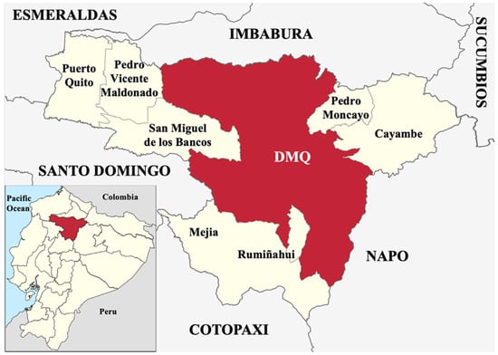
Figure 1.
Inlet: Ecuador and its provinces, standing out the location of the Province of Pichincha. Main frame: The provinces surrounding the province of Pichincha (in capital letters) and the further parishes of Pichincha besides the Metropolitan District of Quito (DMQ), our study area, appearing in red color.
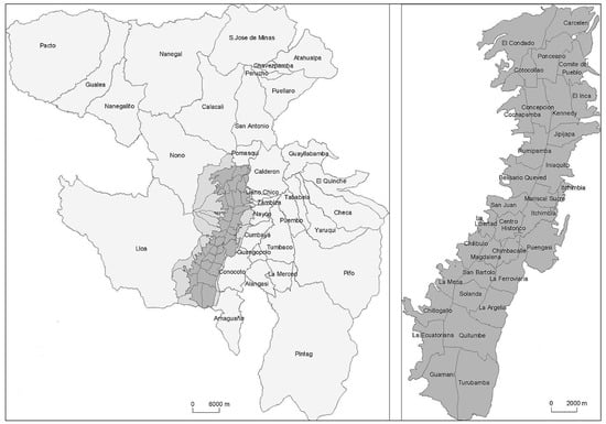
Figure 2.
The DMQ with its 32 urban (right) and 33 rural (left) parishes.
However, most of the DMQ consists of quaternary volcanic deposits (pumice, tuffs, lahars, lava flows, and debris avalanches) of formations such as Rio Pisque, San Miguel, and Chiche and different extinct, dormant, or active stratovolcanoes, calderas, and domes, besides some minor appearances of lagunar, glacial, alluvial, and colluvial deposits. Additionally, there are a variety of geological faults which crosscut the city and vast areas of unstable terrains which are prone to landslides [91,92,93,94,95,96] (Figure 3).
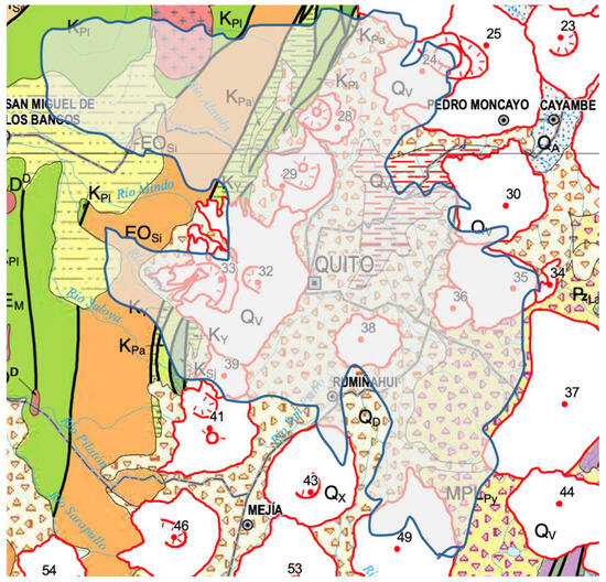
Figure 3.
Geologic map of the DMQ and its surroundings. The shown geological units are Pilatón Group (KPI), Pallatanga Unit (KPa), Yunguilla Formation (KY), San Juan ophiolites) (KSj), Silante Formation (EOSi), Volcanosedimentary facies (QV), Primary and reworked pyroclasts (QD), Stratovolcanes and domes (QX), Pisayambo volcanics (MPLPy). Numbering corresponds to volcanoes and their edifices such as Pululahua (28), Casitagua (29), Rucu Pichincha (32), Guagua Pichincha (33), Fuya-Fuya (24), Mojanda (25), Cusín (23), Pambamarca (30), Cerro Puntas (35), Izambi (34), Coturco (36), Ilaló (38), Chacana (37), Carcacha (39), Atacazo-Niñahuilca (41), Pasochoa (43), Corazón (46), Sincholagua (49), Almas Santas (54), and Antisana (44). Based on the geologic map of Ecuador 1: 1,000,000.
In the beginning of 2020, shortly before the COVID-19 pandemic, the administration of the DMQ invited the principal author of the current study to lead a diverse group of scientists, and several of the personnel of the DMQ, to evaluate the possibility of converting the DMQ to a geopark. The first meetings gave rise to a list of 15 potential geosites, including volcanoes, outlook points, or trails which may be qualified for a preliminary inventory of a site of geoheritage potential. This list has been mentioned in a previous study [44], and gave rise, in 2023, to start a more complete list, which includes a starting variety of various Ecuadorian provinces, leading to a guide of interesting geosites of the provinces Carchi, Imbabura, and Pichincha, of which latter includes some eight geosites of the DMQ [97]. Finally, the current study contains a more detailed approach to the interesting geosites of the DMQ, leading to a list of some 36 remarkable geosites within the extensions of the DMQ.
2. Materials and Methods
Within the methodological context, Brilha, IELIG (Spanish Inventory of Sites of Geological Interest), and GAM methodologies were analyzed in order to understand which best fits the study of geosites, and a review of both positive and negative aspects was realized [98,99,100,101,102,103,104,105]. Therefore, to identify which of the three existing methodologies (Brilha, IELIG, and GAM) best fits the study of geosites, the advantages and limitations of each model in the field of geological tourism were compared.
Thus, the methodology proposed by Brilha [98] focuses on the evaluation of the scientific value of geosites using the application of objective criteria such as representativeness, rarity, integrity, and scientific knowledge, standing out for its focus on the identification, valuation, and conservation of geosites from an academic perspective, although it also incorporates elements that allow for evaluations of their geotourism potential.
For its part, the methodology of the Spanish Inventory of Sites of Geological Interest (IELIG) seeks to catalog sites of geological interest using a systematic analysis that includes geological, biological, and geotourism aspects [100]. This method proposes an assessment that integrates scientific, educational, and tourism criteria, although the latter focus mainly on subjective values, which determine the motivation for the visit. It also analyzes heritage criteria, which acquire significant relevance and weighting within the model.
In this regard, Berrezueta and coworkers [44] highlight the usefulness of this methodology, especially for regional planning, as it facilitates the integration of geosites into routes and geoparks as tourism products. However, when adapting this methodology, it synthesizes it into ten criteria mainly aimed at measuring the geological importance of the site, essentially referring to the inventory of geological heritage or geoheritage, meaning one of the outstanding techniques in this analysis, but leaving aside aspects related to tourism promotion, since it does not incorporate enough criteria specific to this area.
Within this comparative analysis, it is identified that they employ a qualitative and semi-quantitative evaluation methodology based on specific criteria to assess the geotourism potential of geosites using geodiversity analysis. However, this proposal does not follow a standardized framework like those of GAM, Brilha, or IELIG, but, rather, they develops their own matrix composed of nine comprehensive criteria adapted to the territorial context and based on their experience in geoconservation and geotourism. These variables are structured as a global assessment proposal on the feasibility of developing geotourism activities, without a detailed analysis of each specific site. The nine criteria considered are content, values, current and potential use, limitations, conservation, observation conditions, possible negative impacts, and the proposal.
In contrast, Rybár [101] presents a specific methodological proposal aimed at evaluating geosites with the aim of identifying their potential for geopark creation using a detailed list of criteria. This model uses ten criteria, assigning a maximum of eight points to each, allowing for a quantitative assessment of primary geological properties, uniqueness of the object, accessibility, scientific, and professional publications, observation (research) conditions, security criteria, the availability of information, visual value, the value of the services provided, and location in the tourist area. However, he conceptualizes that the analysis of geotourism potential cannot be determined with certainty due to the ambiguity of the concept of tourism, considering that it is not conceived as a fully structured science.
For its part, the Geosites Assessment Model (GAM) methodology [103] offers a multidimensional assessment which examines scientific and educational values as fundamental inputs for the development of tourism activities, in addition to considering the visual limit of the landscape over time, with the purpose of avoiding its alteration [41]. Its holistic approach facilitates the design of sustainable geological tourism products by including criteria such as visual attractiveness, accessibility, human participation, and landscape conservation [104]. In this sense, they incorporate an additional criterion to the traditional scheme, being the cultural one, adapted to the characteristics and conditions of the territory.
Therefore, to establish a comprehensive assessment that allows for the construction of a solid basis for decision-making, it is essential to have research that promotes both the responsible exploration and valuation of natural resources and methodologies that facilitate their sustainable management. In this sense, the promotion of each geosite can and should be leveraged from the perspective of sustainable tourism, integrating scientific, tourism, and social dimensions.
Finally, the study developed by [104] validates the GAM as an ideal methodology, ensuring the adequate assessment of each site, also highlighting the tourism aspects as significant components. Thus, this approach includes specific evaluation and diagnostic processes, placing special emphasis on defining the tourism potential of resources by incorporating values and criteria appropriately adapted to the context of each research project. Consequently, the GAM is used in the development of this research due to its characteristics that adapt to the environment [103].
Using the geological heritage assessment matrix, both primary and additional values are considered, as the former allow for measuring the geological qualities of the site, identifying and characterizing them, while the latter are linked to tourism activities, expanding the analysis beyond the mere categorization of the resource by including dimensions such as infrastructure and tourism facilities. In this way, it is established that the geological element represents the primary function to be evaluated, and the tourism aspects act as complementary elements, necessary to determine whether each area analyzed has tourism potential. In summary, the following table (Table 1) lists a detailed comparison of the most widely used methodologies for geosite evaluation focused on geological tourism, such as Brilha, IELIG, and GAM. It should be noted that the GAM methodology is the one that best suits both the environment and the needs of the research topic.

Table 1.
Comparative evaluation list of Brilha, IELIG, and GAM methodologies.
Using the geological heritage valuation matrix, we consider aspects cataloged as main values and additional values, and, for the first time, we will measure the geological qualities of the site, identifying and characterizing them, while for the second case, it is possible to define them using their associated tourist activity, even though we goes beyond determining the resource category, including dimensions that guarantee tourist development, such as infrastructure and tourist plant. Therefore, interpreting these qualities, we can establish that the geological element fulfills the main function to be evaluated, and tourists are complementary to detail if each area studied represents a potential to perform tourism.
Nonetheless, with the purpose of reducing the subjective factor in the valuation matrix, the present study uses the help of numerical data that certify the level of objectivity as well as allowing for accurate and more effective comparisons to be made of each of the geosites identified. The methodology proposes the valuation of two criteria that measure both the quality of the site as well as defining its potential use within the tourist quality of the geosite. These major criterions are the core and the additional values. Each major criterion includes different categories that facilitate the analysis, determined in the following way:
- 1.
- Criterion: Core values—VP;
- 1.1.
- Category: Scientific and educational values—VSE;
- 1.2.
- Category: Scenic/esthetic values—VSA;
- 1.3.
- Category: Protection values—VPr;
- 2.
- Criterion: Additional values—VA;
- 2.1.
- Category: Functional values—VFn;
- 2.2.
- Category: Tourist values—VTr.
Therefore, each category aggregates several sub-indicators, totaling 27 sub-indicators corresponding to main values and additional values. Each one of them is valued under a scale that goes from 0 for the minimum weighting and 1 for the maximum. The procedure is developed in this context, and with this information, based on [104], the equation for determining the site’s relevance and potential use is defined by the sum of all sub-indicators, as follows:
where VP stands for the Heritage Value, which represents the sum of the values associated with a geosite’s heritage; SV stands for the Scientific Educational Value, which measures the relevance of a site for research and education; VSA stands for the Academic Scientific Value, which assesses the importance of the site to the scientific community; VPr stands for the Protection Value, which reflects the need for conservation and the measures applied to protect the site; VA stands for the Additional Value, which considers additional elements that complement the heritage assessment; VFn stands for the Functional Value, which measures the accessibility and facilities the site offers to visitors; and VTr stands for the Tourism Value, which reflects the site’s potential as a tourist attraction.
GAM = VP(VSE + VSA + VPr) + VA(VFn + VTr)VP (VSE + VSA + VPr) + VA (VFn + VTr).
GAM = VP (VSE + VSA + VPr) + VA (VFn + VTr)
GAM = VP (4 ptos. + 4 ptos. +4 ptos.) + VA (6 pts. + 9 pts.)
GAM = VP (12 pts.) + VA (15 pts.)
GAM = 27 maximum points to reach at each geosite.
Subsequently, the main values and additional values are contrasted within a matrix of X and Y; this contraposition presents results which are based on the technique of reducing variables. To visualize within the matrix, the form of grouping summarizes three basic categories that define levels, being the upper, lower, and averages of each geosite. Hereby, the X axis is divided into four units, while the core values include twelve sub-indicators, and for the Y axis, it is divided into five units, while additional values include fifteen sub-indicators. Finally, we determined that the matrix includes nine very well-marked zones, of which, each of the thirty-six geosites will be located based on the rating received for each category. The results presented in the obtained matrix expose the graph in relation to both the core and additional values, exposing the quantified data of each geosite. With this, it is feasible to determine the importance and significance of each one of them, which subsequently are located within a coordinate in the matrix.
3. Results
An inventory of different sites of cultural, touristic, or geological interest may be based on the diversity of each case. Therefore, we determined to divide the encountered geosites of the DMQ into ten different groups, which may even overlap. For example, within a volcanic complex, there may be geoheritage sites as well as interesting geological trails. In this respect, we considered the following interesting sites: (1) volcanoes, (2) geological hazards, (3) geoarchaeological sites, (4) geobotanical sites, (5) mining areas, (6) geoheritage sites, (7) geomorphological sites or landscapes, (8) trails of geological interest, and (9) paleontological and (10) speleological sites.
Based on a variety of visible criteria and those applied in the used methodology, we obtained a list of 36 interesting or extraordinary remarkable geosites within the DMQ or that are close to the DMQ by having a direct influence on the DMQ area (Table 2). These includes ten volcanoes or volcanic complexes with many more volcanic edifices, four geological hazards, thirteen geoarchaeological sites, one geobotanical site, one mining area, two geoheritage sites, three geomorphological sites or landscapes, and two trails of geological interest, while paleontological and speleological sites will be mentioned, but have been excluded for reasons that will be explained later (Figure 4).
Table 2.
Chosen geosites (GS) within the DMQ.
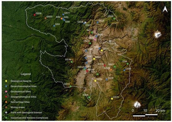
Figure 4.
Distribution of the 36 evaluated geosites within the DMQ.
3.1. Volcanoes and Volcanic Complexes
There is evidently no city in the world that has so many active volcanoes on its surrounding as Quito in Ecuador [106]. The closest volcanoes are Atacazo, Niñahuilca, Carcacha, Pichincha Volcanic Complex (Cinto, Rucu, Guagua, Toaza, Cristal), Casitagua, Pululahua caldera and dome complex, Panecillo, Cotopaxi, Pambamarca, Puntas, Coturco, Cayambe, Antisana volcanic complex, Corazón, Ilalo, Pasochochoa, and Rumiñahui, while further volcanoes may be able to cover the DMQ with volcanic ash, such as Reventador, Cuicocha, and Quilotoa, among several others. There are also many uncounted monogenetic cones, especially volcanic domes, within the DMQ, belonging to the aforementioned volcanic edifices of the volcanic front, the Interandean Valley, and the main arc [66,106,107].
Inside and in very close vicinity of the DMQ, there are a variety of interesting active volcanoes, such as the Pululahua caldera and dome complex (geosite 1: GS1) in the NW side of the DMQ, just slightly north of the equatorial line and its touristic center [108]. At least 16 predominantly andesitic-to-dacitic domes have been identified, belonging to four different units (Units I–IV) [109]. Hereby, Unit III is responsible for the formation of a 3–4 km wide elliptic-shaped caldera-like depression (2.6–2.3 ka) which is open to the west, while the three younger inner-caldera domes, belonging to Unit IV, were formed during the volcano’s most recent activity, which occurred some 2.24 ka ago [109,110,111]. In addition to esthetic outlook points of the volcanic landscape and the high variety of botanic highlights, there are also archeological remains, while hospitality is given by restaurants, hotels, hostels, and camping opportunities in the surrounding areas and inside the caldera. There are many worthwhile visiting spots such as the inner domes for climbers, the “Jacuzzi of the Incas”, which is a small pond with permanent fumarolic activity in form of CO2 ascending gas bubbles, and many trails and horse riding opportunities, among others [112,113,114]. The entire complex was declared a national park in 1966 and later a geobotanical reserve in 1978 (Figure 5H,I).
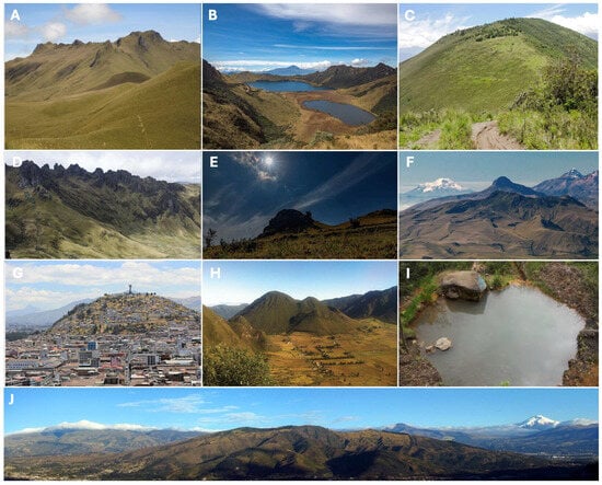
Figure 5.
Volcanoes and volcanic complexes of the DMQ, such as Pasochoa ((A); credit Cal240Sr), Mojanda ((B); credit Patricio Loza Trujillo), Casitagua ((C); credit Ecuventure), Puntas ((D); credit Angie Drake), Cotourcu ((E); credit Quito Informa), Atacazo and Niñahuilca ((F); credit Municipality of Mejia), Panecillo (G), Pululahua caldera and inner domes (H), jacuzzi of the Incas in Pululahua (I) and Ilalo ((J); credit Fernando Ron).
Just a few hundred meters south of the Pululahua volcanic complex, and touching the equatorial line with its highly eroded northern flanks, appears the extinct Casitagua volcano (GS23). The Casitagua Volcano, being some 880–780 ka of age, whose name means “evil mountain that stands still”, has a volcanic caldera that opens to the northwest and has a diameter of approximately 2.5–3.0 km [115]. A volcanic dome rises inside the caldera, where some lava flows have also been identified. Herein is situated the Tagshima archeological site where the first deep performed excavations encountered vestiges of the formative period (1500–500 B.C.) [116,117]. Among the findings are compacted floors, hearths, and post holes, as well as polished stone artifacts, pottery decorated with incisions, and remains of megafauna (felines) [118] (Figure 5C).
The Uravía River, which runs through the valley of the same name, is the natural boundary between the parishes of Checa and El Quinche and originates in the wetlands of the Cerro Puntas volcano (GS9), located about five kilometers from the town of Checa, south of the Pambamarca volcano in the eastern foothills of the Andean Mountain range. The 4452 m high 1.1 Ma old Cerro Puntas is an extinct volcano, being made up of about 50 peaks that give it a peculiar shape, similar to the giant jaw of a moor wolf, the faithful guardian of this natural reserve [115]. Its shape is that of a large horseshoe, with two long chains of rocky peaks that, seen from afar, look like the teeth of a saw, hence its name, “Cerro Puntas”, the hill of spikes. In the center of the horseshoe is the caldera open to the southwest. Cerro Puntas has been characterized as a residual volcano at the transition to the skeleton stage [54]. The volcano, which is predominantly composed of breccias and lavas surrounded by carved glacial valleys, is located on the edge of the Cayambe Coca National Park, from where there is a spectacular view of the city of Quito and its surrounding valleys. In the Uravía Valley, obsidian, pumice, and Cangahua are present, as well as fossilized bones of a mastodon [119] (Figure 5D).
Just a few km southwest of Cerro Puntas is the also extinct, almost 2 Ma old volcano Cerro Cotourco (GS21) [115]. Cotourco is a great place to hike or ride horses. This hill, which some say has a lion’s head, offers a magnificent 360-degree view. The view from this area is strategic, so much so that it was one of the four observation points in pre-Incan times. The word Cotourco comes from “coto”, which means neck, and “urco”, which is the hill. It is located at about 3400 m and is visited by hundreds of people due to its easy access. This is where it is also possible to enjoy camping, cabins, and sport fishing (Figure 5E).
The Atacazo–Ninahuilca-Carcacha Volcanic Complex (GS14), is situated above the Cretaceous Pallatanga Terrane, Yunguilla Formation, and some of the Silante Formation on the southwestern side of the DMQ [120,121,122]. These three different main edifices include Pleistocene stratovolcanoes, which have been later cut by a caldera, open to the southwest. During several stages of the formation of these volcanoes, a variety of dome generations appeared, of which the most prominent are Arenal I and II, Cuscungo, La Viudita, and Gallo Cantana, besides some younger intra-depression domes [123]. Plinian activity has been occurring, of which the results are enormous pumice deposits and pyroclastic-density currents encountered in the SW part of the DMQ and the main highway towards the coast. The youngest activities gave rise to the Niñahuilca Chico lava domes within the summit caldera at 700–300 B.C. [123,124] (Figure 5F).
The 1.2 Ma old extinct and highly eroded Ilalo stratovolcano (GS17) stands out in the flat platform of the Valle de los Chillos, in the southernmost area of the DMQ, within the Interandean Valley [106,115]. The stratovolcano is composed mainly of agglomerated lavas and pyroclastic-density currents [125]. Its surface is highly forested and predominantly covered by Cangahua [126]. In its surroundings appear several younger cryptodomes, which are the reason and origin of various thermal springs on its foothills and hereby also allow for a high geothermal energy potential and fog water collection [127,128]. The Ilalo volcano is crosscut by a prominent NE–SW-striking geological fault and has a very characteristic, prominent collapsed sector open to the west. On its foothills appear strong deposits of many previous lahar flows of the Cotopaxi volcano [120,129,130]. There are ten bigger thermal springs sites visited by a high amount of mainly local tourists, of which the most frequented within the DMQ is the Balneario Cununyacu (Figure 5J).
On the southernmost edge of the DMQ is situated the 0.45 Ma old extinct Pasochoa volcano (GS18), which hosts one of the last remnants of a cloud forest in the Interandean Valley [131,132]. The Pasochoa volcano is aligned with the Ilalo volcano to its north and the Rumiñahui volcano to its south, having similar geochemical compositions and structures [133,134]. Therefore, its eroded western flank is collapsed, forming a horseshoe-shaped amphitheater. The volcano is part of the Pasochoa Wildlife Refuge and a protected forest [135,136] (Figure 5A).
On the northern edge of the DMQ, within the Interandean Valley is situated the 0.6 Ma old Mojanda volcano (GS36), which forms part of the Mojanda-Fuya Fuya-Cushnirumi volcanic complex [115,137,138,139]. The Mojanda volcano is composed of two different edifices, of which the older one formed a stratovolcano (Lower Mojanda), which was later topped by the younger one (Upper Mojanda) [137]. The later collapsed and formed a now water-filled caldera, which is some 3 km wide. Almost contemporaneous was the evolution of the Fuya-Fuya volcano and its Panecillo and Colangal summit domes to the west of Mojanda, as well as the Cushnirumi volcano, situated NW of Mojanda [139]. The Mojanda volcano hosts three protected areas (Reserve Paso Blanco, the Protectional forest of the river Cambugan, and the Protection forests Ili and Quitsaya), being home to 51 species of mammals and many other animals [140] (Figure 5B).
A big part of the western mountain flank of the city of Quito occupies the Pichincha Volcanic Complex (PVC), which is composed of five successive volcanoes, of which the first four are extinct reaching ages from 1.1 Ma to 4 ka (GS16) [141,142]. The El Cinto basal edifice (from 1.1 to 0.9 Ma) is followed by the Rucu Pichincha stratovolcano (from 850 to 150 ka), Guagua Pichincha stratocone (from 60 to 11 ka), Toaza volcanic dome complex (from 11 to 4 ka) within the collapsed avalanche amphitheater of Guagua Pichincha, and, finally, the presently active Cristal volcanic dome complex (from 3700 years ago to the present day) within the Toaza caldera [141,142,143]. Within this most recent eruptive period, volcanic ash falls have been responsible for great impacts on the Valdivia culture and settlements in the coastal area of Ecuador some 3500 years ago [144].
The Cristal volcanic dome complex gave rise to the repeated growth and collapse of volcanic domes, which occurred in the period from 1998 to 2001, of which four prominent eruptions took place (between 5 and 7 October, 26 November, and 10 December 1999). Although continuous monitoring is given, all of those four major eruptions took place within the yellow alert status. The most remarkable eruption occurred on the morning of 7 October 1999, when, in the presence of a clear sky, an almost 15 km high mushroom-shaped eruptive column appeared as a result of a vulcanian to sub-plinian explosion [145]. Currently, there are active fumaroles inside the Cristal volcanic dome complex and various thermal springs, also of touristic use, such as those of Lloa (Figure 6A,B).
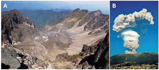
Figure 6.
Crystal volcano and dome complex (A) and the eruption of 7 October 1999 (B) on the foreground the DMQ.
The most prominent and inclusive elevation of the city of Quito is an almost perfect rounded hill, represented by a volcanic dome (GS13) within the historic center named El Panecillo (The Roll). Geologically, it is associated with the basal unit of the Pichincha volcanic complex, having an age of some 1100–850 ka [142]. Above the hill stands a 41 m high statue of the “Virgin of the Panecillo”, also known as the “Virgin of Quito”. This remarkable site not only stands out morphologically of the platform of the city, but it also served as a menhir of aboriginal settlements and has had, on its surface, two temples in the primitive city Quitu-Cara, the one on the top dedicated to the sun and another one further below dedicated to the moon and stars [146]. The Panecillo has served as a geometric center which symmetrically divides the territory, having a lagoon on either side, being both biaxial and rotational. This symmetry imposed by the volcanic dome Panecillo has been understood as a sacred perfection created by Pachamama at the origin of the universe [147]. The DMQ has started to be built in the surrounding of the Panecillo; therefore, also, the very first map of Ecuador’s capital has the hill in its center [148,149] (Figure 5G).
3.2. Geological Hazards
On the highway between the villages of Zambiza and Nayon, right on the eastern side of the city of Quito, appears an outcrop with a remarkable contrast of faulted pyroclastic deposits of ashes and pumices (GS24). One fault exhibits a displacement of up to 6 m. Due to the discovery and presentation of this faults at this geosite in 2010, it has been recognized that the city of Quito has undergone at least one earthquake, with a magnitude between 8 and 9, prior the conquest by the Spaniards. Therefore, based on this evaluation, the two most expensive and representative mega-constructions of the DMQ, the new airport and the metro, have been constructed to resist future earthquakes withstanding magnitudes of up to 9 (airport) and 9.2 (metro) (Figure 7C).
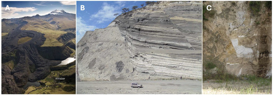
Figure 7.
Antisanilla lava flow of 1760 A.D. ((A); credit Jorge Anhalzer). Volcanic debris avalanche of Collas (B), Zambiza’s geological fault (C).
The almost 6000 m high Cotopaxi volcano, situated some 60 km south of Quito, between the Provinces of Pichincha and Cotopaxi, is the most feared volcano of the Ecuadorians by far [150,151]. Its activity has been detailed, documented, and witnessed by many, as recent hydrothermal activity in 2015 and 2022/23 have even led to deaths due to false alerts [152,153]. The most impacting volcanic hazard of this majestic volcano are far-reaching lahars, some of which transited in past the DMQ and are able to be observed on various sites from its southern border until its northwestern end through the rivers Pita, Santa Clara, San Pedro, and Guayallabamba. The geosite we propose to watch past the destruction of this volcanic hazard is on river Pita, in the sector of Bethania, on the crossing of the oil pipeline, close to the highway E35 (GS33). The concerns of future lahar emplacements is part of the everyday preventive culture of the people on the eastern, southern, and northern sides of the volcano [154,155].
An impressive exposed, very voluminous lava flow of historic times is situated within the southeastern edge of the DMQ within the Parish of Pintag (GS15) [156]. The 10 km long lava flow named Antisanilla was emplaced in 1760 AD, while shortly later, in 1773 AD, another lava flow appeared on its eastern side, extending to some 15 km [157,158,159]. Both erupted from fissures and are astonishing monogenetic lava flows, which most likely belong to the glacial peaked extinct Antisana volcanic complex of the Province of Napo [160]. Since the last few decades, the andesites, which conformed the lava flow, are mined for construction purposes (Figure 7A).
A massive debris avalanche appears along the northern access of the new airport of Quito through the 11.7 km long Collas highway (GS31) which was inaugurated in 2014 [161]. These sometimes extremely mixed mega-clasts of this avalanche belong the Pleistocene San Miguel formation and have been exposed due to the new road cuts from the highway towards Guayllabamba in the northern zone of the city, down to the river Guayllabamba, and then up to the platform Tababela of the new airport [162]. Unfortunately, currently, the sidewalls and former outcrops of the pyroclastic sediments are mostly covered with reinforced concrete. Nonetheless, where the outcrops stay uncovered are nice examples of a previous catastrophic event, as represented by enormous volcanic debris and avalanches of giant proportions [163] (Figure 7B).
3.3. Geoarchaeological Sites
Tulipe (GS3) is known for its rock-built architecture and for being where the Yumbo and Inca people settled (Table 3). It is in the northwest of the DMQ, where there is also a site museum. Evidence from the Paleoindian, Formative, Regional, Integration, and colonial periods is there, showing the use of rocks to build its architecture and the knowledge of which type of rock to use [164,165] (Figure 8F,G).
Table 3.
Historic timeline overview of Ecuador.
Qhapaq Ñan (GS2) is the most known path associated with the Incas that runs from the extreme south of Colombia to northwest Argentina [166]. This route was built with a sophisticated technique that consisted of a cobblestone floor and the construction of bridges over rivers and streams. In northern Ecuador, the walls were made of Cangahua blocks [167]. Within the DMQ, the Qhapac Ñan passes over the Guayllabamba valley to the Historic Center. This site is characterized by the use of Cangahua to build the walls of the path. This geoarchaeological site and trail is part of UNESCO’s World Heritage List [168] (Figure 8D,E).
Located in the downhill of Pichincha volcano, Rumipamba (GS7) has evidence from the late formative, Regional, and Integrative periods, as well as the cultures of Yumbo, Quitu, and Inca [169,170,171]. Evidence of villages and houses built of mud and thatched roofs, stone walls, and graves are not too deep. The location of the archeological evidence gives us an idea that the people knew where to build their houses, considering the geology of the hill (Figure 9B).
La Florida (GS8) is very well known for graves approximately 15 m deep with important funerary offerings that include decorative ceramic objects made of gold and copper and spondylus princeps covering the bodies of the people [172]. It is located in the northeast of Quito and is a site museum (Figure 9C,D).

Figure 8.
Views of Rumicucho site, defensive and administrative sites close to the Inca occupation close to “La Mitad del Mundo” (A,B). A general view of the Portalanza site, adjacent of the Pululahua crater (C). Views of the Qhapac Ñan route in the Guayllabamba valley ((D,E); credit [167]). Tulipe site, northwest of the DMQ region, which is the most representative site of the Yumbo culture (F,G). Finally, the Palmitopamba Pucará, which represents the most western Inca structure of the DMQ ((H); credit [173]).

The Rancho Bajo site (GS35) is known as a cemetery in the urban sector of Quito, northwest of the city (Dyrdahl, 2022) [173,174]. Many individuals were surrounded by Cangahua blocks of many sizes. Also, there is evidence of tephra from the Guagua Pichincha (3300 BP), Pululahua (2400 BP), and Guagua Pichincha (1000 BP) [116], on top of the cemetery, as well as evidence of obsidian and lithic material (Figure 9E).
El Inga (GS30) represents the most prominent evidence of Paleoindian hunter-gatherers [175]. Located on the Ilalo slopes on the northwest of the DMQ, these people lived in caves as well as outdoor places, and to survive, they hunted and recollected plants. There are findings of spearheads, chippers, and bifacial knives, amongst many others [176]. These objects were made from obsidian and basalt, which one is able to encounter in Quiscatola and Mullimica (GS29) [177].
On the northwestern area of the DMQ, in the valley of Nieblí, there is the Portalanza (GS28) geoarchaeological site [178]. Portalanza is a Pucara connected by a Culuncu, which is a road. The pre-existing hill was modified to generate five or six terraces [179]. Today, this hill is covered by vegetation, but beneath that layer, there are remains of walls of rock (Figure 8C).
Located on the north-central side of the DMQ, Perucho (GS25) is where the Caranqui and later the Inca people lived [180]. In the area of Perucho, there are still structures like Pucaras, mounds, or tolas, and tephra from excavations on the site [181] (Figure 9A).
Pucara de Palmitopamba (GS11) is situated on the northwestern area of the DMQ, near Tulipe [173]. The Pucara of Palmitopamba is a fortress built by the Yumbos, where, at the top of the hill, there is a terrace system [182]. Later, it was occupied by the Incas and finally reoccupied by the Yumbos [183]. Also, there are artificial terraces, retaining walls and ceramics from Yumbo and Inca culture (Figure 8H).
The Piedra de Yumba (GS5) is located on the road Nanegal-Palmitopamba, before the bridge of the Alambí River. The Yumba Rock is on the riverbank of Alambí. There are many local legends known by the people [184]. They named it “indiecita encantada”, meaning enchanted little Indian girl, because the rock will not let them pass through in the middle of the night.
The Piedra de Oronzona (GS6) is located before the town of Nanegal. The Oronzona rock is the union of giant rocks that appear like a cavern. On the inside, there is a small waterfall, approximately four meters tall. As well, there are local legends around the giant rock [185].
Rumicucho (GS32) is a monumental geoarchaeological site found in the parish of San Antonio de Pichincha, just a few kilometers from the iconic Mitad del Mundo Monument. Research conducted at the site has revealed that it was inhabited during the Inca expansion in the 15th century, coinciding with the arrival of the Tawantinsuyo in the northern Andes. It is believed that Rumicucho was part of a strategic network of fortresses and administrative centers built by the Incas to integrate and control newly conquered territories [186]. The site features a series of platforms and stone walls, suggesting that it may have served a military and defensive purpose, enabling the monitoring and control of routes linking the Northern Highlands, the Amazon, and the Ecuadorian coast. Furthermore, its strategic position on a hill offered a commanding view of the expansive Quito valley, allowing for control over access to the region’s natural resources. However, Rumicucho’s role extended beyond military use, and it also likely served as a ceremonial and administrative center, as its orientation and design suggest possible astronomical alignments, related to the observation of solstices and other celestial events. Thus, Rumicucho would have been an important social convergence point where rituals were performed to reinforce the Inca worldview and legitimize their power over local populations. This site is significant in understanding how the Incas consolidated their control over the region, integrating both military strategies and cultural practices to secure their dominance over the indigenous communities of what is now Ecuador [187] (Figure 8A,B).

Figure 9.
A profile of the Perucho site, demonstrating the volcanic tephra and the raised fields in the area (A). A picture of the Rumipamba site indicating the lahar and human occupation (B). Images of the site La Florida, representing elaborate tombs and local leaders with spondylus poncho (C,D). Finally, human burials at the site of Rancho Bajo ((E); credit [188]).

In the parish of Pifo, there is the Mullimica valley located on the moor between 3800 and 4400 m above sea level, 17 km from the Inga site. Within this site, there are countless caves, including the Colibrí cave, which is hypothesized to have been one of the first places of refuge for prehistoric man, considering that the cave in its entirety is made of obsidian [189]. Therefore, Mullimica (GS29) is both a spectacular natural obsidian outcrop and an important archeological site in Ecuador, where the early inhabitants, dating back to the Paleoindian Period, exploited this valuable volcanic rock. Obsidian was essential to produce cutting tools and spear and arrow points, crucial for securing protein sources and ensuring the survival of these early populations [190,191]. Archeological research in the area has revealed that rock shelters within the obsidian flow were temporarily occupied by montane forest groups, who utilized this raw material throughout much of the pre-Hispanic era in Ecuador. During the Paleoindian and Archaic periods, the use of Mullimica obsidian appears to have been primarily confined to sites in the nearby northern Sierra. However, from the Formative Period onward, up until the arrival of the Incas, obsidian from this source was distributed more widely, reaching sites in the coastal region, Amazonia, and even the northern border region with Colombia [176,189,192,193,194].
3.4. Geobotanical Sites
Due to a prominent volcanic dome collapse of the Pululahua caldera and dome complex, with a directed blast of the La Marca dome some 9.5 ka ago, a very prominent basal ash flow deposit covered a vast area of the San Antonio village along the equatorial line [108]. There, along the Monjas river (GS34), some very prominent charcoal layers appear, having thicknesses of a few mm up to about 65 cm. These charcoal deposits have been preserved due to this catastrophic event, although they went through a contact–metamorphic impact and are holding valuable information of the past sedimentary environment of a lagoonal facies of calm waters, exhibiting from dozens to hundreds of species of plants, algae, diatoms, fungi, pollen, spores, bacteria, biomass in general, and other kinds of microfossils of some animal remains [195] (Figure 10).
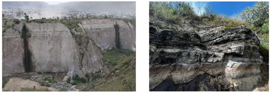
Figure 10.
Enormous Basal ash flow in clear colors with some black charcoal layers of the Pululahua caldera and dome complex in the San Antonio village within the Monjas river (left) and prominent charcoal layers of the same site (right).
3.5. Mining Areas
Mining is a double-edged sword in Ecuador. It is necessary for the economic development of the country, but far too much wrong-handled mining by locals and even by large mining companies have had a bitter impact on Ecuadorians, and even more so on environmentalists [196,197]. The DMQ is also very concerned to protect areas, especially around watersheds and where biodiversity is an issue [198]. Therefore, such areas are protected by law due to the Municipal Protection based on the Conservation and Sustainable Use as Areas of Municipal Protection as well as Conservation and Sustainable Use (APM-ACUS). This resulted in the DMQ being declared to be Natural Heritage Reserves of the State [199]. Nonetheless, there are two different zones where some mining occurs in the DMQ, being the Interandean Valley, where most of the mining is for rock or rocky material, mainly for construction purposes, and the NW area of the DMQ within the Cretaceous deposits. Hereby, a representative exploration mine for gold free of any contamination, as extraction and purification of the ore is performed elsewhere, is encountered in Pacto (GS20). The goldmine run by a family hosts clear visible gold pebbles in the quartzite of an epithermal deposit of the Chontal metasediments of the Macuchi formation close to a piece of granodiorite of similar composition and origin to the Apuela-Nanegal batholith [84,87,88].
3.6. Geoheritage Sites
The cascade of Piragua (GS4) is one of the easily accessible waterfalls which is able to be visited by many tourists just shortly outside Nanegal on the NW edge of the DMQ. The almost 35 m high waterfall represents a geological fault within the Apuela-Nanegal batholith, which itself is composed predominantly by granodiorites, but may vary towards tonalites, granites, quartzdiorites, and diorites [84,87,88]. The massif intrudes deposits of the Macuchi and partly Silante formations [200]. Currently, this popular site is used for relaxation activities, hiking, and even bathing near the waterfall. Its infrastructure also includes a viewing point and a small interpretation center (Figure 11).
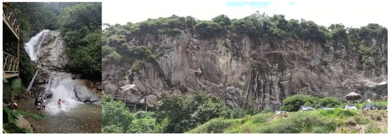
Figure 11.
The cascade of Piragua (left) and Sigsipamba (right; credit Escala Ecuador).
On the eastern side of the DMQ, close to the village of Pifo and along the highway E28, is the geosite Sigsipamba (GS12), where some ignimbrites stand out in horst structure hills. These rocks belong to the 0.85 Ma old El Tablón flow unit, which was previously known as Guambi volcanics [201,202]. These rocky outcrops, which appear as vertically joined walls, are spectacular sites for rock climbing, and are part of a 4 km3 consistent flow [203]. The flow is composed of perlitized obsidian, which itself is stratified with hydrated material [176]. The obsidian obtained from this El Tablón flow unit has been used historically for pre-Columbian chipped stone assemblages (Figure 11).
3.7. Geomorphological Sites or Landscapes
The system of geological faults of Quito crosses the city from north to south [96,204,205]. This inverse fault system, due to compressional forces, is situated east of the western Cordillera, within the Interandean valley, which was later filled with sequences of volcanoclastic, volcanic–sedimentary, fluvial–lacustrine, and alluvial deposits of the Guayllabamba, Chiche, Machángara, and Cangahua formations [95]. This is visible due to the 60 km long altered landscape, which starts at la loma (hill) de Puengasí (GS22) until the Catequilla’s elevation. These structural features, which are the product of a multitude of past earthquakes, are easy to observe along the many outlook points along the Simon Bolivar highway. These elevated geomorphological characteristics 400–500 m above the rest of the Interandean valley are Bellavista with Catequilla, as well as Carcelen with El Inca, then further south La Bota, El Batán, and Ilumbisí, followed by Puengasí, later San Miguel, ending at El Tablón [97].
Mashpi is part of the Rainforest Biodiversity Reserve of the Ecuadorian Chocó in the northwestern end of the DMQ (GS26) [206,207,208]. There, within the rivers San Vicente, Malimpias, and, later, the river Mashpi, appear volcanic metasediments of the Chontal sequence, which is part of the Cretaceous Macuchi formation [209,210]. This sequence is nicely exposed along the almost flat, walkable rivers, and consists of shales, quartzites, schists, and brecciated conglomerates. Due to erosion, the given appearances of this sequence, in some parts of the rivers, are exposed like man-made paintings of red-yellow alternative stripes, as the sequence is strongly inclined (Figure 12).
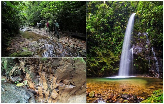
Figure 12.
Impressions of Mashpi (credit Metropolitan Tours).
In the eastern part of the DMQ, within the Interandean valley, there are three different close-by bridges which transect the river Chiche (GS10), which itself crosses Tumbaco with the suburb of Chiche [211,212]. There, a marvelous panoramic view is given to a profile of the 120 m thick almost horizontally deposited volcano sediment sequence of the upper Pleistocene Chichi formation [213]. The formation consists of well-stratified conglomerates, coarse-grained sandstones, and volcanic ash layers. The contact to the Cangahua formation is transitional. Due to the accessibility of walking paths, the entire profile may be visited and studied in detail from top to bottom (Figure 13).
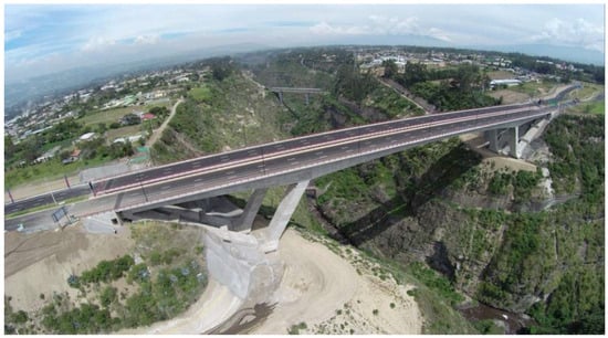
Figure 13.
Aerial panoramic view of the most modern Chiche bridge with the prominent strata of the Pleistocene Chichi formation (credit Chiche Dron).
3.8. Trails with Geological Interest
Just north of Calacali, in the NW area of the DMQ, along the rivers Blanco and Guayllabamba appears the type locality of the Upper Cretaceous Yunguilla formation (GS27) [86,210,214]. The best observed track is about 4 km, being limited by the formation Silante on its western side and faulted by the Macuchi formation on its eastern end. The Yunguilla formation is usually covered by Cangahua and prominent lahar deposits, originating from the Cotopaxi volcano [215]. The up to 2 km thick formation is characterized by folded black siltstones, limestones, gray-to-brown sandstones, black silicified clays, and occasionally sandwiched lavas. The Yunguilla village and area is known for its communal type of tourism [216].
North of the city of Quito, leaving the village of Guayllabamba, heading to the river Pisque, and, from there, following up either to the outlook site Mirador Pisque or towards the village of Jerusalem and the Aguapark, one encounters, along the Northern Panamerican highway, one of the most extraordinary accumulations of slumping folds and faults worldwide (GS19). They are the result of the movement of semi-consolidated volcaniclastic sediments of the Lower Pleistocene San Miguel formation within a previously existing lagoon [162].
Typically, such structures are the result of either seismic or gravitational forces, which, once they have been triggered, lead to the spectacular roadcut-outcrops along the described ways [217,218]. Hereby, in a marvelous didactic opportunity, all types of folds and faults are visible of all sorts of angles, allowing for spectators to admire geological art that is difficult to observe elsewhere (Figure 14).
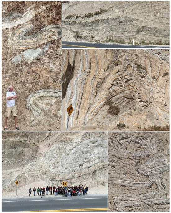
Figure 14.
Road cuts of the Guayllabamba trail with a variety of slumping folds and faults.
3.9. Paleontology
Fossils have been found in a variety of places within the DMQ, but there is not a single visitable site which could be qualified as an outstanding geosite or outcrop. Many deposits of skeletons have been encountered within the city in popular and now habituated areas (La Ronda, campus of Central University, Historical Center, Metropolitan park, La Floresta, El Trébol, Villa Flora, La Carolina park, El Batán, Iñaquito, Calderón, Miraflores, Conocoto, San Rafael, Tumbaco, Guayllabamba, Llano Chico, Calderón, Tababela, Tanda, Malchinguí y San Antonio de Pichincha, etc.), which include typical megafauna of the final part of the Quaternary, within the Upper Pleistocene deposits of the Cangahua [219,220]. These may include xenarthros (Oreomylodon wegneri, Megatheriidae sp. indet.), deer (Odocoileus virginianus), rodents (Sigmodon alstoni, Caviidae sp. indet.), giant camels (Palaeolama weddelli), carnivores (Panthera onca andina, Lycalopex culpaeus), mastodons (Notiomastodon platensis, Cuvieronius hyodon), horses (Equus (Amerhippus) andium), lagomorphs (Sylvilagus brasiliensis andinus), ichnofossil (Beetle nest fossil; Coprinisphaera kitu), and insects (Phanaeus violete), among several others [221,222,223,224,225,226,227,228,229,230,231,232,233,234].
3.10. Speleology
Ecuador has a vast area of speleological mapping and research, but mainly in the Galapagos and the Amazonian basin [51,235,236]. There are several smaller caves of only weak geological interest within the DMQ, like those at Mullimica. The only cave of real geological and speleological interest, which has even archeological value in the DMQ vicinity, is named Cerro Campana. Unfortunately, the site is just outside the NE side of the DMQ area, close to the Cayambe volcano.
4. Discussion
Berrezueta and coworkers [44], within their study, adapt the three previously mentioned methods and synthesizes them into criteria to measure the geological importance of a site within Ecuador. Such insightful analysis serves as a key reference for the development of this study, thanks to the depth of their contextualization. Hereby, their comprehensive approach allows for an understanding of the dynamics studied and provides a solid foundation for developing new research, enriching the theoretical and methodological framework employed. This study, inspired by Berrezueta, seeks to broaden understanding and generate significant contributions to the field of study addressed. It essentially refers to the geopark part, geological route, geological heritage inventory, or geoheritage, leaving aside aspects that allow for the promotion of the site because it does not include many criteria for the tourist part. Later, the GAM methodology designed based on new criteria (content, values, current use, potential use, limitations, conservation, observation conditions, possible negative impacts of the visitor, and the proposal) gives little relevance to the tourist part [237]. Furthermore, there is the use of a list within the methodological context to evaluate each geosite, and, in this sense, the creation of the geopark [238]. This uses different criteria and gives each one a maximum of eight points for its evaluation, being the primary geological properties, unicity of the object, accessibility of the object, existing scientific and professional publications, conditions for observation (investigation), criteria for security, availability of information about the object, the visual value of the object, the value of services provided, and objects in the tourist area. Conceptualizing that the analysis for geotouristic resources cannot be determined with certainty, it possibly has tourist potential due to the ambiguity of this term, given that tourism is not conceived as a science. Additionally, in a further study, it has been considered an additional regular criterion that is cultural for the characteristics and conditions of the territory.
In this context, to determine an integral evaluation that allows for the construction of a solid basis that facilitates any decision-making process, it is essential to rely on studies that allow for the exploration of natural resources as well as methodologies that facilitate their responsible exploration. Promotion of each geosite can be used from the perspective of the destination as sustainable tourism.
In this sense, in a study based on the GAM, which is determined as suitable, is based on several methodologies, resulting in guaranteeing the value of each site, characterizing tourist aspects as significant [104]. This is how it includes processes for evaluation and diagnosis, and gives great importance to the definition of the potential of tourist resources, involving values and criteria that are correctly adapted to what is estimated for the present investigation (Table 4).
Table 4.
Evaluation of all geosites.
Based on the given evaluation, as illustrated in Figure 15, and in the particular case of Z21, the main values that are assessed are within the average, while there is work to be performed regarding the additional values, since they are low. While, in the case of Z12, we identify low core values, the additional values are average. Z31 includes all of those geosites with the highest weighting within the core values, but, unfortunately, the additional values are very low. Z22 includes sites that are average for the main and additional values criteria. The Z32 zone projects high core values and combines them with medium additional values. Z23, on the other hand, represents average main values, but is accompanied by high additional values. Finally, Z33 includes all of those geosites with high core values and which are opportunely complemented with high additional values. This zone is recognized as the most ideal one. To facilitate the analysis, it is prudent to review the following table, which lists the global values achieved at each site, identifying the coordinate in which they are located, which allows for them to be ranked according to the zoning realized.
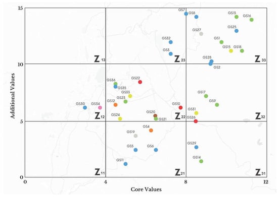
Figure 15.
Layout of the geosites according to the valuation and typology of the 36 chosen geosites of the DMQ.
It is important to note that, according to Figure 14, in situ observations determined that the sites located in quadrant Z33 are the most outstanding in terms of geological, tourist, and promotional visitation. However, this does not detract from the other sites located in other quadrants, which also have valuable attributes.
The development of this research is based on the vast experience of our expert geologists and their education and dissemination in various areas or disciplines of geology, who, for more than thirty years, consolidated an inventory and the valuation of places of interest related to geoscience in Ecuador and the world. This historical and updated information complies with the assessment of the geological heritage of the DMQ in Ecuador and proposes the dissemination of these high-value geosites, as well as their protection, and, in the short term, promotes the sustainable development of the community. The selection of the thirty-six geosites and their technical–scientific descriptions and valorization as geological heritage, also includes the photographic record of each study area, highlighting the scenic and geobiodiversity and geoarchaeological richness in this territory. As a complement to the aforementioned factors, the categorization of the geosites using the GAM methodology, several indicators are categorized on the importance of promoting sites of tourist interest, especially those geosites of singular scenic beauty, cultural richness, and which have the services, security conditions, and infrastructure, among others, and which promote the sustainable socio-economic area and strengthen the proposal to create the UNESCO Global Geopark of the DMQ.
It is also worth mentioning that the GAM method was applied in geoparks such as Villuercas-Ibores-Jara (Spain) and Araripe (Brazil) to prioritize and evaluate geosites based on their scientific, educational, and tourism value. Based on these studies, conservation and geotourism were prioritized, highlighting the need for sustainable strategies to protect geological heritage without affecting its use in tourism. Likewise, in the Tuscan-Emilian Apennines (Italy) and M’Goun (Morocco) geoparks, this methodology demonstrated that sites with high geological value also have tourism potential. The results underscore the importance of balancing conservation with tourism and implementing protection measures to prevent the degradation of natural heritage.
Finally, the present study allows for an insight of how even a capital city of a country is able to contain remarkable geosites, which, once they have been characterized and evaluated for their geological interest, may form a list interesting enough to be proposed within the city’s district as a geopark, like an open-air museum, similar to elsewhere [239,240]. The proposal of the 36 encountered, characterized, and evaluated geosites within the DMQ area may allow not only for the enhanced development of rural and urban educational tourism, but also for the recognition of the importance of such sites and their subsequent preservation [241,242,243]. This may even lead to upgrading these sites to national and international geoheritage sites. Although lately, while geoparks are established based on many side attractions like cultural, environmental, and even biological aspects, the present study follows the original idea to identify predominantly geological and geomorphological sites with a strong impact on geoarchaeology [244,245,246].
5. Conclusions
The proposal of the Metropolitan District of Quito as a UNESCO Global Geopark (DMQ-GPU) is based on the fulfillment of the UNESCO requirements for this type of international designation which consider, among others, the unparalleled geological wealth of 36 remarkable geosites located in this district, bio-geographic zones of relevant geodiverse, natural, and cultural value, community management, socio-administration, tourism promotion, and an enormous potential in the economic, educational, and sustainable development field of the DMQ as a geodiverse heritage of great value for Ecuador and the world.
The study and characterization of the different areas of geological importance of the DMQ performed in the current research strengthen the recognition of the geotourism potential as a dynamic agent of the economy of the region based on the sustainable use of natural resources, specifically the protection of the 36 geosites rich in geobiodiversity, as well as the archeological and ethnological assets of the DMQ.
The proposal for a new Ecuadorian geopark based on the presentation of 36 geosites of high geological, biodiverse, cultural, and social value within the DMQ demonstrates that it is far superior to other geoparks around the world. Qualitatively and quantitatively, this comprehensive geological heritage complies with the guidelines for this designation, and also promotes government management, enhancing the proposal for the recognition of the DMQ as an aspiring UNESCO Global Geopark, as well as the management of the sustainable use of its natural resources, the good management and protection of its geodiverse areas, and educational and scientific research activities disseminating and raising awareness about its natural, scenic, and historical value to the world.
The combination of geologically and archeologically significant sites strengthens the proposal for the creation of a geopark. This initiative integrates spaces of geological importance, which reflect the natural history of the DMQ, with the transformations brought about by human populations over time. It highlights the unique synergy between the natural environment and the constructed landscape, illustrating how natural forces and human activity have shaped the region’s identity.
This blend of natural and cultural elements creates a unique framework that underscores the value of these landscapes as the result of both natural processes and human interactions. The proposal for the geopark emphasizes this distinctiveness, showcasing how geological formations, archeological sites, and human cultural practices come together to form a living, evolving record of the relationship between people and their environment.
Author Contributions
Conceptualization: T.T., G.T.P.-B. and P.M.E.-C.; Methodology: P.M.E.-C., G.F.A.-C., M.F.C.-M. and D.F.C.-B.; Software: M.V.-M.; Validation: T.T. and W.S.-Á.; Formal analysis: T.T., P.M.E.-C. and M.F.C.-M.; Investigation: T.T., G.T.P.-B., P.M.E.-C., G.F.A.-C., F.D.-E., M.V.-M., M.F.C.-M., D.F.C.-B., C.F. and I.S.-G.; Resources: T.T., F.D.-E. and C.F.; Data Curation: P.M.E.-C.; Writing—Original Draft Preparation: T.T., G.T.P.-B., P.M.E.-C., F.D.-E. and M.V.-M.; Writing—Review and Editing: T.T.; Visualization: M.V.-M.; Supervision: T.T.; Project Administration: T.T.; Funding Acquisition: T.T., W.S.-Á. and I.S.-G. All authors have read and agreed to the published version of the manuscript.
Funding
This research did not receive any external funding.
Institutional Review Board Statement
Not applicable because this article does not contain any studies with human or animal subjects.
Conflicts of Interest
The authors declare that they have no competing interests.
References
- Dernbach, J.C. Sustainable development as a framework for national governance. Case West. Res. Law Rev. 1998, 49, 1. [Google Scholar]
- Boer, B. Institutionalising ecologically sustainable development: The roles of national, state, and local governments in translating grand strategy into action. Willamette L. Rev. 1995, 31, 307. [Google Scholar]
- Boylan, P.J. Geological site designation under the 1972 UNESCO World Heritage Convention. Geol. Soc. Lond. Spec. Publ. 2008, 300, 279–304. [Google Scholar]
- Henriques, M.H.; Brilha, J. UNESCO Global Geoparks: A strategy towards global understanding and sustainability. Epis. J. Int. Geosci. 2017, 40, 349–355. [Google Scholar]
- Fassoulas, C.; Staridas, S.; Perakis, V.; Mavrokosta, C. Revealing the geoheritage of Eastern Crete, through the development of Sitia Geopark, Crete, Greece. Bull. Geol. Soc. Greece 2013, 47, 1004–1016. [Google Scholar]
- Blersch, M.; Keller, J.; Matusch, T.; Dannwolf, L.; Siegmund, A. The Network of UNESCO Sites: Changes and Patterns Visualised with Cartograms. In Creative Ways to Apply Historical GIS: Promoting Research and Teaching About Europe; Springer International Publishing: Cham, Switzerland, 2023; pp. 181–195. [Google Scholar]
- Hose, T.A.; Vasiljevic, D.A. Protecting and Promoting the Geoheritage of South-Eastern Europe. Geoherit. Geotourism Eur. Perspect. 2016, 173–194. [Google Scholar] [CrossRef]
- Golfinopoulos, V.; Papadopoulou, P.; Koumoutsou, E.; Zouros, N.; Fassoulas, C.; Zelilidis, A.; Iliopoulos, G. Quantitative Assessment of the Geosites of Chelmos-Vouraikos UNESCO Global Geopark (Greece). Geosciences 2022, 12, 63. [Google Scholar] [CrossRef]
- Zouros, N. The European Geoparks Network-Geological heritage protection and local development. Epis. J. Int. Geosci. 2004, 27, 165–171. [Google Scholar]
- McKeever, P.J.; Zouros, N.C.; Patzak, M. The UNESCO global network of national geoparks. In The George Wright Forum; George Wright Society: Hancock, MI, USA, 2010; Volume 27, pp. 14–18. [Google Scholar]
- Patzak, C.M.; Eder, W. “UNESCO GEOPARK” A new programme-a new UNESCO label. Geol. Balc. 1998, 28, 33–36. [Google Scholar]
- UNESCO. Operational Guidelines for UNESCO Global Geoparks. Available online: https://unesdoc.unesco.org/ark:/48223/pf0000391354 (accessed on 12 December 2024).
- Papadopoulou, E.E.; Papakonstantinou, A.; Vasilakos, C.; Zouros, N.; Tataris, G.; Proestakis, S.; Soulakellis, N. Scale issues for geoheritage 3D mapping: The case of Lesvos Geopark, Greece. Int. J. Geoherit. Parks 2022, 10, 435–446. [Google Scholar]
- Becerra-Ramírez, R.; Gosálvez, R.U.; Escobar, E.; González, E.; Serrano-Patón, M.; Guevara, D. Characterization and geotourist resources of the Campo de Calatrava Volcanic Region (Ciudad Real, Castilla-La Mancha, Spain) to develop a UNESCO global geopark project. Geosciences 2020, 10, 441. [Google Scholar] [CrossRef]
- Leitão, L.; Badman, T. Opportunities for integration of cultural and natural heritage perspectives under the World Heritage Convention: Towards connected practice. In Conserving Cultural Landscapes; Routledge: London, UK, 2014; pp. 75–89. [Google Scholar]
- Jones, C. History of geoparks. Geol. Soc. Lond. Spec. Publ. 2008, 300, 273–277. [Google Scholar]
- Lee, Y.; Jayakumar, R. Economic impact of UNESCO Global Geoparks on local communities: Comparative analysis of three UNESCO Global Geoparks in Asia. Int. J. Geoherit. Parks 2021, 9, 189–198. [Google Scholar]
- Du, Y.; Girault, Y. A genealogy of UNESCO global geopark: Emergence and evolution. Int. J. Geoherit. Parks 2018, 6, 1–17. [Google Scholar]
- Errami, E.; Schneider, G.; Ennih, N.; Randrianaly, H.N.; Bendaoud, A.; Noubhani, A.; Bobrowsky, P. Geoheritage and geoparks in Africa and the Middle-East: Challenges and perspectives. Geoherit. Geoparks Case Stud. Afr. Beyond 2015, 3–23. [Google Scholar] [CrossRef]
- Fassoulas, C.; Nikolakakis, E.; Staridas, S. Digital tools to serve geotourism and sustainable development at Psiloritis UNESCO Global Geopark in COVID times and beyond. Geosciences 2022, 12, 78. [Google Scholar] [CrossRef]
- Gfeller, A.É.; Eisenberg, J. UNESCO and the Shaping of Global Heritage. In A History of UNESCO: Global Actions and Impacts; Palgrave Macmillan: London, UK, 2016; pp. 279–299. [Google Scholar]
- Kiernan, K. Landforms as sacred places: Implications for geodiversity and geoheritage. Geoheritage 2015, 7, 177–193. [Google Scholar]
- Zouros, N. Global geoparks network and the new UNESCO Global Geoparks Programme. Bull. Geol. Soc. Greece 2016, 50, 284–292. [Google Scholar]
- de Castro, E.; Loureiro, F.; Patrocínio, F.; Gomes, H.; Castel-Branco, J.; Cezar, L.; Fernandes, M.; Azevedo, P. The Estrela UNESCO Global Geopark territorial development strategy: A holistic vision for the twenty-first century. Econ. Manag. Geotourism 2022, 19–46. [Google Scholar] [CrossRef]
- Carvalho, I.S.; Henriques, M.H.; Castro AR, S.F.; Félix, Y.R. Promotion of the Geological Heritage of Araripe Unesco Global Geopark, Brazil: The Casa da Pedra Reference Center. Geoheritage 2020, 12, 17. [Google Scholar]
- Toulkeridis, T.; Tamayo, E.; Simón-Baile, D.; Merizalde-Mora, M.J.; Reyes-Yunga, D.F.; Viera-Torres, M.; Heredia, M. Climate Change according to Ecuadorian academics–Perceptions versus facts LA GRANJA. Rev. Cienc. Vida 2020, 31, 21–46. [Google Scholar]
- Chaurette, E.R.I.C.; Sarmiento, F.O.; Rodriguez, J. A Protected Landscape candidate in the tropical Andes of Ecuador. Parks 2003, 13, 42–51. [Google Scholar]
- Ayala-Chauvin, M.; Avilés-Castillo, F.; Buele, J. Exploring the landscape of data analysis: A review of its application and impact in Ecuador. Computers 2023, 12, 146. [Google Scholar] [CrossRef]
- Rieckmann, M.; Adomßent, M.; Härdtle, W.; Aguirre, P. Sustainable development and conservation of biodiversity hotspots in Latin America: The case of Ecuador. In Biodiversity Hotspots; Springer: Berlin/Heidelberg, Germany, 2011; pp. 435–452. [Google Scholar]
- Dempsey, J.; Irvine-Broque, A.; Bigger, P.; Christiansen, J.; Muchhala, B.; Nelson, S.; Rojas-Marchini, F.; Shapiro-Garza, E.; Schuldt, A.; DiSilvestro, A. Biodiversity targets will not be met without debt and tax justice. Nat. Ecol. Evol. 2022, 6, 237–239. [Google Scholar]
- Arellano Guerrón, S.L.; Arroyo Mera, D.M.; Carrión Albuja, E.A.; Merizalde Leiton, C.E. Geoparques mundiales de la UNESCO y su importancia en el desarrollo sostenible de las comunidades Estudio de caso: “Geoparque Imbabura”. Siembra 2019, 6, 93–108. [Google Scholar]
- Sánchez-Cortez, J.L.; Simbaña-Tasiguano, M. Geoparks and their implementation in Latin America Geoparks and their implementation in Latin America. Geogr. Stud. 2018, 79, 445–467. [Google Scholar]
- Herrera Franco, G.; Carrion Mero, P.; Morante Carballo, F.; Herrera Narváez, G.; Briones Bitar, J.; Blanco Torrens, R. Strategies for the development of the value of the mining-industrial heritage of the Zaruma-Portovelo, ecuador, in the context of a geopark project. Int. J. Energy Prod. Manag. 2020, 5, 48–59. [Google Scholar]
- Burgos-Vigna, D. Quito, a World Heritage City or a city to live in? Right to the city and right to heritage in the ‘Good Living State’. City 2017, 21, 550–567. [Google Scholar]
- Muñoz-Barriga, A.; Maldonado Pérez, G. The challenges of natural and cultural heritages of Galapagos and Quito, Ecuador. In Tourism Planning and Development in Latin America; CABI: Wallingford, UK, 2020; pp. 86–103. [Google Scholar]
- Siguencia Ávila, M.E.; Rey Pérez, J. Heritage values protection, from the monument to the urban dimension Case study: The historic centre of Santa Ana de los Ríos de Cuenca, Ecuador. Hist. Environ. Policy Pract. 2016, 7, 164–176. [Google Scholar]
- Heras, V.; Chávez, M.B.; Abril, C.; Briones, J.C. Heritage inventory as the base for a monitoring system in the world heritage city of Cuenca. In Structural Analysis of Historical Constructions: Anamnesis Diagnosis, Therapy, Controls; CRC Press: Boca Raton, FL, USA, 2016; pp. 181–184. [Google Scholar]
- Salin, E. Heritage routes and multiple narratives. The Inca Road System (Qhapaq Ñan, Camino principal andino/Andean road system): A specific case of a non-tourism heritage route? Viat. Tour. Rev. 2021, 20. [Google Scholar] [CrossRef]
- Kelley, D.; Salazar, R. Geosites in the Galápagos Islands used for geology education programs. Geoheritage 2017, 9, 351–358. [Google Scholar]
- Kelley, D.; Page, K.; Quiroga, D.; Salazar, R.; Kelley, D.; Page, K.; Quiroga, D.; Salazar, R. Geoconservation, geotourism and sustainable development in the Galapagos. In The Footsteps of Darwin: Geoheritage, Geotourism and Conservation in the Galapagos Islands; Springer: Cham, Switzerland, 2019; pp. 95–133. [Google Scholar]
- Carrión-Mero, P.; Morante-Carballo, F.; Herrera-Franco, G.A.; Maldonado-Zamora, A.; Paz-Salas, N. The context of Ecuador’s world heritage, for sustainable development strategies. Int. J. Des. Nat. Ecodyn. 2020, 15, 39–46. [Google Scholar]
- Sánchez-Cortez, J.L. Conservation of geoheritage in Ecuador: Situation and perspectives. Int. J. Geoherit. Parks 2019, 7, 91–101. [Google Scholar]
- Engelbauer, M. Global Assessment of Recent UNESCO Biosphere Reserve Quality Enhancement Strategies and Interlinkages with Other UNESCO Labels; BoD-Books on Demand: Hamburg, Germany, 2023. [Google Scholar]
- Berrezueta, E.; Sánchez-Cortez, J.L.; Aguilar-Aguilar, M. Inventory and characterization of geosites in Ecuador: A review. Geoheritage 2021, 13, 93. [Google Scholar]
- Carrión-Mero, P.; Duenas-Tovar, J.; Jaya-Montalvo, M.; Berrezueta, E.; Jiménez-Orellana, N. Geodiversity assessment to regional scale: Ecuador as a case study. Environ. Sci. Policy 2022, 136, 167–186. [Google Scholar]
- Soria, E.A.A.; Mármol, E.E.R.; Díaz, Á.S.T.; Enríquez, M.I.M. Tungurahua Volcano Geopark Project towards geotourism in Baños de Agua Santa Ecuador. Explor. Digit. 2020, 4, 70–89. [Google Scholar]
- Toulkeridis, T.; Echegaray-Aveiga, R.C.; Martinez-Maldonado, K.P. Shock metamorphism in volcanic rock due to the impact of the Miguir-Cajas meteorite in 1995 and its importance for Ecuador. Geo J. Tour. Geosites 2021, 35, 315–321. [Google Scholar]
- Rubira-Gómez, G.; Malavé-Hernández, J.; Jaya-Montalvo, M.; Candell-Soto, J.; Caicedo-Potosí, J.; Merchán-Sanmartín, B.; Aguilar-Aguilar, M.; Morante-Carballo, F. Sustainable Design for Geotourism Interpretation Centres: Enhancing the Santa Elena Peninsula Geopark Project Experience. Heritage 2024, 7, 499–516. [Google Scholar] [CrossRef]
- Vera, D.; Simbaña-Tasiguano, M.; Guzmán, O.; Cabascango, E.; Sánchez-Cortez, J.L.; Campos, C.; Grefa, H. Quantitative Assessment of Geodiversity in Ecuadorian Amazon—Case Study: Napo Sumaco Aspiring UNESCO Geopark. Geoheritage 2023, 15, 28. [Google Scholar]
- Cortez, J.L.S. Ecuadorian Committee of Geoparks (CEG) and its contribution with conservation and sustainable use of geo-heritage in Ecuador. J. Geosci. 2023, 1, 26–31. [Google Scholar]
- Constantin, S.; Toulkeridis, T.; Moldovan, O.T.; Villacís, M.; Addison, A. Caves and karst of Ecuador–state-of-the-art and research perspectives. Phys. Geogr. 2019, 40, 28–51. [Google Scholar]
- Carrión-Mero, P.; Ayala-Granda, A.; Serrano-Ayala, S.; Morante-Carballo, F.; Aguilar-Aguilar, M.; Gurumendi-Noriega, M.; Paz-Salas, N.; Herrera-Franco, G.; Berrezueta, E. Assessment of geomorphosites for geotourism in the northern part of the “ruta escondida”(Quito, ecuador). Sustainability 2020, 12, 8468. [Google Scholar] [CrossRef]
- Cuesta, F.; Peralvo, M.; Merino-Viteri, A.; Bustamante, M.; Baquero, F.; Freile, J.F.; Muriel, P.; Torres-Carvajal, O. Priority areas for biodiversity conservation in mainland Ecuador. Neotrop. Biodivers. 2017, 3, 93–106. [Google Scholar]
- Coltorti, M.; Ollier, C.D. Geomorphic and tectonic evolution of the Ecuadorian Andes. Geomorphology 2000, 32, 1–19. [Google Scholar]
- Mora, M.J.M.; González, C.A.L.; Hidalgo, D.A.E.; Toulkeridis, T. Determination of altitudes of the three main Ecuadorian summits through GNSS positioning. Geod. Geodyn. 2022, 13, 343–351. [Google Scholar]
- Lonsdale, P. Ecuadorian subduction system. AAPG Bull. 1978, 62, 2454–2477. [Google Scholar]
- Massonne, H.J.; Toulkeridis, T. Widespread relics of high-pressure metamorphism confirm major terrane accretion in Ecuador: A new example from the Northern Andes. Int. Geol. Rev. 2012, 54, 67–80. [Google Scholar]
- Toulkeridis, T.; Chunga, K.; Rentería, W.; Rodriguez, F.; Mato, F.; Nikolaou, S.; Cruz D’Howitt, M.; Besenzon, D.; Ruiz, H.; Parra, H.; et al. The 7.8 Mw Earthquake and Tsunami of the 16th April 2016 in Ecuador—Seismic evaluation, geological field survey and economic implications. Sci. Tsunami Hazards 2017, 36, 197–242. [Google Scholar]
- Barazangi, M.; Isacks, B.L. Spatial distribution of earthquakes and subduction of the Nazca plate beneath South America. Geology 1976, 4, 686–692. [Google Scholar]
- Araque-Pérez, C.; Reyes-Lucero, J.; Rodriguez-Millan, I. Integrated geophysical model approach for Nazca Plate subduction in Ecuador. Acta Geophys. 2024, 73, 1–29. [Google Scholar]
- Luna, M.P.; Staller, A.; Toulkeridis, T.; Parra, H. Methodological approach for the estimation of a new velocity model for continental Ecuador. Open Geosci. 2017, 9, 719–734. [Google Scholar]
- Dumont, J.F.; Santana, E.; Vilema, W. Morphologic evidence of active motion of the Zambapala Fault, Gulf of Guayaquil (Ecuador). Geomorphology 2005, 65, 223–239. [Google Scholar]
- Jarrin, P.; Nocquet, J.M.; Rolandone, F.; Audin, L.; Mora-Páez, H.; Alvarado, A.; Mothes, P.; Audemard, F.; Villegas-Lanza, J.C.; Cisneros, D. Continental block motion in the Northern Andes from GPS measurements. Geophys. J. Int. 2023, 235, 1434–1464. [Google Scholar]
- Marconato, L.; Audin, L.; Doin, M.P.; Nocquet, J.M.; Jarrin, P.; Rolandone, F.; Harrichhausen, N.; Mothes, P.; Mora-Paez, H.; Cisneros, D. Internal deformation of the North Andean Sliver in Ecuador and southern Colombia observed by InSAR. Geophys. J. Int. 2024, 239, 1557–1575. [Google Scholar]
- Fiorini, E.; Tibaldi, A. Quaternary tectonics in the central Interandean Valley, Ecuador: Fault-propagation folds, transfer faults and the Cotopaxi Volcano. Glob. Planet. Change 2012, 90, 87–103. [Google Scholar]
- Toulkeridis, T.; Zach, I. Wind directions of volcanic ash-charged clouds in Ecuador–implications for the public and flight safety. Geomat. Nat. Hazards Risk 2017, 8, 242–256. [Google Scholar]
- Harpp, K.S.; Geist, D.J. The evolution of Galápagos volcanoes: An alternative perspective. Front. Earth Sci. 2018, 6, 50. [Google Scholar]
- Toulkeridis, T.; Angermeyer, H. Volcanoes of the Galapagos; OffsetABAD: Quito, Ecuador, 2019; 320p, ISBN 9789942364883. [Google Scholar]
- Gregory-Wodzicki, K.M. Uplift history of the Central and Northern Andes: A review. Geol. Soc. Am. Bull. 2000, 112, 1091–1105. [Google Scholar]
- Horton, B.K.; Folguera, A. Tectonic inheritance and structural styles in the Andean fold-thrust belt and foreland basin. In Andean Structural Styles; Elsevier: Amsterdam, The Netherlands, 2022; pp. 3–28. [Google Scholar]
- Gutiérrez, E.G.; Horton, B.K.; Vallejo, C.; Jackson, L.J.; George, S.W. Provenance and geochronological insights into Late Cretaceous-Cenozoic foreland basin development in the Subandean Zone and Oriente Basin of Ecuador. In Andean Tectonics; Elsevier: Amsterdam, The Netherlands, 2019; pp. 237–268. [Google Scholar]
- Pratt, W.T.; Duque, P.; Ponce, M. An autochthonous geological model for the eastern Andes of Ecuador. Tectonophysics 2005, 399, 251–278. [Google Scholar]
- Feininger, T. Eclogite and related high-pressure regional metamorphic rocks from the Andes of Ecuador. J. Petrol. 1980, 21, 107–140. [Google Scholar]
- Villares, F.; Blanco-Quintero, I.F.; Reyes, P.S.; Proenza, J.A.; Cartagena, R.; Lázaro, C.; Garcia-Casco, A. Petrogenesis of the Tampanchi Ultramafic–Mafic Complex (Ecuador): Geodynamic implications for the northwestern margin of South America during the late Cretaceous. Gondwana Res. 2022, 105, 514–534. [Google Scholar]
- Allibon, J.; Monjoie, P.; Lapierre, H.; Jaillard, E.; Bussy, F.; Bosch, D.; Senebier, F. The contribution of the young Cretaceous Caribbean Oceanic Plateau to the genesis of late Cretaceous arc magmatism in the Cordillera Occidental of Ecuador. J. S. Am. Earth Sci. 2008, 26, 355–368. [Google Scholar]
- Vallejo, C.; Romero, C.; Horton, B.K.; Spikings, R.A.; Gaibor, J.; Winkler, W.; Esteban, J.; Thomsen, T.B.; Mariño, E. Jurassic to Early Paleogene sedimentation in the Amazon region of Ecuador: Implications for the paleogeographic evolution of northwestern South America. Glob. Planet. Change 2021, 204, 103555. [Google Scholar]
- Jaillard, E.; Bengtson, P.; Dhondt, A.V. Late Cretaceous marine transgressions in Ecuador and northern Peru: A refined stratigraphic framework. J. S. Am. Earth Sci. 2005, 19, 307–323. [Google Scholar]
- Goossens, P.J. The Geology of Ecuador, Annales de la Société Géologique de Belgique, Volume 93. Fascicule 1970, 2, 255–263. [Google Scholar]
- Barragán, R.; Baby, P.; Duncan, R. Cretaceous alkaline intra-plate magmatism in the Ecuadorian Oriente Basin: Geochemical, geochronological and tectonic evidence. Earth Planet. Sci. Lett. 2005, 236, 670–690. [Google Scholar]
- Aspden, J.A.; Litherland, M. The geology and Mesozoic collisional history of the Cordillera Real, Ecuador. Tectonophysics 1992, 205, 187–204. [Google Scholar]
- Chunga, K.; Ochoa-Cornejo, F.; Mulas, M.; Toulkeridis, T.; Menéndez, E. Characterization of seismogenic crustal faults in the Gulf of Guayaquil, Ecuador. Andean Geol. 2019, 46, 66–81. [Google Scholar]
- Eguez, A.; Alvarado, A.; Yepes, H.; Machette, M.N.; Costa, C.; Dart, R.L.; Bradley, L.A. Database and map of Quaternary faults and folds of Ecuador and its offshore regions. US Geol. Surv. Open-File Rep. 2003, 3, 289. [Google Scholar]
- Staller, A.; Álvarez-Gómez, J.A.; Luna, M.P.; Béjar-Pizarro, M.; Gaspar-Escribano, J.M.; Martínez-Cuevas, S. Crustal motion and deformation in Ecuador from cGNSS time series. J. S. Am. Earth Sci. 2018, 86, 94–109. [Google Scholar]
- Aguirre, L.; Atherton, M.P. Low-grade metamorphism and geotectonic setting of the Macuchi Formation, Western Cordillera of Ecuador. J. Metamorph. Geol. 1987, 5, 473–494. [Google Scholar] [CrossRef]
- Lebras, M.; Megard, F.; Dupuy, C.; Dostal, J. Geochemistry and tectonic setting of pre-collision Cretaceous and Paleogene volcanic rocks of Ecuador. Geol. Soc. Am. Bull. 1987, 99, 569–578. [Google Scholar] [CrossRef]
- Jaillard, E.; Ordonez, M.; Suarez, J.; Toro, J.; Iza, D.; Lugo, W. Stratigraphy of the late Cretaceous–Paleogene deposits of the Cordillera Occidental of central Ecuador: Geodynamic implications. J. S. Am. Earth Sci. 2004, 17, 49–58. [Google Scholar] [CrossRef]
- Schütte, P.; Chiaradia, M.; Beate, B. Geodynamic controls on Tertiary arc magmatism in Ecuador: Constraints from U–Pb zircon geochronology of Oligocene–Miocene intrusions and regional age distribution trends. Tectonophysics 2010, 489, 159–176. [Google Scholar] [CrossRef]
- Vallejo, C.; Spikings, R.A.; Horton, B.K.; Luzieux, L.; Romero, C.; Winkler, W.; Thomsen, T.B. Late Cretaceous to Miocene stratigraphy and provenance of the coastal forearc and Western Cordillera of Ecuador: Evidence for accretion of a single oceanic plateau fragment. In Andean Tectonics; Elsevier: Amsterdam, The Netherlands, 2019; pp. 209–236. [Google Scholar]
- Vallejo, C.; Almagor, S.; Romero, C.; Herrera, J.L.; Escobar, V.; Spikings, R.A.; Winkler, W.; Vermeesch, P. Sedimentology, provenance and radiometric dating of the Silante Formation: Implications for the Cenozoic evolution of the Western Andes of Ecuador. Minerals 2020, 10, 929. [Google Scholar] [CrossRef]
- Jaillard, E. Late Cretaceous-Paleogene orogenic build-up of the Ecuadorian Andes: Review and discussion. Earth-Sci. Rev. 2022, 230, 104033. [Google Scholar]
- Salcedo, D.; Padilla Almeida, O.; Morales, B.; Toulkeridis, T. Landslide susceptibility mapping using fuzzy logic and multi-criteria evaluation techniques in the city of Quito, Ecuador. Nat. Hazards Earth Syst. Sci. Discuss. 2018, 1–33. [Google Scholar] [CrossRef]
- Salcedo, D.; Padilla Almeida, O.; Morales, B.; Toulkeridis, T. Smart city planning based on landslide susceptibility mapping using fuzzy logic and multi-criteria evaluation techniques in the city of quito, ecuador. In Doctoral Symposium on Information and Communication Technologies-DSICT; Springer International Publishing: Cham, Switzerland, 2022; pp. 89–103. [Google Scholar]
- Castelo, C.A.J.; Cruz, M.; Almeida, O.P.; Toulkeridis, T. Comparative determination of the probability of landslide ocurrences and susceptibility in Central Quito, Ecuador. In Proceedings of the 2018 International Conference on eDemocracy eGovernment (ICEDEG), Ambato, Ecuador, 4–6 April 2018; IEEE: New York, NY, USA, 2018; pp. 136–143. [Google Scholar]
- Albán-Campaña, D.D.; Zapata, J.; Ordoñez, E.; Toulkeridis, T.; Rodriguez, K.; Martinez-Maldonado, K.P.; Zapata, A. Evaluation of Subsidence Hazard with Geo-Radar Within a Populated City-A Case Study of Southern Quito, Ecuador. In XV Multidisciplinary International Congress on Science and Technology; Springer International Publishing: Cham, Switzerland, 2021; pp. 169–183. [Google Scholar]
- Alvarado, A.; Audin, L.; Nocquet, J.M.; Lagreulet, S.; Segovia, M.; Font, Y.; Lamarque, G.; Yepes, H.; Mothes, P.; Rolandone, F.; et al. Active tectonics in Quito, Ecuador, assessed by geomorphological studies, GPS data, and crustal seismicity. Tectonics 2014, 33, 67–83. [Google Scholar]
- Toulkeridis, T.; Rodríguez, F.; Arias Jiménez, N.; Baile, D.S.; Martínez, R.S.; Addison, A.; Freyre, D.C.; Mato, F.; Díaz Perez, C. Causes and consequences of the sinkhole at El Trébol of Quito, Ecuador–implications for economic damage and risk assessment. Nat. Hazards Earth Syst. Sci. 2016, 16, 2031–2041. [Google Scholar]
- Enríquez, J.; Robles, A.; Santamaría, S.; Herrera, F.; Álvarez, A.; Coronel, O.; Duque, J.; Almeida, M. Lugares de Interés Geológico del Ecuador Continental TOMO 1—CARCHI IMBABURA PICHINCHA; Instituto de Investigación Geológico y Energético: Quito, Ecuador, 2024; 98p. [Google Scholar]
- Brilha, J. Inventory and quantitative assessment of geosites and geodiversity sites: A review. Geoheritage 2016, 8, 119–134. [Google Scholar]
- Brilha, J.; Gray, M.; Pereira, D.I.; Pereira, P. Geodiversity: An integrative review as a contribution to the sustainable management of the whole of nature. Environ. Sci. Policy 2018, 86, 19–28. [Google Scholar] [CrossRef]
- García-Cortés, A.; Vegas, J.; Carcavilla, L.; Díaz-Martínez, E. Conceptual Base and Methodology of the Spanish Inventory of Sites of Geological Interest (IELIG); Instituto Geológico y Minero de España: Madrid, Spain, 2019; p. 102. [Google Scholar]
- Rybár, P.; Hvizdák, L.; Molokáč, M.; Hvizdáková, J. Information technologies in montaneous tourism. Acta Geotur. 2010, 1, 41–49. [Google Scholar]
- Pál, M.; Albert, G. Examining the spatial variability of geosite assessment and its relevance in geosite management. Geoheritage 2021, 13, 8. [Google Scholar] [CrossRef]
- Tomić, N.; Božić, S. A modified geosite assessment model (M-GAM) and its application on the Lazar Canyon area (Serbia). Int. J. Environ. Res. 2014, 8, 1041–1052. [Google Scholar]
- Vujičić, M.D.; Vasiljević, D.A.; Marković, S.B.; Hose, T.A.; Lukić, T.; Hadžić, O.; Janićević, S. Preliminary geosite assessment model (GAM) and its application on Fruška Gora Mountain, potential geotourism destination of Serbia. Acta Geogr. Slov. 2011, 51, 361–376. [Google Scholar] [CrossRef]
- Reynard, E.; Coratza, P.; Regolini-Bissig, G. A method for assessing scientific and additional values of geomorphosites. Geogr. Helv. 2009, 64, 148–158. [Google Scholar] [CrossRef][Green Version]
- Toulkeridis, T. Volcanes Activos Ecuador; Imprenta y Offset Santa Rita: Quito, Ecuador, 2013; 152p. [Google Scholar]
- Hall, M.L.; Samaniego, P.; Le Pennec, J.L.; Johnson, J.B. Ecuadorian Andes volcanism: A review of Late Pliocene to present activity. J. Volcanol. Geotherm. Res. 2008, 176, 1–6. [Google Scholar] [CrossRef]
- Papale, P.; Rosi, M. A case of no-wind Plinian fallout at Pululagua caldera (Ecuador): Implications for models of clast dispersal. Bull. Volcanol. 1993, 55, 523–535. [Google Scholar] [CrossRef]
- Andrade, S.D.; Müller, A.V.; Vasconez, F.J.; Beate, B.; Aguilar, J.; Santamaría, S. Pululahua dome complex, Ecuador: Eruptive history, total magma output and potential hazards. J. S. Am. Earth Sci. 2021, 106, 103046. [Google Scholar] [CrossRef]
- Vásconez Müller, A.; Cashman, K.V.; Mitchell, S.J.; Vasconez, F.J. The 2.6–2.3 ka explosive eruptive period of the Pululahua dome complex, Ecuador: Insights from pyroclast analysis. Bull. Volcanol. 2022, 84, 81. [Google Scholar] [CrossRef]
- Volentik, A.C.; Bonadonna, C.; Connor, C.B.; Connor, L.J.; Rosi, M. Modeling tephra dispersal in absence of wind: Insights from the climactic phase of the 2450 BP Plinian eruption of Pululagua volcano (Ecuador). J. Volcanol. Geotherm. Res. 2010, 193, 117–136. [Google Scholar]
- Padrón, E.; Hernández, P.A.; Toulkeridis, T.; Pérez, N.M.; Marrero, R.; Melián, G.; Virgili, G.; Notsu, K. Diffuse CO2 emission rate from Pululahua and the lake-filled Cuicocha calderas, Ecuador. J. Volcanol. Geotherm. Res. 2008, 176, 163–169. [Google Scholar]
- Lamberti, M.C.; Sierra, D.; Cardellini, C.; Viveiros, F.; Müller, A.V.; Vasconez, F.J.; Narvaez, D.F.; Silva, C.; Melian, G.; Caliro, S.; et al. Results of the CO2 diffuse degassing survey from the 2017 IAVCEI CCVG 13th volcanic gas workshop: Pululahua dome complex, Ecuador. J. Volcanol. Geotherm. Res. 2024, 453, 108145. [Google Scholar]
- Melián, G.V.; Toulkeridis, T.; Pérez, N.M.; Hernández, P.A.; Somoza, L.; Padrón, E.; Amonte, C.; Alonso, M.; Asensio-Ramos, M.; Cordero, M. Geochemistry of water and gas emissions from Cuicocha and Quilotoa Volcanic Lakes, Ecuador. Front. Earth Sci. 2021, 9, 741528. [Google Scholar] [CrossRef]
- Santamaría, S.; Bablon, M.; Quidelleur, X.; Samaniego, P.; Le Pennec, J.L.; Hidalgo, S.; Liorzou, C. Blossoming of the Pleistocene volcanism in the Ecuadorian Andes: A review based on new and recent geochronological data. Bull. Volcanol. 2024, 86, 80. [Google Scholar]
- Ugalde, M.F.; Dyrdahl, E. Sedentism, Production, and Early Interregional Interaction in the Northern Sierra of Ecuador. In South American Contributions to World Archaeology; Springer: Cham, Switzerland, 2021; pp. 337–371. [Google Scholar] [CrossRef]
- Montalvo, C.; Mosquera, A.; Dyrdahl, E.; Rivera, V.; Solines, S.; Riofrío, M.G.; Granja, G. Quito’s Archaeological Heritage Protection: The “Delimitación de Áreas Arqueológicas del Bloque Quito” Project as a Case of Study. Ex Novo J. Archaeol. 2021, 6, 85–103. [Google Scholar] [CrossRef]
- Carrión, J.L.R. Estado del arte de las bolas de cría de escarabajos peloteros del Pleistoceno de los Andes ecuatorianos (Coprinisphaera). STRATA Rev. Ecuat. Arqueol. Paleontol. 2024, 2, e15. [Google Scholar]
- Laurie, E.M. XXXIV.—Notes on some mammals from Ecuador. Ann. Mag. Nat. Hist. 1955, 8, 268–276. [Google Scholar] [CrossRef]
- Barragan, R.; Geist, D.; Hall, M.; Larson, P.; Kurz, M. Subduction controls on the compositions of lavas from the Ecuadorian Andes. Earth Planet. Sci. Lett. 1998, 154, 153–166. [Google Scholar] [CrossRef]
- Hughes, R.A.; Pilatasig, L.F. Cretaceous and Terciary terrane accretion in the Cordillera Occidental of the Andes of Ecuador. Tectonophysics 2002, 345, 29–48. [Google Scholar]
- Reynaud, C.; Jaillard, E.; Lapierre, H.; Mamberti, M.; Mascle, G. Oceanic plateau and island arcs of southwestern Ecuador: Their place in the geodynamic evolution of northwestem South America. Tectonophysics 1999, 307, 235–254. [Google Scholar]
- Hidalgo, S.; Monzier, M.; Almeida, E.; Chazot, G.; Eissen, J.P.; van der Plicht, J.; Hall, M.L. Late Pleistocene and Holocene activity of the Atacazo–Ninahuilca volcanic complex (Ecuador). J. Volcanol. Geotherm. Res. 2008, 176, 16–26. [Google Scholar]
- Janoušek, V.; Moyen, J.F.; Martin, H.; Erban, V.; Farrow, C.; Janoušek, V.; Farrow, C. Differentiation of a Calc-Alkaline Volcanic Series: Example of the Atacazo-Ninahuilca Volcanoes, Ecuador. In Geochemical Modelling of Igneous Processes–Principles and Recipes in R Language: Bringing the Power of R to a Geochemical Community; Springer: Berlin/Heidelberg, Germany, 2016; pp. 245–260. [Google Scholar] [CrossRef]
- Alvarado, G.E.; Toulkeridis, T.; Miyabuchi, Y.; Pérez, W. Review of bomb and ash flows: Genesis and case studies of a subset of block and ash flow deposits. Andean Geol. 2023, 50, 346–371. [Google Scholar]
- Palacios, I.; Ushiña, D.; Carrera, D. Pixel Purity Index Applied to the Mapping of Degraded Soils by the Presence of Cangahuas in the Ilaló Volcano, Ecuador. Int. J. Adv. Sci. Eng. Information. Technol. 2021, 11, 2121–2127. [Google Scholar]
- Villacrés, D.C.; Carrera Villacrés, J.L.; Braun, T.; Zhao, Z.; Gómez, J.; Carabalí, J.Q. Fog harvesting and iot based environment monitoring system at the ilalo volcano in Ecuador. Int. J. Adv. Sci. Eng. Inf. Technol. 2020, 10, 407–412. [Google Scholar]
- Beate, B.; Salgado, R. Geothermal country update for Ecuador, 2005–2010. In Proceedings World Geothermal Congress; International Geothermal Association: Auckland, NZ, USA, 2010; p. 16. [Google Scholar]
- Echegaray-Aveiga, R.C.; Rodríguez-Espinosa, F.; Toulkeridis, T.; Echegaray-Aveiga, R.D. Possible effects of potential lahars from Cotopaxi volcano on housing market prices. J. Appl. Volcanol. 2020, 9, 1–11. [Google Scholar]
- Sánchez Carrasco, C.; Padilla-Almeida, O.; Toulkeridis, T. Simulation of vehicle transit during an eventual eruption of the Cotopaxi volcano in the Valle de los Chillos, Central Ecuador. In Conference on Information and Communication Technologies of Ecuador; Springer International Publishing: Cham, Switzerland, 2020; pp. 391–405. [Google Scholar]
- Valencia, R.; Jorgensen, P.M. Composition and structure of a humid montane forest on the Pasochoa volcano, Ecuador. Nord. J. Bot. 1992, 12, 239–247. [Google Scholar]
- Stern, M.J. An inter-andean forest relict: Vegetation change on Pasochoa Volcano, Ecuador. Mt. Res. Dev. 1995, 15, 339–348. [Google Scholar]
- Schiano, P.; Monzier, M.; Eissen, J.P.; Martin, H.; Koga, K.T. Simple mixing as the major control of the evolution of volcanic suites in the Ecuadorian Andes. Contrib. Mineral. Petrol. 2010, 160, 297–312. [Google Scholar]
- Santamaria, S.; Quidelleur, X.; Samaniego, P.; Audin, L.; Le Pennec, J.L.; Hidalgo, S.; Liorzou, C.; Guillou, H. Timing of Quaternary volcanism and its relationship with tectonics in the central segment of the Ecuadorian Andes. J. Volcanol. Geotherm. Res. 2023, 442, 107895. [Google Scholar]
- Bersosa, F.; Calderón, V.; Sanchez, R.; Sarzosa, M.; Mátyá, B. A study of biodiversity and water quality by analysing aquatic macroinvertebrates in the Pasochoa Wildlife Refuge, Ecuador. Appl. Ecol. Environ. Res. 2019, 17, 4933–4948. [Google Scholar]
- Ulloa-Espindola, R.; Martín-Fernández, S. Determining the areas most suitable for urban land use while minimizing impact on natural areas. The case of the Machachi Valley, Ecuador. Heliyon 2024, 10, e36596. [Google Scholar] [PubMed]
- Robin, C.; Eissen, J.P.; Samaniego, P.; Martin, H.; Hall, M.; Cotten, J. Evolution of the late Pleistocene Mojanda–Fuya Fuya volcanic complex (Ecuador), by progressive adakitic involvement in mantle magma sources. Bull. Volcanol. 2009, 71, 233–258. [Google Scholar]
- Robin, C.; Hall, M.; Jimenez, M.; Monzier, M.; Escobar, P. Mojanda volcanic complex (Ecuador): Development of two adjacent contemporaneous volcanoes with contrasting eruptive styles and magmatic suites. J. S. Am. Earth Sci. 1997, 10, 345–359. [Google Scholar]
- Bablon, M.; Quidelleur, X.; Samaniego, P.; Le Pennec, J.L.; Santamaria, S.; Liorzou, C.; Hidalgo, S.; Eschbach, B. Volcanic history reconstruction in northern Ecuador: Insights for eruptive and erosion rates on the whole Ecuadorian arc. Bull. Volcanol. 2020, 82, 1–23. [Google Scholar]
- Secretaría de Ambiente—Fundación Cóndor Andino Las áreas protegidas del Distrito Metropolitano de Quito; Subsistema Metropolitano de Áreas Naturales Protegidas, Secretaría de Ambiente: Quito, Ecuador, 2023; 90p.
- Monzier, M.; Samaniego, P.; Robin, C.; Beate, B.; Cotten, J.; Hall, M.L.; Mothes, P.; Andrade, D.; Bourdon, E.; Eissen, J.-P.; et al. Evolution of the Pichincha volcanic complex (Ecuador). In Proceedings of the Fifth International Symposium on Andean Geodynamics, Toulouse, France, 16–18 September 2002; pp. 429–1432. [Google Scholar]
- Robin, C.; Samaniego, P.; Le Pennec, J.L.; Fornari, M.; Mothes, P.; van Der Plicht, J. New radiometric and petrological constraints on the evolution of the Pichincha volcanic complex (Ecuador). Bull. Volcanol. 2010, 72, 1109–1129. [Google Scholar]
- Barberi, F.; Coltelli, M.; Ferrara, G.; Innocenti, F.; Navarro, J.M.; Santacroce, R. Plio-Quaternary volcanism in Ecuador. Geol. Mag. 1988, 125, 1–14. [Google Scholar]
- Páez-Barrera, G.T.; Vizuete, K.; Ortiz-Aguilu, J.J.; Castro, G.; Debut, A.; Toulkeridis, T. Characterization and chronology of charcoal found in the volcanic ashfall that impacted a late Valdivia community in coastal Ecuador. Acta Palaeobot. 2024, 64, 35–50. [Google Scholar]
- Wright, H.M.; Cashman, K.V.; Rosi, M.; Cioni, R. Breadcrust bombs as indicators of Vulcanian eruption dynamics at Guagua Pichincha volcano, Ecuador. Bull. Volcanol. 2007, 69, 281–300. [Google Scholar]
- Lourdes, R.; Gavilanes, A. Landscapes of Andenes and Sustainable Infrastructure in Andean Cities. J. Build. Constr. Plan. Res. 2019, 7, 89–98. [Google Scholar] [CrossRef]
- Parreno, C. (Ed.) Modern Architecture of Quito: Global, Local, and the In-Between; Bloomsbury Publishing: London, UK, 2024. [Google Scholar]
- Capello, E. Mapas, obras y representaciones sobre la nación y el territorio. De la corografía al Instituto Geográfico Militar. In Celebraciones Centenarias y Negociaciones por la Nación Ecuatoriana; Flacso/Ministerio de Cultura: Quito, Ecuador, 2010; pp. 77–121. [Google Scholar]
- Paredes Loaiza, C.S. Evolution and Future of the Historic Center of Quito: A Critical Design Perspective. Available online: https://www.politesi.polimi.it/handle/10589/182514 (accessed on 12 September 2024).
- Toulkeridis, T.; Arroyo, C.R.; Cruz D’Howitt, M.; Debut, A.; Vaca, A.V.; Cumbal, L.; Mato, F.; Aguilera, E. Evaluation of the initial stage of the reactivated Cotopaxi volcano–analysis of the first ejected fine-grained material. Nat. Hazards Earth Syst. Sci. Discuss. 2015, 3, 6947–6976. [Google Scholar]
- Vaca, A.V.; Arroyo, C.R.; Debut, A.; Toulkeridis, T.; Cumbal, L.; Mato, F.; Cruz, M.; Aguilera, E. Characterization of fine-grained material ejected by the Cotopaxi volcano employing X-ray diffraction and electron diffraction scattering techniques. Biol. Med. 2016, 8, 1. [Google Scholar]
- Toulkeridis, T.; Jacome, A.; Mato, F. Ethics, policy, and risk assessment of the Cotopaxi volcanic crisis in Ecuador—Vulnerable society versus unprepared volcanic monitoring staff and authorities. Geoethics Lat. Am. 2018, 153–170. [Google Scholar] [CrossRef]
- Toulkeridis, T.; Rosenfeld, H.G.; Rizzi, F.N.; Castillo-Fortina, A.; Jaeggi-Castagno, J.; Vizuete, K.; Cruz-D, M. Implications of the eruptive behavior based on volcanic ash emitted during the 2015 activity of the Cotopaxi volcano, Ecuador. Multidiscip. Sci. J. 2025, 7, 2025121. [Google Scholar] [CrossRef]
- Padilla Almeida, O.; Toulkeridis, T.; Bosque Sendra, J. Smart city planning with geomatic modeling of Lahar Evacuation routes in the northern populated area of Cotopaxi volcano, Ecuador. In Doctoral Symposium on Information and Communication Technologies-DSICT; Springer International Publishing: Cham, Switzerland, 2022; pp. 74–88. [Google Scholar]
- Sandoval-Erazo, W.; Toulkeridis, T.; Merizalde-Mora, M.J.; Viera-Torres, R. Risk reduction by mitigation structures–Change of the paradigm in risk assessment of volcanic lahar flows of the Cotopaxi volcano in Ecuador. In Proceedings of the International Conference on Natural Hazards and Infrastructure, Athens, Greece, 23–26 June 2019. [Google Scholar]
- Orton, J. Geological notes on the Andes of Ecuador. Am. J. Sci. 1869, 2, 242–251. [Google Scholar]
- Bonney, T.G. III Notes on the microscopic structure of some rocks from the Andes of Ecuador, collected by Edward Whymper, No. II. Antisana. Proc. R. Soc. Lond. 1883, 36, 426–434. [Google Scholar]
- Bourdon, E.; Eissen, J.P.; Gutscher, M.A.; Monzier, M.; Hall, M.L.; Cotten, J. Magmatic response to early aseismic ridge subduction: The Ecuadorian margin case (South America). Earth Planet. Sci. Lett. 2003, 205, 123–138. [Google Scholar]
- Bourdon, E.; Eissen, J.P.; Monzier, M.; Robin, C.; Martin, H.; Cotten, J.; Hall, M.L. Adakite-like lavas from Antisana Volcano (Ecuador): Evidence for slab melt metasomatism beneath Andean Northern Volcanic Zone. J. Petrol. 2002, 43, 199–217. [Google Scholar]
- Hall, M.L.; Mothes, P.A.; Samaniego, P.; Militzer, A.; Beate, B.; Ramón, P.; Robin, C. Antisana volcano: A representative andesitic volcano of the eastern cordillera of Ecuador: Petrography, chemistry, tephra and glacial stratigraphy. J. S. Am. Earth Sci. 2017, 73, 50–64. [Google Scholar]
- Carrión, A. Megaprojects and the restructuring of urban governance: The case of the New Quito International Airport. Lat. Am. Perspect. 2016, 43, 252–265. [Google Scholar]
- Winkler, W.; Villagómez, D.; Spikings, R.; Abegglen, P.; Egüez, A. The Chota basin and its significance for the inception and tectonic setting of the inter-Andean depression in Ecuador. J. S. Am. Earth Sci. 2005, 19, 5–19. [Google Scholar]
- Ui, T. Volcanic dry avalanche deposits—Identification and comparison with nonvolcanic debris stream deposits. J. Volcanol. Geotherm. Res. 1983, 18, 135–150. [Google Scholar]
- Hall, M.L.; Mothes, P.A. Volcanic impediments in the progressive development of pre-Columbian civilizations in the Ecuadorian Andes. J. Volcanol. Geotherm. Res. 2008, 176, 344–355. [Google Scholar]
- Isaacson, J.S. Volcanic Activity and Human Occupation of the Northern Andes: The Application of Tephrostratigraphic Techniques to the Problem of Human Settlement in the Western Montaña During the Ecuadorian Formative. Ph.D. Thesis, University of Illinois at Urbana-Champaign, Champaign, IL, USA, 1987. [Google Scholar]
- González Godoy, C. Arqueología vial del Qhapaq Ñan en Sudamérica: Análisis teórico, conceptos y definiciones. Bol. Mus. Chil. Arte Precolomb. 2017, 22, 15–34. [Google Scholar]
- Yépez, A.; Sevilla, A.M.; Anhalzer, J.; Vásquez, M.A.; Herzog, I.; Neumann, K. Ruta y camino: Memoria, historia y arqueología del Qhapaq Ñan (Capacñán) en el vallde de Guayllabamba (Sierra Norte del Ecuador). Rev. Patrim. Cult. Ecuador. 2023, 1, e2. [Google Scholar] [CrossRef]
- Losson, P. The inscription of Qhapaq Ñan on UNESCO’s World Heritage List: A comparative perspective from the daily press in six Latin American countries. Int. J. Herit. Stud. 2017, 23, 521–537. [Google Scholar]
- Cadena, G.; Coloma, M. Proyecto Arqueológico Rumipamba Z3B3-92 Informe Final-Tomo 1; Informe Inédito Entregado al FONSAL 2005; Banco Central del Ecuador: Quito, Ecuador, 2005. [Google Scholar]
- Constantine, A.; Coloma, M.; Sánchez, F.; “La excavación arqueológica” En A. Constantine et al. (Eds.) Rumipamba Bajo la Sombra del Pichincha. Estudio de Complementación de Datos Actualísticos Parque Arqueológico—Ecológico Rumipamba; Informe Final Inédito entregado al Instituto Metropolitano de Patrimonio: Quito, Ecuador, 2013; pp. 2–10. [Google Scholar]
- Villalba, M. Excavación arqueológica en la cima y ladera norte de la loma del lote 7 del parque Rumipamba-Tomos I y II Quito: Banco Central del Ecuador. Informe Inédito entregado al INPC. 2008. [Google Scholar]
- Ordoñez-Araque, R.; Ruales, J.; Vargas-Jentzsch, P.; Ramos-Guerrero, L.; Romero-Bastidas, M.; Montalvo-Puente, C.; Serrano-Ayala, S. Pre-Hispanic Periods and Diet Analysis of the Inhabitants of the Quito Plateau (Ecuador): A Review. Heritage 2022, 5, 3446–3462. [Google Scholar] [CrossRef]
- Lippi, R.D.; Gudiño, A.M. Palmitopamba: Yumbos e incas en el bosque tropical al noroeste de Quito (Ecuador). Bull. l’Inst. Français d’Études Andin. 2010, 39, 623–640. [Google Scholar]
- Dyrdahl, E. The Production and Utilization of Mother-of-Pearl Adornments at Las Orquídeas (800–400 CAL BC), Imbabura, Ecuador. Chungara 2022, 54, 273–289. [Google Scholar] [CrossRef]
- Mayer-Oakes, W.J. Early man in the Andes. Sci. Am. 1963, 208, 116–129. [Google Scholar]
- Santi, P.; Renzulli, A.; Oddone, M. Increasing data (INAA) on Ecuadorian obsidian artifacts: Preliminary provenance and a clue for pre-Columbian eastward trade. J. Archaeol. Sci. 2010, 37, 1753–1760. [Google Scholar]
- Burger, R.; Asaro, F.; Michel, H.V.; Stross, F.H.; Salazar, E. An Initial Consideration of Obsidian Procurement and Exchange in Prehispanic Ecuador. Lat. Am. Antiq. 1994, 5, 228–255. [Google Scholar] [CrossRef]
- Hechler, R. Alternative Inka Imperial Strategies in Northern Ecuador: A Comparative Study of Tawantinsuyu’s Subjugation of the Caranqui Confederation and the Yumbos. Master’s Thesis, McGill University, Montréal, QC, Canada, 2014. [Google Scholar]
- Lippi, R. Una Exploracion Arqueologica del Pichincha Occidental, Ecuador. PUCE-Museo Jacinto Jijon y caamano. Concejo Provincial de Pichincha y BID. 1998. [Google Scholar]
- Romero, B.E.; Bray, T.L. Analytical applications of fine-scale terrestrial lidar at the imperial Inca site of Caranqui, northern highland Ecuador. World Archaeol. 2014, 46, 25–42. [Google Scholar]
- Bray, T.L. Archaeological survey in northern highland Ecuador: Inca imperialism and the País Caranqui. World Archaeol. 1992, 24, 218–233. [Google Scholar]
- Lippi, R.D.; Gudiño, A.M. Cultural Implications of Instrumental Neutron Activation Analysis of Ceramics from Palmitopamba, Ecuador. In Ceramics of the Indigenous Cultures of South America: Studies of Production and Exchange Through Compositional Analysis; University of New Mexico Press Albuquerque: Albuquerque, NM, USA, 2019; pp. 25–36. [Google Scholar]
- Bruhns, K.O. Ancient South America; Cambridge University Press: Reino Unido, UK, 2024. [Google Scholar]
- Bravo Rodríguez, X.A. El Zambiceño: Creación de Tres Composiciones Basadas en el Análisis Compositivo de: “Los Pumisachos”, “Los Secretos del Tolalá” y “Elegía a la Serranía”, del Compositor Mesías Carrera. Bachelor’s Thesis, Universidad de las Américas, Quito, Ecuador, 2020. [Google Scholar]
- Espinoza Proaño, C.N. Estrategias de Marketing Mix Para los Atractivos Naturales y Culturales de la Parroquia Nanegal, Cantón Quito. Bachelor’s Thesis, Universudad Uniandes, Quito, Ecuador, 2016. [Google Scholar]
- Jara Chávez, H.; Almeida Reyes, E. Pucara de Rumicucho Museos del Banco Central del Ecuador Quito 1984, Ecuador, 156p.
- Reyes, E.A. Los yumbos de Rumicucho Abya-Yala Editions. 1993. [Google Scholar]
- Ugalde, M.F. RANCHO BAJO: PRIMERAS EVIDENCIAS DEL PRECERÁMICO TERMINAL EN QUITO. Arqueol. Iberoam. 2019, 42, 14–27. Available online: http://laiesken.net/arqueologia/ (accessed on 17 December 2024).
- Salazar, E. El Hombre Temprano en el Ecuador. In Nueva Historia del Ecuador, Época Aborigen; Mora, E.A., Ed.; Corporación Editora Nacional Grijalbo: Quito, Ecuador, 1988; Volume 1, pp. 73–128. [Google Scholar]
- Salazar, E. El intercambio de Obsidiana en el Ecuador Precolombino: Perspectivas teorico-metodologicas. In Antropologia. Cuadernos de Investigacion PUCE; Departamento de Antropología Pontificia Universidad Católica del Ecuador: Quito, Ecuador, 1996; Volume 4, pp. 139–164. [Google Scholar]
- Salazar, E. Early Lithic industries of precolumbian Ecuador. In 20th (2) International Symposium Suyanggaeand her Neighbours in Korea; Lee, Y., Woo, J.-Y., Lee, K.-W., Eds.; Institute of Korean Prehistory: Seoul, Republic of Korea, 2015; pp. 151–160. [Google Scholar]
- Nami, H.G. Theoretical reflections on experimental archaeology and lithic technology: Issues on actualistic stone tools analysis and interpretation Experiments and Interpretation of Traditional Technologies: Essays in Honor of Errett Callahan. J. Res. Philos. Hist. 2010, 1, 91–168. [Google Scholar]
- Nami, H.G. New Paleomagnetic results and evidence for a geomagnetic field excursion during the pleistocene-holocene transition at Pichincha province, Ecuador. Geofísica Int. 2015, 54, 127–148. [Google Scholar]
- Mayer-Oakes, W.J. Obsidian studies in Ecuadorian archaeology in the light of past experience, Papers in honor of Jack T Hughes, Eds. BC Roper. Panhand. Archaeol. Soc. Publ. 1989, 5, 337–358. [Google Scholar]
- Páez-Barrera, G.T.; Vizuete, K.; Debut, A.; Cruz-D’Howitt, M.; Ortiz-Aguilu, J.J.; Toulkeridis, T. Characterization and timing of charcoal in geoheritage sites preserved by major volcanic destructions—Geoarcheological and paleo-environmental considerations in Ecuador. In Proceedings of the 17th International Congress of the Geological Society of Greece, Mytilene, Greece, 28–31 May 2025. [Google Scholar]
- Coral, C.; Plieninger, T.; Sieber, S.; Graw, V. Extractivism triggering new forms of governance for the rights of nature: The case of Northwest Ecuador. Geoforum 2024, 156, 104111. [Google Scholar]
- Fikru, M.G.; Avila-Santamaria, J.J.; Soria, R.; Logan, A.; Romero, P.P. Evaluating ESG risk ratings of mining companies: What are lessons for Ecuador’s developing mining sector? Resour. Policy 2024, 94, 105133. [Google Scholar] [CrossRef]
- MECN-SADMQ. Áreas Naturales del Distrito Metropolitano de Quito: Diagnóstico Bioecológico y Socioambiental Reporte Técnico N 1. 2010. Available online: http://www.usfq.edu.ec/programas_academicos/colegios/cociba/quitoambiente/temas_ambientales/biodiversidad/Documents/DC1AC8AreasNaturalesdelDMQ.pdf (accessed on 4 December 2024).
- International Model Forest Network. Mainstreaming Biodiversity Conservation in the Choco-Andino Model Forest, Ecuador. 2017. Available online: https://imfn.net/ (accessed on 16 January 2025).
- Sauer, W. Geología del Ecuador [Geology of Ecuador]; Ministerio de Educación: Quito, Ecuador, 1965; 383p. [Google Scholar]
- Bigazzi, G.; Coltelli, M.; Hadler, N.J.C.; Osorio Araya, A.M.; Oddone, M.; Salazar, E. Obsidian-bearing lava flows and pre-Columbian artifacts from the Ecuadorian Andes: First new multidisciplinary data. J. S. Am. Earth Sci. 1992, 6, 21–32. [Google Scholar] [CrossRef]
- Duttine, M.; Scorzelli, R.B.; Cernicchiaro, G.; Poupeau, G.; Guillaume-Gentil, N. Magnetic properties and electron spin resonance of Ecuadorian obsidians Application to provenance research of archeological samples. J. Magn. Magn. Mater. 2008, 320, e136–e138. [Google Scholar] [CrossRef]
- Knight, C.L.; Cuéllar, A.M.; Glascock, M.D.; Hall, M.L.; Mothes, P.A. Obsidian source characterization in the Cordillera Real and eastern piedmont of the north Ecuadorian Andes. J. Archaeol. Sci. 2011, 38, 1069–1079. [Google Scholar] [CrossRef]
- Reyes, P.S.; Ramírez, M.R.; Cajas, M.I. Detecting a master thrust system by magnetotelluric sounding along the western Andean Piedmont of Quito, Ecuador. Terra Nova 2020, 32, 458–467. [Google Scholar] [CrossRef]
- Peñafiel, L.A.; Reyes, P.S.; Alcalá, F.J.; Ramírez, M.R.; Cabero, A. Fold-axis parallel extension along the southern ending of the Quito (Ecuadorian Andes) fault system: Implications in river network and aquifer geometry. Geotectonics 2020, 54, 256–265. [Google Scholar] [CrossRef]
- Longart, P.; Wickens, E.; Ocaña, W.; Llugsha, V. A stakeholder analysis of a service learning project for tourism development in An Ecuadorian Rural Community. J. Hosp. Leis. Sport Tour. Educ. 2017, 20, 87–100. [Google Scholar] [CrossRef]
- Toasa, G.; Morochz, C.; Oleas, N.H. Dataset of permanent plots of trees with dbh> 10cm in Mashpi rainforest biodiversity reserve, a remnant of the Chocó forest in Northern Ecuador. Data Brief 2020, 31, 105845. [Google Scholar] [CrossRef]
- Salazar, L.; Peña, P.; Segura, R.; Roldán, M. Data on terrestrial ferns species richness, abundance, and functional traits in Mashpi Rainforest Biodiversity Reserve in the Ecuadorian Chocó. Data Brief 2023, 46, 108784. [Google Scholar] [CrossRef]
- Baldock, J.W. The Northern Andes: A review of the Ecuadorian Pacific margin. In The Ocean Basins and Margins: Volume 7A The Pacific Ocean; Springer: Boston, MA, USA, 1985; pp. 181–217. [Google Scholar] [CrossRef]
- Wallrabe-Adams, H.J. Petrology and geotectonic development of the western Ecuadorian Andes: The Basic Igneous Complex. Tectonophysics 1990, 185, 163–182. [Google Scholar] [CrossRef]
- Demoraes, F.; d’Ercole, R.; Atiaga, G.; Metzger, P. Seismic vulnerability of the bridges and overpasses along critical roads and mobility disruption within the Metropolitan District of Quito (Ecuador). Pangea Infos 2005, 43, 37–52. [Google Scholar]
- Aguiar, R.; Rivas-Medina, A.; Caiza, P.; Quizanga, D. Control spectra for Quito. Nat. Hazards Earth Syst. Sci. 2017, 17, 397–407. [Google Scholar] [CrossRef]
- Clapperton, C.M.; Vera, R. The Quaternary glacial sequence in Ecuador: A reinterpretation of the work of Walter Sauer. J. Quat. Sci. 1986, 1, 45–56. [Google Scholar] [CrossRef]
- Bristow, R. Discussion on ‘Cretaceous to Eocene volcanic arc activity in the Andes of northern Ecuador’. J. Geol. Soc. 1979, 136, 376–378. [Google Scholar] [CrossRef]
- Rodriguez, F.; Toulkeridis, T.; Sandoval, W.; Padilla, O.; Mato, F. Economic risk assessment of Cotopaxi volcano, Ecuador, in case of a future lahar emplacement. Nat. Hazards 2017, 85, 605–618. [Google Scholar] [CrossRef]
- Armijos-Robles, L.A.; Collaguazo-Narváez, C.I.; Toulkeridis, T. Community Tourism in Yunguilla, Ecuador: Analysis from the Approach of Sustainable Development. In XV Multidisciplinary International Congress on Science and Technology; Springer International Publishing: Cham, Switzerland, 2021; pp. 117–130. [Google Scholar]
- Alsop, G.I.; Marco, S. Seismogenic slump folds formed by gravity-driven tectonics down a negligible subaqueous slope. Tectonophysics 2013, 605, 48–69. [Google Scholar] [CrossRef]
- Debacker, T.N.; Sintubin, M.; Verniers, J. Large-scale slumping deduced from structural and sedimentary features in the Lower Palaeozoic Anglo-Brabant fold belt, Belgium. J. Geol. Soc. 2001, 158, 341–352. [Google Scholar] [CrossRef]
- Ficcarelli, G.; Azzaroli, A.; Borselli, V.; Coltorti, M.; Dramis, F.; Fejfar, O.; Hirtz, A.; Torre, D. Stratigraphy and paleontology of upper Pleistocene deposits in the Interandean Depression, Northern Ecuador. J. S. Am. Earth Sci. 1992, 6, 145–150. [Google Scholar] [CrossRef]
- Cadena, E.A.; Román-Carrión, J.L. A review of the fossil record of Ecuador, with insights about its challenges and future development. Ameghiniana 2018, 55, 571–591. [Google Scholar] [CrossRef]
- Román-Carrión, J.L.; Lara, P. La Fauna Fósil del Valle de Quito; Escuela Politécnica Nacional: Quito, Ecuador, 2020; 21p. [Google Scholar]
- McDonald, H.G. A tale of two continents (and a few islands): Ecology and distribution of Late Pleistocene sloths. Land 2023, 12, 1192. [Google Scholar] [CrossRef]
- Tirira, D.G.; Urgilés-Verdugo, C.A.; Tapia, A.; Cajas-Bermeo, C.A.; Izurieta, V.X.; Zapata-Ríos, G.; Tirira, D.G. Tropical ungulates of Ecuador: An update of the state of knowledge. In Ecology and Conservation of Tropical Ungulates in Latin America; Springer International Publishing: Cham, Switzerland, 2019; pp. 217–271. [Google Scholar]
- Tomiati, C.; Abbazzi, L. Deer fauna from Pleistocene and Holocene localities of Ecuador (South America). Geobios 2002, 35, 631–645. [Google Scholar]
- Scherer, C.S. The Camelidae (Mammalia, Artiodactyla) from the quaternary of South America: Cladistic and biogeographic hypotheses. J. Mamm. Evol. 2013, 20, 45–56. [Google Scholar]
- Guntiñas, M.; Lozano, J.; Cisneros, R.; Narváez, C.; Arias, D. Habitat requirements and differential abundance of the culpeo (Lycalopex culpaeus) in the high Andes of southern Ecuador. Eur. J. Wildl. Res. 2019, 65, 18. [Google Scholar]
- Prado, J.L.; Alberdi, M.T.; Sánchez, B.; Azanza, B. Diversity of the Pleistocene Gomphotheres (Gomphotheriidae, Proboscidea) from South America. Deinsea 2003, 9, 347–364. [Google Scholar]
- Ficcarelli, G.; Borselli, V.; Herrera, G.; Espinosa, M.M.; Torre, D. Taxonomic remarks on the South American mastodons referred to Haplomastodon and Cuvieronius. Geobios 1995, 28, 745–756. [Google Scholar]
- Alberdi, M.T.; Prado, J.L. Diversity of the fossil gomphotheres from South America. Hist. Biol. 2022, 34, 1685–1691. [Google Scholar]
- Machado, H.; Avilla, L. The diversity of South American Equus: Did size really matter? Front. Ecol. Evol. 2019, 7, 235. [Google Scholar]
- Azzaroli, A. The present status of knowledge on the Ecuadorian species of the genus Equus. Boll. Della Soc. Paleontol. Ital. 1992, 31, 133–139. [Google Scholar]
- García, J.; Suárez, E.; Zapata-Ríos, G. An assessment of the populations of Sylvilagus brasiliensis andinus in Páramos with different vegetation structures in the northeastern Andes of Ecuador. Neotrop. Biodivers. 2016, 2, 72–80. [Google Scholar]
- Genise, J.F.; Genise, J.F. Trace Fossils of Dung Beetles. Ichnoentomol. Insect Traces Soils Paleosols 2017, 173–192. [Google Scholar] [CrossRef]
- Zunino, M. The first dung beetle retrieved from Coprinisphaeridae ichnofossils: Phanaeus violetae n sp. (Coleoptera: Scarabaeinae) from Ecuadorian Cangahua balls. Acta Zool. Mex. 2013, 29, 219–226. [Google Scholar] [CrossRef]
- Carpio, Y.G.F.; González, K.M.; Camacho, C.O.; Toulkeridis, T.; Szűcs, P. Assessment of diffusive recharge at regional scale in karst systems, Amazon basin, Ecuador. Acta Carsologica 2024, 53, 21–35. [Google Scholar]
- Kempe, S.; Middleton, G.; Addison, A.; Toulkeridis, T.; Hoese, G. New Insights into the Genesis of Pyroducts of the Galápagos Islands, Ecuador. Acta Carsologica 2021, 50, 53–73. [Google Scholar] [CrossRef]
- Khalaf, R.W. The implementation of the UNESCO World Heritage Convention: Continuity and compatibility as qualifying conditions of integrity. Heritage 2020, 3, 384–401. [Google Scholar] [CrossRef]
- Rosado-González, E.M.; Palacio-Prieto, J.L.; Sá, A.A. Geotourism in Latin America and Caribbean UNESCO global geoparks: Contribution for sustainable development goals. In Technological Progress, Inequality and Entrepreneurship: From Consumer Division to Human Centricity; Springer: Cham, Switzerland, 2020; pp. 107–121. [Google Scholar] [CrossRef]
- Stoffelen, A.; Groote, P.; Meijles, E.; Weitkamp, G. Geoparks and territorial identity: A study of the spatial affinity of inhabitants with UNESCO Geopark De Hondsrug, The Netherlands. Appl. Geogr. 2019, 106, 1–10. [Google Scholar] [CrossRef]
- Xu, K.; Wu, W. Geoparks and geotourism in China: A sustainable approach to geoheritage conservation and local development—A review. Land 2022, 11, 1493. [Google Scholar] [CrossRef]
- Arcana, K.; Wiweka, K. Educational tourism’s product strategy at batur global Geopark, Kintamani-Bali. In Proceedings of the Asia Tourism Forum 2016—The 12th Biennial Conference of Hospitality and Tourism Industry in Asia, Bandung, Indonesia, 7–9 May 2016; Atlantis Press: Beijing, China, 2016; pp. 316–322. [Google Scholar]
- Setianata, A.A.; Aidi, M.N.; Gunawan, A. Educational Tourism Potentials of Argapura Village, Bogor Regency towards Pongkor UNESCO Global Geopark. In IOP Conference Series: Earth and Environmental Science; IOP Publishing: Bristol, UK, 2020; Volume 501, p. 012019. [Google Scholar]
- Marescotti, P.; Castello, G.; Briguglio, A.; Caprioglio, M.C.; Crispini, L.; Firpo, M. Geosite assessment in the Beigua UNESCO Global Geopark (Liguria, Italy): A case study in linking geoheritage with education, tourism, and community involvement. Land 2022, 11, 1667. [Google Scholar] [CrossRef]
- Ansori, C.; Iriyanto, N.; Hastria, D.; Taniardi, P.N.; Arif, A.K.D. Geoarchaeology, preliminary study of relationship analysis between geological conditions and the Megalithic sites in the candidate of Ternate Geopark, North Maluku. In IOP Conference Series: Earth and Environmental Science; IOP Publishing: Bristol, UK, 2024; Volume 1373, p. 012037. [Google Scholar]
- Santangelo, N.; Amato, V.; Ascione, A.; Russo Ermolli, E.; Valente, E. Geotourism as a tool for learning: A geoitinerary in the Cilento, Vallo di Diano and Alburni Geopark (Southern Italy). Resources 2020, 9, 67. [Google Scholar] [CrossRef]
- Migoń, P.; Pijet-Migoń, E. Non-Uniform Distribution of Geoheritage Resources in Geoparks—Problems, Challenges and Opportunities. Resources 2024, 13, 23. [Google Scholar] [CrossRef]


Disclaimer/Publisher’s Note: The statements, opinions and data contained in all publications are solely those of the individual author(s) and contributor(s) and not of MDPI and/or the editor(s). MDPI and/or the editor(s) disclaim responsibility for any injury to people or property resulting from any ideas, methods, instructions or products referred to in the content. |
© 2025 by the authors. Licensee MDPI, Basel, Switzerland. This article is an open access article distributed under the terms and conditions of the Creative Commons Attribution (CC BY) license (https://creativecommons.org/licenses/by/4.0/).