
Glacier Snowline Determination from Terrestrial Laser Scanning Intensity Data

 ,
,
Abstract
1. Introduction
2. Materials and Methods
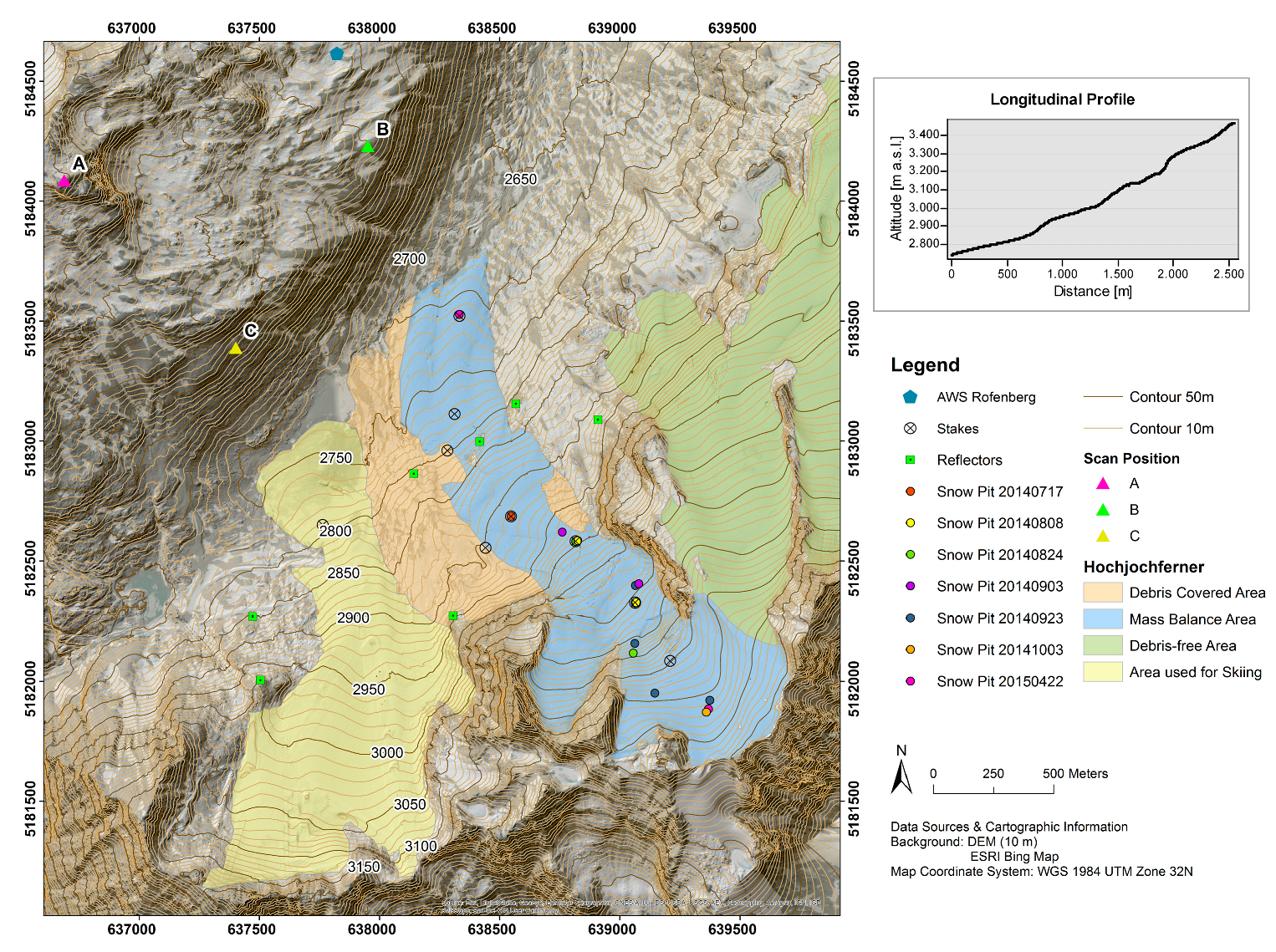
2.1. The Study Site: Hochjochferner
2.2. TLS-Acquisition
2.3. TLS Processing
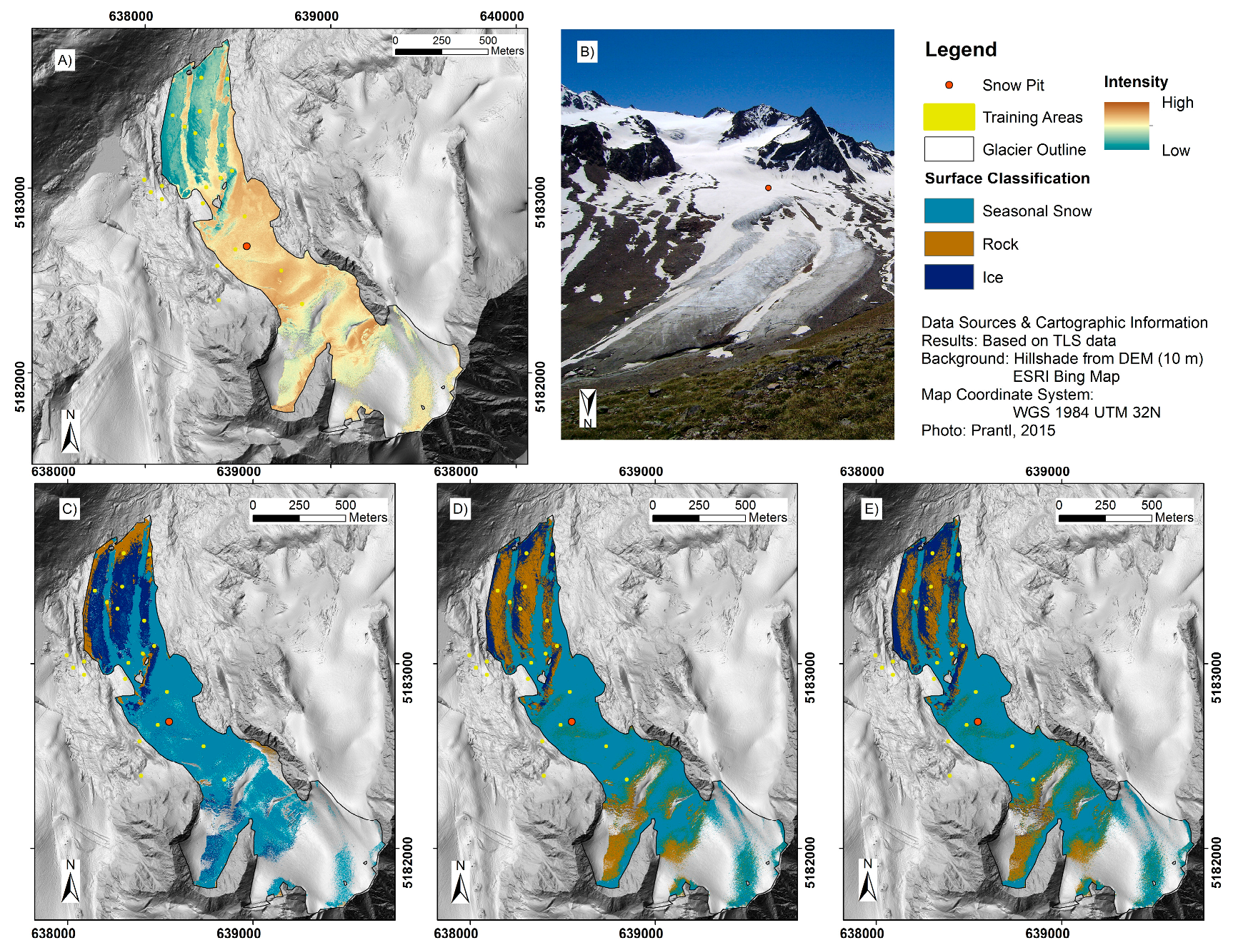
2.4. Surface Classification
2.5. Relationship between TLS Intensity and Snow Density
2.6. Calculation and Comparison of Snow Lines
3. Results and Discussion
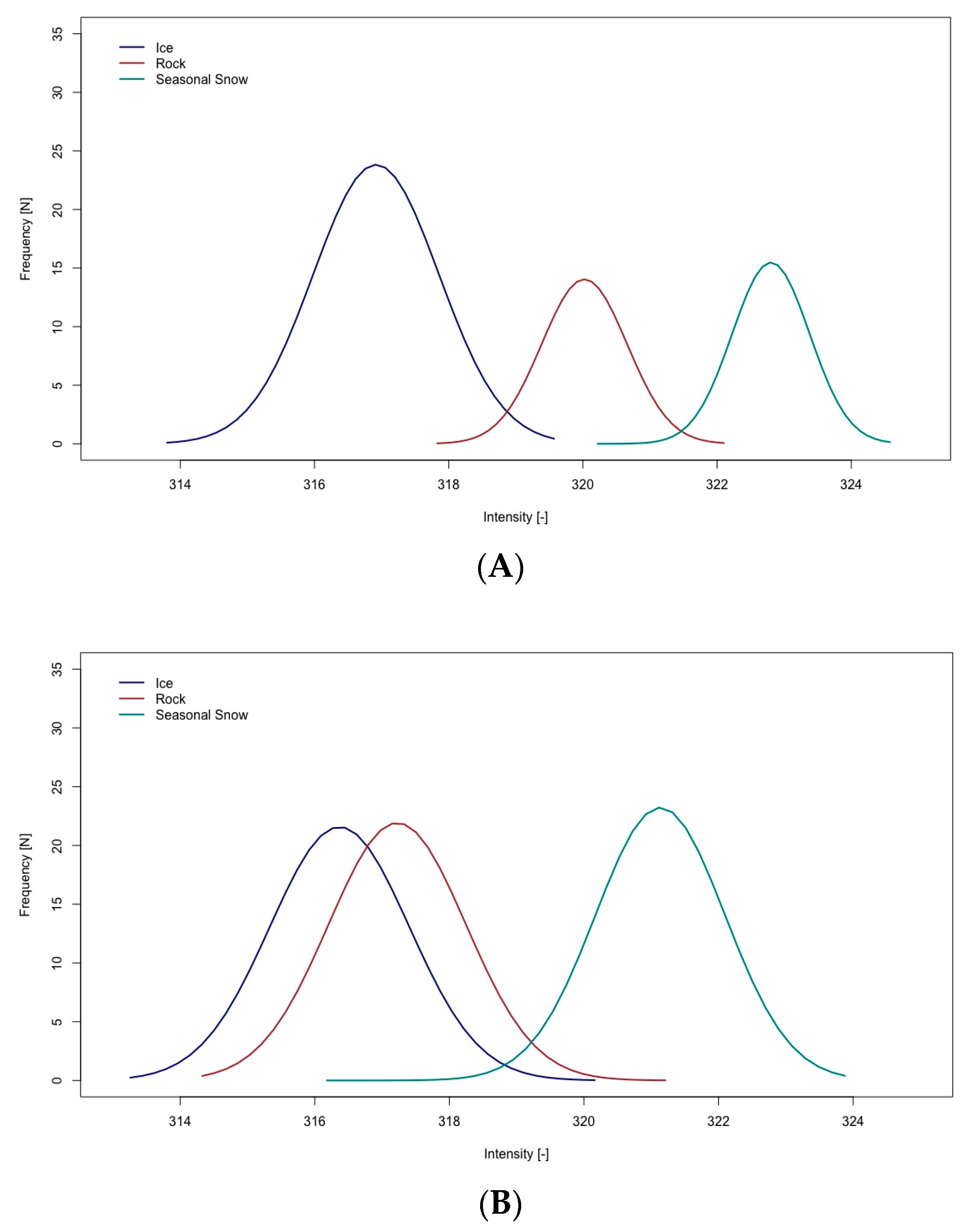
3.1. Surface Intensity and Classification
3.2. Relationship between Intensity and Density
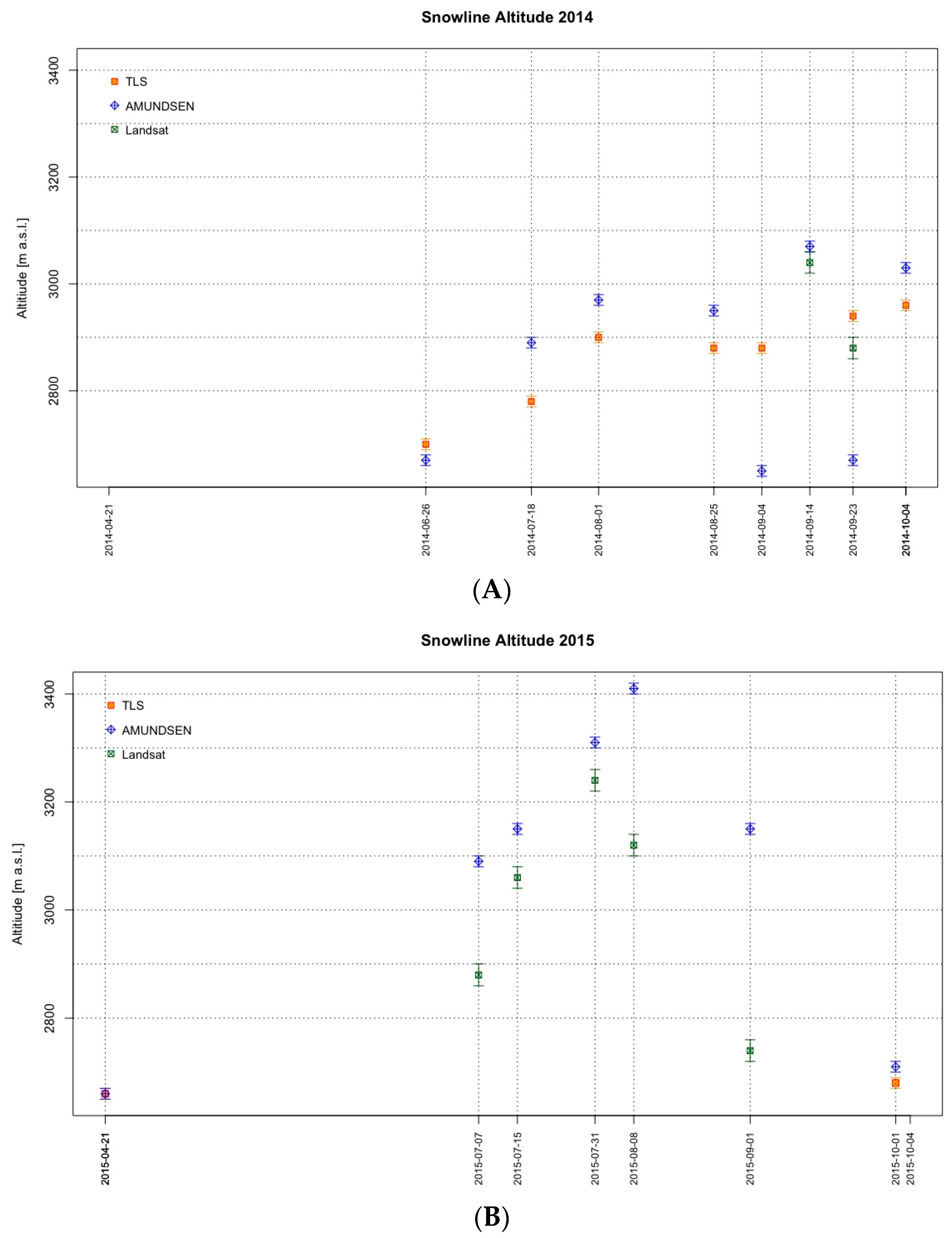
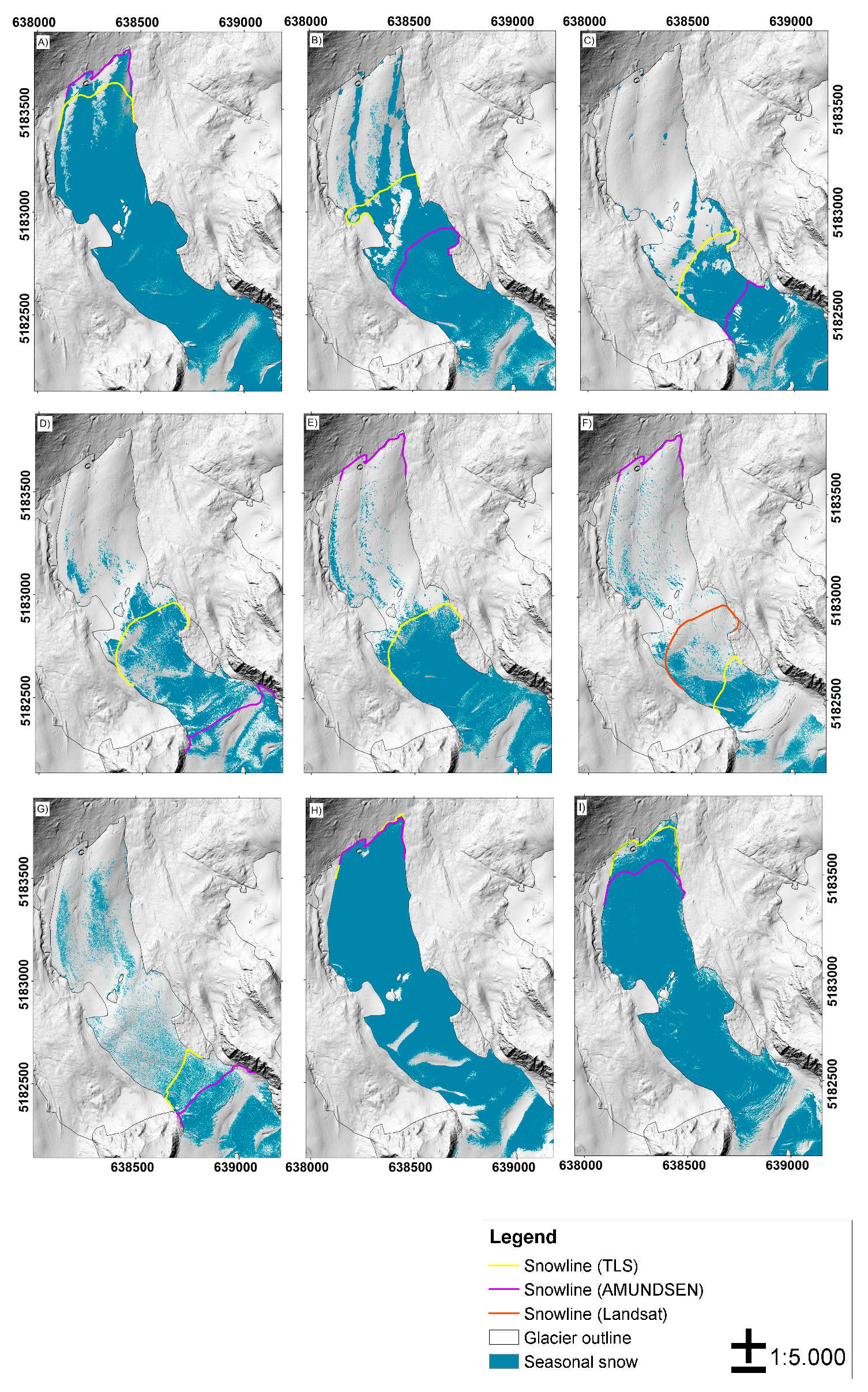
3.3. Comparison to SLA from Other Methods
4. Conclusions and Outlook
Acknowledgments
Author Contributions
Conflicts of Interest
References
- Zemp, M.; Hoelzle, M.; Haeberli, W. Six Decades of Glacier Mass-Balance Observations: A Review of the Worldwide Monitoring Network. Ann. Glaciol. 2009, 50, 101–111. [Google Scholar] [CrossRef]
- Zemp, M.; Thibert, E.; Huss, M.; Stumm, D.; Rolstad Denby, C.; Nuth, C.; Nussbaumer, S.U.; Moholdt, G.; Mercer, A.; Mayer, C.; et al. Reanalysing Glacier Mass Balance Measurement Series. Cryosphere 2013, 7, 1227–1245. [Google Scholar] [CrossRef]
- Kaser, G.; Cogley, J.G.; Dyurgerov, M.B.; Meier, M.F.; Ohmura, A. Mass Balance of Glaciers and Ice Caps: Consensus Estimates for 1961–2004. Geophys. Res. Lett. 2006, 33, 1–5. [Google Scholar] [CrossRef]
- Marzeion, B.; Jarosch, A.H.; Hofer, M. Past and Future Sea-Level Change from the Surface Mass Balance of Glaciers. Cryosphere 2012, 6, 1295–1322. [Google Scholar] [CrossRef]
- Gardner, A.S.; Moholdt, G.; Cogley, J.G.; Wouters, B.; Arendt, A.A.; Wahr, J.; Berthier, E.; Hock, R.; Pfeffer, W.T.; Kaser, G.; et al. Reconciled Estimate of Glacier Contributions to Sea Level Rise: 2003 to 2009. Science 2013, 340, 852–857. [Google Scholar] [CrossRef]
- Vaughan, D.G.; Comiso, J.C.; Allison, I.; Carrasco, J.; Kaser, G.; Kwok, R.; Mote, P.; Murray, T.; Paul, R.; Ren, J.; et al. Observations: Cryosphere. In Climate Change 2013: The Physical Science Basis; Contribution of Working Group I to the Fifth Assessment Report of the Intergovernmental Panel on Climate Change; Stocker, T.F., Qin, D., Plattner, G.-K., Tignor, M., Allen, S.K., Boschung, J., Nauels, A., Xia, Y., Bex, V., Midgley, P.M., Eds.; Cambridge University Press: Cambridge, UK; New York, NY, USA, 2014. [Google Scholar]
- Kaser, G.; Grosshauser, M.; Marzeion, B. Contribution Potential of Glaciers to Water Availability in Different Climate Regimes. Proc. Natl. Acad. Sci. USA 2010, 107, 20223–20227. [Google Scholar] [CrossRef] [PubMed]
- Marzeion, B.; Cogley, J.G.; Richter, K.; Parkes, D. Attribution of Global Glacier Mass Loss to Anthropogenic and Natural Causes. Science 2014, 919–921. [Google Scholar] [CrossRef] [PubMed]
- Slangen, A.B.A.; Church, J.A.; Agosta, C.; Fettweis, X.; Marzeion, B.; Richter, K. Anthropogenic Forcing Dominates Global Mean Sea-Level Rise since 1970. Nat. Clim. Chang. 2016, 11–16. [Google Scholar] [CrossRef]
- Radić, V.; Hock, R. Modeling Future Glacier Mass Balance and Volume Changes Using ERA-40 Reanalysis and Climate Models: A Sensitivity Study at Storglaciaren, Sweden. J. Geophys. Res. 2006, 111. [Google Scholar] [CrossRef]
- Radić, V.; Bliss, A.; Beedlow, A.C.; Hock, R.; Miles, E.; Cogley, J.G. Regional and Global Projections of Twenty-First Century Glacier Mass Changes in Response to Climate Scenarios from Global Climate Models. Clim. Dyn. 2013, 42, 37–58. [Google Scholar] [CrossRef]
- Huss, M.; Hock, R. A New Model for Global Glacier Change and Sea-Level Rise. Front. Earth Sci. 2015, 3, 1–22. [Google Scholar] [CrossRef]
- Mengel, M.; Levermann, A.; Frieler, K.; Robinson, A.; Marzeion, B.; Winkelmann, R. Future Sea Level Rise Constrained by Observations and Long-Term Commitment. Proc. Natl. Acad. Sci. USA 2016, 113, 2597–2602. [Google Scholar] [CrossRef]
- Galos, S.P.; Klug, C.; Maussion, F.; Covi, F.; Nicholson, L.; Rieg, L.; Gurgiser, W.; Mölg, T.; Kaser, G. Reanalysis of a Ten Year Record (2004–2013) of Seasonal Mass Balances at Langenferner/Vedretta Lunga, Ortler-Alps, Italy. Cryosphere 2017, 11, 1417–1439. [Google Scholar] [CrossRef]
- Klug., C.; Bollmann, E.; Prinz, R.; Galso, S.P.; Rieg, L.; Kaser, G.; Sailer, R. A detailed comparison of 10 years of annual glacier mass balance obtained by geodetic and glaciological methods at Hintereisferner, Ötztal Alps, Austria. Cryosphere 2017. in preparation. [Google Scholar]
- Pelto, M.; Kavanaugh, J.; McNeil, C. Juneau Icefield Mass Balance Program 1964–2011. Earth Syst. Sci. Data 2013, 5, 319–330. [Google Scholar] [CrossRef]
- Mernild, S.; Pelto, M.; Malmros, J.; Yde, J.; Knudsen, N.; Hanna, E. Identification of Snow Ablation Rate, ELA, AAR and Net Mass Balance using Transient Snowline Variations on two Arctic Glaciers. J. Glaciol. 2013, 59, 649–659. [Google Scholar] [CrossRef]
- Mölg, N.; Ceballos, J.L.; Huggel, C.; Micheletti, N.; Rabatel, A.; Zemp, M. Ten years of montly Mass Balance of Conejeras Glacier, Colombia, and their Evaluation using Different Interpolation Methods. Geogr. Ann. Ser. A Phys. Geogr. 2017, 1–22. [Google Scholar] [CrossRef]
- Rabatel, A.; Dedieu, J.-P.; Vincent, C. Using Remote-Sensing Data to Determine Equilibrium-line Altitude and Mass-Balance Time Series: Validation on three French Glaciers, 1994–2002. J. Glaciol. 2005, 51, 539–546. [Google Scholar] [CrossRef]
- Mizukami, N.; Perica, S. Spatiotemporal Characteristics of Snowpack Density in the Mountainous Regions of the Western United States. J. Hydrometeorol. 2008, 9, 1416–1426. [Google Scholar] [CrossRef]
- Pfeifer, N.; Briese, C. Geometrical Aspects of Airborne Laser Scanning and Terrestrial Laser Scanning; Rönnholm, P., Hyyppä, H., Hyyppä, J., Eds.; International Archives of Photogrammetry and Remote Sensing: Espoo, Finland, 2007. [Google Scholar]
- Geist, T.; Lutz, E.; Stötter, J. Airborne laser scanning technology and its potentials for applications in glaciology. In 3-D Reconstruction from Airborne Laserscanner and INSAR Data; Maas, H.G., Vosselman, G., Streilein, A., Eds.; ISPRS Workshop: Dresden, Germany, 2003. [Google Scholar]
- Sailer, R.; Bollmann, E.; Hoinkes, S.; Rieg, L.; Spross, M.; Stötter, J. Quantification of Geomorphodynamics in Glaciated and Recently Deglaciated Terrain based on Airborne Laser Scanning Data. Geogr. Ann. Ser. A Phys. Geogr. 2012, 94, 17–32. [Google Scholar] [CrossRef]
- López-Moreno, J.I.; Revuelto, J.; Alonso-Gonzáles, E. Using very long-range Terrestrial Laser Scanning to Analyze the Temporal Consistency of the Snowpack Distribution in a High Mountain Environment. J. Mt. Sci. 2017, 14, 823–842. [Google Scholar] [CrossRef]
- Blasone, G.; Cavalli, M.; Marchi, L.; Cazorzi, F. Monitoring Sediment Source Areas in a Debris-Flow Catchment using Terrestrial Laser Scanning. Catena 2004, 123, 23–36. [Google Scholar] [CrossRef]
- Gabbud, C.; Micheletti, N.; Lane, S.N. Instruments and methods. LiDAR measurements of surface melt for a temperate alpine glacier at the seasonal ad hourly scales. J. Glaciol. 2015, 61, 963–974. [Google Scholar] [CrossRef]
- Jörg, P.; Fromm, R.; Sailer, R.; Schaffhauser, A. Measuring Snow Depth with a Terrestrial Laser Ranging System. In Proceedings of the 2006 International Snow Science Workshop (ISSW), Telluride, CO, USA, 1–6 October 2006; pp. 452–460. [Google Scholar]
- Schaffhauser, A.; Fromm, R.; Joerg, P.; Luzi, G.; Noferini, L.; Sailer, R. Remote Sensing Based Retrieval of Snow Cover Properties. Cold Reg. Sci. Technol. 2008, 54, 164–175. [Google Scholar] [CrossRef]
- Sailer, R.; Fellin, W.; Fromm, R.; Jörg, P.; Rammer, L.; Sampl, P.; Schaffhauser, A. Snow Avalanche Mass-Balance Calculation and Simulation-Model Verification. Ann. Glaciol. 2008, 48, 183–192. [Google Scholar] [CrossRef]
- Prokop, A. Assessing the Applicability of Terrestrial Laser Scanning for Spatial Snow Depth Measurements. Cold Reg. Sci. Technol. 2008, 54, 155–163. [Google Scholar] [CrossRef]
- Schwalbe, E.; Maas, H.G.; Dietrich, R.; Ewert, H. Glacier Velocity Determination from Multi Temporal Terrestrial Long Range Laser Scanner Point Clouds. In Proceedings of the ISPRS Congress Beijing 2008, Beijing, China, 3–11 July 2008. [Google Scholar]
- Bauer, A.; Paar, G.; Kaufmann, V. Terrestrial Scanning for Rock Glacier Monitoring. In Proceedings of the 8th International Conference on Permafrost, Zurich, Switzerland, 21–25 July 2003. [Google Scholar]
- Kellerer-Pirklbauer, A.; Bauer, A.; Proske, H. Terrestrial Laser Scanning for Glacier Monitoring: Glaciation Changes of the Gössnitzkees Glacier (Schober Group, Austria) between 2000 and 2004. In Proceedings of the 3rd Symposium of the Hohe Tauern National Park for Research in Protected Areas, Castle of Kaprun, Austria, 15–17 September 2005; Phillips, M., Springman, S.M., Arenson, L.U., Eds.; pp. 97–106. [Google Scholar]
- Fischer, M.; Huss, M.; Kummert, M.; Hoelzle, M. Application and Validation of long-range Terrestrial Laser Scanning to Monitor the Mass Balance of very small Glaciers in the Swiss Alps. Cryosphere 2016, 10, 1279–1295. [Google Scholar] [CrossRef]
- Dumont, M.; Sirguey, P.; Arnaud, Y.; Six, D. Monitoring Spatial and Temporal Variations of Surface Albedo on Saint Sorlin Glacier (French Alps) using Terrestrial Photography. Cryosphere 2011, 5, 759–771. [Google Scholar] [CrossRef]
- Höfle, B.; Pfeifer, N. Correction of laser scanning intensity data: Data and model-driven approaches. J. Photogramm. Remote Sens. 2007, 62, 415–433. [Google Scholar] [CrossRef]
- Pfeifer, N.; Höfle, B.; Briese, C.; Rutzinger, M.; Haring, A. Analysis of the Backscattered Energy in Terrestrial Laser Scanning Data. In Proceedings of the ISPRS Congress Beijing 2008, Beijing, China, 3–11 July 2008; pp. 1045–1051. [Google Scholar]
- Jörg, P.C.; Weyermann, J.; Morsdorf, F.; Zemp, M.; Schaepman, M.E. Computation of a Distributed Glacier Surface Albedo using Airborne Laser Scanning Intensity Data and in-situ Spectro-Radiometric Measurements. Remote Sens. Environ. 2015, 160, 31–42. [Google Scholar] [CrossRef]
- Fritzmann, P.; Höfle, B.; Vetter, M.; Sailer, R.; Stötter, J.; Bollmann, E. Surface classification based on multi-temporal airborne LiDAR intensity data in high mountain environments. A case study from Hintereisferner, Austria. Z. Geomorphol. 2011, 55, 105–126. [Google Scholar] [CrossRef]
- Tiroler Landesregierung. Available online: https://www.tirol.gv.at/data/datenkatalog/geographie -und-planung/digitales-gelaendemodell-tirol/ (accessed on 20 April 2017).
- Corine Land Cover 2006 Raster Data. The European Topic Centre on Land Use and Spatial Information. Available online: http://www.eea.europa.eu/data-and-maps/data/corine-land-cover-2006-clc2006 -100-m-version-12–2009#tab-gis-data (accessed on 15 March 2014).
- Fliri, F. Das Klima der Alpen im Raume von Tirol: Monographie zur Landeskunde Tirols, 1st ed.; Wagner: Innsbruck, Austria; München, Germany, 1975. [Google Scholar]
- Kuhn, M.; Batlogg, N. Glacier Runoff in Alpine Headwaters in a Changing Climate. Hydrol. Water Resour. Ecol. Headwaters 1998, 248, 79–88. [Google Scholar]
- Kuhn, M.; Nickus, U.; Pellet, F. Die Niederschlagsverhältnisse im inneren Ötztal. In 17. Internationale Tagung für Alpine Meteorologie, Berchtesgaden, Germany, 21–25 September 1982; Selbstverlag des Deutschen Wetterdienstes: Offenbach, Germany, 1982. [Google Scholar]
- Kuhn, M.; Dreiseitl, E.; Emprechtinger, M. Temperatur und Niederschlag an der Wetterstation Obergurgl, 1953–2011. In Klima, Wetter, Gletscher im Wandel; Koch, E.-M., Erschbamer, B., Eds.; Innsbruck University Press (IUP): Innsbruck, Austria, 2013; Volume 9, pp. 11–31. [Google Scholar]
- Kuhn, M.; Abermann, J.; Olefs, M.; Fischer, A.; Lambrecht, A. Gletscher im Klimawandel: Aktuelle Monitoring Programme und Forschungen zur Auswirkung auf den Gebietsabfluss im Ötztal. In Mitteilungsblatt des hydrographischen Dienstes Österreich, 1st ed.; Austrian Ministry for Agriculture, Forestry, Environment and Water Management (BMLFUW): Vienna, Austria, 2009; Volume 86, pp. 31–47. [Google Scholar]
- Juen, I.; Kaser, G. Climate Data Vent, Ötztal Alps, 2012–2016; Dataset #876595; Pangaea: Bremen, Germany, 2017; Available online: https://doi.pangaea.de/10.1594/PANGAEA.876595 (accessed on 28 June 2017).
- Juen, I.; Kaser, G.; Niedertscheider, K. Monthly Precipitation at Gauge Station Rofenberg 1952–01 to 2016–12; Dataset #876528; Pangaea: Bremen, Germany, 2017; Available online: https://doi.pangaea.de/10.1594/PANGAEA.876528 (accessed on 28 June 2017).
- Riegl. 3-D Terrestrial Laser Scanner RIEGL VZ-4000/RIEGL VZ-6000. General Description and Data Interfaces, 3rd ed.; Riegl: Horn, Austria, 2014. [Google Scholar]
- Conrad, O.; Bechtel, B.; Bock, M.; Dietrich, H.; Fischer, E.; Gerlitz, L.; Wehberg, J.; Wichmann, V.; Böhner, J. System for Automated Geoscientific Analyses (SAGA) v. 2.1.4. Geosci. Model Dev. 2015, 8, 1991–2007. [Google Scholar] [CrossRef]
- Yunfei, B.; Guoping, L.; Chunxiang, C.; Xiaowen, L.; Hao, Z.; Qisheng, H.; Linyan, B.; Chaoyi, C. Classification of LiDAR Point Cloud and Generation of DTM from LiDAR Height and Intensity Data in Forested Area. The International Archives of the Photogrammetry, Remote Sensing and Spatial Information Sciences. In Proceedings of the ISPRS Congress Beijing 2008, Beijing, China, 3–11 July 2008. [Google Scholar]
- El-Ashmawy, N.; Shaker, A. Raster vs. Point Cloud LiDAR Data Classification. In Proceedings of the ISPRS Technical Commission VII Symposium, Istanbul, Turkey, 29 September–2 October 2014. [Google Scholar]
- Wagner, W.; Ullrich, A.; Ducic, V.; Melzer, T.; Studnicka, N. Gaussian Decomposition and Calibration of a Novel Small-Footprint Full-Waveform digitising Airborne Laser Scanner. J. Photogramm. Remote Sens. 2006, 60, 100–112. [Google Scholar] [CrossRef]
- Krooks, A.; Kaasalainen, S.; Hakala, T.; Nevalainen, O. Correction of Intensity Incidence Angle Effect in Terrestrial Laser Scanning. In Proceedings of the ISPRS Workshop Laser Scanning 2013, Antalya, Turkey, 11–13 November 2013. [Google Scholar]
- Arnold, N.S.; Rees, W.G.; Devereux, B.J.; Amable, G.S. Evaluating the Potential of High-Resolution Airborne LiDAR Data in Glaciology. Int. J. Remote Sens. 2006, 27, 1233–1251. [Google Scholar] [CrossRef]
- Geist, T. Application of Airborne Laser Scanner Technology in Glacier Research. Doctor Dissertation, University of Innsbruck, Innsbruck, Austria, 2005. [Google Scholar]
- Baltsavias, E.P. A Comparison between Photogrammetry and Laser Scanning. J. Photogramm. Remote Sens. 1999, 54, 83–94. [Google Scholar] [CrossRef]
- Baltsavias, E.P. Airborne Laser Scanning: Basic Relations and Formulas. J. Photogramm. Remote Sens. 1999, 54, 199–214. [Google Scholar] [CrossRef]
- Wagner, W.; Hyyppä, J.; Ullrich, A.; Lehner, H.; Briese, C.; Kaasalainen, S. Radiometric Calibration of Full-Waveform Small-Footprint Airborne Laser Scanners. The International Archives of the Photogrammetry, Remote Sensing and Spatial Information Sciences. In Proceedings of the ISPRS Congress Beijing 2008, Beijing, China, 3–11 July 2008. [Google Scholar]
- Antilla, K.; Hakala, T.; Kaasalainen, S.; Kaartinen, H.; Nevalainen, O.; Krooks, A.; Kukko, A.; Jaakkola, A. Calibrating Laser Scanner Data from Snow Surfaces: Correction of Intensity Effects. Cold Reg. Sci. Technol. 2016, 121, 52–59. [Google Scholar] [CrossRef]
- Pfeifer, N.; Briese, C. Laser Scanning—Principles and Applications. In Proceedings of the 3rd International Exhibition and Scientific Congress GeoSiberia 2007, Novosibirsk, Russia, 25–27 April 2007. [Google Scholar]
- Albretz, J.; Wiggenhagen, M. Taschenbuch zur Photogrammetrie und Fernerkundung. In Guide for Photogrammetry and Remote Sensing, 5th ed.; Wichmann: Heidelberg, Germany, 2009. [Google Scholar]
- Richard, J.A.; Jia, W. Remote Sensing Digital Image Analysis: An Introduction, 4th ed.; Springer-Verlag: Berlin, Germany, 2006. [Google Scholar]
- ERDAS. ERDAS Field Guide, 5th ed.; ERDAS: Atrlanta, GA, USA, 1999. [Google Scholar]
- Lillesand, T.M.; Kiefer, R.W.; Chipman, J.W. Remote Sensing and Image Interpretation, 7th ed.; Wiley: Hoboken, NJ, USA, 2008. [Google Scholar]
- Höfle, B.; Geist, T.; Rutzinger, M.; Pfeifer, N. Glacier Surface Segmentation Using Airborne Laser Scanning Point Cloud and Intensity Data; Rönnholm, P., Hyyppä, H., Hyyppä, J., Eds.; International Archives of Photogrammetry and Remote Sensing: Espoo, Finland, 2007. [Google Scholar]
- Congalton, R.G.; Green, K. Assessing the Accuracy of Remotely Sensed Data: Principles and Practices, 2nd ed.; Tylor & Francis Group: Boca Raton, FL, USA, 2009. [Google Scholar]
- Zimmermann-Janschitz, S. Statistik in der Geographie. Eine Exkursion Durch Die Deskriptive Statistik, 1st ed.; Springer Spektrum: Berlin, Germany, 2014. [Google Scholar]
- Strasser, U. Die Modellierung der Gebirgsschneedecke im Nationalpark Berchtesgaden; Nationalparkverwalt. Berchtesgaden: Berchtesgaden, Germany, 2008. [Google Scholar]
- Hanzer, F.; Helfricht, K.; Marke, T.; Strasser, U. Multilevel spatiotemporal validation of snow/ice mass balance and runoff modeling in glacierized catchments. Cryosphere 2016, 10, 1859–1881. [Google Scholar] [CrossRef]
- Rastner, P.; Nicholson, L.; Sailer, R.; Notarnicola, C.; Prinz, R. Mapping the Snow Line Altitude for Large Glacier Samples from Multitemporal Landsat Imagery. In Proceedings of the 2015 8th International Workshop on the Analysis of Multitemporal Remote Sensing Images (Multi-Temp), Annecy, France, 22–24 July 2015. [Google Scholar]
- Deems, J.S.; Painter, T.H.; Finnegan, D.C. LiDAR Measurements of Snow Depth: A Review. J. Glaciol. 2013, 59, 467–479. [Google Scholar] [CrossRef]
- Kaasalainen, S.; Hyyppä, H.; Kukko, A.; Litkey, P.; Ahokas, E.; Hyyppä, J.; Lehner, H.; Jaakkola, A.; Suomalainen, J.; Akujärvi, A.; et al. Radiometric Calibration of LiDAR Intensity with Commercially Available Reference Targets. IEEE Trans. Geosci. Remote Sens. 2009, 2, 588–598. [Google Scholar] [CrossRef]
- Kaasalainen, S.; Kaartinen, H; Kukko, A. Snow Cover Change Detection with Laser Scanning Range and Brightness Measurements. EARSeL Eproc. 2008, 7, 133–141. [Google Scholar]
- Hollaus, M.; Mandlburger, G.; Pfeifer, N.; Mücke, W. Land Cover Dependant Derivation of Digital Surface Models from Airborne Laser Scanning Data; Paparoditis, N., Pierrot-Deseilligny, M., Mallet, C., Tournaire, O., Eds.; IAPRS: Saint-Mandé, France, 2010. [Google Scholar]
- Paul, F.; Winsvold, S.H.; Kääb, A.; Nagler, T.; Schwaizer, G. Glacier Remote Sensing Using Sentinel-2. Part II: Mapping Glacier Extents and Surface Facies, and Comparison to Landsat 8. Remote Sens. 2016, 8, 1–15. [Google Scholar] [CrossRef]


| Mean Air Temperature (°C) (without the Gap in July) | Vent Precipitation Sum (mm) | Rofenberg Precipitation Sum (mm) | |
|---|---|---|---|
| 2013/2014 | 4.5 (2.9) | 1008 | 1145 |
| 2014/2015 | 4.7 (3.1) | 856 | 1117 |
| Difference (14–15) | −0.2 | 152 | 28 |
| 1982–2011 | 2.8 | 680 | 1088 |
| 1935–2005 | 2.3 | 674 | not available |
| Range Measurement Principle | Pulse Time of Flight |
|---|---|
| Wavelength (nm) | 1064 |
| Laser pulse repetition rate (kHz) | 30 * |
| Effective measurement (meas./s) at 30 kHz | 23,000 * |
| Min and max range (m) | 5–6000 * |
| Accuracy (mm) | 15 * |
| Precision (mm) | 10 * |
| Operating temperature (°C) | 0.0–40 |
| Max humidity (%) | 80 |
| Date | Scan Positions Used | Accuracy (m) |
|---|---|---|
| (A) 26 June 2014 | A, B, C | 0.026 |
| (B) 18 July 2014 | A, B, C | 0.03 |
| (C) 1 August 2014 | A, B, C | 0.033 |
| (D) 25 August 2014 | B, C | 0.016 |
| (E) 4 September 2014 | A, B, C | 0.023 |
| (F) 23 September 2014 | A, B, C | 0.025 |
| (G) 4 October 2014 | A, B, C | 0.03 |
| (H) 21 April 2015 | A, B, C | 0.025 |
| (I) 1 October 2015 | B, C | 0.031 |
| Date | Classification Overall Accuracy (%) | ||
|---|---|---|---|
| RBC | MLC | MDC | |
| 26 June 2014 | 100 | 85 | 84 |
| 18 July 2014 | 90 | 70 | 69 |
| 1 August 2014 | 95 | 98 | 98 |
| 25 August 2014 | 73 | 58 | 60 |
| 4 September 2014 | 90 | 73 | 73 |
| 23 September 2014 | 93 | 81 | 81 |
| 4 October 2014 | 73 | 67 | 66 |
| 21 April 2015 | 99 | 77 | 76 |
| 1 October 2015 | 88 | 74 | 75 |
| Average | 89 | 75.88 | 75.77 |
| Date | Density (kg/m3) | Intensity | |
|---|---|---|---|
| First Core | in Total | ||
| 17 July 2014 | 518 | 524 | 324.57 |
| 8 August 2014 | 508 | 509 | 323.01 |
| 8 August 2014 | 508 | 491 | 322.79 |
| 24 August 2014 | 488 | 496 | 320.13 |
| 24 August 2014 | 342 | 508 | 321.82 |
| 24 August 2014 | 304 | 466 | 320.92 |
| 3 September 2014 | 263 | 447 | 322.54 |
| 3 September 2014 | 297 | 494 | 321.78 |
| 3 September 2014 | 293 | 450 | 322.99 |
| 23 September 2014 | 458 | 479 | 321.13 |
| 23 September 2014 | 171 | 389 | 322.01 |
| 23 September 2014 | 448 | 478 | 321,63 |
| 23 September 2014 | 408 | 475 | 322.13 |
| 3 October 2014 | 383 | 526 | 324 |
| 21 April 2015 | 305 | 380 | 324.33 |
| 21 April 2015 | 305 | 397 | 334.8 |
| Date | Snowline Altitude (m a.s.l.) /AAR (%) | Difference | |||||||
|---|---|---|---|---|---|---|---|---|---|
| Snowline Altitude (m) | Snow-covered Area (m2) | ||||||||
| TLS | AMU * | Landsat | AMU-TLS | Landsat-TLS | Landsat-AMU | TLS-AMU | TLS-Landsat | Landsat-AMU | |
| 26 June 2014 | 2700/96.7% | 2670/99.9% | - | −30 | - | - | −34,676 | - | - |
| 18 July 2014 | 2780/79.1% | 2890/68.3% | - | 110 | - | - | 116,475 | - | - |
| 1 August 2014 | 2900/66.4% | 2970/57.8% | - | 70 | - | - | 93,378 | - | - |
| 25 August 2014 | 2880/70.3% | 2950/54.4% | - | 70 | - | - | 121,782 | - | - |
| 4 September 2014 | 2880/70.3% | 2650/100% | - | −230 | - | - | −320,681 | - | - |
| 14 September 2014 | 3070/50.4% | 3040/53.2% | - | - | −30 | - | - | 30,357 | |
| 22/23 September 2014 | 2940/59.8% | 2670/99.9% | 2880/70.3% | −270 | -60 | 210 | −433,254 | −113,615 | −319,639 |
| 4 October 2014 | 2960/58.4% | 3030/53.9% | - | 70 | - | - | 47,929 | - | - |
| 21 April 2015 | 2660/100% | 2660/100% | - | 0 | - | - | 0 | - | - |
| 7 July 2015 | - | 3090/47.0% | 2880/70.3% | - | - | −210 | - | - | 251,649 |
| 15 July 2015 | - | 3150/38.0% | 3060/51.6% | - | - | −90 | - | - | 146,398 |
| 31 July 2015 | - | 3310/17.2% | 3240/29.1% | - | - | −70 | - | - | 127,795 |
| 8 August 2015 | - | 3410/0.3% | 3120/43.2% | - | - | −290 | - | - | 464,586 |
| 1 September 2015 | - | 3150/38.0% | 2740/87.7% | - | - | −410 | - | - | 536,825 |
| 1 October 2015 | 2680/99.4% | 2710/95.0% | - | 30 | - | - | 47,556 | - | - |
© 2017 by the authors. Licensee MDPI, Basel, Switzerland. This article is an open access article distributed under the terms and conditions of the Creative Commons Attribution (CC BY) license (http://creativecommons.org/licenses/by/4.0/).
Share and Cite
Prantl, H.; Nicholson, L.; Sailer, R.; Hanzer, F.; Juen, I.F.; Rastner, P. Glacier Snowline Determination from Terrestrial Laser Scanning Intensity Data. Geosciences 2017, 7, 60. https://doi.org/10.3390/geosciences7030060
Prantl H, Nicholson L, Sailer R, Hanzer F, Juen IF, Rastner P. Glacier Snowline Determination from Terrestrial Laser Scanning Intensity Data. Geosciences. 2017; 7(3):60. https://doi.org/10.3390/geosciences7030060
Chicago/Turabian StylePrantl, Hannah, Lindsey Nicholson, Rudolf Sailer, Florian Hanzer, Irmgard F. Juen, and Philipp Rastner. 2017. "Glacier Snowline Determination from Terrestrial Laser Scanning Intensity Data" Geosciences 7, no. 3: 60. https://doi.org/10.3390/geosciences7030060
APA StylePrantl, H., Nicholson, L., Sailer, R., Hanzer, F., Juen, I. F., & Rastner, P. (2017). Glacier Snowline Determination from Terrestrial Laser Scanning Intensity Data. Geosciences, 7(3), 60. https://doi.org/10.3390/geosciences7030060