Abstract
Augusta Bay is an embayment of the Hyblean sector in south-eastern Sicily (Southern Italy) that faces the Ionian Sea and includes the Rada di Augusta, a wide littoral sector sheltered by breakwaters, which hosts intense harbor activities. Rada di Augusta and the adjacent Priolo embayment were listed in the National Remediation Plan (NRP) by the Italian Ministry of Environment, as they have suffered major anthropic impacts over the last seventy years. Indeed, extensive petrochemical and industrial activities, military and commercial maritime traffic, as well as agriculture and fishery activities, have resulted in a highly complex combination of impacts on the marine environment and seafloor. In this paper, we investigate the extent of human-driven physical impacts on the continental shelf, offshore of Rada di Augusta, by means of Multibeam echosounder, Side-Scan Sonar and Chirp Sonar profilers, as well as direct seabed samplings. At least seven categories of anthropogenic footprints, i.e., anchor grooves and scars, excavations, trawl marks, targets, dumping trails, isolated dumping and dumping cumuli, mark the recent human activities at the seafloor. The practice of dredge spoil disposal, possibly protracted for decades during the last century, has altered the seafloor morphology of the central continental shelf, by forming an up-to-9 m-thick hummocky deposit, with acoustic features noticeably different from those of any other shelf lithosome originated by natural processes. All available data were reported in an original thematic map of the seafloor features, offering an unprecedented opportunity to unravel sediment facies distribution and localization of anthropogenic disturbance. Finally, the shelf area was ranked, based on the coexistence of multiple stressors from human-driven physical harm, thus providing a semi-quantitative analysis of environmental damage classification in the area.
1. Introduction
The Anthropocene Epoch refers to the most recent period in Earth’s history, during which the impact of human activity began to overwhelm the planet’s climate and ecosystems. Following the super-exponential growth of the world economy, the hyper-exploitation of natural capital and the large-scale production of garbage on land [], humans are now turning their attention and expectations to resources from the sea and seafloor [] and looking for biological goods, minerals and space to be used for a variety of purposes. Namely, the number of oil rigs and platform foundations, pavement for cable communication and pipelines and disposal areas for spoil materials are exponentially increasing worldwide, with varying degrees of impact on the environment, food web and, ultimately, human health. In particular, dumping is a practice that relies on the simple idea that the ocean is large enough to incorporate and regenerate any material thrown onto the seafloor, out of human sight. The extent of dumping sites has typically been mapped using bathymetric charts and backscatter analyses, and generally lacks a three-dimensional definition []. Combining Multibeam bathymetry, Side-Scan sonar and high-resolution seismic investigations, we surveyed the continental shelf of one of the most-impacted coasts of the Mediterranean Sea, with a pollution history of almost a century. The Mediterranean covers just 0.7% of the global ocean surface but is one of the areas under major stress from a variety of conflicting uses of the marine environment [,,]. The legacy of several major industrial plants, built in coastal regions over the last century, is one of the primary problems pervasively distressing ecosystems and threatening human health. Among these sites, the Augusta/Priolo coastal area (Southern Italy, Figure 1), a ‘High Environmental Risk’ zone, as stated in 1990 by the Italian Ministry of Environment, entered the list of the National Remediation Plan (NRP), i.e., polluted sites demanding urgent and extensive remediation and restoration measures, in 1998.
Over the last 50 years, several studies have contributed to the evaluation of the impact of human activities in the harbor of Augusta (Rada di Augusta, Figure 1), focusing primarily on the distribution of priority chemical pollutants in sediments and seawater [,,]. Indeed, investigations demonstrated the effects of the bioaccumulation of dangerous chemicals in the marine trophic web, with an efficient transfer of contaminants to commercial benthic fish [,,,,,]. On the other hand, very few investigations have been carried out on the potential physical impacts of anthropogenic activities on the seabed outside the harbor, where, in fact, sustaining the integrity of the seabed is crucial to the preservation of marine ecosystems and biodiversity []. Thus, generating high-resolution thematic maps for exploring and assessing the human footprint on the seabed helps to (i) estimate the spatial coverage and scale of the transformations induced by human activity on landscape/seascape; (ii) evaluate the persistence of anthropogenic modifications to natural landforms [,]; and (iii) produce tailored approaches for appropriate planning and use of marine environments, supporting sustainable and efficient human activities [].
From this perspective, Augusta Bay represents a ‘library’ of highly heterogeneous physical anthropogenic impacts that have left a profound morphological mark on the seabed, with potential effects on the deep ecosystem. Here, we aim to (i) produce high-resolution maps of damage to the seabed from recent human activity within the Augusta Bay, from 20 m below sea level (bsl) to the shelf edge; (ii) determine and, where possible, quantify the extent of the anthropogenic footprint; (iii) produce a thematic map of the status of the seafloor in the early 2000s, as a benchmark for future monitoring or spatial planning actions; and (iv) localize offshore sectors that appear unaffected by anthropogenic damage. In this effort, the generation of high-resolution thematic mapping that considers multiple stressors is a crucial step in quantifying the extent of damaged areas and in planning actions for environmental and ecosystem recovery.

Figure 1.
(a) Morpho-bathymetry of Augusta Bay [,]; blue lines mark the main faults bounding a depocentral area (Shelf-Basin, SB) of the continental shelf; coloured dots indicate the sampling sites. Depth contours are every 5 m. Bathymetry inside Rada di Augusta harbor is from ICRAM []. (b) Track lines of Side-Scan Sonar and sub-bottom Chirp Sonar surveys. The insets above are modified from [].
2. Geographical and Geological Background
Augusta Bay is located in the western coastal sector of the Ionian Sea (Figure 1), which is characterized by high seismicity [,]. It is part of the Hyblean Plateau, pertaining to the emerged African foreland domain []. The Ionian coastal and nearshore areas are segmented into several rhombohedral-shaped horst and graben structures by the NNW-trending Malta Escarpment fault system and by several NE-SW tectonic lineaments, active since the Messinian [,,].
The offshore sector of Augusta Bay consists of a tectonically controlled narrow continental shelf, characterized by a 20 km2-wide depocentral area (Shelf-Basin, SB), bounded by morpho-structural highs. These correspond to the underwater offshoots of Mt Tauro and Magnisi– Santa Panagia horsts, made of Upper Cretaceous-Miocene carbonates, with volcanic intercalations, and shaped by several orders of terraced surfaces []. Structural lineaments have largely controlled the morphology of the shelf and minor active tectonics during the Holocene led to differential subsidence in the SB [,,,].
Geophysical data (swath bathymetry and sub-bottom Chirp Sonar profiles), core samples and correlations with the geology of emerged sectors have shown that the SB is filled with Quaternary deposits uncomfortably overlying the Upper Cretaceous-Miocene. The younger deposit is made of Holocene transgressive clayey sediments, showing plane-parallel stratification. It reaches a maximum thickness of 35 m and contains the tephra layer related to the 122 BC Etna eruption []. Locally, reflections are masked by seismic turbidity, presumably due to the presence of biogenic gas in the subsurface [,]. The Holocene deposits rest unconformably upon a forced regressive prograding wedge of poorly consolidated fine-grained sediments or continental to shallow-marine. The unconformity is accounted for by subaerial and shallow-marine erosion of the continental shelf during the Late Pleistocene sea-level fall, as well as low stand and wave reworking during the post-glacial sea-level rise, accompanied by the formation of barrier-lagoon systems above the forced-regressive wedge. Lastly, chaotic material of moderate thickness over the Holocene sediments was found in the central part of the SB [] and is the subject of in-depth study in this paper.
3. Materials and Methods
Three oceanographic cruises were dedicated to Augusta Bay, by the National Research Council of Italy between 2001 and 2004, on board the R/V Tethis and R/V Urania (Table 1). The cruises were funded by the GeoSed project (Amodio, []).

Table 1.
Summary of data acquisition surveys.
3.1. Chirp Sonar Data
Approximately 110 km of high-resolution seismic reflection data were collected by a Chirp Cap II 6600 sub-bottom profiler, hull-mounted on R/V Urania. Chirp seismic systems operate with a frequency-modulated source, pinging within a frequency band of 2 to 7 kHz. The data were processed and visualized using a Geosuite AllWorks® software package, running the following processing flow: swell filter, time-variant gain, amplitude enhancing and water column muting. Signal penetration was found to exceed 50 ms Two-Way Travel Time (TWTT) in areas with fine particle deposition. The vertical resolution is approximately 0.4 m near the seafloor. The conversion from TWTT to depth in meters was obtained assuming a wave velocity of approximately 1550 ms−1, averaged between the velocity within the water column and the first 50 ms of the seismic record below the seafloor (bsf). A first interpretation of all the Chirp Sonar dataset has already been provided in Firetto Carlino et al. [], where the shallow seismic stratigraphic and structural framework of the area was assessed.
In this work, special attention was paid to the lines acquired in the central portion of the bay in order to define the origin, thickness, extent and volume of the chaotic deposit already identified by Firetto Carlino et al. [].
3.2. Side-Scan Sonar Data
Approximately 315 km of Side-Scan Sonar (SSS) data were acquired on the shelf and upper-slope of Augusta Bay, by using a Klein 2000 tow-fish in Isis Triton Elics® platform, run at an average altitude of approximately 20 m above the seabed. The lateral swath was set at 150 m and the lines distance at 250 m, in order to guarantee 20% overlap of the acoustic images and optimal mosaicking. The SSS data were processed using the latest release of Seaview Mosaic (Moga Software® inc), designed to leverage modern computational resources, eliminating the need for data reduction techniques and guaranteeing the preservation of the true data resolution. Geometric (slant range) and radiometric corrections were then applied to each line. The normalization algorithm for Beam Angle Compensation (BAC) allowed the seamless equalization of the record along- and across-track, and also compensated the tow-fish elevation changes during navigation. Furthermore, a de-striping procedure was applied to ensure the removal of any artefacts, due to the roll movement of the tow-fish in seawater. For the proper re-positioning of the SSS lines, advanced navigation processing tools were used. This allows for precise position adjustment of each ping without any fanning effect. The final mosaicking results in a 1 m resolution acoustic image of the seafloor, obtained by assembling 48 grey-scaled SSS lines (Figure 2). Dark areas indicate high reflectivity and light areas signal high absorption or shadow zones (no reflection) beyond the seafloor reliefs. The mosaicked images of selected areas are shown at 0.5 m resolution. The SSS data processing and mosaicking procedures, now greatly improved compared to two decades ago, have enabled a more consistent and reliable interpretation of acoustic images.
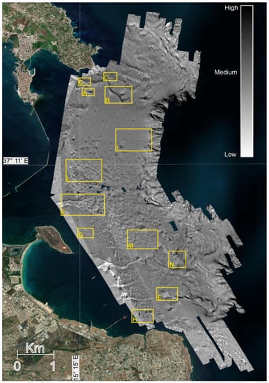
Figure 2.
Mosaicked SSS images (1 m pixel resolution) of Augusta Bay covering the shelf sector from about 20 to 250 m bsl. The image was draped over the DEM (where present) to highlight correspondence between seabed morphologies and backscatter. Yellow boxes show the location of images in the ensuing figures. Scalebar indicates the backscatter.
3.3. Samplings
A set of 28 box cores and 31 grabs were sampled from 14 to approximately 300 m bsl (Figure 1a) in order to calibrate the SSS images and define sediment textures and facies in the bay. A gravity core was acquired through the chaotic deposit of the SB (Figure 1a), in 65 m water depth and recovered 90 cm of alternating stiff mud, inhomogeneous and deformed muddy sand and coarse-grained deposits.
3.4. Multibeam Swath Bathymetry
Bathymetric data were collected by using a 95 kHz frequency Reson Sea Bat 8111. These data were processed by using PDS2000 software (Teledyne©inc) and include seafloor data ranging from 17 m to 860 m bsl. The final Digital Elevation Model (DEM) has a 10 m resolution grid cell size (see [,] for further details).
4. Results
4.1. Anthropogenic Footprint at the Seabed
The analysis of high-resolution acoustic images provided detailed information on multiple coherent patterns generated by human activities which have left a distinct footprint at the seabed (Figure 3 and Figure 4). The interpretation was carried out by comparing them to similar images of anthropic impacts reported in the literature [,,,,,].
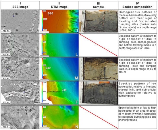
Figure 3.
Mosaicked acoustic images of the seabed showing footprints of human activities (I column); SSS mosaic matches the topography of the seabed well (II column); seabed samples serve to calibrate acoustic images (III column); description of the acoustic facies and possible interpretation (IVcolumn). The location of I-N boxes is reported in Figure 2.
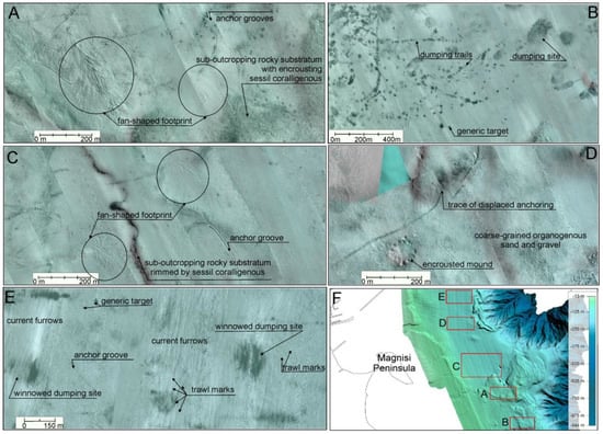
Figure 4.
Selected acoustic images of the seabed and: (A) and (C) anchor grooves leave deep furrows in the seabed; associated fan-shaped scars occasionally develop at the end of the slick and seem to pertain to anchor chain abrasion on the sea bed; (B) acoustic images of dumping trails and sites are easily distinguishable by backscatter contrast between discharged materials and pre-existing sediments; (D) trace of an anchor chain displacement; (E) dredge spoils dumping sites, winnowed by seabed currents and trawl fisheries; (F) location of A-E.
4.1.1. Bottom Trawl Marks, Anchoring Grooves and Scars
Large areas with bottom trawling and anchor marks are shown by the SSS mosaic in the central sector of Augusta Bay, over a total area of approximately 30 km2. Trawl marks (TMs) are imaged in the SSS data as narrow and sharp furrows, creating long, linear and straight patterns of stripes at the seabed (Figure 4), generally aligned along, or slightly diverging from, the isobaths. The width of TM is equal to that of the trawl gear, which is often towed in pairs, resulting in parallel-running couples of furrows [,]. Trawl marks are more distinctive when shaped in a fine-grained seabed, where both seemingly fresh and reworked traces are distinguishable for kilometres. Those found in deep water settings, i.e., on the outer shelf-upper slope, are dark-shadowed and less distinct compared to those found on the shelf. They show a more chaotic pattern and, at places, wide-radius bends, indicating reversals in the ship heading (Supplementary Materials).
A well-preserved, intricate and densely-spaced pattern of anchor grooves is evident in the SSS records (Figure 2, Figure 3 and Figure 4). Although these traces are not detectable by DEM, it is reasonable to interpret the projected shadow, with respect to the acoustic SSS source, as evidence of furrow-like features, up to 4 m large. In a few cases, fan-shaped patterns, composed of sets of curved scars, are seen to be associated with the groove (Figure 4A,C), and diverging from its termination. A great number of these fan-shaped patterns are oriented towards the southeast, i.e., in a down current direction, with respect to the dominant current flow []. We interpret these features as the scars of chain anchors rasping the seabed, as a result of the vessel drifting. In some cases, TMs, grooves and chain scars overprint old and apparently fresh dumping marks (see 4.1.3), thus disrupting and dispersing dredge spoils from their original disposal sites.
Anchor grooves are concentrated primarily in the central sector of the bay, off the Scirocco inlet, in the depth range of 50–80 m (Supplementary Material), where ships likely stand at anchor, waiting to enter Augusta Harbor. Several tracks are oriented in the direction of the harbor inlet and clearly converge toward it, thus supporting the hypothesis that they are anchor grooves. Due to the high-density of anchor furrows and their intricacy in some sectors, polygons were drawn to represent the concentration of footprints (Supplementary Materials), while long linear symbols, where traceable, represent individual marks (Figure 3 and Figure 4).
4.1.2. Dredging
Marine dredging is a sub-aquatic digging activity carried out on the seafloor for various purposes (mining, recovery of material for beach nourishment, installation of infrastructure, digging to favour navigation, etc.). No evidence of dredging is present at the seabed in the Bay, with the exclusion of the inlet channel of the Rada di Augusta, which is maintained for navigation (Supplementary Material). In particular, a deep conduit is evident at the Levante inlet, whose walls were excavated in the loose sediment and in the substratum, starting from the depth of 23 m bsl, i.e., the top of the abrasion terrace (Figure 1a; []). The depth of the inlet channel in the section immediately outside the breakwater corresponds to the artificially deepened seafloor inside the harbor, as revealed by the bathymetric survey carried out by Istituto Centrale per la Ricerca Scientifica e Tecnologica Applicata al Mare (ICRAM) [].
4.1.3. Dumping-Related Features
Offshore sediment dumping is produced by discarding dredge spoils in the marine environment. Dumping sites tend to be easily recognisable in the offshore area through high-resolution SSS survey due to their backscatter contrast, which is generated by differences in grain size, roughness, compactness and density between the dumped material and the pre-existing seabed sediments. Footprints of dumping activity appear as circular, highly reflective spots above the intermediate- to low-reflective original fine-grained seabed (Figure 4B,E), characterizing the SB. Dumping sites are much more easily identifiable when radial ribbons form, diverging over a wider circular area from the central point of discharge. Radial ribbons are generated by the granules avalanching from the topmost sediment pile and tend to restore the angular rest of grains along a natural and more stable hip [].
On the Augusta Bay shelf, several tens of sub-circular marks of dumped material are identifiable over an area of approximately 20 km2 (Figure 4 and Supplementary Materials). Marks can be seemingly fresh (highly contrasting with respect to the original seafloor), dappled (poorly contrasting with respect to pre-existent seafloor, but still showing distinct nucleus) or winnowed (marks have blunt edges, shapes are no longer sub-rounded, but deformed by post-depositional disturbance). Dumping sites may or may not correspond to localized seafloor reliefs, depending on the quantity of discharged material, density of dumping sites and post-depositional dispersion caused by natural forcing (seafloor currents) or by human activities (fisheries, anchoring, etc.). The DEM reveals an area of approximately 7.6 km2, characterized by a rough and mottled surface, with three gentle sub-circular, mound-shaped reliefs (Figure 5A,B). Based on the acoustic energy reflected back from the subsurface—high-amplitude, transparent or chaotic reflections—and on the SSS echoes—irregularly scattering spots and stripes-, Firetto Carlino et al. [] classified such features as related to a chaotic deposit; however, they did not surmise any specific process of emplacement. Here, we can infer an anthropogenic origin of this deposit, based on its internal reflections, ecographic characteristics, geometrical shape and seabed features [,] (Figure 5). Chirp Sonar profiles show sediment aggradation over the original flat bottom (white dashed line), which thus represents the natural, ancient seabed, preceding the onset of dredge spoil dumping activity. The white dotted lines (Figure 5D) mark the progressive aggradation of the deposits and suggest several phases of disposal, always in the same area (thus, perhaps through the use of an authorized disposal site) and over time. The area of maximum thickness in the dumped pile, shown in the Chirp Sonar profiles (Figure 5), corresponds to an area with coalescent dumping marks that, in the SSS images, lack an obvious backscatter contrast, as dozens of footprints pile on top of each other so that the original, un-impacted seafloor is completely buried.
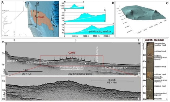
Figure 5.
Example of anthropic-impacted seafloor in correspondence of a 9 m high pile of dumped dredge spoils. (A) Extent of the shelf area characterized by rough/mottled seafloor and marked by anthropic-induced seafloor aggradation; (B) topography of the seabed across the main depocenters of dumped materials (location of profiles is in (A)); (C) isopach (m) of two cumuli above the pre-dumping seafloor; (D) Chirp Sonar profile (Ag2) across the highest cumulus and site of the gravity core described in (E) the gravity core was sampled at the topmost site of the cumulus; (F) enlarged and un-interpreted detail of the dredge spoil cumulus.
A 3D modelling of the basal surface, detected on the Chirp Sonar profiles, allows the volume between the DEM and the basal surface itself to be computed, in order to estimate the size of the dumped dredge spoil (Figure 5A,C). Unfortunately, the seismic survey has intercepted only two of the three reliefs highlighted by the DEM, given the rather widely spaced seismic grid; consequently, the isopach map in Figure 5C depicts only part of the volumes in question. Considering a seismic wave velocity of 1550 ms-1 for time/space conversion, the volume of the dumped cumuli is in the order of 107m3.
The topmost section of the dumped material (Figure 5D) was sampled by the 90 cm long gravity core C2015 (Figure 5E). The sediment record is characterized by sharp transitions between gravel-supported mud, including angular to jagged coarse particles and sparse remnants of Posidonia oceanica leaves, and muddy deposits with a large texture. Oxidation bands pervade sediments between 0.1 and 0.2 m bsf; 0.25 and 0.3 m bsf; and 0.45 and 0.55 m bsf. This condition is rather anomalous and suggests recurrent massive and abrupt covering of former dredge spoils.
The topmost 6–8 cm bsf consist of homogeneous mud with a thin shadowed band of oxidation at the sediment-seawater interface; this mud may represent the post-dumping natural sedimentation within the SB.
A further category of human-induced alteration of the seabed consists of peculiar alignments of decametric-wide stripes, composed by high-backscatter spots, organized to form almost 1 km long trails. The spots are regularly spaced and progressively decreasing in size (Figure 3 and Figure 4B). These traces may be generated by the settlement on the seafloor of discharged materials from vessels while underway. Dumping trails are predominantly observable on fine-grained seafloor sediments, characterized by low and uniform backscatter, as the dotted swipes are highly contrasted against it. The area impacted by dumping trails is located in the central-southern sector of the Bay, and it broadens to approximately 1 km2 (Supplementary Materials). We also observed a correlation between areas significantly affected by anchorages and traces of dumping trails.
4.1.4. Generic Targets
Approximately three dozen unidentified targets have been localized by SSS mosaics (Figure 4B,E). Generic targets are characterized by very sharp boundaries, marked and homogenous backscatter, sometimes projecting acoustic shadows, which denote objects elevated above the seafloor. Only objects with dimensions above the resolution of the SSS (at least >4 m2) and of mapping accuracy (1:5000) were detected (Supplementary Materials). Among these, only wider targets are visible on DEM, given that the grid cell is 10 m.
The nature of the generic targets is uncertain, and its interpretation requires further, more detailed and dedicated surveys.
4.2. Seemingly Undamaged Seafloor
Despite the pervasive human impact affecting the continental shelf, some sectors of the study area still appear pristine in the SSS images. In particular, very few anthropic marks have been detected on the terraced underwater offshoots of Mt Tauro and Magnisi–Santa Panagia Cape highs (Figure 1), which are typically characterized by a speckled backscatter of medium to high intensity, produced by the marked roughness of the seafloor. These sectors are floored, in fact, by coarse-grained organogenous and bioclastic sediments pertaining to the Coastal Detritic Biocoenosis, as described on analogous morphologies in the Tyrrhenian Sea [,], while their rims are bordered with high-backscatter stripes and related shadow zones, possibly associated with sessile coralligenous colonisations (Figure 6B,C,E) [].
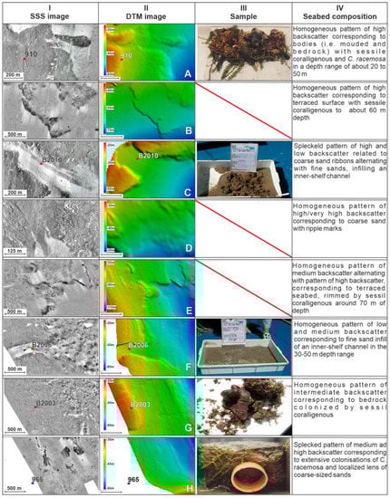
Figure 6.
Side-Scan Sonar mosaic on the continental shelf of Augusta Bay (localization of zoomed images is in Figure 2, A–H), in areas seemingly free from physical damage (I column); DEM of the seabed (II column); seabed samples serve to calibrate acoustic images (III column); description of the acoustic facies and possible interpretation (IV column).
The acoustic facies in the inner shelf of the southern bay, calibrated by the direct samples, point to the presence of extensive colonisation by Caulerpa racemosa J. Agardh, 1873 (Figure 6H), as well as small-sized, high reflective spots, regularly spaced in plain view. Some of the spotty reflections project a blunt acoustic shadow. Groups of closely spaced spotty reflections constitute wide, highly reflective and inhomogeneous patches, possibly indicating a denser net of C. racemosa stolons, or their coexistence over organogenous and bioclastic sand and gravel []. The external boundary of this facies is at approximately 50 m bsl, whereas patches are sited in the 44–47 m depth range. Random and wider-spaced spots, possibly still related to C. racemosa colonisations, may exceed 53 m depth.
No clear acoustic images of P. oceanica have been found, despite winnowed leaf detritus sometimes being present in the samples off Mt Tauro, Santa Panagia Cape and Porto Xifonio and many authors report on its occurrence [,,]. This could be due to the limited landward extension of the SSS data, which is almost always deeper than the habitat of the aquatic plant. However, the acoustic signal bouncing back from the very rough sea floor may hide possible isolated and spotty colonies of P. oceanica as well as C. racemosa (Figure 6A).
Locally, rock fall deposits were found at the base of the morpho-structural highs. Such features can be traced to the carbonate substratum cropping out at the seabed, whose pattern in the acoustic data, in turn, reflects that of the rocky cliffs of the emerged sectors.
No dumping sites were detected in this sector of the continental shelf, nor were relevant anthropogenic traces of any other nature, even though bottom trawling and anchor’ dragging may not have produced such relevant and persistent scratches and grooves as those found in the fine-grained floor of the SB. Other sectors apparently lacking physical harm by anthropogenic impact are the offshore area of Mt Tauro and the northern portion of the SB. Here, aside from several furrows produced by bottom currents and a few TMs, no relevant artificial feature seems to break the low backscatter characterizing the sandy/muddy seafloor.
Some subrounded high-contrasting dark patches occurring off the Marina di Melilli embayment, in the range-depth 20–50 m, are still undefined (Figure 6G,H). Finally, the southernmost part of the study area, offshore of Santa Panagia Cape, lacks evidence of footprints of human-driven damage.
5. Discussion
5.1. The Need to Investigate the Seabed of Augusta Bay
It is recognized that an exhaustive assessment of the geo- and chemical-hazards induced by highly polluted marine-coastal areas would require additional analysis beyond the perimeter of contaminated sites []. Further studies are needed to identify potential disposal zones outside of contaminated areas and for assessing the advection-diffusion dynamics of pollutants once they have been introduced into coastal areas. From this perspective, our study reports on multiple physical human-driven stressors in the Augusta Bay, significantly affecting the structure and natural morphology of the seabed with potential risks of triggering widespread re-suspension and dispersion of pollutants in the marine environment.
5.2. Anthropogenic Physical Impact at the Seabed
Bottom trawling, among other fishery techniques which affect the seabed, has a significant impact on benthic habitats worldwide. Fishing gears scour the seabed, and the resulting furrows remain temporarily in the sediment as deep marks which can be recognized in the acoustic signal of SSS and MBES [,,]. The penetration of the trawling gear into the seabed and the persistence of the TMs were shown to be higher in muddy sediments compared to sandy sediments. According to Depestele et al. [], the persistency of TM is variable and depends on the scour depth, nature of seabed sediment (loose, muddy, loose coarse-grained or hard seafloor) and environmental dynamics at the seabed (wave-base impact, seabed currents, hyperpycnal flows, etc.), as well as on the possible further overprinting of subsequent fishing activities. Traces may last for a few days in infralittoral environments, to years in deeper waters. Effects on the seabed are multi-fold and also affect non-targeted organisms by direct physical damage to benthic fauna or, indirectly, by alteration of the habitat, for instance, through the flattening of small-sized bedforms, disrupting of burrows, varying sediment textures and structures [,].
Evidences of TMs in the Augusta Bay are preserved in the outer shelf (Supplementary Materials) at a depth ranging between 70 and 200 m bsl. TMs are more frequent in the central sector of the bay, where the seabed is almost smooth. Only a few traces are found along the hard seabed, colonised by encrusting organisms or characterized by outcropping bedrock. Traces of TM are also preserved in the surroundings of the canyon heads, where, possibly, environmental conditions favour trophic interactions and foraging opportunities for fish [].
TMs in the Augusta Bay take on a different significance from other non-human impacted contexts, as we observed that they also cross dumping sites and piles (Figure 4 and Supplementary Material). In fact, here, this activity may have a great impact as it can spread contaminants from the dumping piles to the surrounding seafloor and in the water column through resuspension and, lastly, alter the normal process of post-dumping sediment aggradation of uncontaminated sediments, which, if undisturbed, may ideally seal the dumped spoils [,].
Maritime traffic in the central-southern bay is very intense and many vessels stay at anchor for prolonged periods. Traces of anchoring are therefore widespread in Augusta Bay (Figure 4 and Supplementary Material). However, a denser mash of traces is found deeper than 30 m bsl offshore of Marina di Melilli and Levante inlet (Supplementary Material). We assume that this observation could be biased by the following factors: (i) lack of data in the inner shelf shallower than 30 m bsl, in the Marina di Melilli, Priolo and Porto Xifonio embayments; (ii) presence of coarse-grained sediments on terraced surfaces down to 60 m bsl [], which are less conducive to trace preservation, compared to the muddy sediments in the outer shelf []. Thus, we cannot exclude that this type of physical harm extends further than observed so far.
5.3. The dumping Site Issue
Open sea dumping of dredge sediment is a common practice adopted by major harbors to excavate the seabed and for the navigation and mooring of high-draft vessels. At present, this activity is regulated by very strict international policies [,].
The recognition of dumping areas is becoming a common topic, as the exploration of the deep-sea continues and improves [,]. Nonetheless, reports on dumping sites through seismic investigations remain rare [].
Firetto Carlino et al. [] already identified the chaotic deposit in the seismic record of the Augusta Bay, but no hypothesis was reported regarding the depositional process. In this study, re-processing and re-interpretation of the SSS records allowed us to observe a more certain spatial correspondence between single and coalescent dumping, depicted by the acoustic images of the seabed and anomalous relief at the seafloor, highlighted by DEM. We have also benefited from the existing knowledge and recent reports on human footprints on the seabed [,] in endorsed areas of disposal in the North Sea [,] and off the harbor of Rio de Janeiro [].
We can infer that the chaotic deposit has a non-natural origin, based on the following topographic, morphological and stratigraphic considerations: (i) no relevant fluvial input feeds the continental shelf in this area; (ii) no slide scar, nor steep slopes are observable in the shelf areas up dip of the deposit, furthermore, the deposit is surrounded, landward, by wide terraced surfaces that are almost flat and covered by a very thin veneer of undisturbed coarse sediments; (iii) one of the three mounds (Figure 5A,B) is close to the shelf break, and therefore far away from any possible source from the mainland; (iv) the chaotic body conformably overlies the underlying continental shelf reflections and no evidence of erosion is visible; (v) the three mounds are round-shaped in plain view. Altogether, these evidences suggest a fallout of materials from above-positioned point sources and exclude any possible flux from lateral yields. Indeed, all distinctive features related to sediment drift are also missing, such as asymmetrical geometry of mounds in plain view, onlap terminations of seismic reflections above the internal discontinuities, lateral truncations of seismic reflections against the seafloor and moats [,]. Additionally, as observed from the cored section, vertical transitions among textures are sharp, not at all gradational, as would be expected for drift mounds, and include lenses of entirely unsorted, coarse-grained deposits with mollusc fragments and Rhodophyceous algae. Anomalous oxidation bands throughout the sediment section document an altered stratigraphic record. Assuming these piles are dumping deposits of dredge spoils, the unconformable contact between the coarse clasts-supported deposit with the underlying cohesive stiff muddy sediments marks two superimposing discharging events, in which a partial sorting during fall through the water column followed the release from the vessel []. The topmost 6–8 cm of homogeneous mud below the present-day seafloor may mark the recent natural deposition which has sealed the dredge spoil, at least in the area surrounding the C2015 core.
A rough estimate of the age of the dumping activity in the bay can be attempted by considering the thickness of the post-dumping drape (6–8 cm) in the core and the natural annual depositional rate, evaluated by the seismic sections. The calculation was computed in the SB at a depth of approximately 65 m, i.e., the same depth of the core (Figure 4) in an area not affected by dumping, considering as tie points the depth of the 122 BC Etna tephra marker [] (Figure 5D) and the seafloor, which represents AD 2004, i.e., the year of the seismic survey. Thus, the estimated depositional rate, averaged over the last 2.12 ky, is 2.24 ± 0.3 mmy−1. Consequently, assuming that the sediment drape, which seals the dredge spoil deposit, is completely preserved in the core and has also aggraded at this rate over the dumping deposit, the disposal of dredge spoils (at the C2015 site) should not be more recent than the 1980s. This rough estimate does not rule out the possibility that other disposal sites may have been generated or re-used more recently.
References report recurrent dredging activities in the Rada di Augusta, mainly in the 1970s and 1980s, although different volumes were involved. Bathymetric maps developed by ICRAM [] show sharp, sub-angular and straight-featured isobaths. The sharp boundaries between classes of isobaths (Figure 1) and the squared-off shape of the harbor seabed can be attributed to dredging operations [,,,]. In addition, a description of dredging activities has been reported by annals of harbor authorities and hearings by parliamentary committees on waste cycle issues and related environmental offences, which also mention an unspecified disposal site localized 5.5 km off the coast, in a deep channel running parallel to the coast [].
Despite these reports and the startling outcomes of our surveys, we are nevertheless unable to state with certainty that the deposit is a disposal from the Rada di Augusta.
5.4. Mapping the Density of Physical Harm Traces
The overlapping marks from dense anchor grooves nets, bottom trawls and dumping trails, along with countless dumping features and the presence of numerous undefined objects all at the same place, constitute a multi-hazard state of anthropogenic impact. Furthermore, if dumped dredge spoils contained pollutants, they could act as a secondary source of contamination through reworking, re-suspension and transport under the combined action of natural processes and long-lasting anthropogenic activities, with unpredictable effects on the marine environments [,,].
For these reasons, there is an urgent need to quantify the extent of physical harm, in order to evaluate the seafloor integrity [] and provide a benchmark for future appraisals.
A procedure to quantify physical harm at the seabed of Augusta Bay is proposed here as a way for enhancing the qualitative thematic mapping shown in the Supplementary Material. Being mindful of the concept of combined stressors [], we charted the impacted area, considering that, according to a holistic model, multiple harmful processes, when acting on the same spatial scale, though perhaps not on the same temporal scale, may exceed the sum of individual hazards.
The area covered by the SSS mosaic was subdivided into 500 m wide squared cells. Within each cell, marks relative to the features of the seven categories of physical harm were counted at 1: 5000 observation scale, using a GIS-based software (Global Mapper®), and a score was given by establishing a priority between categories, based on criteria reported in Table 2.
Table 2.
Score to grid cell based on the numerical count of physical harm features.
The greatest significance is given to the presence of dumping cumuli and sites within a cell, as it highlights the occurrence of anthropogenic materials of uncertain origin, followed by anchor grooves, which deeply excavate and rework the seabed. Therefore, when more than 10 anchor grooves are recorded in a single cell, a score of 2 is given for that category. Similarly, if more than 5 dumping sites are recorded, a score of 3 is given to the cell for that category. The occurrence of TMs, generic targets, dumping trails or excavation within a cell is awarded a score of 1 for each category, regardless of the number of elements in each.
To evaluate the hazard increase driven by the coexistence of more than one single footprint of impacting activity within the same cell, an additional incremental score is attributed to it, as combined stressors might reinforce each other, with unpredictable effects on the environment. The incremental value takes into account the combined presence of more than one category of physical harm within the same cell, based on the following criteria: in the coexistence of 2 categories, the score is raised by 2; in the coexistence of 3 categories, the score is raised by 4; in the coexistence of 4 categories, the score is raised by 6; in the coexistence of 5 categories, the score is raised by 8; in the coexistence of 6 or 7 categories, the score is raised by 10.
This ranking can produce a potential maximum score of 21, in the unlikely event that all categories of damage coexist in the same cell and related features are in large numbers.
As expected, the application of this method highlights that the greatest hazard associated with physical harm, detectable by SSS images, is off the Priolo shore and Levante inlet, in the range depth 50–100 m, and offshore of the Magnisi Peninsula, in the 75–100 m bsl range (Figure 7), due to the presence of the voluminous anthropogenic deposit, along with single, isolated dumping, dumping trails and anchor grooves and scars at the seafloor. Conversely, the terraced underwater offshoots of Mt Tauro, Magnisi and Santa Panagia Cape highs (Figure 1) are characterized by low rankings. Grey cells denoted non-ranked areas, due to the occurrence of doubtful features in SSS images, whose interpretation is uncertain.
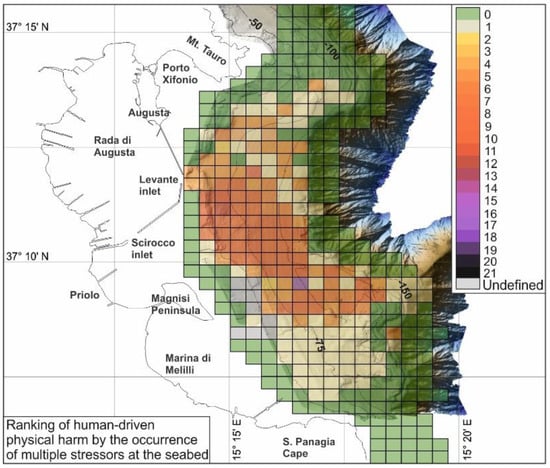
Figure 7.
Synoptic map of Augusta Bay, reporting a semi-quantitative estimate of physical harm at seabed.
6. Concluding Remarks
An investigation of the human-driven physical impact on the seafloor of Augusta Bay (Western Ionian Sea, Southern Italy), by means of acoustic remote data and direct seabed sampling, revealed seven categories of anthropogenic footprint from recent human activities, with higher concentrations observable in the central sector of the bay, between 50 and 100 m bsl. These included anchor grooves and scars, excavations, trawl marks, generic targets, dumping trails, isolated dumping and dumping cumuli. Two of the seabed marks (i.e., fan-shaped scars and dumping trails) are described for the first time and cautiously attributed to anchor chain abrasion and dumping settlement from vessels while underway, respectively. A voluminous mounded deposit, possibly resulting from offshore disposal of dredge spoils, characterized by rough seabed and distinctive seismic-acoustic facies, was also identified and measured. The dumping activity has altered the depth of the continental shelf seafloor over an area of approximately 7.6 km2 and formed three sub-circular piles, reaching a maximum thickness of approximately 9 m.
An original thematic map of the seafloor was generated at 1:47,000 scale to be adopted as a reference benchmark, relative to the early 2000s, for future monitoring of additional human impacts vs. restoration initiatives and, in general, for spatial planning actions in the area.
A specific rank of 21 classes was attributed to discretized seafloor cells, to quantify the amount of physical harm impacting the seabed. This method provides a semi-quantitative state of the art report on the multi-hazard impact on the seafloor. The adopted methodological approach illustrates the urgent need to quantify anthropogenic damages of seafloor at a high-resolution spatial scale. This could offer crucial advances to learn more on the effects of human impact on the delicate seafloor environment and its ecosystem and, consequently, provide a solid basis for environmental protection and restoration.
Supplementary Materials
The following supporting information (Augusta Bay seabed map) can be downloaded at: https://www.mdpi.com/article/10.3390/jmse10111737/s1.
Author Contributions
Conceptualization, F.B., S.I., S.P. and F.T.; methodology, F.B., M.F.C. and S.I.; validation, F.B., M.F.C. and S.P.; formal analysis, F.B., M.F.C. and S.I.; investigation, F.B., S.P. and R.T.; resources, F.B.; data curation, F.B., M.F.C. and S.I.; writing—original draft preparation, F.B., M.F.C., S.I. and M.S.; writing—review and editing, F.B., M.F.C., S.P., M.S. and F.T.; visualization, F.B., M.F.C. and S.I.; supervision, F.B., M.S. and F.T.; funding acquisition, F.B. All authors have read and agreed to the published version of the manuscript.
Funding
The geophysical surveys were supported by the Cluster 10, Project 4 funded to CNR by the Italian Ministry of University, Scientific and Technological Research (MURST) in 2000-2004.
Institutional Review Board Statement
Not appliable.
Informed Consent Statement
Not appliable.
Data Availability Statement
Geophysical data are available from Francesca Budillon upon request.
Acknowledgments
The authors are grateful for the excellent services provided by the crew of the R/V Thetys and Urania during the oceanographic cruises. The authors would also like to thank Giovanni de Alteriis for helpful comments during the data analysis, Chengbin Wang, Gwo-Shyh Song and an anonymous reviewer for their insightful advice that enabled the manuscript to be significantly improved.
Conflicts of Interest
The authors declare no conflict of interest.
References
- Zalasiewicz, J.; Colin, N.W.; Ivar do Sul, J.A.; Corcoran, P.L.; Barnoskye, A.D.; Cearreta, A.; Edgeworthg, M.; Gałuszka, A.; Jeandel, C.; Leinfelder, R.; et al. The geological cycle of plastics and their use as a stratigraphic indicator of the Anthropocene. Anthropocene 2016, 13, 4–17. [Google Scholar] [CrossRef]
- Iglesias, V.; Vannière, B.; Jouffroy-Bapicot, I. Emergence and Evolution of Anthropogenic Landscapes in the Western Mediterranean and Adjacent Atlantic Regions. Fire 2019, 2, 53. [Google Scholar] [CrossRef]
- Trincardi, F.; Francocci, F.; Pellegrini, C.; Ribera d’Alcalà, M.; Sprovieri, M. The Mediterranean Sea in the Anthropocene. In Oceanography of the Mediterranean Sea, An Introductory Guide; Shroeder, K., Chiggiato, J., Eds.; Elsevier: Amsterdam, The Netherlands, 2023; pp. 501–553. [Google Scholar]
- Francocci, F.; Cappelletto, M.; Fava, F.; Trincardi, F. The BlueMed Pilot Action Healthy Plastic-Free Mediterranean. Bull. Geophys. Oceanogr. 2021, 62, 105–111. [Google Scholar]
- Cappelletto, M.; Santoleri, R.; Evangelista, L.; Galgani, F.; Garcés, E.; Giorgetti, A.; Fava, F.; Herut, B.; Hilmi, K.; Kholeif, S.; et al. The Mediterranean Sea we want. Ocean. Coast. Res. 2021, 69, e21031. [Google Scholar] [CrossRef]
- Istituto Centrale per la Ricerca Scientifica e Tecnologica Applicata al Mare (ICRAM). Progetto Preliminare di bonifica dei fondali della rada di Augusta nel sito di Interesse Nazionale di Priolo—Elaborazione definitiva, BoI-Pr-SI-PR-Rada di Augusta-03.22; ICRAM: Roma, Italy, 2008; 182p. [Google Scholar]
- Salvagio Manta, D.; Bonsignore, M.; Oliveri, E.; Barra, M.; Giaramita, L.; Mazzola, S.; Sprovieri, M. Fluxes and the mass balance of mercury in Augusta Bay (Sicily, southern Italy). Estuar. Coast. Shelf Sci. 2016, 181, 134–143. [Google Scholar] [CrossRef]
- Feo, M.L.; Bagnati, R.; Passoni, A.; Riva, F.; Salvagio Manta, D.; Sprovieri, M.; Traina, A.; Zuccato, E.; Castiglioni, S. Pharmaceuticals and other contaminants in waters and sediments from Augusta Bay (southern Italy). Sci. Total Environ. 2020, 739, 139827. [Google Scholar] [CrossRef]
- Di Leonardo, R.; Bellanca, A.; Capotondi, L.; Cundy, A.; Neri, R. Possible impacts of Hg and PAH contamination on benthic foraminiferal assemblages: An example from the Sicilian coast, central Mediterranean. Sci. Total Environ. 2007, 388, 168–183. [Google Scholar] [CrossRef]
- Sprovieri, M.; Oliveri, E.; Di Leonardo, R.; Romagno, E.; Ausili, A.; Gabellini, M.; Barra, M.; Tranchida, G.; Bellanca, A.; Neri, R.; et al. The key role played by the Augusta basin (southern Italy) in the mercury contamination of the Mediterranean Sea. J. Environ. Monit. 2011, 13, 1753–1760. [Google Scholar] [CrossRef]
- Croudace, I.W.; Romano, E.; Ausili, A.; Bergamin, L.; Rothwell, R.G. X-Ray Core Scanners as an Environmental Forensics Tool: A Case Study of Polluted Harbour Sediment (Augusta Bay, Sicily). In Micro-XRF Studies of Sediment Cores. Developments in Paleo-environmental Research; Croudace, I.W., Rothwell, R.G., Eds.; Springer: Dordrecht, Netherlands, 2015; Volume 17, pp. 393–421. [Google Scholar] [CrossRef]
- Signa, G.; Mazzola, A.; Di Leonardo, R.; Vizzini, S. Element-specific behaviour and sediment properties modulate transfer and bioaccumulation of trace elements in a highly contaminated area (Augusta Bay, Central Mediterranean Sea). Chemosphere 2017, 187, 230–239. [Google Scholar] [CrossRef]
- Traina, A.; Ausili, A.; Bonsignore, M.; Fattorini, D.; Gherardi, S.; Gorbi, S.; Quinci, E.; Romano, E.; Salvagio Manta, D.; Tranchida, G.; et al. Organochlorines and Polycyclic Aromatic Hydrocarbons as fingerprint of exposure pathways from marine sediments to biota. Mar. Pollut. Bull. 2021, 170, 112676. [Google Scholar] [CrossRef]
- Romano, E.; Bergamin, L.; Croudace, I.W.; Pierfranceschi, G.; Sesta, G.; Ausili, A. Measuring anthropogenic impacts on an industrialised coastal marine area using chemical and textural signatures in sediments: A case study of Augusta Harbour (Sicily, Italy). Sci. Total Environ. 2021, 755, 142683. [Google Scholar] [CrossRef] [PubMed]
- Council of the European Communities. Directive 2008/56/EC of the European Parliament and of the Council of 17 June 2008 establishing a framework for Community action in the field of marine environmental policy Marine Strategy Framework Directive). Off. J. Eur. Union 2008, 164, 19–40. [Google Scholar]
- Latocha, A. The geomorphological map as a tool for assessing human impact. J. Maps 2009, 7, 103–107. [Google Scholar] [CrossRef]
- Bracchi, V.A.; Marchese, F.; Savini, A.; Chimienti, G.; Mastrototaro, F.; Tessarolo, C.; Cardone, F.; Tursi, A.; Corselli, C. Seafloor integrity of the Mar Piccolo Basin (Southern Italy): Quantifying anthropogenic impact. J. Maps 2016, 12, 1–11. [Google Scholar] [CrossRef]
- Firetto Carlino, M.; Di Stefano, A.; Budillon, F. Seismic facies and seabed morphology in a tectonically controlled continental shelf: The Augusta Bay (offshore eastern Sicily, Ionian Sea). Mar. Geol. 2013, 335, 35–51. [Google Scholar] [CrossRef]
- Budillon, F.; Ferraro, L.; Hopkins, T.S.; Iorio, M.; Lubritto, C.; Sprovieri, M.; Bellonia, A.; Marzaioli, F.; Tonielli, R. Effects of intense anthropics settlement of coastal areas on seabed and sedimentary systems: A case study from the Augusta Bay (Southern Italy). Rend. Online Della Soc. Geol. Ital. 2008, 3, 142–143. [Google Scholar]
- Firetto Carlino, M.; Cavallaro, D.; Coltelli, M.; Cocchi, L.; Zgur, F.; Patanè, D. Time and space scattered volcanism of Mt. Etna driven by strike-slip tectonics. Sci. Rep. 2019, 9, 12125. [Google Scholar] [CrossRef] [PubMed]
- Smedile, A.; De Martini, P.M.; Bellucci, L.; Gasperini, L.; Sagnotti, L.; Del Carlo, P.; Polonia, A.; Pantosti, D.; Barbano, M.S.; Gerardi, F. Paleo-tsunami deposits in the Augusta Bay area (Eastern Sicily, Italy): Preliminary results from offshore data. Rend. Online Soc. 2008, 3, 15–18. [Google Scholar]
- Smedile, A.; De Martini, P.M.; Pantosti, D.; Bellucci, L.; Del Carlo, P.; Gasperini, L.; Pirrotta, C.; Polonia, A.; Boschi, E. Possible tsunami signatures from an integrated study in the Augusta Bay offshore (Eastern Sicily-Italy). Mar. Geol. 2011, 281, 1–13. [Google Scholar] [CrossRef]
- Burollet, P.F.; Mugniot, G.M.; Sweeney, P. Geology of the Pelagian Block: The margin and basin of Southern Tunisia and Tripolitania. In The Ocean Basin and Margin; Nairn, A., Kanes, W., Stelhi, F.G., Eds.; Plenum: New York, NY, USA, 1978; pp. 331–419. [Google Scholar]
- Torelli, L.; Grasso, M.; Mazzoldi, G.; Peis, D. Plio-Quaternary tectonic evolution and structure of the Catania foredeep the northern Hyblean Plateau and the Ionian shelf (SE Sicily). Tectonophysics 1998, 298, 209–221. [Google Scholar] [CrossRef]
- Pirrotta, C.; Barbano, M.S.; Pantosti, D.; De Martini, P.M. Evidence of active tectonics in the Augusta Basin (eastern Sicily, Italy) by Chirp sub-bottom sonar investigation. Ann. Geophys. 2013, 56, S0562. [Google Scholar]
- Amodio, S.; Bellonia, A.; Budillon, F.; D’Argenio, B.; De Lauro, M.; De Simone, G.; Ferraro, L.; Iorio, M.; Molisso, F.; Russo, G.; et al. Studio GEOmorfologico e SEDimentologico in Aree Selezionate Della Piattaforma Continentale dell’Italia Meridionale (GEOSED); Project Report; IAMC, CNR: Napoli, Italy, 2005; Available online: https://eprints.bice.rm.cnr.it/id/eprint/4307.
- Friedlander, A.M.; Boehlert, G.W.; Field, M.E.; Mason, J.E.; Gardner, J.V.; Dartnell, P. Side-scan sonar mapping of benthic trawl marks off Eureka, California. Fish. Bull. 1999, 97, 786–801. [Google Scholar]
- Smith, C.J.; Rumohr, H.; Karakassis, I.; Papadopoulou, K.N. Analysing the impact of bottom trawls on sedimentary seabeds with sediment profile imagery. J. Exp. Mar. Biol. Ecol. 2003, 285–286, 479–496. [Google Scholar] [CrossRef]
- Lafferty, B.; Quinn, R.; Breen, C. A side-scan sonar and high-resolution Chirp sub-bottom profile study of the natural and anthropogenic sedimentary record of Lower Lough Erne, northwestern Ireland. J. Archaelogical Sci. 2006, 33, 756–766. [Google Scholar] [CrossRef]
- Greene, H.G.; Endris, C.; Vallier, T.; Golden, N.; Cross, J.; Ryan, H.; Dieter, B.; Niven, E. Sub-tidal benthic habitats of central San Francisco Bay and offshore Golden Gate area—A review. Mar. Geol. 2013, 345, 31–46. [Google Scholar] [CrossRef]
- de Macedo Dias, T.G.; Fontana Luiz, H.P.; Guizan Silva, C.; Cuellar de Oliveira e Silva, R.; Cavalcanti Oliveira, U.; da Silva Lima, L.; Baptista Neto, J.A.; Monteiro da Fonseca, E. Geomorphic and sedimentary impacts on the continental shelf after accumulated dredge disposal from Rio de Janeiro harbor, Brazil. Braz. J. Geophys. 2019, 37, 515–528. [Google Scholar] [CrossRef]
- Puig, P.; Canals, M.; Company, J.B.; Martín, J.; Amblas, D.; Lastras, G.; Palanques, A.; Calafat, A.M. Ploughing the deep sea floor. Nature 2012, 489, 286–289. [Google Scholar] [CrossRef]
- Bruns, I.; Holler, P.; Capperucci, R.M.; Papenmeier, S.; Bartholomä, A. Identifying Trawl Marks in North Sea Sediments. Geosciences 2020, 10, 422. [Google Scholar] [CrossRef]
- Raffa, F.; Hopkins, T.S. Circulation and water mass structure over a narrow shelf, Augusta Gulf (Sicily). Chem. Ecol. 2004, 20, 249–266. [Google Scholar] [CrossRef]
- Du Four, I.; Van Lancker, V. Changes of sedimentological patterns and morphological features due to the disposal of dredge spoil and the regeneration after cessation of the disposal activities. Mar. Geol. 2008, 255, 15–29. [Google Scholar] [CrossRef]
- Savini, A.; Basso, D.; Bracchi, V.A.; Corselli, C.; Pennetta, M. Maerl-bed mapping and carbonate quantification on submerged terraces offshore the Cilento peninsula (Tyrrhenian Sea, Italy). Geodiversitas 2012, 34, 77–98. [Google Scholar] [CrossRef]
- Innangi, S.; Tonielli, R.; Romagnoli, C.; Budillon, F.; Di Martino, G.; Innangi, M.; Laterza, R.; Le Bas, T.; Lo Iacono, C. Seabed mapping in the Pelagie Islands marine protected area (Sicily Channel, southern Mediterranean) using Remote Sensing Object Based Image Analysis (RSOBIA). Mar. Geophys. Res. 2019, 40, 333–355. [Google Scholar] [CrossRef]
- De Falco, G.; Conforti, A.; Brambilla, W.; Budillon, F.; Ceccherelli, G.; De Luca, M.; Di Martino, G.; Guala, I.; Innangi, S.; Pascucci, V.; et al. Coralligenous banks along the western and northern continental shelf of Sardinia Island (Mediterranean Sea). J. Maps 2022, 1–10. [Google Scholar] [CrossRef]
- Verlaque, M.; Boudouresque, C.F.; Meinesz, A.; Gravez, V. The Caulerpa racemosa Complex (Caulerpales, Ulvophyceae) in the Mediterranean Sea. Bot. Mar. 2000, 43, 49–68. [Google Scholar] [CrossRef]
- Di Leonardo, R.; Mazzola, A.; Cundy, A.B.; Tramati, D.C.; Vizzini, S. Trace elements to rage capacity of sediments in dead Posidonia oceanica mat from a chronically contaminated marine ecosystem. Environ. Toxicol. 2017, 36, 49–58. [Google Scholar] [CrossRef] [PubMed]
- Apostolaki, E.T.; Caviglia, L.; Santinelli, V.; Cundy, A.B.; Tramati, C.D.; Mazzola, A.; Vizzini, S. The Importance of Dead Seagrass (Posidonia oceanica) Matte as a Biogeochemical Sink. Front. Mar. Sci. 2002, 9, 861998. [Google Scholar] [CrossRef]
- Tamburrino, S.; Passaro, S.; Salvagio Manta, D.; Quinci, E.; Ausili, A.; Romano, E.; Sprovieri, M. Re-shaping the “original SIN”: A need to re-think sediment management and policy by introducing the “buffer zone” concept. J. Soils Sediments 2020, 20, 2563–2572. [Google Scholar] [CrossRef]
- Krost, P.; Bernhard, M.; Werner, F.; Hukriede, W. Otter trawl tracks in Kiel Bay (Western Baltic) mapped by side-scan sonar. Meeresforschung 1990, 32, 344–353. [Google Scholar]
- Pierdomenico, M.; Bonifazi, A.; Argenti, L.; Ingrassia, M.; Casalbore, D.; Aguzzi, L.; Viaggiu, E.; Le Foche, M.; Chiocci, F.L. Geomorphological characterization, spatial distribution and environmental status assessment of coralligenous reefs along the Latium continental shelf. Ecol. Indic. 2021, 131, 108219. [Google Scholar] [CrossRef]
- Depestele, J.; Ivanović, A.; Degrendele, K.; Esmaeili, M.; Polet, H.; Roche, M.; Summerbell, K.; Teal, L.R.; Vanelslander, B.; O’Neill, F.G. Measuring and assessing the physical impact of beam trawling. ICES J. Mar. Sci. 2016, 73, i15–i26. [Google Scholar] [CrossRef]
- Grinyó, J.; Lo Iacono, C.; Pierdomenico, M.; Conlon, S.; Corbera, G.; Gràcia, E. Evidences of human impact on megabenthic assemblages of bathyal sediments in the Alboran Sea (western Mediterranean). Deep. Sea Res. Part I Oceanogr. Res. Pap. 2020, 165, 103369. [Google Scholar] [CrossRef]
- Santora, J.A.; Zeno, R.; Dorman, J.G.; Sydeman, W.J. Submarine canyons represent an essential habitat network for krill hotspots in a Large Marine Ecosystem. Scientific reports 2018, 8, 7579. [Google Scholar] [CrossRef] [PubMed]
- Suman, D. Regulation of ocean dumping by the European Economic Community. Ecol. Law Q. 1991, 18, 559–618. [Google Scholar]
- Passaro, S.; Gherardi, S.; Romano, E.; Ausili, A.; Sesta, G.; Pierfranceschi, G.; Tamburrino, S.; Sprovieri, M. Coupled geophysics and geochemistry to record recent coastal changes of contaminated sites of the Bagnoli industrial area, Southern Italy. Estuar. Coast. Shelf Sci. 2020, 246, 107036. [Google Scholar] [CrossRef]
- Sprovieri, M.; Passaro, S.; Ausili, A.; Bergamin, L.; Finoia, M.G.; Gherardi, S.; Molisso, F.; Quinci, E.M.; Sacchi, M.; Sesta, G.; et al. Integrated approach of multiple environmental datasets for the assessment of sediment contamination in marine areas affected by long-lasting industrial activity: The case study of Bagnoli (southern Italy). J. Soils Sediments 2020, 20, 1692–1705. [Google Scholar] [CrossRef]
- Madricardo, F.; Foglini, F.; Campiani, E.; Grande, V.; Catenacci, E.; Petrizzo, A.; Kruss, A.; Toso, C.; Trincardi, F. Assessing the human footprint on the seafloor of coastal systems: The case of the Venice Lagoon, Italy. Sci. Rep. 2019, 9, 6615. [Google Scholar] [CrossRef] [PubMed]
- Virtasalo, J.J.; Korpinen, S.; Kotilainen, A.T. Assessment of the Influence of Dredge Spoil Dumping on the Seafloor Geological Integrity. Front. Mar. Sci. 2018, 5, 131. [Google Scholar] [CrossRef]
- Verdicchio, G.; Trincardi, F. Short-distance variability in slope bed-forms along the Southwestern Adriatic Margin (Central Mediterranean). Mar. Geol. 2006, 234, 271–292. [Google Scholar] [CrossRef]
- Mulder, T.; Ducassou, E.; Hanquiez, V.; Principaud, M.; Fauquembergue, K.; Tournadour, E.; Chabaud, L.; Reijmer, J.; Recouvreur, A.; Gillet, H.; et al. Contour current imprints and contourite drifts in the Bahamian archipelago. Sedimentology 2019, 66, 1192–1221. [Google Scholar] [CrossRef]
- Smedile, A.; Molisso, F.; Chagué, C.; Iorio, M.; De Martini, P.M.; Pinzi, S.; Collins, P.E.F.; Sagnotti, L.; Pantosti, D. New coring study in Augusta Bay expands understanding of offshore tsunami deposits (Eastern Sicily, Italy). Sedimentology 2020, 67, 1553–1576. [Google Scholar] [CrossRef]
- Romano, E.; Bergamin, L.; Celia Magno, M.; Ausili, A. Sediment characterization of the highly impacted Augusta harbour (Sicily, Italy): Modern benthic foraminifera in relation to grain-size and sediment geochemistry. Environ. Sci. Process. Impact 2013, 15, 930–946. [Google Scholar] [CrossRef]
- Feola, A.; Lisi, I.; Salmeri, A.; Venti, F.; Pedroncini, A.; Gabellini, M.; Romano, E. Platform of integrated tools to support environmental studies and management of dredging activities. J. Environ. Manag. 2008, 166, 357–373. [Google Scholar] [CrossRef] [PubMed]
- Available online: http://documenti.camera.it/leg18/resoconti/commissioni/stenografici/html/39/audiz2/audizione/2019/10/08/indice_stenografico.0046.html# (accessed on 21 October 2022).
- Sprovieri, M.; Cucco, A.; Budillon, F.; Salvagio Manta, D.; Trincardi, F.; Passaro, S. Large-Scale Mercury Dispersion at Sea: Modelling a Multi-Hazard Case Study from Augusta Bay (Central Mediterranean Sea). Int. J. Environ. Res. Public Health 2022, 19, 3956. [Google Scholar] [CrossRef] [PubMed]
- Pirotta, E.; Thomas, L.; Costa, D.P.; Hall, A.J.; Harris, C.M.; Harwood, J.; Kraus, S.D.; Miller, P.J.O.; Moore, M.J.; Photopoulou, T.; et al. Understanding the combined effects of multiple stressors: A new perspective on a longstanding challenge. Sci. Total Environ. 2022, 831, 153322. [Google Scholar] [CrossRef]
Publisher’s Note: MDPI stays neutral with regard to jurisdictional claims in published maps and institutional affiliations. |
© 2022 by the authors. Licensee MDPI, Basel, Switzerland. This article is an open access article distributed under the terms and conditions of the Creative Commons Attribution (CC BY) license (https://creativecommons.org/licenses/by/4.0/).