Shoreline Prediction Modelling as a Base Tool for Coastal Management: The Catania Plain Case Study (Italy)
Abstract
1. Introduction
2. The Catania Coastal Plain
3. Materials and Methods
3.1. DSAS and Shoreline Change Analysis
| NDVI | : the normalized difference vegetation index |
| NIR | : near infrared |
| Red | : visible light with a wavelength of 0.630–0.680 µm |
| NDWI | : the normalized difference water index |
| Green | : visible light with a wavelength of 1.560–1.660 µm |
| SWIR1 | : short-wave infrared 1 |
| mNDWI | : the modified normalized difference water index |
| WFI | : water frequency index |
| Nwater | : the times that the pixels were calculated as water |
| Nland | : the times that the pixels were counted as land |
| NSM | : net shoreline movement |
| D | : Distance |
| SCE | : shoreline change envelope |
| EPR | : end point rate |
| T | : time |
| WLR | : weighted linear regression |
3.2. Forecasting Shoreline Position
4. Results
4.1. Catania Coastal Plain Evolution between 1972–2022
4.2. Catania Shoreline Horizons in 2032 and 2042
5. Discussion
5.1. Simeto Delta and Shoreline Evolution of the Catania Coastal Plain
5.2. Shoreline Forecasting
6. Conclusions
Author Contributions
Funding
Institutional Review Board Statement
Informed Consent Statement
Data Availability Statement
Acknowledgments
Conflicts of Interest
References
- Liao, Z.; Su, K.; Jiang, X.; Zhou, X.; Yu, Z.; Chen, Z.; Wei, C.; Zhang, Y.; Wang, L. Ecosystem and Driving Force Evaluation of Northeast Forest Belt. Land 2022, 11, 1306. [Google Scholar] [CrossRef]
- Alberico, I.; Casalbore, D.; Pelosi, N.; Tonielli, R.; Calidonna, C.; Dominici, R.; de Rosa, R. Remote Sensing and Field Survey Data Integration to Investigate on the Evolution of the Coastal Area: The Case Study of Bagnara Calabra (Southern Italy). Remote Sens. 2022, 14, 2459. [Google Scholar] [CrossRef]
- Di Stefano, A.; De Pietro, R.; Monaco, C.; Zanini, A. Anthropogenic Influence on Coastal Evolution: A Case History from the Catania Gulf Shoreline (Eastern Sicily, Italy). Ocean Coast. Manag. 2013, 80, 133–148. [Google Scholar] [CrossRef]
- Daniels, R.C. An Innovative Method of Model Integration to Forecast Spatial Patterns of Shoreline Change: A Case Study of Nags Head, North Carolina. Prof. Geogr. 1996, 48, 195–209. [Google Scholar] [CrossRef]
- Kron, W.; Steuer, M.; Löw, P.; Wirtz, A. How to Deal Properly with a Natural Catastrophe Database—Analysis of Flood Losses. Nat. Hazards Earth Syst. Sci. 2012, 12, 535–550. [Google Scholar] [CrossRef]
- Distefano, S.; Gamberi, F. Preservation of Transgressive System Tract Geomorphic Elements during the Holocene Sea Level Rise in the South-Eastern Sicilian Tyrrhenian Margin. J. Mar. Sci. Eng. 2022, 10, 1013. [Google Scholar] [CrossRef]
- Distefano, S.; Gamberi, F.; Baldassini, N.; Di Stefano, A. Quaternary Evolution of Coastal Plain in Response to Sea-Level Changes: Example from South-East Sicily (Southern Italy). Water 2021, 13, 1524. [Google Scholar] [CrossRef]
- Distefano, S.; Gamberi, F.; Borzì, L.; Di Stefano, A. Quaternary Coastal Landscape Evolution and Sea-Level Rise: An Example from South-East Sicily. Geosciences 2021, 11, 506. [Google Scholar] [CrossRef]
- Borzì, L.; Anfuso, G.; Manno, G.; Distefano, S.; Urso, S.; Chiarella, D.; Di Stefano, A. Shoreline Evolution and Environmental Changes at the NW Area of the Gulf of Gela (Sicily, Italy). Land 2021, 10, 1034. [Google Scholar] [CrossRef]
- Molina, R.; Anfuso, G.; Manno, G.; Gracia Prieto, F.J. The Mediterranean Coast of Andalusia (Spain): Medium-Term Evolution and Impacts of Coastal Structures. Sustainability 2019, 11, 3539. [Google Scholar] [CrossRef]
- Romine, B.M.; Fletcher, C.H. Armoring on Eroding Coasts Leads to Beach Narrowing and Loss on Oahu, Hawaii. In Pitfalls of Shoreline Stabilization: Selected Case Studies; Cooper, J., Andrew, G., Pilkey, O.H., Eds.; Springer: Dordrecht, The Netherland, 2012; Volume 1, pp. 141–164. [Google Scholar]
- Crowell, M.; Leatherman, S.; Buckley, M.K. Historical Shoreline Change: Error Analysis and Mapping Accuracy. J. Coast. Res. 1991, 7, 839–852. [Google Scholar]
- Davidson, M.A.; Splinter, K.D.; Turner, I.L. A Simple Equilibrium Model for Predicting Shoreline Change. Coast. Eng. 2013, 73, 191–202. [Google Scholar] [CrossRef]
- Galgano, F.A.; Douglas, B.C. Shoreline Position Prediction: Methods and Errors. Environ. Geosci. 2000, 7, 23–31. [Google Scholar] [CrossRef]
- Wright, L.D.; Short, A.D.; Green, M.O. Short-Term Changes in the Morphodynamic States of Beaches and Surf Zones: An Empirical Predictive Model. Mar. Geol. 1985, 62, 339–364. [Google Scholar] [CrossRef]
- Honeycutt, M.G.; Crowell, M.; Douglas, B.C. Shoreline-Position Forecasting: Impact of Storms, Rate-Calculation Methodologies, and Temporal Scales. J. Coast. Res. 2001, 17, 721–730. [Google Scholar]
- Crowell, M.; Douglas, B.C.; Leatherman, S.P. On Forecasting Future U.S. Shoreline Positions: A Test of Algorithms. J. Coast. Res. 1997, 13, 1245–1255. [Google Scholar]
- Davidson, S.G.; Hesp, P.; Miot da Silva, G. Rapid Shoreline Erosion and Dunefield Change, Salmon Hole, South Australia. Sci. Total Environ. 2021, 767, 145406. [Google Scholar] [CrossRef]
- Davidson, M.A.; Turner, I.L.; Splinter, K.D.; Harley, M.D. Annual Prediction of Shoreline Erosion and Subsequent Recovery. Coast. Eng. 2017, 130, 14–25. [Google Scholar] [CrossRef]
- Vitousek, S.; Barnard, P.L.; Limber, P.; Erikson, L.; Cole, B. A Model Integrating Longshore and Cross-Shore Processes for Predicting Long-Term Shoreline Response to Climate Change. J. Geophys. Res. Earth. Surf. 2017, 122, 782–806. [Google Scholar] [CrossRef]
- Turki, I.; Medina, R.; Coco, G.; Gonzalez, M. An Equilibrium Model to Predict Shoreline Rotation of Pocket Beaches. Mar. Geol. 2013, 346, 220–232. [Google Scholar] [CrossRef]
- Davidson, M.A.; Turner, I.L. A Behavioral Template Beach Profile Model for Predicting Seasonal to Interannual Shoreline Evolution. J. Geophys. Res. Earth. Surf. 2009, 114, F01020. [Google Scholar] [CrossRef]
- Yates, M.L.; Guza, R.T.; O’Reilly, W.C. Equilibrium Shoreline Response: Observations and Modeling. J. Geophys. Res. Oceans. 2009, 114, C09014. [Google Scholar] [CrossRef]
- Long, J.W.; Plant, N.G. Extended Kalman Filter Framework for Forecasting Shoreline Evolution. Geophys. Res. Lett. 2012, 39, L13603. [Google Scholar] [CrossRef]
- Kalman, R.E. A New Approach to Linear Filtering and Prediction Problems. J. Basic Eng. 1960, 82, 35–45. [Google Scholar] [CrossRef]
- Godwyn-Paulson, P.; Jonathan, M.P.; Roy, P.D.; Rodríguez-Espinosa, P.F.; Muthusankar, G.; Muñoz-Sevilla, N.P.; Lakshumanan, C. Evolution of Southern Mexican Pacific Coastline: Responses to Meteo-Oceanographic and Physiographic Conditions. Reg. Stud. Mar. Sci. 2021, 47, 101914. [Google Scholar] [CrossRef]
- Davidson, M. Forecasting Coastal Evolution on Time-Scales of Days to Decades. Coast. Eng. 2021, 168, 103928. [Google Scholar] [CrossRef]
- Natarajan, L.; Sivagnanam, N.; Usha, T.; Chokkalingam, L.; Sundar, S.; Gowrappan, M.; Roy, P.D. Shoreline Changes over Last Five Decades and Predictions for 2030 and 2040: A Case Study from Cuddalore, Southeast Coast of India. Earth Sci. Inform. 2021, 14, 1315–1325. [Google Scholar] [CrossRef]
- Ciritci, D.; Türk, T. Assessment of the Kalman Filter-Based Future Shoreline Prediction Method. Int. J. Environ. Sci. Technol. 2020, 17, 3801–3816. [Google Scholar] [CrossRef]
- Himmelstoss, E.A.; Henderson, R.E.; Kratzmann, M.G.; Farris, A.S. Digital Shoreline Analysis System (DSAS) Version 5.0 User Guide; US Geological Survey: Reston, VA, USA, 2018; pp. 1–126. [Google Scholar]
- Anzidei, M.; Scicchitano, G.; Scardino, G.; Bignami, C.; Tolomei, C.; Vecchio, A.; Serpelloni, E.; de Santis, V.; Monaco, C.; Milella, M.; et al. Relative Sea-Level Rise Scenario for 2100 along the Coast of South Eastern Sicily (Italy) by InSAR Data, Satellite Images and High-Resolution Topography. Remote Sens. 2021, 13, 1108. [Google Scholar] [CrossRef]
- Longhitano, S.; Colella, A. Geomorphology, Sedimentology and Recent Evolution of the Anthropogenically Modified Simeto River Delta System (Eastern Sicily, Italy). Sediment Geol. 2007, 194, 195–221. [Google Scholar] [CrossRef]
- Francaviglia, A. L’imbasamento Sedimentario Dell’Etna e Il Golfo Preetneo. Boll. Serv. Geol. Ital. 1962, 81, 593–684. [Google Scholar]
- Accordi, B.; Francaviglia, A. La Geologia Del Bacino Del Simeto (Geology of Simeto River Basin). Tec. Agri. 1960, 12, 221–244. [Google Scholar]
- Ben-Avraham, D.; Burschka, M.A.; Doering, C.R. Statics and Dynamics of a Diffusion-Limited Reaction: Anomalous Kinetics, Nonequilibrium Self-Ordering, and a Dynamic Transition. J. Stat. Phys. 1990, 60, 695–728. [Google Scholar] [CrossRef]
- Lentini, F.; Carbone, S.; Catalano, S.; Grasso, M. Principali Lineamenti Strutturali Della Sicilia Nord-Orientale. Stud. Geol. Cam. 1995, 2, 319–329. [Google Scholar]
- Finetti, I.; Del Ben, A. Geophysical Study of the Tyrrhenian Opening. Boll. Geofis. Teor. Appl. 1986, 28, 75–155. [Google Scholar]
- Adam, J.; Reuther, C.D.; Grasso, M.; Torelli, L. Active Fault Kinematics and Crustal Stresses along the Ionian Margin of Southeastern Sicily. Tectonophysics 2000, 326, 217–239. [Google Scholar] [CrossRef]
- Bianchi, F.; Carbone, S. Sicilia Orientale: Profilo Geologico Nebrodi-Iblei. Mem. Soc. Geol. Ital. 1987, 38, 429–458. [Google Scholar]
- Distefano, S.; Gamberi, F.; Di Stefano, A. Stratigraphic and Structural Reconstruction of an Offshore Sector of the Hyblean Foreland Ramp (Southern Italy). Ital. J. Geosci. 2019, 138, 390–403. [Google Scholar] [CrossRef]
- Gamberi, F.; Della Valle, G.; Marani, M.; Mercorella, A.; Distefano, S.; Di Stefano, A. Tectonic Controls on Sedimentary System along the Continental Slope of the Central and Southeastern Tyrrhenian Sea. Ital. J. Geosci. 2019, 138, 317–332. [Google Scholar] [CrossRef]
- Catalano, S.; Di Stefano, A.; Distefano, S.; Pavano, F.; Romagnoli, G.; Tortorici, G.; Tortorici, L. New Insights on the Role of the Strike-Slip Tectonics in the Late Miocene-Quaternary Evolution of Sicily. Int. J. Geosci. 2019, 10, 689–708. [Google Scholar] [CrossRef]
- Regione Siciliana Bacino Idrografico Del Fiume Simeto (094) Area Territoriale Tra Il Bacino Del Fiume Simeto e Il Bacino Del Fiume San Leonardo (094A) Lago Di Pergusa (094B) Lago Di Maletto (094C). Available online: https://www.sitr.regione.sicilia.it/pai/bac094-simeto.htm (accessed on 17 September 2022).
- Quang, D.N.; Ngan, V.H.; Tam, H.S.; Viet, N.T.; Tinh, N.X.; Tanaka, H. Long-Term Shoreline Evolution Using DSAS Technique: A Case Study of Quang Nam Province, Vietnam. J. Mar. Sci. Eng. 2021, 9, 1124. [Google Scholar] [CrossRef]
- Hu, X.; Wang, Y. Monitoring Coastline Variations in the Pearl River Estuary from 1978 to 2018 by Integrating Canny Edge Detection and Otsu Methods Using Long Time Series Landsat Dataset. CATENA 2022, 209, 105840. [Google Scholar] [CrossRef]
- Nithu, R.; Gurugnanam, B.; Sudhakar, V.; Francis, P.G. Estuarine Shoreline Change Analysis Along the Ennore River Mouth, South East Coast of India, Using Digital Shoreline Analysis System. Geod. Geodyn. 2019, 10, 205–212. [Google Scholar] [CrossRef]
- Awad, M.; El-Sayed, H.M. The Analysis Of Shoreline Change Dynamics and Future Predictions Using Automated Spatial Techniques: Case of El-Omayed on the Mediterranean Coast of Egypt. Ocean Coast. Manag. 2021, 205, 105568. [Google Scholar] [CrossRef]
- Aladwani, N.S. Shoreline Change Rate Dynamics Analysis and Prediction of Future Positions Using Satellite Imagery for the Southern Coast of Kuwait: A Case Study. Oceanologia 2022, 64, 417–432. [Google Scholar] [CrossRef]
- Pons, X.; Pesquer, L.; Cristóbal, J.; Guerrero, O.G. Automatic and Improved Radiometric Correction of Landsat Imagery Using Reference Values from MODIS Surface Reflectance Images. Int. J. Appl. Earth Obs. Geoinf. 2014, 33, 243–254. [Google Scholar] [CrossRef]
- López-Serrano, P.M.; Corral-Rivas, J.J.; Díaz-Varela, R.A.; álvarez-González, J.G.; López-Sánchez, C.A. Evaluation of Radiometric and Atmospheric Correction Algorithms for above Ground Forest Biomass Estimation Using Landsat 5 TM Data. Remote Sens. 2016, 8, 369. [Google Scholar] [CrossRef]
- Knight, E.J.; Kvaran, G. Landsat-8 Operational Land Imager Design, Characterization and Performance. Remote Sens. 2014, 6, 10286–10305. [Google Scholar] [CrossRef]
- Taloor, A.K.; Manhas, D.S.; Kothyari, G.C. Retrieval of Land Surface Temperature, Normalized Difference Moisture Index, Normalized Difference Water Index of the Ravi Basin Using Landsat Data. Appl. Comput. Geosci. 2021, 9, 100051. [Google Scholar] [CrossRef]
- Cohen, W.B.; Healey, S.P.; Yang, Z.; Zhu, Z.; Gorelick, N. Diversity of Algorithm and Spectral Band Inputs Improves Landsat Monitoring of Forest Disturbance. Remote Sens. 2020, 12, 1673. [Google Scholar] [CrossRef]
- Hashmi, S.G.M.D.; Ahmad, S.R. GIS-Based Analysis and Modeling of Coastline Erosion and Accretion Along the Coast of Sindh Pakistan. J. Coast. Zone Manag. 2018, 21, 1000455. [Google Scholar] [CrossRef]
- Ghebrezgabher, M.G.; Yang, T.; Yang, X.; Sereke, T.E. Assessment of NDVI Variations in Responses to Climate Change in the Horn of Africa. Egypt. J. Remote Sens. Space Sci. 2020, 23, 249–261. [Google Scholar]
- Özelkan, E. Water Body Detection Analysis Using NDWI Indices Derived from Landsat-8 OLI. Polish J. Environ. Stud. 2020, 29, 1759–1769. [Google Scholar] [CrossRef] [PubMed]
- Laksono, F.A.T.; Czirok, L.; Borzi, L.; Di Stefano, A.; Halmai, A.; Kovacs, J. Shoreline Change Dynamics along the Augusta Coast, Eastern Sicily, South Italy. Environ. Dev. Sustain. 2022, submitted.
- Syvitski, J.P.M.; Vörösmarty, C.J.; Kettner, A.J.; Green, P. Impact of Humans on the Flux of Terrestrial Sediment to the Global Coastal Ocean. Science 2005, 308, 376–380. [Google Scholar] [CrossRef] [PubMed]
- Kim, J.; Choi, J.; Choi, C.; Hwang, C. Forecasting the Potential Effects of Climatic and Land-Use Changes on Shoreline Variation in Relation to Watershed Sediment Supply and Transport. J. Coast. Res. 2017, 33, 874–888. [Google Scholar] [CrossRef]
- Anthony, E.J. Wave Influence in the Construction, Shaping and Destruction of River Deltas: A Review. Mar. Geol. 2015, 361, 53–78. [Google Scholar] [CrossRef]
- Mammì, I.; Rossi, L.; Pranzini, E. Mathematical Reconstruction of Eroded Beach Ridges at the Ombrone River Delta. Water 2019, 11, 2281. [Google Scholar] [CrossRef]
- Sanchez-Arcilla, A.; Jimenez, J.A.; Valdemoro, H.I. The Ebro Delta: Morphodynamics and Vulnerability. J. Coast. Res. 1998, 14, 754–772. [Google Scholar]
- Distefano, S.; Baldassini, N.; Barbagallo, V.; Borzì, L.; D’Andrea, N.M.; Urso, S.; Di Stefano, A. 3D Flooding Maps as Response to Tsunami Events: Applications in the Central Sicilian Channel (Southern Italy). J. Mar. Sci. Eng. 2022, 10, 1953. [Google Scholar] [CrossRef]
- Laksono, F.A.T.; Kovács, J. Application of the PTVA–4 Modeling in Assessment of Building Vulnerability to Earthquake and Tsunami: A Simple and Reliable Method for Preliminary Study of Tsunami-Prone Zones. Acad. Perspect. Proc. 2022, 5, 243–252. [Google Scholar] [CrossRef]
- Distefano, S.; Gamberi, F.; Baldassini, N.; Di Stefano, A. Late Miocene to Quaternary structural evolution of the Lampedusa island offshore. Geo. Fis. Din. Quat. 2018, 41, 17–31. [Google Scholar]
- Distefano, S.; Gamberi, F.; Baldassini, N.; Di Stefano, A. Neogene stratigraphic evolution of a tectonically controlled continental shelf: The example of the Lampedusa island. Int. J. Geosci. 2019, 138, 418–431. [Google Scholar] [CrossRef]
- Saxena, S.; Purvaja, R.; Suganya, G.M.D.; Ramesh, R. Coastal Hazard Mapping in the Cuddalore Region, South India. Nat. Hazards 2013, 66, 1519–1536. [Google Scholar] [CrossRef]
- Sriganesh, J.; Saravanan, P.; Mohan, V.R. Remote Sensing and GIS Analysis on Cuddalore Coast of Tamil Nadu, India. Natl. Conf. Coast. Environ. 2015, 2, 94–108. [Google Scholar]
- Mukhopadhyay, A.; Mukherjee, S.; Mukherjee, S.; Ghosh, S.; Hazra, S.; Mitra, D. Automatic Shoreline Detection and Future Prediction: A Case Study on Puri Coast, Bay of Bengal, India. Eur. J. Remote Sens. 2012, 45, 201–213. [Google Scholar] [CrossRef]

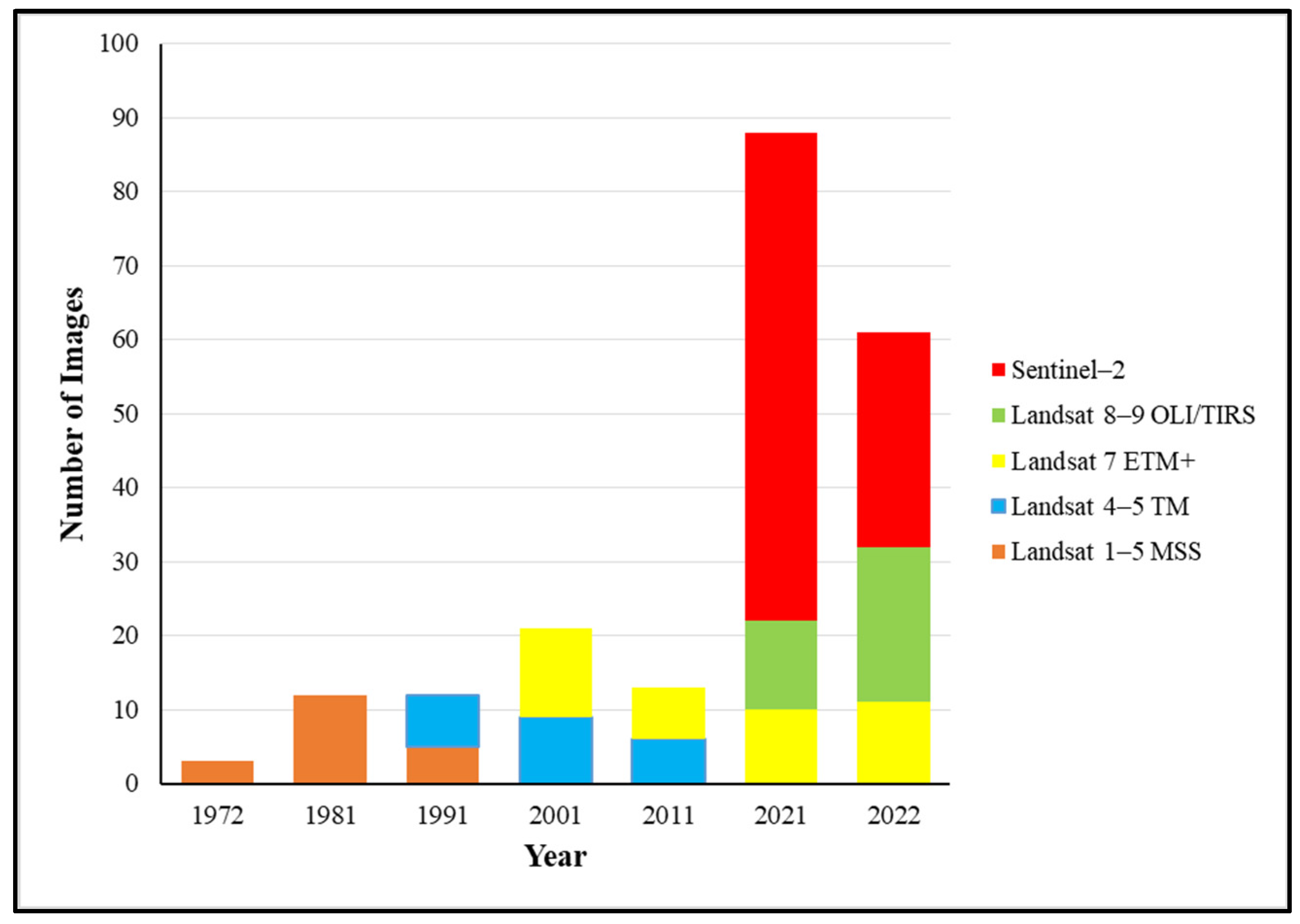

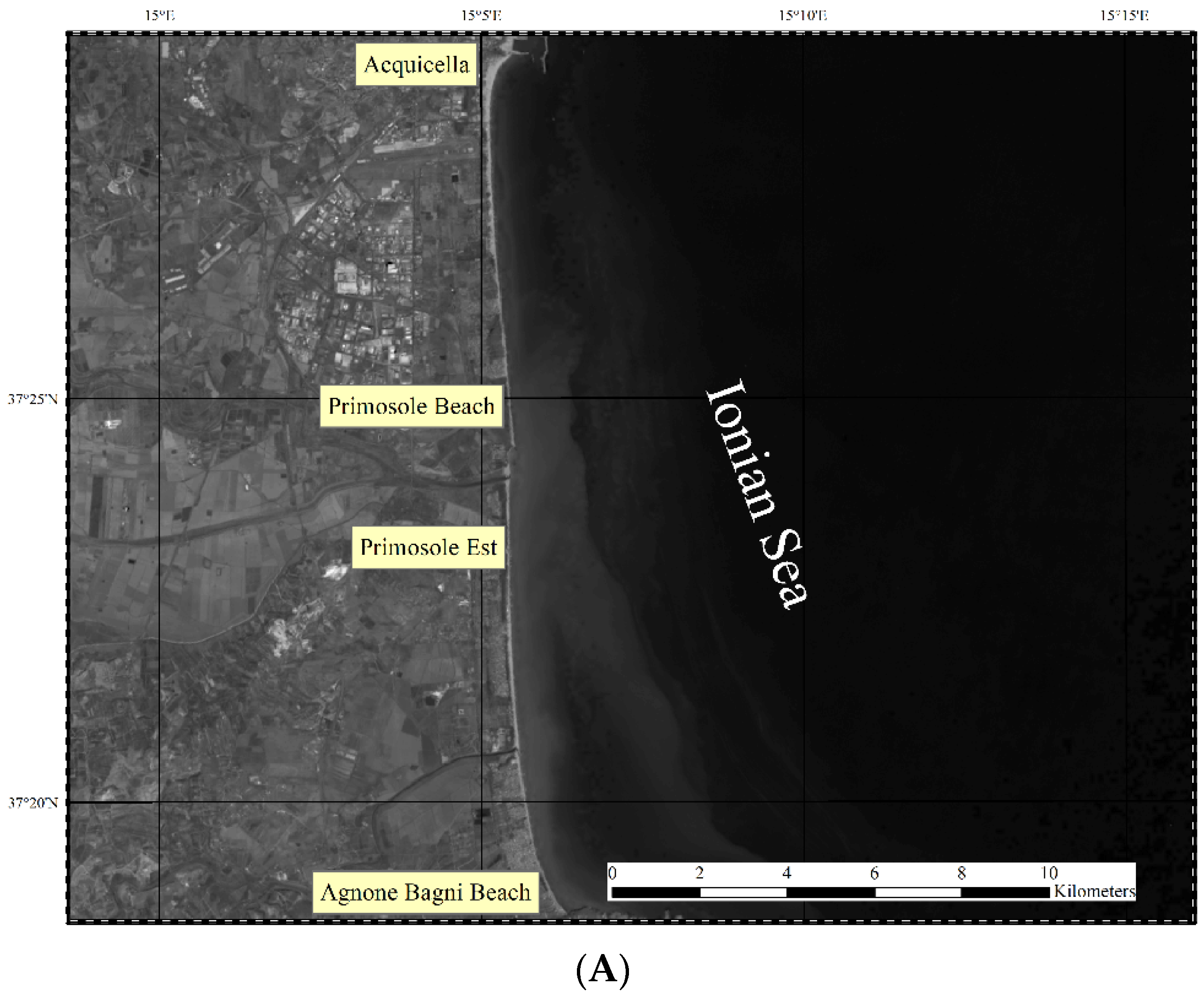
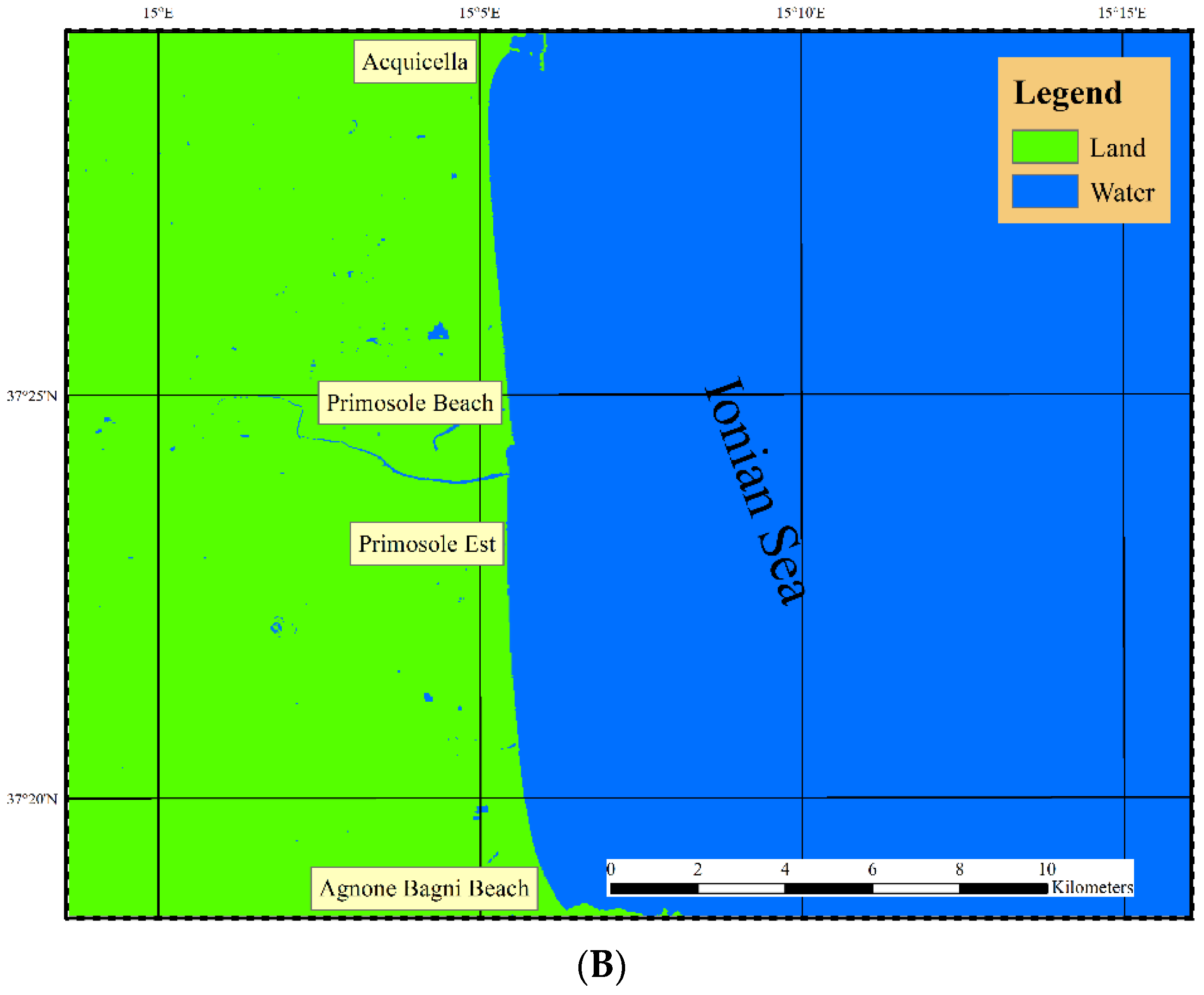


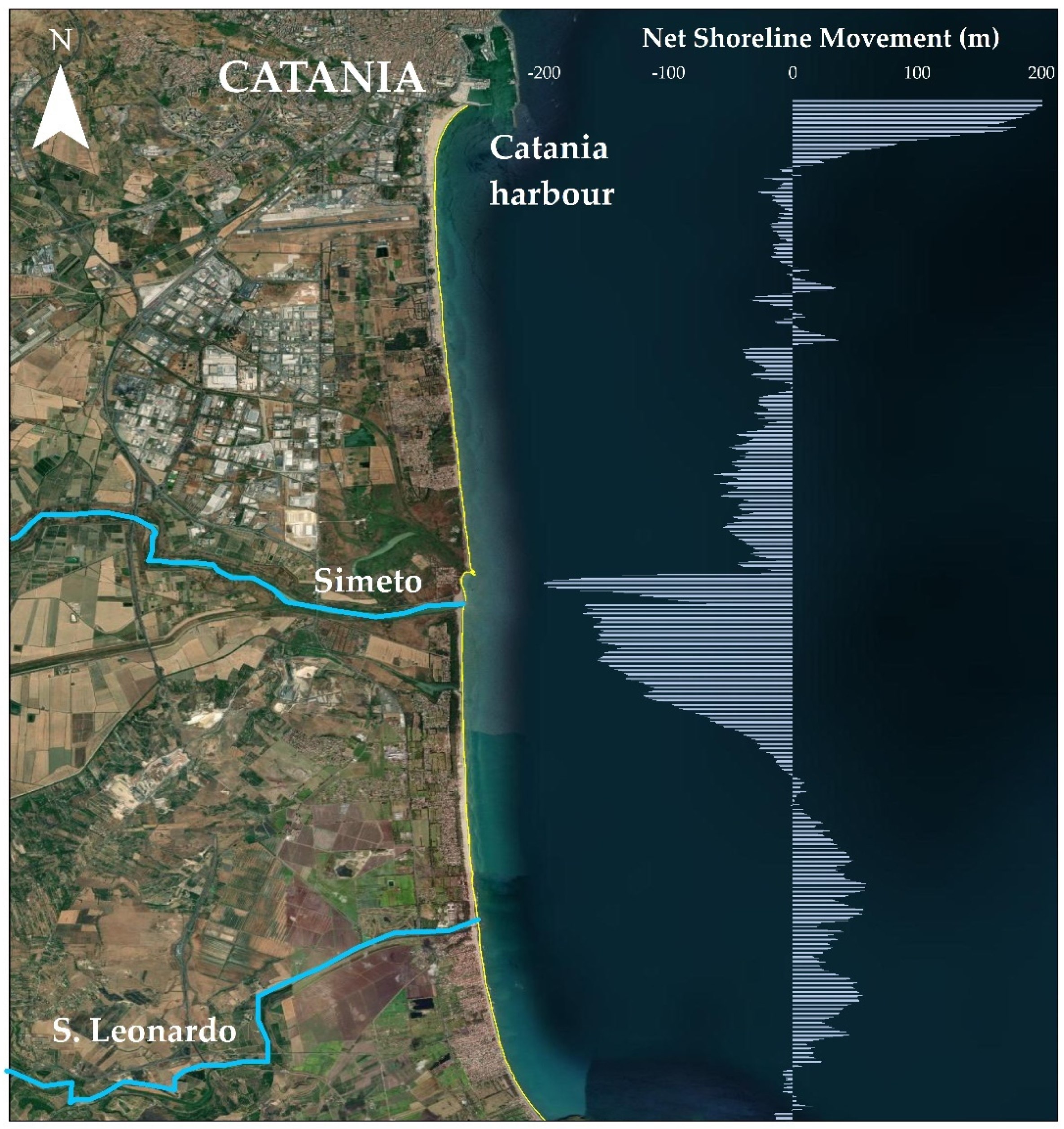
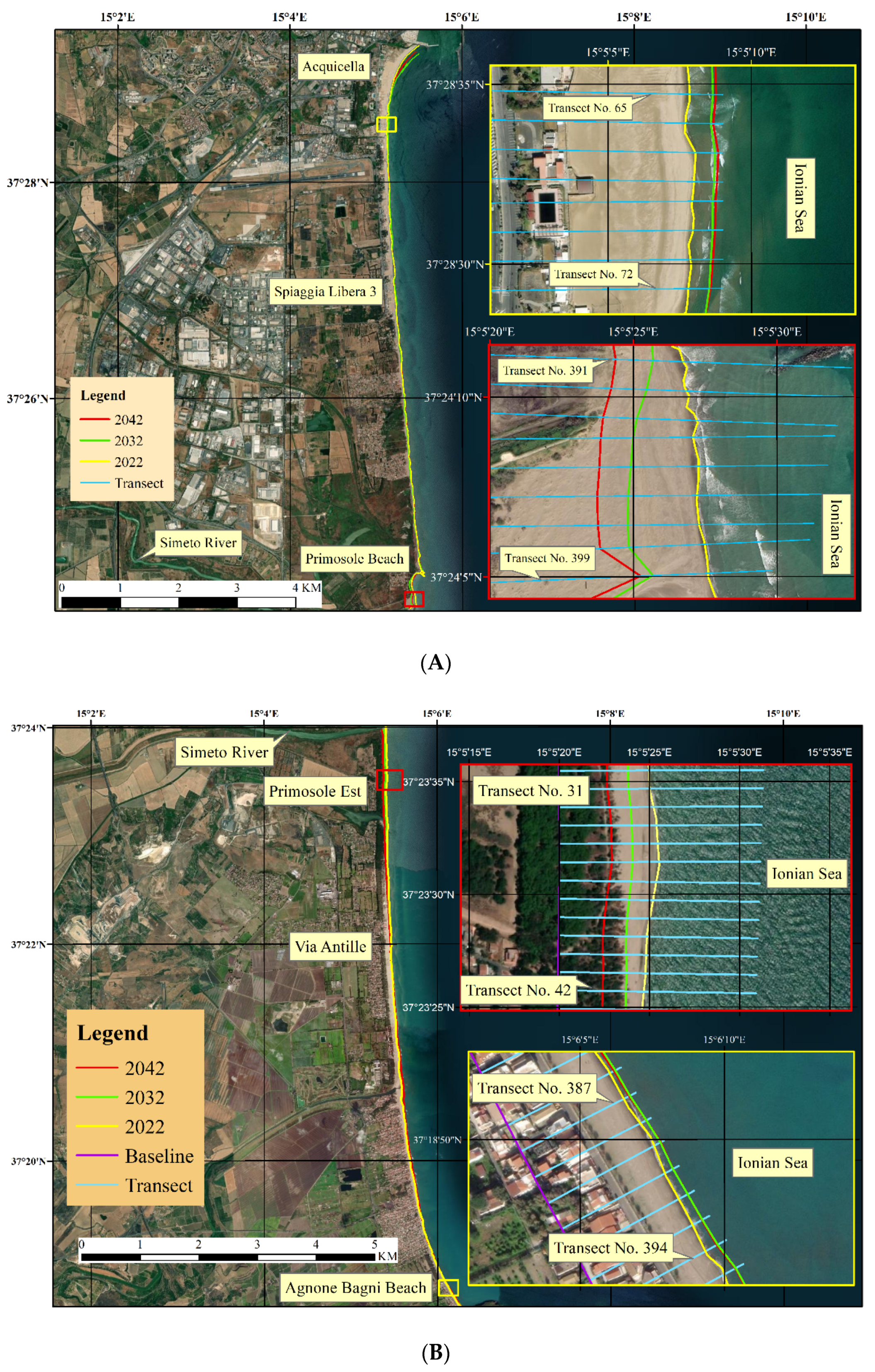

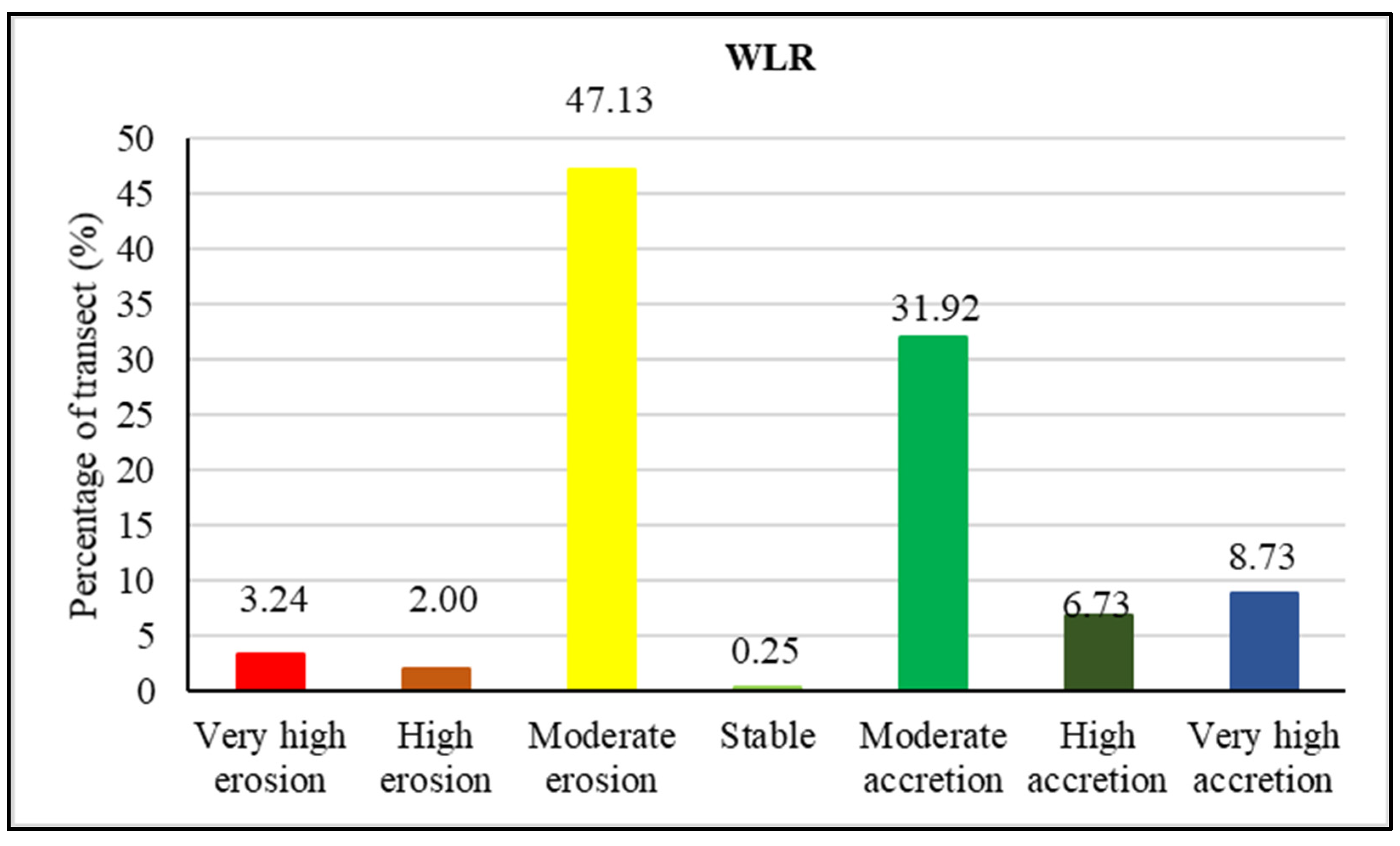
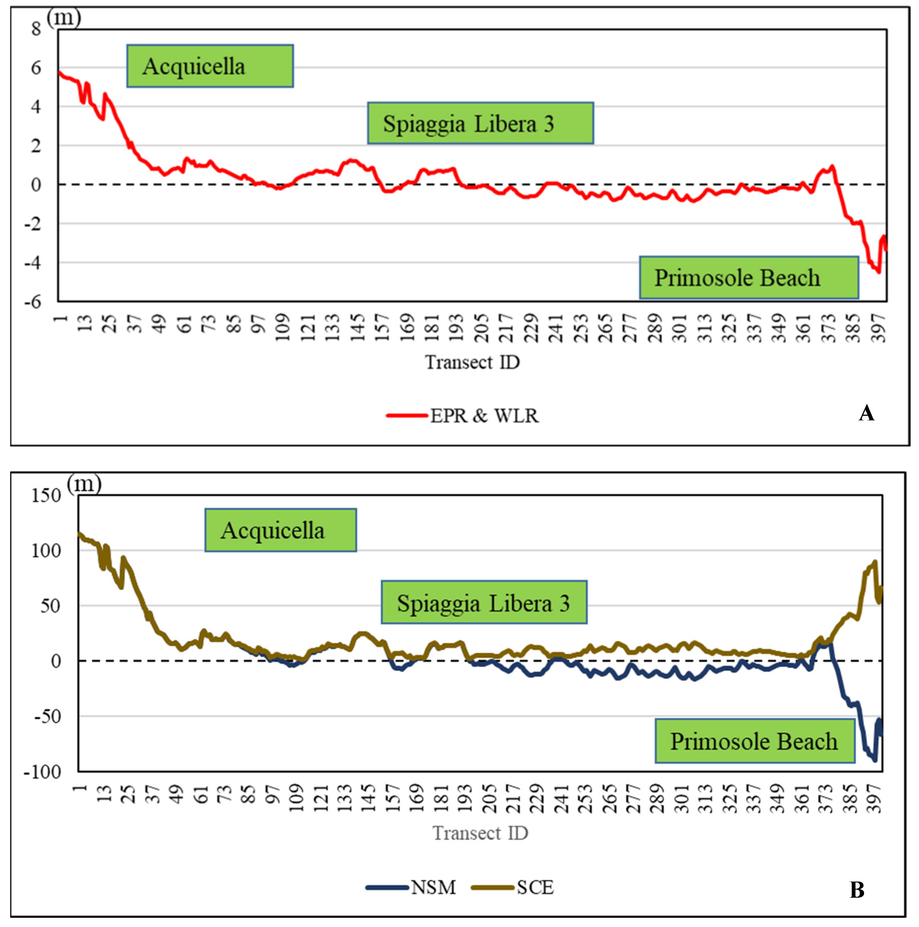
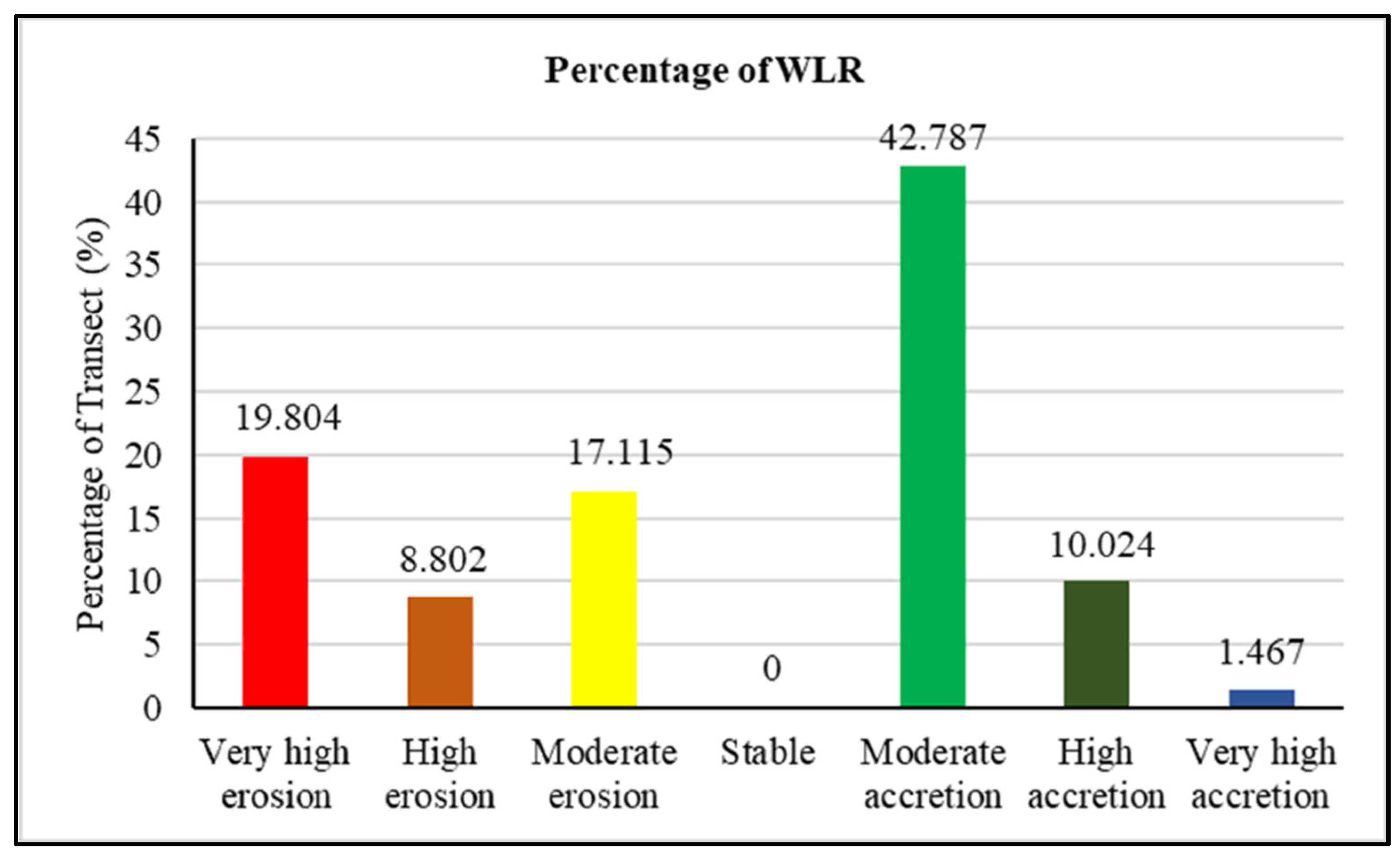


| Satellite | Resolution (m) | Year | Sensors | No. of Bands | Current Status | Green Band | NIR | RT |
|---|---|---|---|---|---|---|---|---|
| Landsat 1–5 | 60 | 1972 1981 1991 | MSS | 4 | Ended in 1992 | Band 4 for Landsat 1–3 MSS. Band 1 for Landsat 4 and 5 MSS. | Band 6 and 7 for Landsat 1–3 MSS. Band 3 and 4 for Landsat 4–5 MSS. | 18 |
| Landsat 4–5 | 30 | 1991 2001 2011 | TM | 7 | Ended in 2013 | Band 2 | Band 4 | 16 |
| Landsat 7 | 15 | 2001 2011 2021 | ETM + | 8 | Operational | Band 2 | Band 4 | 16 |
| Landsat 8–9 | 30 | 2021 | OLI TIRS | 11 | Operational | Band 3 | Band 5 | 16 |
| Sentinel–2 | 10 | 2021 2022 | MSI | 13 | Operational | Band 3 | Band 8 | 10 |
Publisher’s Note: MDPI stays neutral with regard to jurisdictional claims in published maps and institutional affiliations. |
© 2022 by the authors. Licensee MDPI, Basel, Switzerland. This article is an open access article distributed under the terms and conditions of the Creative Commons Attribution (CC BY) license (https://creativecommons.org/licenses/by/4.0/).
Share and Cite
Laksono, F.A.T.; Borzì, L.; Distefano, S.; Di Stefano, A.; Kovács, J. Shoreline Prediction Modelling as a Base Tool for Coastal Management: The Catania Plain Case Study (Italy). J. Mar. Sci. Eng. 2022, 10, 1988. https://doi.org/10.3390/jmse10121988
Laksono FAT, Borzì L, Distefano S, Di Stefano A, Kovács J. Shoreline Prediction Modelling as a Base Tool for Coastal Management: The Catania Plain Case Study (Italy). Journal of Marine Science and Engineering. 2022; 10(12):1988. https://doi.org/10.3390/jmse10121988
Chicago/Turabian StyleLaksono, Fx Anjar Tri, Laura Borzì, Salvatore Distefano, Agata Di Stefano, and János Kovács. 2022. "Shoreline Prediction Modelling as a Base Tool for Coastal Management: The Catania Plain Case Study (Italy)" Journal of Marine Science and Engineering 10, no. 12: 1988. https://doi.org/10.3390/jmse10121988
APA StyleLaksono, F. A. T., Borzì, L., Distefano, S., Di Stefano, A., & Kovács, J. (2022). Shoreline Prediction Modelling as a Base Tool for Coastal Management: The Catania Plain Case Study (Italy). Journal of Marine Science and Engineering, 10(12), 1988. https://doi.org/10.3390/jmse10121988


