Review

Characteristics and Trends of Ocean Remote Sensing Research from 1990 to 2020: A Bibliometric Network Analysis and Its Implications

1
Northwest Institute of Eco-Environment and Resources, Chinese Academy of Sciences, Lanzhou 730000, China
2
College of Geography and Environment Science, Northwest Normal University, Lanzhou 730070, China
*
Author to whom correspondence should be addressed.
J. Mar. Sci. Eng. 2022, 10(3), 373; https://doi.org/10.3390/jmse10030373
Submission received: 12 December 2021 / Revised: 25 February 2022 / Accepted: 2 March 2022 / Published: 6 March 2022
(This article belongs to the Special Issue Marine Environment Monitoring)

Abstract

:
The ocean is of great significance in the climate system, global resources and strategic decision making. With the continuous improvement in remote sensing technology, ocean remote sensing research has increasingly become an important topic for resource development and environmental protection. This paper uses bibliometric analysis method and VOSviewer visual software to conduct analysis. The analysis focuses on the period from 1990 to 2020. The analysis results show that articles have been steadily increasing over the past two decades. Scholars and researchers form the United States, China and Europe (mainly Western European countries), as well as NASA, Chinese Academy of Sciences and NOAA have bigger influence in this field to some extent. Among them, the United States and NASA holds the core leading position. Moreover, global cooperation in this field presents certain characteristics of geographical distribution. This study also reveals journals that include the most publications and subject categories that are highly relevant to related fields. Cluster analysis shows that remote sensing, ocean color, MODIS (or Moderate Resolution Imaging Spectroradiometer), chlorophy, sea ice and climate change are main research hotspots. In addition, in the context of climate warming, researchers have improved monitoring technology for remote sensing to warn and protect ocean ecosystems in hotspots (the Arctic and Antarctica). The valuable results obtained from this study will help academic professionals keep informed of the latest developments and identify future research directions in the field related to ocean remote sensing.

1. Introduction

The ocean, which accounts for 71% of the Earth’s surface area, is one of the three major ecosystems in the world with rich service functions. It plays a vital role in regulating the global climate, biogeochemical cycle, resource storage, protecting biodiversity and supporting Earth’s life [1,2]. The ocean can provide irreplaceable services for terrestrial ecosystems, which is directly related to the well-being of all mankind [3,4]. However, the ocean is suffering from the severe impacts of mixed factors such as climate change and anthropopressure. Furthermore, excessive interference poses a serious threat to the function of marine ecosystem [5,6]. As a macro-observation method, remote sensing has incomparable advantages over traditional observation in many aspects [7,8,9]. It plays an important role in monitoring the dynamic change of hot areas in marine research, marine ecology, environmental protection and resource development [10,11,12,13,14,15].
Ocean remote sensing was introduced during the Second World War [16]. It was once used in strategic decision making during the war, transferred technology towards ocean protection and effort to build a more sustainable economic model [17]. It uses sensors to make a long-distance and non-contact observation of the ocean in order to obtain images and data of marine landscapes and marine elements. The strength of ocean remote sensing lies in large coverage, high efficiency and multi-band imaging. It can quickly and effectively detect the temporal and spatial variation of various physical parameters on the ocean surface. Its earliest development is the use of remote sensing technology in estuarine, coastal mapping and offshore bathymetry. Since then, the application of ocean remote sensing technology has made new progress in the research of ocean internal waves, mesoscale eddies, ocean tide, polar sea ice observation, air–sea interaction, etc. [18]. At present, remote sensing technology has been applied in all aspects of various branches of oceanography. With the deepening of marine research, it has entered a new stage of development and has gradually become a new growth engine of the intersection of marine and remote sensing.
Although many scholars have made contributions to the field of ocean remote sensing [19,20,21,22], few relevant studies have conducted a comprehensive review and investigation on this research topic. The existing research mainly focuses on specific scientific research, such as sea–air interactions, deep learning models or ocean tides and polar sea ice observations, with little bibliometric analysis on the application of remote sensing in marine research [23,24,25,26,27]. Therefore, in order to effectively explore this cross-domain and emerging trend, it is urgent to analyze the development, hot spots and trend of this topic in a more systematic and comprehensive way.
Since the famous information scientist Alan Pritchard officially coined the word Bibliometrics in 1969 [28,29], it has developed rapidly, along with improved theories, methods and means. With the rapid development of computer and information technology, bibliometric methods and theories are increasingly applied to describe, evaluate and predict the status quo and development trend of science and technology. Bibliometrics takes the external characteristics of literature as the research object and uses statistical measurement methods to study the distribution structure, quantitative relationship and changing law of literature [30]. It is featured by objectivity, quantification and easy comparison. It is a common approach in the study of research evaluation for comparing evaluation indicators or highlighting comprehensive capacity of scientific research [31,32,33,34,35,36]. It can be seen that in the era of big data, bibliometrics is very suitable for macrostatistical analysis of a certain scientific research field [37,38,39,40,41,42,43,44,45]. Researchers tend to focus on a specific field of one discipline and conduct qualitative research on it, which reflects expertise. In contrast, those undertaking information gathering can use bibliometric methods and tools (conduct quantitative research on a lot of scientific outcomes) to elaborate on the overall features of the discipline (such as the research level of both domestic and overseas institutions, field layout and future development trends) as a whole.
In this article, the bibliometric approach and visual analysis software are adopted to analyze the overall development of international ocean remote sensing research. The study mainly aims to (1) summarize differences among annual publication output, source journals and subject distribution characteristics; (2) analyze research outputs and international cooperation both at the national and global level; (3) based on the analysis of hot key words, reveal the basic law of ocean remote sensing research. The study helps to understand the overall development of global marine remote sensing research from a macro perspective and uses the objective data results to make decisions for researchers and managers.

2. Methodology and Data Gathering

In the research, an array of scientometrics analysis methods and drawing tool of scientific knowledge map are employed, including co-authorship, co-occurrence analysis, cluster analysis and thematic evolution analysis. The study analyzes the co-authorship between countries and institutions, which is considered a cooperative relationship if they appear in the same paper. In the case of the co-authorship analysis, the strength of the links between countries and institutions represents the number of publications co-authored by them. Co-occurrence analysis is utilized to analyze the occurrence number of a group of words in the research literature, namely, words appearing simultaneously in a literature that are somewhat related [46]. In the case of the co-occurrence analysis, the link strength between keywords indicates the number of publications in which two keywords appear simultaneously. For this study, co-occurrence analysis is conducted for keywords, countries, institutions and subjects to obtain research hotspots, institutional cooperation and key topics in this research. Cluster analysis is based on the similarity of objects, with collections of physical or abstract objects grouped into multiple clusters composed of similar objects for analysis [47].
VOSviewer is also applied to map the connection among papers to help users narrow the cognitive gaps and identify key information and future trends of a research field. Invented by Van Eck and Waltman in the Netherlands, VOSviewer is a freely-availabletext mining software for generating bibliometric maps and analyzing trends in the scientific literature [48]. It combines theories of graphics and information visualization with the word frequency co-occurrence technology in traditional bibliometric, with unique advantages in visual display and clustering. VOSviewer uses a clustering algorithm to cluster the literature network, which is similar to the network clustering method of Modularity [45,46,47,48]. Its formula is as follows:
V ( c 1 , c n ) = 1 2 m i < j δ ( c i , c j ) ω i j ( c i j γ c i c j 2 m ) ω i j = 2 m c i c j
where ci is the cluster of element I, and γ is the resolution of clustering. By adjusting its size, different resolution clustering can be obtained. A larger γ means that the more clusters are obtained, the finer the classification will be [47]. In VOSviewer, the number of clusters is determined by the option “choose threshold”. In the co-authorship analysis, the threshold means the lowest number of documents of a country or an institution. In the co-occurrence analysis, the threshold means the lowest value of occurrences of a keyword. The threshold is chosen based on actual needs.
The bibliometric indicators and data used in this paper include a number of publications, subject categories, source journals, countries and institutions, all of which were obtained directly from the core collection database of Web of Science. It is a large, comprehensive, multidisciplinary database for science citation indexing that contains literatures and citations of various important core journals over the past 100 years. Moreover, it also serves as the database providing the longest citation backtracking data at present. It covers a wide range of subjects, including the most influential scientific and technological journals in various fields. It is not only the most commonly used data platform for scholars to obtain first-class academic literature, but it is also the most authoritative data source for information analysis of scientific research.
The following keywords are used to search the current research: TS = (“ocean” OR “oceans” OR “blue sea” OR “seas” OR “sea” OR “marine” OR “sea coast” OR “coast”) and TS = (“remote sensing” OR “remote sense”). The language is set as “English”, the literature type as “Article” and the time span of articles as “1990–2020”, for there are fewer publications earlier than 1990 in the data records. In total, 12,914 were obtained in the initial search (the data were last updated on 28 May 2021). Since the high-quality data results are mostly determined by the accuracy and integrity of the data, Thomson Data Analyzer (TDA) can perform flexible thesaurus customization and data cleaning functions [44]. Furthermore, the irrelevant articles were eliminated by artificially reading titles, abstracts and the lack of key fields (such as country and author). Finally, a total of 11,777 records were retrieved as the data for this analysis. In addition, we introduced ArcGIS into the field for the retrieval and discovery of geographic information and used a map to visualize the distribution of publications among countries, which can provide more insights into the research pattern across spatial scales.

3. Results

3.1. The Characteristics Analysis of Publication Outputs

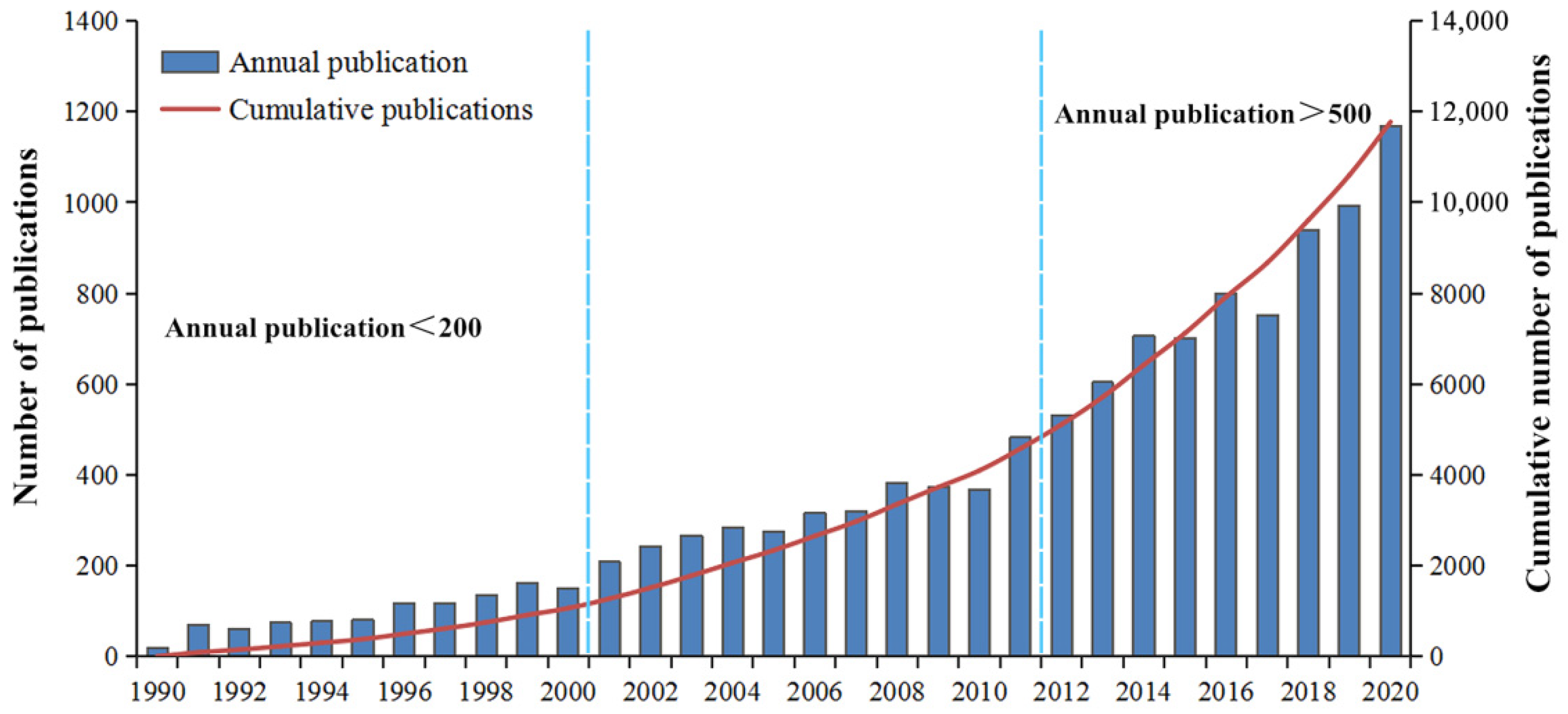
3.1.1. General Trends of Publication Outputs

As ocean remote sensing research started relatively early, the related literature was first published in 1969 [49,50,51]. However, large-scale research was conducted late, as the annual distribution of publications from 1990 to 2020 show in Figure 1. In general, the number of publications has risen and fallen, with slight fluctuations between individual years. Over the long term, the number of publications continues to increase. According to the cumulative number, the development of publications can be divided into three stages. The first stage is from 1990 to 2000, during which the number of annual publications was less than 200. This period witnessed relatively slow growth. The second stage is from 2001 to 2011, which has witnessed a steady increase, with the number of annual publications staying between 200 and 500. The last stage is from 2012 to 2020, during which the number of publications increased rapidly, with an annual publication of more than 500 studies. Furthermore, in 2020, 1169 articles were included in the database.

3.1.2. Distribution of Publications in Major Journals

Overall, journal analysis was conducted to analyze the influence of different publications. By analyzing the distribution of journals in the database, Table 1 presents the top 15 journals with the most frequent citations in this field. A total of 4815 articles have been published in these journals in the research field of remote sensing, covering 40.90% of the total publications. Moreover, the IFs are relatively high, with the highest exceeding 10.0. Therefore, it can be seen that the overall quality of papers is high, and relevant research is relatively mature. Among them, Remote Sensing is the most popular journal (785), followed by Remote Sensing of Environment (681), IEEE Transactions on Geoscience and Remote Sensing (667), the Journal of Geophysical Research: Oceans (508) and the International Journal of Remote Sensing (476). The number of citations of a journal reflects its influence [52]. The top-ranked journal by citation frequency is Remote Sensing of Environment (30,303), followed by IEEE Transactions on Geoscience and Remote Sensing (29,191), the Journal of Geophysical Research: Oceans (20,201), the Journal of Geophysical Research: Atmospheres (17,730) and Applied Optics (10,089), with the top 5 journals accounting for over 66% of the citations of the top 15 journals.

3.2. Research Influence and Cooperation Analysis

3.2.1. Influence Distribution and Cooperation among Major Countries

To date, 113 countries contributed to this field. The top 30 countries with the highest number of publications in the ocean remote sensing research for the whole study period are presented in Figure 2. The United States tops the list with the largest number of publications (2558) and a share of 21.72%. China published 1829 papers (15.53%), ranking second. Other top ranked countries are Germany (5.12%), France (4.91%), Italy (4.75%), the United Kingdom (4.15%), Australia (4.08%), India (3.99%), Russia (2.67%) and Canada (2.60%). Moreover, the number of publications in these countries exceeds 300, and the United States published 8 times more studies than Canada. In order to better understand the influence of each country in the research field, the author also found that the total citations of papers in major countries (>200) is basically proportional to the number of publications, with exception to Germany and Italy. In this regard, the United States, China and France are the most cited, with more than 20,000, among which the United States is far ahead. The United Kingdom, Germany, Italy and Australia are in the second tier, with more than 10,000 each. In terms of citations per paper, the United States and France rank highest (38.7), while Egypt, Russia, China and India are relatively low (<15).
The international cooperation and exchange of scientific research is not only an inevitable trend of scientific development but also an important way to improve the level and influence of the research. The cooperation network among productive countries based on the VOSviewer software for the construction of scientific maps is presented in Figure 3, with each colored node representing a country, and the size of nodes revealing citations of these countries, while the thickness of lines among them indicating their collaborative relations and strength. According to Figure 3, the United States has the closest cooperation with other countries (a link strength of 2607), and its major partners are China (468), France (281), the United Kingdom (247), Canada (185) and Germany (184). The United Kingdom has relatively strong cooperation with the following countries (1360), the United States (247), Germany (117), France (116), Australia (94) and Italy (92). Following these countries, France (1255), Germany (1159) and China (1050) also have strong cooperation with other countries. It can be seen that the United States, the United Kingdom, France, Germany and China have become global cooperation centers in the field, all of which had an intermediary role and strong influence in collaborative networks, with technological advantages and research strength as main contributors.

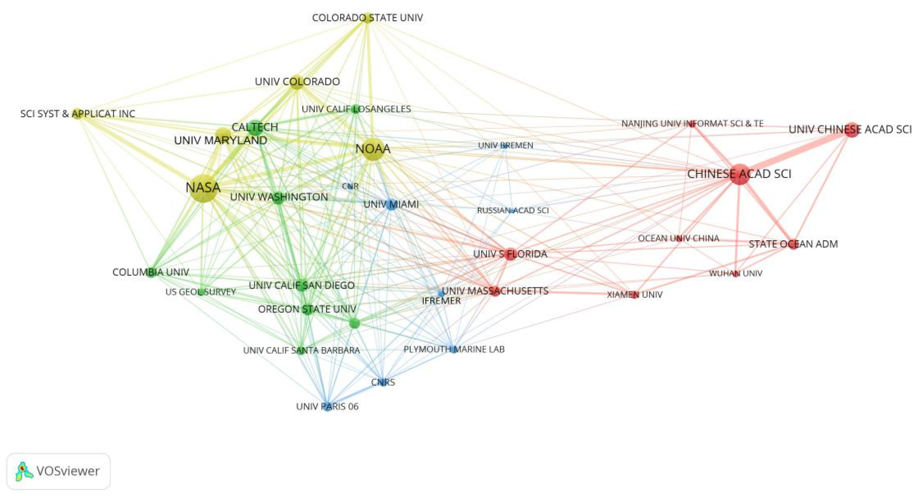
3.2.2. Influence Distribution and Cooperation among Core Institutions

The top 20 research institutions with the largest number of publications are listed in Table 2. Among them, NASA is the most productive institution, with 764 publications and accounting for 6.49% of the total. The Chinese Academy of Sciences ranks in second place with 702 publications and accounting for 5.96%, followed by NOAA and Caltech, all of which published over 300 publications. NASA also ranked first when it comes to the number of citations, followed by NOAA, Caltech, the University of Florida, the University of Maryland, the Chinese Academy of Sciences and the University of California San Diego, all of which have more than 9000 citations. Among the 20 institutions, it is noteworthy that 11 institutions are all located in the United States with absolute strength in the field, while there are 5 institutions in China, 2 in France and the other 2 are in the United Kingdom and Russia, respectively. As shown in Figure 4, there is a visualization of their cooperation over the last three decades. NASA (701), NOAA (507) and the Chinese Academy of Sciences (432) have the highest total link strength, indicating their pivotal influence in this field. The strongest collaborations are identified between Chinese Academy of Sciences and University of Chinese Academy of Sciences, as well as NASA and Science Systems and Applications, Inc. It can be seen that the cooperation among institutions mainly occurs within the same country or neighboring countries.

3.3. Research Hotspots Analysis

3.3.1. Characteristics of Subject Categories Distribution

According to WOS-defined subject categories, we present the top 14 subject categories in Table 3. It includes the number of articles accounting for more than 2.8% of the total number. The top-ranked category is remote sensing (30.81% of all publications, 3628), followed by environmental sciences (28.03%, 3301), imaging science and photographic technology (27.66%, 3257), geosciences and multidisciplinary (25.34%, 2984) and oceanography (20.50%, 2414). Other important disciplines include meteorology and atmospheric sciences, engineering, electrical and electronic and geophysics (>9.00%). In addition, judging from the citation frequency of papers in various disciplines, the most relevant fields are geochemistry and geophysics (36.22), followed by meteorology and atmospheric sciences (35.12) and ecology (33.85). These top categories and citations demonstrate the high priority of geological, atmospheric and ecological issues, which draw increasing attention from the scientific community.

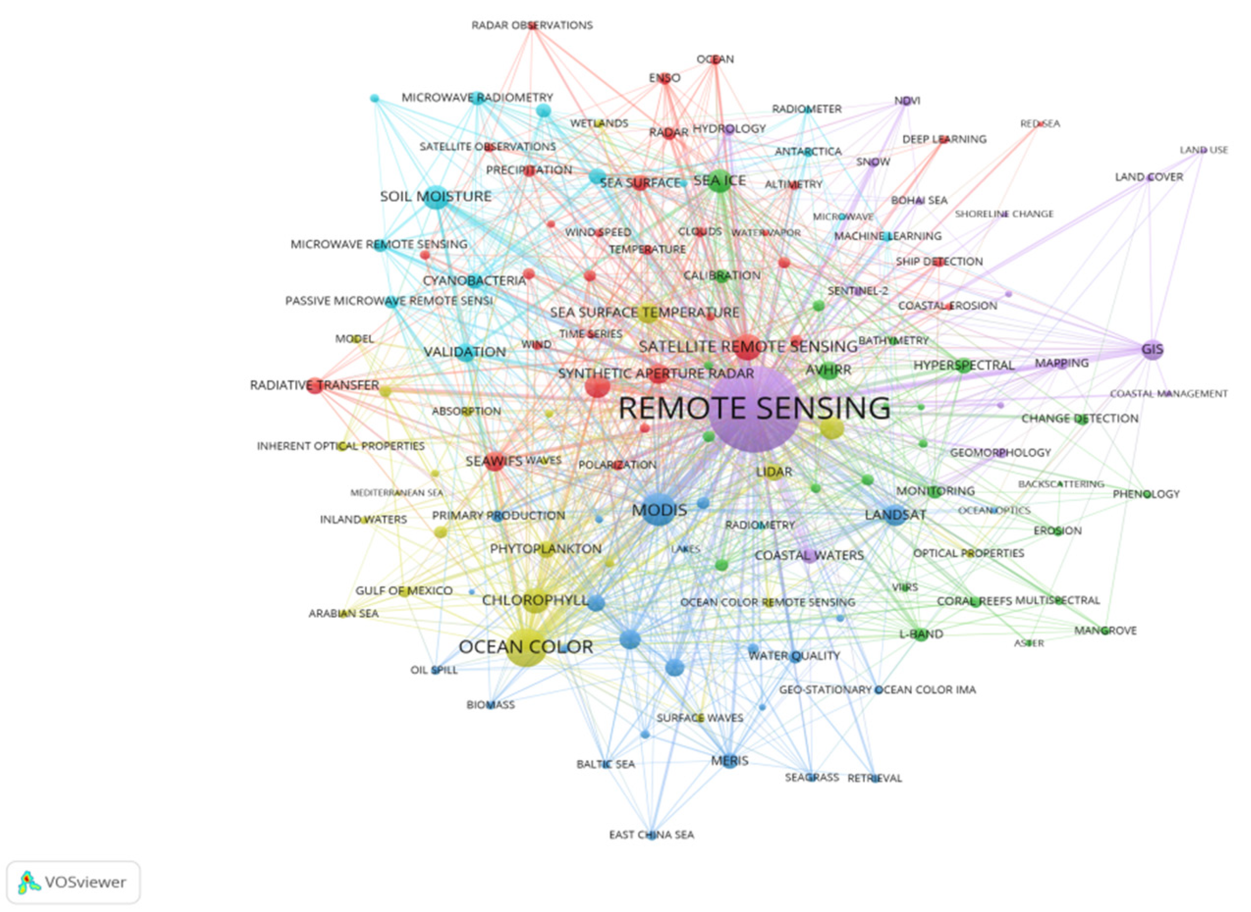
3.3.2. Analysis of Co-Occurrence Keywords

Keywords are abstracts of an article topic, which can summarize the core content of the paper in a simple, direct and comprehensive way [53,54]. As such, since co-occurrence keywords in different articles imply the research status, hot spots and future development trend of a field [55], it is necessary to systematically analyze keywords in relevant studies. According to the Figure 5, which is used to identify the research front in terms of the topic, each node represents a keyword, whose size is proportional to the co-occurrence frequency. As it shows, the larger the node is, the higher the word frequency becomes. The line thickness between the two nodes represents the degree of connection. The network of co-occurring keywords consists of 138 nodes and 2037 links, and the frequency of the connection among them is 9282. Highly frequent keywords reflect hot topics of the research. It can be seen that “Remote Sensing” (4513), “Ocean Color” (889), “MODIS” (680), “Satellite Remote Sensing” (436), “Chlorophyll” (390), “Soil Moisture” (361), “Sea Ice” (353), “Arctic” (351), “Climate Change” (315) and “Landsat” (290) are the most frequent research topics.
Cluster analysis groups similar objects together and determine clusters that represent related study areas [56]. By clustering the network of keywords co-occurrence, the research theme of ocean remote sensing is divided into six colored clusters, Cluster #1, Cluster #2, Cluster #3, Cluster #4, Cluster #5 and Cluster #6, corresponding to different colors, as shown in Figure 5 and Table 4. The cluster scale in Table 4 represents the number of keywords in each cluster, reflecting the importance of the corresponding cluster. In this analysis, the minimum number of occurrences of a keyword is 30 times in all publications. Cluster #1 (the red cluster) has the highest number of keywords (32). In addition to “Satellite Remote Sensing”, other keywords in this cluster include “Arctic”, “SeaWiFS”, “Synthetic Aperture Radar”, “Radiative Transfer”, “Sea Surface”, “Rada” and “Precipitation”. Most keywords in this cluster are associated with the research of ocean monitoring that involves hyperspectral remote sensing satellite and radar. There are 25 keywords in Cluster #2 (the green cluster), among which “Sea Ice”, “AVHRR”, “Hyperspectral”, “L-Band”, “Calibration”, “Monitoring” and “Colored Dissolved Organic Matter” are the main related keywords, indicating that ocean remote sensing is used to accurately detect changes of sea ice and CDOM. The number of keywords in cluster #3 (the blue cluster) is also 25, which includes “MODIS”, “Landsat”, “Chlorophyll-A”, “Atmospheric Correction”, “Remote Sensing Reflectance”, “MERIS”, “Water Quality”, etc. These key words appear in the relevant research on the chlorophyll-A and atmospheric environment, as well as water quality. Cluster #4 (the yellow cluster), with 24 keywords, focusing on “Ocean Color”, “Chlorophyll”, “Climate Change”, “Sea Surface Temperature”, “Phytoplankton”, “Lidar”, “Upwelling”, etc. This cluster is related to the analysis of chlorophyll by ocean colour and Lidar. There are 16 keywords in Cluster #5 (the purple cluster), mainly including “Remote Sensing”, “GIS”, “Coastal Waters”, “Hydrology”, “Mapping”, “Geomorphology” and “NDVI”. This cluster has connections with keywords related to the study of geomorphology and mapping in which remote sensing and GIS analysis methods are used. There are also 16 keywords in Cluster #6 (the light blue cluster), among which the most frequently used one is “Soil Moisture”, followed by “Validation”, “Cyanobacteria”, “SMOS”, “Microwave Remote Sensing”, “Microwave Radiometry”, “Salinity”, “Passive Microwave Remote Sensing”, etc. This cluster is related to the detection analysis of soil moisture and salinity through microwave remote sensing.

3.3.3. Theme Evolution Visualization

The identification of the topic evolution path refers to the research that reveals the development context and evolution laws of the technical field through the tracking and analysis of the development, change trend and interaction among different topics in the time series of the research topic represented by words [57]. It can help researchers trace the development trend of specific areas, identify research hotspots and potential new knowledge growth points [58,59,60,61]. The evolution view of the keywords is presented in Figure 6.
Each circle represents a hot word, and its size indicates the frequency of the word. Keywords used in the early stage of the time series are presented on the left side, and vice versa. In addition to remote sensing, the evolution analysis of the top 31 hot words by frequency can be summarized in 3 hot research topics. The results show that hot research topics are distributed in the exploration of marine ecosystems by microwave remote sensing before 2012, and the main hotspots include “Chlorophyll”, “SeaWiFS”, “Microwave Remote Sensing”, “Microwave Radio”, “Primary Production”, “Synthetic Aperture Radar” and “Aerosol”. From 2012 to 2105, the hot research topic was remote sensing monitoring data to simulate the impact of climate change on the ocean, especially in the Arctic. The main hotspots include “Satellite Remote Sensing”, “Ocean Color”, “Sea Surface Temperature”, “Sea Ice”, “GIS”, “Climate Change”, “Phytoplankton”, “Upwelling”, “Monitoring”, “Ocean Remote Sensing”, “Bathymetry”, “Lidar”, “Sea Surface”, “Atmospheric Correction”, “Soil Moisture”, “Arctic”, “MERIS”, “Water Quality”, “Validation” and “Data Assimilation”. Since 2015, the hot research topic has evolved into the observation and study of changes in the marine environment by remote sensing. The main hotspots were “MODIS”, “Landsat”, “Chlorophyll-A” and “Remote Sensing Reflectance”.

4. Discussion

To develop the ocean, we must first understand the complex marine environment [62,63,64,65,66]. Since the successful launch of the first ocean remote sensing satellite SEASAT in 1978, after nearly half a century of development, the information on ocean remote sensing has grown rapidly, which has greatly promoted and enriched people’s understanding of the ocean [23,26,67]. In this paper, by retrieving and analyzing the extant literature on global ocean remote sensing research, we have provided a comprehensive and quantitative understanding of the overall international research forces, including countries and institutions, as well as main research directions.
From the perspective of the overall research period, the research in the field of ocean remote sensing started early, but it was not until the beginning of the 21st century that research in this field entered a period of rapid growth and became active rapidly. This shows that research activities in this field have attracted great attention from scholars in the past 20 years. The main reason is that the development of ocean remote sensing is driven by the environment in which marine economy prospered and ocean exploitation strategies arised in the early 21st century. To achieve the healthy and sustainable development of marine economy, we must rely on the development of high-tech, such as marine remote sensing, which are complementary [68,69,70,71].
Judging from the publications of major countries, countries engaged in the research of this field are dominated by the United States, China, Germany and France. Among them, the United States publishes the most articles, which is far ahead of other countries, and countries with the highest citations per paper are also mainly concentrated in the United States and Western European countries. It is worth noting that China’s total publications have jumped to the second place in the world, but its research outcomes have not attracted much attention, as high-quality papers are lacking, and their influence is still limited. Furthermore, among major institutions engaged in this field of research, NASA has published the most papers, followed by the Chinese Academy of Sciences, NOAA, etc. Among them, NASA has an obvious advantage in influence (the number of citations of articles is also ranked first), and the United States has the largest number of research institutions in the top 20 institutions, accounting for over 50%.
Moreover, the intensity of cooperation among countries shows that United States, China, the United Kingdom, France, Germany and other countries have a high degree of cooperation, indicating that these countries have become centers of international cooperation in this field. All the above confirm that these major countries and institutions have strong regional cooperation characteristics. In addition to the cooperation among major countries, countries tend to choose neighboring countries for cooperation. This is not only driven by the factor that facilitates cooperation among personnel, but also required by the study of the regional characteristics of the ocean as a key element [72,73,74].
Currently, the global ocean remote sensing research mainly focuses on “Remote Sensing”, “Environmental Sciences”, “Imaging Science and Photographic Technology”, “Geosciences and Multidisciplinary” and “Oceanography”. In addition, from the perspective of keyword frequency and clustering, and since 2015, main directions of global research in this field have shifted to “Remote Sensing”, “MODIS”, “Landsat”, “Chlorophyll” and “Remote Sensing Reflectance” [75,76,77,78,79]. This shows that against the overall background of climate change, researchers apply remote sensing technology to acquire data on sea surface and understand characteristics and process of physical change within the ocean, especially in hot spots around the world. Secondly, at present, it is necessary to continuously improve the three-dimensional and real-time observation network comprising of space, aircraft and seabed observations. In this network, space remote sensing is at the first layer, aircraft remote sensing is at the second layer while conventional water and seabed observation system is at the third layer.
Although this study provides a new perspective for the knowledge status and trends in the ocean remote sensing field, it still has some limitations. Firstly, we only use the Core Collection Database of the Web of Science, which may lead to incompleteness. Thus, future work should consider other platforms, such as Scopus, Google Scholar, etc. Secondly, due to language constraints, only English articles are selected in this analysis, some non-English papers are ignored. Thirdly, although the main research topics have been identified, the object, method and purpose of each work are still needed. Finally, when using VOSviewer software for visualization, the results presented may vary slightly due to some functional limitations of the software, a combination of various bibliometric analysis tools will be considered to analyze more in-depth information and continuously improve the accuracy of trend analysis in the future.

5. Conclusions

In this study, based on publications related to ocean remote sensing in the Web of Science database, authors systematically reviewed the publication characteristics, research themes and hotspots from 1990 to 2020 using bibliometric analysis method. The following conclusions can be drawn from this research.
The number of publications related to ocean remote sensing has significantly increased in the past two decades, especially during the period from 2012 to 2020, reflecting more concerns from various stakeholders and growing interests in this topic worldwide. Remote Sensing and Environmental Sciences become the largest subject categories. Remote Sensing of Environment and IEEE Transactions on Geoscience and Remote Sensing are the most important journals in this field. The United States and China are the top two most active countries in this field, both of which had the highest number of internationally collaborated articles and countries. NASA not only contributed the most publications in number but also became the most active institution in terms of citations. Based on the analysis of the frequency and clustering of keywords, the research topics related to ocean remote sensing were “Remote Sensing”, “Ocean Color”, “Chlorophy”, “Sea Ice”, “Arctic” and “Climate Change”. Furthermore, researchers have paid attention to the marine ecological environmental indicators’ quantification of monitoring status by remote sensing and analysis of its corresponding influencing factors.
In terms of future research direction, we conclude with understanding that should be paid attention to research on ocean remote sensing.
First, global ocean remote sensing research is in the ascendant. In the 1990s, the related research of ocean remote sensing has been advancing steadily, and the number of research results experienced the process of initial slow growth to rapid increase. It has increased several times in the last 10 years. On the premise that the global abnormal extreme climate continues to increase, it is necessary to continue to strengthen the related theoretical and application research of ocean remote sensing so as to play a more important role in the prediction of climate change in the future.
Second, in terms of comprehensive research influence, the United States and major European countries have strong research strength. Especially the United States and its scientific research institutions have published the largest number of articles and exerted the greatest influence. Although China and its scientific research institutions have ranked second in the world, which is directly related to the support of the country’s funding agencies for research in this field, their influence still has room for increase.
Third, international cooperation presents the characteristics of geographical cooperation. It can be seen from the international cooperation relations that in addition to cooperation between key countries and institutions, they prefer to choose neighboring countries or institutions for cooperation. The United States, China and some European countries have become regional centers of scientific research and exchange.
In the end, research on ocean remote sensing is dedicated to promoting the conservation of ecological environment. The mainstream research focused on exploring the periodic changes of marine ecosystems in hotspot areas (the Arctic and Antarctic) and monitoring and protecting the marine ecological environment by improving the performance of sensors for remote sensing in the context of climate warming. With these advantages, ocean remote sensing gained wide application prospect in marine environment observation, marine prediction, marine functional zoning and national rights and interests protection and so on.

Author Contributions

Q.W. designed the research, collected the data, data analysis, selection of the studies and wrote the first draft. J.W. participated in the design of the manuscript and reviewed the manuscript. M.X. participated in the data analysis and the systematic review. X.Z. processed and visualized the data. All authors have read and agreed to the published version of the manuscript.

Funding

This work was funded by the Literature and Information Capacity Building Special Project of Chinese Academy of Sciences (E0290001).

Institutional Review Board Statement

Not applicable.

Informed Consent Statement

Not applicable.

Data Availability Statement

Data sharing is not applicable. No new data were created or analysed in this study. Data sharing is not applicable to this article.

Acknowledgments

We wish to thank the anonymous reviewers for valuable comments on the manuscript.

Conflicts of Interest

The authors declare no conflict of interest.

References

  1. Fu, M.Z.; Zhang, C.H.; Wang, Z.L.; Jiang, M.J.; Wang, W. The Concept and identification of ecologically and biologically significant areas: Case study in the Huanghe river estuary. Haiyang Xuebao 2016, 38, 22–33. [Google Scholar]
  2. Wang, F.T.; Yu, R.C.; Li, J.X.; Mao, D.H.; Wang, C.Y.; Jia, M.M.; Liao, J.J.; Hu, Z.Y.; Gu, H.F.; Wei, Q.S.; et al. Big earth data in support of marine sustainable development. Bull. Chin. Acad. Sci. 2021, 36, 932–939. [Google Scholar]
  3. United Nations Environment Programme. Global Environment Outlook-GEO-6: Healthy Planet, Healthy People; Cambridge University Press: Cambridge, UK, 2019. [Google Scholar]
  4. Nellemann, C.; MacDevette, M.; Manders, T.; Eickhout, B.; Svihus, B.; Prins, A.G.; Kaltenborn, B.P. The Environmental Food Crisis: The environment’s Role in Averting Future Food Crises: A UNEP Rapid Response Assessment; UNEP: Nairobi, Kenya, 2009. [Google Scholar]
  5. Notz, D.; Stroeve, J. Observed Arctic sea-ice loss directly follows anthropogenic CO2 emission. Science 2016, 354, 747–750. [Google Scholar] [CrossRef] [PubMed] [Green Version]
  6. Cheung, W.W.L.; Reygondeau, G.; Frolicher, T.L. Large benefits to marine fisheries of meeting the 1.5 °C global warming target. Science 2016, 354, 1591–1594. [Google Scholar]
  7. Tiit, K.; John, H.; Claudia, G.; Chris, R.; Vittorio, E.B. Remote sensing of shallow waters—A 50 year retrospective and future directions. Remote Sens. Environ. 2020, 240, 111619. [Google Scholar]
  8. He, H.; Wei, W. Monitoring southwest drought of China using HJ-1A/B and Landsat remote sensing data. Proc. SPIE-Int. Soc. Opt. Eng. 2012, 8524, 10. [Google Scholar]
  9. Dong, L.N.; Tong, J.; Wang, C.Y. The Application of airborne remote sensing technology in land and resources. Appl. Mech. Mater. 2014, 644–650, 4360–4363. [Google Scholar] [CrossRef]
  10. Fink, P.; Harrod, C. Carbon and nitrogen stable isotopes reveal the use of pelagic resources by the invasive Ponto-Caspian mysid Limnomysis benedeni. Isot. Environ. Health Stud. 2013, 49, 312–317. [Google Scholar] [CrossRef]
  11. Catherine, K.; de Aline, M.V.; Nick, W.; Luke, L.; Henrique, O.S.; Milton, K.; Jeffrey, R.; Philipp, S.; John, C.; Rob, S.; et al. Performance of Landsat-8 and Sentinel-2 surface reflectance products for river remote sensing retrievals of chlorophyll-a and turbidity. Remote Sens. Environ. 2019, 224, 104–118. [Google Scholar]
  12. Konstantinos, T.; Dimitris, P.; Giuseppe, S.; Stefano, A. Floating marine litter detection algorithms and techniques using optical remote sensing data: A review. Mar. Pollut. Bull. 2021, 170, 112675. [Google Scholar]
  13. Zhao, H.B.; Gu, Y.C.; Fan, D.M.; Qiu, C.H.; Su, C.P.; Fang, W.H. Seasonal sea level variations in the Red Sea inferred from satellite altimetry, GRACE and temperature and salinity data. Acta Geod. Cartogr. Sin. 2019, 48, 1119–1128. [Google Scholar]
  14. Cui, T.W.; Ding, J.; Jia, F.; Mu, B.; Liu, R.J.; Xu, P.M.; Liu, J.Q.; Zhang, J. Out-of-Band 13. response for the Coastal Zone Imager (CZI) onboard China’s ocean color satellite HY-1C: Effect on the observation just above the sea surface. Sensors 2018, 18, 3067. [Google Scholar] [CrossRef] [PubMed] [Green Version]
  15. Chen, S.; Zhang, Z.H.; Ma, Y.; Shi, H.H.; Ma, A.Q.; Zheng, W.; Wang, Q.X.; Peng, Y.L.; Liu, J. Program for service evaluation of marine ecosystems in China waters. Adv. Earth Sci. 2006, 21, 1127–1133. [Google Scholar]
  16. Yun, C.X. Progress and prospect of marine remote sensing. Adv. Earth Sci. 1993, 8, 14–20. [Google Scholar]
  17. Sulich, A.; Sołoducho-Pelc, L.; Ferasso, M. Management Styles and Decision-Making: Pro-Ecological Strategy Approach. Sustainability 2021, 13, 1604. [Google Scholar] [CrossRef]
  18. Aerospace Information Research Institute, Chinese Academy of Sciences. Available online: http://www.irsa.ac.cn/kxcb/ygzs/201102/t20110222-_3074668.html (accessed on 30 August 2021).
  19. Guo, J.J.; Tsang, L.; Asher, W.; Ding, K.H.; Chen, C.T. Applications of dense media radiative transfer theory for passive microwave remote sensing of foam covered ocean. IEEE Trans. Geosci. Remote Sens. 2001, 39, 1019–1027. [Google Scholar] [CrossRef]
  20. Kleidman, R.G.; O’Neill, N.T.; Remer, L.A.; Kaufman, Y.J.; Eck, T.F.; Tanre, D.; Dubovik, O.; Holben, B.N. Comparison of moderate resolution Imaging spectroradiometer (MODIS) and aerosol robotic network (AERONET) remote-sensing retrievals of aerosol fine mode fraction over ocean. J. Geophys. Res. Atmos. 2005, 110, D22205. [Google Scholar] [CrossRef]
  21. Platt, T.; Sathyendranath, S. Ecological indicators for the pelagic zone of the ocean from remote sensing. Remote Sens. Environ. 2008, 112, 3426–3436. [Google Scholar] [CrossRef]
  22. Mao, Z.H.; Pan, D.L.; He, X.Q.; Chen, J.Y.; Tao, B.Y.; Chen, P.; Hao, Z.Z.; Bai, Y.; Zhu, Q.K.; Huang, H.Q. A unified algorithm for the atmospheric correction of satellite remote sensing data over land and ocean. Remote Sens. 2016, 8, 536. [Google Scholar] [CrossRef] [Green Version]
  23. Li, X.F.; Liu, B.; Zheng, G.; Ren, Y.B.; Zhang, S.S.; Liu, Y.J.; Gao, L.; Liu, Y.H.; Zhang, B.; Wang, F. Deep-learning-based information mining from ocean remote-sensing imagery. Natl. Sci. Rev. 2020, 7, 1584–1605. [Google Scholar] [CrossRef]
  24. Su, H.; Zhang, H.; Geng, X.; Qin, T.; Lu, W.; Yan, X.H. OPEN: A New Estimation of Global Ocean Heat Content for Upper 2000 Meters from Remote Sensing Data. Remote Sens. 2020, 12, 2294. [Google Scholar] [CrossRef]
  25. Lonneke, G.M.; Steef, P.; van Erik, S.; Neil, A.J.; Stuart, G. Concept for a hyperspectral remote sensing algorithm for floating marine macro plastics. Mar. Pollut. Bull. 2018, 126, 255–262. [Google Scholar]
  26. Salgado-Hernanz, P.M.; Racault, M.F.; Font-Muñoz, J.S.; Basterretxea, G. Trends in phytoplankton phenology in the Mediterranean Sea based on ocean-colour remote sensing. Remote Sens. Environ. 2019, 221, 50–64. [Google Scholar] [CrossRef]
  27. Loisel, H.; Stramski, D.; Dessailly, D.; Jamet, C.; Li, L.H.; Reynolds, R.A. An inverse model for estimating the optical absorption and backscattering coefficients of seawater from remote-sensing reflectance over a broad range of oceanic and coastal marine environments. J. Geophys. Res. Ocean. 2018, 123, 2141–2171. [Google Scholar] [CrossRef]
  28. Pritchard, A. Statistical bibliography or bibliometrics? J. Doc. 1969, 25, 348–349. [Google Scholar]
  29. Khudzari, J.M.; Kurian, J.; Tartakovsky, B.; Raghavan, G.S.V. Bibliometric analysis of global research trends on microbial fuel cells using Scopus database. Biochem. Eng. J. 2018, 136, 51–60. [Google Scholar] [CrossRef]
  30. Fahimnia, B.; Sarkis, J.; Davarzani, H. Green supply chain management: A review and bibliometric analysis. Int. J. Prod. Econ. 2015, 162, 101–114. [Google Scholar] [CrossRef]
  31. Aparicio, G.; Iturralde, T.; Maseda, A. Conceptual structure and perspectives on entrepreneurship education research: A bibliometric review. Eur. Res. Manag. Bus. Econ. 2019, 25, 105–113. [Google Scholar] [CrossRef]
  32. Leng, S.Y. The Geographical Sciences during 1986–2015: From the Classics to the Frontiers; The Commercial Press: Beijing, China, 2016. [Google Scholar]
  33. Merigo, J.M.; Yang, J.B. A bibliometric analysis of operations research and management science. Omega 2017, 73, 37–48. [Google Scholar] [CrossRef] [Green Version]
  34. Ospina-Mateus, H.; Quintana Jiménez, L.A.; Lopez-Valdes, F.J.; Salas-Navarro, K. Bibliometric analysis in motorcycle accident research: A global overview. Scientometrics 2019, 121, 793–815. [Google Scholar] [CrossRef]
  35. Zhang, J.D.; Jiang, L.P.; Liu, Z.H.; Li, Y.N.; Liu, K.L.; Fang, R.Y.; Li, H.H.; Qu, Z.G.; Liu, C.Y.; Li, F. A bibliometric and visual analysis of indoor occupation environmental health risks: Development, hotspots and trend directions. J. Clean. Prod. 2021, 300, 126824. [Google Scholar] [CrossRef]
  36. Cheng, Q.; Hu, W.; Bai, Z. Research trends of development on pearl bivalve mollusks based on a bibliometric network analysis in the past 25 Years. Front. Mar. Sci. 2021, 8, 657263. [Google Scholar] [CrossRef]
  37. Li, Y.X.; Wang, Y.; Rui, X.; Li, Y.; Wang, H.Z.; Zuo, J.; Tong, Y.D. Sources of atmospheric pollution: A bibliometric analysis. Scientometrics 2017, 112, 1025–1045. [Google Scholar] [CrossRef]
  38. Khalid, F.E.; Lim, Z.S.; Sabri, S.; Gomez-Fuentes, C.; Zulkharnain, A.; Ahmad, S.A. Bioremediation of diesel contaminated marine water by bacteria: A review and bibliometric analysis. J. Mar. Sci. Eng. 2021, 9, 155. [Google Scholar] [CrossRef]
  39. Choi, W.; Kim, J.; Lee, S.E.; Park, E. Smart home and internet of things: A bibliometic study. J. Clean. Prod. 2021, 301, 126908. [Google Scholar] [CrossRef]
  40. Martínez Vázquez, R.M.; Milán García, J.; De Pablo Valenciano, J. Analysis and Trends of global research on nautical, maritime and marine tourism. J. Mar. Sci. Eng. 2021, 9, 93. [Google Scholar] [CrossRef]
  41. Huang, Y.L.; Huang, Q.; Ali, S.; Zhai, X.; Bi, X.M.; Liu, R.Q. Rehabilitation using virtual reality technology: A bibliometric analysis, 1996-2015. Scientometrics 2016, 109, 1547–1559. [Google Scholar] [CrossRef]
  42. Luo, Z.; Miao, F.Z.; Hu, M.H.; Wang, Y.J. Research development on horseshoe crab: A 30-year bibliometric analysis. Front. Mar. Sci. 2020, 7, 41. [Google Scholar] [CrossRef]
  43. Hou, Y.L.; Wang, Q.W. A bibliometric study about energy, environment, and climate change. Environ. Sci. Pollut. Res. 2021, 28, 34187–34199. [Google Scholar] [CrossRef]
  44. Zeng, J.J.; Qu, J.S.; Ma, H.Q.; Gou, X.H. Characteristics and trends of household carbon emissions research from 1993 to 2019: A bibliometric analysis and its implications. J. Clean. Prod. 2021, 295, 126468. [Google Scholar] [CrossRef]
  45. Van, E.N.J.; Waltman, L. Software survey: VOSviewer, a computer program for bibliometric mapping. Scientometrics 2010, 84, 523–538. [Google Scholar] [CrossRef] [PubMed] [Green Version]
  46. Waltman, L.; Van, E.N.J.; Noyons, E. A unified approach to mapping and clustering of bibliometric networks. J. Informetr. 2010, 4, 629–635. [Google Scholar] [CrossRef] [Green Version]
  47. Duan, P.L.; Wang, Y.Q.; Yin, P. Remote Sensing Applications in Monitoring of Protected Areas: A bibliometric analysis. Remote Sens. 2020, 12, 772. [Google Scholar] [CrossRef] [Green Version]
  48. Zhao, X.B. A scientometric review of global BIM research: Analysis and visualization. Autom. Constr. 2017, 80, 37–47. [Google Scholar] [CrossRef]
  49. Stehling, K.R. Remote sensing of oceans. Atronautics Aeronaut. 1969, 7, 62–66. [Google Scholar]
  50. Buettner, K.J.; Katsaros, K.; Martin, L. Problems in remote sensing of sea surface qualities. Trans.-Am. Geophys. Union 1969, 50, 158. [Google Scholar]
  51. Vinograd, V.V.; Lazarenk, N.N. Some Results of use of doppler effect for remote sensing of sea waves. Oceanology-USSR 1969, 9, 414. [Google Scholar]
  52. Wang, B.J.; Zhang, Q.; Cui, F.Q. Scientific research on ecosystem services and human well-being: A bibliometric analysis. Ecol. Indic. 2021, 125, 107449. [Google Scholar] [CrossRef]
  53. Yin, X.X.; Zhang, G.P.; Li, X.F. A Research situation analysis of information sciences based on keywords statistics. J. Intell. 2009, 28, 1–4. [Google Scholar]
  54. Zhang, G.B.; Li, P.C.; Lu, W.; Cheng, Q.K. Research on keyword semantic function recognition based on multi-feature fusion. Libr. Inf. Serv. 2021, 65, 89–96. [Google Scholar]
  55. Liu, F.; Lin, A.; Wang, H.; Peng, Y.; Hong, S. Global research trends of geographical information system from 1961 to 2010: A bibliometric analysis. Scientometrics 2016, 106, 751–768. [Google Scholar] [CrossRef]
  56. Ouyang, W.; Wang, Y.D.; Lin, C.Y.; He, M.C.; Hao, F.H.; Liu, H.B.; Zhu, W.H. Heavy metal loss from agricultural watershed to aquatic system: A scientometrics review. Sci. Total Environ. 2018, 637, 208–220. [Google Scholar] [CrossRef] [PubMed]
  57. Ye, C.L.; Leng, F.H. Research on the improvement of subject topic evolution method based on co-word analysis. Inf. Stud. Theory Appl. 2012, 35, 79–82. [Google Scholar]
  58. Jiao, H.; Li, X.X. Identification of the knowledge evolution path in disciplinary field based on research topic: Taking the rough set of information science and library science as an example. Inf. Stud. Theory Appl. 2019, 42, 101–106. [Google Scholar]
  59. Wang, X.G.; Cheng, Q.K.; Lu, W. Analyzing evolution of research topics with NEViewer: A new method based on dynamic co-word networks. Scientometrics 2014, 101, 1253–1271. [Google Scholar] [CrossRef]
  60. Meng, S.; Xiong, D.P. Review and exploration of china subtropical climate change research based on scientometric analysis. Trop. Conserv. Sci. 2018, 11, 13. [Google Scholar] [CrossRef]
  61. Yang, W.T.; Zhang, J.T.; Ma, R.L. The prediction of infectious diseases: A bibliometric analysis. Int. J. Environ. Res. Public Health 2020, 17, 6218. [Google Scholar] [CrossRef]
  62. Edwards, M.; Richardson, A. Impact of climate change on marine pelagic phenology and trophic mismatch. Nature 2004, 430, 881–884. [Google Scholar] [CrossRef]
  63. Allison, L.P.; Paula, J.L.; Jim, R.E.; John, D.R. Climate change and distribution shifts in marine fishes. Science 2005, 308, 1912–1915. [Google Scholar]
  64. Moore, C.J. Synthetic polymers in the marine environment: A rapidly increasing, long-term threat. Environ. Res. 2008, 108, 131–139. [Google Scholar] [CrossRef]
  65. Hoegh-Guldberg, O.; Bruno, J.F. The impact of climate change on the world’s marine ecosystems. Science 2010, 328, 1523–1528. [Google Scholar] [CrossRef] [PubMed]
  66. Mcleod, E.; Chmura, G.L.; Bouillon, S.; Salm, R.; Björk, M.; Duarte, C.M.; Lovelock, C.E.; Schlesinger, W.H.; Silliman, B.R. A blueprint for blue carbon: Toward an improved understanding of the role of vegetated coastal habitats in sequestering CO2. Front. Ecol. Environ. 2011, 9, 552–560. [Google Scholar] [CrossRef] [Green Version]
  67. Muller-Karger, F.; Roffer, M.; Walker, N.; Oliver, M.; Schofield, O.; Abbott, M.; Graber, H.; Leben, R.; Goni, G. Satellite Remote Sensing in Support of an Integrated Ocean Observing System. IEEE Geosci. Remote Sens. Mag. 2013, 1, 8–18. [Google Scholar] [CrossRef]
  68. McCarthy, M.J.; Colna, K.E.; El-Mezayen, M.M.; Laureano-Rosario, A.E.; Mendez-Lazaro, P.; Otis, D.B.; Toro-Farmer, G.; Vega-Rodriguez, M.; Muller-Karger, F.E. Satellite remote sensing for coastal management: A review of successful applications. Environ. Manag. 2017, 60, 323–339. [Google Scholar] [CrossRef] [PubMed]
  69. Peng, B. Application research of marine remote sensing technology in the development of fishery economy. J. Coast. Res. 2019, 94, 783–787. [Google Scholar] [CrossRef]
  70. Zhang, X.; Deng, W.Q.; Jiang, Y.W. New insight into smart ocean: How is it different from digital ocean? Int. J. Digit. Earth 2019, 12, 1457–1464. [Google Scholar] [CrossRef]
  71. Kavanaugh, M.T.; Bell, T.; Catlett, D.; Cimino, M.A.; Doney, S.C.; Klajbor, W.; Messié, M.; Montes, E.; Muller-Karger, F.E.; Otis, D.; et al. Satellite remote sensing and the Marine Biodiversity Observation Network: Current science and future steps. Oceanography 2021, 34, 62–79. [Google Scholar] [CrossRef]
  72. Wang, J.P.; Qu, J.S.; Ma, J.Z. Analysis on development of global virtual water research based on bibliometric method. Adv. Earth Sci. 2018, 33, 653–663. [Google Scholar] [CrossRef]
  73. Barth, J.A.; Allen, S.E.; Dever, E.P.; Dewey, R.K.; Evans, W.; Feely, R.A.; Fisher, J.L.; Fram, J.P.; Hales, B.; Ianson, D.; et al. Better regional ocean observing through cross-national cooperation: A case study from the northeast Pacific. Front. Mar. Sci. 2019, 6, 1–13. [Google Scholar] [CrossRef]
  74. Wang, H.; Liu, N.; Zhang, Y.F.; Zhang, T.Y.; Ren, X.X. Risk prevention of marine and meteorological disasters along the “21st Century Maritime Silk Road”. Chin. Sci. Bull. 2020, 65, 453–462. [Google Scholar] [CrossRef]
  75. Huot, Y.; Antoine, D. Remote sensing reflectance anomalies in the ocean. Remote Sens. Environ. 2016, 184, 101–111. [Google Scholar] [CrossRef]
  76. Melin, F.; Sclep, G.; Jackson, A.; Sathyendranath, S. Uncertainty estimates of remote sensing reflectance derived from comparison of ocean color satellite data sets. Remote Sens. Environ. 2016, 177, 107–124. [Google Scholar] [CrossRef]
  77. Umbert, M.; Guimbard, S.; Ballabrera Poy, J.; Turiel, A. Synergy between Ocean Variables: Remotely Sensed Surface Temperature and Chlorophyll Concentration Coherence. Remote Sens. 2020, 12, 1153. [Google Scholar] [CrossRef] [Green Version]
  78. Wei, J.W.; Lee, Z.P.; Garcia, R.; Zoffoli, L.; Armstrong, R.A.; Shang, Z.H.; Sheldon, P.; Chen, R.F. An assessment of Landsat-8 atmospheric correction schemes and remote sensing reflectance products in coral reefs and coastal turbid waters. Remote Sens. Environ. 2018, 215, 18–32. [Google Scholar] [CrossRef]
  79. El Mahrad, B.; Newton, A.; Icely, J.D.; Kacimi, I.; Abalansa, S.; Snoussi, M. Contribution of remote sensing technologies to a holistic coastal and marine environmental management framework: A review. Remote Sens. 2020, 12, 2313. [Google Scholar] [CrossRef]
Figure 1. Time evolution of annual publication and cumulative number from 1990 to 2020.
Jmse 10 00373 g001
Figure 2. The distribution of the top 30 countries with publications in the area of ocean remote sensing research.
Jmse 10 00373 g002
Figure 3. The cooperation network of the productive countries.
Jmse 10 00373 g003
Figure 4. The cooperation network of the productive institutions.
Jmse 10 00373 g004
Figure 5. Co-occurrence analysis of keywords.
Jmse 10 00373 g005
Figure 6. The evolution of hot words.
Jmse 10 00373 g006
Table 1. Top 15 highly cited journals in the research field.
JournalCited FrequencyTotal PublicationsIF 1
Remote Sensing of Environment30,30368110.164
IEEE Transactions on Geoscience and Remote Sensing29,1916675.600
Journal of Geophysical Research: Oceans20,2015083.405
Journal of Geophysical Research: Atmospheres17,7302964.261
Applied Optics10,0891771.980
International Journal of Remote Sensing92584763.151
Remote Sensing83647854.848
Geophysical Research Letters81542214.720
Estuarine Coastal and Shelf Science52241722.929
Marine Ecology Progress Series48271012.824
Journal of Coastal Research40262810.854
Deep-sea Research Part II-Topical Studies in Oceanography3863932.732
Continental Shelf Research38351352.391
Atmospheric Chemistry and Physics36011036.133
Journal of Marine Systems34591192.542
1 IF are from Journal Citation Reports ™ 2020.
Table 2. Top 20 institutions based on total publications.
InstitutionCountryTotal
Publications
Percentage
%
CitationsCitation per Paper
NASAUnited States7646.4942,71255.9
Chinese Acad SciChina7025.96998514.2
NOAAUnited States5154.3721,89242.5
CaltechUnited States3312.8113,62641.2
State Ocean AdmChina2382.02325613.7
Univ S FloridaUnited States2311.9613,49558.4
Univ Chinese Acad SciChina2201.8720479.3
Univ ColoradoUnited States2091.77898743.0
Univ Calif San DiegoUnited States2061.75943245.8
Univ WashingtonUnited States2021.72887843.9
Univ MarylandUnited States1991.6911,92559.9
Russian Acad SciRussia1961.66303815.5
Plymouth Marine LabUnited Kingdom1821.55576531.7
Univ MiamiUnited States1591.35563735.5
Ocean Univ ChinaChina1561.32238815.3
Oregon State UnivUnited States1521.29674744.3
CNRSFrance1431.21840458.8
IFREMERFrance1291.10418432.4
Nanjing Uuiv Informat Sci & TechnolChina1170.99126010.8
Univ Calif Los AngelesUnited States1070.91373234.9
Table 3. Research topics involves the key subject areas.
RankSubject CategoriesNumber of PublicationsPercentage %Average Citations per Paper
1Remote Sensing362830.8125.44
2Environment Sciences330128.0322.27
3Imaging Science and Photographic Technology325727.6626.84
4Geosciences and Multidisciplinary298425.3420.94
5Oceanography241420.5027.92
6Meteorology and Atmospheric Sciences170614.4935.12
7Engineering, Electrical and Electronic11469.7332.42
8Geography Physical11359.6320.47
9Marine and Freshwater Biology10518.9225.35
10Geochemistry & Geophysics10458.8736.22
11Water Resources5354.5420.01
12Ecology5274.4733.85
13Optics4974.2230.39
14Engineering and Ocean3422.9018.84
Table 4. Six main clusters for high frequencies keywords.
ClusterKeywords (Total Link Strength)Items
1Satellite Remote Sensing (436), Arctic (351), SeaWiFS (252), Synthetic Aperture Radar (238), Radiative Transfer (178), Sea Surface (169), Radar (112), Precipitation (95), ENSO (89), Radar Remote Sensing (88), Vegetation (85), Oceanography (81), Polarization (71), Clouds (70), Ocean (68), Temperature (68), Ship Detection (67)32
2Sea Ice (353), AVHRR (215), Hyperspectral (162), L-Band (131), Calibration (119), Monitoring (117), Colored Dissolved Organic Matter (92), Classification(86), Data Assimilation (84), Change Detection (80), Ocean Remote Sensing (78), Coral Reefs (77), Satellite Imagery (57), Erosion (54), South China Sea (52), Bathymetry(48), Sea Level Rise(46) 25
3MODIS (680), Landsat (290), Chlorophyll-A (253), Atmospheric Correction (193), Remote Sensing Reflectance (187), MERIS (160), Water Quality (109), Primary Production (97), Random Forest (95), Suspended Particulate Matter (65), East China Sea (56), Baltic Sea (50), Retrieval (50), Neural Networks (49), Seagrass (48), Oil Spill (48), Geo-Stationary Ocean Color Imager (48)25
4Ocean Color (889), Chlorophyll (390), Climate Change (315), Sea Surface Temperature (277), Phytoplankton (182), Lidar (175), Upwelling (93), Gulf of Mexico (88), Scattering (76), Absorption (71), Inherent Optical Properties (66), Image Processing (64), Ocean Color Remote Sensing (54), Surface Waves (52), Arabian Sea (51), Wetlands (51), Optical Properties (49)24
5Remote Sensing (4513), GIS (266), Coastal Waters (136), Hydrology (87), Mapping (84), Geomorphology (71), NDVI (66), Sentinel-2 (61), Snow (54), Bohai Sea (41), Land Cover (34)16
6Soil Moisture (361), Validation (222), Cyanobacteria (166), SMOS (153), Microwave Remote Sensing (148), Microwave Radiometry (134), Salinity (120), Passive Microwave Remote Sensing (106), Machine Learning (64), Antarctica (62), Soil Moisture Active Passive (47)16
Publisher’s Note: MDPI stays neutral with regard to jurisdictional claims in published maps and institutional affiliations.

