Article

Controls of Submarine Canyons Connected to Shore during the LGM Sea-Level Rise: Examples from Taiwan

1
921 Earthquake Museum of Taiwan, National Museum of Natural Science, Taichung 413004, Taiwan
2
Institute of Oceanography, National Taiwan University, Taipei 10617, Taiwan
*
Author to whom correspondence should be addressed.
J. Mar. Sci. Eng. 2022, 10(4), 494; https://doi.org/10.3390/jmse10040494
Submission received: 2 March 2022 / Revised: 27 March 2022 / Accepted: 31 March 2022 / Published: 2 April 2022
(This article belongs to the Special Issue Coastline Evolution: From the Present to the Geological Perspective)

Abstract

:
During the Last Glacial Maximum (LGM) (~20,000 years ago), the sea level was lower than that during the present day by 120 m and the heads of most submarine canyons were close or connected to the coastline or shore, with enhanced terrestrial sediment input due to direct connections with river mouths. This was followed by a relative sea-level rise of 120 m and the migration of coastlines landward. As a result, the heads of some paleo-submarine canyons were no longer near river mouths or connected to the shore. Such canyons became inactive due to the lack of terrestrial sediment input. Only 4% of the world’s submarine canyons reach the coastline and remain active today. Among 13 submarine canyons off the shore of Taiwan, we identified seven (n = 7, 54%) that remain connected to the shore and are active during the present-day highstand. The purpose of this study is to determine the key controls of canyon heads that remain connected to the shore with terrestrial sediment input during the Holocene sea-level rise. As a result of high uplift rates, narrow coastal range, steep gradients, frequent earthquakes, and typhoon development in the Taiwan mountain belt, Taiwan has the highest-yield river and sediment supply. This has led to the transportation of large volumes of sediment to the surrounding deep seas. Narrow steep shelves and large sediment volumes associated with small mountain rivers are the main controls involved in the development of shore-connected canyons on the active Taiwan margin. Shore-connected canyons are present in greater numbers in the major earthquake zone on the eastern Taiwan margin. Frequent earthquake events are another significant factor in the occurrence of shore-connected canyons in the Taiwan region.

1. Introduction

Submarine canyons are major geomorphological features that develop on the continental shelf and upper slope, resulting from turbidity currents and mass failures during periods of relative sea-level fall [1]. The sequence stratigraphic model emphasizes sea level as a major control for off-shelf sediment transport and canyon incision [2]. Increased fluvial sediment supply to the canyon head is associated with sea-level lowstand, while decreased sediment supply is associated with sea-level highstand. When the sea level rises, most of the shelf is submerged and the distances between the river mouth and canyon head increase, with the cutting off fluvial sediment supply. Consequently, the intensity of canyon erosion with sediment flows generated by fluvial input decreases and canyons become inactive. However, under specific tectonic and climatic circumstances, river discharge can still reach canyons during sea-level rise [3,4,5]. For example, the Gioia and nearby Petrace canyons on the narrow SE Tyrrhenian margin (Central Mediterranean Sea) are characterized by their heads being in front of river mouths and very close to the coast, within a reduced distance of about 80–100 m from the coastline. Then, the heads of these two canyons have easy access to much sediment supplied by the aligned rivers, which are commonly associated with frequent flash-flood events [6]. It is noted that the heads of the Garrucha and Almanzora canyons indenting into the narrow shelf (<5 km) along the Palomares margin (southeastern Iberia) have direct riverine sediment input from adjacent rivers associated with high sediment discharges and episodic flash-flood events during the last sea-level rise [7].
Turbidity currents within a submarine canyon can be actively sustained during highstand if the river mouth and canyon head remain connected. Examples include the Congo (Zaire) Canyon [8,9], the Var Canyon off the French coast [10], the Messina Strait’s canyons [11,12], and the Kaoping Canyon off Taiwan [13,14,15,16]. However, the river–canyon connection is not the only factor involved. Monterey Canyon, in addition to canyons along the southern California Borderland, such as the La Jolla and Hueneme canyons, are capable of capturing longshore-transported sediments or shelf sediments and feeding them to their canyon heads [3,17]. Within canyons, bottom currents can be maintained during sea-level highstands in various ways, such as by the funneling of bottom nepheloid layers and capturing of suspended particles, such as in the Mienhua Canyon off North Taiwan [18,19,20].
The last glaciation took place about 20,000 years ago. Since then, the sea level has risen by 120 m, resulting in the landward migration of most present-day coastlines. Large shelf areas have become inundated and some canyons have become inactive [21]. If a canyon head is close to the shore, terrestrial sediment can be efficiently delivered and the canyon stays active. Bernhardt and Schwanghart (2021) [21] examined a total of 4633 canyon heads in the world’s oceans, of which 2765 (60%) were classified as slope canyons, 1702 (37%) as shelf-incising canyons, 798 (17%) as 120 m-contour canyons, and 183 (4%) as shore-connected canyons. Among them, 120 m-contour canyons occur along active and passive continental margins, while shore-connected canyons mostly occur along active margins. There are significantly more shore-connected canyons on active margins (n = 114) than on passive margins (n = 69). Bernhardt and Schwanghart (2021) [21] showed that shore-connected canyons tend to occur along continental margins, especially those with narrow and steep shelves, and that submarine canyon heads that remain connected to the shoreline are associated with regions of tectonic uplift and durable bedrock. Moreover, they identified 798 canyon heads at the 120 m depth contour, which is the Last Glacial Maximum (LGM) shoreline, in addition to 183 canyon heads connected to the shore, defined by a distance of within 6 km. Their work greatly contributes to the understanding of shore-connected canyons, especially their ability to erode headward at a pace maintained since the LGM. Chiang et al. (2020) [15] showed that shelf-incising canyons prevail (60%) along the tectonically active SW margins of Taiwan, which are characterized by a narrow shelf and abundant sediment supply. These canyons remain active at present. This relatively high number of shelf-incising canyons on the SW Taiwan margin was supported by Harris and Whiteway (2011) [22]. Taiwan is a unique area to investigate submarine canyon activity due to its many active shelf-incising canyons, in addition to its tectonics, sea-level changes, and climatic conditions.
Inspired by their study, we focus on the major controls of submarine canyons that have remained connected to the shore during the Holocene sea-level rise in this paper. Using the submarine canyons in the Taiwan region as examples, we determine the key controls of canyon heads that are connected to the shore with fluvial sediment input during the Holocene sea-level rise. In this study, newly acquired multibeam bathymetric data are examined, focusing on the relationships between the locations of heads and the distance to the shore of the submarine canyons off the shore of Taiwan. The objectives are: (1) to investigate the location of each canyon head with respect to the 120 m depth contour following the definition of shore-connected canyons of Bernhardt and Schwanghart (2021) [21] and to determine whether canyons are shore-connected; (2) to elucidate characteristic canyon types in relation to control factors on the active Taiwan margin since the LGM; and (3) to determine major controls of shore-connected canyons in the present sea-level highstand.

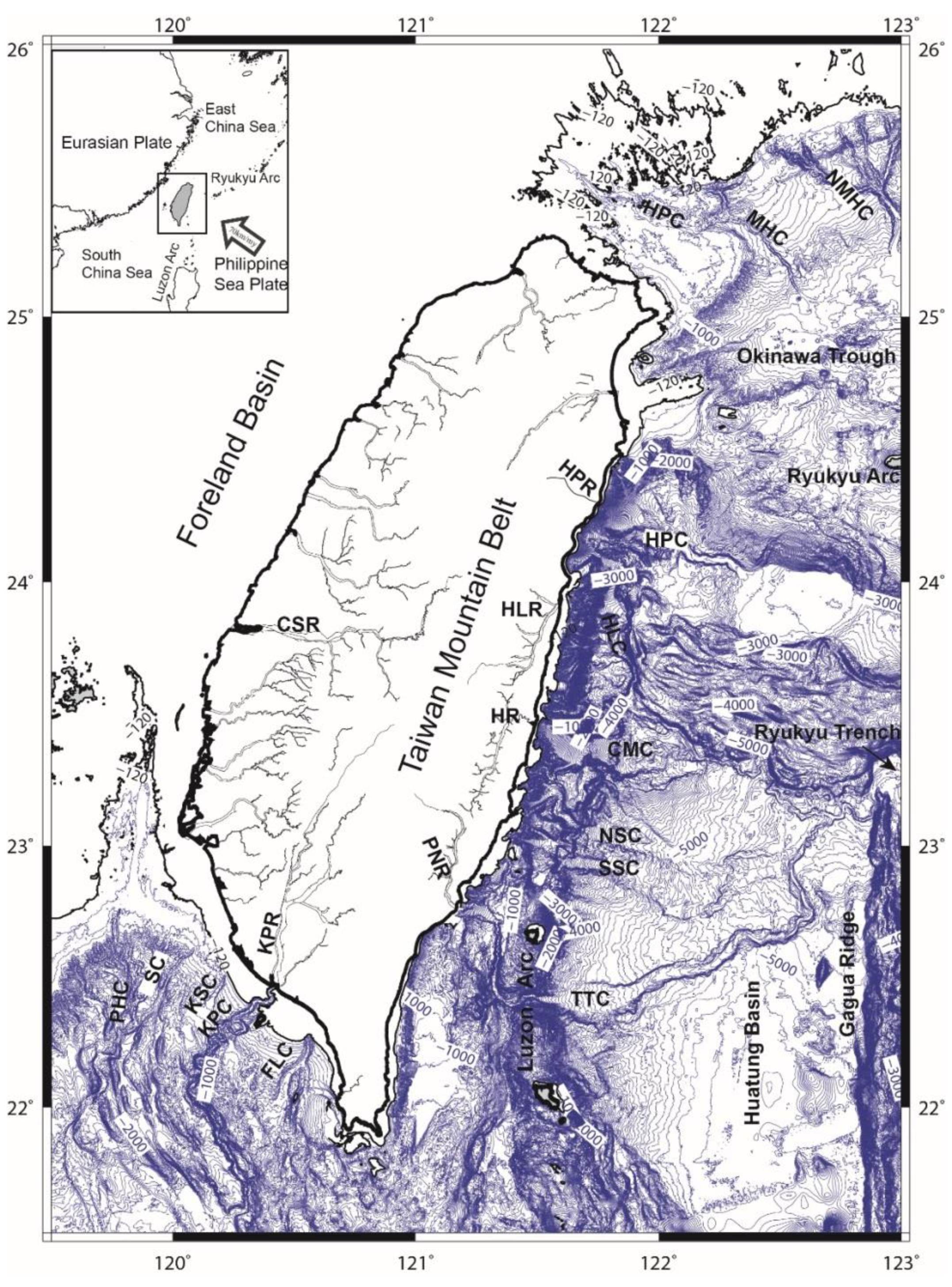
2. Geological Setting

The island of Taiwan lies along the Philippine Sea Plate’s western boundary, where the Ryukyu and Luzon arcs meet (Figure 1). Ongoing mountain building has resulted in steep mountain ranges on Taiwan island. The Taiwan orogen links two subduction zones, which dip in opposite directions. The Manila subduction zone is the eastward dipping Eurasian lithosphere and the Ryukyu subduction zone is the northward dipping Philippine Sea lithosphere [23]. South of Taiwan, the foreland region along the Chinese margin is flexed downward. This is due to the topographic loading of the Taiwan orogen. In turn, an east-dipping, wedge-shaped foreland basin is created, which flanks the Taiwan orogen [24,25,26]. To the northeast, the Philippine Sea Plate slab is accompanied by the southward retreat of the Ryukyu trench, with the Okinawa back-arc domain opening and extending into the northern Taiwan mountain belt.
The submarine canyons around Taiwan are ideal for studying the associations of hyperpycnal flows and canyon formation due to favorable geological and climatic settings (Figure 1 and Table 1). Due to its subtropical climate, it has a mean annual precipitation of 2.5 m/year, with an average of four typhoons annually. Frequent earthquakes result in landsliding processes and the production of sediment (384 Mt/yr), representing 30% of Taiwan’s total sediment discharge to the ocean [27]. The resulting high sediment flux from onshore catchments is a key factor for shelf incision by canyons [22]. In addition, small mountain rivers in tectonically active Taiwan are moderately turbid. High suspension loads can generate hyperpycnal flows at the mouth at a rate of approximately one per 100 years [28,29]. Such rivers can potentially deliver much sediment to the canyon heads, where gravity flows can erode the canyon head and floor and keep the canyon active.

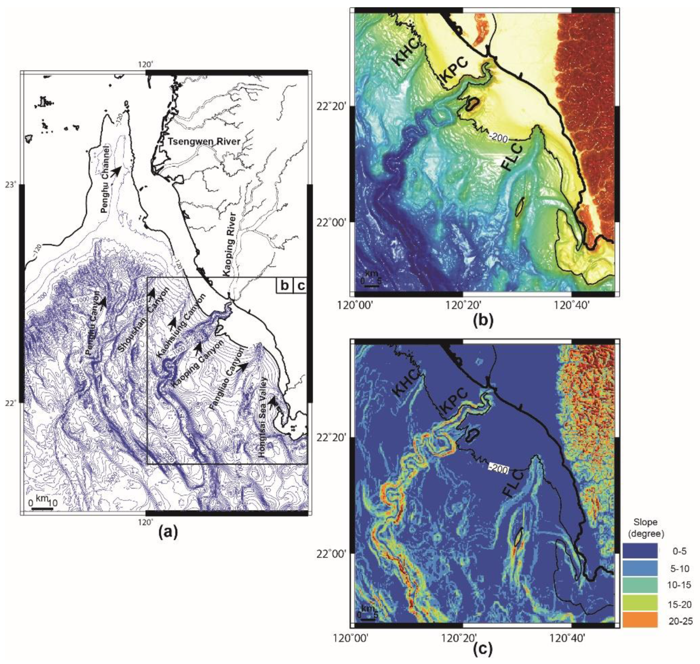
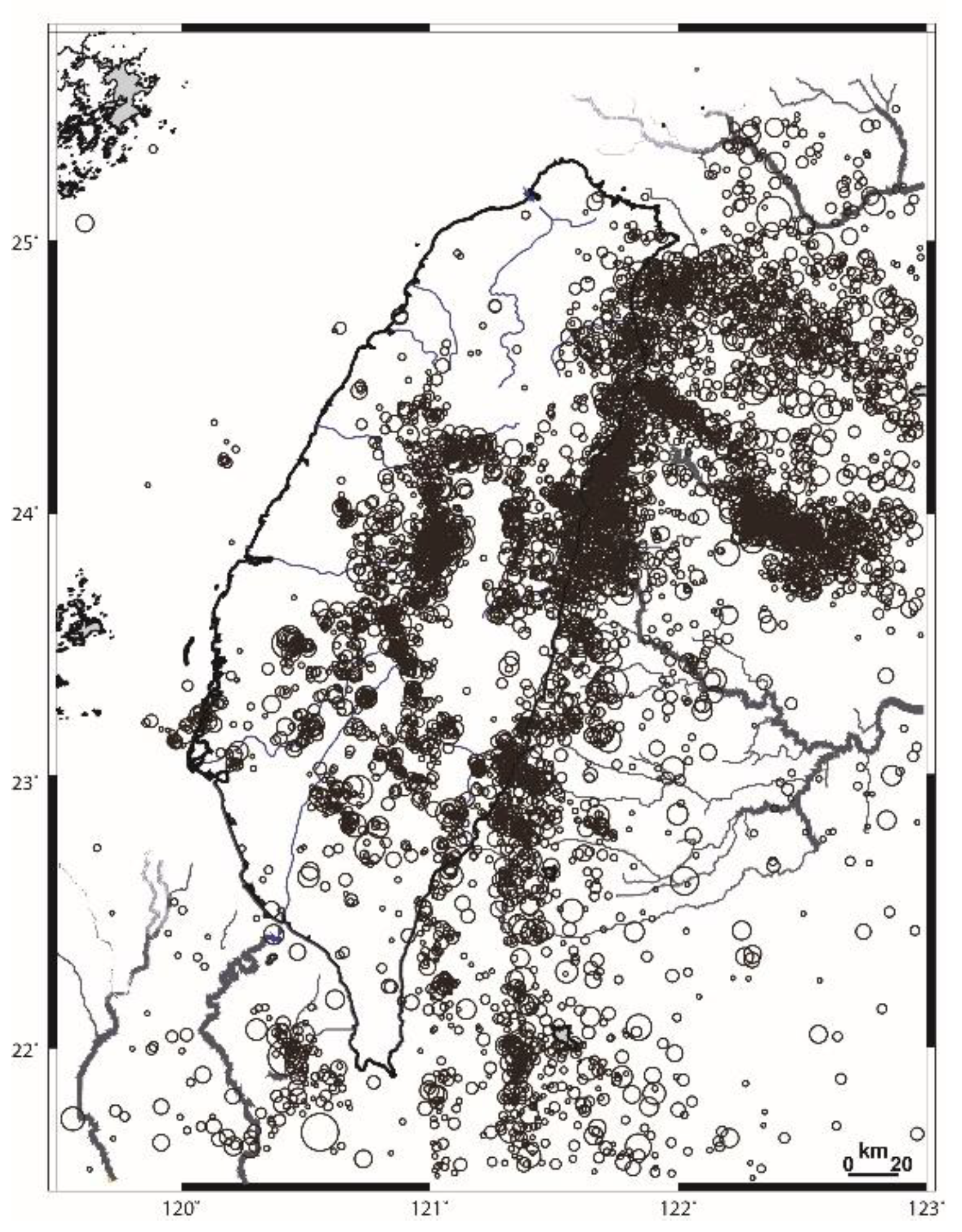
2.1. SW Taiwan Margin

On the SW Taiwan margin, the shelf–slope region is structurally dominated by folds, faults, and mud diapirs formed by younger compression adjacent to the Taiwan Mountain Belt. Diapiric intrusions and thrust faults affect the course direction, intensity of incision, and morphology of canyons off the shore of SW Taiwan [15,30,31,32]. Morphologically, the relatively narrow Kaoping Shelf (<20 km) and the broad Kaoping Slope dominate the continental margin off the shore of SW Taiwan.
Submarine canyons and sea valleys are distributed along the shelf and slope off SW Taiwan. There are five named submarine canyons on the Kaoping shelf–slope region (Figure 1). Among these canyons, only the Kaoping Canyon extends seaward from the mouth of the Kaoping River and crosses the upper Kaoping Slope to merge into the Penghu Canyon (Figure 1). The Kaoping Canyon is characterized as a river-connecting canyon on the continental margin off the shore of SW Taiwan [15].

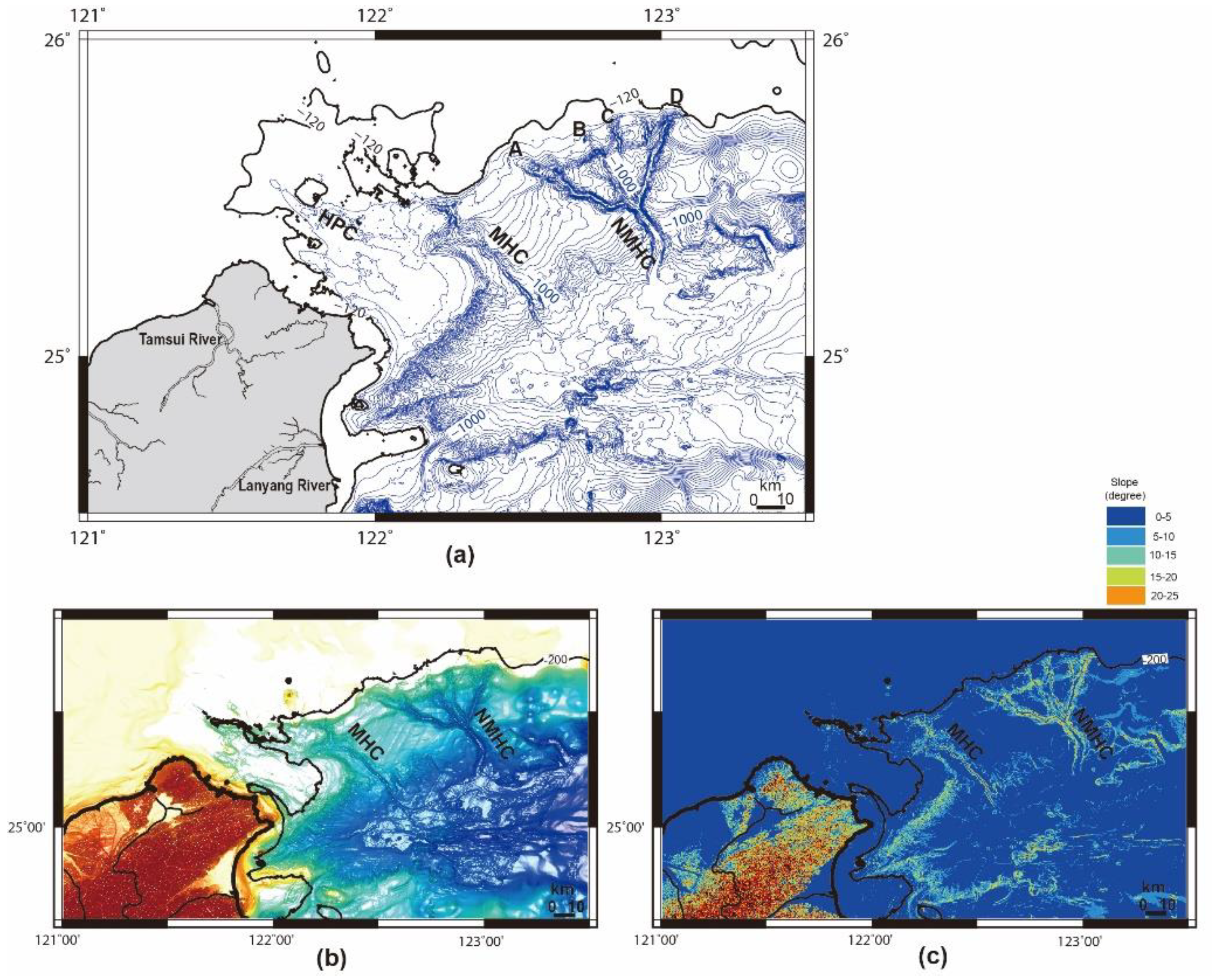
2.2. NE Taiwan Margin

The continental margin off NE Taiwan consists mainly of the broad ECS shelf, the narrow ECS slope, and the deep SOT (Figure 1). The ECS shelf that extends from the Mainland China coast seawards is relatively flat and wide, measuring about 400 km in width, with its edge being shallower than 140 m [33]. The ECS slope near Taiwan is characterized by irregular sea floor features, with an average slope angle of about 1.5 degrees [34,35].
Linear depressions, such as sea valleys, canyons, channels, and gullies, are prominent morphological features of the shelf–slope region off NE Taiwan. The Chilung Sea Valley occurs along the northern coast of Taiwan and is characterized by a relatively small and short linear trough, with low reliefs of about 20 m along its valley axis. East of the Chilung Sea Valley, two canyons, named Mienhua and North Mienhua, indent the ECS shelf [20].

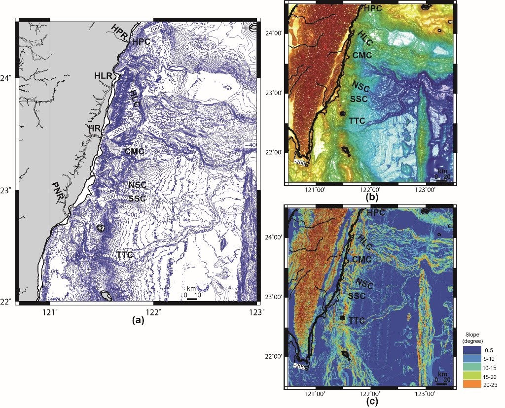
2.3. East Taiwan Margin

The East Taiwan margin is located in the westernmost part of the Huatung Basin (Figure 1). The inland area of the margin progressively shortens northwards to become the coastal range thrust belt. This has been significantly deformed due to rapid surface uplift (5–10 mm/yr) [36]. Most of the deformation is consumed in Eastern Taiwan (about two-thirds or 6 cm/yr of the total 9 cm/yr plate convergence), including the Luzon Arc, Luzon forearc basin, and adjacent Huatung Basin. This has led to the formation of the East Taiwan thrust belt, composed of the coastal range and the offshore shelf–slope region [36]. The offshore region of eastern Taiwan includes a narrow steep shelf (<10 km), a steep slope (15–20°), the deep oceanic Huatung basin, and the N–S-trending Gagua Ridge [37,38] (Figure 1).
Submarine canyons and channels have developed along the East Taiwan margin, extending from the narrow shelf and crossing rugged slope to the deep-sea basin. Six major submarine canyons, i.e., Hoping, Hualien, Chimei, North Sanxian, South Sanxian, and Taitung, stretch from north to south for a distance of 220 km along the east coast (Figure 1). These canyons are the main sediment conduits for transporting terrigenous sediment discharged from eastern Taiwan to the Huatung Basin [36,37,38,39].

3. Data and Methods

Recent studies on the maintenance of active submarine canyons during the present-day sea-level highstand have emphasized the efficiency of terrestrial sediment input to canyon heads [3,17,21]. In this study, we followed the approach of Bernhardt and Schwanghart (2021, p. 2) [21] to determine the distance from each canyon head to the present-day shoreline and to the 120 m depth contour (LGM shoreline). Canyon heads located <6 km from either shoreline are classified as shore-connected canyons [21]. Shore-connected canyons are assumed to receive terrestrial sediment directly from the shore by river input or longshore sediment transport. Accordingly, submarine canyons off the shore of the Taiwan margin were classified into three types, i.e., shore-connected, 120 m depth contour, and slope-confined canyons.
Bathymetric data were collectively acquired by R/V Researcher I and R/V Researcher II, operated by National Taiwan University and National Taiwan Ocean University, respectively, and inputted into bathymetric data. These data, operated by the National Center for Ocean Research at National Taiwan University, were used to produce the bathymetric charts and profiles for this study. The processing of bathymetric data included navigation data editing, offset adjustment, gridding, and the filtering and smoothing of gridded data. The newly compiled digital bathymetric model was generated with 200 m grid spacing. All data were post-processed and displayed using MapInfo and GMT software, respectively.

4. Results

4.1. SW Taiwan Margin

Penghu Canyon is characterized as a N–S-trending canyon eroding up-slope towards the Taiwan Strait Shelf and reaching the 200 m depth contour on the upper slope. The N–S-trending axis of Penghu Canyon is aligned with the course of Penghu Channel to the north, with its canyon head at a distance of 28 km from the shoreline. The head of Shoushan Canyon is at a depth of about 270 m and a distance of 25 km from the shoreline and confined to the upper slope (Figure 2 and Table 2).
The head of Kaohsiung Canyon is at a distance of 10 km from the shoreline (Figure 2). The head of Kaohsiung Canyon extends landward nearly to the 120 m depth contour. Kaoping Canyon is connected to a drainage system on land at present, with a deep incision into Kaoping Shelf. Its head is near the mouth of Kaoping River (Figure 2). The head of Fangliao Canyon is at a distance of 7 km and its head incises into the shelf landward, with its head reaching the 120 m depth contour (Table 2).

4.2. NE Taiwan Margin

The Mienhua Canyon head extends landward nearly to the 120 m depth contour. North Mienhua Canyon is situated 30 km NE of Mienhua Canyon with four distinct heads (Figure 1 and Figure 3), three (A, C, D) of which extend up-slope nearly to the 120 m depth contour (Table 3). The head of Mienhua Canyon with two small branches is located immediately below the 120 m depth (Table 3). The shapes of the head areas of these two submarine canyons have evolved in response to slope failures and mass wasting along the shelf edges of the NE Taiwan margin [20,40]. The heads of these two submarine canyons are located at a distance greater than 250 km from the present shoreline along eastern mainland China, separated by the very wide East China Sea Shelf.

4.3. East Taiwan Margin

The Hoping, Hualien, Chimei, and Taitung canyons are deeply incised into the continental shelf/slope region, with their heads near the mouth of present-day rivers, representing typical shore-connected canyons (Figure 4). The heads of the North Sanxian Canyon and South Sanxian Canyon are located close to the present-day shoreline, within 6 km. Therefore, they are also considered shore-connected canyons, although they are not located in front of present-day river mouths and have no direct terrestrial sediment input (Table 4).

5. Discussion

5.1. Types and Occurrences of Submarine Canyons off the Shore of Taiwan

The submarine canyons off the shore of Taiwan can be divided into three distinct categories: (1) shore-connected, (2) 120 m contour, and (3) slope-confined. The head of Kaoping Canyon continues to receive terrestrial input from Kaoping River, allowing it to remain active with the eroding of the canyon floor and transporting of sediment loads down-canyon to the deep sea (i.e., South China Sea). Adjacent to Kaoping Canyon are two 120 m depth contour canyons: the Kaohsiung and Fangliao Canyons (Figure 2). The heads of these two canyons are not associated with present-day rivers inland. Chiang et al. (2020) [15] reported that these two canyon heads are unable to capture longshore transported sediments from the shelf. As such, they remain relatively inactive, with the eroding of the canyon floor landward. It is noted that both canyons extend down-slope and terminate in the upper slope, with their mouths shallower than the 900 m depth contour (Figure 2). The Penghu and Shoushan Canyons are confined to the upper slope without terrestrial sediment input and restricted longshore transported sediment supply. As their heads have been unable to actively erode headward, they became far away from the shelf edge during the Holocene sea-level rise.
Off the shore of NE Taiwan, the Mienhua and North Mienhua Canyons (Figure 3) are inactive, as they have been unable to effectively erode headward to reach the present-day shoreline [21]. The heads of the Mienhua and North Mienhua Canyons are restricted to the 120 m depth contour due to the cut-off of terrestrial sediment input during the Holocene sea-level rise. It is worth mentioning that these two canyons are still actively transporting sediment down-canyon to the SOT [20]. Even though they are able to transport sediment down-canyon to the deep ocean basin, the Mienhua and North Mienhua canyons are inactive in terms of landward and headward erosion. However, they are active with regard to sediment transport along the canyon course by local currents or turbidity currents [20].
In contrast, there are six major shore-connected canyons off the East Taiwan margin. Figure 4 shows that they begin at the mouths of rivers or the shoreline and cross the narrow shelf (<10 km width), with their full courses entirely in the steep and rugged slope region. The heads of these six canyons receive adequate terrestrial sediment input and erode headward at a pace consistent with the millennial-scale sea-level rise during the Holocene.
The results of the present study indicated that the Taiwan margin is dominated by a combination of shore-connected canyons (n = 7, 54%) and 120 m contour canyons (n = 4, 31%), followed by slope-confined canyons (15%). Although we present a canyon system with a spatially limited distribution, there is a high density of shore-connected and 120 m contour canyons when compared with other regions of the world. This is in contrast to the low percentage of shore-connected canyons in the other regions of the world (4%). The high percentage of shore-connected canyons in Taiwan is comparable to that of the Mediterranean Sea region. The eastern Taiwan, Palomores, and SE Tyrrhenian margins are tectonically active regions. The regional uplift rates for eastern Taiwan range from 4.7 to 6.4 mm/yr [41]. The Palomores and SE Tyrrhenian margins have uplift rates of 0.023 to 0.046 mm/yr and less than 0.1 mm/yr, respectively [42]. The uplifted coastal ranges of these three margins are characterized by short and steep rivers that transport much sediment to the river mouths and narrow shelves. The riverine sediments are easily captured by canyons on the narrow shelves of these three margins, as mentioned in the introduction. Riverine sediments accumulated at the heads of these canyons are triggered to generate sediment gravity flows periodically, which keep these canyons active and maintain their heads close to the shorelines during sea-level rise.
Bernhardt and Schwanghart (2021) [21] indicated greater numbers of shore-connected canyons along active margins characterized by narrow and steep shelves and onshore catchments exposing resistant bedrock to the continental margin. Due to Taiwan’s geological setting, large amounts of terrestrial sediment are transported to the surrounding seas [29]. For example, much sediment has been directly delivered to the East Taiwan margin to feed canyons on the narrowest shelf (shelf width <10 km). Not surprisingly, six shore-connected canyons occur on the East Taiwan margin, as such canyons are associated with shelf gradients exceeding 5° (Figure 4c) and the minimal difference in width (<27 km) between the present-day and LGM shelf widths. This can be observed along the active Mediterranean margin and the Pacific coast in central South America and Central America [21]. Similar to the shore-connected canyons on the eastern Taiwan margin, the shore-connected Kaoping Canyon is situated on a narrow shelf with a direct and large fluvial sediment input. There are fewer shore-connected canyons along the SW Taiwan margin than on the East Taiwan margin, probably due to the wider shelf and lack of other major rivers delivering sediment to Kaoping Shelf.

5.2. Controls of Submarine Canyons Connected to the Shore

Sediment supply and shelf width are considered to be the major controls of submarine canyons around Taiwan connected to the shore during the present highstand. Seismic activity and typhoon-induced flooding are also significant influences. Here, we focus on the relationships among these factors and the maintenance of shore-connected canyons along Taiwan’s margins.
There is only one shore-connected canyon (i.e., Kaoping Canyon) on the SW Taiwan margin. The remaining canyons are 120 m contour and slope-confined canyons (Figure 2). Table 1 shows that Kaoping River has a relatively high suspended sediment discharge (49 MT/yr), resulting in the delivery of large amounts of sediment to the head of Kaoping Canyon. The 2006 Pingtung Earthquake and 2009 Typhoon Morakot, which resulted in flooding along the offshore SW Taiwan margin, led to the generation of turbidity currents in Kaoping Canyon. The result was not only the erosion of the canyon floor with the transport of sediments down-canyon, but also damage to communication cables [43]. Gavey et al. (2017) [44] pointed out that, on the SW Taiwan margin, Kaoping River’s extremely high discharge is associated with narrow shelf incision by Kaoping Canyon proximal to direct river input, which favors the occurrence of sediment density flows triggered by earthquakes and typhoon-induced flooding. Earthquakes of magnitude Mw 3.0 to 7.1 can trigger turbidity currents in Kaoping Canyon. Ikehara et al. (2020) [45] also consider earthquakes as significant triggers of turbidity currents on the SW Taiwan margin. For submarine canyons on the offshore Taiwan margin, Chiang et al. (2020) pointed out that this large fluvial sediment input is triggered by frequent earthquake and typhoon events which generate episodic gravity-driven sediment flows, allowing the continuous erosion of the canyon floor and transportation of sediment down-canyon [15]. As a result, Kaoping Canyon remains connected to the mouth of Kaoping River. Why have the adjacent Kaohsiung and Fangliao canyons not eroded landward to cross the short shelf (<20 km) and reach the shoreline? Firstly, the SW coastal plain of Taiwan is mostly occupied by Kaoping River drainage. No other major rivers have developed here (Figure 2). As a result, the heads of Kaohsiung and Fangliao canyons are not aligned to rivers inland at present. Consequently, these two canyons do not have direct access to terrestrial sediment input and their heads do not erode to cross the relatively short shelf. Secondly, more than 80% of the sediment load of Kaoping River is delivered to Kaoping Canyon, and less than 20% is distributed to the Kaoping shelf–slope region, resulting in limited sediment supply to the shelf [46]. Not surprisingly, the heads of the Kaohsiung and Fangliao Canyons are unable to capture longshore-transported sediments from the shelf [15]. The lack of terrestrial sediment input combined with restricted longshore transported sediment supply has meant that the headward erosion and retrogressive instability of the Kaohsiung and Fangliao Canyons was not fast enough to enable them to reach the shore during the Holocene sea-level rise. Therefore, it is suggested that direct terrestrial sediment input and narrow shelf possible are the two main controls of the canyons connected to the shore along the SW Taiwan margin.
The Mienhua and North Mienhua Canyons are associated with the very wide ECS Shelf (Table 3) in contrast to the canyons of the SW and eastern Taiwan margins which are associated with narrow shelves (<20 km). Wide shelf canyons commonly lack terrestrial sediment input to their heads and are considered inactive canyons with regard to headward and landward canyon incisions [47,48]. During the LGM sea-level lowstand, the heads of the Mienhua and North Mienhua Canyons were close to the paleo-shoreline of Mainland China, where they received terrestrial sediment supply to maintain headward erosion. With the sea-level rise during the Holocene highstand, the relatively wide ECS Shelf was immersed and the paleo-shoreline migrated landward, resulting in the canyon heads being separated from the shore by relatively long distances. It is suggested that the main control of the Mienhua and North Mienhua Canyons is inhibited access to fluvial sediment supply due to the wide continental shelf. The intensity of canyon erosion with sediment flows generated by fluvial input decreased and headward incision could not keep pace with the sea-level rise. Therefore, the heads remained at the 120 m contour and these two canyons were inactive.
Although episodic earthquake events and flooding can enhance the intensity or magnitude of erosion of the canyon floor, as well as the transport of sediment flows, in Mienhua Canyon [49], the influences of typhoons and earthquakes on headward erosion are insignificant compared to those of sediment input and narrow shelf. Sediment input is a necessity for the generation of erosive sediment flows in its canyon head segment. Furthermore, the shapes of the heads of these two canyons indicated that slope failures and mass wasting have taken place along the shelf edge and upslope of the NE Taiwan margin. The resulting slope gullies in the shelf–slope region have evolved into branched and multi-head canyons, respectively [20,40]. Apparently, the down-slope erosion is more intense than the up-slope erosion (headward erosion) of these two canyons because of the steepness of upslope areas and lack of terrestrial sediment input. Therefore, the wide shelf and lack of direct terrestrial sediment input were the two major factors that kept the heads of Mienhua and North Mienhua canyons at the 120 m water depth during the Holocene sea-level rise.
The eastern margin of Taiwan is characterized by shore-connected canyons (Figure 4) and a shelf that is narrow (<10 km) and steep (>5°). Beyond this shelf, the upper slope displays steep gradients (15 to 20°) and is deeply incised by the dendritic pattern of the canyons (Figure 4C). Frequent earthquakes in the shelf-slope region east of Taiwan are caused by an oblique collision between the Eurasian Margin and Luzon Arc ([36]; Figure 5). In addition, the eastern Taiwan margin experiences an average of four typhoons every year [37], with typhoon-triggered flooding of major rivers and high sediment transport to the shore and adjacent submarine canyons [38]. Figure 4 shows that the heads of the major canyons are connected to river mouths, except for those of the North Sanxian and South Sanxian Canyons. For example, Taitung Canyon is connected to Peinan River, which has very high suspended sediment discharge (88 Mt/yr; [29]). Earthquake-triggered canyon flushing, as a primary driver of canyon incision and sediment transport, has been observed in Kaikōura Canyon, Central New Zealand [50]. Flooding-induced hyperpycnal flows have been reported in the head of Kaoping Canyon [15,51]. Taitung Canyon remains active as a conduit for terrestrial sediment from eastern Taiwan to the deep Ryukyu Trench to the north [39].
As shown in Figure 5, the eastern Taiwan margin is characterized by extreme seismicity with frequent earthquakes of magnitude Mw 7.7 [37]. This is important for the development of shore-connected canyons along the eastern Taiwan margin. In general, there are two ways for earthquakes to trigger the generation of gravity-driven sediment flows in submarine canyons: earthquakes cause the failures of canyon walls, with slumping or sliding that evolve into turbidity currents in the canyon, and accumulated river-fed sediments generate hyperpycnal flows or turbidity currents in the canyon head segment. Earthquakes are considered the main mechanism for the generation of small-scale failures (i.e., gullies and small channels) in the shelf edge–upslope region on the eastern Taiwan margin [37]. Therefore, in submarine canyons on the eastern margin, river-fed sediments, together with sediments from collapsed canyon walls in the canyon heads, are triggered by frequent earthquakes to generate erosive sediment flows which, in shore-connected canyons, keep the canyon head actively eroding the canyon floor and connected to the river mouth.
In summary, the shore-connected submarine canyons on the eastern Taiwan margin represent a regional example of important controls of high sediment yields enhanced by typhoon-related flooding and a very narrow shelf, allowing much terrestrial sediment to be delivered to the canyon heads. This is coupled with frequent earthquakes that trigger erosive sediment flows in the canyons.
Therefore, the sea-level changes from the LGM to the present, sediment input to the canyon heads, and shelf width are the major factors in controlling submarine canyons on the Taiwan margins that are connected to the shore in the present day. Tectonics and climate are also critical factors. The former controls the frequent earthquakes and rapid uplift rate, which trigger sediment failure and the generation of gravity sediment flows. The latter contributes to the terrestrial sediment feeding of canyon heads to generate hyperpycnal flows during flooding events.

5.3. Development of Submarine Canyons off Taiwan Margin since the LGM

During the LGM, there was a lowering of the sea level by 120 m, with most of the Taiwan Strait shelf subaerially exposed. A series of submarine channels and canyons developed on the NE, East, and SW Taiwan margins (Figure 6a). There were eleven noticeable submarine canyons with their heads located close to the paleo-shoreline, which coincides with the present-day 120 m depth contour (Figure 6a). The last glaciation took place about 20,000 years ago. Since then, the sea level has risen 120 m [21], with subsequent transgression some 5 to 7 ka BP, when the sea level rose to close to the present position of the paleo-shoreline around Taiwan [20]. As a result, most of the subaerially exposed Taiwan Strait was submerged and the distance between the canyon heads and river mouths increased. The Mienhua and North Mienhua canyons off the shore of NE Taiwan have evolved into 120 m contour canyons, because their headward erosion did not keep up with the magnitude of the sea-level rise. During the LGM, canyon heads close to the paleo-shoreline possessed the capacity to receive nearby fluvial and shelf sediments.
Figure 6a also shows that, about 20,000 years ago, three paleo-canyons along the SW Taiwan margin were associated with a narrow shelf (<20 km) and a short distance between canyon heads and shoreline. Since the LGM, the sea level has risen by about 120 m and the shoreline has migrated landward with the inundation of shelf areas. As a result, seven paleo-canyons have maintained their connection to the present shoreline. Among the remaining paleo-canyons, their heads are located at the 120 m depth contour (Figure 6b). The decreasing number of shore-connected canyons in the Taiwan region, associated with sea-level rise in the Holocene, has mainly been influenced by sediment input and shelf width. These results agree with the observations of Bernhardt and Schwanghart (2021) [21].

6. Conclusions

The Taiwan margin is dominated by the combination of shore-connected canyons (n = 7, 54%) and 120 m contour canyons (n = 4, 31%). There are also two slope-confined canyons (15%). Shore-connected canyons preferentially occur along the active margin of East Taiwan, with narrow and steep shelves and heads aligned with and connected to river mouths that have large sediment discharge. Therefore, the sea level changes from the LGM to the present, sediment input to the canyon heads, and shelf width are the major factors for controlling connections of submarine canyons with the shore along the Taiwan margin in the present highstand. These two controls are in addition to tectonics and earthquake influences. In particular, frequent earthquake events are considered a significant factor in the development of shore-connected canyons in eastern Taiwan.

Author Contributions

Conceptualization, C.-S.C.; original draft preparation, C.-S.C.; interpretation, C.-S.C.; review and editing, H.-S.Y.; funding acquisition, C.-S.C. All authors have read and agreed to the published version of the manuscript.

Funding

This study was financially supported in part by the Ministry of Science and Technology (MOST 109-2116-M-178-003), Taiwan.

Institutional Review Board Statement

Not applicable.

Informed Consent Statement

Not applicable.

Data Availability Statement

Not applicable.

Acknowledgments

We would like to thank the captain and crew of R/V Ocean Research I, II, and V who helped to collect the multibeam bathymetric data for this study. We greatly appreciate being granted access to bathymetric data from the Ocean Data Bank of the National Center for Ocean Research, Taiwan. The authors are also grateful to the two anonymous reviewers, whose suggestions greatly improved the manuscript.

Conflicts of Interest

The authors declare no conflict of interest.

References

  1. Walsh, J.P.; Alexander, C.R.; Gerber, T.; Orpin, A.R.; Sumners, B.W. Demise of a submarine canyon? Evidence for highstand infilling on the Waipaoa River continental margin, New Zealand. Geophys. Res. Lett. 2007, 34, L20606. [Google Scholar] [CrossRef]
  2. Posamentier, H.; Erskine, R.; Mitchum, R., Jr. Models for Submarine-fan deposition within a sequence stratigraphic framework. In Seismic Facies and Sedimentary Process of Submarine Fans and Turbidite Systems; Springer: New York, NY, USA, 1991. [Google Scholar]
  3. Covault, J.A.; Graham, S.A. Submarine fans at all sea-level stands: Tectono-morphologic and climatic controls on terrigenous sediment delivery to the deep sea. Geology 2010, 38, 939–942. [Google Scholar] [CrossRef]
  4. Bernhardt, A.; Melnick, D.; Jara-Muñoz, J.; Argandoña, B.; González, J.; Strecker, M.R. Controls on submarine canyon activity during sea-level highstands: The Biobío canyon system offshore Chile. Geosphere 2015, 11, 1226–1255. [Google Scholar] [CrossRef] [Green Version]
  5. Chiocci, F.L.; Casalbore, D. Unexpected fast rate of morphological evolution of geologically-active continental margins during Quaternary: Examples from selected areas in the Italian seas. Mar. Pet. Geol. 2017, 82, 154–162. [Google Scholar] [CrossRef]
  6. Pierdomenico, M.; Casalbore, D.; Chiocci, F.L. The key role of canyons in funnelling litter to the deep sea: A study of the Gioia Canyon (Southern TyrrhenianSea). Anthropocene 2020, 30, 100237. [Google Scholar] [CrossRef]
  7. Casalbore, D.; Biancone, M.; Casas, D.; Mata, P.; Alonso, B.; Ercilla, G.; Chiocci, F.L.; Bárcenas, P.; López-González, N. Holocene morpho-stratigraphic evolution of a compound submarine deltaic system in front of the shelf-incising Almanzora and Garrucha Canyons (Palomares margin, southeastern Iberia). Mar. Geol. 2022, 444, 106708. [Google Scholar] [CrossRef]
  8. Babonneau, N.; Savoye, B.; Cremer, M.; Klein, B. Morphology and architecture of the present canyon and channel system of the Zaire deep-sea fan. Mar. Pet. Geol. 2002, 19, 445–467. [Google Scholar] [CrossRef]
  9. Khripounoff, A.; Vangriesheim, A.; Babonneau, N.; Crassous, P.; Dennielou, B.; Savoye, B. Direct observation of intense turbidity current activity in the Zaire submarine valley at 4000 m water depth. Mar. Geol. 2003, 194, 151–158. [Google Scholar] [CrossRef] [Green Version]
  10. Khripounoff, A.; Vangriesheim, A.; Crassous, P.; Etoubleau, J. High frequency of sediment gravity flow events in the Var submarine canyon (Mediterranean Sea). Mar. Geol. 2009, 263, 1–6. [Google Scholar] [CrossRef] [Green Version]
  11. Casalbore, D.; Chiocci, F.L.; Mugnozza, G.S.; Tommasi, P.; Sposato, A. Flash-food hyperpycnal flows generating shallow-water landslides at Fiumara mouths in Western Messina Strait (Italy). Mar. Geophys. Res. 2011, 32, 257–271. [Google Scholar] [CrossRef]
  12. Pierdomenico, M.; Casalbore, D.; Chiocci, F.L. Massive benthic litter funnelled to deep sea by flash-flood generated hyperpycnal flows. Sci. Rep. 2019, 9, 5330. [Google Scholar] [CrossRef] [PubMed] [Green Version]
  13. Liu, J.T.; Liu, K.J.; Huang, J.C. The effect of a submarine canyon on the river sediment dispersal and inner shelf sediment movements in southern Taiwan. Mar. Geol. 2002, 181, 357–386. [Google Scholar] [CrossRef]
  14. Yu, H.S.; Chiang, C.S.; Shen, S.M. Tectonically active sediment dispersal system in SW Taiwan margin with emphasis on the Gaoping (Kaoping) Submarine Canyon. J. Mar. Syst. 2009, 76, 369–382. [Google Scholar] [CrossRef]
  15. Chiang, C.S.; Hsiung, K.H.; Yu, Y.S.; Chen, S.C. Three types of modern submarine canyons on the tectonically active continental margin offshore southwestern Taiwan. Mar. Geophy. Res. 2020, 41, 4. [Google Scholar] [CrossRef]
  16. Chiang, C.S.; Yu, H.S. Morphological Significance and Relation of Ecosystems of Submarine Canyons off SW Taiwan. J. Mar. Sci. Eng. 2021, 9, 1296. [Google Scholar] [CrossRef]
  17. Covault, J.A.; Normark, W.R.; Romans, B.W.; Graham, S.A. Highstand fans in the California borderland: The overlooked deep-water depositional system. Geology 2007, 35, 783–786. [Google Scholar] [CrossRef] [Green Version]
  18. Hung, J.J.; Lin, C.S.; Chung, Y.C.; Hung, G.W.; Liu, W.S. Lateral fluxes of biogenic particles through the Mien-Hua canyon in the Southern East China Sea Slope. Cont. Shelf Res. 2003, 23, 935–955. [Google Scholar] [CrossRef]
  19. Hsu, S.C.; Lin, F.J.; Jeng, W.L.; Chung, Y.C.; Shaw, L.M.; Hung, K.W. Observed Sediment Fluxes in the Southwesternmost Okinawa Trough enhanced by episodic events: Flood runoff from Taiwan rivers and large earthquakes. Deep Sea Res. Oceanogr. Res. Pap. 2004, 51, 979–997. [Google Scholar] [CrossRef]
  20. Chiang, C.S.; Yu, H.S.; Noda, A.; TuZino, T. The Huapinghsu Channel/Mienhua Canyon System as a Sediment Conduit Transporting Sediments from Offshore North Taiwan to the Southern Okinawa Trough. Front. Earth Sci. 2022, 9, 792595. [Google Scholar] [CrossRef]
  21. Bernhardt, A.; Schwanghart, W. Where and why do submarine canyons remain connected to the shore during sea-level rise? Insights from global topographic analysis and Bayesian regression. Geophys. Res. Lett. 2021, 48, e2020GL092234. [Google Scholar] [CrossRef]
  22. Harris, P.T.; Whiteway, T. Global distribution of large submarine canyons: Geomorphic differences between active and passive continental margins. Mar. Geol. 2011, 285, 69–86. [Google Scholar] [CrossRef]
  23. Suppe, J. Kinematics of arc-continent collision, flipping of subduction, and back-arc spreading near Taiwan. Mem. Geol. Soc. China 1984, 6, 21–33. [Google Scholar]
  24. Covey, M. Lithofacies analysis and basin reconstruction, Plio-Pleistocene western Taiwan foredeep. Petrol. Geol. Taiwan 1984, 20, 53–83. [Google Scholar]
  25. Yu, H.S.; Chou, Y.W. Characteristics and development of the flexural forebulge and basal unconformity of Western Taiwan Foreland Basin. Tectonophysics 2001, 333, 277–291. [Google Scholar] [CrossRef]
  26. Chiang, C.S.; Yu, H.S.; Chou, Y.W. Characteristics of the wedge-top depozone of the southern Taiwan foreland basin system. Basin Res. 2004, 16, 65–78. [Google Scholar] [CrossRef]
  27. Dadson, S.J.; Hovious, N.; Chen, H.; Dade, W.B.; Hsieh, M.L.; Willett, S.D.; Hu, J.C.; Horng, M.J.; Chen, M.C.; Stark, C.P.; et al. Links between erosion, runoff variability and seismicity in the Taiwan orogen. Nature 2003, 426, 648–651. [Google Scholar] [CrossRef]
  28. Mulder, T.; Syvitski, J.P.M. Turbidity Currents Generated at River Mouths during Exceptional Discharges to the World Oceans. J. Geol. 1995, 103, 285–299. [Google Scholar] [CrossRef]
  29. Dadson, S.; Hovius, N.; Pegg, S.; Dade, W.B.; Horng, M.J.; Chen, H. Hyperpycnal river flows from an active mountain belt. J. Geophys. Res. 2005, 110, F04016. [Google Scholar] [CrossRef]
  30. Chiang, C.S.; Yu, H.S. Morphotectonics and incision of the Kaoping submarine canyon, SW Taiwan orogenic wedge. Geomorphology 2006, 80, 199–213. [Google Scholar] [CrossRef]
  31. Lin, A.T.; Yao, B.; Hsu, S.K.; Liu, C.S.; Huang, C.Y. Tectonic features of the incipient arc-continent collision zone of Taiwan: Implications for seismicity. Tectonophysics 2009, 479, 28–42. [Google Scholar] [CrossRef]
  32. Chen, S.C.; Hsu, S.K.; Wang, Y.S.; Chung, S.H.; Chen, P.C.; Tsai, C.H.; Liu, C.S.; Lin, H.S.; Lee, Y.W. Distribution and characters of the mud diapirs and mud volcanoes off southwest Taiwan. J. Asian Earth Sci. 2014, 92, 201–214. [Google Scholar] [CrossRef]
  33. Yu, H.S.; Hong, E. The Huapinghsu channel/canyon system off northeastern Taiwan: Morphology, sediment character and origin. Terr. Atmos. Ocean Sci. 1993, 4, 307–319. [Google Scholar] [CrossRef]
  34. Song, G.S.; Ma, C.P.; Yu, H.S. Fault genesis of the Chilung Sea Valley revealed by topographic lineaments. Mar. Geol. 2000, 169, 305–325. [Google Scholar] [CrossRef]
  35. Tsai, C.H.; Huang, C.L.; Hsu, S.K.; Doo, W.B.; Lin, S.S.; Wang, S.Y.; Lin, J.Y.; Liang, C.W. Active normal faults and submarine landslides in the Keelung Shelf off NE Taiwan. Terr. Atmos. Ocean Sci. 2018, 29, 31–38. [Google Scholar] [CrossRef] [Green Version]
  36. Hsieh, Y.H.; Liu, C.S.; Suppe, J.; Byrne, T.B.; Lallemand, S. The Chimei submarine canyon and fan: A record of Taiwan arc-continent collision on the rapidly deforming over-riding plate. Tectonics 2020, 39, e2020TC006148. [Google Scholar] [CrossRef]
  37. Lehu, R.; Lallemand, S.; Hsu, S.K.; Babonneau, N.; Ratzov, G.; Lin, A.T.; Dezileau, L. Deep-sea sedimentation offshore eastern Taiwan: Facies and processes characterization. Mar. Geol. 2015, 369, 1–18. [Google Scholar] [CrossRef]
  38. Hsu, H.H.; Liu, C.S.; Chen, T.T.; Hung, H.T. Stratigraphic framework and sediment wave fields associated with canyon-levee systems in the Huatung Basin offshore Taiwan Orogen. Mar. Geol. 2021, 433, 106408. [Google Scholar] [CrossRef]
  39. Hsiung, K.H.; Kanamatsu, T.; Ikehara, K.; Shiraishi, K.; Horng, C.S.; Usami, K. Morpho-sedimentary features and sediment dispersal systems of the southwest end of Ryukyu Trench: A source-to-sink approach. Geo. Mar. Lett. 2017, 37, 561–577. [Google Scholar] [CrossRef]
  40. Yu, H.S.; Lee, M.L. Morphological and seismic characteristics of the North Mienhua submarine canyon off northeastern Taiwan. Terr. Atmos. Ocean Sci. 1998, 9, 263–278. [Google Scholar] [CrossRef]
  41. Chen, W.S.; Yang, C.Y.; Chen, S.T.; Huang, Y.C. New insights into Holocene marine terrace development caused by seismic and aseismic faulting in the Coastal Range, eastern Taiwan. Quat. Sci. Rev. 2020, 240, 106369. [Google Scholar] [CrossRef]
  42. Zazo, C.; Goy, J.L.; Dabrio, C.J.; Bardaji, T.; Hillaire-Marcel, C.; Ghaleb, B.; Soler, V. Pleistocene raised marine terraces of the Spanish Mediterranean and Atlantic coasts: Records of coastal uplift, sea-level highstands and climate changes. Mar. Geol. 2003, 194, 103–133. [Google Scholar] [CrossRef] [Green Version]
  43. Hsu, S.K.; Kuo, J.; Lo, C.L.; Tsai, C.H.; Doo, W.B.; Ku, C.Y.; Sibuet, J.C. Turbidity currents, submarine landslides and the 2006 Pingtung earthquake off SW Taiwan. Terr. Atmos. Ocean Sci. 2008, 19, 767–772. [Google Scholar] [CrossRef] [Green Version]
  44. Gavey, R.; Carter, L.; Liu, J.T.; Talling, P.J.; Hsu, R.; Pope, E.; Evans, G. Frequent sediment density flows during 2006 to 2015, triggered by competing seismic and weather events: Observations from subsea cable breaks off southern Taiwan. Mar. Geol. 2017, 384, 147–158. [Google Scholar] [CrossRef]
  45. Ikehara, K.; Usami, K.; Kanamatsu, T. Repeated occurrence of surface-sediment remobilization along the landward slope of the Japan Trench by great earthquakes. Earth Planets Space 2020, 72, 114. [Google Scholar] [CrossRef]
  46. Huh, C.A.; Lin, H.L.; Lin, S.; Huang, Y.W. Modern accumulation rates and a budget of sediment off the Gaoping (Kaoping) River, SW Taiwan: A tidal and flood dominated depositional environment around a submarine canyon. J. Mar. Syst. 2009, 76, 405–416. [Google Scholar] [CrossRef]
  47. Popescu, I.; Panin, N.; Jipa, D.; Lericolais, G.; Ion, G. Submarine canyons of the Black Sea basin with a focus on the Danube canyon. CIESM Monogr. 2015, 47, 103–121. [Google Scholar]
  48. Jipa, D.C.; Panin, N. Narrow shelf canyons vs. wide shelf canyons: Two distinct types of Black Sea submarine canyons. Quat. Int. 2018, 540, 120–136. [Google Scholar] [CrossRef]
  49. Huh, C.A.; Su, C.C.; Liang, W.T.; Ling, C.Y. Linkages between Turbidites in the Southern Okinawa Trough and Submarine Earthquakes. Geophys. Res. Lett. 2004, 31, L12304. [Google Scholar] [CrossRef]
  50. Mountjoy, J.J.; Howarth, J.D.; Orpin, A.R.; Barnes, P.M.; Bowden, D.A.; Rowden, A.A.; Schimel, A.C.; Holden, C.; Horgan, H.J.; Nodder, S.D. Earthquakes drive largescale submarine canyon development and sediment supply to deep-ocean basins. Sci. Adv. 2018, 4, eaar3748. [Google Scholar] [CrossRef] [Green Version]
  51. Chiang, C.S.; Yu, H.S. Evidence of hyperpycnal flows at the head of the meandering Kaoping Canyon off SW Taiwan. Geo-Mar. Lett. 2008, 28, 161–169. [Google Scholar] [CrossRef]
Figure 1. Map showing river drainage and the surrounding bathymetric contours of Taiwan Island. Note the outline of the 120 m depth contour off the shore of Taiwan. Noticeable submarine canyons have developed on the shelf–slope regions. The inset in the upper-left corner shows the tectonic setting of Taiwan. CSR: Choshui River; KPR: Kaoping River; HPR: Hoping River; HLR: Hualien River; HR: Hsiukuluan River; PNR: Peinan River; PHC: Penghu Canyon; SSC: Shoushan Canyon: KHC: Kaohsiung Canyon; KPC: Kaoping Canyon; FLC: Fangliao Canyon; HPC: Huapinghsu Channel; MC: Mienhua Canyon; NMC: North Mienhua Canyon; HPC: Hoping Canyon; HLC: Hualien Canyon; CMC: Chimei Canyon; NSC: North Sanxian Canyons; SSC: South Sanxian Canyons; TTC: Taitung Canyon.
Jmse 10 00494 g001
Figure 2. (a) River drainage and surrounding bathymetric contours of the SW Taiwan margin. Note the outline of the 120 m depth contour off the shore of SW Taiwan. (b) Shaded relief map of SW Taiwan. (c) Slope gradient map of SW Taiwan. Note that the shelves on the SW Taiwan margin are characterized by slope gradients of between 0 and 5 degrees. Five canyons occur in the shelf region off the shore of SW Taiwan: the Penghu, Shoushan, Kaohsiung, Kaoping, and Fangliao Canyons. Hongtsi Sea Valley is situated east of the Fangliao Canyon.
Jmse 10 00494 g002
Figure 3. (a) River drainage and surrounding bathymetric contours of the NE Taiwan margin. Note the outline of the 120 m depth contour off the shore of NE Taiwan. (b) Shaded relief map of NE Taiwan. (c) Slope gradient map of NE Taiwan. Note that the shelves on the NE Taiwan margin are characterized by slope gradients of between 0 and 5 degrees. Mienhua and North Mienhua canyons, named for nearby islets, are confined to the slope areas. Huapinghsu Channel is aligned to the western branch of Mienhua Canyon [20]. HPC: Huapinghsu Channel; MHC: Mienhua Canyon; NMHC: North Mienhua Canyon.
Jmse 10 00494 g003
Figure 4. (a) River drainage and surrounding bathymetric contours of the East Taiwan margin. Note the outline of the 120 m depth contour off the shore of East Taiwan. (b) Shaded relief map of East Taiwan. (c) Slope gradient map of East Taiwan. Note that the slope gradient of the shelf along the East Taiwan margin is greater than 5 degrees. There are six major submarine canyons that stretch from north to south for a distance of 220 km along the narrow shelf off the eastern Taiwan coast. HPC: Hoping Canyon; HLC: Hualien Canyon; CC: Chimei Canyon; NSC: North Sanxian Canyon; SSC: South Sanxian Canyon; TC: Taitung Canyon; HPR: Hoping River; HLR: Hualien River; HR: Hsiukuluan River; PNR: Peinan River.
Jmse 10 00494 g004
Figure 5. Distribution of earthquakes in the Taiwan area (Data from Central Weather Bureau, Taiwan, 2012). Note that the eastern Taiwan margin is characterized by frequent earthquake events.
Jmse 10 00494 g005
Figure 6. The hypothesized distributions of paleo-rivers and canyons in the Taiwan area since the LGM. (a) There were relatively large numbers (n = 11) of shore-connected canyons in the Taiwan area during the LGM. (b) Seven canyons remain connected to the shore during the present sea-level highstand. Six shore-connected canyons occur on the eastern Taiwan margin and one on the SW margin.
Jmse 10 00494 g006
Table 1. Hyperpycnal discharges observed and predicted in Taiwan’s major coastal rivers. (Data from [27,28,29]).
WatershedDrainage Area
(km2)
Length (km)Suspended Sediment Discharge (Mt/yr)
Fengshan2082501
Taan63395.87
Tachia417124.21
Choshui298918654
Pachang44180.96
Tsengwen1157138.525
Erhjen17563.247
Kaoping325717149
Peinan158484.488
Hsiukuluan153981.222
Hualien150657.331
Hoping55350.715
Table 2. Comparisons of submarine canyons along the SW Taiwan margin.
CriterionPenghu CanyonShoushan CanyonKaohsiung CanyonKaoping CanyonFangliao Canyon
Canyon typeSlope-confined canyonSlope-confined canyon120 m depth contour canyon120 m depth contour canyonShore-connected canyon
Depth of the canyon head300 m560 m350 m50 m60 m
Morphology of canyon headBranched head segmentStraight head segmentStraight head segmentSinuous head segementStraight head segment
Canyon head to shoreline28 km25 km10 km1 km7 km
Depth of the canyon head300 m560 m350 m50 m60 m
Table 3. Comparisons of submarine canyons along the NE Taiwan margin.
CriterionMienhua CanyonNorth Mienhua Canyon
Canyon type120 m depth contour canyon120 m depth contour canyon
Morphology of canyon headBranched headMulti-heads
Canyon head to shoreline250 km280 km
Depth of the canyon head400 m350 m
Table 4. Comparisons of submarine canyons along the East Taiwan margin.
CriterionHoping CanyonHualien CanyonChimei CanyonNorth Sanxian CanyonSouth Sanxian CanyonTaitung Canyon
Canyon typeShore-connected canyonShore-connected canyonShore-connected canyonShore-connected canyonShore-connected canyonShore-connected canyon
Morphology of canyon head Straight head segmentStraight head segmentStraight head segmentStraight head segment Straight head segmentStraight head segment
Canyon head to shoreline0 km0 km0 km4.5 km4 km0 km
Depth of the canyon head450 m280 m350 m160 m220 m150 m
Publisher’s Note: MDPI stays neutral with regard to jurisdictional claims in published maps and institutional affiliations.

