Article

Ship Global Traveling Path Optimization via a Novel Non-Dominated Sorting Genetic Algorithm

School of Electrical Engineering and Automation, Jiangxi University of Science and Technology, Ganzhou 341000, China
*
Author to whom correspondence should be addressed.
J. Mar. Sci. Eng. 2024, 12(3), 485; https://doi.org/10.3390/jmse12030485
Submission received: 17 February 2024 / Revised: 10 March 2024 / Accepted: 11 March 2024 / Published: 14 March 2024

Abstract

:
Due to the intensification of economic globalization and the impact of global warming, the development of methods to reduce shipping costs and reduce carbon emissions has become crucial. In this study, a multi-objective optimization algorithm was designed to plan the optimal ship route for safe cross-ocean navigation under complex sea conditions. Based on the traditional non-dominated sorting genetic algorithm, considering ship stability and complex marine environment interference, a non-dominated sorting genetic algorithm model considering energy consumption was designed with the energy consumption and navigation time of the ship as the optimization objectives. The experimental results show that although the proposed method is 101.23 nautical miles more than the large ring route, and the voyage is increased by 10.1 h, the fuel consumption is reduced by 92.24 tons, saving 6.94%. Compared with the traditional genetic algorithm, the voyage distance and time are reduced by 216.93 nautical miles and 7.5 h, and the fuel consumption is reduced by 58.82 tons, which is almost 4.54%. Through experimental verification, the proposed model can obtain punctual routes, avoid areas with bad sea conditions, reduce fuel consumption, and is of great significance for improving the safety and economy of ship routes.

1. Introduction

Maritime transportation is the main mode of transportation in trade, and the shipping industry accounts for more than 80% of global trade. However, with the continuous development of shipping, the direct result is an increase in global greenhouse gas (GHG) emissions. To this end, the International Maritime Organization (IMO) has established that by 2050, the global shipping industry will reduce carbon by at least 50% compared with 2008, and other shipping organizations have proposed a series of measures [1,2]. The acceleration of the global economic process has put forward higher requirements for maritime transportation. It has become an urgent task to improve shipping efficiency and reduce shipping costs [3]. However, due to the influence of the marine environment, the safety of ships has been greatly tested. Planning a route as economical and safe as possible has become a key factor in improving shipping efficiency.
The core of route optimization is to find an optimal route. Based on marine environment data, combined with ship performance and navigation tasks, a safe and economical route is selected. With the increasingly significant role of route optimization in maritime navigation, many methods for planning routes have been proposed. When navigating in complex weather conditions, the captain uses weather data to avoid potential dangers during the voyage and maximizes the safety of ship navigation. According to different theories, ship route planning methods can be divided into three categories: graph search method, meta-heuristic algorithm of dynamic path, and trajectory analysis method using big data [4].
In the early days, the graph search method usually set the route at a fixed speed, and then adjusted the speed according to the navigation loop. The navigation area is discretized into nodes and edges, and the route planning problem is transformed into directed graph search, such as Dijkstra algorithm and A-star algorithm [5], which are gradually applied to path planning to obtain the shortest time path and the shortest distance path. Although these algorithms can effectively avoid static obstacles, they are not suitable for dynamic and complex marine environments. In order to solve different problems, the improvement of these algorithms has been ongoing. Silveira et al. [6] and Wang et al. [7] made targeted improvements to the Dijkstra algorithm, although there is still more room for improvement. Liu et al. proposed a PE-A* algorithm, which uses the potential energy field to express the environmental field to achieve the effect of global planning and local collision avoidance [8]. Addressing this problem, Shin et al. proposed an improved A-star algorithm, which can avoid the limitations of the initial A-star algorithm [9]. Mannarini et al. proposed a new dynamic programming method (VISIR: Discovering Safe and Efficient Routes) [10], which evaluates the optimal path in time by solving the basic differential equation of the optimal path in dynamic wind and waves.
At present, various meta-heuristic algorithms are applied to the field of route planning, such as the genetic algorithm (GA) [11], simulated annealing algorithm, particle swarm optimization (PSO) [12], and ant colony algorithm. Zhou et al. proposed a hybrid genetic algorithm, which combines a simulated annealing algorithm with a genetic algorithm to avoid falling into a local optimum [13]. Zhang et al. combined the ant colony algorithm with the A-star algorithm [14], and introduced the Bessel curve method to smooth the path to obtain the optimal path.
The big data mining method is based on the statistical analysis of a large number of ship route data from the automatic identification system (AIS) to improve shipping efficiency [15,16,17,18,19]. This method usually considers historical ship trajectory data, using clustering methods for statistical analysis and establishing a route trajectory model to improve the safety of navigation.
Reasonable meteorological route arrangement can minimize the risks caused by total fuel consumption, sailing time, and adverse conditions, but in practice, it is difficult to pursue these three objectives at the same time. At present, the multi-objective optimization method is roughly divided into two kinds. One is to assign weights to the objective function and transform the multi-objective problem into a single-objective problem. This method simplifies the solution process, but the route involves conflicting objectives, such as reducing the total cost, emissions, and navigation time. The single-objective optimization method with heavy weight does not solve this conflict well. The latter finds the approximate optimal solution of the problem by finding the Pareto front and can complete the search in an acceptable time [20,21,22,23,24]. Du et al. proposed an improved fractional order particle swarm optimization (FOPSO) algorithm [25] that avoids problems such as falling into local optimization in solving multi-objective problems. Ma et al. used a non-dominated sorting genetic algorithm to optimize the cost and time of navigation [26]. Considering carbon emissions and weather factors, Yuan et al. also proposed a weather uncertainty model [27], and added the weather probability model as a penalty factor to the non-dominated sorting genetic algorithm for route optimization. Polar navigation is also an important part of ship navigation. Szlapczynski et al. added the information of into the multi-objective evolutionary algorithm to find a route that is more in line with the decision makers’ ideas [28], and considered the uncertainty of weather forecasts.
Addressing the problem of ship route optimization, this paper focuses on finding a safe and low-carbon route-optimization method, which designs a route for ocean-going navigation in bad sea conditions, takes the safety of ship navigation, sailing time, and fuel consumption as variables to optimize the route, and can update the weather and meteorology in time, avoid rough seas, and reach the destination safely. To summarize our views, the work we have done mainly includes the following aspects.
(1)
A model for sea conditions using weather data is established. The complex sea area exceeding the threshold is marked as a dangerous area as a danger zone according to the set safety threshold, and the calibrated dangerous area is updated by updating the environmental data.
(2)
Considering the speed loss of ships in different marine environments, a speed-loss model of ships is established.
(3)
On the basis of the above model, a route-optimization model considering both ship navigation time and fuel consumption is established by using a non-dominated sorting genetic algorithm (NSGA-II), and ship stability is added to the constraint factor to make the optimal path safer and more energy-saving.
The structure of the rest of this paper is as follows: In the second part, a complex marine environment model is proposed. By rasterizing the environmental data, a marine environment model is established to study the ship speed loss under different sea conditions. In the third part, the objective function of route optimization is designed, the constraints of navigation are proposed, and the NSGA-II is used to solve the route optimization problem. In the fourth part, the validity and reliability of the method are verified by comparing it to path optimization based on a genetic algorithm. Finally, the work done in this paper is summarized and discussed.

2. Materials and Methods

2.1. Complex Sea Environment Model

At present, meteorological data of weather forecasts can be obtained from the European Centre for Medium Weather Forecasting (ECMWF), National Centers for Environmental Prediction (NCEP), and National Oceanic and Atmospheric Administration (NOAA), etc. From these databases, weather and sea conditions that affect ship routes can be obtained.
Weather forecast data obtained from different agencies are slightly different in spatial and temporal resolution, but are usually expressed as a set of latitude–longitude grid data. At the weather forecast time-node t , the weather or sea-state element can be expressed as Equation (1):
W ( x ¯ , y ¯ , t ¯ ) = f ( p , v ) t
where x ¯ and y ¯ are the latitude and longitude grid points, and W represents the weather forecast data of any position at any time t. The ship navigation environment information of any position p ( φ , λ ) at any time t ¯ can be inferred from the weather forecast data set W , and for any position p ( φ , λ ) at any time t , v represents the ship navigation speed at this time.
During the voyage, different ships can deal with different wind and wave conditions. According to the ship type, structural strength, operating performance, and loading capacity, the impact of wind and waves on the ship will be very different. Therefore, the actual situation of the ship should be taken into account in the specific definition of the strong wind and wave area. As long as the wind and wave environment in a certain sea area exceeds the bearing capacity of the ship, it can be defined as a strong wind and wave area. The environmental information is rasterized, and the rasterized environmental model is more conducive to the dangerous-area calibration of the sea conditions through which the route passes; the model is updated through real-time updated weather data, as shown in Figure 1. The route-optimization problem is transformed into an optimal path problem that can avoid obstacles.

2.2. Speed Loss Model of Ship

2.2.1. Definition of Route Model

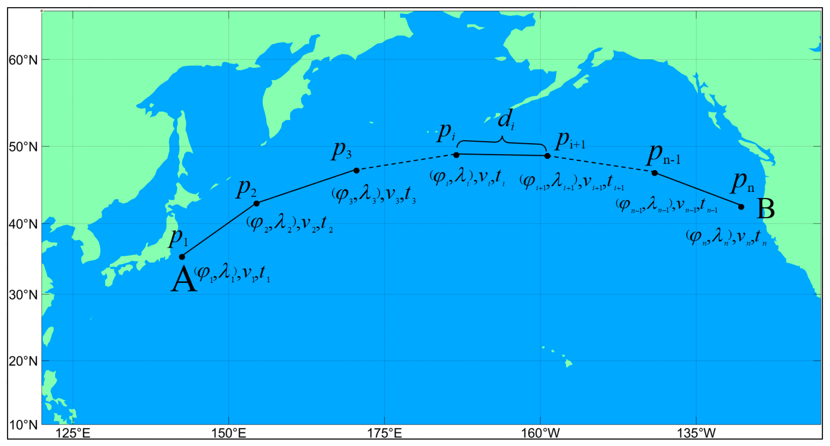
In the route-optimized design, the whole route is defined as a combination of multiple route points, that is, the route is divided into multiple route segments, each including latitude and longitude coordinates ( φ , λ ) and navigation speed v. The starting position and the end position as well as the departure time and arrival time are set. Route optimization is used to find the shortest and safest route. The route consists of n waypoints, which are represented as p = { p 1 , p 2 , , p n } , and the corresponding speed is represented by v = { v 1 , v 2 , , v n } , as shown in Figure 2.

2.2.2. Configuring Ship Speed

The external environment can have varying degrees of impact on the normal navigation of a ship in a complex and changing wind and wave environment. The ship will slow down if output power of the main engine remains constant, resulting in a lower actual speed than the still-water speed. This phenomenon is known as the natural speed loss of the ship. Of course, sometimes when the ship is sailing in bad sea conditions, the surrounding environment will pose a great threat to the safety of the ship route, and the captain will take the initiative to reduce the speed of the ship to ensure safe driving and avoid accidents. In ensuring safe running of the ship, reasonable planning of speed can make the ship sail at a suitable speed in different sea areas and achieve good operational benefits throughout the voyage. Under normal circumstances, the speed of a ship will be adjusted according to its own performance, navigation environment, and economic benefits, so as to keep it in a reasonable range, that is, the still-water speed v . To better study the influence of wind and waves on ship navigation, this paper assumes that the output power of the main engine of the ship is constant.
According to the empirical formula of Kwon [29], the speed loss of the ship can be shown as Equation (2):
Δ v = v i × C β C U C F o r m 100
Therefore, v i represents the actual speed of the ship during navigation, and the ship water speed v w i minus the speed loss Δ v is obtained, as shown in Equation (3):
v i = v w i Δ v
However, the speed loss of ships during actual navigation is affected by factors such as the marine meteorological environment and ship performance. Specific factors are shown in Table 1, Table 2 and Table 3 [30]. Here, C β represents the speed loss direction coefficient, which depends on the angle of direction of the weather and the value of the puff wind level, as shown in Table 1; C U represents the deceleration coefficient, which varies with the blocking coefficient CB, the load condition, and the Froude number F n , as shown in Table 2; C F o r m represents the shape coefficient of the hull, which is related to the ship type, wind level, and ship displacement (m3), as shown in Table 3.

3. Multi-Objective Route Optimization Model of the Ship

3.1. Objective Functions

In addition to the need to ensure the safety of navigation, a voyage must also consider the economic benefits of shipping, such as the amount of time it takes and how much fuel is used, in addition to ensuring the safety of the route. Therefore, ship route optimization is a complex problem involving multiple objectives, variables, and factors. The impact of sudden situations such as gusts is not taken into account by meteorological conditions to simplify the problem and facilitate the establishment and resolution of the model. The mathematical expression of the multi-objective route optimization model is as follows:
min F ( x ) = [ f 1 ( x ) , f 2 ( x ) ] T
x = [ p 1 , p 2 , , p n , v 1 , v 2 , , v n ] T
f 1 ( x ) = i = 1 n d i v w i
f 2 ( x ) = i = 1 n d i v w i × η ( v i )
v min v w i v max , i = 1 , 2 , , n
Here, x is the decision variable represented by the set of waypoints p and the corresponding actual speed v i ; n is the number of waypoints on the route. F ( ) are the objective functions, where f 1 ( ) is the total time of n leglines by the ship along the route, and f 2 ( ) is the total fuel consumption of the ship during navigation, which is related to the speed of the ship in still water. d i is the distance between waypoints i and i + 1 , v w i is the still water speed of a ship sailing between waypoints i and i + 1 , v min is the minimum speed, v max is the maximum speed, and η is the fuel consumption rate determined by the performance of the main engine of the ship and the speed, in which the baseline fuel consumption of the ship can be obtained by using the Lagrange method based on a large number of voyage data of the ship.
During the voyage, ships will encounter shoals, reefs, and other obstacles, which greatly limit the scope of ship activities. Therefore, in the optimization process, it is necessary to stay as far away from them as possible. Equation (9) represents the geographical constraints of the ship in navigation:
D ( p i )   >   D d r a f t + D u k c , i = 1 , 2 , , n 1
where D ( p i ) is the water depth of the ship at the i -th waypoint, and D d r a f t and D u k c respectively represent the average draft of the ship at this position and the gap under the keel.
During the voyage of the ship, under the combined action of external parameters such as wind, waves, and currents, the periodic change in the geometric shape of the immersed part of the hull and the shape of the waterline surface leads to the periodic change in the restoring moment of the ship, that is, the rolling phenomenon. This phenomenon can easily cause the ship to capsize and is a huge potential safety hazard. However, an important factor affecting rolling is the relationship between the encounter period and the natural period:
T n = 2 C × B h G M
T e = 2 π ω ω 2 g v cos χ
In Equation (10), C = 0.373 + 0.023 × B d 0.00043 L ; B is the width of the ship; L is the waterline length; d is the average water intake; and h G M is the height of initial stable center.
In Equation (11), χ = ψ μ is the encounter angle; ψ is the heading angle; μ is the absolute wave direction angle; ω is the natural frequency of waves; v is the ship speed; and g is the acceleration due to gravity.
1 τ 1 < T e T n < 1 + τ 1 , 1 τ 2 < 2 T e T n < 1 + τ 2 , 0.5 L p p λ 1.5 L p p
Equation (12) addresses the stability constraint of the ship in navigation, where τ 1 and τ 2 are the thresholds, taken here to be 0.5; L p p is the length of the ship; λ = 1.56 T 2 is the wave length of the wave; and T is the wave period. Equation (13) represents the constraints of weather or sea condition that the ship can withstand:
H w a v e ( p i ) H max , W w i n d ( p i ) W max , i = 1 , 2 , , n
These conditions are usually simply set to deterministic thresholds, such as maximum allowable wave height and maximum allowable wind speed. H and W represent the wave height and wind speed encountered by the ship at the i -th waypoint, which do not exceed the maximum allowable wave height H max and the maximum allowable wind speed W max .

3.2. Designing the Algorithm

By considering multiple objective functions and constraints at once, they can determine that a population approach is the most optimal solution in the feasible region. The behavior of organisms during evolution is simulated using natural selection, elimination, and reproduction mechanisms. Selecting a suitable multi-objective evolutionary algorithm (MOEA) is crucial to finding the optimal solution for the multi-objective and multi-constraint route optimization problem.
Currently, the non-dominated sorting genetic algorithm is a mature MOEA. It achieves efficient search, uniform distribution, and diversity maintenance of solutions through fast non-dominated sorting, congestion comparison, and elite strategy, and has high convergence and robustness. Compared to other algorithms, the NSGA-II is more stable and efficient, so it is chosen to solve the multi-objective route optimization problem.
In the MOEA, the initial population is randomly generated in the solution space, and the characteristics of individuals are represented by chromosomes, and then the population is updated by crossover, mutation, and selection. Similarly, when solving the multi-objective route optimization problem, the individual ship route can be composed of variables determined by waypoints and speed information, as shown in Equation (14):
I N = [ p 1 , p 2 , p N , v 1 , v 2 , , v N ] T , N = 1 , 2 , N
where p 1 and p N are the departure position and destination position, respectively; and N is the number of individuals in the population.
In order to improve the calculation speed and accuracy of the algorithm, the initial population is generated randomly, that is, the routes around the great circle empirical routes are randomly generated as individual populations, and the navigation speed is also generated randomly. A new population Q0 is generated by selecting, crossing, and mutating the initial population I0 to ensure that the population sizes of I0 and Q0 are both N. It and Qt are merged into Ct, and after the Ct is quickly non-dominated, a partial ordered set is established by calculating the crowding distance of all individuals in a certain self, and then individuals are selected in turn to enter It+1 until the scale reaches N. Then, an iterative operation is performed to determine if the maximum number of iterations is satisfied. If not, the new generation of population Qt+1 is continued to be generated. If it is satisfied, the individual of It+1 is output, that is, the non-dominated optimal solution set.
Route optimization is an optimization problem to find the minimum value of the objective function; the smaller the value, the better the individual’s fitness and survival probability. In the process of population evolution, a penalty factor ζ is added to the objective function to evaluate the fitness of the individual. The individual increases the elimination rate of the next generation by increasing the value of the cost function, but the individual can evolve through operations such as cross mutation, which not only ensures the randomness of the individual, but also improves the efficiency of algorithm optimization. As shown in Equation (15):
F ( I N ) = f j ( I N ) × ζ , j = 1 , 2
It is worth noting that the NSGA-II algorithm’s discovery of the Pareto solution set is not the only optimal solution. Therefore, solving the route optimization problem by evolutionary algorithm is to find a set of solution sets that make the objective function more complementary, and then sort the solution sets according to the user’s optimization criteria based on sorting method, and finally obtain the optimal route.

4. Experiment Analysis

4.1. Data Acquisition

Sea conditions and weather factors such as significant wave height (SWH), mean sea level pressure (MSLP), 10 m U-component of wind (U10), 10 m V-component of wind (V10), mean period of wind waves (MPWW), mean wave direction (MWD), and effective height of wind waves (SHWW) are obtained from the ECMWF. The meteorological data are stored in NetCDF format, with a grid resolution of 1 × 1.
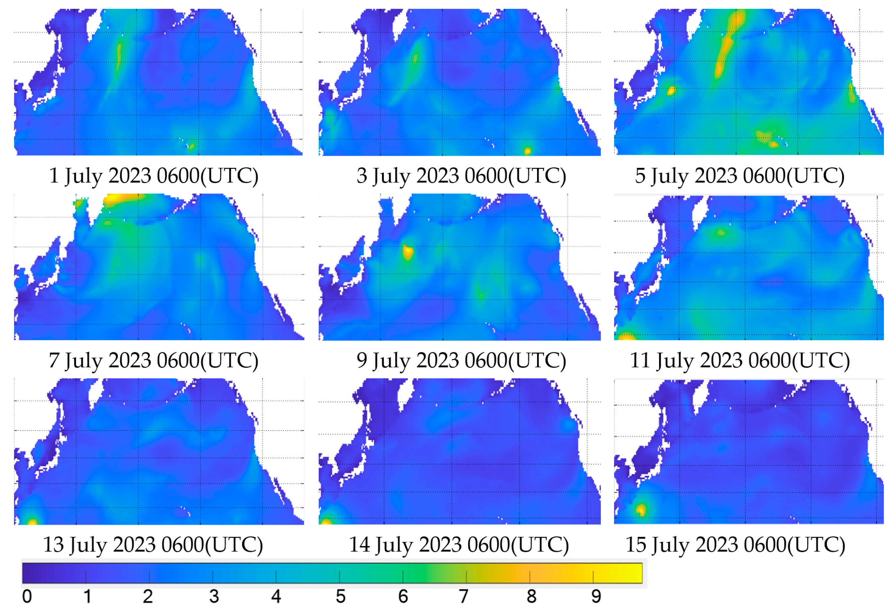
Historical weather data from of the Pacific Ocean were selected as the input of the simulated environmental data. In order to make the experimental ship sail closer to the actual navigation environment, the environment data were updated every 1 h and re-entered into the model. Figure 3 and Figure 4 show part of the data visualization.

4.2. Route Optimization Experiment

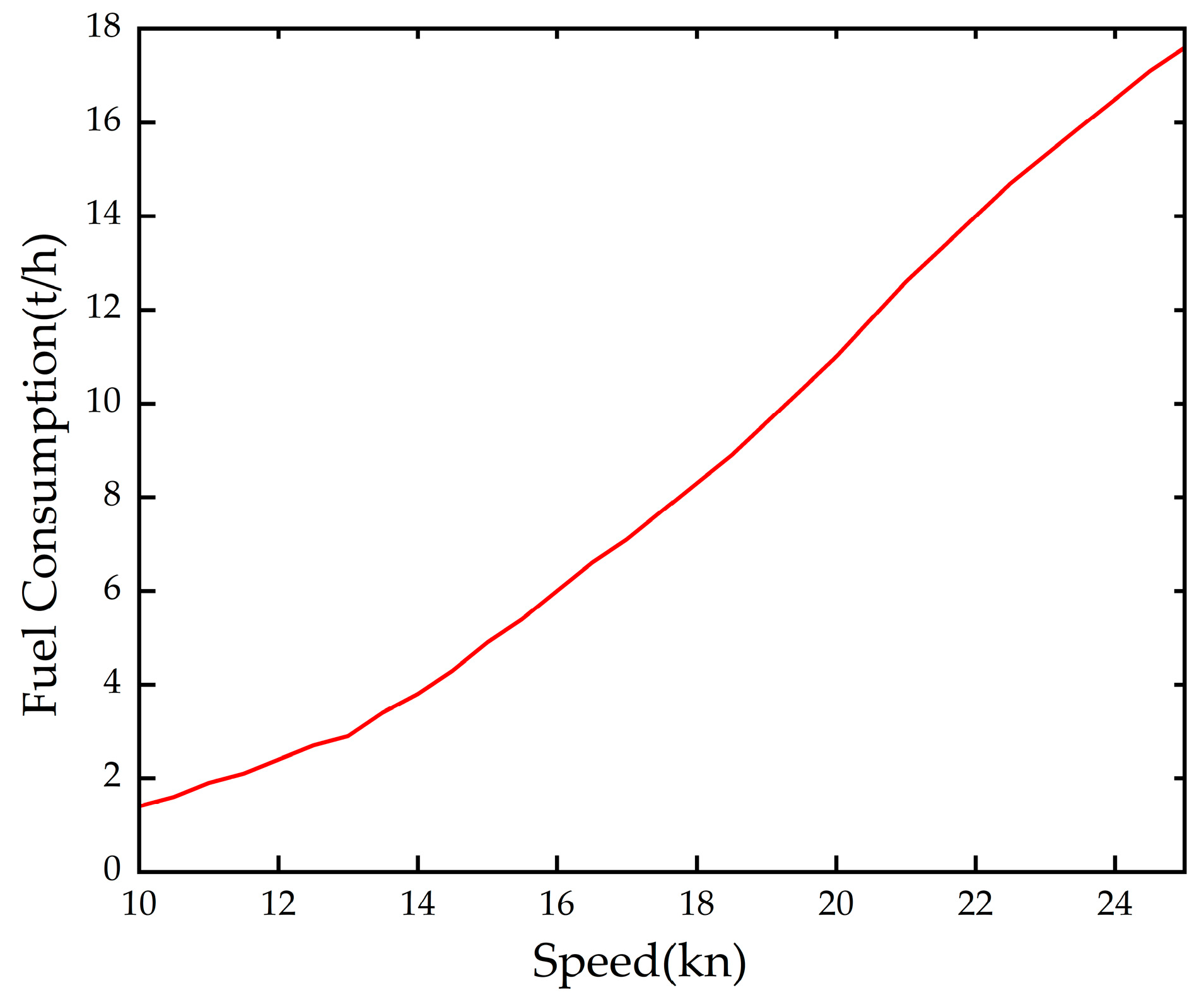
To verify the feasibility of the route optimization method proposed in this paper, bad weather conditions are simulated. In the experiment, the Pacific Ocean is selected as the navigation area, starting from Yokohama Port in Japan and ending at San Francisco Port in the United States, and the weather forecast data in July 2023 is selected as the navigation condition of the ship [31,32,33]. In addition, a typical container ship is simulated in the route optimization. The relevant parameters of the ship are shown in Table 4, and the speed of the ship is set to 12–20 knots. In this experiment, waves with heights higher than 6m are considered dangerous sea conditions. Based on the traditional speed fuel consumption table method this paper adopts the Lagrange interpolation polynomial fuel consumption baseline as shown in Figure 5.
In this experiment, in order to verify the feasibility of the proposed route optimization model in bad weather, this experiment adopts three methods for route planning and compares them under the same navigation conditions. The Great Circle Route is the shortest route between two points on the sphere, that is, in the ideal environment, the ship will take the Great Circle Route as the best choice; in reality, however, the ship is not easy to sail along the Great Circle Route, and considering the dangerous meteorological environment, the route will be adjusted. Therefore, three kinds of route planning are adopted to find the optimal route, including the Great Circle Route, the GA Optimization Method, and the NSGA-II Optimization Route, which are the classic ship routes. Figure 6a,b show the convergence rate of the genetic algorithm and Pareto solution set of the NSGA-II, respectively. Figure 6a uses a single-objective genetic algorithm with weights.
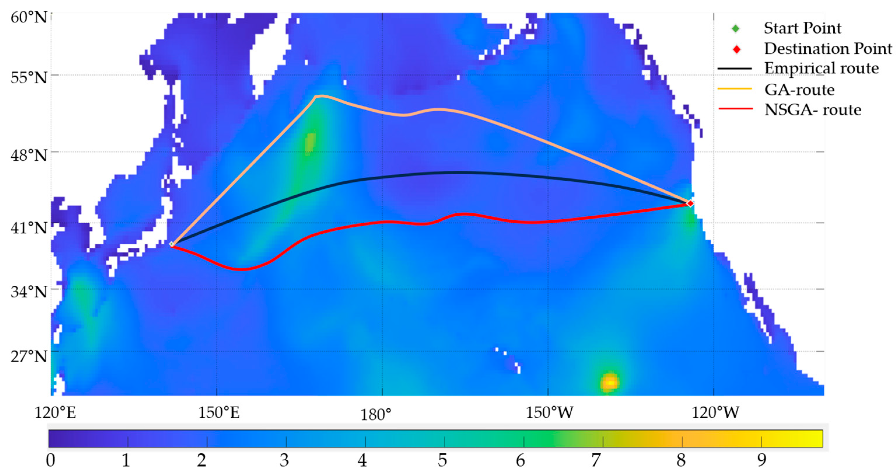
In the simulation experiment, the speed of the experimental ship is 15 knots, which is the speed of the circular route, that is, the speed of the empirical route. The speed of the other two optimized routes is calculated according to the speed loss calculation formula. Table 5 shows the parameter settings of the two methods. In the case of the same ship navigation environment, the routes obtained by the two optimization methods are compared with the classic routes. Table 6 shows the route information obtained by different methods. Figure 7 shows the optimal path optimized by the two algorithms.
As can be seen from Figure 7 and Table 6, the Great Circle Route obviously encounters waves higher than 6 m in the course of sailing, and the voyage is very risky. The route obtained by the multi-objective evolutionary method can avoid the dangerous sea state area, and a route with the lowest fuel consumption can be found within the given constraints. However, although the GA route avoids the dangerous area, it has a higher fuel consumption and takes longer. As for the route optimization method in complex weather, the voyage is 101.23 nautical miles longer than the voyage along the Great Circle Route, because it detours a certain distance to avoid bad weather. However, it can be clearly seen from the table that the fuel consumption of the route planned by the method proposed in this paper is 92.24 t (6.94%) less than that of the Great Circle Route, making it an economical and safe route.
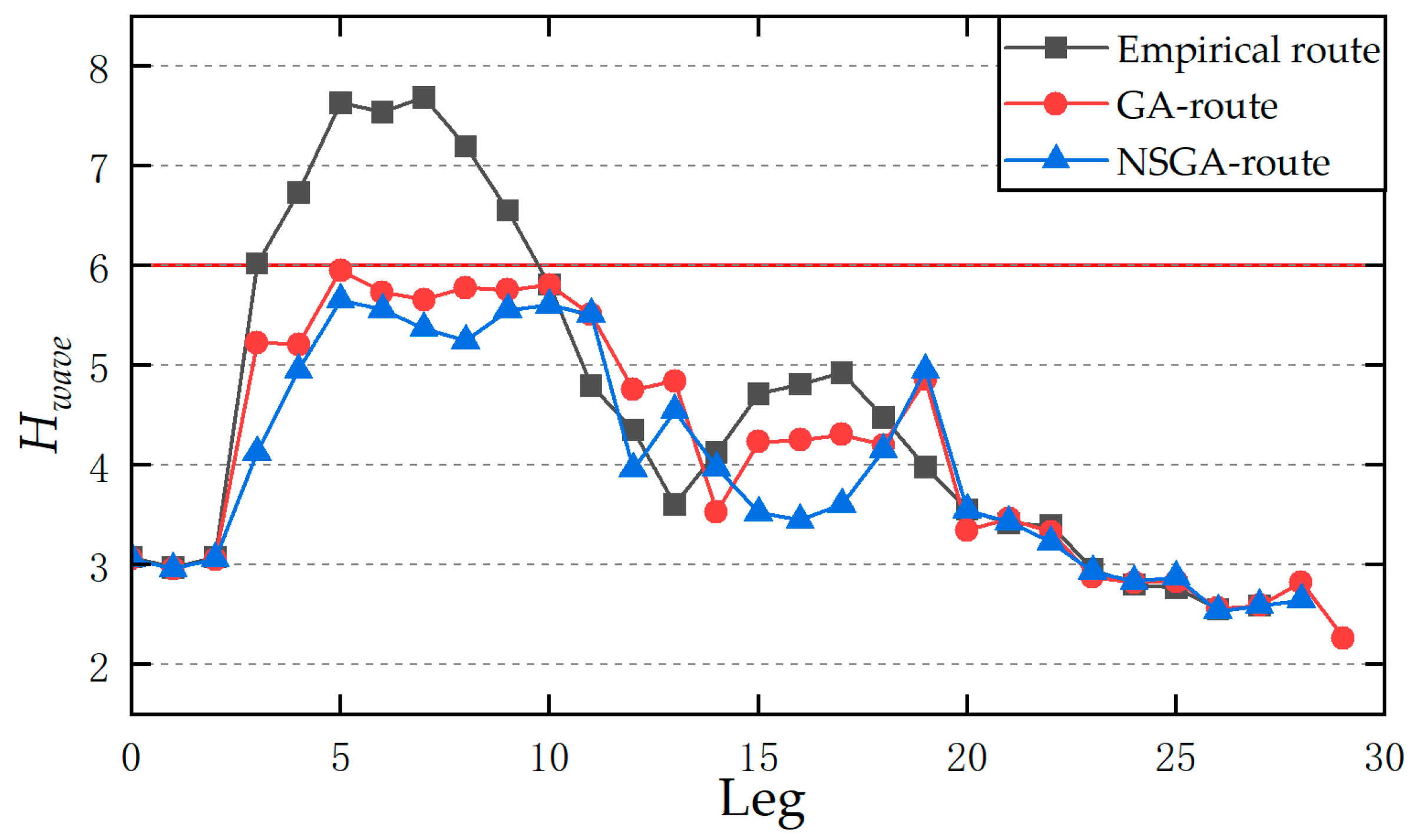
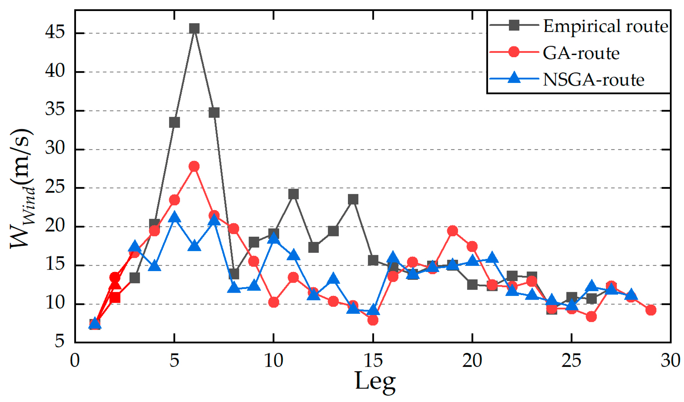
Figure 8 shows the significant wave heights experienced by the three routes at different time and space positions; the red solid line represents the maximum allowable significant wave height (H = 6 m). From Figure 8, it can be found that during the period of segment 4–10, the wave height of the empirical route exceeds the allowable wave height limit, even exceeding 7 m. Therefore, there is a great risk in following the empirical route; in contrast, the other two optimized routes can avoid the high wind and wave area and rationally allocate the speed. Figure 9 shows the wind speed of the three routes at different time and space positions. It can be seen that the wind field of the two optimized routes is stable and safe compared with the Great Circle Route. Compared to the GA route, the NSGA route has the characteristics of short time consumption and low energy consumption.

5. Conclusions

Ship navigation is forced to slow down or detour due to the influence of high wind and wave environment to ensure the safety of navigation, which will lead to increased shipping costs and increased risks. In order to find a safe and energy-saving green route within the specified time, this paper proposes a multi-objective route optimization method under a complex marine environment. Firstly, this paper rasterizes the marine environment information, establishes a complex marine environment model, and updates the model based on meteorological data. Taking the navigation position and speed as the decision variables, considering the influence of the marine environment on the ship’s motion, the technical characteristics, and stability of the ship, the NSGA is used to find the optimal route. Through case analysis (Section 4), the proposed method is superior to the widely used genetic algorithm. It is worth noting that there are still some shortcomings in the route-optimization design method proposed in this paper, which need to be solved in future work. The main reason is that the environmental modeling in this paper only considers the influence of wind and waves on navigation, and there is a certain gap with the actual environment of maritime navigation. Therefore, it is necessary to consider comprehensive and more accurate weather data that affect the navigation status. In the future, a method of ship navigation safety assessment can be introduced to improve the accuracy of route optimization.

Author Contributions

Conceptualization, S.Z. (Shuling Zhao); methodology, S.Z. (Shuling Zhao) and S.Z. (Sishuo Zhao); writing—original draft preparation, S.Z. (Sishuo Zhao); writing—review and editing, S.Z. (Shuling Zhao) and S.Z. (Sishuo Zhao), funding acquisition, S.Z. (Shuling Zhao) All authors have read and agreed to the published version of the manuscript.

Funding

This work was jointly supported by the National Natural Science Foundation of China (72061016).

Institutional Review Board Statement

Not applicable.

Informed Consent Statement

Not applicable.

Data Availability Statement

The data can be accessed by sending an email to the corresponding author.

Conflicts of Interest

The authors declare no conflicts of interest.

References

  1. Bullock, S.; Mason, J.; Broderick, J.; Larkin, A. Shipping and the Paris climate agreement: A focus on committed emissions. BMC Energy 2020, 2, 5. [Google Scholar] [CrossRef]
  2. Müller-Casseres, E.; Edelenbosch, O.Y.; Szklo, A.; Schaeffer, R.; van Vuuren, D.P. Global futures of trade impacting the challenge to decarbonize the international shipping sector. Energy 2021, 237, 121547. [Google Scholar] [CrossRef]
  3. Chen, X.; Liu, S.; Liu, R.W.; Wu, H.; Han, B.; Zhao, J. Quantifying Arctic oil spilling event risk by integrating an analytic network process and a fuzzy comprehensive evaluation model. Ocean. Coast. Manag. 2022, 228, 106326. [Google Scholar] [CrossRef]
  4. Wu, G.; Atilla, I.; Tahsin, T.; Terziev, M.; Wang, L. Long-voyage route planning method based on multi-scale visibility graph for autonomous ships. Ocean Eng. 2021, 219, 108242. [Google Scholar] [CrossRef]
  5. Seo, C.; Noh, Y.; Abebe, M. Ship collision avoidance route planning using CRI-based A∗ algorithm. Int. J. Nav. Archit. Ocean. Eng. 2023, 15, 100551. [Google Scholar] [CrossRef]
  6. Silveira, P.; Teixeira, A.P.; Guedes-Soares, C. AIS based shipping routes using the Dijkstra algorithm. TransNav Int. J. Mar. Navig. Saf. Sea Transp. 2019, 13, 565–571. [Google Scholar] [CrossRef]
  7. Wang, H.; Mao, W.; Eriksson, L. A Three-Dimensional Dijkstra’s algorithm for multi-objective ship voyage optimization. Ocean Eng. 2019, 186, 106131. [Google Scholar] [CrossRef]
  8. Liu, Y.; Wang, T.; Xu, H. PE-A* Algorithm for Ship Route Planning Based on Field Theory. IEEE Access 2022, 10, 36490–36504. [Google Scholar] [CrossRef]
  9. Shin, Y.W.; Abebe, M.; Noh, Y.; Lee, S.; Lee, I.; Kim, D.; Bae, J.; Kim, K.C. Near-Optimal Weather Routing by Using Improved A* Algorithm. Appl. Sci. 2020, 10, 6010. [Google Scholar] [CrossRef]
  10. Mannarini, G.; Subramani, D.N.; Lermusiaux, P.F.; Pinardi, N. Graph-search and differential equations for time-optimal vessel route planning in dynamic ocean waves. IEEE Trans. Int. Trans. Syst. 2019, 21, 3581–3593. [Google Scholar] [CrossRef]
  11. Wang, L.; Zhang, Z.; Zhu, Q.; Ma, S. Ship route planning based on double-cycling genetic algorithm considering ship maneuverability constraint. IEEE Access 2020, 8, 190746–190759. [Google Scholar] [CrossRef]
  12. Goez, G.D.; Velasquez, R.A.; Botero, J.S. UAV route planning optimization using PSO implemented on microcontrollers. IEEE Lat. Am. Trans. 2016, 14, 1705–1710. [Google Scholar] [CrossRef]
  13. Zhou, P.; Zhou, Z.; Wang, Y.; Wang, H. Ship weather routing based on hybrid genetic algorithm under complicated sea conditions. J. Ocean Uni. China 2023, 22, 28–42. [Google Scholar] [CrossRef]
  14. Zhang, G.; Wang, H.; Zhao, W.; Guan, Z.; Li, P. Application of improved multi-objective ant colony optimization algorithm in ship weather routing. J. Ocean Uni. China 2021, 20, 45–55. [Google Scholar] [CrossRef]
  15. Svanberg, M.; Santén, V.; Hörteborn, A.; Holm, H.; Finnsgård, C. AIS in maritime research. Mar. Policy 2019, 106, 103520. [Google Scholar] [CrossRef]
  16. Liu, D.; Rong, H.; Soares, C.G. Shipping route modelling of AIS maritime traffic data at the approach to ports. Ocean Eng. 2023, 289, 115868. [Google Scholar] [CrossRef]
  17. Xiao, G.; Chen, L.; Chen, X.; Jiang, C.; Ni, A.; Zhang, C.; Zong, F. A hybrid visualization model for knowledge mapping: Scientometrics, SAOM, and SAO. IEEE Trans. Int. Trans. Syst. 2023. [Google Scholar] [CrossRef]
  18. Cai, J.; Chen, G.; Lützen, M.; Rytter, N.G.M. A practical AIS-based route library for voyage planning at the pre-fixture stage. Ocean Eng. 2021, 236, 109478. [Google Scholar] [CrossRef]
  19. Gao, X.; Dong, Y.; Han, Y. An Optimized Path Planning Method for Container Ships in Bohai Bay Based on Improved Deep Q-learning. IEEE Access 2023, 11, 91275–91292. [Google Scholar] [CrossRef]
  20. Comert, S.E.; Yazgan, H.R. A new approach based on hybrid ant colony optimization-artificial bee colony algorithm for multi-objective electric vehicle routing problems. Eng. Appl. Artificial. Int. 2023, 123, 106375. [Google Scholar] [CrossRef]
  21. Chen, X.; Wang, M.; Ling, J.; Wu, H.; Wu, B.; Li, C. Ship imaging trajectory extraction via an aggregated you only look once (YOLO) model. Eng. Appl. Art. Int. 2024, 130, 107742. [Google Scholar] [CrossRef]
  22. Srivastava, G.; Singh, A.; Mallipeddi, R. NSGA-II with objective-specific variation operators for multiobjective vehicle routing problem with time windows. Expert Syst. Appl. 2021, 176, 114779. [Google Scholar] [CrossRef]
  23. Pingale, R.P.; Shinde, S.N. Multi-objective sunflower based grey wolf optimization algorithm for multipath routing in IoT network. Wirel. Pers. Commun. 2021, 117, 1909–1930. [Google Scholar] [CrossRef]
  24. Zhang, L.; Bienkowski, A.; Macesker, M.; Pattipati, K.R.; Sidoti, D.; Hansen, J.A. Many-Objective Maritime Path Planning for Dynamic and Uncertain Environments. In Proceedings of the 2021 IEEE Aerospace Conference (50100), Big Sky, MT, USA, 6–13 March 2021; pp. 1–10. [Google Scholar]
  25. Du, W.; Li, Y.; Zhang, G.; Wang, C.; Zhu, B.; Qiao, J. Ship weather routing optimization based on improved fractional order particle swarm optimization. Ocean Eng. 2022, 248, 110680. [Google Scholar] [CrossRef]
  26. Ma, W.; Lu, T.; Ma, D.; Wang, D.; Qu, F. Ship route and speed multi-objective optimization considering weather conditions and emission control area regulations. Mari Policy Manag. 2021, 48, 1053–1068. [Google Scholar] [CrossRef]
  27. Yuan, Q.; Wang, S.; Zhao, J. Uncertainty-informed ship voyage optimization approach for exploiting safety, energy saving and low carbon routes. Ocean Eng. 2022, 266, 112887. [Google Scholar] [CrossRef]
  28. Szlapczynski, R.; Szlapczynska, J.; Vettor, R. Ship weather routing featuring w-MOEA/D and uncertainty handling. Appl. Soft Computing. 2023, 138, 110142. [Google Scholar] [CrossRef]
  29. Kwon, Y.J. Speed loss due to added resistance in wind and waves. Nav. Archit. 2008, 3, 14–16. [Google Scholar]
  30. Lu, R.; Turan, O.; Boulougouris, E.; Banks, C.; Incecik, A. A semi-empirical ship operational performance prediction model for voyage optimization towards energy efficient shipping. Ocean Eng. 2015, 110, 18–28. [Google Scholar] [CrossRef]
  31. Uyanık, T.; Karatuğ, Ç.; Arslanoğlu, Y. Machine learning approach to ship fuel consumption: A case of container vessel. Trans. Res. Part D Transport. Environ. 2020, 84, 102389. [Google Scholar] [CrossRef]
  32. Sang, Y.; Ding, Y.; Xu, J.; Sui, C. Ship voyage optimization based on fuel consumption under various operational conditions. Fuel 2023, 352, 129086. [Google Scholar] [CrossRef]
  33. Cepowski, T.; Drozd, A. Measurement-based relationships between container ship operating parameters and fuel consumption. Appl. Energy 2023, 347, 121315. [Google Scholar] [CrossRef]
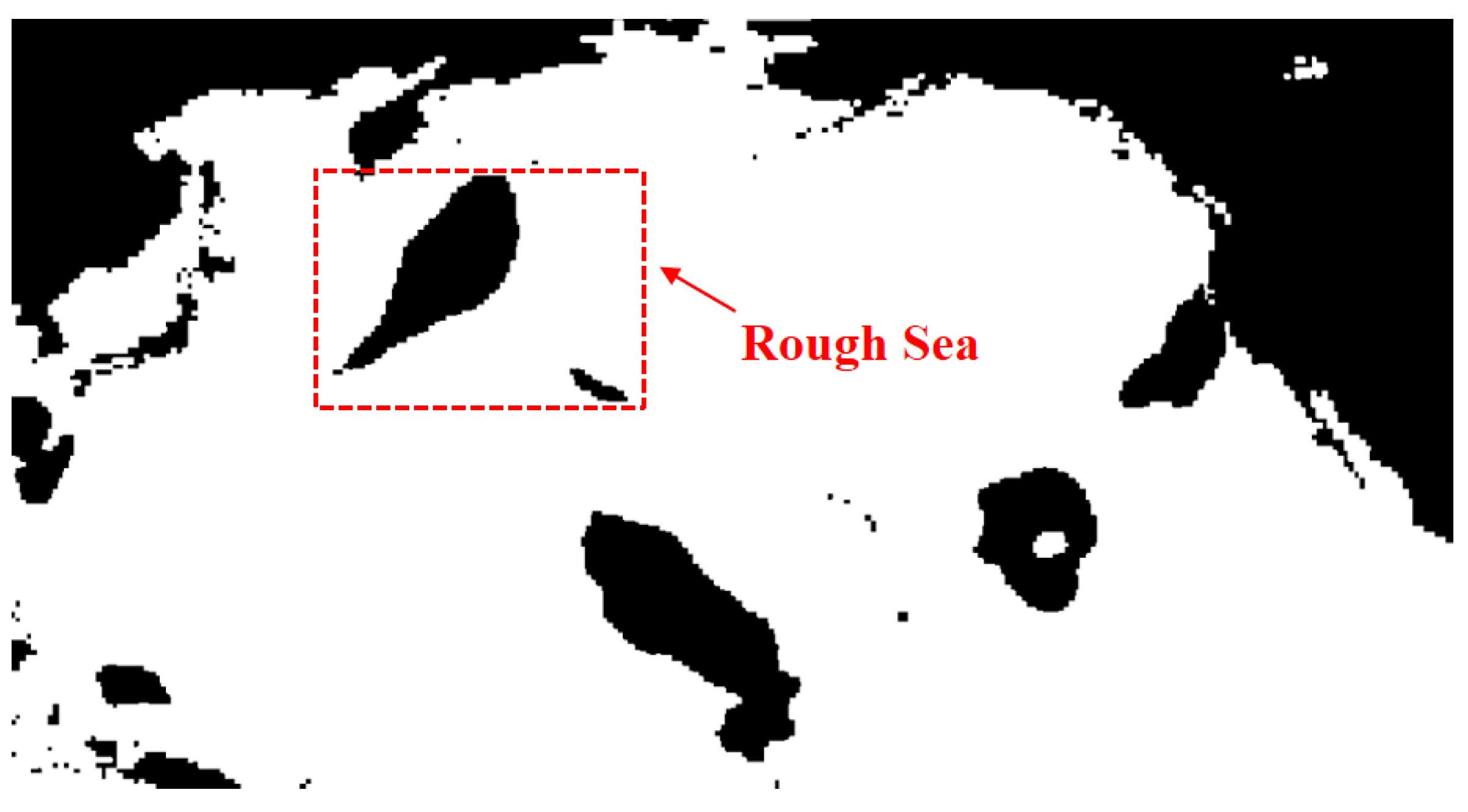
Figure 1. Sea state environment model.
Jmse 12 00485 g001
Figure 2. Route generation process.
Jmse 12 00485 g002
Figure 3. Wind field at different times (Pacific Ocean).
Jmse 12 00485 g003
Figure 4. Effective wave heights at different times (Pacific Ocean).
Jmse 12 00485 g004
Figure 5. Fuel consumption benchmark curve.
Jmse 12 00485 g005
Figure 6. (a) Convergence curve of the genetic algorithm (GA). (b) Pareto front solution set of the NSGA-II algorithm.
Jmse 12 00485 g006
Figure 7. Route trajectories obtained by different methods.
Jmse 12 00485 g007
Figure 8. Effective wave heights encountered in different routes.
Jmse 12 00485 g008
Figure 9. Wind speed encountered along different routes.
Jmse 12 00485 g009
Table 1. Speed loss direction coefficient C β .
Wave (Wind) DirectionDirection Angle β C β
Top wave, headwind 2 C β = 2
Oblique wave, facing wave30–60° 2 C β = 1.7 0.03 ( B N 4 ) 2
Transverse wave, crosswinds60–150° 2 C β = 0.9 0.06 ( B N 6 ) 2
Following seas, tailwind150–180° 2 C β = 0.4 0.03 ( B N 8 ) 2
Table 2. Deceleration coefficient C u .
Ship Blocking Coefficient CBShip Load Situation C u
0.55Normal 1.7 1.4 F n 7.4 ( F n ) 2
0.60Normal 2.2 2.5 F n 9.7 ( F n ) 2
0.65Normal 2.6 3.7 F n 11.6 ( F n ) 2
0.70Normal 3.1 5.3 F n 12.4 ( F n ) 2
0.75Full load or normal 2.4 10.6 F n 9.5 ( F n ) 2
0.80Full load or normal 2.6 13.1 F n 15.1 ( F n ) 2
0.85Full load or normal 3.1 18.7 F n 28.0 ( F n ) 2
Table 3. Hull shape coefficient C F o r m .
Ship Form C F o r m
Full load conditions of all ship types (except cargo ships) 0.5 B N + B N 6.5 / ( 2.7 2 / 3 )
Preloading conditions of all ship types (except cargo ships) 0.7 B N + B N 6.5 / ( 2.7 2 / 3 )
Normal loading of cargo ships 0.7 B N + B N 6.5 / ( 22.0 2 / 3 )
Table 4. Relevant parameters of experimental ship.
ParameterNumerical Value
Length/m348
Ship width/m51.2
Average draft/m13.5
Displacement/m3169,700
Ship blocking coefficient0.693
Initial metacentric height/m4
Table 5. Relevant parameters of evolutionary algorithms.
AlgorithmParameterValue
Genetic algorithmPopulation size50
Maximum number of iterations200
Penalty factor1 × 1010
Cross probability0.6
Mutation probability0.1
Step factor0.3
NSGA-IIPopulation size50
Iterations200
Penalty factor1 × 1010
Table 6. Comparison results of three routes.
RouteDistance/nmVoyage Time/hFuel Consumption/t
Empirical route4864.50324.31329.78
GA route5182.66341.71296.36
NSGA route4965.73334.21237.54
Disclaimer/Publisher’s Note: The statements, opinions and data contained in all publications are solely those of the individual author(s) and contributor(s) and not of MDPI and/or the editor(s). MDPI and/or the editor(s) disclaim responsibility for any injury to people or property resulting from any ideas, methods, instructions or products referred to in the content.