
The Inversion of Three-Dimensional Ocean Temperature and Salinity Fields for the Assimilation of Satellite Observations
Abstract
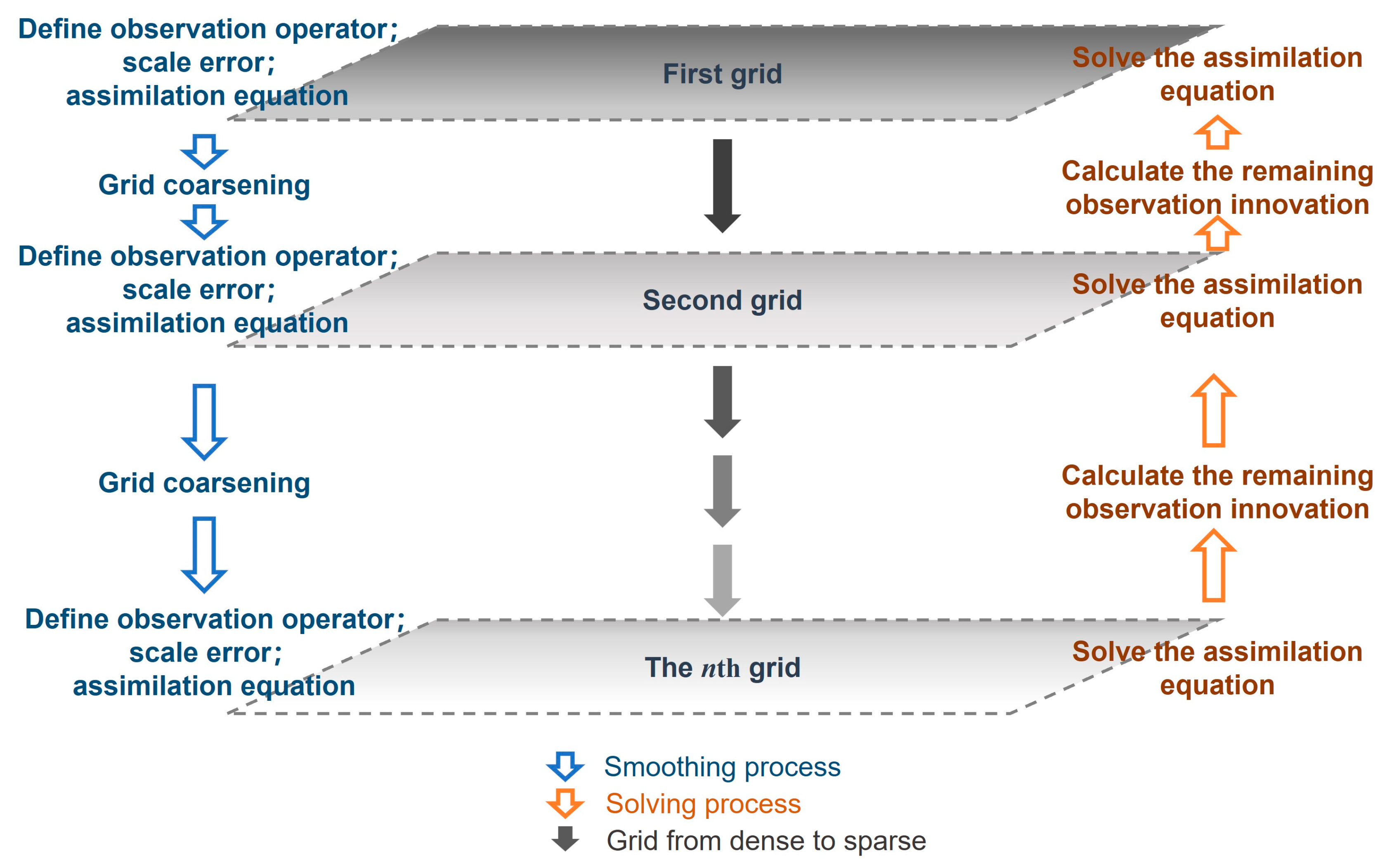
:1. Introduction
2. Methods
2.1. TSI-Net
2.2. Training Method
2.3. Integration of Pseudo-Observation Cost Functions
3. Sensitivity Analysis of Multi-Factor Inversion
3.1. Data Sources and Experimental Schemes
3.2. Correlation Factor Test for Temperature Inversion
3.3. Correlation Factor Test for Salinity Inversion
4. Discussion of Pseudo-Observational Assimilation Results
4.1. Analytical Field Evaluation of Temperature
4.2. Analytical Field Evaluation of Salinity
4.3. General Discussion
5. Conclusions
Author Contributions
Funding
Institutional Review Board Statement
Informed Consent Statement
Data Availability Statement
Acknowledgments
Conflicts of Interest
Appendix A


References
- Barth, A.; Alvera-Azcárate, A.; Weisberg, R.H. Assimilation of High-Frequency Radar Currents in a Nested Model of the West Florida Shelf. J. Geophys. Res. 2008, 113, C08033. [Google Scholar] [CrossRef]
- Miyoshi, T.; Kalnay, E.; Li, H. Estimating and Including Observation-Error Correlations in Data Assimilation. Inverse Probl. Sci. Eng. 2013, 21, 387–398. [Google Scholar] [CrossRef]
- Guinehut, S.; Dhomps, A.-L.; Larnicol, G.; Le Traon, P.-Y. High Resolution 3-D Temperature and Salinity Fields Derived from in Situ and Satellite Observations. Ocean Sci. 2012, 8, 845–857. [Google Scholar] [CrossRef]
- Chao, Y.; Li, Z.; Farrara, J.D.; Hung, P. Blending Sea Surface Temperatures from Multiple Satellites and In Situ Observations for Coastal Oceans. J. Atmos. Ocean. Technol. 2009, 26, 1415–1426. [Google Scholar] [CrossRef]
- Oke, P.R.; Chamberlain, M.A.; Fiedler, R.A.S.; Bastos de Oliveira, H.; Beggs, H.M.; Brassington, G.B. Combining Argo and Satellite Data Using Model-Derived Covariances: Blue Maps. Front. Earth Sci. 2021, 9, 696985. [Google Scholar] [CrossRef]
- Miyazawa, Y.; Varlamov, S.M.; Miyama, T.; Guo, X.; Hihara, T.; Kiyomatsu, K.; Kachi, M.; Kurihara, Y.; Murakami, H. Assimilation of High-Resolution Sea Surface Temperature Data into an Operational Nowcast/Forecast System around Japan Using a Multi-Scale Three-Dimensional Variational Scheme. Ocean. Dyn. 2017, 67, 713–728. [Google Scholar] [CrossRef]
- Xie, Y.; Koch, S.; McGinley, J.; Albers, S.; Bieringer, P.E.; Wolfson, M.; Chan, M. A Space–Time Multiscale Analysis System: A Sequential Variational Analysis Approach. Mon. Weather. Rev. 2011, 139, 1224–1240. [Google Scholar] [CrossRef]
- Han, G.; Li, W.; He, Z.; Liu, K.; Ma, J. Assimilated Tidal Results of Tide Gauge and TOPEX/POSEIDON Data over the China Seas Using a Variational Adjoint Approach with a Nonlinear Numerical Model. Adv. Atmos. Sci. 2006, 23, 449–460. [Google Scholar] [CrossRef]
- Killworth, P.D.; Dieterich, C.; Le Provost, C.; Oschlies, A.; Willebrand, J. Assimilation of Altimetric Data and Mean Sea Surface Height into an Eddy-Permitting Model of the North Atlantic. Prog. Oceanogr. 2001, 48, 313–335. [Google Scholar] [CrossRef]
- Li, Z.; McWilliams, J.C.; Ide, K.; Farrara, J.D. A Multiscale Variational Data Assimilation Scheme: Formulation and Illustration. Mon. Weather. Rev. 2015, 143, 3804–3822. [Google Scholar] [CrossRef]
- Li, Z.; Chao, Y.; McWilliams, J.C.; Ide, K. A Three-Dimensional Variational Data Assimilation Scheme for the Regional Ocean Modeling System: Implementation and Basic Experiments. J. Geophys. Res. 2008, 113, C05002. [Google Scholar] [CrossRef]
- He, Z.J.; Han, G.J.; Li, W.; Li, D.; Zhang, X.F.; Wang, X.D.; Wu, X.R. Experiments on assimilating of satellite data in the China seas and adjacent seas. Period. Ocean. Univ. China 2010, 40, 1–7. [Google Scholar] [CrossRef]
- Fox, D.N.; Teague, W.J.; Barron, C.N.; Carnes, M.R.; Lee, C.M. The Modular Ocean Data Assimilation System (MODAS)*. J. Atmos. Oceanic Technol. 2002, 19, 240–252. [Google Scholar] [CrossRef]
- Jeong, Y.; Hwang, J.; Park, J.; Jang, C.J.; Jo, Y.-H. Reconstructed 3-D Ocean Temperature Derived from Remotely Sensed Sea Surface Measurements for Mixed Layer Depth Analysis. Remote Sens. 2019, 11, 3018. [Google Scholar] [CrossRef]
- Su, H.; Wu, X.; Yan, X.-H.; Kidwell, A. Estimation of Subsurface Temperature Anomaly in the Indian Ocean during Recent Global Surface Warming Hiatus from Satellite Measurements: A Support Vector Machine Approach. Remote Sens. Environ. 2015, 160, 63–71. [Google Scholar] [CrossRef]
- Reichstein, M.; Camps-Valls, G.; Stevens, B.; Jung, M.; Denzler, J.; Carvalhais, N. Prabhat Deep Learning and Process Understanding for Data-Driven Earth System Science. Nature 2019, 566, 195–204. [Google Scholar] [CrossRef] [PubMed]
- Rong, Y.; Liang, X.S. An Information Flow-Based Sea Surface Height Reconstruction Through Machine Learning. IEEE Trans. Geosci. Remote Sens. 2022, 60, 4205909. [Google Scholar] [CrossRef]
- Liu, J.; Jin, B.; Wang, L.; Xu, L. Sea Surface Height Prediction With Deep Learning Based on Attention Mechanism. IEEE Geosci. Remote Sens. Lett. 2022, 19, 1501605. [Google Scholar] [CrossRef]
- Han, M.; Feng, Y.; Zhao, X.; Sun, C.; Hong, F.; Liu, C. A Convolutional Neural Network Using Surface Data to Predict Subsurface Temperatures in the Pacific Ocean. IEEE Access 2019, 7, 172816–172829. [Google Scholar] [CrossRef]
- Shao, Q.; Li, W.; Hou, G.; Han, G.; Wu, X. Mid-Term Simultaneous Spatiotemporal Prediction of Sea Surface Height Anomaly and Sea Surface Temperature Using Satellite Data in the South China Sea. IEEE Geosci. Remote Sens. Lett. 2022, 19, 1501705. [Google Scholar] [CrossRef]
- Shao, Q.; Li, W.; Han, G.; Hou, G.; Liu, S.; Gong, Y.; Qu, P. A Deep Learning Model for Forecasting Sea Surface Height Anomalies and Temperatures in the South China Sea. JGR Ocean. 2021, 126, e2021JC017515. [Google Scholar] [CrossRef]
- He, Z.; Wang, X.; Wu, X.; Chen, Z.; Chen, J. Projecting Three-Dimensional Ocean Thermohaline Structure in the North Indian Ocean From the Satellite Sea Surface Data Based on a Variational Method. JGR Ocean. 2021, 126, e2020JC016759. [Google Scholar] [CrossRef]
- Chandanpurkar, H.A.; Lee, T.; Wang, X.; Zhang, H.; Fournier, S.; Fenty, I.; Fukumori, I.; Menemenlis, D.; Piecuch, C.G.; Reager, J.T.; et al. Influence of Nonseasonal River Discharge on Sea Surface Salinity and Height. J. Adv. Model Earth Syst. 2022, 14, e2021MS002715. [Google Scholar] [CrossRef]
- Mao, K.; Liu, C.; Zhang, S.; Gao, F. Reconstructing Ocean Subsurface Temperature and Salinity from Sea Surface Information Based on Dual Path Convolutional Neural Networks. JMSE 2023, 11, 1030. [Google Scholar] [CrossRef]
- Hu, Y.; Zhang, X.; Li, D.; Li, W.; Zhang, L.; Fu, H.; Zhang, L. Anisotropic Diffusion Filters for Flow-Dependent Variational Data Assimilation of Sea Surface Temperature. Ocean. Model. 2023, 184, 102233. [Google Scholar] [CrossRef]
- Fernández, J.G.; Mehrkanoon, S. Broad-UNet: Multi-Scale Feature Learning for Nowcasting Tasks. Neural Netw. 2021, 144, 419–427. [Google Scholar] [CrossRef] [PubMed]
- Gao, Y.; Guan, J.; Zhang, F.; Wang, X.; Long, Z. Attention-Unet-Based Near-Real-Time Precipitation Estimation from Fengyun-4A Satellite Imageries. Remote Sens. 2022, 14, 2925. [Google Scholar] [CrossRef]
- Kingma, D.P.; Ba, J. Adam: A Method for Stochastic Optimization. arXiv 2017, arXiv:1412.6980. [Google Scholar]
- Li, W.; Xie, Y.; He, Z.; Han, G.; Liu, K.; Ma, J.; Li, D. Application of the Multigrid Data Assimilation Scheme to the China Seas’ Temperature Forecast. J. Atmos. Ocean. Technol. 2008, 25, 2106–2116. [Google Scholar] [CrossRef]
- Li, W.; Xie, Y.; Deng, S.-M.; Wang, Q. Application of the Multigrid Method to the Two-Dimensional Doppler Radar Radial Velocity Data Assimilation. J. Atmos. Ocean. Technol. 2010, 27, 319–332. [Google Scholar] [CrossRef]
- Jean-Michel, L.; Eric, G.; Romain, B.-B.; Gilles, G.; Angélique, M.; Marie, D.; Clément, B.; Mathieu, H.; Olivier, L.G.; Charly, R.; et al. The Copernicus Global 1/12° Oceanic and Sea Ice GLORYS12 Reanalysis. Front. Earth Sci. 2021, 9, 698876. [Google Scholar] [CrossRef]
- Good, S.A.; Martin, M.J.; Rayner, N.A. EN4: Quality Controlled Ocean Temperature and Salinity Profiles and Monthly Objective Analyses with Uncertainty Estimates. JGR Ocean. 2013, 118, 6704–6716. [Google Scholar] [CrossRef]


| Experiment Name | Factor Selection | Data Selection | Purpose of the Experiment |
|---|---|---|---|
| ExT1 | SST | Satellite observations of factors as single-channel inputs | Examining the effect of single-channel inversion of the temperature field |
| ExT2 | SST + SLA | Satellite observations of factors as two-channel inputs | Examining the effect of two-channel inversion of the temperature field |
| ExT3 | SST + SLA + SSS | Satellite observations of factors as three-channel inputs | Examining the effect of three-channel inversion of the temperature field |
| ExS1 | SSS | Satellite observations of factors as single-channel inputs | Examining the effect of single-channel inversion of the salinity field |
| ExS2 | SSS + SLA | Satellite observations of factors as two-channel inputs | Examining the effect of two-channel inversion of the salinity field |
| ExS3 | SSS + SLA + SST | Satellite observations of factors as three-channel inputs | Examining the effect of three-channel inversion of the salinity field |
| Metrics | Experiment Name | 20 m | 50 m | 100 m | 200 m |
|---|---|---|---|---|---|
| RMSE | ExT1 | 0.3652 | 1.1008 | 1.1178 | 0.5346 |
| ExT2 | 0.3518 | 0.5767 | 0.5787 | 0.2680 | |
| ExT3 | 0.3577 | 0.5557 | 0.5712 | 0.2668 | |
| R2 | ExT1 | 0.8989 | 0.8576 | 0.8209 | 0.7561 |
| ExT2 | 0.9003 | 0.8755 | 0.8373 | 0.7859 | |
| ExT3 | 0.9312 | 0.9102 | 0.8697 | 0.8154 |
| Metrics | Experiment Name | 20 m | 50 m | 100 m | 200 m |
|---|---|---|---|---|---|
| RMSE | ExS1 | 0.0696 | 0.0482 | 0.0158 | 0.0041 |
| ExS2 | 0.0679 | 0.0404 | 0.0138 | 0.0053 | |
| ExS3 | 0.0591 | 0.0385 | 0.0155 | 0.0091 | |
| R2 | ExS1 | 0.6616 | 0.4548 | 0.6955 | 0.7674 |
| ExS2 | 0.5979 | 0.4311 | 0.6554 | 0.7622 | |
| ExS3 | 0.6669 | 0.5367 | 0.6571 | 0.7467 |
Disclaimer/Publisher’s Note: The statements, opinions and data contained in all publications are solely those of the individual author(s) and contributor(s) and not of MDPI and/or the editor(s). MDPI and/or the editor(s) disclaim responsibility for any injury to people or property resulting from any ideas, methods, instructions or products referred to in the content. |
© 2024 by the authors. Licensee MDPI, Basel, Switzerland. This article is an open access article distributed under the terms and conditions of the Creative Commons Attribution (CC BY) license (https://creativecommons.org/licenses/by/4.0/).
Share and Cite
Zhao, Y.; He, Z.; Jiang, Y. The Inversion of Three-Dimensional Ocean Temperature and Salinity Fields for the Assimilation of Satellite Observations. J. Mar. Sci. Eng. 2024, 12, 534. https://doi.org/10.3390/jmse12040534
Zhao Y, He Z, Jiang Y. The Inversion of Three-Dimensional Ocean Temperature and Salinity Fields for the Assimilation of Satellite Observations. Journal of Marine Science and Engineering. 2024; 12(4):534. https://doi.org/10.3390/jmse12040534
Chicago/Turabian StyleZhao, Yueqi, Zhongjie He, and Yuhang Jiang. 2024. "The Inversion of Three-Dimensional Ocean Temperature and Salinity Fields for the Assimilation of Satellite Observations" Journal of Marine Science and Engineering 12, no. 4: 534. https://doi.org/10.3390/jmse12040534