
Circulation and Stratification Changes in a Hypersaline Estuary Due to Mean Sea Level Rise


Abstract
:1. Introduction
2. Study Region
3. Methodology
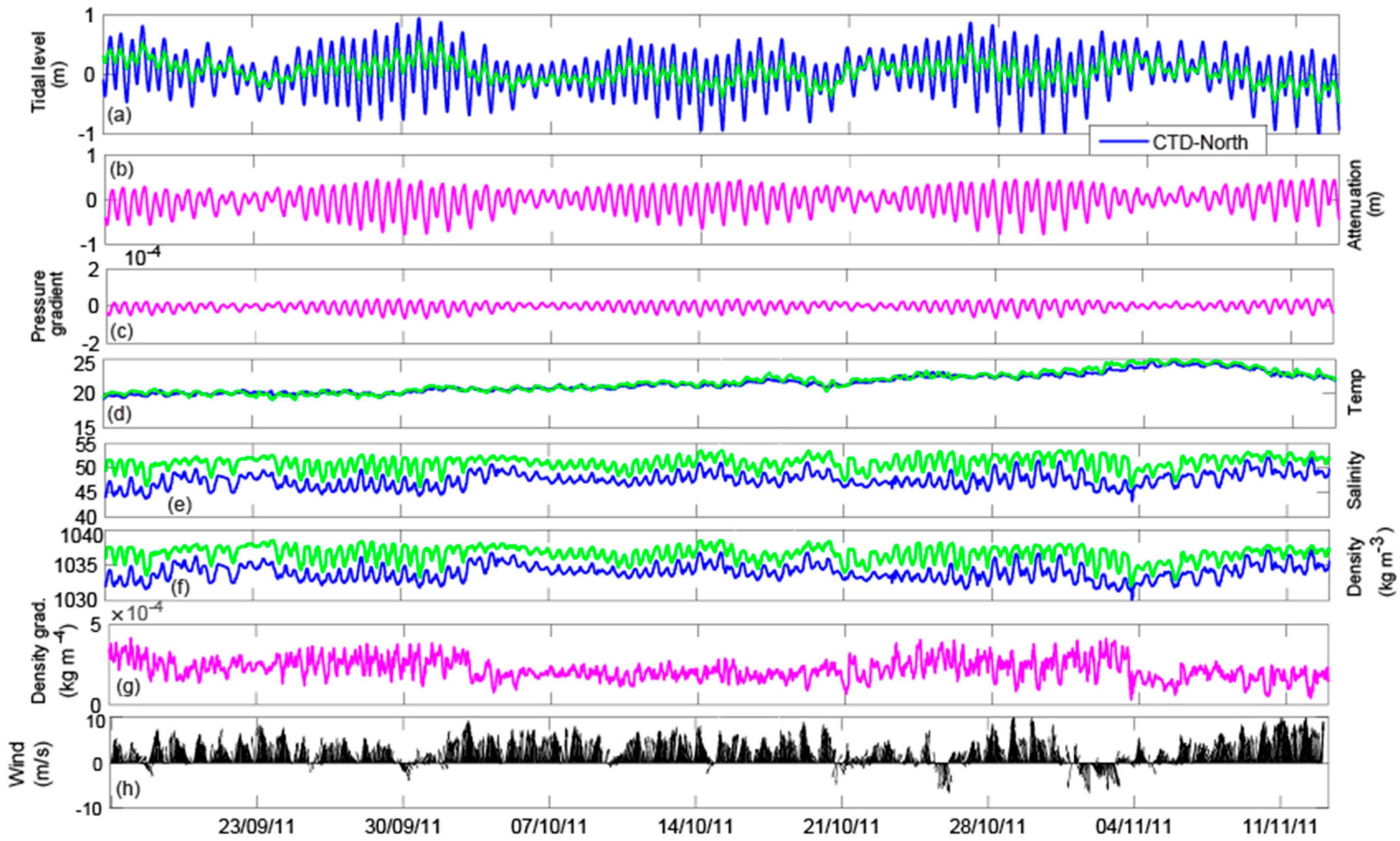
3.1. Field Data
3.2. Numerical Modelling
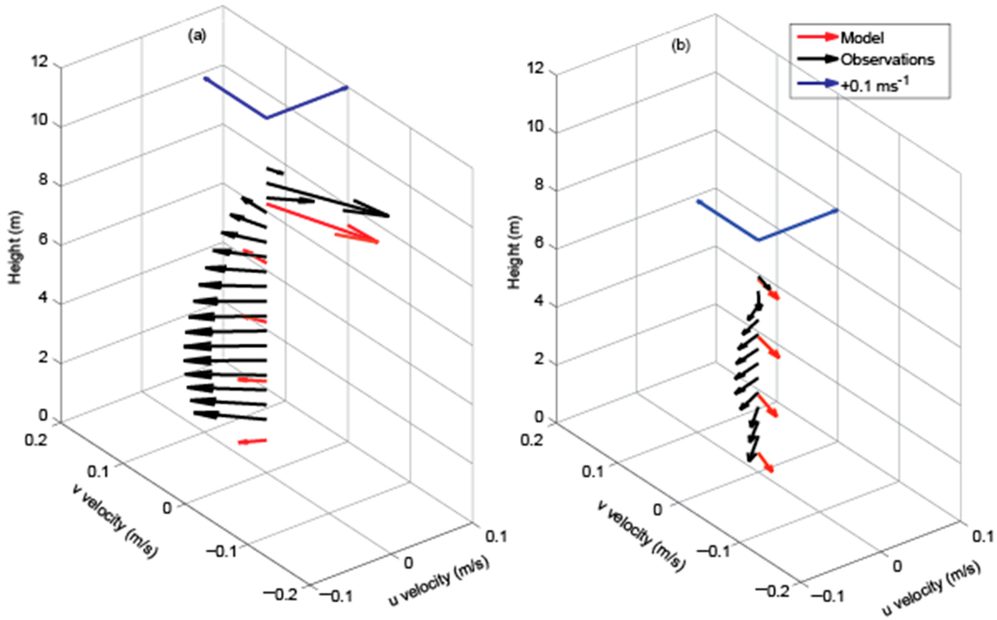
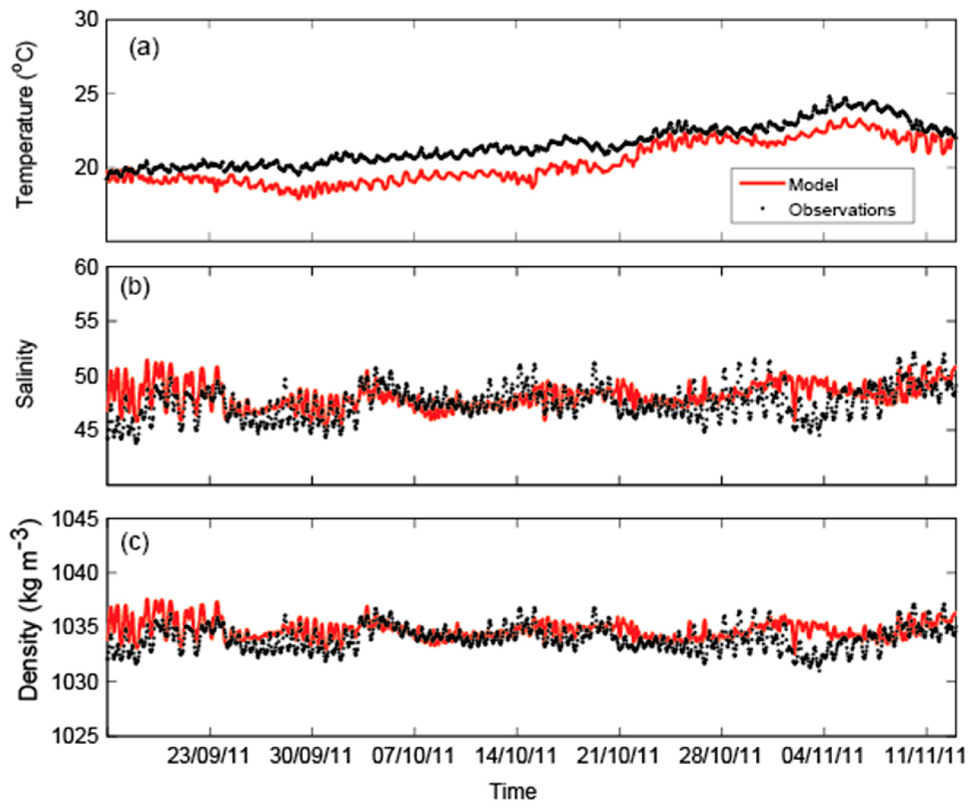
Model Performance
3.3. Vertical Mixing
4. Results
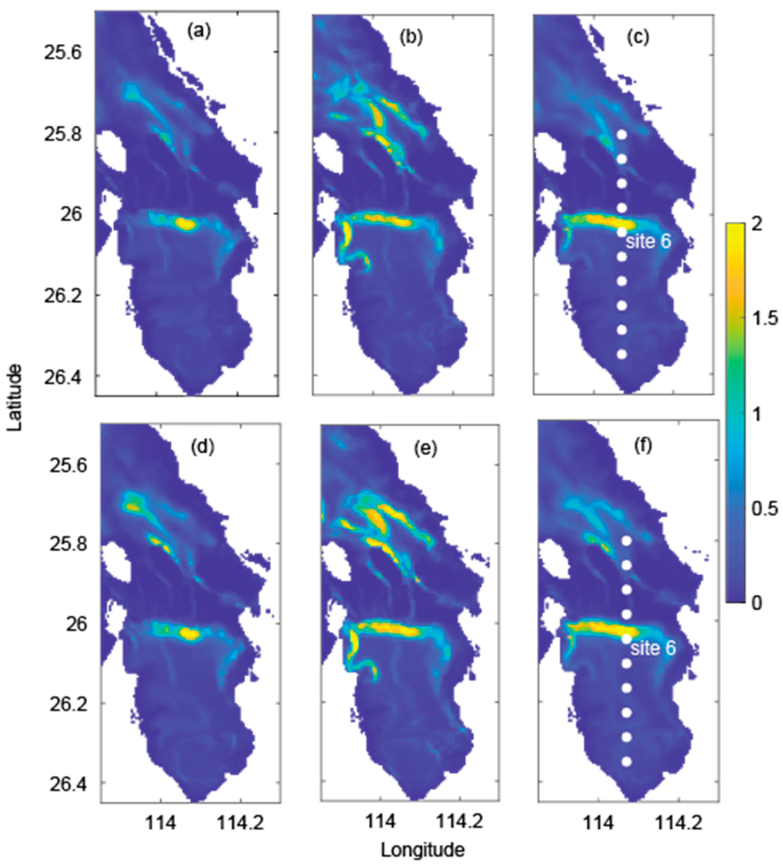
4.1. Present-Day Dynamics
4.2. Tidal Response to MSLR
4.3. Vertical Stratification
5. Discussion
5.1. Hydrodynamic Response to MSLR
5.2. Stratification Response to MSLR
5.3. Seagrass Response to MSLR
6. Conclusions
Author Contributions
Funding
Institutional Review Board Statement
Informed Consent Statement
Data Availability Statement
Acknowledgments
Conflicts of Interest
References
- Logan, B.W.; Cebulski, D.E. Sedimentary Environments of Shark Bay, Western Australia; American Association of Petroleum Geologists: Tulsa, Oklahoma, 1970. [Google Scholar]
- Burling, M.C.; Ivey, G.N.; Pattiaratchi, C.B. Convectively driven exchange in a shallow coastal embayment. Cont. Shelf Res. 1999, 19, 1599–1616. [Google Scholar] [CrossRef]
- Hetzel, Y.; Pattiaratchi, C.; Lowe, R. Intermittent dense water outflows under variable tidal forcing in Shark Bay, Western Australia. Cont. Shelf Res. 2013, 66, 36–48. [Google Scholar] [CrossRef]
- Hetzel, Y.; Pattiaratchi, C.B.; Mihanović, H. Exchange flow variability between hypersaline Shark Bay and the ocean. J. Mar. Sci. Eng. 2018, 6, 65. [Google Scholar] [CrossRef]
- Suosaari, E.P.; Reid, R.P.; Araujo, T.A.A.; Playford, P.E.; Holley, D.K.; Mcnamara, K.J. Environmental pressures influencing living stromatolites in Hamelin Pool, Shark Bay, Western Australia. Palaios 2016, 31, 483–496. [Google Scholar] [CrossRef]
- Morris, T.E.; Visscherb, P.T.; O’Leary, M.J.; Fearns, P.; Collins, L.B. The biogeomorphology of Shark Bay’s microbialite coasts. Earth-Sci. Rev. 2020, 205, 102921. [Google Scholar] [CrossRef]
- Jahnert, R.J.; Collins, L.B. Significance of subtidal microbial deposits in Shark Bay, Australia. Mar. Geol. 2011, 286, 106–111. [Google Scholar] [CrossRef]
- Jahnert, R.J.; Collins, L.B. Characteristics, distribution and morphogenesis of subtidal microbial systems in Shark Bay, Australia. Mar. Geol. 2012, 303–306, 115–136. [Google Scholar] [CrossRef]
- Kendrick, G.A.; Fourqurean, J.W.; Fraser, M.W.; Heithaus, M.R.; Jackson, G.; Friedman, K.; Hallac, D. Science behind management of Shark Bay and Florida Bay, two P-limited subtropical systems with different climatology and human pressures. Mar. Freshw. Res. 2012, 63, 941–951. [Google Scholar] [CrossRef]
- Largier, J. Low-inflow estuaries: Hypersaline, inverse, and thermal scenarios. In Contemporary Issues in Estuarine Physics; Valle-Levinson, A., Ed.; Cambridge University Press: Cambridge, UK, 2010; pp. 247–272. [Google Scholar]
- Nidzieko, N.J.; Monismith, S.G. Contrasting seasonal and fortnightly variations in the circulation of a seasonally-inverse estuary, Elkhorn Slough, California. Estuaries Coasts 2012, 36, 1–17. [Google Scholar] [CrossRef]
- Arulananthan, K.; Wijeratne, E.M.S.; Rydberg, L.; Cederlof, U. Water exchange in a hypersaline tropical estuary, the Puttalam Lagoon, Sri Lanka. Ambio 1995, 24, 438–443. [Google Scholar]
- Mudge, S.M.; Icely, J.D.; Newton, A. Residence times in a hypersaline lagoon: Using salinity as a tracer. Estuar. Coast. Shelf Sci. 2008, 77, 278–284. [Google Scholar] [CrossRef]
- De Velasco, G.G.; Winant, C.D. Wind- and density-driven circulation in a well-mixed inverse estuary. J. Phys. Oceanogr. 2004, 34, 1103–1116. [Google Scholar] [CrossRef]
- Bowers, D.G.; Lennon, G.W. Observations of stratified flow over a bottom gradient in a coastal sea. Cont. Shelf Res. 1987, 7, 1105–1121. [Google Scholar] [CrossRef]
- Nunes, R.; Lennon, G. Physical property distributions and seasonal trends in Spencer Gulf, South Australia: An inverse estuary. Mar. Freshw. Res. 1986, 37, 39–53. [Google Scholar] [CrossRef]
- Lavin, M.F.; Godinez, V.M.; Alvarez, L.G. Inverse-estuarine features of the Upper Gulf of California. Estuar. Coast. Shelf Sci. 1998, 47, 769. [Google Scholar] [CrossRef]
- Church, J.; White, N. Sea-Level Rise from the Late 19th to the Early 21st Century. Surv. Geophys. 2011, 32, 585–602. [Google Scholar] [CrossRef]
- Church, J.A.; Clark, P.U.; Cazenave, A.; Gregory, J.M.; Jevrejeva, S.; Levermann, A.; Merrifield, M.A.; Milne, G.A.; Nerem, R.S.; Nunn, P.D. Sea-Level Rise by 2100. Science 2013, 342, 1445. [Google Scholar] [CrossRef] [PubMed]
- Hoeke, R.K.; McInnes, K.L.; Kruger, J.C.; McNaught, R.J.; Hunter, J.R.; Smithers, S.G. Widespread inundation of Pacific islands triggered by distant-source wind-waves. Glob. Planet. Change 2013, 108, 128–138. [Google Scholar] [CrossRef]
- Storlazzi, C.D.; Elias, E.; Field, M.; Presto, M. Numerical modeling of the impact of sea-level rise on fringing coral reef hydrodynamics and sediment transport. Coral Reefs 2011, 30, 83–96. [Google Scholar] [CrossRef]
- Taebi, S.; Pattiaratchi, C.B. Hydrodynamic response of a fringing coral reef to a rise in mean sea level. Ocean. Dyn. 2014, 64, 975–987. [Google Scholar] [CrossRef]
- Shapiro, G.I.; Huthnance, J.M.; Ivanov, V.V. Dense water cascading off the continental shelf. J. Geophys. Res. Ocean. 2003, 108, 3390. [Google Scholar] [CrossRef]
- James, N.P.; Collins, L.B.; Hallock, P.; Bone, Y. Subtropical carbonates in a temperate realm: Modern sediments on the Southwest Australian Shelf. J. Sediment. Res. 1999, 69, 1297–1321. [Google Scholar] [CrossRef]
- Nahas, E.L.; Jackson, G.; Pattiaratchi, C.B.; Ivey, G.N. Hydrodynamic modelling of snapper Pagrus auratus egg and larval dispersal in Shark Bay, Western Australia: Reproductive isolation at a fine spatial scale. Mar. Ecol. Prog. Ser. 2003, 265, 213–226. [Google Scholar] [CrossRef]
- Pattiaratchi, C.B. Coastal tide gauge observations: Dynamic processes present in the Fremantle record. In Operational Oceanography in the 21st Century; Schiller, A., Brassington, G.B., Eds.; Springer: Dordrecht, The Netherland, 2011; pp. 185–202. [Google Scholar]
- Burne, R.V.; Johnson, K. Sea-level variation and the zonation of microbialites in Hamelin Pool, Shark Bay, Western Australia. Mar. Freshw. Res. 2012, 63, 994–1004. [Google Scholar] [CrossRef]
- Burling, M.C.; Pattiaratchi, C.B.; Ivey, G.N. The tidal regime of Shark Bay, Western Australia. Estuar. Coast. Shelf Sci. 2003, 57, 725–735. [Google Scholar] [CrossRef]
- Pugh, D.T. Tides, Surges, and Mean Sea-Level; John Wiley & Sons: Chichester, UK, 1987. [Google Scholar]
- Defant, A. Ebb and Flow; the Tides of Earth, Air, and Water; University of Michigan Press: Ann Arbor, MI, USA, 1958; Volume 70. [Google Scholar]
- Simpson, J.H.; Hunter, J.R. Fronts in the Irish sea. Nature 1974, 250, 404–406. [Google Scholar] [CrossRef]
- Nahas, E.L.; Pattiaratchi, C.B.; Ivey, G.N. Processes controlling the position of frontal systems in Shark Bay, Western Australia. Estuar. Coast. Shelf Sci. 2005, 65, 463–474. [Google Scholar] [CrossRef]
- Simpson, J.H.; Crisp, D.J.; Hearn, C. The shelf-sea fronts: Implications of their existence and behaviour. Philosophical Transactions of the Royal Society of London. Ser. A Math. Phys. Sci. 1981, 302, 531–546. [Google Scholar]
- Danish Hydraulic Institute (DHI). MIKE 3 Flow Model FM. Hydrodynamic Module-User Guide; DHI: Horsholm, Denmark, 2014. [Google Scholar]
- Webster, M.; Petkovic, P. Australian bathymetry and topography grid, June 2005. Geosci. Aust. Rec. 2005, 12, 30. [Google Scholar]
- Egbert, G.D.; Erofeeva, S.Y. Efficient inverse modeling of barotropic ocean tides. J. Atmos. Ocean. Technol. 2002, 19, 183–204. [Google Scholar] [CrossRef]
- Kalnay, E.C.; Kanamitsu, M.; Kistler, R.; Collins, W.; Deaven, D.; Gandin, L.; Iredell, M.; Saha, S.; White, G.; Woollen, J.; et al. The NCEP/NCAR 40-year reanalysis project. Bull. Am. Meteorol. Soc. 1996, 77, 437–471. [Google Scholar] [CrossRef]
- Kistler, R.; Kalnay, E.; Collins, W.; Saha, S.; White, G.; Woollen, J.; Chelliah, M.; Ebisuzaki, W.; Kanamitsu, M.; Kousky, V.; et al. The NCEP-NCAR 50-year reanalysis: Monthly means CD-ROM and documentation. Bull. Am. Meteorol. Soc. 2001, 82, 247–268. [Google Scholar] [CrossRef]
- Beggs, H.; Zhong, A.; Warren, G.; Alves, O.; Pugh, T.; Pugh, T. RAMSSA-an operational, high-resolution, regional Australian multi-sensor sea surface temperature analysis over the Australian region. Aust. Meteorol. Oceanogr. J. 2011, 61, 1–22. [Google Scholar] [CrossRef]
- Bicknell, C. Sea Level Change in Western Australia: Application to Coastal Planning; Coastal Engineering Group, WA Department of Transport: Perth, Australia, 2010; p. 23. [Google Scholar]
- Willmott, C.J. On the evaluation of model performance in physical geography. In Spatial Statistics and Models; Gaile, G.L., Willmott, C.J., Eds.; Reidel Publishing Company: Dordrecht, The Netherland, 1984; pp. 443–460. [Google Scholar]
- Simpson, J.H.; Bowers, D. Models of stratification and frontal movement in shelf seas. Deep Sea Res. Part A Oceanogr. Res. Pap. 1981, 28, 727–738. [Google Scholar] [CrossRef]
- Lupiola, J.; Barcena, J.F.; Garcıa-Alba, J.; Garcıa, A. A numerical study of the mixing and stratification alterations in estuaries due to climate change using the potential energy anomaly. Frontiers in Marine. Science 2023, 10, 1206006. [Google Scholar] [CrossRef]
- Greenberg, D.A.; Blanchard, W.; Smith, B.; Barrow, E. Climate Change, Mean Sea Level and High Tides in the Bay of Fundy. Atmosphere-Ocean 2012, 30, 261–276. [Google Scholar] [CrossRef]
- Pickering, M.D.; Wells, N.C.; Horsburgh, K.J.; Green, J.A.M. The impact of future sea-level rise on the European shelf tides Cont. Shelf Res. 2012, 35, 1–15. [Google Scholar] [CrossRef]
- Simpson, J.H.; Williams, E.; Brasseur, L.H.; Brubaker, J.M. The impact of tidal straining on the cycle of turbulence in a partially stratified estuary. Cont. Shelf Res. 2005, 25, 51–64. [Google Scholar] [CrossRef]
- Valle-Levinson, A. Introduction to Estuarine Hydrodynamics; University Press: Cambridge, UK, 2022; 266p. [Google Scholar]
- Gräwe, U.; Wolff, J.-O.; Ribbe, J. Impact of climate variability on an east Australian bay. Estuar. Coast. Shelf Sci. 2009, 86, 247–257. [Google Scholar] [CrossRef]
- Serrano, O.; Inostroza, K.; Hyndes, G.A.; Friedlander, A.M.; Serrano, E.; Rae, C.; Ballesteros, E. Seagrass Posidonia Escarpments Support High Diversity and Biomass of Rocky Reef Fishes. Ecosphere 2023, 14, e4599. [Google Scholar] [CrossRef]
- Kendrick, G.A.; Nowicki, R.; Olsen, Y.S.; Strydom, S.; Fraser, M.W.; Sinclair, E.A.; Statton, J.; Hovey, R.K.; Thomson, J.A.; Burkholder, D.; et al. A systematic review of how multiple stressors from an extreme event drove ecosystem-wide loss of resilience in an iconic seagrass community. Front. Mar. Sci. 2019, 6, 455. [Google Scholar] [CrossRef]
- Strydom, S.; Murray, K.; Wilson, S.; Huntley, B.; Rule, M.; Heithaus, M.; Bessey, C.; Kendrick, G.A.; Burkholder, D.; Holmes, T.; et al. Too hot to handle: Unprecedented seagrass death driven by marine heatwave in a World Heritage Area. Glob. Change Biol. 2020, 26, 3525–3538. [Google Scholar] [CrossRef] [PubMed]
- Nowicki, R.J.; Thomson, J.A.; Burkholder, D.A.; Fourqurean, J.W.; Heithaus, M.R. Predicting seagrass recovery times and their implications following an extreme climate event. Mar. Ecol. Prog. Ser. 2017, 567, 79–93. [Google Scholar] [CrossRef]


| RDI Model Skill | RDI RMSE | RDI Bias | Aquadopp Model Skill | Aquadopp RMSE | Aquadopp Bias | |
|---|---|---|---|---|---|---|
| Surface v (ms−1) | 0.97 | 0.14 | −0.01 | 0.98 | 0.15 | −0.04 |
| Surface u (ms−1) | 0.94 | 0.06 | 0.03 | 0.96 | 0.05 | 0.03 |
| Bottom v (ms−1) | 0.96 | 0.14 | −0.03 | 0.95 | 0.18 | −0.03 |
| Bottom u (ms−1) | 0.91 | 0.06 | 0.04 | 0.96 | 0.04 | 0.02 |
| Bottom Temp (°C) | 0.81 | 1.33 | −1.22 | 0.45 | 1.56 | −1.48 |
| Bottom salinity | 0.63 | 1.56 | 0.58 | 0.57 | 2.04 | −1.25 |
| Bottom density (kg m−3) | 0.60 | 1.31 | 0.76 | 0.65 | 1.33 | −0.57 |
| M2 | S2 | K1 | O1 | Ff | |||||
|---|---|---|---|---|---|---|---|---|---|
| H | g | H | g | H | g | H | g | ||
| Carnarvon | 0.32 | 306 | 0.14 | 14 | 0.22 | 294 | 0.14 | 277 | 0.79 |
| Monkey Mia | 0.38 | 7 | 0.17 | 77 | 0.23 | 320 | 0.16 | 297 | 0.69 |
| CTD-North | 0.41 | 140 | 0.21 | 260 | 0.16 | 255 | 0.15 | 92 | 0.52 |
| CTD-South | 0.12 | 188 | 0.06 | 310 | 0.06 | 257 | 0.10 | 136 | 0.90 |
| Hamelin Pool | 0.11 | 131 | 0.04 | 197 | 0.09 | 57 | 0.06 | 43 | 0.99 |
Disclaimer/Publisher’s Note: The statements, opinions and data contained in all publications are solely those of the individual author(s) and contributor(s) and not of MDPI and/or the editor(s). MDPI and/or the editor(s) disclaim responsibility for any injury to people or property resulting from any ideas, methods, instructions or products referred to in the content. |
© 2024 by the authors. Licensee MDPI, Basel, Switzerland. This article is an open access article distributed under the terms and conditions of the Creative Commons Attribution (CC BY) license (https://creativecommons.org/licenses/by/4.0/).
Share and Cite
Taebi, S.; Pattiaratchi, C.; Haigh, I.; Kendrick, G. Circulation and Stratification Changes in a Hypersaline Estuary Due to Mean Sea Level Rise. J. Mar. Sci. Eng. 2024, 12, 579. https://doi.org/10.3390/jmse12040579
Taebi S, Pattiaratchi C, Haigh I, Kendrick G. Circulation and Stratification Changes in a Hypersaline Estuary Due to Mean Sea Level Rise. Journal of Marine Science and Engineering. 2024; 12(4):579. https://doi.org/10.3390/jmse12040579
Chicago/Turabian StyleTaebi, Soheila, Charitha Pattiaratchi, Ivan Haigh, and Gary Kendrick. 2024. "Circulation and Stratification Changes in a Hypersaline Estuary Due to Mean Sea Level Rise" Journal of Marine Science and Engineering 12, no. 4: 579. https://doi.org/10.3390/jmse12040579
APA StyleTaebi, S., Pattiaratchi, C., Haigh, I., & Kendrick, G. (2024). Circulation and Stratification Changes in a Hypersaline Estuary Due to Mean Sea Level Rise. Journal of Marine Science and Engineering, 12(4), 579. https://doi.org/10.3390/jmse12040579