Abstract
Widespread volcanism has been known in the Sicilian Channel for a long time, even if some submarine volcanoes have only recently been discovered. Most of this volcanism formed along the NNE-trending transfer zone known as the Capo Granitola–Sciacca Fault Zone, while others, such as the islands of Pantelleria and Linosa, are associated with the continental rift zone that has developed since the early Pliocene in the central part of the Sicilian Channel through the formation of three deep tectonic troughs (Pantelleria, Linosa and Malta). However, the origin of a group of five volcanoes (here called “Tetide volcanic cluster”) that form a NW-SE alignment on the eastern edge of the Adventure Plateau is not yet known. In this work, we hypothesize that this volcanic alignment may represent the remnants of a failed rift attempt that was unable to generate another tectonic trough in the Sicilian Channel. Based on seismic sections and gravimetric data, three phases in the formation of this volcanic alignment can be identified: (i) a major magmatic intrusion in the early Pliocene associated with a NW-SE normal fault that formed during the opening of the Pantelleria graben, leading to the uplift and deformation of the host sedimentary rocks; (ii) a late Pliocene-Quaternary tectono-magmatic quiescent phase; and (iii) a renewed magma intrusion through fissures or cracks that led to the formation of the volcanoes in the late Quaternary. This process was not able to cause significant extension and only limited volcanism, which is why the “Tetide volcanic cluster“ is interpreted as the morphological expression of a failed rift.
1. Introduction
So-called failed rifts (also called aborted rifts) represent the initial stages of continental rifting that did not lead to the complete formation of an ocean basin. Their morphological and structural features reflect a history of attempted crustal extension and tectonic activity that ultimately failed to complete the rifting process, e.g., [1,2]. They typically exhibit elongated rift valleys containing significant sedimentary deposits, elevated blocks (horsts) and depressed blocks (grabens) as a result of normal faulting accommodating extensional strain, and generally display a topographic relief with steep fault scarps and large elevation differences between the rift floor and surrounding areas. Although not all failed rifts show magmatic activity, in many cases there is evidence of volcanic activity and in some cases large magmatic intrusions formed during the rifting process. In addition, they are often characterized by specific geophysical signatures such as gravity anomalies and seismic velocity changes that indicate differences in crustal density and composition as a result of the extensional processes, e.g., [3]. Among the most famous failed rifts are the Midcontinent Rift System in North America, the western branch of the East African Rift and the Rhine Rift in Europe.
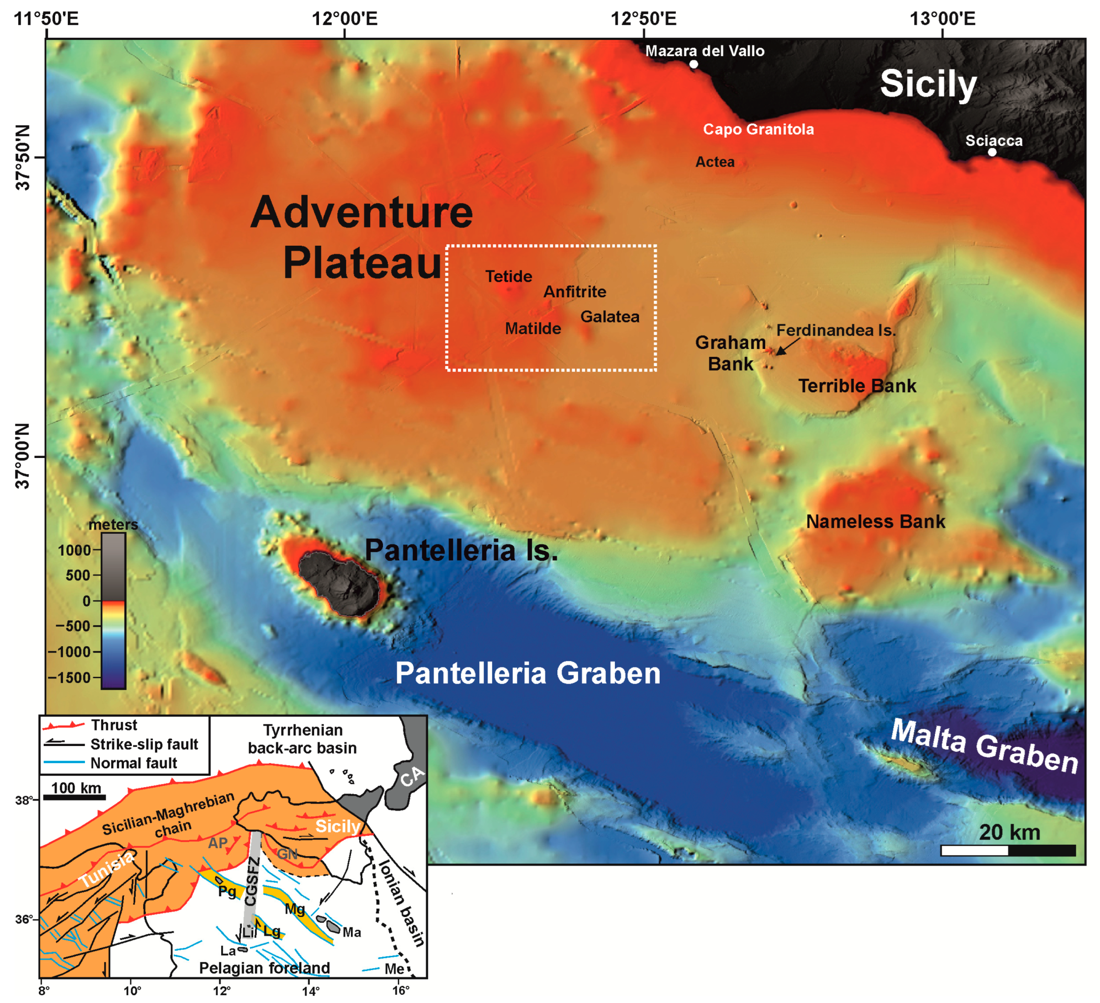
The Sicilian Channel (Figure 1) hosts a continental rift that combines most of these morphological and tectonic features. The rifting process that led to the formation of the NW-trending tectonic grabens of Pantelleria, Linosa and Malta since the early Pliocene is considered an example of rifting generated as a passive response to a regional stress field [4,5]. It is characterized by diffuse volcanism, which led to the formation of the volcanic islands of Pantelleria and Linosa and to several submarine volcanic manifestations. Other volcanoes are located along the NNE-trending Capo Granitola–Sciacca lithospheric fault zone that crosses the central part of the rift (see inset in Figure 1). The grabens exhibit the morphological and structural characteristics of mature rifting, even if they have not developed into a complete oceanic spreading center.

Figure 1.
General physiographic map of the Sicilian Channel (bathymetry data from the EMODNet Bathymetry Portal, http://emodnet-bathymetry.eu/, accessed on 15 May 2024). The white rectangular box indicates the “Tetide volcanic cluster”. In the lower-left corner, there is a tectonic sketch of the central Mediterranean Sea. AP = Adventure Plateau; CA = Calabrian Arc; CGSFZ = Capo Granitola–Sciacca Fault Zone; GN = Gela Nappe; Ma = Malta islands; Me = Malta escarpment; Pg = Pantelleria graben; Mg = Malta graben; Lg = Linosa graben; Li = Linosa Island; La = Lampedusa Island.
Here, we describe a group of small monogenic volcanoes (Tetide, Anfitrite, Matilde and Galatea) in the eastern sector of the Adventure Plateau [6] (Figure 1) that are aligned along the main direction of the rift grabens and whose origin is still unclear. This NNW–SSE-trending volcanic group, referred to in this work as the “Tetide volcanic cluster”, is analyzed using a series of vintage multichannel seismic reflection profiles and gravimetric data, as well as recently acquired high-resolution seismic reflection profiles. It is interpreted as the possible surface expression of a failed rift zone where extension was unable to generate a tectonic depression.
2. Materials and Methods
The high-resolution seismic sections presented in this paper are both CHIRP and Boomer data (Figure 2). The CHIRP profiles were acquired from the R/V OGS Explora in November 2013 using a hull-mounted Chirp II Sub-Bottom Profiler, while the Boomer data were acquired with an AAE301 plate in October 2022 from a boat on which the system was installed.
The sweep length of the CHIRP data was 10 ms at frequencies between 2 and 7 kHz. The ping rate was 2 pings per second, the sampling rate 0.05 ms and the acquisition window 300 ms. During data acquisition, the ship speed was 4.5 knots, so the average measurement interval was ∼1 m. The data were acquired in envelope mode and subsequently processed as follows: (1) derivative method to obtain analytical traces [7]; (2) spherical divergence and absorption compensation; (3) trace editing and de-spiking; (4) automatic gain control to homogenize the traces; and (5) Stolt time migration.
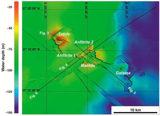
Figure 2.
Bathymetric map of the area around the “Tetide volcanic cluster”. Background data taken from the EMODNet Bathymetry Portal, http://emodnet-bathymetry.eu/ (accessed on 15 May 2024), integrated with multibeam high-resolution data from OGS [8] and multibeam high-resolution data acquired by the German vessel R/V Meteor [9].

The Boomer source consists of an electrodynamic transducer mounted on a catamaran frame and a pre-amplified fixed streamer equipped with 10 hydrophones connected in series. Each hydrophone can be switched on and off, extending the active range from 1 to 10 m. The distance between the source and the streamer (offset) was 20 m. The firing rate of the plate (the delivered energy unit is 300 J/pulse) was 2 shots per second, and the reflected signal was sampled at 0.05 ms with a time window of 400 ms. The seismic data were tracked using a navigation device connected to a differential GPS for accurate positioning. The data processing included the following: (1) DC (direct current) offset removal; (2) spherical divergence recovering and amplification; (3) time-varying bandpass filter; (4) predictive deconvolution to remove reverberation and increase the vertical resolution; and (5) Stolt time migration.
A network of 2D multichannel seismic reflection profiles, provided by the Italian Ministry of Economic Development in the framework of the project “Visibility of Petroleum Exploration Data in Italy “ViDEPI” (http://www.videpi.com, accessed on 15 May 2024), was used to build the contour map of the Messinian unconformity expressed in TWT (two-way traveltime) beneath the seafloor. To better constrain the position of this unconformity, information in the literature and the two offshore exploration wells closest to the study area, Onda 1 and Orione Est of the ViDEPI Project, were used [5,10,11].
During a recent geophysical–geological survey conducted between 16 July and 5 August 2023 by the German vessel R/V Meteor (M191), a significant number of multibeam and high-resolution seismic sections were acquired at several locations in the Sicilian Channel [9], particularly in the eastern sector of the Adventure Plateau (Tetide volcanic area), where a new small volcanic center (named Matilde) was discovered. The multibeam coverage realized during this cruise has complemented the map already produced in this area [8].
A complete map of the Bouguer gravity anomalies in the vicinity of the “Tetide volcanic cluster” was constructed from ship-borne gravity measurements made by the former Osservatorio Geofisico Sperimentale (OGS) during several pioneering surveys (from 1965 to 1972) in the Mediterranean Sea [12]. Details of the acquisition system can be found in Makris et al. [13], and the processing steps used to create the Bouguer anomaly map were described in detail in Lodolo et al. [14].
3. Geological Background of the Sicilian Channel and the Rift Zone
The Sicilian Channel is a broad shallow-water platform in the central Mediterranean between Sicily and Tunisia (see Figure 1). It hosts a foreland–foredeep chain system consisting of the Pelagian foreland, the Gela foredeep and the offshore part of the Neogene-Quaternary Maghrebian chain, e.g., [15,16], which was formed during the NNW–SSE-trending Neogene convergence between the African and European plates [17,18]. The central sector of the Pelagian foreland, part of the northern continental margin of the African plate, is characterized by the presence of three deep, NW–SE-trending tectonic grabens (Pantelleria, Malta and Linosa) that form the Sicilian Channel rift zone [4,19,20,21,22,23,24,25]. These grabens are bounded by kilometer-long NW–SE trending normal faults, which also affect the central-southern part of the Adventure Plateau [4,5,10].
The rift zone has developed since the early Pliocene and is divided into two independent sectors separated by the Capo Granitola–Sciacca Fault Zone [26], a NNE–SSW-trending lithospheric shear zone. The western sector comprises the Pantelleria graben, while the eastern one includes the Malta and Linosa grabens. The Capo Granitola–Sciacca Fault Zone extends for at least 200 km from the island of Linosa to the southern coast of Sicily, and is overall dominated by a transpressive tectonic regime [5,23,26,27,28,29,30].
The ~8000 km2 Adventure Plateau is located along the north-western sector of the Sicilian Channel (Figure 1) and represents the shallowest part of the area, with depths ranging from 50 to 150 m [31]. It is characterized by an almost flat morphology that turns into a gentle slope towards the Pantelleria graben. The 6–7 km thick stratigraphic sequence of the Adventure Plateau consists of Triassic–Eocene, predominantly carbonate sequences and siliciclastic Oligocene–Quaternary sequences [10,11]. In particular, the Plio-Quaternary sequence consists of calcarenites and organogenic sands [6,31], which overlie an extensive erosional surface, the well-known Messinian unconformity [10,11]. The complex structural setting of the Adventure Plateau is the result of compressional tectonics associated with the following: (i) the late Miocene activity of ESE–WNW-trending thrusts and back-thrusts that form the outer sector of the Sicilian–Maghrebian chain, and (ii) the Pliocene to Quaternary evolution of the NW–SE-trending normal faults associated with the formation of the Pantelleria graben [4,10,27,28,32,33,34,35].
The Sicilian Channel is characterized by diffuse anorogenic volcanism that occurred mainly in the Plio-Pleistocene [6,36], although some eruptive events have been documented in historical times, such as the submarine eruption of Ferdinandea Island on Graham Bank (Figure 1) in 1831 [37,38] and the eruption ~5 km NW of Pantelleria Island in 1891 [39,40]. Holocene volcanic lavas have also been sampled at Actea Volcano (Figure 1) near the Sicilian coast of Capo Granitola [41,42]. The most voluminous volcanic edifices are found on the islands of Pantelleria and Linosa, most of which are below sea level [5,43,44,45,46]. Submarine volcanic centers have been recognized based on a combination of geophysical observations, direct sampling and interpretations of seafloor landforms in the Terrible, Nameless and Graham banks, off the coast of Capo Granitola–Sciacca, in the eastern sector of the Adventure Plateau and near the Pantelleria and Linosa grabens [5,6,36,37,38,41,47,48,49]. Most of the volcanism is probably related to the rifting processes in the central part of the Sicilian Channel and the magma upwelling along the Capo Granitola–Sciacca Fault Zone [5,26,41,48].
4. Tetide Volcanic Cluster
In this paragraph, the “Tetide volcanic cluster” is described based on information in the literature and new geophysical data. It consists of four submarine volcanoes (Tetide, Galtea, Matilde and Anfitrite, see Figure 1), which are quite close to each other and form a 16 km long NW–SE trending alignment roughly parallel to the axis of the Pantelleria graben.
Anfitrite is the only volcanic feature of the Tetide cluster that was mapped in detail [8,11] before the Meteor cruise (M191) that mapped Tetide, Galatea, and a newly discovered submarine feature named Matilde [9].
Tetide is the largest and northernmost volcano in the eastern part of the Adventure Plateau (Figure 3). It is ~9 km2 in size and ~40 m high, and its summit is ~18 m below sea level [6]. Its morphology resembles a quasi-circular dome characterized by a flat top [6,11]. Sparker and Boomer profiles crossing the Tetide Volcano are reported in Calanchi et al. [6] and Civile et al. [11].
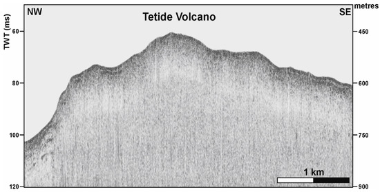
Figure 3.
Reprocessed Boomer profile crossing the Tetide Volcano (modified from Civile et al. [11]). See location in Figure 2.
Figure 3.
Reprocessed Boomer profile crossing the Tetide Volcano (modified from Civile et al. [11]). See location in Figure 2.
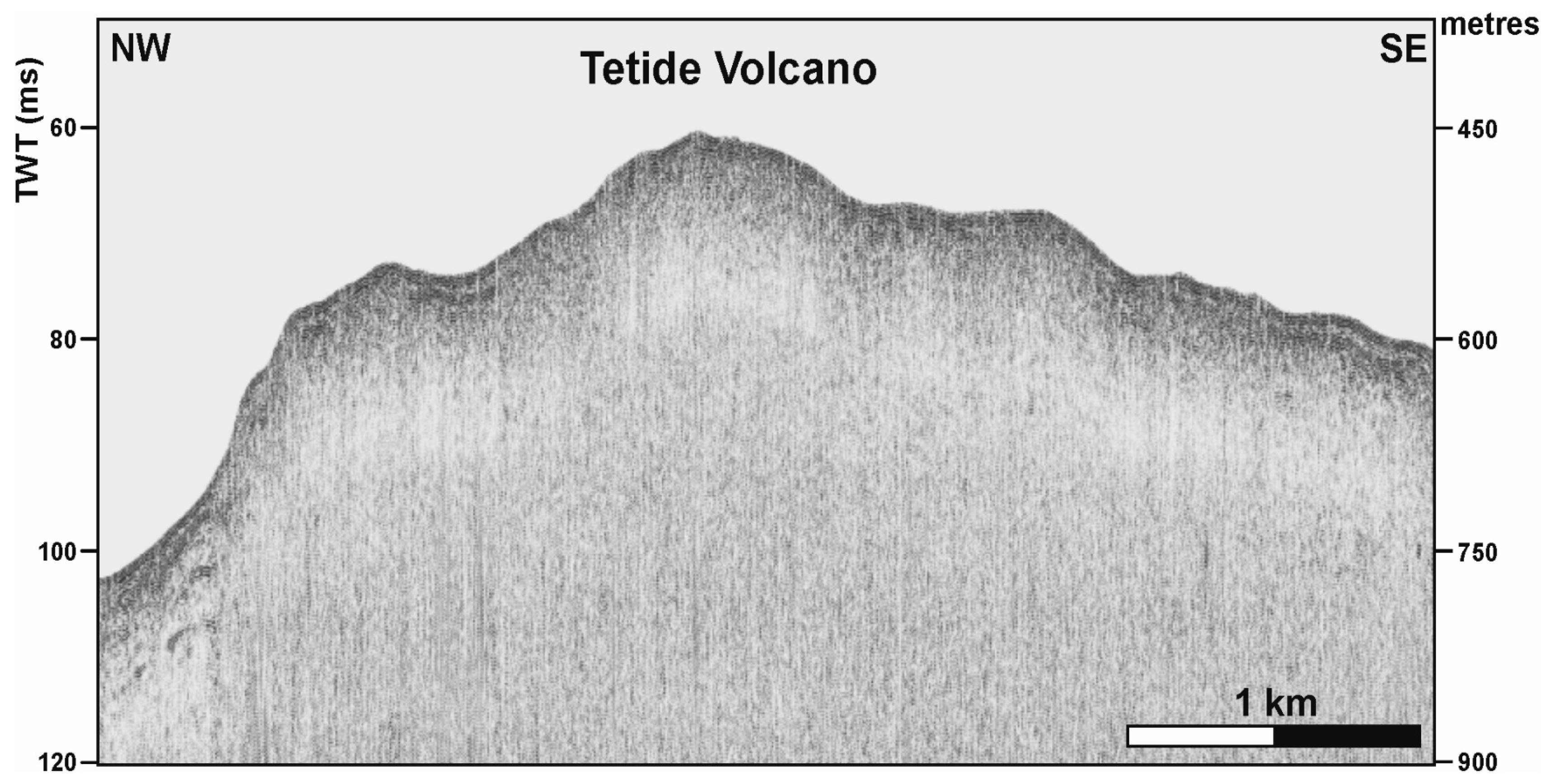
Anfitrite [32] consists of two different volcanic bodies, namely Anfitrite 1 and Anfitrite 2 [8] (Figure 4). Anfitrite 1 covers an area of ~1.8 km2 and has a semicircular shape with a diameter of ~1.5 km. In its southern part, the volcanic edifice consists of a crater with a diameter of 500 m and a shallow north-eastern rim that lies 35 m below sea level. A semi-circular ridge, which could be a remnant of a larger dismantled volcanic edifice, occupies the north-western part of Anfitrite 1. A recent volcanic neck has been identified along Anfitrite 1 [8]. Anfitrite 2 consists of a 1.5 km long and 1 km wide NNE–SSW trending ridge whose shallowest peak reaches a water depth of ~37 m. The deep structure of the Anfitrite volcanic complex was analyzed by Civile et al. [11] through the interpretation of multichannel seismic sections. These authors identified two magmatic outcrops generating Anfitrite 1 and 2, which are likely related to the presence of a large magmatic intrusion that fractures and deforms the sedimentary sequence into a dome-like geometry on a shallow crustal level.

Figure 4.
CHIRP profile crossing the two Anfitrite volcanoes. See location in Figure 2.
Figure 4.
CHIRP profile crossing the two Anfitrite volcanoes. See location in Figure 2.
Between Anfitrite and Galatea is the newly documented Matilde volcanic edifice (Figure 5). It is 1.7 km wide and has a semicircular plan shape with an arcuate scar in its north-eastern sector (see the detailed description of this volcano in [9]). Galatea consists of an ellipsoidal, 3 km wide structure with margins at a water depth of 120 m. At the center of this structure is a 600 m long and 20 m high SW–NE-trending ridge, culminating in a well-preserved cone shape whose summit crater lies at a water depth of 74 m [6]. Sparker and sub-bottom profiles crossing the Galatea Volcano are reported in Calanchi et al. [6] and Miccallef et al. [9].
All the volcanic structures described above show a morphology indicative of long-lasting exposure conditions related to the dramatic drop in sea level during the Messinian period and especially since the Last Glacial Maximum [50].
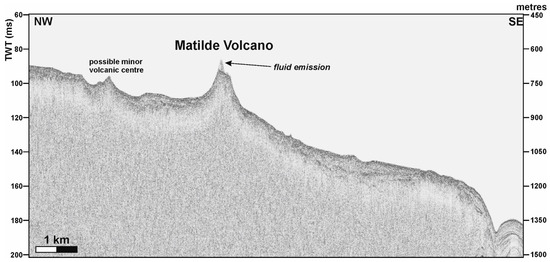
Figure 5.
Boomer profile crossing the Matilde Volcano and another possible small volcanic center. A fluid emission escapes from the crater of the volcano. See location in Figure 2.
Figure 5.
Boomer profile crossing the Matilde Volcano and another possible small volcanic center. A fluid emission escapes from the crater of the volcano. See location in Figure 2.

The only two volcanoes in the cluster that have been sampled to date are Tetide and Anfitrite. The magma types of these volcanic edifices include tholeiites (Tetide) and alkali basalts (Anfitrite) [6]. According to Calanchi et al. [6], these volcanoes were formed by the emplacement of mantle-derived magmas in a stress regime with an extension perpendicular to the orientation of the Pantelleria graben. Furthermore, the interpretation of the petrogenetic significance of the mineral chemistry and petrography of the volcanic rocks of the Tetide and Anfitrite volcanoes indicates the rapid ascent of the magmas from a medium-pressure reservoir [6].
5. Results and Discussion
The interpretation of nine multichannel seismic lines documents the gentle dome-like shape of the Messinian unconformity, which in turn is covered by sub-horizontal Plio-Pleistocene reflectors showing onlap terminations against the unconformity itself (Figure 6). This erosional surface is seismically expressed by an undulated, high-amplitude and continuous reflector that is generally well recognized on all seismic sections (e.g., Figure 6).
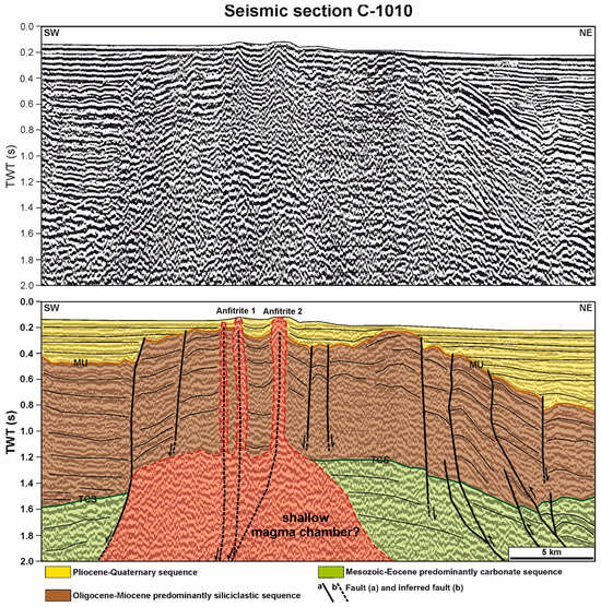
Figure 6.
Multichannel seismic section C-1010 (available from the ViDEPI Portal, www.videpi.com, accessed on 15 May 2024) crossing Anfitrite 1 and 2 volcanic edifices and the corresponding line drawing (modified from Civile et al. [11]). MU = Messinian unconformity; TCS = Top of the predominantly carbonate sequence. See location in Figure 2.
We have chosen to show only seismic section C-1010 because it is the only one that crosses orthogonally the “Tetide volcanic cluster” and is of acceptable quality. It is therefore undoubtedly the most representative line for the objective of the work and has been shown both with and without interpretation.
The interpretation of the seismic section C-1010 (Figure 6) shows the presence of a doming structure interpreted as the result of a magma ascent along a NW–SE-trending normal fault characterized by some minor branches in the upper part and along which the “Tetide volcanic cluster” developed. The presence of a major normal fault with minor branches in the upper part, which represented a preferential path for the upward migration of magma, is not clearly recognizable from the seismic data.
Several normal faults with a NW–SE-trending parallel to the axis of the Pantelleria graben axis have been shown to affect part of the Adventure Plateau and are associated with the opening of this tectonic depression.
The Plio-Pleistocene sequence appears to be almost undeformed in the seismic section, indicating a period of probable tectonic inactivity during its deposition, with the exception of the area near the magma ascents where the reflectors are folded (Figure 6). The magma ascents seem to be very recent and may be associated with a reactivation of the upward propagation of the branches of the main NW–SE normal fault. The magma ascents forming the volcanic edifices of Anfitrite 1 and 2 are characterized by the pull-up effect of the reflectors, which makes it possible to identify the magmatic conduits that reach the seafloor.
The interpretation of seismic line C-1010 and in general the interpretation of seismic lines in this sector of the Sicilian Channel is based on the many years of experience gained by analyzing a large number of multichannel seismic reflection profiles acquired both by OGS and those available within the ViDEPI Project, as well as by studying the well data that allowed us to calibrate the seismic interpretation. This generally allowed us to identify two main marker horizons, the Messinian unconformity and the top of the Mesozoic-Cenozoic carbonate sequence. The Messinian unconformity is generally clearly recognizable in all seismic lines as a high-amplitude, undulating and continuous reflector. Instead, the top of the carbonate sequence is not always clearly recognizable due to the presence of highly tectonized zones.
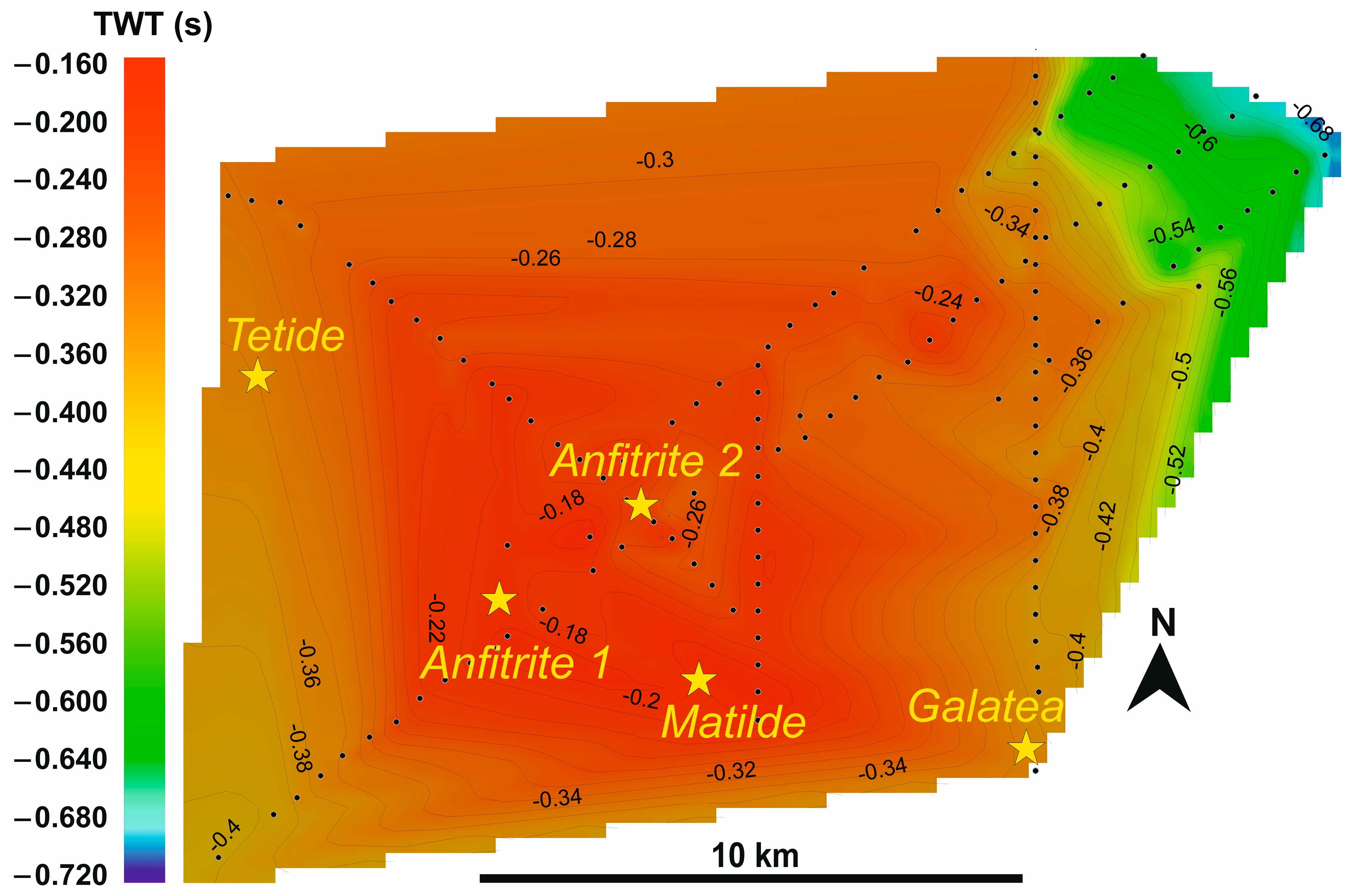
The contour map of the Messinian unconformity (Figure 7) shows that this surface reaches values of about 0.2 s TWT (value in time from the sea floor to the top of the Messinian horizon) along the alignment of the volcanoes and then changes to values of about 0.34 s TWT to the NE and SW. The same occurs to the north and south of the volcanoes in a more pronounced form, indicating that the doming effect was caused by the magma ascent. Variations in the thickness of the Plio-Quaternary sequence from 220 m at the top of the doming structure to about 370 m at its edge can be hence observed (these values for thickness have been derived by applying an interval acoustic velocity of 2200 m/s for the whole sequence).

Figure 7.
Contour map of the top of the Messinian unconformity derived from the seismic data interpretation. Interpreted points indicated by the black small circles. Values in TWT (two-way travel time) below the seafloor. Yellow stars indicate the positions of the individual volcanoes.
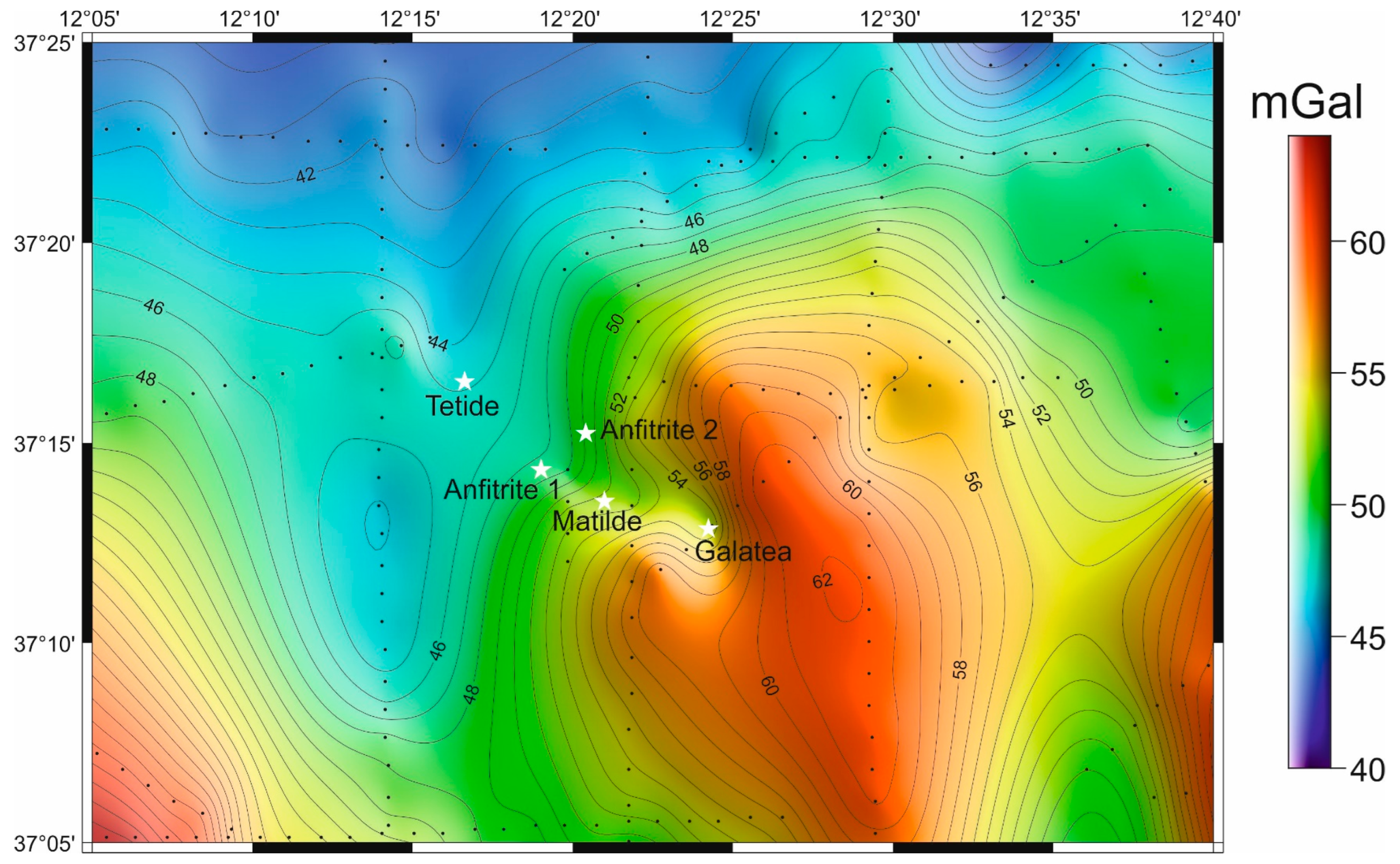
The Bouguer anomaly map (Figure 8) shows the presence of a WNW–ESE-trending positive anomaly (+62 mGals) located a few kilometers east of the “Tetide volcanic cluster”. This is the most significant anomaly in the vicinity of the volcanic area. The maximum value of this anomaly is found in the south-eastern sector of the volcanic group, in a rather decentralized position with respect to its center. This could indicate that the magma chamber that feeds the volcanic group is limited and restricted by the tectonic structures in this sector of the edge of the Adventure Plateau. A few kilometers to the east, in the western part of the Terrible Bank, there is another positive anomaly known to host several volcanic features [48].
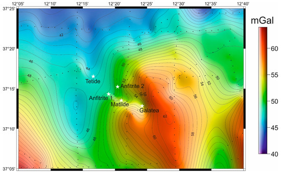
Figure 8.
Complete Bouguer anomaly map of the area surrounding the “Tetide volcanic cluster”. White stars indicate the positions of the individual volcanoes.
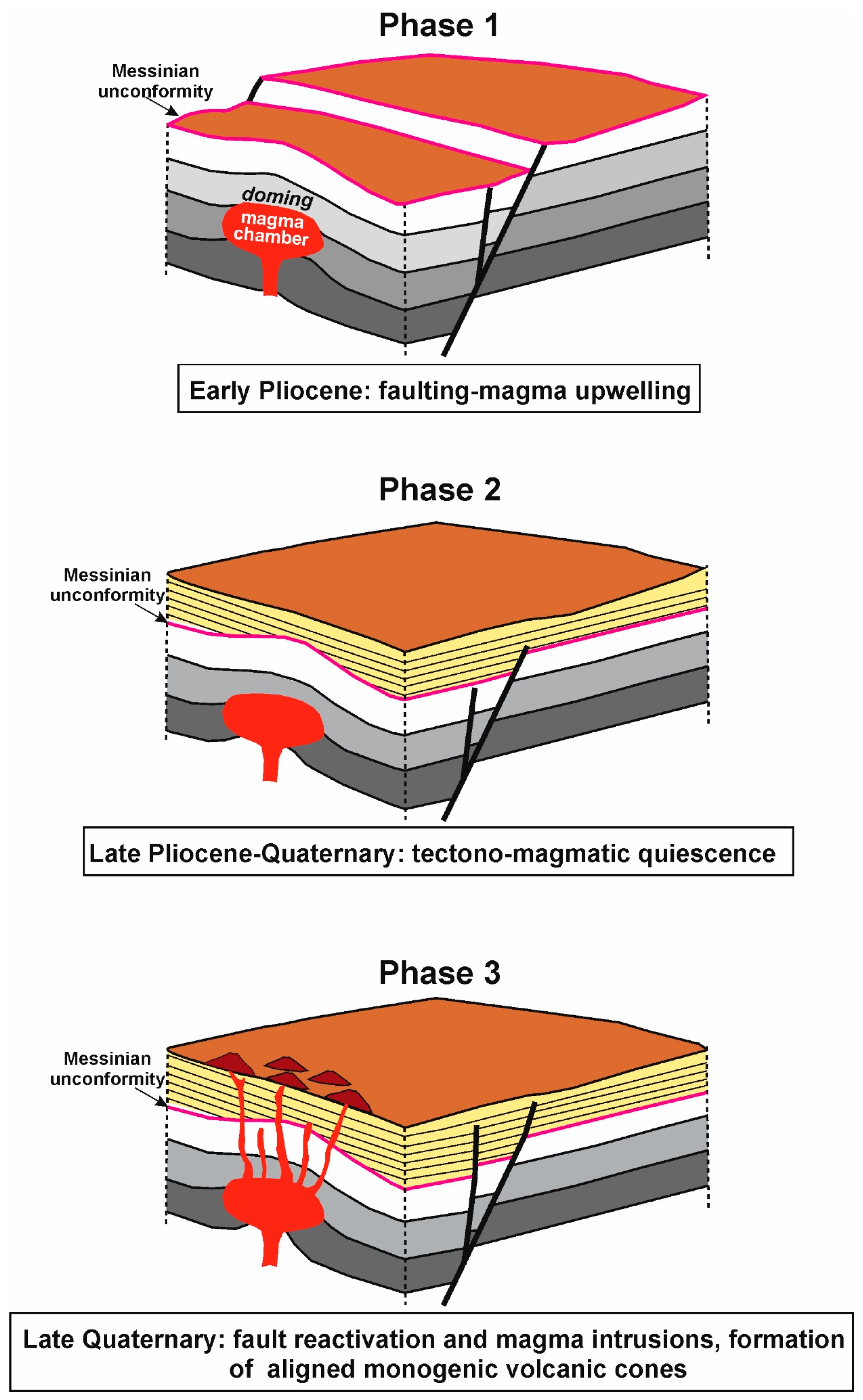
Based on the above results, a possible evolution of the “Tetide volcanic cluster” is proposed (Figure 9):
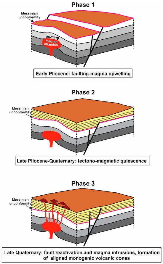
Figure 9.
Simplified sketch of the evolution of the “Tetide volcanic cluster” drawn according to the data presented in this work.
- Phase 1: Swelling in the early Pliocene associated with a magma ascent that probably occurred along a presumed NW–SE-trending normal fault.
- Phase 2: A phase of volcanic and tectonic stasis during which the Plio-Pleistocene sequence was deposited.
- Phase 3: A late Quaternary new upward migration of magma along zones of weakness developed almost up to the surface above the doming zone as the result of a possible reactivation of the main normal fault. This made possible the formation of monogenic volcanic edifices on the seafloor.
On the basis of the presented data, the following basic aspects can be highlighted: (1) the alignment of the volcanic edifices of the “Tetide volcanic cluster” along a NW–SE trend similar to that of the Pantelleria graben; (2) the presence of a gravimetric anomaly, albeit weak, together with the documented dome-like shape of the Messinian unconformity and the doming structure visible in the seismic lines C-1010 allowed us to infer the possible presence of a shallow magma chamber beneath the “Tetide volcanic cluster”, which is tentatively associated with the presence of a major NW–SE normal fault. These faults have been documented in this sector of the Adventure Plateau; (3) the formation of the volcanic bodies on the seafloor during the late Quaternary by the ascent of magma possibly driven by the reactivation of the NW–SE-trending normal fault. Although the data presented in this work do not allow a definitive conclusion, we have hypothesized that the “Tetide volcanic cluster” could be the product of a failed rift process. It was not able to cause significant extension in this area along with the formation of a deep trough, and only produced limited volcanism. The causes for the premature abandonment of this structure are not known from a tectonic perspective and may need to be sought in the broader context of the region’s deformation style, which instead led to the development of a well-defined tectonic depression to the south (i.e., the Pantelleria graben), but which never reached the final stage of spreading with the formation of oceanic crust. For the hypothesis that the “Tetide volcanic cluster” could be considered a failed rift, we have no evidence regarding why it did not develop like the other deep tectonic depressions of the Sicilian Channel, but a hypothesis can be put forward. The eastern part of the Sicilian Channel rift zone hosts two sites of crustal extension, the Linosa and Malta grabens, while in the western part, there is only the Pantelleria graben, which is the largest tectonic depression of the rift zone. The extension was probably concentrated in this site, while elsewhere, as in the case of the “Tetide volcanic cluster”, it was not sufficient to generate a trough.
An example of an incipient and prematurely abandoned rift that bears remarkable morphological and structural similarities to the “Tetide volcanic cluster” is illustrated by a linear chain of submarine volcanic edifices that parallels the present-day western sector of the Scotia–Antarctic plate boundary. They were deposited in a rift-like environment related to the activity of the former western segment of the Scotia–Antarctica plate boundary [51]. The former segment was abandoned when the Phoenix–Antarctic ridge segments NW of the South Shetland Islands ceased spreading by about 3.3 Ma, and it jumped to the present-day location of the Bransfield Strait, an actively expanding marginal basin at the transition from mature rifting to incipient, punctuated spreading.
6. Conclusions
The presence of a series of volcanic edifices in the eastern sector of the Adventure Plateau, aligned parallel with the trend of the Pantelleria graben, suggests that they may represent the morphological expression of a failed rift, which was therefore unable to generate significant extension as well as a well-developed tectonic depression. The analysis of a series of multichannel seismic sections has shown a significant bulging of the Messinian unconformity and the underlying sequences, related to the formation of a shallow magma chamber, and then a series of magmatic intrusions that reached the seafloor forming the present-day volcanoes. The presence of a shallow magma chamber can also be inferred from a significant positive gravimetric anomaly in the complete Bouguer map. The data allowed us to reconstruct the evolutionary processes of this group of volcanoes, here referred to as the “Tetide volcanic cluster” (including Tetide, Anfitrite 1 and 2, Galatea and the recently discovered Matilde Volcano). The phase of inflation, which occurred in the early Pliocene, was probably associated with the presence of a main NW–SE-trending normal fault developed during the opening of the Pantelleria graben. This was followed by a quiescent phase during which the Plio-Quaternary sedimentary sequence was deposited. Then, following a new magmatic input, the lavas pushed upward through sub-vertical structural discontinuities related to a possible reactivation of the main NW–SE normal fault, generating the volcanic edifices of the cluster on the seafloor.
There is no evidence as to why this sector did not develop like the other tectonic depressions of the Sicilian Channel. One possible hypothesis is that the extension in the western part of the Sicilian Channel was concentrated on the largest tectonic depression of the rift zone, the Pantelleria graben, while elsewhere, as in the case of the “Tetide volcanic cluster”, it was not sufficient to generate a trough, and only generated localized volcanism. Instead, two sites of crustal extension, the Linosa and Malta grabens, developed in the eastern part of the Sicilian Channel rift zone.
A quite similar example of an early-stage failed rift is the western sector of the Scotia–Antarctica plate boundary, where a series of submarine volcanic edifices that are consistent with the trend of the Bransfield Basin further north, where rifting has evolved into a punctiform spreading, have been identified.
Author Contributions
Conceptualization, D.C. and E.L.; Methodology, E.L., D.C. and G.M.; Software, L.B. and G.M.; Validation, E.L., D.C. and A.M.; Formal analysis, D.C, G.M. and A.M.; Investigation, E.L., A.M. and L.B.; Writing—original draft preparation, D.C. and E.L.; Writing—review and editing, D.C., E.L., G.M., A.M. and L.B.; Visualization, D.C, G.M. and L.B.; Data curation, D.C., E.L. and L.B. All authors have read and agreed to the published version of the manuscript.
Funding
This research received no external funding.
Institutional Review Board Statement
Not applicable.
Informed Consent Statement
Not applicable.
Data Availability Statement
The multichannel seismic sections used in this study are available from the portal http://www.videpi.com (accessed on 15 May 2024). The H-R seismic sections presented here are available from the first author. Bathymetric data may be downloaded from the portal https://emodnet.ec.europa.eu/en/bathymetry.
Conflicts of Interest
The authors declare no conflicts of interest.
References
- Burke, K. Intracontinental rifts and aulacogens. In Continental Tectonics; National Academy of Sciences: Washington, DC, USA, 1980; pp. 42–49. [Google Scholar]
- Elling, R.; Stein, S.; Stein, C.A.; Gefeke, K. Three major failed rifts in Central North America: Similarities and differences. GSA Today 2022, 32, 4–11. [Google Scholar] [CrossRef]
- Stein, S.; Stein, C.A.; Elling, R.; Kley, J.; Keller, G.R.; Wysession, M.; Moucha, R. Insights from North America’s failed Midcontinent Rift into the evolution of continental rifts and passive continental margins. Tectonophysics 2018, 744, 403–421. [Google Scholar] [CrossRef]
- Civile, D.; Lodolo, E.; Accettella, D.; Geletti, R.; Ben-Avraham, Z.; Deponte, M.; Facchin, L.; Ramella, R.; Romeo, R. The Pantelleria graben (Sicily Channel, Central Mediterranean): An example of intraplate ‘passive’ rift. Tectonophysics 2010, 490, 173–183. [Google Scholar] [CrossRef]
- Civile, D.; Brancolini, G.; Lodolo, E.; Forlin, E.; Accaino, F.; Zecchin, M.; Brancatelli, G. Morphostructural setting and tectonic evolution of the central part of the Sicilian Channel (central Mediterranean). Lithosphere 2021, 2021, 7866771. [Google Scholar] [CrossRef]
- Calanchi, N.; Colantoni, P.; Rossi, P.L.; Saitta, M.; Serri, G. The Strait of Sicily continental rift systems: Physiography and petrochemistry of the submarine volcanic centres. Mar. Geol. 1989, 87, 55–83. [Google Scholar] [CrossRef]
- Baradello, L.; Battaglia, F.; Vesnaver, A. Fast method to transform chirp envelope data into pseudo-seismic data. Mar. Geophys. Res. 2021, 42, 14. [Google Scholar] [CrossRef]
- Civile, D.; Lodolo, E.; Zecchin, M.; Ben-Avraham, Z.; Baradello, L.; Accettella, D.; Cova, A.; Caffau, M. The lost Adventure Archipelago (Sicilian Channel, Mediterranean Sea): Morpho-bathymetry and Late Quaternary palaeogeographic evolution. Glob. Planet. Chang. 2015, 125, 36–47. [Google Scholar] [CrossRef]
- Micallef, A.; Geldmacher, J.; Watt, S.F.L.; Ferrante, G.M.; Ford, J.; Lodolo, E.; Civile, D.; Hodgetts, A.G.E.; Felgendreher, M.; Licari, J.G.; et al. Submarine volcanism in the Sicilian Channel revisited. Mar. Geol. 2024, 474, 107342. [Google Scholar] [CrossRef]
- Civile, D.; Lodolo, E.; Alp, H.; Ben-Avraham, Z.; Cova, A.; Baradello, L.; Accettella, D.; Burca, M.; Centonze, J. Seismic stratigraphy and structural setting of the Adventure Plateau (Sicily Channel). Mar. Geophys. Res. 2014, 35, 37–53. [Google Scholar] [CrossRef]
- Civile, D.; Lodolo, E.; Caffau, M.; Baradello, L.; Ben-Avraham, Z. Anatomy of a submerged archipelago in the Sicilian Channel (central Mediterranean Sea). Geol. Mag. 2016, 153, 160–178. [Google Scholar] [CrossRef]
- Morelli, C.; Gantar, C.; Pisani, M. Bathymetry, gravity and magnetism in the Strait of Sicily and in the Ionian Sea. Boll. Geofis. Teor. Appl. 1975, 17, 39–58. [Google Scholar]
- Makris, J.; Morelli, C.; Zanolla, C. The Bouguer gravity map of the Mediterranean Sea (IGCM-G). Boll. Geofis. Teor. Appl. 1998, 39, 79–98. [Google Scholar]
- Lodolo, E.; Zampa, L.; Civile, D. The Graham and Terrible volcanic province (NW Sicilian Channel): Gravimetric constraints for the magmatic manifestations. Bull. Volcanol. 2019, 81, 17. [Google Scholar] [CrossRef]
- Catalano, R.; Di Stefano, P.; Sulli, A.; Vitale, F.P. Paleogeography and structure of the central Mediterranean: Sicily and its offshore area. Tectonophysics 1996, 260, 291–323. [Google Scholar] [CrossRef]
- Catalano, R.; Merlini, S.; Sulli, A. The structure of western Sicily, Central Mediterranean. Pet. Geosci. 2002, 8, 7–18. [Google Scholar] [CrossRef]
- Gueguen, E.; Doglioni, C.; Fernandez, M. On the post-25 Ma geodynamic evolution of the western Mediterranean. Tectonophysics 1998, 298, 259–269. [Google Scholar] [CrossRef]
- Carminati, E.; Lustrino, M.; Doglioni, C. Geodynamic evolution of the central and western Mediterranean: Tectonics vs. igneous petrology constraints. Tectonophysics 2012, 579, 173–192. [Google Scholar] [CrossRef]
- Finetti, I.R. Geophysical study of the Sicily Channel Rift Zone. Boll. Geof. Teor. Appl. 1984, 26, 3–28. [Google Scholar]
- Reuther, C.D.; Eisbacher, G.H. Pantelleria rift-crustal extension in a convergent intraplate setting. Geol. Rundsch. 1985, 74, 585–597. [Google Scholar] [CrossRef]
- Boccaletti, M.; Cello, G.; Tortorici, L. Transtensional tectonics in the Sicily Channel. J. Struct. Geol. 1987, 9, 869–876. [Google Scholar] [CrossRef]
- Cello, G. Structure and deformation processes in the Strait of Sicily “rift zone”. Tectonophysics 1987, 141, 237–247. [Google Scholar] [CrossRef]
- Argnani, A. The Strait of Sicily rift zone: Foreland deformation related to the evolution of a back-arc basin. J. Geodyn. 1990, 12, 311–331. [Google Scholar] [CrossRef]
- Dart, C.J.; Bosence, W.J.; McClay, K.R. Stratigraphy and structure of the Maltese graben system. J. Geol. Soc. 1993, 150, 1153–1166. [Google Scholar] [CrossRef]
- Maiorana, M.; Artoni, A.; Le Breton, E.; Sulli, A.; Chizzini, N.; Torelli, L. Is the Sicily Channel a simple rifting zone? New evidence from seismic analysis with geodynamic implications. Tectonophysics 2023, 864, 230019. [Google Scholar] [CrossRef]
- Civile, D.; Lodolo, E.; Accaino, F.; Geletti, R.; Schiattarella, M.; Giustiniani, M.; Fedorik, J.; Zecchin, M.; Zampa, L. Capo Granitola-Sciacca Fault Zone (Sicilian Channel, Central Mediterranean): Structure vs magmatism. Mar. Pet. Geol. 2018, 96, 627–644. [Google Scholar] [CrossRef]
- Argnani, A.; Cornini, S.; Torelli, L.; Zitellini, N. Neogene-Quaternary foredeep system in the Strait of Sicily. Mem. Soc. Geol. Ital. 1986, 36, 123–130. [Google Scholar]
- Antonelli, M.; Franciosi, R.; Pezzi, G.; Querci, A.; Ronco, G.P.; Vezzani, F. Paleogeographic evolution and structural setting of the northern side of the Sicily Channel. Mem. Soc. Geol. Ital. 1988, 41, 141–157. [Google Scholar]
- Calò, M.; Parisi, L. Evidences of a lithospheric fault zone in the Sicily Channel continental rift (southern Italy) from instrumental seismicity data. Geophys. J. Int. 2014, 199, 219–225. [Google Scholar] [CrossRef]
- Ferranti, L.; Pepe, F.; Barreca, G.; Meccariello, M.; Monaco, C. Multi-temporal tectonic evolution of Capo Granitola and Sciacca foreland transcurrent faults (Sicily Channel). Tectonophysics 2019, 765, 187–204. [Google Scholar] [CrossRef]
- Colantoni, P.; Cremona, G.; Ligi, M.; Borsetti, A.M.; Cati, F. The Adventure Bank (off south-western Sicily): A present-day example of carbonate shelf sedimentation. Giorn. Geol. 1985, 47, 165–180. [Google Scholar]
- Argnani, A. Neogene tectonics of the Strait of Sicily. In Geological Development of the Sicilian-Tunisian Platform, Proceedings of International Scientific Meeting; Unesco Report in Marine Science; Max, M.D., Colantoni, P., Eds.; University of Urbino: Urbino, Italy, 1993; Volume 58, pp. 55–60. [Google Scholar]
- Argnani, A. Neogene basins in the Strait of Sicily (Central Mediterranean): Tectonic settings and geodynamic implications. In Recent Evolution and Seismicity of the Mediterranean Region; Boschi, E., Mantovani, E., Morelli, A., Eds.; Kluwer Academic Publication: Dordrecht, The Netherlands, 1993; pp. 173–187. [Google Scholar]
- Lentini, F.; Carbone, S.; Catalano, S. Main structural domains of the central Mediterranean region and their tectonic evolution. Boll. Geofis. Teor. Appl. 1994, 36, 103–125. [Google Scholar]
- Grasso, M. The Apenninic-Maghrebian orogen in southern Italy, Sicily and adjacent areas. In Anatomy of an Orogen: The Apennines and Adjacent Mediterranean Basins; Vai, G.B., Martini, I.P., Eds.; Kluwer Academic Publishers: Norwell, MA, USA, 2001; pp. 255–286. [Google Scholar]
- Rotolo, S.G.; Castorina, F.; Cellula, D.; Pompilio, M. Petrology and geochemistry of submarine volcanism in the Sicily Channel. J. Geol. 2006, 114, 355–365. [Google Scholar] [CrossRef]
- Colantoni, P.; Del Monte, M.; Gallignani, P.; Zarudzky, E.F.K. Il Banco Graham: Un vulcano recente nel Canale di Sicilia. Giorn. Geol. 1975, 40, 141–162. [Google Scholar]
- Carapezza, M.; Ferla, P.; Nuccio, P.M.; Valenza, M. Caratteri metrologici e geochimica delle vulcaniti dell’Isola Ferdinandea. Rend. Ital. Soc. Mineral. Pet. 1979, 35, 377–388. [Google Scholar]
- Washington, H.S. The submarine eruption of 1831 and 1891 near Pantelleria. Am. J. Sci. 1909, 27, 131–150. [Google Scholar] [CrossRef]
- Conte, A.M.; Martorelli, E.; Calarco, M.; Sposato, A.; Perinelli, C.; Coltelli, M.; Chiocci, F.L. The 1891 submarine eruption offshore Pantelleria Island (Sicily Channel, Italy): Identification of the vent and characterization of products and eruptive style. Geochem. Geophys. Geosyst. 2014, 15, 2555–2574. [Google Scholar] [CrossRef]
- Lodolo, E.; Civile, D.; Zecchin, M.; Zampa, L.S.; Accaino, F. A series of volcanic edifices discovered a few kilometers off the coast of SW Sicily. Mar. Geol. 2019, 416, 105999. [Google Scholar] [CrossRef]
- Lodolo, E.; Renzulli, A.; Cerrano, C.; Calcinai, B.; Civile, D.; Quarta, G.; Calcagnile, L. Unraveling past submarine eruptions by dating lapilli tuff-encrusting coralligenous (Actea Volcano, NW Sicilian Channel). Front. Earth Sci. 2021, 9, 664591. [Google Scholar] [CrossRef]
- Rossi, P.I.; Tranne, C.A.; Calanchi, N.; Lanti, E. Geology, stratigraphy and vulcanological evolution of the island of Linosa (Sicily Channel). Acta Vulcan. 1996, 8, 73–90. [Google Scholar]
- Civetta, L.; D’Antonio, M.; Orsi, G.; Tilton, G.R. The Geochemistry of Volcanic Rocks from Pantelleria Island, Sicily Channel: Petrogenesis and Characteristics of the Mantle Source Region. J. Petrol. 1998, 39, 1453–1491. [Google Scholar] [CrossRef]
- Romagnoli, C.; Belvisi, V.; Innangi, S.; Di Martino, G.; Tonielli, R. New insights on the evolution of the Linosa Volcano (Sicily Channel) from the study of its submarine portions. Mar. Geol. 2020, 419, 106060. [Google Scholar] [CrossRef]
- White, J.C.; Neave, D.A.; Rotolo, S.G.; Parker, D.F. Geochemical constraints on basalt petrogenesis in the Strait of Sicily Rift Zone (Italy): Insights into the importance of short length scale mantle heterogeneity. Chem. Geol. 2020, 545, 119650. [Google Scholar] [CrossRef]
- Beccaluva, L.; Colantoni, P.; Di Girolamo, P.; Savelli, C. Upper-Miocene submarine volcanism in the Strait of Sicily (Banco senza Nome). Bull. Volcan. 1981, 44, 573–581. [Google Scholar] [CrossRef]
- Coltelli, M.; Cavallaro, D.; D’Anna, G.; D’Alessandro, A.; Grassa, F.; Mangano, G.; Patane, D.; Gresta, S. Exploring the submarine Graham Bank in the Sicily Channel. Ann. Geophys. 2016, 59, S0208. [Google Scholar] [CrossRef]
- Cavallaro, D.; Coltelli, M. The Graham volcanic field offshore southwestern Sicily (Italy) revealed by high-resolution seafloor mapping and ROV images. Front. Earth Sci. 2019, 7, 311. [Google Scholar] [CrossRef]
- Lodolo, E.; Loreto, M.F.; Melini, D.; Spada, G.; Civile, D. Palaeo-shoreline configuration of the Adventure Plateau (Sicilian Channel) at the Last Glacial Maximum. Geosciences 2022, 12, 125. [Google Scholar] [CrossRef]
- Lodolo, E.; Pérez, L.F. An abandoned rift in the southwestern part of the South Scotia Ridge (Antarctica): Implications for the genesis of the Bransfield Strait. Tectonics 2015, 34, 2451–2464. [Google Scholar] [CrossRef]
Disclaimer/Publisher’s Note: The statements, opinions and data contained in all publications are solely those of the individual author(s) and contributor(s) and not of MDPI and/or the editor(s). MDPI and/or the editor(s) disclaim responsibility for any injury to people or property resulting from any ideas, methods, instructions or products referred to in the content. |
© 2024 by the authors. Licensee MDPI, Basel, Switzerland. This article is an open access article distributed under the terms and conditions of the Creative Commons Attribution (CC BY) license (https://creativecommons.org/licenses/by/4.0/).