Review

Ship Emission Measurements Using Multirotor Unmanned Aerial Vehicles: Review

Waterborne Transport and Air Pollution Laboratory, Marine Research Institute, Klaipėda University, 92294 Klaipėda, Lithuania
*
Author to whom correspondence should be addressed.
J. Mar. Sci. Eng. 2024, 12(7), 1197; https://doi.org/10.3390/jmse12071197
Submission received: 6 June 2024 / Revised: 7 July 2024 / Accepted: 12 July 2024 / Published: 17 July 2024

Abstract

:
This review investigates the ship emission measurements using multirotor unmanned aerial vehicles (UAVs). The monitoring of emissions from shipping is a priority globally, because of the necessity to reduce air pollution and greenhouse gas emissions. Moreover, there is widespread global effort to extensively measure vessel fuel sulfur content (FSC). The majority of studies indicate that more commonly used methods for measuring ship emission with UAVs is the sniffing method. Most of the research is concerned with determining the fuel sulfur content. Fuel sulfur content can be determined by the ratio of CO2 and SO2 concentration in the exhaust gas plume. For CO2, the non-dispersive infrared (NDIR) method is used, the most common measuring range reaches 0–2000 ppm, the overall measuring range 0–10,000 ppm, and detection accuracy is ±5–300 ppm. For SO2, the electrochemical (EC) method is used, the measuring range reaches 0–100 ppm, and the detection accuracy is ±5 ppm. Common UAV characteristics, used in measurement with ships, involve the following: 8–10 m/s of wind resistance, 5–6 kg maximum payload, and a flight distance ranging from 5 to 10 km. This can change in the near future, since a variety of emission measuring devices that can be mounted on UAVs are available on the market. The range of available elements differs from device to device, but available ranges are allowed and the accuracy provides good possibilities for wider research into ship emissions.

1. Introduction

Global shipping consumes 200 to 400 million tons of fuel annually [1,2]. This significant fuel consumption contributes to air pollution and greenhouse gas emissions [3]. Efforts to reduce emissions from shipping have been ongoing: Annex VI of the 1997 MARPOL Protocol included Sulfur Emission Control Areas (SECAs), with the aim of reducing air pollution by sulfur oxides, and Nitrogen Emission Control Areas (NECAs) to reduce nitrogen oxide (NOx) emissions from ships constructed after 2016 [4,5]. Currently, the efforts and plans to decarbonize shipping have gained significant attention as the maritime industry seeks to reduce its environmental impact and contribute to global climate goals. Both the International Maritime Organization (IMO) and the EU have set ambitious targets to reduce carbon emissions from shipping. The EU’s strategic goal is to achieve climate neutrality across all economies by 2050, with an interim target set for 2030 to reduce greenhouse gas emissions by 55% compared to 1990 levels [6]. The strategic decarbonization objectives of the International Maritime Organization (IMO) were adopted on 13 April 2018, in resolution MEPC 304(72) with a goal of reducing the total annual greenhouse gas emissions by no less than 50% compared to 2008 levels and striving for neutrality in 2050 [7]. During the meeting of the Marine Environment Protection Committee (MEPC 80) held on 3–7 July 2023, the Member States of IMO adopted the 2023 IMO Strategy on Reduction of Greenhouse Gases (GHG) Emissions from Ships, with new targets to tackle emissions [8]. These targets and initiatives underscore the concerted efforts required to mitigate climate change impacts within the maritime sector, aligning with broader EU and international sustainability objectives [7,9]. Aligning with the IMO and EU decarbonization goals various studies have explored different strategies and technologies aimed at achieving decarbonization in the shipping sector [10,11,12,13,14].
The monitoring of emissions from shipping is a complicated task that needs to be addressed to effectively manage and reduce pollution levels. Ship exhaust gas plumes disperse based on wind conditions, leading to a varied distribution of pollutants over shipping lanes [2,15]. Ensuring effective air quality monitoring in ports involves capturing emissions from naval traffic and differentiating between emissions from various types of ships [3,16]. Additionally, the effective monitoring of shipping is essential to ensure compliance with the MARPOL fuel sulfur content (FSC) regulations [17,18,19]. While a standard procedure for determining FSC involves taking fuel samples and verifying vessel documentation [17], conducting such analyses can be slow and cumbersome, particularly in the areas with heavy ship traffic. Consequently, several remote measurement techniques have been developed, which rely on the SO2/CO2 concentration ratio [20,21,22]. Advanced technologies such as the automatic identification system (AIS) data can assist in evaluating ship emissions and their effects on air quality [23]; however, in many cases, the ship exhaust gas plume can be out of reach for shore-based stations. One of the ways to resolve this and improve ship emission measurement possibilities was the start of using multirotor UAVs. Multirotor UAVs have become essential tools for air pollution research, providing new opportunities for monitoring air quality and emissions [24].
The unique capabilities of multirotor UAVs, such as hovering and vertical takeoff and landing, provide good capabilities for tasks such as air pollution measurement from ship or factory stacks that otherwise would be difficult or dangerous [25,26,27].
The studies have demonstrated the effectiveness of multirotor UAVs in measuring air pollution, SO2, and NO2 concentrations in ship plumes [28]. Furthermore, UAV-based systems have been developed to monitor compliance with fuel sulfur content regulations by measuring emissions from sailing ships in open water [29]. This publication aims, using a literature review, to analyze the current use of multirotor UAVs, methodologies, and technologies for the measurement of ship-born air pollutants to help to understand the current state of the art possibilities for ship emission control.

2. Results

The main challenge in scientific research on ship-emitted pollutants lies in effectively, accurately, and in a timely manner conducting measurements of pollutant gases from ship exhausts. Measurements conducted using unmanned aerial vehicles (UAVs) are gradually increasing in importance when studying the atmospheric domain. UAVs and inexpensive air quality sensors, which can be integrated with UAVs, are becoming more and more accessible, opening up opportunities to use these technologies to support air quality monitoring, especially by providing insights into the vertical distribution of pollutants, facilitating the search and detection of emission sources, and monitoring and verifying pollution distribution around fixed locations such as ports or industrial complexes [26].
One area of focus for UAVs is the measurement of ship-emitted pollutants, using the measurement that assesses fuel sulfur content by the CO2/SO2 concentration ratio, and the equation calculating the FSC is shown in (Equation (1)). FSC calculation methods have been widely used in studies [30]. In the calculation, the molecular weight of carbon is 12 g mol−1 and of sulfur is 32 g mol−1, according to Cooper, and the carbon mass percent in the fuel is 87 ±1.5% [31]. The FSC equation is as follows:
FSC % = S kg fuel kg = SO 2 ppm · A S CO 2 ppm · A C · 87 %
A(S)—atomic weight of sulfur;
A(C)—atomic weight of carbon;
EF—emission factor;
bkg—the abbreviation of background.
According to MARPOL Annex VI, the fuel sulfur content is restricted in sulfur emission control areas (SECAs) (0.1% in SECAs, 0.5% in China) [32,33]. Regulations for other pollutants are mostly based on grams per kilowatt-hour (g/kWh), and emission evaluations in ports are also conducted by mass [34,35,36], which limits the ability to implement a UAV-based measurement system, even though sensors are available for each pollutant.
One of the most commonly used methods for measuring concentrations of pollutants in ship exhaust gas is the sniffing method, where sensors (usually electrochemical or nondispersive infrared) are mounted on a module attached to a UAV, and gas analysis is performed directly by the device [37]. An example of a sniffing unit (Purway Prophet Air Quality Detecting System [38]) on a DJI Matrice 300 RTK is shown in Figure 1.
It is an inexpensive method for determining sulfur content as long as you have a way of measuring the components with sufficient accuracy. For some time, stationary installations and planes have been and are used for this purpose; however, measurements by plane are expensive, and stationary installations have to rely on suitable wind conditions and specific locations where ships pass relatively close to the measurement station, or they risk losing accuracy due to the extensive dilution of the exhaust gases in the atmosphere. This is where UAVs have proven to be very effective, as they can carry the measurement equipment fairly close to the ship exhaust to avoid extensive dilution and are cheaper compared to plane-based measurements. Most of the multirotor UAV-based FSC measurements are conducted close to shore or in port waters. [30,37]. The reviewed measurements are presented in Table 1.

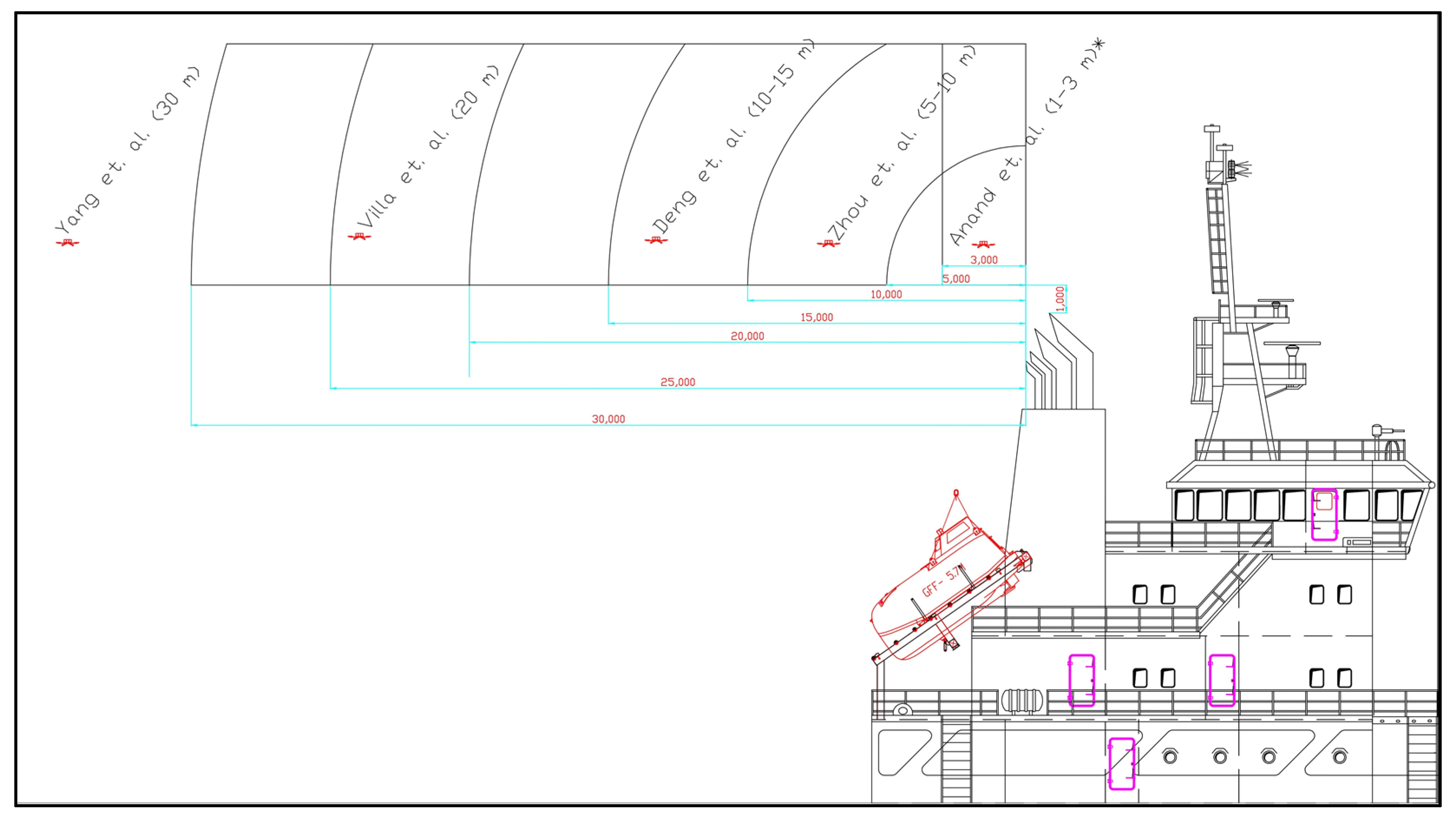
2.1. Measurement Distance from Ship

One important parameter for UAV-based FSC measurement, as mentioned by Zhou, is the distance from the ship’s stack [37], as detection accuracy decreases with increasing distance due to dilution of exhaust gas [46]. The description of how close a UAV should be to perform accurate FSC measurements is not conclusive in the current literature. Many authors describe the positioning of the UAV downwind from the ship’s stack, in a position where it would be close enough to interact with the plume and take measurements [28,30,39,43]. However, distance is an important factor not only for the accuracy of the measurement but also for safety. Deng pointed out a safety distance of 10–15 m. from the ship’s stack and 1–2 m. above the ship’s stack [47], while Zhou described a 5–10 m. range as suitable for UAV FSC measurement [37], and Yang suggested a 30 m. distance [49]. Furthermore, Yang and Anand also suggested that while in the exhaust gas plume the UAV should fly in a zigzag pattern, to ensure quality measurements [49,50]. In other measurement cases, where the FSC was not the main objective, the measurement distance varied. In the case of Villa, where particle emissions from a vessel were measured, an automated system with distance sensing capabilities was used, carrying out measurements at distances ranging from 20 to 100 m. from the vessel stack, and concluded that a 20 m. distance downwind is optimal [29]. A visualization of the measuring distances is presented in Figure 2.
From the reviewed research (Table 1), it can be noted that the safe distance for reliable measurement should be within the range of 10–30 m. However, it should also be noted that the lack of a common methodological description of distance for UAV-based measurement can be attributed to the fact that not all UAV models can measure or display the distance to an object, making the determination of exact distance, even with low accuracy, close to impossible and relying on the skill and awareness of the UAV operator to ensure a safe distance. With newer, more expensive models, the distance to objects can be tracked and measured, as in the case of Villa [29]. Furthermore, it was suggested by Yang to use a thermal imaging camera to determine the direction of movement for the exhaust gas plume. Such data can support the measurement both by sustaining the fixed distance for accurate and repeatable measurements, as well as reducing the risk of collisions.

2.2. Duration of Measurements

The second important parameter is the duration of measurement since longer measurements can ensure a better reliability of the results. However, since the UAV flight duration is limited by battery capacity, it is necessary to have an optimal measurement duration to be able to measure multiple ships. This parameter varies in different publications, ranging from 1 min to long measurements exceeding 30 min [28,37,39,42,47,58].
For the most common use, FSC measurement, as stated by Peng, the measurement has to be more than 2 min, but the actual measurement duration differs for each ship [42]. In the case of Peng, it ranged from 3.5 to 8 min, and in the case of Zhou, was about 5 min [39]. Anand noted that at least 30 s. is necessary to ensure a reliable response from sensors [50]. In several other cases, the differences between measurements were much larger; for example, Deng’s measurements ranged from 2.2 to 16.40 min. Even longer measurement periods, although not directly stated by the author, were displayed in the measurement charts, showing durations of 23 to 41 min [37]. Overall, it can be observed that practical application ranges roughly from 2 to 17 min, and longer in some cases. It should also be noted that, as with distance, practical application differs on a case-by-case basis and largely depends on the skill of the operator, the response time of the sensors, measurement methodology, and other influencing parameters (such as vessel properties, weather conditions, geographical location, etc.). As with the distance to the ship, the variations in measurement durations reflect the lack of standardization in UAV-based ship exhaust measurement.

2.3. Measurement Accuracy, Reliability and Uncertainties

The following two types of sensors are mostly used in UAV modules: NDIR—non-dispersive infrared and electrochemical sensors. The NDIR method uses 4.26 micron absorption wavelength to determine the presence of target gas. Infrared light is sent from one end of a test chamber towards the other end. As the amount of CO2 entering the chamber increases, the amount of infrared light travelling through the chamber decreases. The sensor measures this decrease in intensity. The higher the intensity of CO2, the higher the CO2 content in the environment [59]. The EC (electrochemical) method is used for SO2 concentration measurement. The sensor measures by reacting with the SO2 gas and generating an electrical signal proportional to the gas concentration. The sensors use very little power and show a good response to various gas concentrations over a wide range of ambient conditions [60,61]. Measurement sensor accuracy is presented in Table 2. For CO2 measurements, usually, an NDIR sensor with ranges of 0 to 10,000 ppm and a measurement accuracy of 5 to 300 ppm is used [28,30,39,45,46,47]. For SO2, electrochemical sensors are used with ranges that vary greatly, from 0 to 1 ppm [30,41,47] from 0 to 1000 ppm [46]. Measurement accuracy ranges from 5 ppb to 5 ppm [30,39,41,45,47]. For PM2.5 laser scattering (LS) and for PM10, the light scattering (LS) method is used (Table 2). In some cases, authors did not provide the range and/or accuracy of the device [40,42,46]. The uncertainties measured by the authors mostly include the two previously mentioned points–duration of measurement and distance, or rather the position of the UAV relative to the plume [37]. Some attempts are being made to specifically target the methodological problems and uncertainties in the measurement of exhaust gas plumes with UAVs. Anand performed extensive calibrations and also analyzed cross-sensitivity effects with other gases for the SO2 sensor and suggested a correction factor evaluation method, to ensure the quality of the results [48,50,58,62,63]. An improvement in plume detection for UAVs was proposed by Zhou and Yuan, where the mathematical modeling of the exhaust gas plume dispersion was used to preliminarily indicate the position of the plume, allowing determination of the UAV position for effective analysis [27,46]. This not only improves analysis but can, at least in part, be used to remove the need for a UAV operator to monitor and decide if the UAV was positioned correctly for plume analysis. A further improvement was also offered by Fan Zhou and others for the effective determination of the background concentration of CO2. The suggestion was to lift the UAV to 100 m (the legal limit in Europe and China is 120 m [64,65], additional regulations exist in the EU and can vary depending on the country [66]) and perform background concentration measurements, and after lowering the UAV to operation altitude, perform the measurements [37,45].
Another factor to consider is the influence of the UAV itself on the measurement equipment and measurement accuracy. This is not widely discussed; some work has been completed analyzing the influence of turbulence and air currents from the UAV propellers on the measurement accuracy [67,68,69]. It was found that moving sensors away from the UAV, or using a probe and positioning it vertically up, improves accuracy. It was also suggested that correction factors can be used in calibration to correct the results in case of using equipment without a probe [67,68,69]. Another factor in UAV use is vibration from the moving parts of the UAV [70,71]. Even though vibration can alter equipment performance or longevity, at the time of this review, no works discussing the influence of vibration on air pollution measurement equipment were found. It should be noted, though, that the influence of vibration can partially be resolved by using vibration dampening mounts, as provided by some manufacturers [38].
Sensor calibration is also an extremely important factor for ensuring accurate measurements. However, in most cases, the description of calibration procedure and or the calibration data are often omitted from the publications. In some cases, like in Zhou, the procedure for zero calibration before measurement is described [37]. Much more detailed descriptions of sensor calibration procedure were presented by Yang et al. [49] and Anand et al. [50]. In these studies, sensor calibration was carried out using stationary gas analyzers, a mixing chamber, and a gas control system [50]. In most cases, it is assumed that the sensors are calibrated correctly and no data on calibration are presented. It should also be noted that this, in part, could be because some of the drone-based equipment comes pre-calibrated from the manufacturer and may not be able to be calibrated by the user.

2.4. Influence of Airflow on UAV-Based Exhaust Gas Measurements

The diffusion and distribution of airflow near a ship’s stack is a contributing factor in measuring exhaust gases with UAVs. While this effect is lessened in most cases because measurements often target the fuel sulfur content (FSC), where dilution is less critical than in direct measurement, it remains relevant. Most studies on exhaust gas flow from ship stacks have focused on ship design, examining the impact of exhaust gases on ship construction and crew wellbeing [72,73,74,75]. A review of the literature indicates that most exhaust gas is dispersed directly behind or along the ship’s path, with only a minor fraction remaining at the ship’s stern and eventually diffusing backward [72,73,75].
Another important factor for remote measurement, as noted by Sunho Park, is the height of the ship’s stack [75]. However, since UAVs can adjust their measurement height freely, unlike stationary installations, this factor does not significantly influence UAV-based measurements. Additionally, exhaust gas temperature could potentially affect measurement accuracy or damage equipment, with temperatures at the engine exceeding 350 °C. However, research by Sunho Park et al. showed that exhaust gas temperature is about 18–20 °C at 1.5 m from the ship’s stack at 85% main engine load [72], considering the measurement distance range, based on different research, is 5–30 m, no damage to the equipment should occur.
Table 2. Methods of pollutants for measuring range and detection accuracy.
Author, YearMount LocationSensor ModelSensor Measuring RangeDetection Accuracy
Fan Zhou et al., 25 November 2019 [37]Under UAV, probe outside UAVCO2 sensor NDIR method0–5000 ppm±50 ppm.
SO2 sensor EC method.0–5 ppm±0.25 ppm
Jianbo Hu et al., 2022 [30], Mengtao Deng et al., 2022 [41], Mengtao Deng et al., 2022 [47]Under UAV, no probe SO2 SGA-700B-SO2,
CO2: SGA-700B-CO2.
0–1 ppm
0–2000 ppm
±10 ppb.
±5 ppm
Fan Zhou et al., 2019 [28]Under UAV, probe outside UAVSO2 sensor EC method0–100 ppm±5 ppm
NO2 sensor EC method
Fan Zhou et al., 2020 [39]Under UAV, probe outside UAVSO2 sensor EC method.0–10 ppm±3%
CO2 sensor NDIR method.0–10,000 ppm±3%
Sudum Esaenwi et al., 2023 [40]On UAV, no probe MQ131 Ozone sensor. [76]10–1000 ppm [77]not provided.
Xin Peng et al., 2021 [42]Under UAV, probe outside UAVCO2 not provided0–2000 ppmnot provided.
SO2 sensor EC method0–200 ppmnot provided.
Tommaso F. Villa et al., 2019 [29]Under UAV, probe outside UAVCO2 sensor NDIR method.0–5000 ppm±50 ppm
Fan Zhou et al., 2019 [45]Under UAV, probe outside UAVCO2 sensor NDIR method.0–5000 ppm±50 ppm
SO2 sensor EC.0–5 ppm±0.25 ppm
Haiwen Yuan et al., 2020 [46]Under UAV, no probeNO, NO2, SO20–1000not provided.
CO2 sensor0–2000 (unit: mg/m3).not provided.
Shiyi Yang et al. [49]On UAVm with probe under UAVSO2, sensor EC, CO2 sensor NDIR--
Abhishek Anand et al. [50]On UAVm with probe under UAVSO2, NO, CO sensor EC, CO2 sensor NDIR--
The review of publications (Table 1 and Table 2) shows that the positioning of the device did not provide any clear tendencies. Both approaches (mount location–under UAV or on top, sampling probe extending outside of UAV and with no sampling probe) are used effectively for ship plume analysis. It should also be mentioned that even though in cases of ship exhaust gas plume analysis both equipment with probes and without are used effectively, in other areas, studies have shown that UAV propellers can cause the dispersion of gas if sensors are mounted on the top or bottom of the UAV, and moving sensors away from the rotors can improve accuracy. Additional work should be completed in terms of calibration and sensor positioning to resolve this problem [24,67].

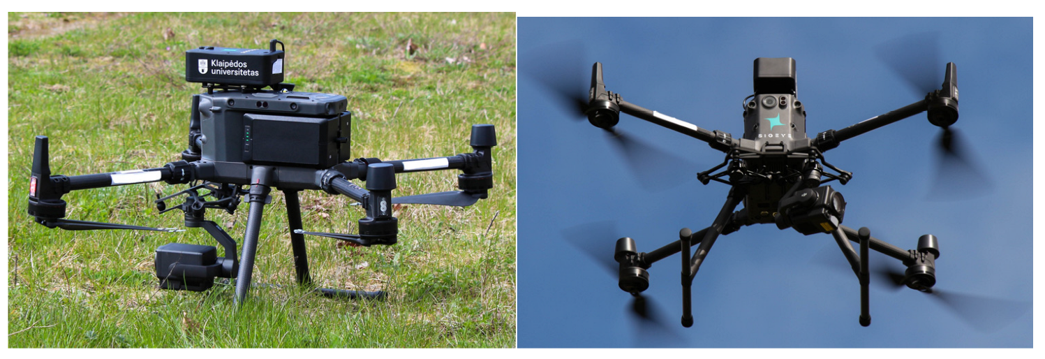
2.5. UAV Characteristics

During the flights where ship air pollutant emissions can occur at a significant distance from the coast, it is logical that UAVs with a significant flight distance and load capacity for the measurement equipment should be used. Furthermore, measurements at sea can lead to greater winds, so sufficient wind resistance is also expected.
The literature review highlighted the UAV characteristics, with each UAV shown in Table 3 [63,64,65,77,78,79,80,81]. The most essential parameters used in UAVs are maximum wind resistance (m/s), flight distance (m), and maximum payload (kg). The most common ones are from the manufacturer DJI, with a flight range ranging from 5 to 10 km. The maximum wind resistance reaches 8–10 m/s. The maximum payload in most cases reaches 5 to 6 kg. In rare cases, the maximum payload is 0.5 kg. The most commonly used UAV models were the Matrice 600 and Matrice 600 PRO [27,28,37,39,43,45]. These two UAVs are capable of carrying a payload of up to 6 kg, with the same maximum wind resistance of 8 m/s and flight distance of 5000 m. The second most commonly used UAV is the DJI Phantom 4 Pro V2.0 [30,41,47]. Its maximum wind resistance reaches 10 m/s, maximum payload reaches 0.5 kg, and flight distance is 10,000 m.
Even though the most common use of UAVs in ship air pollution measurement involves SO2 and CO2 measurement, the capabilities of UAV-based measurement stations available on the market are quite extensive. The range of measured elements of newly introduced products is wide and includes pollutants created not only in shipping but also in other industries. Considerable attention is directed towards ensuring safety in companies where UAVs are used to monitor leaks of hazardous substances such as methane or toxic gases in large areas. UAVs are also highlighted as an advanced tool for environmental monitoring, including ships. The measured elements of UAV-mounted equipment available on the market include CO2, CO, SO2, NO2, NO, PM2.5, PM10, O3, and more. Measuring ranges for more common use are CO2 1–2000 ppm with a resolution of 0.6 ppm, SO2 measuring range 0–2000 ppm, and NO measuring range 0.01–1 ppm with a resolution of 0.001 ppm, respectively. In terms of positioning, different variations exist (top and bottom of UAV, with and without a sampling probe). In most cases, the measuring equipment is compatible with DJI UAVs (DJI MATRICE 210, V2, 300, 600, S1000), whose specifications are provided in Table 4.

2.6. UAV Autonomy and Scheduling

Measuring ship exhaust gases with UAVs requires skilled operators and can be extremely labor-intensive, especially on a large scale. This challenge is well-known, and efforts are being made to automate the process, including the development of scheduling systems and automated measurement techniques [48,51,52,53,63]. A primary focus of this research is in optimizing the analysis to measure as many ships as possible within limited flight times. This is achieved by employing various algorithms, such as genetic algorithms and artificial bee colony (ABC) algorithms, for flight planning.
However, while these research papers address a critical aspect of the problem, they do not fully resolve the primary challenge: controlling UAVs during plume measurement to ensure safe operation and adequate data collection. The issue of autonomous plume measurement remains unresolved, necessitating the continued reliance on skilled operators. Additionally, none of these studies have been field-tested and typically rely solely on numerical experiments with several assumptions, making their adaptation to field conditions even more difficult. A somewhat similar situation exists with active ship tracking. The autonomous tracking of a moving vessel is necessary not just to perform measurements autonomously, but to avoid collisions and maintain a fixed distance between the vessel and UAV. The current literature on the subject usually targets two problems: tracking/recognition of a vessel and landing on a vessel. Landing on a vessel typically requires a special platform or specific markings on a landing location that can be recognized by the drone camera, along with significant effort to develop an algorithm for safe landing on an unstable platform. However, since it relies heavily on special markings, this approach is not applicable to the pollution measurement problem, as no special markings will be available on a random passing ship.
Ship tracking research is not widely analyzed in the scientific literature, with only a few papers available at the time of this review [88,89]. These papers emphasize two different approaches: Kazantsev et al. suggested the visual recognition of vessels from video feeds, an approach well-known and implemented in modern UAVs for different object tracking [90,91,92]. Another approach suggested by Garcia-Aunon relied on military application algorithms from homing missiles adapted for UAV operation [89]. While these studies, as well as current UAV technologies, show a capability for ship tracking, there still is a lack of methodology for positioning UAVs in ships’ exhaust gas plumes for measurement. A more collaborative effort from researchers in different fields is necessary to bridge the gap between optimization and real-world measurement applications.
Some methodological frameworks outlining the principles for ship exhaust gas plume measurement have already been put forward by Anand et al. [50], specifying the measurement conditions (distance, duration, etc.) that could be integrated into optimization and automation algorithms. Similarly, Karachalios [53] has presented efforts to automate adaptation to wind conditions during measurement. However, at the time of this review, no works have demonstrated autonomous UAV-based ship plume measurement.

2.7. Legal Regulation in the EU

UAV operation in the EU is governed by the European Union Aviation Safety Agency (EASA) [93]. According to EASA rules, UAV operations are divided into three categories: open category (low risk), specific category (increased risk), and certified category (high risk) [94]. Most UAV flights fall under the open category, which does not require authorization from National Aviation Authorities (NAAs). This category is further divided into subcategories: A1—fly over people but not over assemblies of people; A2—fly close to people; A3—fly far from people. UAVs are classified into “C” classes, with higher classes corresponding to higher mass [93]. Most UAVs used in air pollution research belong to subcategory A2, class C2 (<4 kg) or subcategory A3, or classes C3–C4 (<25 kg), where flights must occur far from people [93,94]. Since shipping pollution measurements typically take place over water, except when measuring pollutants from ships during hoteling, and at some distance from the measured vessel, these measurements are usually not affected unless conducted in port. The maximum allowed altitude for UAVs is 120 m, and they must maintain a safe distance from airports, military areas, and other sensitive locations. Additionally, UAVs must be flown within the visual line of sight (VLOS). Information about areas where UAV operation is prohibited or requires special permissions is often available online [88].
The specific category includes operations with larger UAVs or small UAVs flying over densely populated areas. This category requires an operational authorization (OA) issued by the NAA, with specific limitations based on the risk posed by the operation [95].
Examples of UAV operations in the ‘specific’ category include [95]:
  • BVLOS: beyond visual line of sight.
  • MTOM > 25 kg: when using a drone with a maximum takeoff mass greater than 25 kg.
  • Altitude: flying higher than 120 m above ground level.
  • Dropping Materials: when dropping any material.
  • Urban Operations: operating a drone in an urban environment with an MTOM > 4 kg or without a class identification label.
For UAV operations in the specific category, the UAV operator must obtain authorization from the National Aviation Authority (NAA) of the state of registration before starting the flight. Even if the operation is to be conducted in a different state, authorization is issued by the NAA of the state of registration. The requirements for UAV pilots in the European Union include:
  • holding an EU drone license when flying a drone above 249 g;
  • possessing a drone operator number (exceptions apply for toy drones) [95,96].
A key legal distinction is that autonomous, scheduled UAVs could fall into a different category. Most open category flights require visual line of sight (VLOS), where the operator can see and directly control the UAV. Autonomous flights, which are BVLOS, may require additional authorization and clarification, especially for future autonomous measurement research. In addition, national requirements vary from country to country and might significantly limit UAV operation.

2.8. The Future Work and Trends

Considering how fast UAVs have evolved in leisure, professional, industrial, and scientific use, it is clear that the rapid evolution of UAV-based systems will continue. It is expected that the UAV market will expand to USD 54.6 billion [97]. Among the mentioned developments, there is an increase in UAV navigation and decision-making capabilities by adding advanced AI systems, computer vision, and obstacle avoidance capabilities [91,92,96,97,98,99,100,101]. Another important trend is the powering of UAVs, since flight times with current battery technology are still fairly limited (see Table 3). Developments are being made to improve this by using hydrogen fuel cells instead of batteries, which could extend flight times to several hours [102,103].
Significant progress is still needed in air pollution measurement within the shipping industry. Some of the reviewed works have made commendable strides towards establishing common methodologies and solutions. While the fundamental principles of using electrochemical, NDIR, and optical sensors are well understood, the optimal positioning of equipment for best sampling practices remains unclear. This necessitates further development of standard equipment positioning by both researchers and equipment manufacturers.
Regarding UAVs, it is notable that most researchers have used various iterations of the DJI series. This consistency could benefit equipment developers, as adaptations are required for only one group of UAVs. However, there is a clear lack of methodological work aimed at developing unified methodologies for ship exhaust gas plume analysis. Some recent studies have pointed in the right direction by developing methodological principles for measurement, but much work remains to be achieved [50].
Automated or semi-automated measurement systems could significantly enhance comparability and measurement quality. While numerous efforts have been made in this direction, the work is often fragmented, with teams addressing various issues such as scheduling, tracking, and plume location identification independently. This fragmentation has resulted in a lack of unified solutions. A concerted effort from different teams is essential to integrate mathematical modeling solutions into practical applications, thereby bridging the gap between theory and practice. Furthermore, it is crucial to address the legal aspects of autonomous UAV measurements to ensure their successful implementation, since running UAVs autonomously taking measurements in high-risk areas, such as ports and harbors, is risky and requires clear regulation [44,104,105].

3. Conclusions

Unmanned aerial vehicles (UAVs) equipped with inexpensive yet precise air quality sensors are becoming increasingly accessible, opening up opportunities for the wider utilization of these technologies in air quality monitoring. This is particularly beneficial for gaining insights into the vertical distribution of pollutants, facilitating the search and detection of emission sources, and monitoring and verifying pollution distribution around fixed locations such as ports or industrial complexes.
Considering the results of the literature analysis, it can be concluded that most air pollutant analyses conducted on ships are focused on fuel sulfur content (FSC), with analyses and methodologies for other pollutants being very rare, particularly in the context of European countries.
One of the most commonly used methods for measuring concentrations on ships is the sniffing method, wherein sensors are mounted on a module attached to a UAV, and gas analysis is performed directly by the device. This method involves flying the UAV to a precise location near the ship. However, the distance to the ship and the positioning of the UAV relative to the plume remain uncertain, as differences between studies make it difficult to compare and underscore the need for the development of common standards and methodologies. Currently, significant efforts are being made by researchers to formulate solutions for this problem by providing UAV routing and positioning algorithms that will lay a solid foundation for future standardization.
The analysis of device locations has shown that all mounting locations (top, bottom, with or without a probe) are effectively used for analysis, especially for FSC. However, there is evidence to suggest that relocating the measurement device or using a probe to position sampling vertically above the drone can reduce the influence of wind currents formed by the propeller blades.
Upon analyzing the current trends in UAVs and their related system developments, it is evident that UAVs are poised to become increasingly versatile tools in the near future. This evolution will entail extended flight times, heightened autonomy in measurements, reducing reliance on operators, and a shift towards fully autonomous measurement systems.

Author Contributions

Conceptualization of the review topic and structure, P.R.; methodology, P.R. and L.Š.; analysis, L.Š. and V.D.; investigation, L.Š. and V.D.; resources, P.R.; writing—original draft preparation, P.R. and L.Š.; writing—review and editing, P.R.; visualization, L.Š.; funding acquisition, P.R.. All authors have read and agreed to the published version of the manuscript.

Funding

This research was funded by the Lithuanian Research Council and the Ministry of Education, Science and Sports of the Republic of Lithuania (Project No. S-A-UEI-23-9).

Data Availability Statement

No new data were created or analyzed in this study. Data sharing is not applicable to this article.

Conflicts of Interest

The authors declare no conflict of interest.

References

  1. Wang, S.; Wang, X.; Han, Y.; Wang, X.; Jiang, H.; Duan, J.; Hua, R.; Zhang, Z. Decarbonizing in Maritime Transportation: Challenges and Opportunities. J. Transp. Technol. 2023, 13, 301–325. [Google Scholar] [CrossRef]
  2. Irvana, R.; Abdullah, K.; Sadirsan, E.S. Transformation of Monohull to Catamaran Hybrid (Diesel-PV) Fishing Vessels to Reduce Exhaust Emissions. Int. J. Mar. Eng. Innov. Res. 2022, 7, 261–269. [Google Scholar] [CrossRef]
  3. Liu, X. The Supervision and Multi-Sectoral Guarantee Mechanism of the Global Marine Sulphur Limit—Assessment from Chinese Shipping Industry. Front. Mar. Sci. 2022, 9, 1028388. [Google Scholar] [CrossRef]
  4. Ramacher, M.O.P.; Karl, M.; Bieser, J.; Jalkanen, J.-P.; Johansson, L. Urban Population Exposure to NOx Emissions from Local Shipping in Three Baltic Sea Harbour Cities—A Generic Approach. Atmos. Chem. Phys. Discuss. 2019, 19, 9153–9179. [Google Scholar] [CrossRef]
  5. Kuittinen, N.; Jalkanen, J.-P.; Alanen, J.; Ntziachristos, L.; Hannuniemi, H.; Johansson, L.; Karjalainen, P.; Saukko, E.; Isotalo, M.; Aakko-Saksa, P.; et al. Shipping Remains a Globally Significant Source of Anthropogenic PN Emissions Even after 2020 Sulfur Regulation. Environ. Sci Technol 2021, 55, 129–138. [Google Scholar] [CrossRef]
  6. European Parliament Brussels. 17.9.2020 COM(2020) 562 Final Communication from the Commission to the European Parliament, the Council, the European Economic and Social Committee and the Committee of the Regions Stepping up Europe’s 2030 Climate Ambition Investing in a Climat; European Parliament: Brussels, Belgium, 2020. [Google Scholar]
  7. IMO. Annex 11 Resolution Mepc.304(72) (Adopted on 13 April 2018) Initial IMO Strategy on Reduction of GHG Emissions from Ships. 2018. Available online: https://wwwcdn.imo.org/localresources/en/KnowledgeCentre/IndexofIMOResolutions/MEPCDocuments/MEPC.304(72).pdf (accessed on 11 June 2024).
  8. Marine Environment Protection Committee IMO. Available online: https://www.imo.org/en/MediaCentre/MeetingSummaries/Pages/MEPC-80.aspx (accessed on 26 April 2024).
  9. Sustainable Maritime Fuels “Fit for 55” Package: The FuelEU Maritime Proposal. 2023. Available online: https://www.europarl.europa.eu/thinktank/en/document/EPRS_BRI(2021)698808 (accessed on 5 March 2024).
  10. Mallouppas, G.; Yfantis, E.A. Decarbonization in Shipping Industry: A Review of Research, Technology Development, and Innovation Proposals. J. Mar. Sci. Eng. 2021, 9, 415. [Google Scholar] [CrossRef]
  11. Mukherjee, A.; Bruijnincx, P.C.; Junginger, M. A Perspective on Biofuels Use and CCS for GHG Mitigation in the Marine Sector. iScience 2020, 23, 101758. [Google Scholar] [CrossRef]
  12. Speizer, S.; Fuhrman, J.; Aldrete, L.; George, M.; Kyle, P.; Monteith, S.; McJeon, H. A Zero-Emissions Global Transportation Sector: Advanced Technologies and Their Energy and Environmental Implications. Preprint 2023. [Google Scholar] [CrossRef]
  13. De, A.; Choudhary, A.; Tiwari, M.K. Multiobjective Approach for Sustainable Ship Routing and Scheduling with Draft Restrictions. IEEE Trans. Eng. Manag. 2019, 66, 35–51. [Google Scholar] [CrossRef]
  14. Chen, X.; Lv, S.; Shang, W.; Wu, H.; Xian, J.; Song, C. Ship Energy Consumption Analysis and Carbon Emission Exploitation via Spatial-Temporal Maritime Data. Appl. Energy 2024, 360, 122886. [Google Scholar] [CrossRef]
  15. Liu, Z.; Lu, X.; Feng, J.; Fan, Q.; Zhang, Y.; Yang, X. Influence of Ship Emissions on Urban Air Quality: A Comprehensive Study Using Highly Time-Resolved Online Measurements and Numerical Simulation in Shanghai. Environ. Sci. Technol. 2017, 51, 202–211. [Google Scholar] [CrossRef]
  16. Mocerino, L.; Murena, F.; Quaranta, F.; Toscano, D. A Methodology for the Design of an Effective Air Quality Monitoring Network in Port Areas. Sci. Rep. 2020, 10, 300. [Google Scholar] [CrossRef]
  17. European Maritime Safety Agency Sulphur Inspection Guidance Directive (EU) 2016/802; European Commission: Brussels, Belgium, 2016.
  18. IMO. IMO2020 Fuel Oil Sulphur Limit-Cleaner Air, Healthier Planet. Available online: https://www.imo.org/en/MediaCentre/PressBriefings/Pages/02-IMO-2020.aspx (accessed on 8 May 2024).
  19. IMO. Annex 3 Resolution mepc.326(75) (Adopted on 20 November 2020) 2020 Guidelines for Monitoring the Worldwide Average Sulphur Content of Fuel Oils Supplied for Use on Board Ships. Available online: https://wwwcdn.imo.org/localresources/en/KnowledgeCentre/IndexofIMOResolutions/MEPCDocuments/MEPC.326(75).pdf (accessed on 5 March 2024).
  20. Li, X.; Li, K.; Ji, Q.; Shen, F.; Wu, Q.; Chen, Q.; Luo, L.; Bian, X.; Chen, W.; Lou, D. Investigation of Sniffer Technique on Remote Measurement of Ship Emissions: A Case Study in Shanghai, China. PLoS ONE 2022, 17, e0274236. [Google Scholar] [CrossRef]
  21. TELOPS. Remote Quantification of Sulfur Content in Fuel from SO2 Quantification from Ship Exhaust Plume. 2020. Available online: https://www.telops.com/wp-content/uploads/2021/11/remotequantificationofsulfurcontentinfuel_appnote.pdf (accessed on 24 May 2024).
  22. Peng, X.; Li, T.; Wu, L.; Huang, L.; Wen, Y.; Zhou, C.; Zhang, F.; Han, T.; Li, J. Optimal Site Selection for the Remote-Monitoring Sulfur Content of Ship Fuels in Ports. Ocean Coast. Manag. 2022, 225, 106211. [Google Scholar] [CrossRef]
  23. Zhao, T.; Chen, M.; Lee, H. A Study on the Framework for Estimating Ship Air Pollutant Emissions—Focusing on Ports of South Korea. Atmosphere 2022, 13, 1141. [Google Scholar] [CrossRef]
  24. Villa, T.; Salimi, F.; Morton, K.; Morawska, L.; Gonzalez, F. Development and Validation of a UAV Based System for Air Pollution Measurements. Sensors 2016, 16, 2202. [Google Scholar] [CrossRef]
  25. Valavanis, K.P. (Ed.) Advances in Unmanned Aerial Vehicles; Springer: Dordrecht, The Netherlands, 2007; ISBN 978-1-4020-6113-4. [Google Scholar]
  26. Motlagh, N.H.; Kortoci, P.; Su, X.; Loven, L.; Hoel, H.K.; Haugsvaer, S.B.; Srivastava, V.; Gulbrandsen, C.F.; Nurmi, P.; Tarkoma, S. Unmanned Aerial Vehicles for Air Pollution Monitoring: A Survey. IEEE Internet Things J. 2023, 10, 21687–21704. [Google Scholar] [CrossRef]
  27. Zhou, F.; Zhu, L.; Zou, J.; Bai, X. Tracking and Measuring Plumes from Sailing Ships Using an Unmanned Aerial Vehicle. IET Intell. Transp. Syst. 2023, 17, 285–294. [Google Scholar] [CrossRef]
  28. Zhou, F.; Gu, J.; Chen, W.; Ni, X. Measurement of SO2 and NO2 in Ship Plumes Using Rotary Unmanned Aerial System. Atmosphere 2019, 10, 657. [Google Scholar] [CrossRef]
  29. Villa, T.F.; Brown, R.A.; Jayaratne, E.R.; Gonzalez, L.F.; Morawska, L.; Ristovski, Z.D. Characterization of the Particle Emission from a Ship Operating at Sea Using an Unmanned Aerial Vehicle. Atmos. Meas. Tech. 2019, 12, 691–702. [Google Scholar] [CrossRef]
  30. Hu, J.; Deng, M.; Peng, S.; Qi, Z. UAV Inspection of Compliance of Fuel Sulfur Content of Sailing Ships in the Pearl River Delta, China. Atmosphere 2022, 13, 1894. [Google Scholar] [CrossRef]
  31. Cooper, D.A. Exhaust Emissions from Ships at Berth. Atmos. Environ. 2003, 37, 3817–3830. [Google Scholar] [CrossRef]
  32. Marpol Marpol Annex VI Fuel Sulphur Content Limitation. Available online: https://www.imo.org/en/MediaCentre/PressBriefings/Pages/10-MEPC-74-sulphur-2020.aspx (accessed on 19 March 2024).
  33. IMO Global Sulphur Regulations/ECA/SECA Zones. Available online: https://www.maritimeoptima.com/insights/global-sulphur-regulations-eca-seca-zones (accessed on 2 July 2024).
  34. ABS Advisory on NOx Tier III Compliance. Available online: https://ww2.eagle.org/content/dam/eagle/advisories-and-debriefs/ABS-Advisory-on-NOx-Tier-III-Compliance-20068.pdf (accessed on 20 March 2024).
  35. Rapalis, P.; Šilas, G.; Žaglinskis, J. Ship Air Pollution Estimation by AIS Data: Case Port of Klaipeda. J. Mar. Sci. Eng. 2022, 10, 1950. [Google Scholar] [CrossRef]
  36. Yang, L.; Zhang, Q.; Zhang, Y.; Lv, Z.; Wang, Y.; Wu, L.; Feng, X.; Mao, H. An AIS-Based Emission Inventory and the Impact on Air Quality in Tianjin Port Based on Localized Emission Factors. Sci. Total Environ. 2021, 783, 146869. [Google Scholar] [CrossRef]
  37. Zhou, F.; Pan, S.; Chen, W.; Ni, X.; An, B. Monitoring of Compliance with Fuel Sulfur Content Regulations through Unmanned Aerial Vehicle (UAV) Measurements of Ship Emissions. Atmos. Meas. Tech. 2019, 12, 6113–6124. [Google Scholar] [CrossRef]
  38. Purway Prophet AM Air Monitoring Module 2023, 1–25. Available online: https://purway-innovate.com/ (accessed on 2 June 2024).
  39. Zhou, F.; Hou, L.; Zhong, R.; Chen, W.; Ni, X.; Pan, S.; Zhao, M.; An, B. Monitoring the Compliance of Sailing Ships with Fuel Sulfur Content Regulations Using Unmanned Aerial Vehicle (UAV) Measurements of Ship Emissions in Open Water. Atmos. Meas. Tech. 2020, 13, 4899–4909. [Google Scholar] [CrossRef]
  40. Esaenwi, S. Development of Smart UAV (Drone) Ozone (O3) Monitoring System in Port Harcourt, Rivers State, Nigeria. World J. Adv. Res. Rev. 2023, 17, 558–568. [Google Scholar] [CrossRef]
  41. Deng, M.; Peng, S.; Xie, X.; Jiang, Z.; Hu, J.; Qi, Z.; Sun, J. SO2 Compliance Monitoring and Emission Characteristics Analysis of Navigating Ships: A Case Study of Shanghai Waters in Emission Control Areas, China. Atmos. Pollut. Res. 2022, 13, 101560. [Google Scholar] [CrossRef]
  42. Peng, X.; Huang, L.; Wu, L.; Zhou, C.; Wen, Y.; Chen, H.; Xiao, C. Remote Detection Sulfur Content in Fuel Oil Used by Ships in Emission Control Areas: A Case Study of the Yantian Model in Shenzhen. Ocean. Eng. 2021, 237, 109652. [Google Scholar] [CrossRef]
  43. Haugen, M.J.; Gkantonas, S.; Helou, I.E.; Pathania, R.; Mastorakos, E.; Boies, A.M. Measurements and Modelling of the Three-Dimensional near-Field Dispersion of Particulate Matter Emitted from Passenger Ships in a Port Environment. Atmos. Environ. 2022, 290, 119384. [Google Scholar] [CrossRef]
  44. Hu, Z.H.; Liu, T.C.; Tian, X.D. A Drone Routing Problem for Ship Emission Detection Considering Simultaneous Movements. Atmosphere 2023, 14, 373. [Google Scholar] [CrossRef]
  45. Zhou, F.; Pan, S.; Chen, W.; Ni, X.; An, B. High-Precision Monitoring of Compliance with Fuel Sulfur Content through UAV Measurements of Ship Emissions. Atmos. Meas. Tech. Discuss. 2019, 12, 6113–6124. [Google Scholar] [CrossRef]
  46. Yuan, H.; Xiao, C.; Wang, Y.; Peng, X.; Wen, Y.; Li, Q. Maritime Vessel Emission Monitoring by an UAV Gas Sensor System. Ocean Eng. 2020, 218, 108206. [Google Scholar] [CrossRef]
  47. Deng, M.; Peng, S.; Xie, X.; Jiang, Z.; Hu, J.; Qi, Z. A Diffused Mini-Sniffing Sensor for Monitoring SO2 Emissions Compliance of Navigating Ships. Sensors 2022, 22, 5198. [Google Scholar] [CrossRef]
  48. Bao, X.; Hu, Z.; Huang, Y. Routing a Fleet of Drones from a Base Station for Emission Detection of Moving Ships by Genetic Algorithm. J. Mar. Sci. Eng. 2024, 12, 891. [Google Scholar] [CrossRef]
  49. Yang, S.; Ghadikolaei, M.A.; Gali, N.K.; Xu, Z.; Chu, M.; Qin, X.; Ning, Z. Evaluating Methods for Marine Fuel Sulfur Content Using Microsensor Sniffing Systems on Ocean-Going Vessels. Sci. Total Environ. 2024, 942, 173765. [Google Scholar] [CrossRef]
  50. Anand, A.; Wei, P.; Gali, N.K.; Sun, L.; Yang, F.; Westerdahl, D.; Zhang, Q.; Deng, Z.; Wang, Y.; Liu, D.; et al. Protocol Development for Real-Time Ship Fuel Sulfur Content Determination Using Drone Based Plume Sniffing Microsensor System. Sci. Total Environ. 2020, 744, 140885. [Google Scholar] [CrossRef]
  51. Shen, L.; Hou, Y.; Yang, Q.; Lv, M.; Dong, J.X.; Yang, Z.; Li, D. Synergistic Path Planning for Ship-Deployed Multiple UAVs to Monitor Vessel Pollution in Ports. Transp. Res. D Transp. Environ. 2022, 110, 103415. [Google Scholar] [CrossRef]
  52. Hu, Z.H.; Liu, T.C.; Tian, X.D. Scheduling Drones for Ship Emission Detection from Multiple Stations. Drones 2023, 7, 158. [Google Scholar] [CrossRef]
  53. Karachalios, T.; Moschos, P.; Orphanoudakis, T. Maritime Emission Monitoring: Development and Testing of a UAV-Based Real-Time Wind Sensing Mission Planner Module. Sensors 2024, 24, 950. [Google Scholar] [CrossRef]
  54. Pikun, W.; Ling, W.; Jiangxin, Q.; Jiashuai, D. Unmanned Aerial Vehicles Object Detection Based on Image Haze Removal under Sea Fog Conditions. IET Image Process 2022, 16, 2709–2721. [Google Scholar] [CrossRef]
  55. Vasilopoulos, E.; Vosinakis, G.; Krommyda, M.; Karagiannidis, L.; Ouzounoglou, E.; Amditis, A. A Comparative Study of Autonomous Object Detection Algorithms in the Maritime Environment Using a UAV Platform. Computation 2022, 10, 42. [Google Scholar] [CrossRef]
  56. Haugen, M.J.; Gkantonas, S.; Helou, I.E.; Pathania, R.; Mastorakos, E.; Boies, A.M. Particle Measurements from In-Use Maritime Traffic Using an Unmanned Aerial Vehicle in Rafina, Greece. Transp. Res. Procedia 2023, 72, 2094–2100. [Google Scholar] [CrossRef]
  57. Yan, M.; Yuan, H.; Xu, J.; Yu, Y.; Jin, L. Task Allocation and Route Planning of Multiple UAVs in a Marine Environment Based on an Improved Particle Swarm Optimization Algorithm. EURASIP J. Adv. Signal Process. 2021, 2021, 94. [Google Scholar] [CrossRef]
  58. Shen, L.; Wang, Y.; Liu, K.; Yang, Z.; Shi, X.; Yang, X.; Jing, K. Synergistic Path Planning of Multi-UAVs for Air Pollution Detection of Ships in Ports. Transp. Res. E Logist. Transp. Rev. 2020, 144, 102128. [Google Scholar] [CrossRef]
  59. Hamamatsu CO2 Measurement. Principle of CO2 measurement with NDIR method 2023, 1–4. Available online: https://www.hamamatsu.com/content/dam/hamamatsu-photonics/sites/documents/99_SALES_LIBRARY/ssd/an_co2_koth0026e.pdf (accessed on 2 July 2024).
  60. Han, P.; Mei, H.; Liu, D.; Zeng, N.; Tang, X.; Wang, Y.; Pan, Y. Calibrations of Low-Cost Air Pollution Monitoring Sensors for CO, NO2, O3, and SO2. Sensors 2021, 21, 256. [Google Scholar] [CrossRef] [PubMed]
  61. Arroyo, P.; Gómez-Suárez, J.; Suárez, J.I.; Lozano, J. Low-Cost Air Quality Measurement System Based on Electrochemical and PM Sensors with Cloud Connection. Sensors 2021, 21, 6228. [Google Scholar] [CrossRef] [PubMed]
  62. Xia, J.; Wang, K.; Wang, S. Drone Scheduling to Monitor Vessels in Emission Control Areas. Transp. Res. Part B Methodol. 2019, 119, 174–196. [Google Scholar] [CrossRef]
  63. Chen, J.; Wang, S.; Qu, X.; Yi, W. A Modelling Framework of Drone Deployment for Monitoring Air Pollution from Ships. In Intelligent Interactive Multimedia Systems and Services; Springer: Berlin/Heidelberg, Germany, 2019; pp. 281–288. [Google Scholar]
  64. Zheng, T.; Li, S.; Xiao, Z.J.; Zhang, L. The Optimization Model of UAV Shooting Flight Routes 2023. Preprint 2023. [Google Scholar] [CrossRef]
  65. Jones, L.R.; Elmore, J.A.; Krishnan, B.S.; Samiappan, S.; Evans, K.O.; Pfeiffer, M.B.; Blackwell, B.F.; Iglay, R.B. Controllable Factors Affecting Accuracy and Precision of Human Identification of Animals from Drone Imagery. Ecosphere 2023, 14, e4657. [Google Scholar] [CrossRef]
  66. Yıldız, S.; Kıvrak, S.; Arslan, G. Using Drone Technologies for Construction Project Management: A Narrative Review. J. Constr. Eng. Manag. Innov. 2021, 4, 229–244. [Google Scholar] [CrossRef]
  67. Alvarado, M.; Gonzalez, F.; Erskine, P.; Cliff, D.; Heuff, D. A Methodology to Monitor Airborne PM10 Dust Particles Using a Small Unmanned Aerial Vehicle. Sensors 2017, 17, 343. [Google Scholar] [CrossRef]
  68. Samad, A.; Florez, D.A.; Chourdakis, I.; Vogt, U. Concept of Using an Unmanned Aerial Vehicle (UAV) for 3D Investigation of Air Quality in the Atmosphere—Example of Measurements near a Roadside. Atmosphere 2022, 13, 663. [Google Scholar] [CrossRef]
  69. Szczurek, A.; Gonstał, D.; Maciejewska, M. The Gas Sensing Drone with the Lowered and Lifted Measurement Platform. Sensors 2023, 23, 1253. [Google Scholar] [CrossRef] [PubMed]
  70. Cocuzza, S.; Doria, A. Modeling and Identification of Vibrations in a UAV for Aerial Manipulation. In Advances in Italian Mechanism Science: Proceedings of the 3rd International Conference of IFToMM, Naples, Italy, 9–11 September 2020; Springer International Publishing: Cham, Switzerland, 2021; pp. 182–190. [Google Scholar]
  71. Al-Haddad, L.; Jaber, A.; Neranon, P.; Al-Haddad, S. Investigation of Frequency-Domain-Based Vibration Signal Analysis for UAV Unbalance Fault Classification. Eng. Technol. J. 2023, 41, 915–923. [Google Scholar] [CrossRef]
  72. Park, S.; Heo, J.; Yu, B.S.; Rhee, S.H. Computational Analysis of Ship’s Exhaust-Gas Flow and Its Application for Antenna Location. Appl. Therm. Eng. 2011, 31, 1689–1702. [Google Scholar] [CrossRef]
  73. Zhu, Y.; Wan, Q.; Hou, Q.; Feng, Y.; Yu, J.; Shi, J.; Xia, C. Analysis of Diffusion Characteristics and Influencing Factors of Particulate Matter in Ship Exhaust Plume in Arctic Environment Based on CFD. Atmosphere 2024, 15, 580. [Google Scholar] [CrossRef]
  74. Gan, L.; Lu, T.; Shu, Y. Diffusion and Superposition of Ship Exhaust Gas in Port Area Based on Gaussian Puff Model: A Case Study on Shenzhen Port. J. Mar. Sci. Eng. 2023, 11, 330. [Google Scholar] [CrossRef]
  75. Park, S.; Yang, J.; Rhee, S.H. Parametric Study on Ship’s Exhaust-Gas Behavior Using Computational Fluid Dynamics. Eng. Appl. Comput. Fluid Mech. 2017, 11, 159–171. [Google Scholar] [CrossRef]
  76. Winsen MQ131 Ozone Gas Sensor. Available online: https://www.winsen-sensor.com/product/mq131-h.html?searchid=5035 (accessed on 13 March 2024).
  77. DJI Drone Matrice 600 PRO Specifications. Available online: https://www.dji.com/lt/matrice600-pro/info (accessed on 7 March 2024).
  78. ALLTECH Drone KWT-X6L Specifications. Available online: https://pdf.directindustry.com/pdf/shenzhen-keweitai-enterprise-development-co-ltd/kwt-x6l-2d-surveying-mapping-details/161742-927625.html (accessed on 7 March 2024).
  79. DJI Drone Matrice 600 Specifications. Available online: https://www.dji.com/lt/matrice600/info (accessed on 7 March 2024).
  80. DJI Drone Matrice Rtk 210 Specifications. 2023. Available online: https://www.dji.com/lt/products/compare-m200-series (accessed on 7 March 2024).
  81. DJI Drone Phantom 4 Pro V2.0 Specifications. Available online: https://www.dji.com/lt/phantom-4-pro-v2/specs (accessed on 7 March 2024).
  82. AEROMON BH-12 Multi-Gas Detector. Available online: https://aeromon.io/ (accessed on 18 March 2024).
  83. DroneBase AirMon-10 Gas Detector. Available online: https://www.dronebase.it/en/dji-m300-multigas-air-monitor-system/ (accessed on 18 March 2024).
  84. Purway Prophet AM Air Monitoring Module. Available online: https://m.xcopter.com/product/dji/payload/purway/manual/Prophet_AM_User_Manual_V1.4.pdf (accessed on 18 March 2024).
  85. Scentroid DR2000 Multi-Gas Detector. Available online: https://scentroid.com/wp-content/uploads/2020/08/DR2000-Product-Brochure.pdf (accessed on 18 March 2024).
  86. Scentroid DR1000 Multi-Gas Detector. Available online: https://www.scentroid.com/wp-content/uploads/2019/12/WEB-DR1000-Product-Brochure.pdf (accessed on 18 March 2024).
  87. TELEDYNE FLIR Muve C360 Multi-Gas Detector. Available online: https://bezpilotne.cz/wp-content/uploads/2021/04/payload-collectionV1.2.pdf (accessed on 18 March 2024).
  88. Kazantsev, P.A.; Sadakov, V.A.; Chupakov, M.V. Maritime Vessels Real-Time Tracking-by-Detection in UAV Videos. Indian. J. Sci. Technol. 2016, 9, 1–9. [Google Scholar] [CrossRef]
  89. Garcia-Aunon, P.; Santos Peñas, M.; de la Cruz García, J.M. A New UAV Ship-Tracking Algorithm; Elsevier B.V.: Amsterdam, The Netherlands, 2017; Volume 50, pp. 13090–13095. [Google Scholar]
  90. DJI Drone Matrice 600 PRO Specifications 2023. Available online: https://www.dji.com/lt/support/product/matrice600-pro (accessed on 2 June 2024).
  91. DJI DJI Agriculture. Available online: https://ag.dji.com/t50 (accessed on 1 July 2024).
  92. DJI DJI AVATA 2. Available online: https://www.dji.com/lt/avata-2 (accessed on 1 July 2024).
  93. EASA. EASA Drone Open Category-Applicable Requirements to Fly from the 1st of January 2024. Available online: https://www.easa.europa.eu/en/document-library/general-publications/drone-open-category-applicable-requirements-fly-1st-january (accessed on 29 June 2024).
  94. DroneClass EU Drone Laws. Available online: https://www.dronelicense.eu/blogs/popular/drone-laws-europe (accessed on 28 June 2024).
  95. EASA. EASA Specific Category-Civil Drones. Available online: https://www.easa.europa.eu/en/domains/civil-drones-rpas/specific-category-civil-drones (accessed on 29 June 2024).
  96. Guarnera, C. Blue Falcon Rerial. Available online: https://www.bluefalconaerial.com/ (accessed on 1 July 2024).
  97. Trappey, A.J.C.; Lin, G.-B.; Chen, H.-K.; Chen, M.-C. A Comprehensive Analysis of Global Patent Landscape for Recent R&D in Agricultural Drone Technologies. World Pat. Inf. 2023, 74, 102216. [Google Scholar] [CrossRef]
  98. Kownacki, C. Artificial Potential Field Based Trajectory Tracking for Quadcopter UAV Moving Targets. Sensors 2024, 24, 1343. [Google Scholar] [CrossRef]
  99. Hussein, M.; Nouacer, R.; Corradi, F.; Ouhammou, Y.; Villar, E.; Tieri, C.; Castiñeira, R. Key Technologies for Safe and Autonomous Drones. Microprocess. Microsyst. 2021, 87, 104348. [Google Scholar] [CrossRef]
  100. Rovira-Sugranes, A.; Razi, A.; Afghah, F.; Chakareski, J. A Review of AI-Enabled Routing Protocols for UAV Networks: Trends, Challenges, and Future Outlook. Ad Hoc Netw. 2022, 130, 102790. [Google Scholar] [CrossRef]
  101. Jonnalagadda, A.V.; Hashim, H.A. SegNet: A Segmented Deep Learning Based Convolutional Neural Network Approach for Drones Wildfire Detection. Remote Sens. Appl. 2024, 34, 101181. [Google Scholar] [CrossRef]
  102. Horizon Hydrogen Fuel Cell-Powered Drone 2015. Available online: https://www.aerospace-technology.com/news/newshorizon-launches-hydrogen-fuel-cell-powered-drone-4570469/ (accessed on 16 July 2024).
  103. Boukoberine, M.N.; Zhou, Z.; Benbouzid, M. A Critical Review on Unmanned Aerial Vehicles Power Supply and Energy Management: Solutions, Strategies, and Prospects. Appl. Energy 2019, 255, 113823. [Google Scholar] [CrossRef]
  104. Bakirci, M. Smart City Air Quality Management through Leveraging Drones for Precision Monitoring. Sustain. Cities Soc. 2024, 106, 105390. [Google Scholar] [CrossRef]
  105. Ha, I. Improved A-Star Search Algorithm for Probabilistic Air Pollution Detection Using UAVs. Sensors 2024, 24, 1141. [Google Scholar] [CrossRef]
Figure 1. Prophet pollutant sniffing unit mounted on DJI Matrice 300 RTK drone.
Jmse 12 01197 g001
Figure 2. Representation of measurement distance presented by different authors (Red UAV figure marks scaled measurement distance from the vessel presented in different publications). * Distance in case of Anand et al. [50] was presented for simulation test, conducted in experimental setup. (Distances shown in the figure: Villa et al. [29], Zhou et al. [38], Deng at. al. [47], Yang et al. [49], Anand et al. [50]).
Jmse 12 01197 g002
Table 1. Literature analysis title, thematic and research area, pollutant, UAV model, author, and equipment model used for measures.
Thematic AreaAuthor, YearTitle of the ArticleResearch AreaYear PollutantUAV Model
MeasurementsFan Zhou et al., 25 November 2019 [37]Monitoring of compliance with fuel sulfur content regulations through unmanned aerial vehicle (UAV) measurements of ship emissionsWaigaoqiao port in the Yangtze River, China2018SO2, CO2Matrice 600 PRO
MeasurementsJianbo Hu et al., 2022 [30]UAV Inspection of Compliance of Fuel Sulfur Content of Sailing Ships in the Pearl River Delta, ChinaPearl River Delta, China2022CO2, SO2The DJI Phantom 4 Pro V2.0
MeasurementsFan Zhou et al., 2019 [28]Measurement of SO2 and NO2 in Ship Plumes Using Rotary Unmanned Aerial SystemWaigaoqiao port in Shanghai and Lianyungang port in Jiangsu Province, China2018SO2, NO2Matrice 600
MeasurementsFan Zhou et al., 2020 [39]Monitoring the compliance of sailing ships with fuel sulfur content regulations using unmanned aerial vehicle (UAV) measurements of ship emissions in open waterThe channel of the Yangtze River estuary, near the Waigaoqiao port area to the north of Shanghai, China2019SO2, CO2Matrice 600 PRO
MeasurementsSudum Esaenwi et al., 2023 [40]Development of Smart UAV (Drone) ozone (O3) monitoring system in Port Harcourt, Rivers State, NigeriaPort Harcourt, Rivers State, Nigeria2023O3Self-developed
MeasurementsMengtao Deng et al., 2022 [41]SO2 compliance monitoring and emission characteristics analysis of navigating ships: A case study of Shanghai waters in emission control areas, China.Key waters of Shanghai, China2021SO2, CO2DJI Phantom 4 Pro V2.0
MeasurementsXin Peng et al., 2021 [42]Remote detection sulfur content in fuel oil used by ships in emission control areas: A case study of the Yantian model in ShenzhenYantian port, China2018SO2, CO2KWT-X6L
MeasurementsTommaso F. Villa et al., 2019 [29]Characterization of the particle emissions from a ship operating at sea using an unmanned aerial vehicleThe Great Barrier Reef, Australia2016PN, CO2S800 EVO
MeasurementsHaugen M. et al., 2022 [43]Measurements and modelling of the three-dimensional near-field dispersion of particulate matter emitted from passenger ships in a port environmentPort of Rafina, Greece2021PN, BCDJI Matrice 600 Pro
Path planningZhi-Hua Hu et al., 2023 [44]A Drone Routing Problem for Ship Emission Detection Considering Simultaneous MovementsSECA around Shanghai, China2023--
MeasurementsFan Zhou et al., 2019 [45]High-precision monitoring of compliance with fuel sulfur content through UAV measurements of ship emissionsWaigaoqiao port in the Yangtze River Delta, China2019SO2, CO2MATRICE 600
MeasurementsHaiwen Yuan et al., 2020 [46]Maritime vessel emission monitoring by an UAV gas sensor systemYantian harbor in Shenzhen City, China2020NO, NO2, SO2, CO2
MeasurementsFan Zhou et al., 22 July 2022 [27]Tracking and measuring plumes from sailing ships using an unmanned aerial vehicleWaigaoqiaoarea of the Pudong district of Shanghai, China2019SO2, CO2MATRICE 600 PRO
MeasurementsMengtao Deng et al., 2022 [47]A Diffused Mini-Sniffing Sensor for Monitoring SO2 Emissions Compliance of Navigating Ships-2021SO2, CO2The DJI Phantom 4 Pro V2.0
Path planningXiaoqiong Bao, Zhihua Hu, Yanling Huang [48] Routing a Fleet of Drones from a Base Station for Emission
Detection of Moving Ships by Genetic Algorithm
-2024--
MeasurementsShiyi Yang et al. [49] Evaluating methods for marine fuel sulfur content using microsensor sniffing systems on ocean-going vesselsHonk Kong2024NOx, SO2, CO2Matrice 210 V2
MeasurementsAbhishek Anand et al. [50]Protocol development for real-time ship fuel sulfur content determination using drone-based plume sniffing microsensor systemHong Kong2020CO2, SO2, NOx and COMatrice 210 RTK
Path planningShen et al. [51] Synergistic path planning for ship-deployed multiple UAVs to
monitor vessel pollution in ports
-2022--
Path planningHu et al. [52]Scheduling Drones for Ship Emission Detection from
Multiple Stations
-2023--
Path planningKarachalios et al. [53]Maritime Emission Monitoring: Development and Testing of a
UAV-Based Real-Time Wind Sensing Mission Planner Module
-2024--
Ship Object recognitionPikun et al. [54]Unmanned aerial vehicles object detection based on image haze
removal under sea fog conditions
China 2022--
Ship Object recognitionVasilopoulos et al. [55] A Comparative Study of Autonomous Object Detection
Algorithms in the Maritime Environment Using a UAV Platform
Athens, Greece 2022-Specially built octocopter
MeasurementsHaugen et al. [56]Particle Measurements from In-use Maritime Traffic Using an Unmanned Aerial Vehicle in Rafina, Greece Rafina, Greece 2023PN, BCDJI Matrice 600 Pro
Path planningYan et al. [57] Task allocation and route planning of multiple UAVs in marine environment based on an improved particle swarm optimization algorithm-2021--
Table 3. Unmanned aerial vehicle characteristics of each UAV.
ModelMax Wind Resist, m/s.Max Speed (no Wind), m/s.UAV Weight
(with Batteries),
kg.
Max Payload, kg.Max Flight Time, with Max Payload min.Max Flight Time, with no Payload min.Max Flight Distance, m.Classification
C0–C5.
Water Resist (IP)Prop. Count
Matrice 600 PRO [77]81810616325000C3–C4No6
Matrice 600 [79]8189.6616355000C3–C4No6
Matrice 210 RTK [80]10234.571.8713237000C3–C4Yes, IP 434
DJI Phantom 4 Pro V2.0 [81]1012.51.380.5-3010,000C2No4
KWT-X6L [78]13.7–17.11516540655000C3–C4Yes6
Table 4. Manufacturers’ selling points of equipment used for emissions’ measurement.
ManufacturerCompatible UAVMount
Location
SensorType of SensorRangeResolutionAccuracy
AEROMON (BH-12) * [82]Explorer 1000Under UAV, no probeNO----
CO2----
CO----
NO2----
SO2----
AIRMON (AirMon-10) * [83]DJI MATRICE 210 V2, 300On top of UAV, no probePM2.5LS100~500 µg/m3-±50 µg/m3
PM10LS0~100 µg/m3-±10 µg/m3
COEC-4 ppb-
NO2EC-15 ppb-
SO2EC-15 ppb-
Purway,
(PROPHET AM) * [84]
DJI MATRICE 210, 300On top of UAV, no probePM2.5LS100~500 µg/m3-±50 µg/m3
PM10LS0~100 µg/m3-±10 µg/m3
COEC0–1000 ppm4 ppb-
NO2EC0–20 ppm15 ppb-
SO2EC0–200 ppm15 ppb-
Scentroid (DR1000 *, DR2000) * [85,86]DJI MATRICE 600, DJI S1000Under UAV, probe outside UAVCO2
CO
NDIR
EC
1–2000 ppm0.6 ppm-
0.03–100 ppm0.01 ppm-
1–1000 ppm
30–10,000 ppm
1 ppm
3 ppm
-
-
SO2EC2–2000 ppm1 ppm-
0.01–1 ppm0.001 ppm-
0.4–100 ppm0.2 ppm-
PM2.5,PM10LS1–1000 µg/m31 µg/m3-
Teledyne FLIR. (Muve C360) * [87] DJI MATRICE 200 V1, V2, 300On top UAV, probe outside UAVCO----
NO2----
SO2----
H2S
Cl2
----
----
* Not all sensors are included in the table.
Disclaimer/Publisher’s Note: The statements, opinions and data contained in all publications are solely those of the individual author(s) and contributor(s) and not of MDPI and/or the editor(s). MDPI and/or the editor(s) disclaim responsibility for any injury to people or property resulting from any ideas, methods, instructions or products referred to in the content.

