Article

Characteristics of Clay Minerals in Sediments of Xinghua Bay and Nanri Channel in Fujian Province and Their Paleoenvironmental Significance

1
The Second Geological Exploration Institute of China Metallurgical Geology Bureau, Fuzhou 350108, China
2
School of Earth Sciences, China University of Geosciences, Wuhan 430074, China
3
The Second Bureau of China Metallurgical Geology Bureau, Fuzhou 350108, China
*
Author to whom correspondence should be addressed.
J. Mar. Sci. Eng. 2024, 12(8), 1270; https://doi.org/10.3390/jmse12081270
Submission received: 3 July 2024 / Revised: 25 July 2024 / Accepted: 26 July 2024 / Published: 29 July 2024
(This article belongs to the Section Geological Oceanography)

Abstract

:
Under the background of global climate change, the evolution of climate in the future is the focus of geoscience. The Nanri Channel is an important passage connecting the Xinghua Bay and the Taiwan Strait, in China, and the study of its provenance and paleoenvironmental alternation is of great significance to the climate evolution in the eastern coast of China. The grain size and X-ray diffraction analyses of sediments from ZK1 in Nanri Channel and ZK5 in Xinghua Bay, were used to study the variation of grain size and clay mineral characteristics and to analyze the changes in hydrodynamic characteristics, provenance, and paleoenvironmental evolution in the regions since the Last Glacial Maximum. The results show that the sedimentary environment of ZK1 varies from the nearshore tidal flat facies with strong hydrodynamic conditions and the neighboring rivers as the main provenance, to the littoral facies with weak hydrodynamic conditions and the Yangtze River-like type sediments as the main provenance. The sedimentary environment of ZK5 is from the nearshore tidal flat facies with strong hydrodynamic conditions to the littoral facies with weak hydrodynamic conditions, and the provenance of both facies is mainly Yangtze River-like type sediments. The clay mineral characteristics of ZK1 show that the climate in the Nanri Channel has experienced a change from cool and wet, to mild and dry, to mild and wet since the Last Glacial Maximum, while the climate in the Xinghua Bay has experienced a change from warm and humid, to moderate and dry, to warm and humid since the early-middle Holocene, which provides scientific theoretical support for the provenance and paleoenvironment of sediments in the study area and neighboring areas.

1. Introduction

The majority of clay minerals are the result of a series of physicochemical weathering processes in the source area, where they represent a significant component of lake, river, and marine clastic sediments. In shallow marine sediments, for instance, the content of clay minerals can reach more than 30% [1]. Furthermore, the combination and morphological characteristics of clay minerals are crucial for understanding the provenance of estuarine, bay, and marine sediments, as well as the sedimentary environment and climate analysis of the source area [2]. The clay minerals are composed of very fine crystalline grains, generally less than 2 μm, which are influenced and constrained by several factors, including the provenance, hydrodynamic conditions, degree of weathering, and sedimentary process. Additionally, they are controlled by the climatic conditions of the formation period [3]. Consequently, clay minerals can be employed as an efficacious indicator to reveal information about the climatic environment of sediments [4].
Xinghua Bay is located in the central region of the coast of Fujian Province, west of the Taiwan Strait, with several mountain streams such as the Mulanxi River injecting into the top of the bay, being one of the large bays in the southeastern edge of the Chinese mainland, which is connected to the Taiwan Strait through the Nanri and Xinghua Channels. The bay’s complex input and output of energy and materials reflect its role as a conduit for the exchange of resources between the mainland and Taiwan. Since the Last Glacial Maximum, Xinghua Bay and other neighboring areas have experienced a complex sedimentary environment due to the influence of sea invasion and sea retreat [5]. The Xinghua Bay area is primarily influenced by sediment sources in the mud wedge of the inner continental shelf of the East China Sea. Additionally, the fine-grained material carried by the coastal streams of Zhejiang and Fujian, which originate from the Yangtze River, can reach the vicinity of Quanzhou Bay [6]. However, there are few comparative studies on western Taiwan, neighboring rivers in Zhejiang and Fujian, and the South China Sea, which constrains unravelling the paleoenvironment significance of the sediments in Xinghua Bay and the neighboring seas. In this paper, grain size analysis, X-ray diffraction analysis (XRD), and accelerator mass spectrometry carbon 14 dating (AMS14C) were employed to study the grain size and clay mineral composition of the sediments from core ZK1 in Nanri Channel and core ZK5 in Xinghua Bay, Fujian Province, China, since the Last Glacial Maximum, aiming to explore the hydrodynamic perturbation conditions, provenance, and the paleoenvironmental evolution of the study area.

2. Regional Geological Overview

Xinghua Bay is located in the eastern coast of Fujian Province. Its shape is roughly rectangular, measuring 28 km in length and 23 km in width, extending from northwest to southwest. The bay is a silt type tectonic bedrock bay with many islands, often distributed in a diagonal column in a northeast direction [7]. The Nanri Channel is a significant waterway that connects Xinghua Bay and Pinghai Bay. It serves as the “throat” of the regional marine power and plays a pivotal role in the protection and development of the marine environment and scientific research [8]. The depth at the entrance shoal and shallow water area of Nanri Channel is 12 to15 m, while the rest of the water depth exceeds 20 m. In the summer months, southerly winds are generated by the influence of the Western Pacific sub-high pressure, while, in the winter months, northerly winds are by cold air moving from south to north. The tidal currents are irregular, semi-diurnal, shallow sea currents with obvious semi-monthly cycles. The rising tidal current is greater than the falling tidal current, with the main direction of the rising tidal current being WNW and the main direction of the falling tidal current being SE-ESE [8].
The exposed strata in the study area are marine deposits of the Holocene Changle Formation, dominated by Quaternary sediments since the late Pleistocene. The surface sediments are mainly clayey silt [9]. The formation and enrichment of surface sediments in the study area have different provenance conditions, including terrigenous detritus, crustal materials, biological sources, and even human activity inputs.

3. Materials and Methods

3.1. Sample Collection

The ZK1 and ZK5 column samples were collected during the exploration of the marine sand resources reserve exploration survey project in the Nanri Channel and Xinghua Bay of Putian City by the Second Geological Exploration Institute of China Metallurgical Geology Bureau in May 2022. The latitude, longitude, and sampling stations of the column samples are presented in Table 1 and Figure 1, respectively. The fresh column samples were divided into 2 m long samples on the drilling platform, sealed and preserved in PVC tubes protected from light, and sent to the laboratory for freezing and preservation. This was done so that the samples could be analyzed and tested at a later stage.

3.2. Methods of Analysis

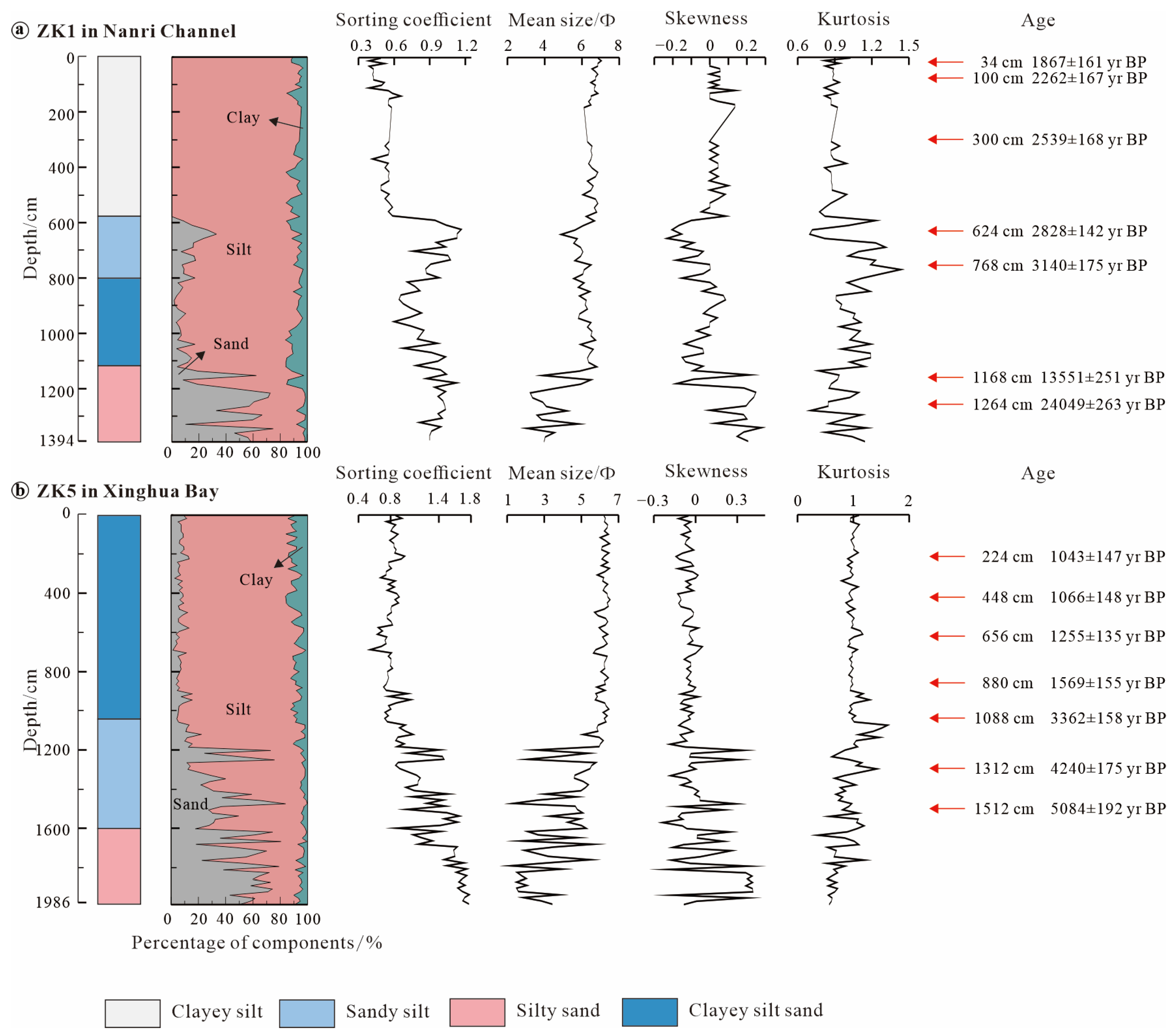
3.2.1. Granularity Analysis

The methodological steps of sample processing and testing were carried out in accordance with the requirements of the Code of Practice for Marine Bottom Sediment Survey by the 908 Special Project of the State Oceanic Administration of China, and the experiments were carried out at the Testing Company Limited of Shandong Bureau Group, China Metallurgical Geology Bureau. The samples were analyzed using a laser particle sizer (Mastersizer A3000) of Malvern Panalytical Ltd. from Malvern, UK, with a particle size range of 0.02~2000 μm and an error of <2% in repeated measurements. The results were calculated according to the Folk–Ward graphical formula, and four particle size parameters including mean size, sorting coefficient, skewness, and kurtosis were calculated and graded using the GRADISTAT 8.0 software.

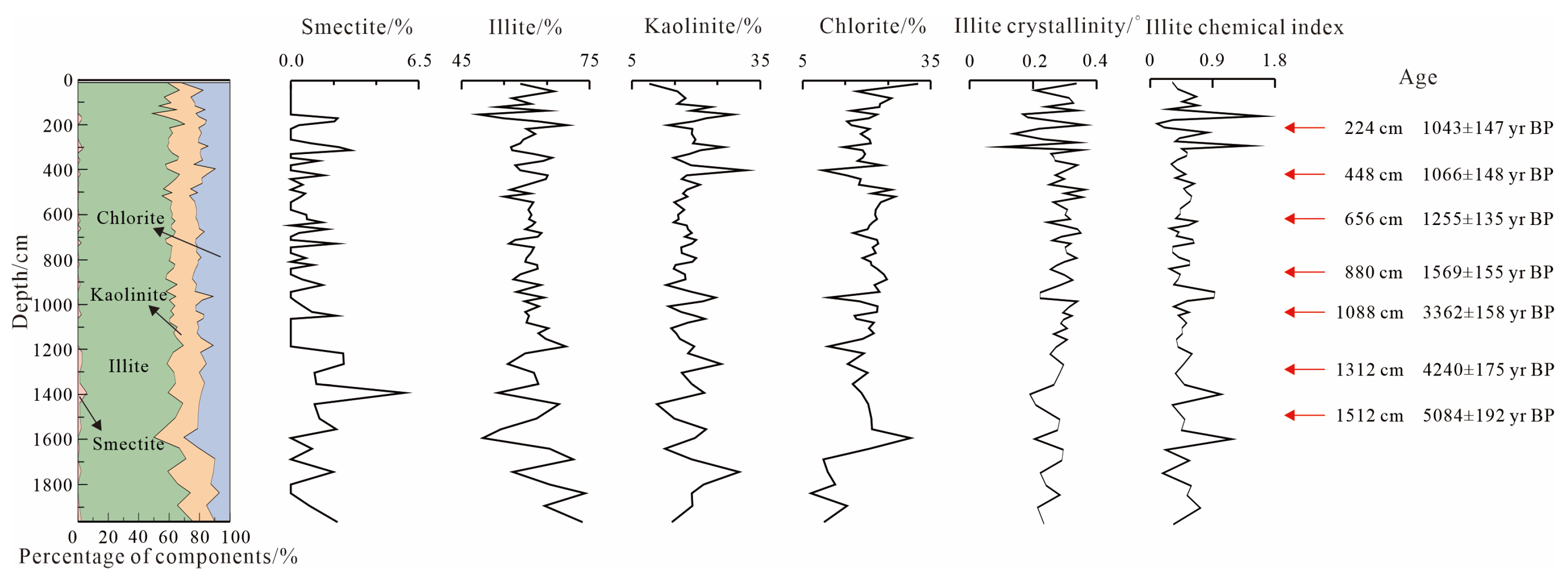
3.2.2. Clay Minerals Analysis

The pretreatment process of clay minerals was as follows: 10 g of the sample was weighed in a beaker, and 0.5% dilute hydrochloric acid was added to remove carbonate minerals. The samples were then washed with distilled water, and 10% hydrogen peroxide was added to remove organic matter [10]. Then, stirring and resting occurred until no bubbles were generated. The remaining sample was then washed clean using distilled water. Subsequently, 2000 mL of distilled water as well as a small amount of dispersant were added for sedimentation and sorting. According to the Stokes sedimentation formula, the suspension with particle size less than 2 μm was extracted. We added 10 mL of hydrochloric acid solution with a concentration of 1 mol·L−1 to make the sample flocculate and precipitate, centrifuge it, washed the acid to neutral, and then air dried it.
The extracted 2 μm clay mineral particles were made into natural samples (denoted as N), which were analyzed by XRD. Subsequently, the same oriented samples were saturated with ethylene glycol vapor at 55 °C for 7 h to obtain ethylene-glycol-saturated samples (denoted as EG), which were then analyzed by XRD. The treated EG samples were heated to 550 °C for 2 h to obtain heated samples (noted as H), which were cooled to room temperature and then subjected to XRD analysis. The XRD analyses were recorded at the Zijin School of Geology and Mining, Fuzhou University, with the instrumentation of Bruker D8 Advance X-ray diffractometer from Germany, with a Cu target, a tube pressure of 40 kV, a tube current of 30 mA, and a scanning range of 3~70°, with a step size of 0.02° and a scanning speed of 4° 2θ/min.
The analysis of clay minerals was conducted using MDI Jade 6.0 software to determine the positions and integral areas of typical diffraction peaks. Biscaye’s semi-quantitative method was employed to complete the calculation of clay mineral contents [11]. The total contents of the four clay minerals, namely, smectite, illite, kaolinite, and chlorite, were considered to be 100%. The 17 Å (001) diffraction peak was used for smectite, while the illite was identified using the 10 Å (001) diffraction peak, and 7 Å diffraction peak was used to identify the sum of kaolinite and chlorite, with the specific ratios of the two being determined by fitting the ratio of the peak areas of 3.58 Å to that of 3.53 Å.

3.2.3. Accelerator Mass Spectrometry (AMS) 14C Dating

In order to determine the age of the sediments in both cores, foraminiferal samples from the drill holes were 14C-dated. Foraminifera with a large sample size and individual surface area were placed in an HCl solution with a concentration of no more than 0.1 mol/L, with the objective of removing potential secondary carbonates that may have formed on the surface. Additionally, any loose debris was removed through the use of ultrasonic cleaning. For foraminifera with small individual surface, care should be taken to retain as much of the sample weight as possible while deionized water is sonicated for possible secondary carbonates. The samples were subsequently rinsed to neutral, dried at 110 °C for 12 to 24 h, and examined under a microscope to select the most suitable samples for testing. The AMS 14C dating was conducted at Minjiang University with the use of an accelerator mass spectrometer for analysis. The pretreated samples were incinerated and made into graphited targets, which were put into the accelerator mass spectrometry for testing. The 14C concentration of the samples was determined by comparing the simultaneously collected 14C, 13C, and 12C beams of each sample to the oxalic acid standard CO2 and foraminifera. All calculations were performed with reference to NIST oxalic acid SRM 4990B as the primary standard and corrected by isotopic fractionation [12].

3.2.4. Cluster Analysis

In order to gain a deeper comprehension of the alternations in sediment composition and provenance within the study area, cluster analysis was employed to group ZK1, ZK5 and potential provenances based on the similarity of clay mineral characteristics. With the content of kaolinite, smectite, illite and chlorite as parameters, cluster analysis was conducted by SPSS 27 software. Cluster analysis uses the Euclidean square distance system to connect groups in the systematic clustering method.

4. Analysis and Discussions

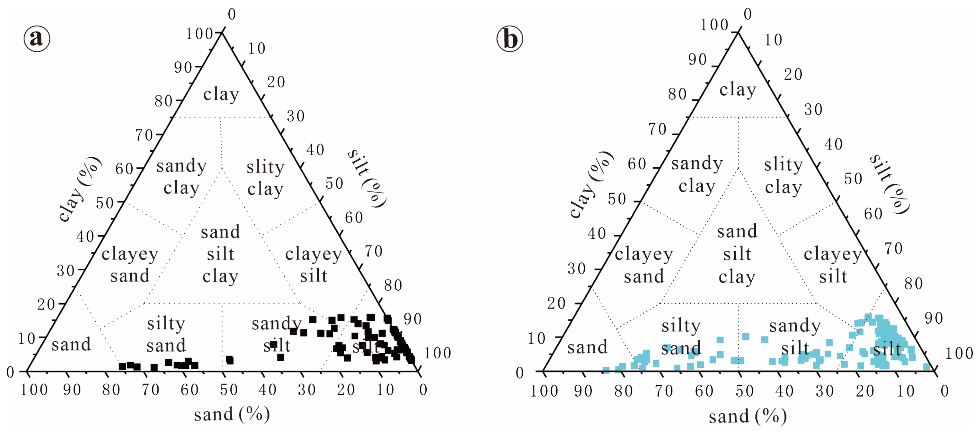
4.1. Granularity Analysis

The triangulation was made based on sand, silt, and clay fractions, as shown in Figure 2. The sediment types can be classified in to five categories: sand, silty sand, sandy silt, silt, and clayey silt. The samples were mainly concentrated in the sand-silt region with low clay mineral content.
As illustrated in Figure 2, the sediments in cores ZK1 and ZK5 were predominantly composed of silt. The content of silt in the sediments of cores ZK1 and ZK5 ranged from 24% to 97% and from 16% to 97%, respectively, with mean values of 79% and 70%, respectively. The content of sand in the sediments of cores ZK1 and ZK5 ranged from 0% to 74% and from 1% to 84%, respectively, with mean values of 13% and 23%, respectively. The content of clay ranged from 1% to 16% and from 1% to 16%, respectively, with mean values of 8% and 7%, respectively.
The lithology of cores ZK1 and ZK5 was highly variable, exhibiting some differences, as shown in Figure 3. The sediments in core ZK1 were classified as clayey silt, sandy silt, clayey silt sand, and silty sand, with the proportions varying from shallow to deep, respectively. S1-1 stage is dominated by dark gray clayey silt with a small amount of bioclastic debris (5%). The sorting coefficient ranged from 0.39 to 0.66, with an average value of 0.51. The sorting property was better, the average size fluctuated less, and the sedimentary environment was more stable, and combined with the sea level height in the period, it was assumed to be a littoral facies. S1-2 stage was dominated by dark gray sandy silt, with a small amount of bioclastic debris (10%), and the sorting coefficient ranged from 0.60 to 1.16, with an average value of 0.88. The sorting coefficient was medium, and the average size fluctuated less; the sedimentary environment was relatively stable, and the S1-2 stage was presumed to be a littoral facies by combining with other indices. The S1-3 stage was dominated by silty sand, with occasional bioclasts, and the sorting coefficients ranged from 0.82 to 1.12, with an average value of 0.97. The sorting was moderate, and the average grain size fluctuated widely, so the sedimentary environment was relatively unstable, and combined with the high sea level at this time, it is suggested that the S1-3 stage was a nearshore tidal flat facies.
The sediments in core ZK5 were clayey silt sand, sandy silt, and silty sand from shallow to deep, correspondingly. S5-1 stage and S5-2 stage were dominated by dark gray clayey silt with a small amount of bioclastic debris (5%), with sorting coefficients ranging from 0.55 to 1.08, with an average value of 0.81. The sorting was moderate, and the fluctuation of the average grain size was small, with the sedimentary environment being relatively stable, which is presumed to be a littoral facies in combination with the altitude of the sea level in this period. The S5-3 stage was dominated by dark gray-yellow silty sand, with gravel below 18.5 m. The sorting coefficient ranged from 0.86 to 1.78, with an average value of 1.40, and the sorting property was poor, with it being assumed to be a nearshore tidal flat facies in conjunction with the altitude of the sea level in this period.

4.2. Characterization of Clay Minerials

X-ray diffraction analysis showed that the clay minerals in the columnar sediments of Nanri Channel and Xinghua Bay were mainly illite, kaolinite, chlorite, and a small amount of smectite. The content of illite in ZK1 ranged from 32 to 77%, with an average value of 60%; the content of chlorite ranged from 8 to 31%, with an average value of 20%; the content of kaolinite ranged from 5 to 44%, with an average value of 19%; the content of smectite ranged from 0 to 3%, with an average value of 0.3%; the illite crystallinity ranged from 0.04 to 0.44°, with an average value of 0.22°; and the chemical index of illite ranged from 0.01 to 1.55, with an average value of 0.38 (Figure 4). In general, illite content showed a gradual decrease with depth, while kaolinite content showed a gradual increase with depth; chlorite content was relatively stable, and the trend of change with depth was not obvious. The overall trend of ilmenite crystallinity was similar to that of ilmenite content, and the chemical index of ilmenite was low and did not change much.
The content of illite in ZK5 ranged from 49 to 74%, with an average value of 61%; the content of kaolinite ranged from 9 to 32%, with an average value of 18%; the content of chlorite ranged from 8 to 31%, with an average value of 20%; the content of smectite ranged only from 0 to 6%, with an average value of 0.8%; the value of the crystallinity of illite ranged from 0.10 to 0.36°, with an average value of 0.28°; the chemical index of illite ranged from 0.01 to 1.60, with an average value of 0.51 (Figure 5). Generally speaking, the illite content showed a trend from more stable to gradually increasing with depth, the chlorite content showed a trend from more stable to gradually decreasing with depth, and the changes of kaolinite and chlorite content were not obvious with depth. The changes of illite crystallinity and illite chemical index were not obvious with depth.

4.3. Sedimentation and Dynamic Environment Analysis of Nanri Channel and Xinghua Bay

The grain size characteristics of sediments can effectively reflect their provenance and sedimentary environments [13]. According to the relationship between sedimentation and hydrodynamics proposed by Pejrup [14], the sedimentary hydrodynamic relationship of ZK1 and ZK5 columnar samples was made, as shown in Figure 6. In the hydrodynamic sedimentation relationship diagram, zones I, II, III, and IV indicate gradually increasing hydrodynamic conditions, and zones A, B, C, and D indicate sand content. Overall, the grain size of sediments in cores ZK1 and ZK5 gradually coarsened with depth.
Sediments in the S1-3 stage of core ZK1 were mainly in the B-IV zone, sediments in the S1-2 stage were mainly in the C-IV and D-IV zones, and sediments in the S1-1 stage were mainly in the D-IV zone. Therefore, the sand content in the nearshore tidal flat facies sediments in the S1-3 stage was high, with a coarse average grain size (4.34 Φ), which was in the medium value zone (4~6 Φ), and the sand content in the littoral facies sediments in the S1-2 stage and S1-1 stage was low, with a fine average grain size (6.35 Φ), which was in the high-value zone (6~8 Φ). Analysis of the results of the hydrodynamic environment and grain size analysis shows that the nearshore tidal flat facies sedimentary environment in the Nanri Channel since the Last Glacial Maximum to the present day had higher sand content, stronger average hydrodynamic perturbation control, and was overall under high-energy and unstable conditions, while the hydrodynamic perturbation control of the littoral facies was weaker, and the overall was under low-energy and stable conditions. Sediments in the S5-3 stage of core ZK5 were mainly in the B-IV zone, sediments in the S5-2 stage were mainly in the C-IV zone, and sediments in the S5-1 stage were mainly in the D-IV zone. Therefore, the sand content in the nearshore tidal flat facies in the S5-3 stage was high, with a coarser average grain size (2.86 Φ), which was in the low-value zone (0~4 Φ), while the sand content in the littoral facies in the S5-2 stage and S5-1 stage was low, with a finer average grain size (5.73 Φ), which was close to the high-value zone. The results show that the nearshore tidal flat facies sedimentary environment in Xinghua Bay has a high sand content, strong average hydrodynamic perturbation control, and overall high-energy and unstable conditions since the early-middle Holocene to the present, whereas the hydrodynamic perturbation control of the littoral facies was found to be weak, with overall low-energy and stable conditions.

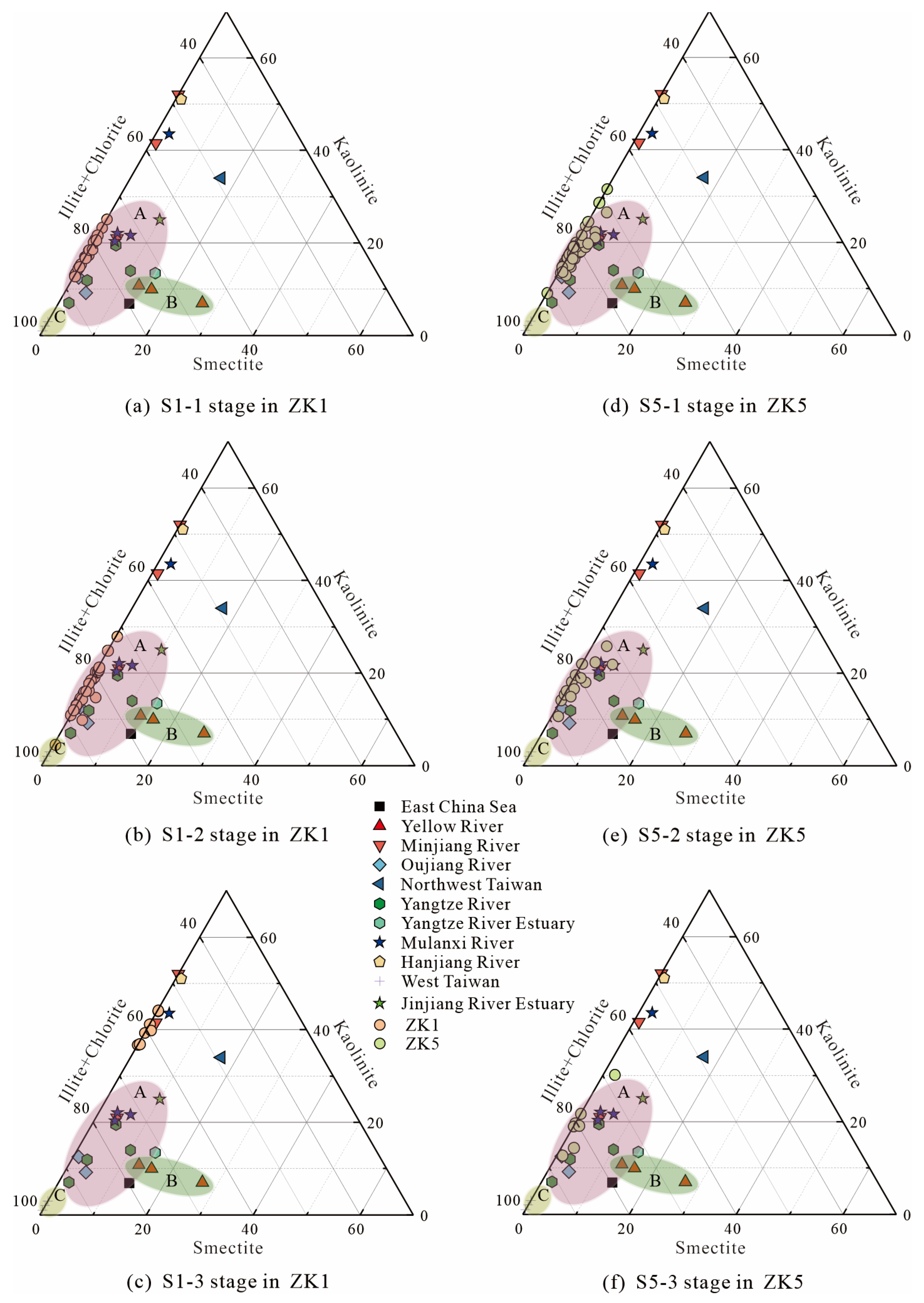
4.4. Provenance of Sediments in Nanri Channel and Xinghua Bay

The main sources of clay minerals in marine sediments are terrestrial detritus and marine authenticity, and the characteristics of clay mineral assemblages in sediments from different provenances are different. Therefore, clay minerals can be used as an excellent surrogate to indicate the source of the sediment [15]. The study area is located on the coast of Fujian, and the sedimentary facies is mainly littoral facies with weak hydrodynamic conditions, being mainly influenced by sediments from the mud wedge of the inner continental shelf of the East China Sea and fine-grained materials transported along the coast of Zhejiang and Fujian [6]. From the geographical location and potential source areas of the Nanri Channel and Xinghua Bay, the main source areas may be the Yangtze River, Oujiang River, Minjiang River, Mulanxi River, and Jinjiang River. Since the late Last Glacial Maximum, the mud wedge of the inner continental shelf of the East China Sea has essentially taken the Yangtze River and the rivers of Fujian and Zhejiang as the main input sources, with a relatively stable clay mineral content and a single assemblage type [16,17]. Therefore, in order to investigate the provenances of sediments in the Nanri Channel and Xinghua Bay, the potential source area and neighboring river sediments were compared with the clay mineral content in the present study area by making triangulation diagrams, as shown in Figure 7 [18,19,20,21,22,23,24,25,26,27,28,29,30,31,32,33]. As can be seen from Figure 7, the sediments can be mainly classified into three major categories according to the characteristics of clay mineral combinations, which were (A) Yangtze River-like sediments, (B) Yellow River-like sediments, and (C) Taiwan-like sediments. The Yangtze River-like sediments mainly cover the Yangtze River, Oujiang River, and Mulanxi River, etc. The clay minerals in the Yangtze River-like sediments were found to be mainly dominated by illite and chlorite (65~91%), followed by kaolinite (7~25%), and smectite as the least (2~15%); compared with the clay minerals of the Yangtze River-like sediments, the content of the clay minerals illite and chlorite in the Yellow River-like sediments was generally lower (54~63%), and the content of smectite was elevated (13~27%), with the content of kaolinite being the least (7~11%); the clay minerals of the Taiwan-like sediments contained a large amount of illite and chlorite (97~99%), and almost no kaolinite and smectite.
The S1-3 stage of core ZK1 in Nanri Channel corresponds to the Last Glacial Maximum to the early Holocene, and the clay mineral assemblage type of the S1-3 stage is quite different from that of the S1-1 and S1-2 stages, with a relatively low average content of illite (38%), an average content of kaolinite (40%) that is slightly higher than illite, an average content of chlorite (22%), and the lowest average content of smectite (1%), with the clay mineral assemblage type that is similar to that of the upper Mulanxi River alluvial deposits [28]. Combined with the coarser grain size, there is a higher proportion of sand in the sediments in the sedimentary stage, and the study area is completely exposed, considering that the sea level at that time was about 130 m lower than the present, and the relative sea level was still −23.55 m until the early Holocene [34,35,36]. Taken together, the provenance of the sediments in the S1-3 stage of core ZK1 was found to be dominated by in situ or adjacent granitic bedrock. The S1-2 stage corresponds to the early Holocene to late Holocene. The average content of illite in the sediments was 64%, while the average content of chlorite was 20%, the average content of kaolinite was 16%, and the average content of smectite was 1%. The content of clay minerals in the sediments of the S1-2 stage was markedly distinct from that of the S1-3 stage. This suggests that with the continuous rise of sea level, the provenance of the sediments in the Nanri Channel had undergone a significant change, and the influence of Yangtze River-like materials has become more pronounced. S1-1 stage, which corresponds to the late Holocene to the present time, has the most stable hydrodynamic environment and strong sorting properties. The combinations of clay minerals and their contents in the sediments are similar to those of the S1-2 stage, and the provenance of the sediment is dominated by the Yangtze River-like sediments. Consequently, alterations in the sedimentary environment may result in alterations in sediment supply, which, in turn, influences the grain size distribution characteristics of the sediments. The mode of sediment transport can be determined through the study of sediment grain size characteristics [37].
The S5-3 stage of core ZK5 in Xinghua Bay corresponds to the early-middle Holocene. The average content of illite in the columnar sediment samples was found to be 65%, while the average content of kaolinite was 20%. The average content of chlorite was 15%, and the lowest average content of smectite was 1%. As illustrated in Figure 6b, the hydrodynamic conditions in the S5-3 stage were more pronounced, and the sediment grain size was coarser and less sortable. This suggests that the clastic and clay minerals may not have been transported over long distances, and the provenance is mainly dominated by Mulanxi River, supplemented by the material of Yangtze River-like sediments. The S5-2 stage corresponds to the middle-late Holocene. The average content of the illite was the highest (62%), followed by chlorite (19%), kaolinite (18%), and smectite (1%). The grain size of the sediments in the S5-2 stage gradually decreased, indicating a weakening of hydrodynamic conditions and an intensification of the influence of the Yangtze River-like sediments. The S5-1 stage corresponds to the late Holocene, and the average content of the illite in the columnar sediments was the highest (61%), followed by chlorite (21%), kaolinite (18%), and smectite (1%). The grain size of the sediments in the S5-1 stage was finer, and the hydrodynamic conditions were stable, similar to the distribution range of the clay mineral content of the S1-1 and S1-2 stages of Nanri Channel in Figure 7, and it is comprehensively judged that the main provenance of sediment was Yangtze River-like sediments.
In order to further analyze and discuss the provenance of Nanri Channel and Xinghua Bay area, a cluster analysis was conducted on the clay mineral contents in the potential source area, ZK1 and ZK5 (Figure 8) [18,19,20,21,22,23,24,25,26,27,28,29,30,31,32,33]. It can be seen from the figure that it can mainly be divided into two types, one is the type mainly represented by the Yangtze River and Zhejiang–Fujian rivers (Type I), and the other is the type mainly represented by the Minjiang River (Type II). As indicated by I-1, the contents of S1-1, S1-2, S5-1, S5-2, and S5-3 stages in the study area were most similar to those in the Yangtze River and Oujiang River, followed by those in the Mulanxi River and Minjiang River. This suggests that the contents of the four clay minerals are comparable, indicating that the provenance in the study area is indeed predominantly influenced by the Yangtze River-like sediments. In Type II, it can be seen from II-1 that although the S1-3 stage in the study area is similar to the upstream of Mulanxi River and Minjiang River, the data of Minjiang River were still distributed in I-1 and II-2. Considering the sedimentary environment of S1-3 stage at that time, it is considered that the clay mineral contents of the S1-3 stage were most similar to the data of the upstream of Mulan River. In conclusion, the results of the analysis presented in Figure 8 are consistent with those of the previous sections. The provenances of the S1-1, S1-2, S5-1, S5-2, and S5-3 stages were mainly Yangtze River-like sediments, whereas the provenances of the S1-3 stage were completely different, mainly in situ or adjacent granite bedrock.

4.5. Paleoenvironmental Evolution

Clay minerals, as common provenance indicators, are better able to reflect the parent rock of the source area and the cold and warm cyclic climate change of the source area in terms of their combining characteristics, contents, and vertical changes [4]. The formation and transformation of clay minerals are primarily influenced by the climate environment [38]. Typically, kaolinite is formed in warm and humid climates from feldspar, mica, and pyroxene under acidic medium conditions, as well as strong weathering, and an increase in its content can be indicative of warm and humid climatic characteristics [39]. Smectite is the transformation of illite, muscovite, or other detrital minerals in the source or sedimentary areas and is mostly formed in warm and cool climatic environments under moderate weathering conditions [16]. Illite and chlorite are formed under similar conditions, as products of weak weathering conditions of the bedrock, and both serve as indicator minerals for cold and dry environments. However, since the content of clay minerals is a relative value, it is difficult to use changes in the content of individual clay minerals to directly indicate paleoenvironmental changes. In contrast, different combinations of clay minerals and their relative contents can effectively eliminate the dilution effect between clay minerals [40,41].
S1-3 stage of core ZK1 in Nanri Channel corresponds to the Last Glacial Maximum to the early Holocene; the sediment grain size was found to be the coarsest, the hydrodynamic conditions had strong disturbance control conditions, the sedimentary environment was unstable, and the content of various clay minerals varied greatly on the vertical scale. During the period to the end of the Last Glacial Maximum, illite content increased, kaolinite and smectite content decreased, and chlorite content changed less. From the above, there was a decrease in temperature during this stage. The S1-2 stage corresponds to the early Holocene to the late Holocene, experiencing the Holocene Optimum. One of the main reasons for the large difference in clay mineral content between S1-2 and S1-3 is that the source of the sediments in core ZK1 of the Nanri Channel had been changed by marine transgression, resulting in the predominance of Yangtze River-like sediments in the clay mineral source of the S1-2 stage. The clay minerals in the S1-2 stage were dominated by illite and chlorite on the vertical scale, and their contents varied little, with the average value of the illite chemical index being 0.48. Thus, it can be seen that the sediments in the S1-2 stage were indicative of a mild, dry, and weakly weathered environment in the source area. This is consistent with the warm and slightly dry paleoenvironment of this period, as indicated by pollen data [42]. The S1-1 stage corresponds to the late Holocene up to the present, and the clay mineral assemblages and contents in the section have not varied much, with a slight decrease in illite content and a slight increase in kaolinite content when compared with those in S1-2 stage, reflecting the generally mild and humid climate in this stage. This is consistent with the results of a previous study on environmental changes in the vicinity of the region [43].
The S5-3 stage of core ZK5 in Xinghua Bay corresponds to the early Holocene to Late Holocene, experiencing the Holocene Optimum. The composition of clay minerals in the S5-3 stage exhibited considerable variability at different vertical scales. This variability may be related to the occurrence of cold events at 8.2 ka BP and 6.2 ka BP, as indicated by previous studies [44]. However, the decrease in the illite percentage and the opposite percentage of kaolinite in this stage generally reflects a period of warm and humid climate. The S5-2 stage corresponds to the Middle and late Holocene, and the clay minerals in the vertical scale were found to be mainly illite and chlorite, and their contents tended to be stable, with an average value of illite chemical index of 0.49. The clay mineralogical characteristics of the sediments in the S5-2 stage indicate that the climate in this stage was generally mild and dry. The S5-1 stage corresponds to the late Holocene to the present, and the variation of clay mineral content in this stage is similar to that in the S1-1 stage of core ZK1 in the Nanri Channel, indicating that the climate in this stage is generally mild and humid. The paleoenvironment variation in the source area, as inferred from the content variation characteristics of the four clay minerals in the column sediments of ZK5, is roughly analogous to that observed in the column sediment S1-1 and S1-2 stages of ZK1, which can also confirm the rationality of the analysis of the paleoenvironment in the source area through the column sediment S1-1 and S1-2 stages of ZK1.

5. Conclusions

Particle size and XRD analysis of columnar sediments from two cores, ZK1 in Nanri Channel and ZK5 in Xinghua Bay, were conducted to investigate the changes in hydrodynamic conditions, provenance, and paleoenvironment evolution of Nanri Channel and Xinghua Bay since the Last Glacial Maximum. The age of formation of columnar sediments in the cores was determined by AMS14C, and the results revealed the following:
  • The grain size characteristics and the change rule of each clay mineral content in cores ZK1 and ZK5 indicated that core ZK1 can be divided into three stages. The S1-1 stage (0~578 cm), S1-2 stage (578~1138 cm), and S1-3 stage (1138~1394 cm) are distinguished by the corresponding sedimentary facies, namely, the littoral facies, littoral facies, and nearshore tidal flat facies, respectively. The core ZK5 is divided into three stages. The S5-1 stage (0~1058 cm), S5-2 stage (1058~1586 cm), and S5-3 stage (1586~1986 cm) are further subdivided into three sedimentary facies: the littoral facies, the littoral facies, and the nearshore tidal flat facies, respectively.
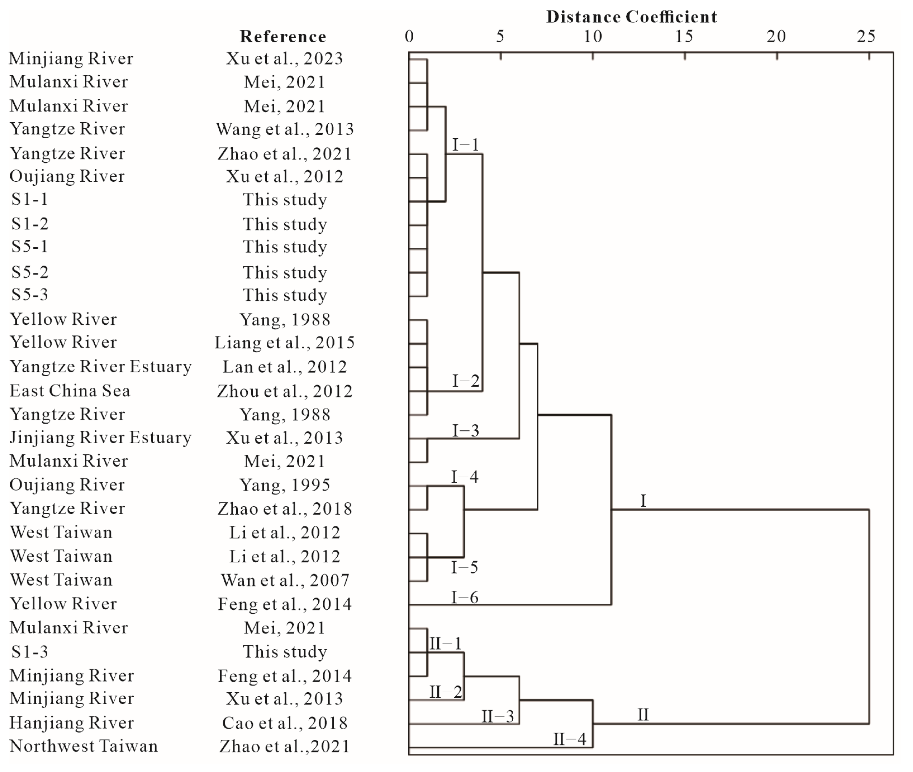
  • A comparison of the clay mineral assemblages and contents between the potential source area and the sediments in the study area suggests that the S1-1 and S1-2 stages of the sediments in core ZK1 are primarily influenced by Yangtze River-like sediments. And S1-3 stage is mainly affected by the neighboring rivers such as Mulanxi River and other rivers in the study area, with contributions from Yangtze River-like sediments. Moreover, the S5-1, S5-2, and 5-3 stages of the sediments in core ZK5 are predominantly influenced by Yangtze River-like sediments.
  • From the Last Glacial Maximum to the present, the sediments of core ZK1 in the Nanri Channel have undergone a climatic evolution characterized by cooler and wetter–mildly drier–mildly wetter; and from the early-middle Holocene to the present, the sediments of core ZK5 in Xinghua Bay have experienced a climatic transition of warmer and wetter–mildly drier–warmer and wetter.

Author Contributions

Conceptualization, J.W. and K.Y.; methodology, X.L., J.W. and K.Y.; software, X.L., Y.H., Y.W. and J.L.; formal analysis, X.L., Q.C., Y.H. and Y.W.; investigation, J.W. and Q.C.; resources, J.W.; data curation, Q.C., W.L. and J.L.; writing—original draft preparation, X.L.; writing—review and editing, X.L., J.W. and K.Y.; visualization, X.L., Y.H. and K.Y.; supervision, J.W. and Z.W.; project administration, J.W., W.L. and Z.W.; funding acquisition, J.W. All authors have read and agreed to the published version of the manuscript.

Funding

This research was funded by Scientific Research Project of China Metallurgical Geology Bureau (CMGBKY202204).

Institutional Review Board Statement

Not applicable.

Informed Consent Statement

Not applicable.

Data Availability Statement

The data presented in this study are available on request from the corresponding author.

Conflicts of Interest

The authors declare no conflicts of interest.

References

  1. Pang, H.; Lyu, S.; Chen, X.; Jin, A.; Loh, P.; Li, F.; Jiang, Y.; Yang, X.; Yan, K.; Lou, Z.; et al. Heavy Metal Distribution and Accumulation in the Spartina Alterniflora from the Andong Tidal Flat, Hangzhou Bay, China. Environ. Earth Sci. 2017, 76, 627.1–627.14. [Google Scholar] [CrossRef]
  2. Liu, J.; Cao, K.; Yin, P.; Gao, F.; Chen, X.; Zhang, Y.; Yu, Y. The Sources and Transport Patterns of Modern Sediments in Hangzhou Bay: Evidence from Clay Minerals. J. Ocean Univ. 2018, 17, 1352–1360. [Google Scholar] [CrossRef]
  3. Lan, X.; Zhang, X.; Liu, X.; Li, R.; Zhang, Z. Distribution Pattern of Clay Minerals in Surface Sediments of South Yellow Sea and Their Provenance. Mar. Geol. Quat. Geol. 2011, 31, 11–16. [Google Scholar] [CrossRef]
  4. Ma, C.; Chen, J.; Zhou, Y.; Wang, Z. Clay Minerals in the Major Chinese Coastal Estuaries and Their Provenance Implications. Front. Earth Sci. 2010, 4, 449–456. [Google Scholar] [CrossRef]
  5. Zhang, L. The Interannual Changes and Present Situation of Marine Environment in the Estuary of the Mulan River and the Qiulu River. J. Fish. Res. 2019, 41, 310–316. [Google Scholar] [CrossRef]
  6. Su, N.; Bi, L.; Guo, Y.; Yang, S. Rare Earth Element Compositions and Provenance Implications: A Case from Sediments of the Mulanxi River Estuary and Surrounding Sea Area. Mar. Geol. Quat. Geol. 2018, 38, 150–159. [Google Scholar] [CrossRef]
  7. Ji, L.; Liu, G.; Li, C.; Chen, Z.; Huang, Y. The Determination of Iodine in the Sediment Cores from the Intertidal Zone of the Xinhua Bay, the Jiulong Estuary and the Dongshan Bay. Acta Oceanol. Sin. Chin. Ed. 2013, 35, 177–183. [Google Scholar]
  8. Chen, Y.; Liu, Y.; Shu, F.; Cai, H.; Li, Y.; Chi, W.; He, J.; Chen, Z.; Zheng, B. Annual and Seasonal Variations of Current Fields Influenced by the Bay-island System on the Western Side of Taiwan Strait: A Case Study of Nanri Channel. J. Appl. Oceanogr. 2024, 43, 33–44. [Google Scholar]
  9. Liu, A.; Tang, J.; Zhang, J.; Wu, W. Seismic Stratigraphy and Buried Special Geomorphological Features in Shallow Strata off Middle and South Fujian, China. Mar. Geol. Quat. Geol. 2022, 42, 119–130. [Google Scholar] [CrossRef]
  10. Liu, Z.; Colin, C.; Huang, W.; Chen, Z.; Trentesaux, A.; Chen, J. Clay Minerals in Surface Sediments of the Pearl River Drainage Basin and Their Contribution to the South China Sea. Chin. Sci. Bull. 2007, 52, 1101–1111. [Google Scholar] [CrossRef]
  11. Biscaye, P. Mineralogy and Sedimentation of Recent Deep-Sea Clay in the Atlantic Ocean and Adjacent Seas and Oceans. Geol. Soc. Am. Bull. 1965, 76, 803–832. [Google Scholar] [CrossRef]
  12. Cherkinsky, A.; Culp, R.; Dvoracek, D.; Noakes, J. Status of the AMS Facility at the University of Georgia. Nucl. Instrum. Methods B 2010, 268, 867–870. [Google Scholar] [CrossRef]
  13. Ning, Z.; Zhang, Y.; Lin, X.; Bi, S.; Hu, G.; Kong, X. Weathering Characteristics and Provenance of the Surface Sediments in the Offshore of Northern Fujian. Mar. Geol. Front. 2020, 36, 12–21. [Google Scholar] [CrossRef]
  14. Pejrup, M. The Triangular Diagram Used for Classification of Estuarine Sediments: A New Approach. In Tide Influenced Sedimentary Environments and Facies; Boer, A., Gelder, V., Nio, S., Eds.; Reidel Publishing Company: Dordrecht, The Netherlands, 1988; pp. 289–300. [Google Scholar] [CrossRef]
  15. Chamley, H. Clay Sedimentology; Springer: Berlin/Heidelberg, Germany, 1989; pp. 21–50. [Google Scholar]
  16. Zhou, X.; Gao, S.; Jia, J. Preliminary Evaluation of the Stability of Changjiang Clay Minerals as Fingerprints for Material Source Tracing. Oceanol. Limnol. Sin. 2003, 34, 683–692. [Google Scholar]
  17. Ding, D.; Zhang, X.; Yu, J.; Wang, X. Area in Holocene Progress in Sedimentary Sources and Palaeoclimate Evolution in Zhejiang-Fujian Mud. J. Jilin Univ. Earth Sci. Ed. 2019, 49, 178–195. [Google Scholar] [CrossRef]
  18. Wang, Q.; Yang, S. Clay mineralogy indicates the Holocene monsoon climate in the Changjiang (Yangtze River) Catchment, China. Appl. Clay Sci. 2013, 74, 28–36. [Google Scholar] [CrossRef]
  19. Xu, Y.; Li, D.; Cheng, Y.; Li, Y. Provenance and Paleoenvironmental Evolution of Minjiang Subaqueous Delta Since the Middle-Late Holocene. J. Appl. Oceanogr. 2023, 42, 479–487. [Google Scholar]
  20. Zhou, X.; Li, A.; Wan, S.; Meng, Q. Clay Minerals in Surfacial Sediments of The East China Sea Shelf: Distribution and Provenance. Oceanol. Limnol. Sin. 2010, 41, 667–675. [Google Scholar]
  21. Li, C.; Shi, X.; Kao, S.; Chen, M.; Liu, Y.; Fang, X.; Lü, H.; Zou, J.; Liu, S.; Qiao, S.; et al. Clay Mineral Composition and Their Sources for the Fluvial Sediments of Taiwanese Rivers. Chin. Sci. Bull. 2012, 57, 676–684. [Google Scholar] [CrossRef]
  22. Yang, Z. Mineralogical Assembllages and Chemical Characteristics of Clays from Sediments of the Huanghe, Changjiang, Zhujiang Rivers and Their Relationship to the Climate Environment in Their Sediment Source Areas. Oceanol. Limnol. Sin. 1988, 19, 336–346. [Google Scholar]
  23. Feng, H.; Gao, A.; Zhu, X.; Wang, W.; Peng, J. Distribution Characteristic of Clay Minerals Contents in Minjiang River and Its Environmental Significance. J. Appl. Oceanogr. 2014, 33, 418–424. [Google Scholar]
  24. Yang, X. Clay Minerals of Suspended Sediments in Oujiang River. Mar. Sci. Bull. (Chin. Ed.) 1995, 14, 86–92. [Google Scholar]
  25. Zhao, D.; Sun, R.; Jiang, H.; Li, D. Sedimentary Characteristics and Paleoenvironmental Evolution of the Northwest Coast of the Taiwan Shoal Since Late Pleistocene. Mar. Geol. Quat. Geol. 2021, 41, 53–63. [Google Scholar] [CrossRef]
  26. Zhao, Y.; Zou, X.; Gao, J.; Wang, C.; Li, Y.; Yao, Y.; Zhao, W.; Xu, M. Clay Mineralogy and Source-to-sink Transport Processes of Changjiang River Sediments in the Estuarine and Inner Shelf Areas of the East China Sea. J. Asian Earth Sci. 2018, 152, 91–102. [Google Scholar] [CrossRef]
  27. Lan, X.; Zhang, Z.; Li, R.; Wang, Z.; Chen, X.; Tian, Z. Distribution of Clay Minerals in Surface Sediments Off Yangtze River Estuary. Mar. Sci. Bull. 2012, 14, 56–69. [Google Scholar]
  28. Mei, H. Clay Mineral Composition and Controlling Factors of the Zhe-Min Exorheic River Sediments and Their Implications for Sediment Source-to-Sink System Analysis. Master’s Thesis, Xiamen University, Xiamen, China, 2021. [Google Scholar]
  29. Cao, L.; Liu, J.; He, W.; Hafijur, R.K. Clay Mineral Assemblage Features of Major Rivers along the South China Coast and Their Contributions to the Northern South China Sea. Earth Sci. 2018, 43, 192–202. [Google Scholar]
  30. Wan, S.; Li, A.; Clift, P.; Stuut, J.W. Development of the East Asian monsoon: Mineralogical and sedimentologic records in the northern South China Sea since 20 Ma. Palaeogeogr. Palaeoclimatol. Palaeoecol. 2007, 254, 561–582. [Google Scholar] [CrossRef]
  31. Xu, Y.; Chen, J.; Wang, A.; Li, H.; Wang, W.; Zhang, X.; Lai, Z. Clay Minerals in Surface Sediments of the Taiwan Strait and Their Provenance. Acta Sedimentol. Sin. 2013, 31, 120–129. [Google Scholar]
  32. Xu, K.; Li, A.; Liu, J.; Milliman, J.; Yang, Z.; Liu, C.; Kao, S.; Wan, S.; Xu, F. Provenance, Structure, and Formation of the Mud Wedge along Inner Continental Shelf of the East China Sea: A Synthesis of the Yangtze Dispersal System. Mar. Geol. 2012, 291, 176–191. [Google Scholar] [CrossRef]
  33. Liang, X.; Yang, S.; Yin, P.; Zhao, Y. Distribution of Clay Mineral Assemblages in the Rivers Entering Yellowsea and East China Sea and the Muddy Shelve Deposits and Control Factors. Mar. Geol. Quat. Geol. 2015, 35, 1–15. [Google Scholar]
  34. Wang, S.; Wen, X. Last Glacial Maximum. Clim. Chang. Res. 2011, 7, 381–382. [Google Scholar]
  35. Cai, B. The Evidence of Dry Land of the Taiwan Straits During Late Wurm Glaciation. Mar. Sci. 2002, 26, 51–54. [Google Scholar]
  36. Wang, L.; Wang, Z.; Li, C. Holocene Relative Sea-level Change of Fujian Coast, Southeastern China: Geological Records and Comparison with Glacio-hydro Isostatic Adjustment Modelling. Acta Oceanol. Sin. Chin. Ed. 2022, 44, 109–123. [Google Scholar]
  37. Feng, Q.; Fan, D.; Wang, K.; Jia, X.; Chen, Q. Provenance and sedimentary evolution of the Southwest Arabian Sea since 45 ka. Acta Oceanol. Sin. Chin. Ed. 2023, 45, 56–69. [Google Scholar]
  38. Liu, R.; Mei, X.; Zhang, J.; Zhao, D. Characteristics of Clay Minerals in Sediments of Hemudu Area, Zhejiang, China in Holocene and Their Environmental Significance. China Geol. 2019, 2, 8–15. [Google Scholar] [CrossRef]
  39. Zhang, X.; Zheng, M. X-ray Powder Diffraction of Clay Minerals of SZK01 Core of Zabuye Lake, Tibetan Plateau. Spectrosc. Spectr. Anal. 2014, 34, 3119–3122. [Google Scholar]
  40. Wan, S.; Yu, Z.; Clift, P.; Sun, H.; Li, A.; Li, T. History of Asian Eolian Input to the West Philippine Sea over the Last One Million Years. Palaeogeogr. Palaeoclimatol. Palaeoecol. 2012, 326, 152–159. [Google Scholar] [CrossRef]
  41. Yu, Z.; Wan, S.; Colin, C.; Yan, H.; Bonneau, L.; Liu, Z.; Song, L.; Sun, H.; Xu, Z.; Jiang, X. Co-evolution of Monsoonal Precipitation in East Asia and the Tropical Pacific ENSO System since 2.36 Ma: New Insights from High-resolution Clay Mineral Records in the West Philippine Sea. Earth Planet. Sci. Lett. 2016, 446, 45–55. [Google Scholar] [CrossRef]
  42. Wang, K.; Lu, J.; Zheng, Y. Late Quaternary Pollen-Diatom Assemblages along Fujian Seashore and Their Paleoenvironmental Implications. Acta Micropalaeontol. Sin. 1995, 12, 388–397. [Google Scholar]
  43. He, Y. The Sedimentary Sporopollen and Microbody Paleontology and Its Paleoenvironment Significance of the Late Quaternary Period Basin in Quanzhou City, Fujian Province. Geol. Fujian 2011, 30, 224–232. [Google Scholar]
  44. Wang, J.; Bai, W.; Wang, Z.; Wang, M.; Li, B. The Holocene climatic evolution in Eastern China and its bearing on climatic events. Mar. Geol. Quat. Geol. 2022, 42, 167–177. [Google Scholar] [CrossRef]
Figure 1. (a) Geographic map of the study area, showing the Taiwan warm current and Zhejiang and Fujian coastal current. (b) Column sample location map. Dark blue dots denote the core location. Map drawn with Ocean Data View.
Jmse 12 01270 g001
Figure 2. Triangulation of ZK1 and ZK5 sediment grain size classification. (a) ZK1, the black squares; (b) ZK5, the blue squares.
Jmse 12 01270 g002
Figure 3. Grain size characteristics of columnar sediments in Nanri Channel and Xinghua Bay. (a) ZK1 in Nanri Channel; (b) ZK5 in Xinghua Bay. The red arrow represents the age of the sediments at the depth in column sample.
Jmse 12 01270 g003
Figure 4. Characterization of the variation of the content of ZK1 clay minerals. The red arrow represents the age of the sediments at the depth in column sample.
Jmse 12 01270 g004
Figure 5. Characterization of the variation of the content of ZK5 clay minerals. The red arrow represents the age of the sediments at the depth in column sample.
Jmse 12 01270 g005
Figure 6. Hydrodynamic and sedimentation relationship of ZK1 and ZK5.
Jmse 12 01270 g006
Figure 7. Comparison of clay mineral fractions of sediments in the study area from each potential source area. (A): Yangtze River-like sediments; (B): Yellow River-like sediments; (C): Taiwan-like sediments.
Jmse 12 01270 g007
Figure 8. Cluster analysis diagram of clay mineral fractions of sediments in the study area from each potential source area [18,19,20,21,22,23,24,25,26,27,28,29,30,31,32,33].
Jmse 12 01270 g008
Table 1. Latitude, longitude, and submerged orifice elevation of column sample locations.
Column Sample NumberLatitudeLongitudeSubmerged Orifice Elevation (m)Column Sample Length (m)
ZK125°13′43″ N119°23′45″ E−18.2413.94
ZK525°22′43″ N119°23′17″ E−15.9919.86
Disclaimer/Publisher’s Note: The statements, opinions and data contained in all publications are solely those of the individual author(s) and contributor(s) and not of MDPI and/or the editor(s). MDPI and/or the editor(s) disclaim responsibility for any injury to people or property resulting from any ideas, methods, instructions or products referred to in the content.

