Abstract
This paper presents a localization method for an underwater multitonal source by using a vertically distributed system in deep water. The system is composed of two kinds of nodes. One is a node at large depth, and the other is a node covering most of the water column. The former and latter are utilized to estimate the source range and depth, respectively. Specifically, the proposed method estimates the source range by matching the spatial arrival angle measured by the first kind of node with the replicas calculated by the acoustic model. Based on the estimation value of the source range, the second kind of node is utilized to estimate the source depth by using an incoherent time reversal method. The effectiveness of the proposed method is demonstrated through numerical simulations. The effects of the measurement error and the sound speed profile mismatch on the performance of the proposed method are also analyzed.
1. Introduction
The ocean contains rich natural resources such as oil and gas. Exploring and utilizing those abundant untapped natural resources is necessary to develop advanced technologies and equipment for underwater navigation, localization, and communication [1,2]. Therefore, source localization techniques have been extensively investigated over the years. In deep water, a well-known acoustic propagation waveguide is the so-called reliable acoustic path (RAP), which refers to the direct (D) and possibly the surface-reflected (SR) paths between a shallow source and a deep receiver. The physical characteristics and their application of RAP have been widely studied in recent years [3,4,5]. Among various studies on RAP, passive source localization with a vertical line array (VLA) is of continuing interest and concern to many researchers.
Under an RAP environment, the interference characteristic between D and SR paths will cause the periodical fluctuation of the received acoustic intensity. On basis of this feature, Zurk et al. [6] achieved the source depth estimation by exploiting the spatial structure resulting from the coherent addition of the D and SR paths. Kniffin et al. [7] further analyzed the performance of the method and clarified the application limitation of the method. For a broadband source with unknown spectrum, Cao et al. [8] introduced the concept of Riemannian distance to improve the performance of the traditional matched field processing (MFP) method and located a broadband sound source based on a short aperture VLA. Depth estimation also can be achieved by interference matching [9], Fourier transforming [10], striation tracking [11], deep neural network training [12,13], beam intensity resampling [14], etc. For the line spectrum or narrowband sources, source depth can be estimated by using a modified Fourier transform method [15,16]. Simultaneously, the source range also can be estimated by matching the arrival angle of the D and SR paths with the replicas calculated via the acoustic model [10,17].
However, there are some defects for single node localization methods. Under an RAP environment, it is challenging to achieve robust source localization for a stationary multitonal source by using only a short-aperture VLA deployed near the sea bottom. Therefore, resorting to the target motion information becomes imperative. Xu et al. [18] utilized the acoustic field oscillation at different frequency points, which is caused by the interference between the D and SR paths, to estimate the multitonal source motion parameters, including the initial range, velocity, and depth. Qi et al. [19] utilized the depth-dependent modulation in the arrival angle domain caused by the interference between the D and SR acoustic arrivals to achieve the passive source depth estimation for a moving tonal source. One can find that the existing localization methods for a line spectrum source are mainly based on the arrival angle domain interference structure or multipath arrival angles, for which the target is usually assumed to be a moving source. For those scenes, source motion information is of the essence. But in practical scenarios, the underwater acoustic source may keep stationary for a short period of time. Consequently, these methods will fail.
In order to address the above-mentioned question, additional asynchronous hydrophone nodes are considered for deployment above the synchronous short-aperture VLA to construct a vertically distributed system. The system is a vital complement to address the limitation. The application of distributed systems in deep water has been developed in recent years. For the large-scale distributed systems, the current research can be broadly divided into two categories. The first one uses the parameter measurement values (such as angle, time-delay, etc.) observed by the distributed systems to realize the source localization [20,21,22,23]. By integrating environmental information into the process of a target localization model, the localization error caused by the mismatch of the plane wave model can be effectively eliminated. Another way to achieve the source localization is by taking advantage of the spatial distribution characteristics of an underwater acoustic field. Gebbie el. al. [24] utilized the propagation delay of D and SR paths observed by different large depth sensors to construct a cost function and realize the three-dimensional positioning of whales. Xu et al. [25] investigated three-dimensional source localization based on the time delays between the D and SR paths measured by using asynchronous distributed sensors. The literature [26] proposed a matched-filed source localization method based on multiple distributed vertical arrays. Subsequently, Tollefsen et al. [27,28] verified the advantages of the distributed system by comparing it with a single line array. The study further pointed out that a distributed system incorporating both horizontal and vertical arrays demonstrates superior performance in the MFP localization method compared with the system comprising only horizontal or vertical arrays.
In this paper, we focus on a scenario where a stationary multitonal source, whose spectrum consists of several tonal components, is observed by a vertically distributed system in deep water. The system is composed of two kinds of nodes. One is a node at large depth, and the other is a node covering most of the water column. Specifically, the source range is estimated by matching the spatial arrival angle of D and SR paths obtained via the first kind of node with the replicas calculated by the acoustic model. Based on the estimated source range results, the second kind of node is utilized to estimate the source depth by an incoherent time reversal method. Numerical simulations are conducted in a typical deep-water environment to analyze the performance of the proposed method. The results show that the proposed method can effectively achieve the source range and depth estimation in most cases. However, the performance of the proposed method will seriously deteriorate due to the excessive source range or the unreasonable hydrophone spacing arranged in the second node of the vertically distributed system.
The rest of this paper is organized as follows. Section 2 formulates the application scene in this paper. The principle of the proposed method and its operation procedure are detailed in Section 3. In Section 4, the effectiveness of the proposed method is verified by using the numerical simulation. The performance of the proposed method is analyzed in Section 5, which is followed by a concluding remark in Section 6.
2. Application Scene
A typical application scene is illustrated in Figure 1. The localization system consists of two kinds of nodes. The first one is a node at large depth, and the other is a node covering most of the water column. The target is a stationary multitonal source. When the receiver is deployed at large depth and the submerged source is near the sea surface, the main sound propagation paths are the D and the SR paths, which are indicated by red and blue lines, respectively, in Figure 1. Under this environment, the D and SR paths are dominant and robust, making them available for source localization. In this paper, a bottom-moored short-aperture synchronous VLA is used as the first kind of node, which is responsible for the estimation of source range. The second kind of node is composed of several non-synchronous self-contained hydrophones, which are distributed vertically. They are responsible for the estimation of the source depth based on the estimated result of the source range. The layout depth of the first kind of node is denoted as zr,1. The depth of hydrophones in the second kind of node is denoted as zr,2, zr,3, …, zr,N, respectively. The sound source signal is composed of L single frequency signals. Under the above background, the passive localization method of a multitonal source will be studied, aiming to achieve the estimation of source range rs and depth zs by using the acoustic field characteristic information obtained from the vertically distributed system.

Figure 1.
Application scene.
3. Localization Method
In order to solve the problem of source localization in Figure 1, a joint localization method by using spatial matching for range estimation and incoherent time reversal for depth estimation is proposed in this section. Specifically, the source range is estimated by matching the spatial arrival angle of the D and SR paths obtained by the first kind of node with the replicas calculated by the acoustic model. Based on the estimated source range result, the second kind of node is used to estimate the source depth through an incoherent time reversal method. The process of the proposed method is described in detail below.
3.1. Range Estimation
Under an RAP environment, the D and SR paths play a dominant role in the acoustic field. Therefore, the acoustic field arrival structure at large depth is relatively simple. However, the arrival angles of the D and SR paths are so close that the conventional DOA estimation method cannot distinguish them accurately. For the D and SR paths, the node deployed at a large depth usually can only give one arrival angle information. Herein, it is referred to as the DSR group arrival angle, which is denoted as θDSR. Due to the similarity of the amplitudes between the D and SR paths, θDSR is roughly equal to the average value of the arrival angles of the D and SR paths.
θDSR is approximately independent of the source depth but very sensitive to the source range. Thus, the source range can be estimated by matching the estimated θDSR with the value calculated by the acoustic model. The cost function for source range estimation is expressed as
where indicates the estimated result of the DSR group arrival angle by the first kind of node, and indicates the value of the DSR group arrival angle calculated by the acoustic model at the range of r. The peak position of the cost function is the estimated result of the source range.
where indicates the range corresponding to the maximum value of the cost function.
For a given source range of r, can be calculated by the following function.
where Meanz indicates the average operation for variable z, and indicates the DSR group arrival angle calculated by the acoustic model at the range of r and depth of z. zs-max indicates the maximum possible depth of the source.
When beamforming is utilized as the method of DOA estimation, can be obtained through the following function.
where P(θ) indicates the average value of the beam output power on L frequency points.
where w(fl, θ) indicates that the weight vector corresponds to the angle θ at the frequency fl. R(fl) indicates the covariance matrix of the received signals at the frequency fl. The superscript H denotes the conjugate transpose of a vector.
It is worth noting that can be obtained through various DOA estimation methods, such as beamforming methods, subspace methods and sparse reconstruction methods, etc. If a single vector hydrophone is utilized as the receiving node at large depth, can be estimated through the ratio between the vertical and horizontal energy fluxes. Therefore, in order to better focus on the source localization, the estimation process of will be weakened in the following section. In the subsequent simulation analysis, we directly use a theoretical θDSR value calculated by the acoustic model with a Gaussian white noise as the measurement value.
3.2. Depth Estimation
The source depth is estimated by using an incoherent time reversal method. Specifically, the proposed method is based on both the reciprocity theorem and the assumption of the time-invariant property of the acoustic field. The amplitude information of the received signal is used, while the phase information is discarded. Thus, the acoustic field can be modeled and calculated without prior information of the source. The method can be regarded as the application of the incoherent time reversal method in a deep water environment. The principle of the method can be briefly described as follows.
At the given range, a near-surface source will generate a number of coherent beams, covering the areas with the strongest acoustic energy. The trajectories and grazing angles of these coherent beams are related to the source depth. Thus, the estimation of the source depth can be achieved by searching the location with the strongest energy at the given range. Overall, the execution steps of the proposed method are as follows.
- (1)
- N hydrophones are set at different depths zj (j = 2, 3, …, N). The sound source transmitted the signal at the range of r. The acoustic intensity received by the hydrophone at each receiving depth is denoted as Ij;
- (2)
- The sound intensity Ij values received by each hydrophone are sorted in descending order. The largest K values are selected, and the depth of the corresponding hydrophone zk (k = 1, 2, …, K) is kept. K is the number of simulated sound sources used for time reversal;
- (3)
- Establishing the acoustic field model and the sound source are set at K depths, i.e., zk (k = 1, 2, …, K). The transmission loss distribution versus depth is calculated by the model at the horizontal range r. The transmission loss at depth d and frequency point fl is denoted as TLk(fl,d);
- (4)
- Adding the transmission loss results TLk(fl,d) calculated at K source depths in step (3) to obtain the incoherent time reversal result as follows:
- (5)
- Performing the above operations at L frequency points and the incoherent time reversal results at all frequency points are averaged. The cost function of source depth estimation is constructed as
Finally, the estimated result of source depth can be expressed as
The transmission loss in the above steps can be replaced by the corresponding sound energy. If so, Equation (6) should be an ordinary algebraic superposition. The peak valley position of the final cost function indicates the candidate source depth. The complete localization flow of the proposed method is shown in Table 1

Table 1.
The flow of the proposed source localization method.
As a summary, this method is mainly based on the coherent phenomenon implied in the received acoustic field. Therefore, the second kind of node should be deployed as much as possible in the depth below 2000 m to better observe the needed coherent phenomenon for the source near the sea surface. In essence, the proposed method in this section transforms the spatial information to the frequency domain information of the acoustic field.
4. Numerical Simulation
In this section, numerical simulations are conducted to verify the effectiveness of the proposed method. The simulation environment is illustrated in Figure 2a. The SSP is a typical Munk profile [29].
where c(z) indicates the sound speed at depth z, zDSC = 1100 m, cDSC = 1500 m/s, ε = 0.00737. η indicates the dimensionless depth relative to zDSC. The depth of the surface waveguide is 90 m, in which the speed of sound increases linearly from 1537 to 1538 m/s. The water depth is 6000 m. The sea surface and bottom are modeled as a flat pressure-release boundary and soft half-space, respectively. The density, sound speed and attenuation coefficient of the sea bottom are ρb = 1.6 g/cm3, cb = 1600 m/s, αb = 0.14 dB/λ, respectively. The well-developed Bellhop acoustic toolbox is used to as the acoustic simulation model [30]. Figure 2b shows the distribution of acoustic transmission loss calculated by the Bellhop model by using the simulation conditions shown in Figure 2a.
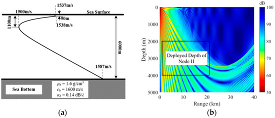
Figure 2.
(a) A typical SSP used in simulation. (b) Distribution of the acoustic transmission loss (the source depth is 100 m).
In the simulation, a short-aperture synchronous VLA is deployed near the sea bottom as the first kind of node. The receiver depth at the midpoint of the VLA is 4700 m. The VLA consists of 16 hydrophones spaced 4 m apart. The second kind of node is composed of 101 non-synchronous self-contained hydrophones, which are regularly deployed at the depth of 2000–4000 m. The depth interval is 20 m. The whole hydrophones are assumed to be ideal, which provide a flat frequency response over the operating frequency range and are omnidirectional. A source is assumed to be deployed at depth of 150 m, and the horizontal distance between the source and the vertically distributed system is 9 km. The source signal is composed of three single frequency components (f1 = 100 Hz, f2 = 150 Hz, and f3 = 200 Hz). The sound energy distribution received by the second kind of node is shown in Figure 3. One can find that the received sound intensity at different frequency points fluctuates along the receiver depth obviously.
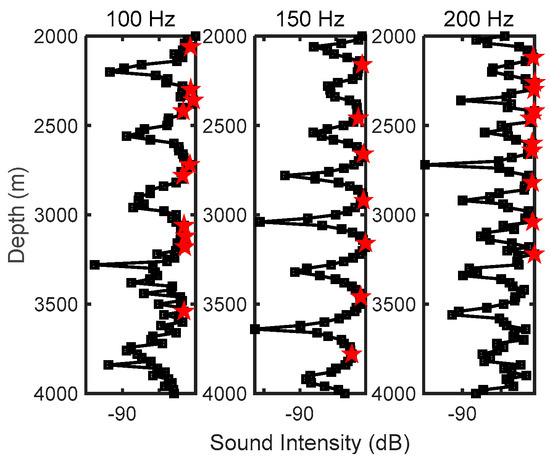
Figure 3.
The sound energy distribution received by the second kind of node. The red pentagrams indicate the assumed depth of the virtual source for the process of source depth estimation.
Firstly, the effectiveness of the proposed method is verified under an ideal condition (considering that is equal to the ideal value, and the received acoustic field has no noise). The scanning grid accuracy is 0.019 km in range and 1 m in depth. The maximum source depth is set as zmax = 300 m, and the value of the parameter K in the source depth estimation process is selected as follows:
where Nump indicates the number of local peaks in the sequence of sound intensity received by the second kind of node. K cannot be too small or too large. If K is too large, some depths that are redundant are selected to model the acoustic field, which would result in the increase in the computation amount. Adversely, a minimum K will also cause a wrong source depth.
The localization results are illustrated in Figure 4. The left and right panels present the estimated result of the source range based on Equation (2) and the estimated result of source depth based on Equation (8), respectively. The black line in the panels indicates the estimated results, and the red line indicates the true position of the source. The estimated source range is 9.01 km with an error of 0.07%. The estimated source depth is 149 m with an error of 0.7%. As a result, the simulation result under this typical environment has well verified the effectiveness of the proposed method.
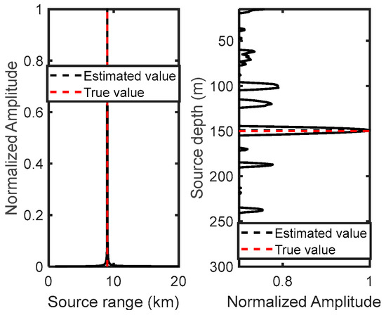
Figure 4.
Localization results under an ideal environment. The (left) and (right) panels illustrate the range and depth estimation results, respectively.
In addition, the proposed method only requires grid scanning in the range dimension (at the process of source depth estimation, the grid division is used for the acoustic field calculation and not for the source depth estimation). Due to the low complexity of the cost function, the computation speed of the proposed method is relatively fast. Actually, the main computational burden of the proposed method lies in the replica field computation. The drawbacks of the proposed method are also obvious. The proposed method requires additional hydrophones and needs more environmental information (such as the SSP and the sea bottom information) to accurately model the acoustic field.
5. Performance Analysis
The performance of the proposed method is sensitive to many aspects, such as the ocean environment, parameter measurement error, the source position, etc. This section discusses the effect of SSP, measurement error of θDSR and the source depth on the performance of the proposed method. The detailed analysis is as follows.
5.1. Effect of the SSP
The performance of the proposed method relies on the modeling results of the acoustic field. Thus, it is necessary to analyze the robustness of the proposed method to the SSP mismatch. For this purpose, two mismatched SSPs are constructed. The results are shown in Figure 5. The SSP indicated by the black line is the same as the SSP in Figure 2, which is used for the calculation of the measurement filed. The blue line and the red line are the mismatched SSPs, which are used to model the replica field. They are called M-SSP1 and M-SSP2, respectively. In comparison with the SSP in Figure 2, M-SSP1 only has a sound speed mismatch within the isothermal layer near the sea surface, while M-SSP2 has a mismatch throughout the full depth.
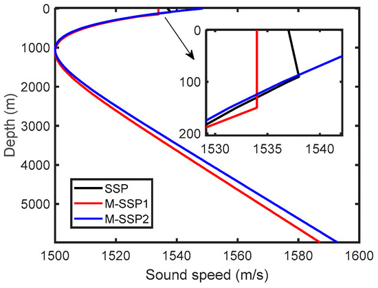
Figure 5.
The SSP used in numerical analysis.
The standard deviation of the angle estimation error σ is set to be 0.5°. The other simulation conditions are the same as shown in Figure 2. The source localization results with different mismatched SSPs are shown in Figure 6. The upper and lower rows correspond to M-SSP1 and M-SSP2, respectively. The left and right columns present the source range and depth estimation results, respectively. One can find that the proposed method is very sensitive to the SSP mismatch. Even if the SSP mismatch occurs near the sea surface, the source depth estimation results of the method are also affected seriously. Furthermore, the impact of SSP mismatch will be more significant as the source range increases. For M-SSP1 and M-SSP2, the range boundary at which that the source depth can be estimated accurately is 15 km and 10 km, respectively. In addition, one can see that the SSP mismatch has a greater impact on source depth estimation than range estimation.
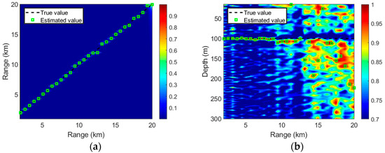
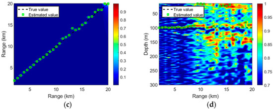
Figure 6.
Effect of SSP mismatch on the performance of the proposed method. (a,c) are source range estimation results by using M-SSP1 and M-SSP2, respectively. (b,d) are source depth estimation results by using M-SSP1 and M-SSP2, respectively.
5.2. Effect of the Measurement Error of θDSR
The effects of the measurement error of θDSR on the localization performance of the proposed method are investigated. The measurement error is referred to as noise in this paper for the sake of convenience. In order to better focus on the multitonal source localization, the ideal θDSR value with a zero-mean Gaussian white noise is considered as the measurement value in this section. The noise standard deviation is σ. The source depth is set to be 100 m. The other simulation conditions are the same as above. For each value of σ, the proposed method is utilized to locate the source with the source range varying from 1 to 20 km.
The source localization results are shown in Figure 7, where the left and right columns present the source range and source depth estimation results, respectively. Different rows correspond to different noise standard deviations (from top to bottom: σ = 0°, σ = 0.1°, σ = 0.5° and σ = 1°). As can be seen, when the noise standard is within 0.1°, the simulation results are good, and the precise localization results are achieved at almost the entire source range. With the increase in the noise level, the accuracy of source range and depth estimation will simultaneously decrease. For the current transceiver configuration, if the source range exceeds 15 km, the depth estimation error will increase and the estimation accuracy will decrease significantly when σ = 1°. In fact, the estimated result of the source depth is dependent on the accuracy of the source range estimation. For a specified noise level, the proposed method has poorer performance in range and depth estimation as the source range increases. When the source range increases, the path length of the sound propagation also increases, resulting in a larger range estimation error. The error in source range estimation further causes a worse estimation accuracy of the source depth.
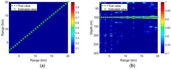
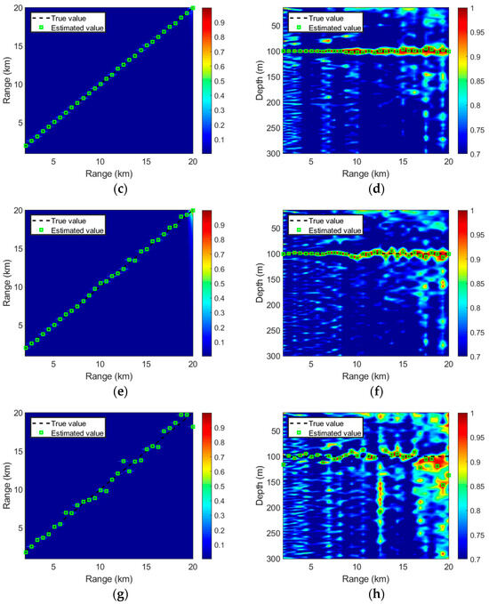
Figure 7.
Effects of θDSR error on the localization performance of the proposed method. The left (a,c,e,g) and right (b,d,f,h) columns present the estimation results of source range and depth, respectively. Different rows correspond to different noise standard deviation (from top to bottom: σ = 0° (a,b), σ = 0.1° (c,d), σ = 0.5° (e,f) and σ = 1° (g,h)).
5.3. Effect of the Source Depth
The sensitivity of source depth to the localization performance of the proposed method is also analyzed. The noise standard deviation is set to be 0.5°. Other simulation conditions are the same as above. The localization results are shown in Figure 8, where the left and right columns present the source range and depth estimation results, respectively. Different rows correspond to different source depth (from top to bottom: 50 m, 100 m, 150 m and 200 m).
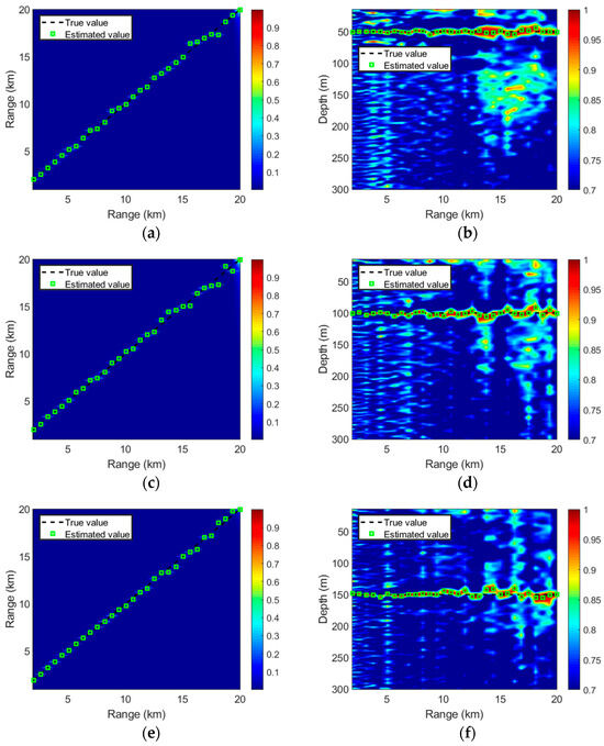
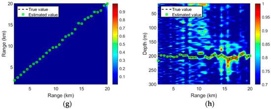
Figure 8.
Effect of source depth on the performance of the proposed method. The left (a,c,e,g) and right (b,d,f,h) columns present the estimation results of source range and depth, respectively. Different rows correspond to different source depth (from top to bottom: 50 m (a,b), 100 m (c,d), 150 m (e,f) and 200 m (g,h)).
As can be seen, the proposed method works well at these four typical depths. The range estimated error under different source depths is within 1 km. However, the depth estimation accuracy of the proposed method decreases as the source range increases. By contrasting the depth estimation result at different conditions, one can note that the proposed method provides worse depth estimation results for sources at near range as the source depth increases. There is a reasonable explanation for the phenomenon. With the increase in the source depth, the incoherent beam becomes denser, and the width between them becomes narrower. Therefore, it is difficult to acquire the exact depth of all coherent beams for the given hydrophone layout spacing. In addition, as the number of coherent beams increases, the number of virtual sources that need to be set will also increase accordingly. However, the maximum number of virtual sources K is capped at 10 in the simulations of this section. Consequently, the accuracy of source depth estimation gradually degrades.
6. Conclusions
In order to address the problem of multitonal source localization, a method using a vertically distributed system in deep water is developed. The method could achieve the estimation of the range and depth of multitonal sources without prior motion information of the target. The vertically distributed system is composed of two kinds of nodes. The first one is a large depth node, and the second is a node covering most of the water column. In this method, the source range is estimated by matching the spatial arrival angle of DSR paths obtained by the first kind of node with the replicas calculated by the acoustic model. Next, the source depth is estimated by using the second kind of node via an incoherent time reversal method based on the estimation value of source range.
Numerical simulations are conducted to demonstrate the performance of the proposed method, and the results can be concluded as follows. (1) The proposed method can effectively achieve the source range and depth estimation for a stationary multitonal source. (2) The performance of the proposed method will seriously deteriorate due to the excessive source range or the unreasonable hydrophone spacing arranged in the second node of the vertically distributed system.
The main advantages of the proposed method are outlined below. (1) The source depth estimation does not require grid scanning, so the computation speed is relatively fast. (2) It is not necessary to require the prior motion information of the source. The main disadvantages of the method are that (1) it needs environmental information to model and calculate the replica field, and (2) in order to ensure the estimation accuracy of the source depth, a dense hydrophone distribution for the second kind of node is required.
Moreover, the ongoing work of this paper is to verify the effectiveness of the proposed method by using experimental data collected under a practical deep-water environment.
Author Contributions
H.L.: Conceptualization, Supervision, Writing—review, Funding acquisition. Y.Z.: Writing—editing. L.Y.: Methodology, Software, Investigation, Writing—original draft. Z.X.: Conceptualization, Writing—review. All authors have read and agreed to the published version of the manuscript.
Funding
This research was funded by the National Key R&D Program of China (Grant No. 2022YFC3101901) , the State Key Laboratory of Acoustics, Chinese Academy of Sciences (Grant No. SKLA202307) and the National Natural Science Foundation of China (Grant No. 61901383 and No. 52231013).
Institutional Review Board Statement
Not applicable.
Informed Consent Statement
Not applicable.
Data Availability Statement
The data presented in this study are available on request from the corresponding author.
Conflicts of Interest
The authors declare no conflicts of interest.
References
- He, X.; Xie, S.; Gu, L.; Liu, F.; Zhang, M.; Lu, H. High-resolution quasi-distributed temperature and pressure sensing system for deep-sea reservoir monitoring. Measurement 2022, 199, 111568. [Google Scholar] [CrossRef]
- Mirza, J.; Kanwal, F.; Salaria, U.A.; Ghafoor, S.; Aziz, I.; Atieh, A.; Almogren, A.; Haq, A.U.; Kanwal, B. Underwater temperature and pressure monitoring for deep-sea SCUBA divers using optical techniques. Front. Phys. 2024, 12, 1417293. [Google Scholar] [CrossRef]
- Baggeroer, A.B.; Scheer, E.K.; Heaney, K.; D’Spain, G.; Worcester, P.; Dzieciuch, M. Reliable acoustic path and convergence zone bottom interaction in the Philippine Sea 09 Experiment. J. Acoust. Soc. Am. 2010, 128, 2385. [Google Scholar] [CrossRef]
- Duan, R.; Yang, K.; Li, H.; Ma, Y. Acoustic-intensity striations below the critical depth: Interpretation and modeling. J. Acoust. Soc. Am. 2017, 142, EL245–EL250. [Google Scholar] [CrossRef]
- Chen, C.; Yang, K.; Ma, Y. Sensitivity of sound speed fluctuation on acoustic arrival delay of middle range in deep water. Appl. Acoust. 2019, 149, 68–73. [Google Scholar] [CrossRef]
- Zurk, L.M. Passive detection in deep water using the reliable acoustic path. J. Acoust. Soc. Am. 2009, 125, 2576. [Google Scholar] [CrossRef]
- Kniffin, G.P.; Boyle, J.K.; Zurk, L.M.; Siderius, M. Performance metrics for depth-based signal separation using deep vertical line arrays. J. Acoust. Soc. Am. 2016, 139, 418–425. [Google Scholar] [CrossRef]
- Cao, R.; Yang, K.; Ma, Y.; Yang, Q.; Shi, Y. Passive broadband source localization based on a Riemannian distance with a short vertical array in the deep ocean. J. Acoust. Soc. Am. 2019, 145, EL567–EL573. [Google Scholar] [CrossRef]
- Zhou, L.; Zheng, G.; Yang, T.C. Target depth estimation by frequency interference matching for a deep vertical array. Appl. Acoust. 2022, 186, 108493. [Google Scholar] [CrossRef]
- Li, H.; Yang, K.; Duan, R.; Lei, Z. Joint Estimation of Source Range and Depth Using a Bottom-Deployed Vertical Line Array in Deep Water. Sensors 2017, 17, 1315. [Google Scholar] [CrossRef]
- Yang, K.; Xu, L.; Yang, Q.; Duan, R. Striation-based source depth estimation with a vertical line array in the deep ocean. J. Acoust. Soc. Am. 2018, 143, EL8–EL12. [Google Scholar] [CrossRef] [PubMed]
- Guo, Y.; Duan, R.; Yang, K. Target depth estimation by deep neural network based on acoustic interference structure in deep water. IET Radar Sonar Navig. 2022, 16, 1131–1143. [Google Scholar] [CrossRef]
- Wang, W.; Wang, Z.; Su, L.; Hu, T.; Ren, Q.; Gerstoft, P.; Ma, L. Source depth estimation using spectral transformations and convolutional neural network in a deep-sea environment. J. Acoust. Soc. Am. 2020, 148, 3633–3644. [Google Scholar] [CrossRef] [PubMed]
- Xu, Z.; Li, H.; Lu, D.; Duan, R.; Yang, K. Beam intensity resampling-based source depth estimation by using a vertical line array in deep water. Appl. Acoust. 2023, 211, 109495. [Google Scholar] [CrossRef]
- Zheng, G.; Yang, T.C.; Ma, Q.; Du, S. Matched beam-intensity processing for a deep vertical line array. J. Acoust. Soc. Am. 2020, 148, 347–358. [Google Scholar] [CrossRef]
- McCargar, R.K.; Zurk, L.M. Depth-based signal separation with vertical line arrays in the deep ocean. J. Acoust. Soc. Am. 2013, 133, EL320–EL325. [Google Scholar] [CrossRef]
- Qi, Y.B.; Zhou, S.; Liang, Y.; Du, S.; Liu, C. Passive broadband source depth estimation in the deep ocean using a single vector sensor. J. Acoust. Soc. Am. 2020, 148, EL88–EL92. [Google Scholar] [CrossRef]
- Xu, Z.; Li, H.; Yang, K.; Li, P. Motion parameters estimation of an underwater multitonal source by using field oscillation at different frequencies in deep water. In Proceedings of the 2022 IEEE International Conference on Signal Processing, Communications and Computing (ICSPCC), Xi’an, China, 25–27 October 2022; pp. 1–5. [Google Scholar]
- Qi, Y.; Zhou, S.; Liu, C. Sources depth estimation for a tonal source by matching the interference structure in the arrival angle domain. J. Acoust. Soc. Am. 2023, 154, 2800–2811. [Google Scholar] [CrossRef]
- Desharnais, F.; Côté, M.; Calnan, C.J.; Ebbeson, G.R.; Thomson, D.J.; Collison, N.E.B.; Gillard, C.A. Right whale localisation using a downhill simplex inversion scheme. Can. Acoust. 2004, 32, 137–145. [Google Scholar]
- Poursheikhali, S.; Zamiri-Jafarian, H. Source localization in inhomogeneous underwater medium using sensor arrays: Received signal strength approach. Signal Process. 2021, 183, 108047. [Google Scholar] [CrossRef]
- Poursheikhali, S.; Zamiri-Jafarian, H. Received signal strength based localization in inhomogeneous underwater medium. Signal Process. 2019, 154, 45–56. [Google Scholar] [CrossRef]
- Ramezani, H.; Jamali-Rad, H.; Leus, G. Target Localization and Tracking for an Isogradient Sound Speed Profile. IEEE Trans. Signal Process. 2013, 61, 1434–1446. [Google Scholar] [CrossRef]
- Gebbie, J.; Siderius, M.; McCargar, R.; Allen, J.S., 3rd; Pusey, G. Localization of a noisy broadband surface target using time differences of multipath arrivals. J. Acoust. Soc. Am. 2013, 134, EL77–EL83. [Google Scholar] [CrossRef]
- Xu, Z.; Li, H.; Duan, R.; Yang, K. Formulas for three-dimensional source localization using multipath time delays measured by asynchronous distributed sensors in deep water. Ocean. Eng. 2023, 286, 115499. [Google Scholar] [CrossRef]
- Dosso, S.E. Matched-field source localization with non-synchronized sensor arrays. J. Acoust. Soc. Am. 2014, 135, 2360. [Google Scholar] [CrossRef]
- Tollefsen, D.; Dosso, S.E. Source localization with multiple hydrophone arrays via matched-field processing. IEEE J. Ocean. Eng. 2017, 42, 654–662. [Google Scholar] [CrossRef]
- Tollefsen, D.; Gerstoft, P.; Hodgkiss, W.S. Multiple-array passive acoustic source localization in shallow water. J. Acoust. Soc. Am. 2017, 141, 1501–1513. [Google Scholar] [CrossRef] [PubMed]
- Munk, W.H. Sound channel in an exponentially stratified ocean, with application to SOFAR. J. Acoust. Soc. Am. 1974, 55, 220–226. [Google Scholar] [CrossRef]
- Porter, M.B.; Bucker, H.P. Gaussian beam tracing for computing ocean acoustic fields. J. Acoust. Soc. Am. 1987, 82, 1349–1359. [Google Scholar] [CrossRef]
Disclaimer/Publisher’s Note: The statements, opinions and data contained in all publications are solely those of the individual author(s) and contributor(s) and not of MDPI and/or the editor(s). MDPI and/or the editor(s) disclaim responsibility for any injury to people or property resulting from any ideas, methods, instructions or products referred to in the content. |
© 2024 by the authors. Licensee MDPI, Basel, Switzerland. This article is an open access article distributed under the terms and conditions of the Creative Commons Attribution (CC BY) license (https://creativecommons.org/licenses/by/4.0/).