Abstract
The Sulu Sea is a small marginal sea in the western Pacific, but it is a very complex and tectonically active region, situated amidst the convergence of the Eurasian, Pacific, and India-Australian plates. Deciphering its geodynamic evolution is crucial, but our understanding of its opening, closure, and tectonic history remains inadequate. The main aim of this study was to systematically study the opening and subsequent closure of the Sulu Sea though discerning tectonic unconformities, structural features, and subduction-collision tectonic zones around margins of the sea. The interpreted sections and gravity anomaly data indicate that the NE Sulu Sea has undergone Neogene extension and contraction due to subduction and collision along the northern margins of the Sulu Sea, whereas the SE Sulu Sea gradually extended from northwest to southeast during the Middle Miocene and has subsequently subducted since the Middle Miocene along the southeastern margins of the Sulu Sea. Several subduction and collision boundaries with different characteristics were developed including continent-continent collision, arc-continent collision, and ocean-arc subduction. The different margins of the Sulu Sea showed distinct asynchronous subduction and collision processes. The northern margins of the Sulu Sea can be divided into three subduction-collision tectonic zones from west to east: the Sabah-Nansha block collision has occurred in NE Borneo since the Early Miocene, followed by the SW Palawan-Cagayan arc collision in SW Palawan Island since the Middle Miocene, and the NW Palawan-Mindoro arc collision since the Late Miocene with further oblique subduction of the Philippine Sea Plate. The southeastern margins can also be divided into two subduction tectonic zones from south to east: the SE Sulu Sea has subducted southward beneath the Celebes Sea since the Middle Miocene, followed by the southeastward subduction beneath the Philippine Sea Plate since the Pliocene. Since the Miocene, the interactions among the Australia-India, the Philippine Sea, and the Eurasian plates have formed the circum-Sulu Sea subduction-collisional margins characterized by microplate collisions, deep-sea trough development, and thick sediments filling in the orogenic foreland. This study is significant for gaining insights into the opening and closure of marginal seas and the dynamics of multiple microplates in Southeast Asia.
1. Introduction
The Sulu Sea and its adjacent marginal seas situated between the Eurasian, Pacific, and India-Australian plates are critical to decipher the geodynamic evolution of Southeast Asia and the western Pacific. In the Cenozoic, particularly commencing from the Miocene when India collided with Asia, Australia moved northward to Sundaland [1,2,3,4,5,6] while the Pacific Plate subducted northwestward [1,7,8,9]. Therefore, the unique tectonic location of the Sulu Sea makes its tectonic evolution an important response to these complex convergent tectonic events. The Sulu Sea is small but tectonically active. The Sulu Sea serves as an optimal locale for conducting research on deep structure, plate interaction, island arc systems [5,6,7,8,9], the tectonic and sedimentary evolution of marginal sea basins [4,5,6,7], and geodynamic mechanism in the convergent region of multiple tectonic plates.
The Sulu Sea is delineated by Borneo to the west, the Sulu arc that separates the Celebes Sea to the south, the Philippine Mobile Belt (PMB) to the east, and Palawan Island to the north. The Sulu Sea is further subdivided into the NW and SE Sulu Sea basins along the ENE-trending Cagayan Ridge (Figure 1) [10,11,12]. The age and evolution of the Sulu Sea were elucidated by collecting, collating, and analyzing geological data from various locations within the region [13]. However, knowledge about the interactions between the Sulu Sea and the surrounding geological terranes remains fragmented, less integrated, and disputed. The collision of the Palawan-Cagayan arc in the northern Sulu Sea, which is associated with the subduction of the proto-South China Sea (PSCS) (after the definition in [14]), led to the opening of the NW Sulu Sea back-arc basin through the attenuation of the continental crust [10,12,15,16,17]. Borneo rotated counterclockwise, while Sabah orogen occurred in the western side of the Sulu Sea [12,15,18,19,20,21,22]. To the south of the Sulu Sea, the question of whether the Sulu Sea subducted southward [23,24,25] or the Celebes Sea subducted northward [1,2,21,22] in the Miocene has long been disputed. In the eastern Sulu Sea, it is conceivable that the Sulu Sea underwent subduction along the Negros and Sulu Trenches (~5 Ma) [10,26,27,28,29].
A multiplicity of solutions derived from seismic interpretations, magnetic, geochemical, and geochronological analyses and gravity inversion outcomes has resulted in conflicting tectonic evolution patterns. These models offered contrasting proposals for the opening ages of sea basins and a debated time span of the subsequent contractional reactivation [10,13,16,30]. The understanding of the Sulu Sea, along with its encompassing terranes and sea basins, remains inconsistent. Varied terrane types encompassing oceanic crust, the continent-ocean transition zone, continental block, and island arc converged in this region, but the demarcation of their respective boundaries is not distinctly delineated, and the genesis of certain tectonic units situated along the peripheral margins remain uncertain (e.g., [1,31]) due to complicated rifting and collision processes.
The Sulu Sea is linked to the subduction of the PSCS, and/or the Celebes Sea in its evolution, or represents a marginal basin similar to the South China Sea (SCS) in its characteristics [10,11,16,32]. Further constraints on the age and style of formation of other basins of the western Pacific are needed to define a common geodynamic and kinematic framework to discern the interplay between the geodynamics and evolutionary processes of back-arc basins in the junction area of western Pacific and Southeast Asia.
This paper aims to discuss the differences in tectonic evolution around the Sulu Sea since the Miocene, with a focus on the differences in tectonic processes and sedimentary responses along its margins, delineating the processes of asynchronous subduction and collision and the dynamics of its surrounding plates. This research can serve as a valuable case study for understanding the processes of the opening and closure of marginal seas. The Sulu Sea, as a convergent region of the Australia-India, Philippine Sea, and Eurasian plates, contains well-preserved records of the interactions among these plates. Therefore, the tectonic evolution around the Sulu Sea is also crucial for studying the geodynamic mechanisms in a convergent region of these plates in Southeast Asia.
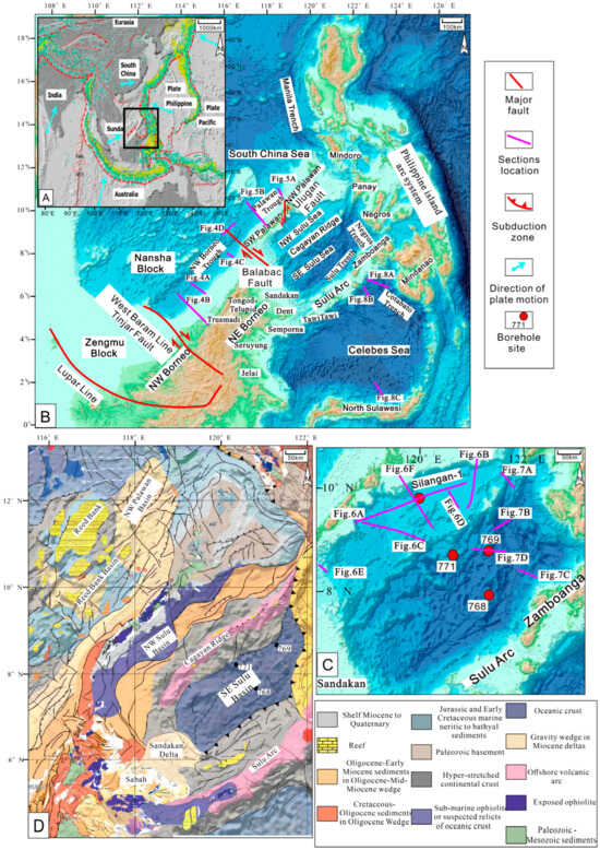
Figure 1.
(A) Plate tectonics and location of the study area. (B) Topographic and bathymetric map, tectonic units, and section locations in the circum-Sulu Sea region modified from GEBCO (2020) [33] (https://download.gebco.net. accessed on 30 October 2023). (C) Location sections and boroholes in the Sulu Sea. (D) Tectonic map showing the main structures and basement and sediment domains in the Sulu Sea (modified from Pubellier et al., 2018 [34]).

2. Tectonic Setting
The Sulu Sea is a small marginal sea basin that was formed by the compression and extension forces exerted by the Australia-India, Philippine Sea, and Eurasian plates in a convergent setting with multiple subduction zones (Figure 1A). The surface free-air gravity anomaly can reveal the present-day trench-island arc features in the area (Figure 2A). The Bouguer gravity anomaly roughly delineates the boundaries of tectonic activities in the area (Figure 2B). The complete spherical isostatic gravity anomaly (Airy–Heiskanen, Tc = 30 km) indicates the distribution of ophiolitic rocks, metamorphic rocks, magmatic arcs, and sedimentary basins (Figure 2C). Typically, sedimentary basins are characterized by negative gravity signatures (<0 mGal). Moderate gravity anomalies (0 to 80 mGal) are indicative of metamorphic rocks. Conversely, very high-gravity anomalies (>80 mGal) are representative of ophiolitic basement rocks. It can be seen that the negative gravity anomalies (<0 mGal) in the NW Sulu Sea correspond to sedimentary basins, while the SE Sulu Sea is characterized by ophiolitic basement oceanic crust features (>80 mGal) (Figure 2C). The NW and SE Sulu seas are recognized as distinctive structural domains with different basin architecture and tectonic settings. The main tectonic events since the Miocene are highlighted below (Figure 3).
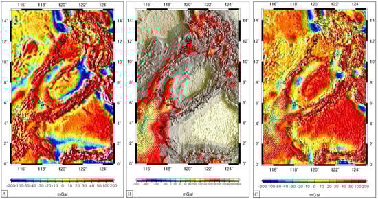
Figure 2.
(A) Surface free–air gravity anomaly. (B) Regional map of Bouguer gravity anomalies. (C) complete spherical isostatic gravity anomaly (Airy–Heiskanen, Tc = 30 km) (from the World Gravity Map (WGM) [35]).
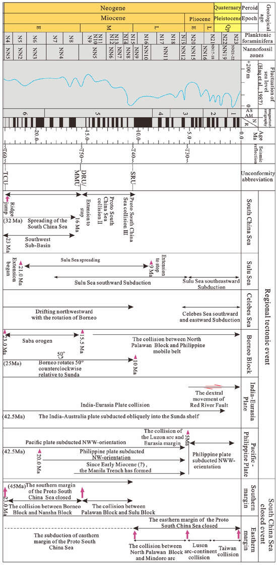
Figure 3.
Major tectonic unconformities and regional tectonic events related to the evolution of the Sulu Sea since the Miocene (biostratigraphic age from Lourens et al., 2004 [36]; sea level curve [37]).
2.1. Proto-South China Sea Subduction-Collision
The timing of the PSCS (after the definition in [14,38]) subduction and collision events involving the Palawan Continental Terrane (PCT) (encompassing northern Palawan and western Mindoro), NW Panay, Reed Bank-Dangerous Grounds, the PMB, and northern Borneo remains uncertain (e.g., [4,5,6,7,8,9,39,40]). The estimated age range for the collision varies significantly, spanning from the late Early Miocene (~20 Ma) [41] to Late Miocene (~10 Ma) [42]. Generally, the PSCS originated during the Late Mesozoic as a result of the convergence between the South China continent and Borneo. It subducted in a southward direction and eventually descended beneath Borneo from the Eocene to the Miocene. Differences in hypotheses from different independent regional studies suggest that ocean basin opening/subduction and collision may be diachronous [43,44]. The ongoing subduction and collision processes of the PSCS resulted in substantial alterations to the paleogeographic patterns of tectonic plates in the southern SCS. The southern boundary of the SCS is characterized by the collision zone of the Zengmu Block, the Nansha Block, the Borneo Block, and the Cagayan Ridge, which is also considered as the PSCS extinction zone. The southern margins of the SCS exhibit multiple segmented subduction-collision processes, displaying diverse tectonic effects and significant variations in sedimentary responses, recording the extinction process of subduction-collision of the PSCS. During the PSCS subduction process, the Sarawak and Sabah Orogenies occurred in southern SCS, leading to collision and contractional deformation of the southern margins. The southern basins of the SCS exhibit foreland compression characteristics, with continental margin compression and uplift supplying ample provenance to the southern basins, thereby fostering the formation of large deltas. Deltas have been forming in the southern part of the Zengmu Basin since the Oligocene, and in the Brunei-Sabah Basin, located on the eastern side of the Zengmu Basin, since the Miocene [4,5,6,43,44]. The southern subduction-collision tectonic zone can be divided into three tectonic zones, from west to east: the NW Sarawak-Zengmu Block collision zone in Borneo, the NE Sabah-Nansha Block collision zone in Borneo, and the SW Palawan-Cagayan Ridge collision zone in NW Sulu Sea [43,44]. The Zengmu, Nansha, and Liyue-Palawan Blocks, separated by the West Baram Line and Balabac Fault, have undergone sequential collisions with the Borneo Block and Cagayan Ridge from the west to the east, leading to the development of multiple foreland basin systems from the Late Eocene to Middle Miocene. Simultaneously, extension and closure of the PSCS occurred from west to east.
2.2. Borneo Rotated Counterclockwise and Sabah Orogeny
Borneo is located at the rotational convergence center of three tectonic plates: the Eurasian Plate, Australian Plate, and Philippine Sea Plate. Paleomagnetic data show that Borneo has undergone a counterclockwise rotation of nearly 90° since the Late Cretaceous [45]. This rotation is unique to Borneo and has not been recorded in surrounding blocks [45]. The largest rotation occurred from the Late Cretaceous to Early Eocene, when Borneo underwent approximately 45° of counterclockwise rotation. During the Late Eocene (41–39 Ma), Borneo rotated counterclockwise by about 35° and rotated approximately 10° in the Middle Miocene [9]. The rotation of Borneo is attributed to the collision between the Australian and Eurasian plates. The collision of the two plates occurred at the southwestern edge of the Borneo Block, causing Borneo to rotate counterclockwise and providing space for plate compression and consumption [1,45]. The initial subduction of the PSCS in the Sabah and Cagayan Ridge and/or the rotation of Borneo may have led to the major uplift of the Rajang Unconformity at 37 Ma [14,46].
The PSCS began subducting beneath Sabah in the Early Eocene, culminating in the collision between the Dangerous Grounds and Borneo, which is known as the Sabah Orogeny (~20 Ma). Hutchison [47] first proposed the concept of the Sabah Orogeny, suggesting that the collision between the Borneo and Dangerous Grounds was episodic. Multiple Middle Miocene unconformities developed from Sabah to the Brunei-Sabah Basin [4,5,6]. Hybrid event beds and both aseismic and seismic sedimentary deformation structures can be observed in the Crocker Fan of the Sabah region [4,5,6,48]. These massive sandstone beds in the Crocker Fan exhibit lithological heterogeneities, suggesting that they are the results of multiple events and processes in deep-marine settings [4,5,6,48]. The Top-Crocker Unconformity (TCU: 23–20 Ma [14]) along the Sabah coast and the Deep Regional Unconformity (DRU: 15.5 Ma [14]) in the Brunei-Sabah Basin are both results of the Sabah Orogeny. TCU refers to the upper contact of the Temburong and West Crocker/Crocker formations [4,5,6,48]. Before Hall and Brietfeld [14], Jackson et al. [49] suggested the term Base Miocene Unconformity (BMU) for the identical contact, which Lunt [50] later established as equivalent to TCU. The initial literature marked the DRU, previously thought to be the upper contact of the West Crocker Formation [14], but recent work has shown that it only marks the upper contact of Setap Shale [21,49,51]. Therefore, the DRU is younger than previously believed. It separates deep marine sediments from younger shallow marine to fluvial strata [52]. The Sabah Orogeny caused the formation of a regional unconformity interface (T50 interface) in the southern SCS (Figure 3), characterized by intense erosion and significant topographic variations. This interface corresponds to a regional tectonic event in northern Borneo from the Early to Middle Miocene (17–15 Ma) and the DRU in the Zengmu Basin, Beikang Basin, and Brunei-Sabah Basin (Figure 3) [53,54]. This tectonic event signifies the cessation of the extensional activities in the SCS and also constitutes a significant tectonic boundary that caused the transition of southern margin basins in the area (such as the Brunei-Sabah Basin, SW Palawan Basin, and Reed Bank Basin) into foreland basins. The Shallow Regional Unconformity (SRU), another distinct regional unconformity, potentially originated at 11–10 Ma as a result of a regional extension event [21]. The Middle Miocene Unconformity (MMU), which was occasionally referenced interchangeably with the DRU (Figure 3), is indeed a well-delineated geological feature offshore Sarawak. However, its age estimates vary significantly, ranging from 16 to 12 Ma across diverse locations in Sabah and the southwestern Philippines [55].
In SE Borneo, below the Celebes Sea and Dent-Semporna peninsulas, most geological findings suggest a NE–SW compressional force. Conversely, the areas further north, particularly beneath the NE Sabah coast and the Sulu Sea, indicate primarily NW–SE extensional forces, along with some evidence of strike-slip movements [56]. Moreover, the estimates of crustal thickness have indicated a level of thinning in the crust that aligns with the exposed ophiolite, stretching from the Sulu Sea toward Telupid [57,58,59]. Extension resulted in subsidence and uplift in various locations and was accompanied by magmatism. The ongoing deformation currently observed can be attributed to the movement of the deeper crust and topographically induced stresses [22]. Northern Borneo has undergone extensional tectonic processes, potentially persisting until the Late Miocene, followed by uplift from the Late Miocene to Early Pliocene [21,22].
2.3. NW Philippine Sea Plate Subduction
Since 47 Ma, the Pacific Plate has been moving in a NWW direction while the Philippine Sea Plate has drifted and rotated in a NW–NWW direction [1,2,60]. During the Oligocene (34–23 Ma), the Philippine Sea Plate began to move northward, accompanied by clockwise rotation. At the end of the Oligocene (25–23 Ma), the NWW motion of the Pacific Plate accelerated [1,60], with the Australian Plate rapidly subducting northward. The collision between the southern subduction zone of the Philippine Sea Plate and the northern segment of the Australian Plate caused the Pacific Plate to subduct toward the Philippine Sea Plate and impede northward movement of the Philippine Sea Plate. The Philippine Sea Plate gradually moved in a NNW direction, causing the Philippine arc and its western subduction zone to rotate clockwise and wedge beneath the Eurasian Plate and the Pacific Plate. The oblique convergence between the Philippine Sea Plate and Eurasian Plate formed the left-lateral strike-slip fault in the Philippine Island arc system [61]. At 10 Ma, the Philippine Island arc continued to move toward the NWW direction and reach the eastern SCS [62], where it collided with the Palawan Microcontinental Block, triggering the transformation of the strike-slip boundary in the eastern SCS basins into a subduction zone.
The Philippine Island arc system (Figure 1B), situated on the eastern flank of the Sulu Sea, comprises two primary terranes: the Palawan-Mindoro Microcontinental Block, once an integral segment of mainland Asia, coexisted alongside the PMB, whose origin can be traced to the sub-equatorial regions [11,24,26,63]. The PMB is a dynamic area situated at the intersection of two contrasting and dipping subduction systems [24,63,64,65] (Figure 1B). Its eastern periphery is demarcated by the west-oriented East Luzon Trough and the Philippine Trench [63,66]. Meanwhile, the western flank comprises southeast-oriented subduction zones, notably the Manila, Negros, Sulu, and Cotabato Trenches [63].
2.4. Celebes Sea Subduction
The Celebes Sea is considered to be a back-arc basin or marginal sea, and its formation is related to the subduction within the Indian Ocean during the Early Eocene [2,7,11,67]. During the Early Eocene (50–45 Ma), the subduction of the Indian Ocean crust led to the opening of the Celebes Sea through a back-arc basin mechanism, followed by extension. In the Late Eocene (40–30 Ma), the Celebes Sea ceased its extension at ~36 Ma [2,67].
The widely accepted viewpoint regarding the subduction of the Celebes Sea oceanic crust is that it started subducting southward beneath northern Sulawesi and eastward beneath Mindanao in the Early Pliocene (~5 Ma) [2,25,31,67]. However, the question of whether the Celebes Sea oceanic crust subducted northward during the early to late Middle Miocene remains unresolved. The Sulu arc is located to the north of the Celebes Sea. The origin of the Sulu arc has been the subject of longstanding debate, with some proposing that it was formed by south-dipping Sulu Sea subduction [23,24,25] while others have suggested north-dipping Celebes Sea subduction [1,2,21]. The main reason for this confusion is the lack of direct and clear evidence to demonstrate the existence of the fossilized accretionary prism at the SE and/or NW flank of the Sulu arc. In eastern Sabah, Tongod-Telupid ophiolite, volcanics in the Dent (18.8–17.9 Ma) and Semporna (18.2–14.4 Ma) peninsulas, and arc magmatism in Jelai and Seruyung were explained to be related to the north-dipping subduction of the Celebes Sea in the Miocene [12,13,68]. However, this island arc magmatic magmatism can also be explained by the Miocene south-dipping subduction of the SE Sulu Sea leading to NW–SE extension in eastern Sabah [22,44,56], even though these island arcs are now located at a considerable distance from the Sulu Sea. This is due to the fact that eastern Sabah has undergone the collision of different tectonic units, counterclockwise rotation of Borneo since the Miocene, and southward drift since the Pliocene [31]. The Celebes Sea exhibits an asymmetric distribution of magnetic anomaly bands, with relatively well-preserved magnetic anomaly bands on the northern side towards the Sulu arc, while fewer magnetic bands are preserved on the southern side facing North Sulawesi [67]. In other words, the distribution of magnetic anomaly bands in the Celebes Sea solely supports the southward subduction of the Celebes Sea oceanic crust [7,69,70]. In addition, the north-dipping subduction of the Celebes Sea is difficult to explain the extension of the NW Sulu Sea and the mechanism of the inward subduction of plates in the Celebes Sea and PSCS. The south-dipping subduction during the Miocene, which resulted in the elimination of the southern portion of the SE Sulu Sea oceanic crust, likely induced back-arc extension to the southeast of the Sulu arc. This process also led to the formation of significant transform faults along the northeastern and southwestern margins of the Sulu Sea to accommodate the subduction of the Philippine Sea Plate [11,31,68].
3. Sulu Sea Tectonic and Sedimentary Comparison
The margins of the Sulu Sea have undergone multiple stages of complex tectonic processes from subduction to collision, resulting in distinct sedimentary responses. Its northern margins record the evolution of the NW Sulu Sea and the closure process of the PSCS from subduction to the collision of microplates, while the southeastern margins record the extension and subduction processes of the SE Sulu Sea. The definition of the initial continental collision remains controversial, with the general consensus being the disappearance of oceanic crust between converging plates and the onset of contact between continental crusts [71], also known as “soft collision”(whereas intense crustal shortening and thickening occurring in converging continental blocks are referred to as “hard collision”). The differences in sedimentary responses between adjacent plates from subduction to collision mainly manifested in the following aspects [72]. (1) Changes in sedimentary facies: the subduction phase typically formed subduction trenches dominated by deep-sea pelagic sedimentation, while the accretionary wedge of the upper plate consisted of oceanic crust fragments (such as pillow basalts, ophiolite, and ophiolite complexes) and deep-sea sedimentary strata scraped off by the overlying plate. As the collision phase progressed, the environment gradually transitioned from deep-sea trenches to residual basins, and the sedimentary environment shifted from deep water to shallow water. In the early stages of collision along the northern margins of the Sulu Sea and subduction phase along its southern margins, deep-sea mudstone interbedded with turbidites developed, while in the main collision phase (hard collision period) along its northern margins, deltaic and nearshore shallow water sedimentation occurred. Despite the continent–continent collision, the southern margin basins of the SCS were still influenced by thermal subsidence following the expansion of the SCS, maintaining marine sedimentary environments. The terrestrial and foreland sedimentation only developed in the northern mountainous regions and coastal zones of Borneo. (2) Variations in the intensity of magmatic activity: volcanic activity typically occurred during the subduction phase and not during the collision phase. The southern margins of the Sulu Sea represent a subduction volcanic island arc zone, whereas the northern margins comprise foreland basins formed by collision.
Different tectonic zones in the margins of the Sulu Sea preserve rich tectonic remnants and sedimentary responses formed by ocean-arc subduction, arc–continent collision, and continent–continent collision. The distinctive tectonic setting of the Sulu Sea allows for the examination of the subduction and collision processes around the Sulu Sea through the analysis of tectonic activities and sedimentary deposition.
3.1. Subduction-Collision Tectonic Zone in Northern Margins of the Sulu Sea
The northern margins of the Sulu Sea have undergone a long history of Cenozoic subduction of the PSCS and its interactions with the NW Sulu Sea. The widely accepted model is that the PSCS subducted and disappeared beneath Borneo during the Cenozoic, but its subduction-collision process is disputed [40,43,44,73]. Remarkably, the NE Borneo–Palawan Troughs have long been presumed as either actively functioning or relatively young subduction zones (e.g., [19,20,56,74]). However, more recent research indicates that they were actually created by the flexure of the sediment wedge due to gravity-driven forces (e.g., [14,21]). Based on the zonation of subduction-collision in the southern and eastern SCS [43,44], the northern margins of the Sulu Sea can be divided into the Sabah-Nansha Block collision zone, SW Palawan-Cagayan arc collision zone, and NW Palawan-Mindoro arc collision zone.
3.1.1. Sabah-Nansha Block Collision Zone
The Sabah-Nansha Block collision zone belongs to a continent–continent collision zone, with the Tinjar-West Baram suture zone adjacent to the Zengmu Block on its western side, and its eastern boundary marked by the Balabac Fault. The Tinjar-West Baram suture zone accommodated the rotation and deformation of Borneo. The SCS margins of this zone comprise the Brunei-Sabah Basin, the Nansha Trough Basin, and the Beikang Basin.
The Zengmu Block and Nansha Block are bounded by the West Baram Line (Figure 2B). In the Bouguer gravity anomaly data, this fault is identified as the demarcation between regions of high positive and low anomaly values [75]. The dextral strike-slip motion along the West Baram Line predominantly occurred from the Eocene to Early Miocene (45–16 Ma) when the PSCS subducted [14,50]. During the Late Miocene–Quaternary, the West Palawan Fault exhibited a sinistral movement due to the relative displacement between the Nansha Block and the Zengmu Block. The Balabac Fault serves as a distinct boundary, distinctively separating Borneo Island from Palawan Island (Figure 2B). Analysis of the Bouguer gravity anomaly map indicates a significant horizontal gradient, with distinct magnetic anomaly trends on either side. The magnetic anomaly pattern on the northeast side generally trends northeastward, while on the southwest side, it aligns nearly east-west [75].
The Sabah region in the northeastern flank of the Tinjar Fault is composed from south to north of the Trusmadi Mountain Range, the Crocker Mountain Range, and the Western Lowland coastal plain (Figure 1B). The Trusmadi Mountain Range is composed of phyllite and killas formations dating from the Eocene to the Oligocene, roughly equivalent to the Rajang Group in the Sarawak. Its uplift process is a result of the Sarawak Orogeny [73]. The Crocker Mountain Range consists of unmetamorphosed sandy flysch (West Crocker Group) with the Late Eocene to Oligocene West Crocker Group being deep-sea turbidite fan deposits [4,5,6,73]. The Crocker Group unconformably overlies the strongly deformed Rajang Group, marked by a top unconformity interface (TCU) [4,5,6,73]. The TCU was subsequently overlain by the Lower Miocene Meligan Group and the Setap Group, with the former dominated by river delta deposits and the latter dominated by shallow marine mudstone deposits. Above these units, the DRU unconformity interface developed, and above this interface is the Belait Group sedimentation, representing a transition from marine to continental environments [4,5,6,51].
Two fold and thrust belts have developed along the Sabah coast and the Brunei-Sabah Basin (Figure 4A,B). The lower fold and thrust belt is mainly distributed in northern Sabah including the Crocker Range and coastal plains. The involved formations in the fold and thrust belt are predominantly from the Crocker Group, with the Crocker Fan distributed in northern Sabah and offshore areas (Figure 4B). The upper fold and thrust belt is primarily distributed in the Sabah coastal plains and the Brunei-Sabah Basin, with its leading edge extending to the Nansha Trough (Figure 4A). The involved formations in the upper fold and thrust belt are mainly from the Middle to Late Miocene strata and above (Figure 4A). The lower fold and thrust belt is a product of the Sabah Orogeny, which mainly occurred in the region east of the West Baram Line, specifically in the NE Sabah region of Borneo and SW Palawan Island. Oligocene–Middle Miocene Nido platform carbonates were beneath the thrust allochthonous wedge of the NW Sulu Sea (Figure 4C). This collision event exhibits a clear eastward younging trend, with the collision period ranging from 22.0 to 15.5 Ma. The collision began at the late Oligocene to the early Middle Miocene, with the formation of the unconformity interface in the northwest Borneo dated to 22–20 Ma, referred to as the Top of Crocker Unconformity (TCU), while others refer to it as the Basement of Miocene Unconformity (BMU) (Figure 4) [76]. The collision ceased at the end of the Early Miocene (15.5 Ma), forming the T50 unconformity interface (DRU). This tectonic activity led to intense fold and deformation in the northern Sabah region.
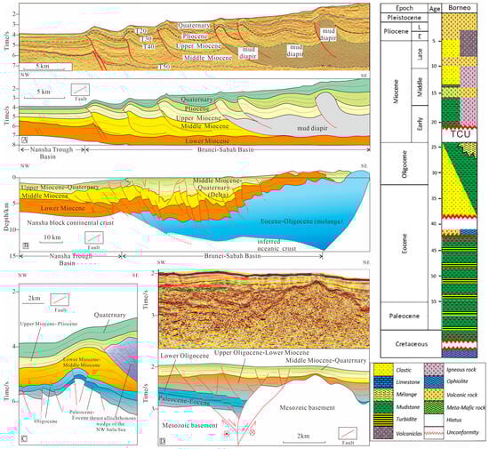
Figure 4.
Seismic profiles (left) and schematic stratigraphy of Borneo (right) showing the features of northeast Borneo. (A,B) show the features of the fold and thrust belt in the Brunei-Sabah Basin (A modified from Hesse et al., 2009 [19]. B modified from Sandal, 1996 [18]). (C) shows Oligocene–Middle Miocene Nido platform carbonates below the thrust allochthonous wedge of the NW Sulu Sea (modified from Schlüter et al., 1996 [15]). (D) shows the “Y” shaped flower-like structure of the Balabac fault, extending eastward to the NW Sulu Sea (Figure 1) (modified from Zhu et al., 2019 [77]). The schematic stratigraphy is from Lai et al., 2019 [13]. The locations of these sections are depicted in Figure 1B.
The upper fold and thrust belt is in the strata above the Middle Miocene, with the footwall of the thrust detachment surface composed of Middle Miocene mudstone (Figure 4A). Seismic profiles have revealed that this fold and thrust belt developed in the deepwater area, hence referred to as deepwater fold and thrust belt. A series of reverse faults and fold structures developed along the southern Nansha Trough and the Brunei-Sabah Basin [19,53,78]. Since the Middle Miocene, large deltaic deposits developed in the eastern flank of the West Baram Line, forming the Meligan Delta, Champion Delta, and Baram Delta at different times. The gravity sliding system developed as a result of the accumulation of thick delta deposits along the eastern flank of the West Baram Line in the Brunei-Sabah Basin and the southern Nansha Trough Basin. The seismic profile of the Brunei-Sabah Basin only revealed relatively gentle fold and thrust belts (Figure 4A). Multiple reverse faults formed camelback-shaped slope depressions, with the Pliocene delta distal turbidite deposits continuously filling in (Figure 4A). Consequently, the upper fold and thrust belt is the result of the combined effects of delta front gravity sliding and plate subduction since the Middle Miocene [79].
The “Y”-shaped flower structure of the Balabac fault indicates that the fault has undergone extensional strike-slip movements (Figure 4D). The Balabac fault has cut through the basement and the Cenozoic strata, suggesting that the fault remained active during the Cenozoic. The interpreted section shows significant differences on both sides of the fault plane, with the upper strata orderly and relatively flat on the hanging wall side, and the lower strata tilted at a higher angle on the footwall side (Figure 4D). The seismic reflection characteristics on both sides of the fault also differ, with the western side showing more continuous tabular and overlapping features, while the eastern side exhibits discontinuous hummocky features. The blocks on either side of the Balabac Fault may have different structural development histories. The Middle Miocene strata and above are well-layered, continuous, and gentle, indicating that although the Balabac Fault has been active since the Miocene, the scale of this activity has not been large. Since the Middle Miocene, the southward movement of the Liyue-Palawan Block has resulted in the transformation of the Balabac Fault into a northwest-trending dextral strike-slip fault.
3.1.2. SW Palawan-Cagayan Arc Collision Zone
The SW Palawan-Cagayan arc collision zone is delimited by the Balabac Fault to the west and the Ulugan Fault to the east, and is classified as a continental-arc collision zone. To the north lie the NW Palawan Basin and the Reed Bank Basin, while to the south are SW Palawan Island and the NW Sulu Sea. Palawan Island can be divided into two tectonic units with different origins along the Ulugan Fault (Figure 1B). SW Palawan Island belongs to an oceanic arc accretionary wedge, while the northern Palawan Island is a microblock of continental crust origin. SW Palawan Island is extensively composed of Mesozoic ophiolite and Eocene to early Middle Miocene sandstone interbedded with mudstone, limestone, and metamorphic rocks [61]. The southern part of the SW Palawan-Cagayan arc collision zone is bounded by the NW Sulu Sea and the Cagayan Ridge [11]. The Cagayan Ridge extends from the southern tip of Panay Island southwestward to the Sandakan Basin in Sabah (Figure 1B). The Cagayan Ridge is divided into three segments by northwest–southeast oriented transform faults, parallel to the Balabac Fault [15]. Geological evidence suggests that the Cagayan Ridge has been tectonically active since the Early Miocene or earlier [23,24], and possibly as far back as the Early Oligocene [73]. The Cagayan Oligocene volcanic arc and the Palawan Trench were interpreted by Hamilton [74] as the convergent margin of an ancient island arc plate. The PSCS subducted beneath the Cagayan volcanic arc, resulting in the exposure of ophiolite and melange on SW Palawan Island.
The seismic profile of NW Palawan Basin shows low-angle tilting or nearly horizontal characteristics and stable tectonic setting (Figure 5A) [80]. The seismic profile of SW Palawan Basin revealed the fold and thrust belt (Pulute accretionary wedge) in the northern flank of SW Palawan Island (Figure 5B). The base of the thrust wedge is composed of the Eocene–Oligocene Nido limestone [20]. The leading edge of the thrust wedge extends to the central part of the Palawan Trench. The top of the wedge is covered by the Tabon limestone unconformity interface, and drilling on the SW Palawan shelf indicates its age ranging from 9 Ma to 5 Ma. Based on the ages of two sets of limestone formations, it can be inferred that the age of the collision zone in this belt is approximately 15–5 Ma [81]. Aurelio et al. [61] suggested that the SW Palawan foreland thrust wedge formed from 16 Ma to 12 Ma. The discovered unconformity interface at ~12 Ma is consistent with the abrupt change in sedimentary environment revealed by drilling in the area [82]. The profiles of the NW Sulu Sea revealed the oceanic crustal splinter ascending toward Palawan in this basin (Figure 6) [15]. Contraction led to the reactivation of rift related structures and formed new tectonic features across the NW Sulu Sea. The contraction was widespread from the Middle to possibly Early Miocene in the eastern NW Sulu Sea Basin (Figure 6A), possibly related to the collision of the Palawan Block with the PMB. However, the contraction, widespread in the western NW Sulu Sea Basin before the Miocene (Figure 6A,B), may be related to the collision of the Palawan Block and counterclockwise rotation of Borneo. The cessation of extensive contraction in the NW Sulu Sea during the Late Miocene may be associated with the formation of a megathrust plate boundary and the lateral propagation of subduction initiation along the deep-water SE Sulu Sea Trench [83].
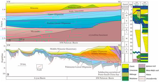
Figure 5.
Interpreted profiles (left) and schematic stratigraphy of the SW and NW Palawan Basins (right). (A) shows low-angle tilting or nearly horizontal characteristics and stable tectonic settings in the NW Palawan Basin (modified from Wang et al., 2020 [80]); (B) shows the fold and thrust belt in the SW Palawan Basin (modified from Hinz et al., 1985 [78]; Aurelio et al., 2014 [61]). The schematic stratigraphy is from Wang et al., 2019 [57]. The location of these sections is shown in Figure 1B.
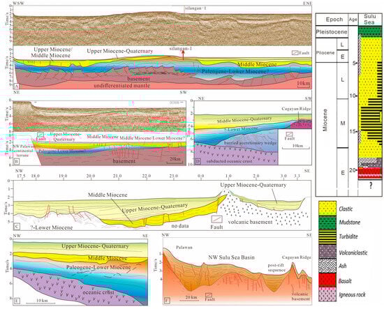
Figure 6.
Interpreted seismic cross profiles (left) and schematic stratigraphy (right) to depict the structure of the NW Sulu Sea. (A–C,F) show the features of fold and thrust belt and post-rift sequence in the NW Sulu Sea ((A,B) modified from Cadenas and Ranero, 2024 [83]; (C) modified from Rangin, 1989 [10]; F modified from Hutchison, 1992 [12]); (D,E) show the oceanic crustal splinter ascending in direction to Palawan in the NW Sulu Sea Basin (modified from Schlüter et al., 1996 [15]). The schematic stratigraphy is from Lai et al., 2019 [13]. The location of these sections is shown in Figure 1C.
3.1.3. NW Palawan-Mindoro Arc Collision Zone
The NW Palawan-Mindoro arc collision zone is a continent-arc collision zone between the Nansha Block and the Philippine Sea Plate. To the west are north Palawan Island and Busuanga Island, both of which belong to the PCT [41]. To the east are Mindoro Island and Panay Island in the Philippines. There is considerable debate regarding the timing of the collision between the north PCT and the Mindoro Island arc. Yumul et al. [84] suggested that the collision between the north PCT and the Philippine Sea Plate occurred in the Early to Middle Miocene, with the PMB as the boundary. The southwestern Philippine Island arc rotated clockwise during the Middle to Late Miocene and collided with the Sulu Sea and Celebes Sea, while the northern Luzon volcanic arc rotated counterclockwise during the Late Miocene and collided with the northeastern margin of the SCS. Another viewpoint proposes that the collision between the north PCT and the Philippine Sea Plate occurred in the Late Miocene (~10 Ma) [42]. Wu et al. [85] reconstructed the movement of the Philippine Sea Plate and suggested that the Philippine Sea Plate began to wedge from near the Equator in a northwest direction in the Eocene, with the initial collision occurring between the Mindoro Island arc and the north PCT at the termination of the Middle Miocene. The extension of the SE Sulu Sea occurred in the Early (C7: 23.96) to Middle Miocene (C5: 9.79 Ma), and the eastern subduction along the Negros Trench occurred in the Pliocene [13]. Therefore, this study argued that the timing of the collision between the north PCT and the Mindoro Island arc is more reasonably interpreted as occurring from the termination of the Middle Miocene to the beginning of the Late Miocene.
3.2. Subduction Tectonic Zone in Southern and Eastern Margins of the Sulu Sea
The evolutionary processes of the southern and eastern margins of the Sulu Sea involves the subduction history of the SE Sulu Sea including southern subduction during the Middle–Late Miocene and eastern subduction since the Pliocene. The crust in the SE Sulu Sea (~6 km) is thinner than the NW Sulu Sea (>10 km), and the former is also considerably deeper (4500–5000 m deep) than the latter (greatest depth: 1000–1800 m) [11,86]. The paleomagnetic anomalies interpreted for the basement in the southeastern Sulu Sea span a time range from 23.96 Ma (C7) in the northwestern region to 9.79 Ma (C5) in the southeastern region [87,88]. The Ocean Drilling Program (ODP Leg 124) has drilled into the sedimentary and pyroclastic rocks as well as the basement rocks comprising pillow/massive basalts, dolerite, and micro-gabbros at Sites 768, 769, and 771 within the SE Sulu Sea (Figure 1C, Figure 2, and Figure 7). The oldest recovered rocks consist of basaltic-andesitic lapillistone and tuff, likely originating from volcanic eruptions in a subaerial or shallow marine setting with limited sediment alteration. These volcaniclastic materials have been determined to be of Early Miocene age based on their stratigraphic position beneath early Middle Miocene claystone, which contains foram and radiolarian fossils. This age is consistent with the volcaniclastic deposits found at Site 768 in the SE Sulu Sea [89,90]. Silangan-1 borehole was drilled by the company Shell in the northeastern part of the NW Sulu Sea in 2010 at a water depth of ~1355 m to a total depth of ~2696 m (Figure 1). The borehole recovered Upper to Middle Miocene sediments, mainly consisting of siliciclastic sequences of siltstones, conglomerates, sandstones, and claystones [83].
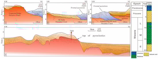
Figure 7.
Interpreted seismic cross-sections and schematic stratigraphy of ODP 769 [24] to illustrate the structure of the SE Sulu Sea. (A–C) Seismic reflection profiles document the accretionary prism (in gray) in the SE Sulu Sea. (D) Extension of the SE Sulu Sea in the southeastern flank of the Cagayan Ridge. (A–C) modified from Schluter et al., 1996 [15], and the reinterpretation, with colorization adapted from Nawanao and Ramos, 2023 [91]; (D) modified from Rangin and Silver, 1991 [24]). The location of these sections is shown in Figure 1C.
3.2.1. SE Sulu Sea Southward Subduction Zone
The SE Sulu Sea southward subduction zone extends from west to east including the Dent and Semporna in southeastern Borneo, the Sulu arc, and the western part of the Zamboanga Peninsula. The exposed ophiolitic complex around Telupid (central Sabah) (9 Ma) [92] and thinning of the crust extending from the Sulu Sea towards Telupid [57,58,59] suggest that the rifting in the Sulu Sea extended into what is now northern Borneo, but ultimately did not lead to significant seafloor spreading [22]. The extension induced by Sulu Sea rifting in northern Borneo may be attributed to southward subduction of the SE Sulu Sea.
The basement of the Sulu arc is separated from the SE Sulu Sea Basin by the Sulu Trench to the north, and it is a passive margin that is connected to the Celebes Sea Basin to the south [31]. Based on seismic analysis [10,86], the highly developed accretionary complex is linked to the Sulu Trench. The Sulu arc’s geological past is primarily discerned through comparisons with the Dent and Semporna Peninsulas situated in the eastern part of Sabah as well as the Zamboanga peninsula. The Dent and Semporna Peninsulas reveal volcanic rocks of andesitic to dacitic composition, with K-Ar dating indicating ages between 18.8 and 2.8 Ma [10,68]. Sedimentary rocks alternating with volcanic rocks in this area include tuffaceous chert, greywackes, and thick limestones formed during the Late Oligocene–early Middle Miocene [10]. This sequence is folded and unconformably covered by conglomerates and shales [93]. The basement of the Sulu arc is overlain by volcanic formations possibly dating from the Pliocene to Quaternary [86]. In particular, Tawitawi Island in the southern Sulu arc exposes (ultra-)mafic plutonic rocks overlain by marine clastic rocks [25]. The mélange may be exposed on the southeastern margin of the Sulu arc [74], while the northeastern slope of the Sulu arc comprises granodiorites, volcanic rocks, and Early Miocene limestones [25]. Mesozoic metamorphic rocks, volcanic cones, and terrestrial/marine sediments are also exposed on the other islands of the Sulu arc region. By gathering and thoroughly comparing geological information from various locations in the southern and eastern margins of the Sulu Sea [13], it is elucidated that the magmatic ages of the Dent and Semporna Peninsulas in the west and the Zamboanga Peninsula in the east concentrate on the Miocene, and the ages of the Zamboanga Peninsula show a progression from older to younger, from west to east.
3.2.2. SE Sulu Sea Southeastward Subduction Zone
The SE Sulu Sea southeastward subduction zone extends from south to north including the Zamboanga Peninsula, Panay, and Negros Islands (Figure 1B). Based on the magmatic ages of the Zamboanga Peninsula, the boundary of the southeastward subduction zone may spatially overlap with the southward subduction zone in the SE Sulu Sea. Unlike the southward subduction zone in the southeastern Sulu Sea, seismic reflection profiles document the accretionary prism in the SE Sulu Sea, representing a recent subduction zone (Figure 7A–C). Seismic cross sections revealed volcanic rocks superimposed over normal fault blocks along the southern flanks of the Cagayan Ridge, indicating break-up between the continental crust associated with the southeastward subduction of the SE Sulu Sea (Figure 7D) [13,15,24]. The partially metamorphosed accretionary complex underlying ophiolite on the northern side of the Zamboanga Peninsula imply the subduction of the SE Sulu Sea [94]. The ophiolite, mélange, and underlying metamorphic basement are unconformably overlain by Lower–Middle Miocene quartz-rich sandstones and interbedded limestones, siltstones, and claystones, and intercalated Middle Miocene to Pleistocene andesitic volcanic rocks [94]. Magmatism resumed after ~5 Ma in the region, particularly along the Zamboanga Peninsula–Sulu arc–SE Sabah [95,96,97] and Negros [29,98]. This stratigraphic succession indicates that the asynchronous magmatic activities occurred on the northern side of the Zamboanga Peninsula caused by subduction processes.
Particularly, the Celebes oceanic crust beneath the North Sulawesi and Mindanao accretionary prism illustrates its southward and eastward subduction (Figure 8). The Middle Miocene turbidite sequence constitutes the basal section of the thrust wedge, suggesting that thrusting began not earlier than the Middle Miocene (Figure 8A). Specifically, the positive flower structure between the Sulu arc and the Celebes Sea (Figure 8B) may indicate an oblique convergence of the southeastward subduction of the SE Sulu Sea and the northeastward subduction of the Celebes Sea after the Pliocene (Figure 8B). The cutting and deformation of the Pliocene sequences also indicate that the accretionary wedge formed after the Pliocene (Figure 8A,C).
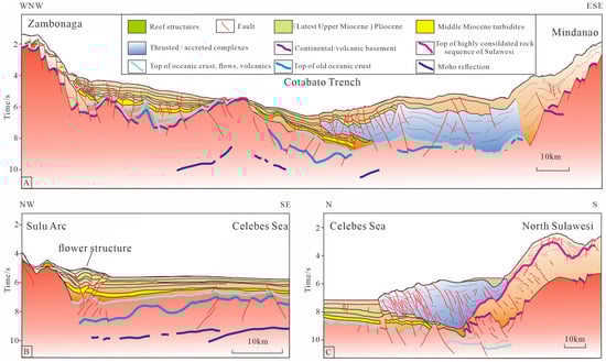
Figure 8.
Interpreted seismic cross sections to illustrate the collision and subduction of the Celebes Sea (modified from Schlüter et al., 2001 [25]). (A) Fold and thrust belt between Zambonaga and Mindanao. (B) Flower structure between the Sulu arc and Celebes Sea. (C) Collision and subduction of the Celebes oceanic crust beneath the North Sulawesi accretionary prism. The locations of these sections are depicted in Figure 1B.
4. Discussion
Gravity and magnetic studies have interpreted the NW Sulu basement as remnants of a Late Cretaceous to Eocene thick oceanic crust of a proto-NW Sulu Sea, obducted onto NE Borneo in the Late Eocene and subsequently onto the southern part of Palawan in the Middle Miocene, similar to ophiolite complexes [16]. Early PSCS subduction (pre–23 Ma) may have resulted in the opening of the NW Sulu Sea, as supported by the highly attenuated continental crust [13,89,90], and subsequently Early to Middle Miocene and pelagic sediment cover. Most studies have interpreted that the SE Sulu Sea Basin extended as a back-arc basin from the Early to Middle Miocene [10,11,15]. Extension and seafloor spreading occurred from the Early to Middle Miocene in the SE Sulu Sea Basin [10,12,13,87,90], while thrusting, folding, and transpression were activated in the NW Sulu Sea Basin [83]. Widespread contraction in the NW Sulu Sea Basin was inhibited by the lateral propagation of subduction initiation along the deep-water SE Sulu Sea Trench in the Late Miocene [83].
4.1. Evolution of Sulu Sea Arc–Basin System
The prominent feature of the northern margins of the Sulu Sea is the occurrence of multiple collision and compression events since the Middle Miocene. The TCU in the Sabah region formed at roughly 23–20 Ma. Based on outcrops and seismic profiles of the Brunei-Sabah Basin, the unconformity formed by the Sabah Orogeny was gradually younger from west to east, with the unconformity interface in the Brunei-Sabah Basin dated to the termination of the Early Miocene (15.5 Ma) [4,5,6,43,44]. It is inferred that the collision time caused by the Sabah Orogeny may be the Early Miocene (23–15.5 Ma). The fold thrust belt formed in SW Palawan, with the top and bottom plates of the thrust wedge constrained by two sets of limestone, inferring a collision time between 15.5 and 8 Ma. Additionally, two fold thrust belts can be observed in the Brunei-Sabah Basin, with the lower set being a product of the Sabah Orogeny, while the formation of the upper fold thrust belt may have been influenced by the Palawan event. Although some experts believed that the latter may have been formed by gravitational sliding caused by the accumulation of a large delta, the seismic profile of the area shows that this fold thrust belt is different from a purely gravity-driven system induced by gravitational sliding. It may be the result of the combined effects of delta front gravity sliding and regional compressional stress. The development of fold thrust belts in the Brunei-Sabah Basin and Palawan Basin in the Middle–Late Miocene indicates that since the Middle Miocene, this region has undergone a new collision event. Seismic profiles and drilling in the SW Palawan Basin have revealed the development of the unconformity interface (~12 Ma) [82]. The Cadlao-1 well in NW Palawan shows significant sedimentary environment changes above and below the unconformity interface, with semi-deep sea mudstone deposition below the interface and the development of small deltaic sandstone deposition above it. The development of fold-thrust belts and environmental changes may be related to a large-scale uplift event caused by the collision between the Liyue-SW Palawan Block and the Cagayan Ridge. It can be inferred that the collision between SW Palawan and the Cagayan Ridge occurred slightly earlier than the collision between north PCT and the Mindoro Island arc.
The southeastern margins of the Sulu Sea have typically undergone a subduction phase, resulting in the formation of subduction trenches where deep-sea pelagic sediments filled and thrust wedges occurred. The main feature is presented from west to east as follows: the Dent and Semporna Peninsulas, the Sulu arc, the Zamboanga Peninsula, and the Panay and Negros Islands exhibit a trend toward gradually younger magmatic ages [13].
In summary, combined with the evolutionary processes of the southern and eastern margins of the SCS [43], the Balabac Fault and Ulugan Fault respectively constitute the boundaries of three collision zones in the northern margins of the Sulu Sea (Figure 9 and Figure 10). The Dent and Semporna Peninsulas, the Sulu arc, the Zamboanga Peninsula, and the Panay and Negros Islands exhibit the different features of two subduction zones in the southern margins of the Sulu Sea (Figure 9 and Figure 10). The prototype and sedimentary filling patterns of the Sulu Sea arc–basin system are closely related to the collision of blocks and their respective positions, resulting in a gradual process of the subduction/collision of different blocks from west to east. The evolution of the Sulu Sea arc–basin system can be divided into the following three stages (Figure 10). (1) Early Miocene (23–15.5 Ma): As a result of the southward subduction of the PSCS [9,40], NE Sabah was characterized by continent–continent collision in the northern margins of the Sulu Sea, leading to the Sabah Orogeny and the contractional deformation of NE Borneo, forming the foreland basin system in the Brunei-Sabah Basin–Nansha Trough–Nansha Block, whereas Palawan demonstrated the trait of ocean–arc collision, with an accretionary wedge in SW Palawan Island. During this period, the NW Sulu Sea continued to extend, and the southwestern part of the NW Sulu Sea exhibited deformation dominated by gravity-driven compaction [83]. (2) Middle to Late Miocene (15–5 Ma): The subduction of the PSCS in the Palawan region led to a continent–arc collision, resulting in its closure. In SW Palawan Island, the ophiolitic complex was exposed, with Early Miocene limestones and clastic sediments developing in the northern margin of the island. The collision between the Liyue-Palawan microblock and the Sulu Block in the Cagayan Ridge occurred at ~11 Ma, with the fold thrust belt in this zone constrained by two sets of limestones, indicating a collision significantly later than the Sabah Orogeny. The seismic profiles revealed the occurrence of deltaic sediments above an unconformity at 12 Ma. Due to the limited exhumation area in SW Palawan, the size of the delta is relatively small. The counterclockwise rotation of Borneo not only resulted in a change in the direction of collisional structures, but also led to the collisional diachronism of the northern margins of the Sulu Sea, exhibiting a characteristic of a gradually younger transition from west to east. The SE Sulu Sea extended and subducted southward, triggering magmatic activities in the Dent and Semporna Peninsulas in southeastern Borneo, the Sulu arc, and the western part of the Zamboanga Peninsula island. Based on paleomagnetic anomaly C5 (9.79 Ma), the extension of the SE Sulu Sea may cease in ~9 Ma. In the Late Miocene, the collision between the north PCT and the Philippine Island arc on Mindoro Island primarily caused the contraction and deformation in the eastern NW Sulu Sea. (3) Since the Pliocene (5 Ma onward): As the Philippine Sea Plate persisted in its northwestward movement, multiple collision zones formed in the northern margins of the Sulu Sea, while the southern part underwent oceanic crust subduction. The SE Sulu Sea subducted southeastward, ultimately forming the present-day morphological combination of a trench-accretionary wedge-volcanic arc. The widespread contraction in the NW Sulu Sea also ceased.
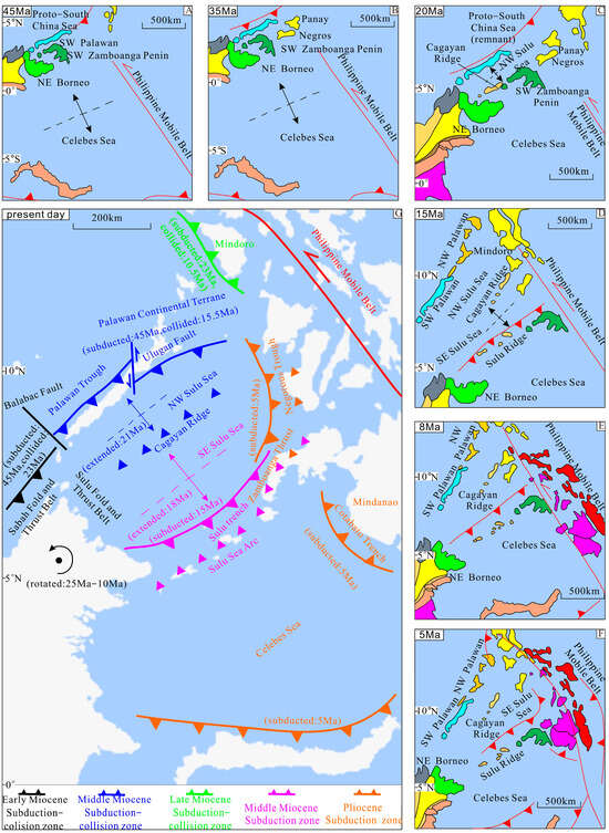
Figure 9.
Tectonic evolution pattern and asynchronous subduction and collision zones for the Sulu Sea and its surrounding region (modified after Lai et al., 2021 [13]; Advokaat and van Hinsbergen, 2024 [31]). (A) 45 Ma: The PSCS subducted; the Celebes Sea began to expand, and its oceanic crust is connected to the expanding West Philippine Sea through a transform fault zone (PMB). (B) 35 Ma: Onset of the SCS spreading, the southward drift of Palawan Continental Terrane (PCT). (C) 20 Ma: Initial Opening of NW Sulu Sea. (D) 15 Ma: The expansion of the SCS Basin ceased. PCT arrived the present location. The SE Sulu Sea extended and subducted toward the south. (E) 8 Ma: the extension of the SE Sulu Sea ceased. The collision between the north PCT and the Philippine Island arc on Mindoro Island primarily caused the contraction and deformation in the eastern NW Sulu Sea. (F) 5 Ma: The SE Sulu Sea subducted southeastward. The widespread contraction in the NW Sulu Sea also ceased. The Celebes Sea subducted toward the east and south. (G) Asynchronous subduction and collision zones show in the present Sulu Sea.
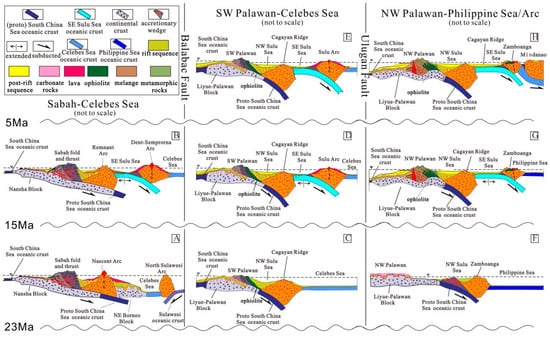
Figure 10.
Zoning and evolutionary models of the subduction and collision zones in the circum-Sulu Sea since the Miocene (modified after Rangin et al., 1989 [10]; Rangin and Silver, 1990 [11]; Xie et al., 2022 [43]). (A,B) show the sections from Sabah to Celebes Sea. (A) 23–15 Ma: The PSCS subducted and collided with Sabah–Nansha Block, and Sabah fold and thrust developed. (B) 15–5 Ma: The SE Sulu Sea extended and subducted toward the south beneath Dent–Semprorna Arc. (C–E) show the sections from SW Palawan to Celebes Sea. (C) 23–15 Ma: The PSCS subducted beneath Cagayan Ridge, resulting in the exposure of ophiolite and melange on SW Palawan Island. (D) 15–5 Ma: The PSCS collided with Cagayan Ridge, and arcthrusting, folding, and transpression were activated in the NW Sulu Sea Basin. The SE Sulu Sea extended and subducted toward the south beneath Sulu Arc. (E) 5 Ma onward: The widespread contraction in the NW Sulu Sea and the extension of SE Sulu Sea ceased. (F–H) show the sections from NW Palawan to Philippine Sea/Arc. (F) 23–15 Ma: The PSCS subducted beneath Zamboanga, while the PCT drifted southward. (G) 15–5 Ma: The PSCS collided with Cagayan Ridge. The SE Sulu Sea extended and subducted toward the south beneath Zamboanga. (H) 5 Ma onward: The Celebes Sea subducted toward the east beneath Mindanao.
4.2. Plate Tectonic Evolution Pattern
The circum-Sulu Sea subduction system is an important part of the Southeast Asian circular subduction system (Figure 9). Based on previous studies, especially the development time of accretionary wedges (Figure 4C, Figure 5B, Figure 6D, Figure 7A–C and Figure 8A,C), the circum-Sulu Sea subduction system can be classified into distinct zones based on geological periods: the Early Miocene subduction-collision zone, Middle Miocene subduction-collision zone, Late Miocene subduction-collision zone, Middle Miocene subduction zone, and Pliocene subduction zone (Figure 9G).
The formation and evolution of the circum-Sulu Sea subduction system have primarily been influenced by the activities and reorganization events of the Eurasian, Pacific, Philippine Sea, and India-Australia Plates. The Indian Plate and Australian Plate continuously drifted northward with differential velocities. Eventually, the Indian Plate collided with the western side of the Eurasian continent, while the Australian Plate on the southern side of the Sulu Sea drifted northward and collided with the Sunda Block. Therefore, it is imperative to comprehensively consider the combined effects or constraints of these aspects to achieve a more profound comprehension of the evolutionary process of the circum-Sulu Sea subduction system.
Middle–Late Eocene (47–34 Ma): The Pacific Plate has undergone northwestward movement [1,85]. Subsequently, the West Philippine Sea has continued to expand and rotate clockwise. Meanwhile, in the Neo-Tethys Oceanic domain, the Indian Plate and the Eurasian Plate initiated a “hard” collision. Under the combined effects of these two major tectonic domains, the regions including the SCS and the East China Sea continental shelf basins were situated within a background of right-lateral extensional stress field. Due to the sudden northward acceleration of the Australian Plate, Sumatra and the SCS to its north have undergone compression, causing the PSCS to subduct beneath the Borneo microcontinent [1]. Influenced by this back-arc extension, the Celebes Sea began to expand, and its oceanic crust is connected to the expanding West Philippine Sea through a transform fault zone (PMB) [2].
Oligocene (34–23 Ma): The SCS began its initial expansion, while the Liyue-NE Palawan microplate located at the southeastern margin of the South China Block started drifting southward [17]. The PSCS gradually became extinct, and the expansion of West Philippine Sea Basin ceased. During this period, the Philippine Sea Plate has persisted in its northward movement, accompanied by a clockwise rotation. At the termination of the Oligocene (25–23 Ma), the northwestward movement of the Pacific Plate accelerated [60], the Australian Plate rapidly subducted northward, and collision occurred between the south subduction zone of the counterclockwise rotating Philippine Sea Plate and the north segment of the Australian Plate. This collision caused the Pacific Plate to subduct beneath the Philippine Sea Plate and prevented its northward movement. Influenced by these collision and subduction activities, the Philippine Sea Plate gradually moved in a NNW direction during its clockwise rotation. The Philippine arc and the western subduction zone rotated clockwise and wedged between the Eurasian Plate and the Pacific Plate. At this time, due to the counterclockwise rotation of the Borneo microplate, the subduction zone on the southern side of the PSCS changed its trend from nearly EW to NE, resulting in the drag force in the PSCS plate shifting to the SE, and the formation of the Cagayan Ridge on the northeastern side of Borneo [89].
Early–Middle Miocene (23–15.5 Ma): After 23 Ma, the Philippine Island arc continued to move in a northwestward direction toward the eastern SCS, colliding with the Palawan microcontinental block, triggering the transformation of the strike-slip boundary in the eastern SCS basins into a subduction zone. As a consequence of the southward subduction of the PSCS, the NW Sulu Sea extended further. The eastern oceanic crust of the SCS began to subduct westward beneath the Philippine Sea, forming the Manila Trench [63]. By this time (23–15.5 Ma), the initial formation of the eastward subduction of the central subduction system in the circular subduction system of Southeast Asia also took place.
Middle–Late Miocene (15–5 Ma): The expansion of the SCS Basin ceased, and the subduction along the Manila Trench continued eastward beneath the West Philippine Sea. The West Philippine Sea Plate to the east of the Luzon Island arc subducted toward the northwest along the Eurasian Plate, exhibiting a bidirectional subduction beneath Luzon Island. The SE Sulu Sea extended and subducted toward the south.
Since the Pliocene (5 Ma onward): The westward-moving West Philippine Sea Plate collided with the Eurasian continent in the Taiwan region, resulting in the initiation and gradual formation of Taiwan Island [99]. Subsequently, the SE Sulu Sea and the Celebes Sea subducted toward the east beneath the Philippine Island arc along the Negros Trench and Cotabato Trench, respectively [13].
4.3. Implications on the Dynamics of Adjacent Marginal Seas of the Sulu Sea
The characteristics of magnetic anomaly belts in the Sulu Sea are parallel to those in the Celebes Sea Basin and the SCS [69]. Therefore, the formation and evolution of the Sulu Sea can enhance our comprehension of the expansion and subduction in the SCS, and even offer important insights for the circular subduction system of Southeast Asia [24,31,90]. Multiple collisions and compressions along the southern continental margin of the SCS have led to the collision and accretion of multiple microcontinental blocks. The entire closure process progresses from the southwestern margin (Sarawak)–Southern margin (Sabah)–Southeastern margin (Palawan)–Eastern margin (Mindoro), and finally to Taiwan, with younger ages gradually. The direction of the collision and compression ridges gradually shifted from northwest to southeast, then nearly east–west, and northeast, ultimately transforming into nearly north–south. The PSCS has undergone a “dumpling-style” closure process from southwest to southeast and then northeast. Simultaneously, the Sulu Sea has gradually opened in a scissor-like pattern from northwest to southeast, ultimately forming the present-day enclosed marginal sea. Accommodation zones trending NW–SE and NE–SW in the rift-related depocenters of the NW Sulu Sea may be associated with distinctive deformation patterns during the multi-stage tectonic evolution from west to east [83]. In the Sulu Sea and SCS Basins, extension migrated similarly toward the southeast, and the timing of rifting overlapped in both systems, which may indicate a shared geodynamic driving force triggering extension [83]. These similarities support a link in the driving forces, possibly related to the NWW movement of the Philippine Sea Plate.
The driving force behind the initiation of subduction in the southern SCS Basins comes from the NWW motion and clockwise rotation of the Philippine Sea Plate. The collision with the north Palawan Microcontinental Block (Mindoro) was a key stage in the formation of the PSCS subduction zone. The overall NWW motion of the Pacific Plate drove the active wedge insertion of the Philippine Sea Plate to the NWW, which is the fundamental cause for the eventual closure of the PSCS and the opening of the Sulu Sea.
The co-evolution of adjacent marginal seas of the Sulu Sea offers important insights for the circular subduction system of Southeast Asia. At the end of the Early Miocene, after the cessation of expansion in the SCS, the PSCS entered a stage of its closure. Subsequently, the Sulu Sea opened successively and subducted in response to the dynamic processes of interaction among the Australian-Indian Plate, the Philippine Sea Plate, and the Eurasian Plate. The northward drift of the Australian-Indian Plate and its collision with the Eurasian Plate and southern segment of the Philippine Sea Plate led to the gradual extinction of the Tethys Ocean as well as the closure and extinction of the PSCS and the extension of the Sulu Sea. The Philippine Sea Plate wedged northwestward between the Eurasian Plate and the Pacific Plate, resulting in the eventual reduction in the SCS crust and Sulu Sea crust as well as continent–arc collision and ocean–arc collision, respectively. Initially, the northern margins of the Sulu Sea have undergone the processes of subduction-collision and closure of the PSCS, followed by subduction along the southeastern margins of the SE Sulu Sea. The northern margins of the Sulu Sea have undergone multiple dynamic processes including the subduction and collision of different microblocks. These processes have led to the opening of the Sulu Sea from west to east, the termination of SCS expansion, and the scissor-like closure and extinction of the PSCS from west to east. Meanwhile, the southeastern margins of the Sulu Sea are characterized by the subduction of the SE Sulu Sea crust and ocean–arc collision, leading to the closure of the Sulu Sea from south to east.
The northward movement of the Australian Plate and its collision with the Philippine Sea Plate to the north resulted in the north–south compression, which is the key initiation of the subduction extinction in the eastern side of the SCS, Sulu Sea, and Celebes Sea. The eastern subduction zones of the SCS, Sulu Sea, and Celebes Sea are components of the circular subduction system in Southeast Asia morphologically, but dynamically, they may be attributed to the subduction system of the Philippine Sea Plate. It can be seen that the evolution of the circular subduction system in Southeast Asia is extremely complex, representing a composite of two major subduction dynamic systems rather than a single dynamic circular subduction system. The southern subduction system formed first, followed by the formation of the eastern subduction system. Currently, the subduction process in eastern Southeast Asia continues, and information about this process is not only preserved in related tectonic magmatic rocks, but also in the thick sediments along the continental margins.
5. Conclusions
The northern and southeastern margins of the Sulu Sea contain well-preserved records of the tectonic imprints and sedimentary responses associated with the opening and closure of the Sulu Sea. Based on the comprehensive timeline of subduction-collision occurrences, the following summary encapsulates the key points:
- The northern margins can be divided into three tectonic zones: the Sabah-Nansha Block collision zone in NE Borneo, the SW Palawan-Cagayan arc collision zone in SW Palawan Island, and NW Palawan-Mindoro arc collision zone. Furthermore, the southeastern margins can also be divided into two tectonic zones: the SE Sulu Sea southward subduction zone and SE Sulu Sea southeastward subduction zone. Each tectonic zone exhibits unique structural styles and sedimentary response characteristics.
- The northern margins of the Sulu Sea have undergone multiple dynamic processes including the subduction and collision of different microblocks. These processes have led to the opening of the Sulu Sea from west to east. Meanwhile, the southeastern margins of the Sulu Sea are characterized by the subduction of the SE Sulu Sea crust and ocean-arc collision, leading to the closure of the Sulu Sea from south to east.
- The Sulu Sea and its adjacent marginal seas feature multiple and intricate subduction dynamic systems. Due to insufficient data and the complexity of regional tectonic dynamics, there are still many contradictions and uncertainties in the explanations (such as the SE Sulu Sea southward subduction zone). It is reasonable to believe that with additional data supplementation, the dynamics of multiple microplates in Southeast Asia will be interpreted more accurately.
Author Contributions
Conceptualization, Y.Y. and X.X.; Methodology, Y.Y., X.X. and Y.H.; Software, H.C.; Validation, Y.H. and H.C.; Investigation, Y.Y.; Resources, X.X.; Writing-original draft, Y.Y.; Writing-review and editing, Y.Y., X.X. and Y.H.; Visualization, H.C.; Supervision, X.X.; Project administration, X.X.; Funding acquisition, X.X. All authors have read and agreed to the published version of the manuscript.
Funding
This research was funded by the National Natural Science Foundation of China (No. 42130408).
Institutional Review Board Statement
Not applicable.
Informed Consent Statement
Not applicable.
Data Availability Statement
The data presented in this study are available on request from the corresponding author.
Acknowledgments
We are very grateful to Michel Villeneuve for providing Figure 1A and the insightful advice. We are also deeply appreciative of the constructive comments provided by the two anonymous reviewers, which have been instrumental in enhancing the quality of this paper. We greatly appreciate Assistant Editor’s editorial handling and the Chief Editor’s contributions for improving this paper.
Conflicts of Interest
The authors declare no conflicts of interest.
References
- Hall, R. Cenozoic geological and plate tectonic evolution of SE Asia and the SW Pacific: Computer-based reconstructions, model and animations. J. Asian Earth Sci. 2002, 20, 353–431. [Google Scholar] [CrossRef]
- Hall, R. Late Jurassic-Cenozoic reconstructions of the Indonesian region and the Indian Ocean. Tectonophysics 2012, 570–571, 1–41. [Google Scholar] [CrossRef]
- Pubellier, M.; Morley, C.K. The basins of Sundaland (SE Asia): Evolution and boundary conditions. Mar. Petrol. Geol. 2014, 58, 555–578. [Google Scholar] [CrossRef]
- Jamil, M.; Siddiqui, N.A.; Ahmed, N.; Usman, M.; Umar, M.; Rahim, H.U.; Imran, Q.S. Facies Analysis and Sedimentary Architecture of Hybrid Event Beds in Submarine Lobes: Insights from the Crocker Fan, NW Borneo, Malaysia. J. Mar. Sci. Eng. 2021, 9, 1133. [Google Scholar] [CrossRef]
- Jamil, M.; Siddiqui, N.A.; Rahman, A.H.B.A.; Ibrahim, N.A.; Ismail, M.S.B.; Ahmed, N.; Usman, M.; Gul, Z.; Imran, Q.S. Facies Heterogeneity and Lobe Facies Multiscale Analysis of Deep-Marine Sand-Shale Complexity in the West Crocker Formation of Sabah Basin, NW Borneo. Appl. Sci. 2021, 11, 5513. [Google Scholar] [CrossRef]
- Jamil, M.; Siddiqui, N.A.; Umar, M.; Usman, M.; Ahmed, N.; Abd Rahman, A.H.; Zaidi, F.K. Aseismic and seismic impact on development of soft-sediment deformation structures in deep-marine sand-shaly Crocker fan in Sabah, NW Borneo. J. King Saud Univ. Sci. 2021, 33, 101522. [Google Scholar] [CrossRef]
- Villenuve, M.; Rehault, J.P.; Cornee, J.J.; Honthaas, C.; Gunawan, W.; the GEOBANDA Group. The main steps of the Geodynamic evolution of Eastern Indonesia since upper Miocene. In “The Geodynamics of S and SE Asia” Scientific Technical Report of Geodyssea Symposium (Penang, Malaysia, 1997); Wilson, P., Michel, G., Eds.; GFZ: Potsdam, Germany, 1998; pp. 264–275. [Google Scholar]
- Zaw, K.; Meffre, S.; Lai, C.K.; Burrett, C.; Santosh, M.; Graham, I.; Manaka, T.; Salam, A.; Kamvong, T.; Cromie, P. Tectonics and metallogeny of mainland Southeast Asia—A review and contribution. Gondwana Res. 2014, 26, 5–30. [Google Scholar] [CrossRef]
- Advokaat, E.L.; Marshall, N.T.; Li, S.; Spakman, W.; Krijgsman, W.; van Hinsbergen, D.J.J. Cenozoic rotation history of Borneo and Sundaland, SE Asia revealed by paleomagnetism, seismic tomography, and kinematic reconstruction. Tectonics 2018, 37, 2486–2512. [Google Scholar] [CrossRef]
- Rangin, C. The Sulu Sea, a back-arc basin setting within a Neogene collision zone. Tectonophysics 1989, 161, 119–141. [Google Scholar] [CrossRef]
- Rangin, C.; Silver, E. Geological setting of the Celebes and Sulu Seas. In Proceedings of the Ocean Drilling Program, Initial Reports; Ocean Drilling Program; Texas A&M University: College Station, TX, USA, 1990; Volume 124. [Google Scholar] [CrossRef]
- Hutchison, C.S. The Southeast Sulu Sea, a Neogene marginal basin with outcropping extensions in Sabah. Bull. Geol. Soc. Malays. 1992, 32, 89–108. [Google Scholar] [CrossRef]
- Lai, C.K.; Xia, X.P.; Hall, R.; Meffre, S.; Tsikouras, B.; Balangue-Tarriela, M.I.R.; Idrus, A.; Ifandi, E.; Norazme, N. Cenozoic evolution of the Sulu Sea arc-basin system: An overview. Tectonics 2021, 40, e2020TC006630. [Google Scholar] [CrossRef]
- Hall, R.; Breitfeld, H.T. Nature and demise of the Proto-South China Sea. Bull. Geol. Soc. Malays. 2017, 63, 61–76. [Google Scholar] [CrossRef]
- Schlüter, H.U.; Hinz, K.; Block, M. Tectono-stratigraphic terranes and detachment faulting of the South China Sea and Sulu Sea. Mar. Geol. 1996, 130, 39–78. [Google Scholar] [CrossRef]
- Liu, W.N.; Li, C.F.; Li, J.B.; Fairhead, D.; Zhou, Z.Y. Deep structures of the Palawan and Sulu Sea and their implications for opening of the South China Sea. Mar. Petrol. Geol. 2014, 58, 721–735. [Google Scholar] [CrossRef]
- Shao, L.; Cao, L.C.; Qiao, P.J.; Zhang, X.T.; Li, Q.Y.; van Hinsbergen, D.J.J. Cretaceous–Eocene provenance connections between the Palawan Continental Terrane and the northern South China Sea margin. Earth Planet. Sci. Lett. 2017, 477, 97–107. [Google Scholar] [CrossRef]
- Sandal, S.T. The Geology and Hydrocarbon Resources of Negara Brunei Darussalam; Brunei Shell Petroleum/Brunei Museum: Syabas Bandar Seri Begawan, Brunei Darussalam, 1996. [Google Scholar]
- Hesse, S.; Back, S.; Franke, D. The deep-water fold-and-thrust belt offshore NW Borneo: Gravity-driven versus basement-driven shortening. Geol. Soc. Am. Bull. 2009, 121, 939–953. [Google Scholar] [CrossRef]
- Hutchison, C.S. The North-West Borneo Trough. Mar. Geol. 2010, 271, 32–43. [Google Scholar] [CrossRef]
- Hall, R. Contraction and extension in northern Borneo driven by subduction rollback. J. Asian Earth Sci. 2013, 76, 399–411. [Google Scholar] [CrossRef]
- Bacon, C.A.; Rawlinson, N.; Pilia, S.; Gilligan, A.; Wehner, D.; Cornwell, D.G.; Tongkul, F. The signature of lithospheric anisotropy at post-subduction continental margins: New insight from XKS splitting analysis in northern Borneo. Geochem. Geophy. Geosy. 2022, 23, e2022GC010564. [Google Scholar] [CrossRef]
- Bellon, H.; Rangin, C. Geochemistry and isotopic dating of Cenozoic volcanic arc sequences around the Celebes and Sulu Seas. In Proceedings of the Ocean Drilling Program, Scientific Results; Ocean Drilling Program; Texas A&M University: College Station, TX, USA, 1991; Volume 124, pp. 321–338. [Google Scholar] [CrossRef]
- Rangin, C.; Silver, E. Neogene Tectonic evolution of the Celebes-Sulu Basins: New Insights from Leg 124 Drilling. In Proceedings of the Ocean Drilling Program, Scientific Results; Ocean Drilling Program; Texas A&M University: College Station, TX, USA, 1991; Volume 124. [Google Scholar] [CrossRef]
- Schlüter, H.U.; Block, M.; Hinz, K.; Neben, S.; Seidel, D.; Djajadihardja, Y. Neogene sediment thickness and Miocene basin-floor fan systems of the Celebes Sea. Mar. Petrol. Geol. 2001, 18, 849–861. [Google Scholar] [CrossRef]
- Holloway, N.H. The north Palawan block, Philippines: Its relation to the Asian mainland and its role in the evolution of the South China Sea. Geol. Soc. Malays. Bull. 1981, 14, 19–58. [Google Scholar] [CrossRef]
- Pubellier, M.; Quebral, R.; Rangin, C.; Deffontaines, B.; Muller, C.; Butterlin, J.; Manzano, J. The Mindanao collision zone: A soft collision event within a continuous Neogene strike-slip setting. J. Southeast Asian Earth Sci. 1991, 6, 239–248. [Google Scholar] [CrossRef]
- Sajona, F.G.; Maury, R.; Prouteau, G.; Cotten, J.; Schiano, P.; Bellon, H.; Fontaine, L. Slab melt as metasomatic agent in island arc magma mantle sources, Negros and Batan (Philippines). Isl. Arc 2000, 9, 472–486. [Google Scholar] [CrossRef]
- Ozawa, A.; Tagami, T.; Listanco, E.L.; Arpa, C.B.; Sudo, M. Initiation and propagation of subduction along the Philippine Trench: Evidence from the temporal and spatial distribution of volcanoes. J. Asian Earth Sci. 2004, 23, 105–111. [Google Scholar] [CrossRef]
- Mascle, A.; Biscarrat, P.A. The Sulu Sea: A marginal sea in Southeast Asia. In Geological and Geophysical Investigations of Continental Margins; Watkins, J.S., Montadert, L., Dickerson, P.W., Eds.; AAPG Memoir; GeoScienceWorld: McLean, VA, USA, 1978; Volume 29, pp. 373–381. [Google Scholar] [CrossRef]
- Advokaat, E.L.; van Hinsbergen, D.J.J. Finding Argoland: Reconstructing a microcontinental archipelago from the SE Asian accretionary orogen. Gondwana Res. 2024, 128, 161–263. [Google Scholar] [CrossRef]
- Hutchison, C.S. Marginal basin evolution: The southern South China Sea. Mar. Petrol. Geol. 2004, 21, 1129–1148. [Google Scholar] [CrossRef]
- GEBCO Compilation Group. GEBCO 2020 Grid (Gridded Bathymetry Data Download). 2020. Available online: https://download.gebco.net (accessed on 30 October 2023).
- Pubellier, M.; Aurelio, M.; Sautter, B. The life of a marginal basin depicted in a structural map of the South China Sea. Episodes 2018, 41, 139–142. [Google Scholar] [CrossRef]
- Bonvalot, S.; Briais, A.; Kuhn, M.; Peyrefitte, A.; Vales, N.; Biancale, R.; Gabalda, G.; Moreaux, G.; Reinquin, F.; Sarrailh, M. Global Grids: World Gravity Map (WGM2012); Bureau Gravimetrique International: Toulouse, France, 2012. [Google Scholar] [CrossRef]
- Lourens, L.J.; Hilgen, F.J.; Shackleton, N.J.; Laskar, J.; Wilsonet, D. The Neogene Period. In A Geologic Time Scale; Gradstein, F.M., Ogg, J.G., Smith, A.G., Eds.; Cambridge University Press: Cambridge, UK, 2004; pp. 409–440. [Google Scholar]
- Haq, B.U.; Hardenbol, J.; Vail, P.R. Chronology of Fluctuating Sea Levels since the Triassic. Science 1987, 235, 1156–1167. [Google Scholar] [CrossRef]
- Hinz, K.; Block, M.; Kudrass, H.R.; Meyer, H. Structural elements of the Sulu Sea, Philippines. AAPG Bull. 1991, 78, 483–506. [Google Scholar]
- Zhao, J.; Zhang, L.; Wang, X.Y.; Ge, J.L.; Xu, M.; Chen, W.; Luo, M.; Liang, Q.Y.; Yu, Q.H.; Luo, S.B.; et al. Characteristics of Paleontological Communities in Surface Sediments of the Southern South China Sea and Their Paleoclimatic and Paleoenvironmental Significance. J. Earth Sci. 2024, 35, 144–154. [Google Scholar] [CrossRef]
- Wang, Y.Y.; Zhao, Y.H.; Ding, W.W.; Fang, P.G.; Li, J.B. Cenozoic Propagated Rifting in the Dangerous Grounds in Response to the Episodic Seafloor Spreading of the South China Sea. J. Earth Sci. 2022, 33, 1031–1046. [Google Scholar] [CrossRef]
- Yumul, G.P.; Dimalanta, C.B.; Marquez, E.J.; Queaño, K.L. Onland signatures of the Palawan microcontinental block and Philippine mobile belt collision and crustal growth process: A review. J. Asian Earth Sci. 2009, 34, 610–623. [Google Scholar] [CrossRef]
- Fan, J.K.; Zhao, D.P. Evolution of the southern segment of the Philippine Trench: Constraints from seismic tomography. Geochem. Geophys. Geosyst. 2018, 19, 4612–4627. [Google Scholar] [CrossRef]
- Xie, X.N.; Zhao, S.; Ren, J.Y.; Yang, Y.L.; Yao, Y.J. Marginal Sea Closure Process and Genetic Mechanism of South China Sea during Post-Spreading Period. Earth Sci. 2022, 47, 3524–3542, (In Chinese with English abstract). [Google Scholar] [CrossRef]
- Xie, X.J.; Tang, W.; Zhang, G.C.; Zhao, Z.G.; Song, S.; Guo, J. The gradual subduction-collision evolution model of Proto-South China Sea and its control on oil and gas. Acta Oceanol. Sin. 2023, 42, 123–137. [Google Scholar] [CrossRef]
- Fuller, M.; Ali, J.R.; Moss, S.J.; Frost, G.M.; Richter, B.; Mahfi, A. Paleomagnetism of Borneo. J. Asian Earth Sci. 1999, 17, 3–24. [Google Scholar] [CrossRef]
- Hennig-Breitfeld, J.; Breitfeld, H.T.; Hall, R.; BouDagher-Fadel, M.; Thirlwall, M. A new upper Paleogene to Neogene stratigraphy for Sarawak and Labuan in north-western Borneo: Paleogeography of the eastern Sundaland margin. Earth-Sci. Rev. 2019, 190, 1–32. [Google Scholar] [CrossRef]
- Hutchison, C.S. The ‘Rajang Accretionary Prism’ and ‘Lupar Line’ Problem of Borneo. Geol. Soc. Lond. Spec. Publ. 1996, 106, 247–261. [Google Scholar] [CrossRef]
- Jamil, M.; Siddiqui, N.A.; Usman, M.; Wahid, A.; Umar, M.; Ahmed, N.; Ul Haq, I.; El-Ghali, M.A.K.; Imran, Q.S.; Abd Rahman, A.H.; et al. Facies analysis and distribution of Late Palaeogene deep-water massive sandstones in submarine-fan lobes, NW Borneo. Geol. J. 2022, 57, 4489–4507. [Google Scholar] [CrossRef]
- Jackson, C.A.L.; Zakaria, A.A.; Johnson, H.D.; Tongkul, F.; Crevello, P.D. Sedimentology, stratigraphic occurrence and origin of linked debrites in the West Crocker Formation (Oligo-Miocene), Sabah, NW Borneo. Mar. Petrol. Geol. 2009, 26, 1957–1973. [Google Scholar] [CrossRef]
- Lunt, P. Discussion on: A new upper Paleogene to Neogene stratigraphy for Sarawak and Labuan in northwestern Borneo: Paleogeography of the eastern Sundaland margin. Earth-Sci. Rev. 2019, 202, 102980. [Google Scholar] [CrossRef]
- van Hattum, M.W.A.; Hall, R.; Pickard, A.L.; Nichols, G.J. Provenance and Geochronology of Cenozoic Sandstones of Northern Borneo. J. Asian Earth Sci. 2013, 76, 266–282. [Google Scholar] [CrossRef]
- Jamil, M.; Abd Rahman, A.H.; Siddiqui, N.A.; Ibrahim, N.A.; Ahmed, N. A contemporary review of sedimentological and stratigraphic framework of the Late Paleogene deep marine sedimentary successions of West Sabah, North-West Borneo. Bull. Geol. Soc. Malays. 2020, 69, 53–65. [Google Scholar] [CrossRef]
- Cullen, A.; Reemst, P.; Henstra, G.; Gozzard, S.; Ray, A. Rifting of the South China Sea: New Perspectives. Petrol. Geosci. 2010, 16, 273–282. [Google Scholar] [CrossRef]
- Cullen, A. Nature and Significance of the West Baram and Tinjar Lines, NW Borneo. Mar. Petrol. Geol. 2014, 51, 197–209. [Google Scholar] [CrossRef]
- Steuer, S.; Franke, D.; Meresse, F.; Savva, D.; Pubellier, M.; Auxietre, J.L. Oligocene-Miocene carbonates and their role for constraining the rifting and collision history of the Dangerous Grounds, South China Sea. Mar. Petrol. Geol. 2014, 58, 644–657. [Google Scholar] [CrossRef]
- Simons, W.J.F.; Socquet, A.; Vigny, C.; Ambrosius, B.A.C.; Haji Abu, S.; Promthong, C.; Subarya, C.; Sarsito, D.A.; Matheussen, S.; Morgan, P.; et al. A decade of GPS in Southeast Asia: Resolving Sundaland motion and boundaries. J. Geophys. Res. 2007, 112, B06420. [Google Scholar] [CrossRef]
- Greenfield, T.; Gilligan, A.; Pilia, S.; Cornwell, D.G.; Tongkul, F.; Widiyantoro, S.; Rawlinson, N. Post-subduction tectonics of Sabah, northern Borneo, inferred from surface wave tomography. Geophys. Res. Lett. 2022, 49, e2021GL096117. [Google Scholar] [CrossRef]
- Linang, H.T.; Pilia, S.; Rawlinson, N.; Bacon, C.A.; Gilligan, A.; Cornwell, D.G.; Tongkul, F. Collision-induced subduction polarity reversal explains the crustal structure of northern Borneo: New results from Virtual Deep Seismic Sounding (VDSS). Geophys. Res. Lett. 2022, 49, e2022GL099123. [Google Scholar] [CrossRef]
- Pilia, S.; Davies, D.R.; Hall, R.; Bacon, C.A.; Gilligan, A.; Greenfield, T.; Tongkul, F.; Kramer, S.C.; Wilson, C.R.; Ghelichkhan, S.; et al. Post-subduction tectonics induced by extension from a lithospheric drip. Nat. Geosci. 2023, 16, 646–652. [Google Scholar] [CrossRef]
- Northrup, C.J.; Royden, L.H.; Burchfiel, B.C. Motion of the Pacific plate relative to Eurasia and its potential relation to Cenozoic extension along the eastern margin of Eurasia. Geology 1995, 23, 719–722. [Google Scholar] [CrossRef]
- Aurelio, M.A.; Forbes, M.T.; Taguibao, K.J.L.; Savella, R.B.; Bacud, J.A.; Franke, D.; Pubellier, M.; Savva, D.; Meresse, F.; Steuer, S.; et al. Middle to Late Cenozoic tectonic events in south and central Palawan (Philippines) and their implications to the evolution of the south-eastern margin of South China Sea: Evidence from onshore structural and offshore seismic data. Mar. Petrol. Geol. 2014, 58, 658–673. [Google Scholar] [CrossRef]
- Sibuet, J.C.; Zhao, M.; Wu, J.; Lee, C.S. Geodynamic and plate kinematic context of South China Sea subduction during Okinawa trough opening and Taiwan orogeny. Tectonophysics 2021, 817, 229050. [Google Scholar] [CrossRef]
- Yumul, G.P.; Dimalanta, C.B.; Maglambayarw, V.B.; Marquez, E.J. Tectonic setting of a composite terrane: A review of the Philippine island arc system. Geosci. J. 2008, 12, 7–17. [Google Scholar] [CrossRef]
- Mitchell, A.H.G.; Hernandez, F.; de la Cruz, A.P. Cenozoic evolution of the Philippine Archipelago. J. Southeast Asian Earth Sci. 1986, 1, 3–22. [Google Scholar] [CrossRef]
- Aurelio, M.A.; Peña, R.E.; Taguibao, K.J.L. Sculpting the Philippine archipelago since the Cretaceous through rifting, oceanic spreading, subduction, obduction, collision and strike-slip faulting: Contribution to IGMA5000. J. Asian Earth Sci. 2013, 72, 102–107. [Google Scholar] [CrossRef]
- Casulla, M.A.A.; Mizunaga, H.; Tanaka, T.; Dimalanta, C.B. Imaging crustal features and Moho depths through enhancements and inversion of gravity data from the Philippine island arc system. Prog. Earth Planet. Sci. 2022, 9, 16. [Google Scholar] [CrossRef]
- Gaina, C.; Müller, D. Cenozoic tectonic and depth/age evolution of the Indonesian gateway and associated back-arc basins. Earth-Sci. Rev. 2007, 83, 177–203. [Google Scholar] [CrossRef]
- Bergman, S.; Hutchison, C.; Swauger, D.; Graves, J. K:Ar ages and geochemistry of the Sabah Cenozoic volcanic rocks. Bull. Geol. Soc. Malays. 2000, 44, 165–171. [Google Scholar] [CrossRef]
- Silver, E.A.; Mccaffrey, R.; Smith, R.B. Collision, rotation, and the initiation of subduction in the evolution of Sulawesi, Indonesia. J. Geophys. Res. 1983, 88, 9407–9418. [Google Scholar] [CrossRef]
- Rangin, C.; Spakman, W.; Pubellier, M.; Bijwaard, H. Tomographic and geological constraints on subduction along the eastern Sundaland continental margin (South-East Asia). Bull. Société Géologique Fr. 1999, 170, 775–788. [Google Scholar]
- Beck, R.A.; Burbank, D.W.; Sercombe, W.J.; Khan, A.M.; Lawrence, R.D. Late Cretaceous ophiolite obduction and Paleocene India-Asia collision in the westernmost Himalaya. Geodin. Acta 1996, 9, 114–144. [Google Scholar] [CrossRef]
- Shi, H.; Ding, W.F.; Yin, S.R.; Gao, J.Y.; Li, J.B. Erosion-Dominated Modern Submarine Gully-Canyon-Channel Systems in Offshore Northwest Palawan, Southern South China Sea. J. Earth Sci. 2023, in press. [Google Scholar]
- Hutchison, C.S.; Bergman, S.C.; Swauger, D.A.; Graves, J.E. A Miocene Collisional Belt in North Borneo: Uplift Mechanism and Isostatic Adjustment Quantified by Thermochronology. J. Geol. Soc. Lond. 2000, 157, 783–793. [Google Scholar] [CrossRef]
- Hamilton, W.B. Tectonics of the Indonesian Region. Bull. Geol. Soc. Malays. 1973, 6, 3–10. [Google Scholar] [CrossRef]
- Luo, X.G.; Wang, W.Y.; Zhang, G.C.; Zhao, Z.G.; Liu, J.L.; Xie, X.J.; Qiu, Z.Y.; Feng, X.L.; Ji, X.L.; Wang, D.D. Study on distribution features of faults based on gravity data in the South China Sea and its adjacent areas. Chin. J. Geophys. 2018, 61, 4255–4268. [Google Scholar] [CrossRef]
- Balaguru, A.; Nichols, G. Tertiary Stratigraphy and Basin Evolution, Southern Sabah (Malaysian Borneo). J. Asian Earth Sci. 2004, 23, 537–554. [Google Scholar] [CrossRef]
- Zhu, C.X.; Tang, W.; Yin, Y.K.; Song, S.; He, K.L.; Tang, H.F. Characteristics and formation mechanism of regional faults system in southern South China Sea and continental margins. Glob. Geol. 2019, 38, 708–720, (In Chinese with English abstract). [Google Scholar] [CrossRef]
- Hinz, K.; Schlüter, H.U. Geology of the Dangerous Grounds, South China Sea, and the continental margin off southwest Palawan: Results of SONNE cruises SO-23 and SO-27. Energy 1985, 10, 297–315. [Google Scholar] [CrossRef]
- Morley, C.K.; King, R.; Hillis, R.; Tingay, M.; Backe, G. Deepwater Fold and Thrust Belt Classification, Tectonics, Structure and Hydrocarbon Prospectivity: A Review. Earth-Sci. Rev. 2011, 104, 41–91. [Google Scholar] [CrossRef]
- Wang, L.J.; Yao, Y.J.; Sun, Z.; Li, F.C.; Yang, C.P.; Xu, Z.Y. The discrimination of Mesozoic sequence and its tectonic attribute in the southeastern South China Sea. Geol. China 2020, 47, 1337–1354, (In Chinese with English abstract). [Google Scholar]
- Steuer, S.; Franke, D.; Meresse, F.; Savva, D.; Pubellier, M.; Auxietre, J.L.; Aurelio, M. Time Constraints on the Evolution of Southern Palawan Island, Philippines from Onshore and Offshore Correlation of Miocene Limestones. J. Asian Earth Sci. 2013, 76, 412–427. [Google Scholar] [CrossRef]
- Wang, L.J.; Yao, Y.J.; Sun, Z.; Zhuo, H.T.; Zhao, Z.X.; Yin, Z.X. Characteristics of Interface S3 (the End of Middle Miocene) on the Southeast South China Sea Margin and Its Geological Implications. Mar. Geol. Quat. Geol. 2019, 39, 75–86, (In Chinese with English abstract). [Google Scholar] [CrossRef]
- Cadenas, P.; Ranero, C.R. Structure and tectonic evolution of the NW Sulu Sea Basin (SE Asia). J. Geophys. Res. Solid Earth 2024, 129, e2022JB026180. [Google Scholar] [CrossRef]
- Yumul, G.P.; Dimalanta, C.B.; Tamayo, R.A. Indenter-Tectonics in the Philippines: Example from the Palawan Microcontinental Block-Philippine Mobile Belt Collision. Resour. Geol. 2005, 55, 189–198. [Google Scholar] [CrossRef]
- Wu, J.; Suppe, J.; Lu, R.Q.; Kanda, R. Philippine Sea and East Asian Plate Tectonics since 52 Ma Constrained by New Subducted Slab Reconstruction Methods. J. Geophys. Res.-Solid Earth 2016, 121, 4670–4741. [Google Scholar] [CrossRef]
- Murauchi, S.; Ludwig, W.J.; Den, N.; Hotta, H.; Asanuma, T.; Yoshii, T.; Kubotera, A.; Hagiwaraet, K. Structure of the Sulu Sea and the Celebes Sea. J. Geophys. Res. 1973, 78, 3437–3447. [Google Scholar] [CrossRef]
- Roeser, H.A. Age of the crust of the southeast Sulu Sea basin based on magnetic anomalies and age determined at Site 768. In Proceedings of the Ocean Drilling Program, Initial Reports; Ocean Drilling Program; Texas A&M University: College Station, TX, USA, 1991; Volume 124, pp. 339–343. [Google Scholar] [CrossRef]
- Shyu, J.P.; Merrill, D.; Hsu, V.; Kaminski, M.A.; Muller, C.M.; Nederbragt, A.J.; Scherer, R.P. Biostratigraphic and magnetostratigraphic synthesis of the Celebes and Sulu Seas, Leg 124. In Proceedings of the Ocean Drilling Program, Scientific Results; Ocean Drilling Program; Texas A&M University: College Station, TX, USA, 1991; Volume 124, pp. 11–38. [Google Scholar] [CrossRef]
- Kudrass, H.R.; Müller, P.; Kreuzer, H.; Weiss, W. Volcanic rocks and tertiary carbonates dredged from the Cagayan Ridge and the Southwest Sulu Sea, Philippines. In Proceedings of the Ocean Drilling Program, Part A: Initial Reports; Ocean Drilling Program; Texas A&M University: College Station, TX, USA, 1990; Volume 124, pp. 93–100. [Google Scholar]
- Spadea, P.; Beccaluva, L.; Civetta, L.; Coltorti, M.; Dostal, J.; Sajona, F.; Serri, G.; Vaccaro, C.; Zeda, O. Petrology of basic igneous rocks from the floor of the Sulu Sea. In Proceedings of the Ocean Drilling Program, Scientific Results; Ocean Drilling Program; Texas A&M University: College Station, TX, USA, 1991; Volume 124, pp. 251–269. [Google Scholar]
- Nawanao, L.J.; Ramos, N.T. Frontal wedge variations and controls of submarine landslides in the Negros–Sulu Trench System, Philippines. Front. Earth Sci. 2023, 11, 1054825. [Google Scholar] [CrossRef]
- Tsikouras, B.; La, C.K.; Ifandi, E.; Norazme, N.A.; Teo, C.H.; Xia, X.P. New zircon radiometric U-Pb ages and Lu-Hf isotopic data from the ultramafic-mafic sequences of Ranau and Telupid (Sabah, eastern Malaysia): Time to reconsider the geological evolution of Southeast Asia? Geology 2021, 49, 789–793. [Google Scholar] [CrossRef]
- Haile, N.; Wong, N. The Geology and Mineral Resources of the Dent Peninsula, Sabah, Malaysia: Borneo Reg. Borneo Reg. Malays. Geol. Surv. Mem. 1965, 16, 1–99. [Google Scholar]
- Yumul, G.P.; Dimalanta, C.; Tamayo, R.A.; Maury, R.; Bellon, H.; Polvé, M.; Maglambayan, V.B.; Querubin, C.L.; Cotten, J. Geology of the Zamboanga Peninsula, Mindanao, Philippines: An Enigmatic South China Continental Fragment? Geol. Soc. Lond. Spec. Publ. 2004, 226, 289–312. [Google Scholar] [CrossRef]
- Sajona, F.G.; Bellon, H.; Maury, R.C.; Pubellier, M.; Quebral, R.D.; Cotten, J.; Bayon, F.E.; Pagado, E.; Pamatian, P. Tertiary and Quaternary magmatism in Mindanao and Leyte (Philippines): Geochronology, geochemistry and tectonic setting. J. Asian Earth Sci. 1997, 15, 121–153. [Google Scholar] [CrossRef]
- Castillo, P.R.; Rigby, S.J.; Solidum, R.U. Origin of high field strength element enrichment in volcanic arcs: Geochemical evidence from the Sulu Arc, southern Philippines. Lithos 2007, 97, 271–288. [Google Scholar] [CrossRef]
- Macpherson, C.G.; Chiang, K.K.; Hall, R.; Nowell, G.M.; Castillo, P.R.; Thirlwall, M.F. Plio-Pleistocene intra-plate magmatism from the southern Sulu Arc, Semporna peninsula, Sabah, Borneo: Implications for high-Nb basalt in subduction zones. J. Volcanol. Geotherm. Res. 2010, 190, 25–38. [Google Scholar] [CrossRef]
- Solidum, R.U.; Castillo, P.R.; Hawkins, J.W. Geochemistry of lavas from Negros Arc, west central Philippines: Insights into the contribution from the subducting slab. Geochem. Geophys. Geosyst. 2003, 4, 9008. [Google Scholar] [CrossRef]
- Huang, C.Y.; Chen, W.H.; Wang, M.H.; Lin, C.T.; Yang, S.X.; Li, X.J.; Yu, M.M.; Zhao, X.X.; Yang, K.M.; Liu, C.S.; et al. Juxtaposed Sequence Stratigraphy, Temporal-Spatial Variations of Sedimentation and Development of ModernForming Forearc Lichi Mélange in North Luzon Trough Forearc Basin Onshore and Offshore Eastern Taiwan: An Overview. Earth-Sci. Rev. 2018, 182, 102–140. [Google Scholar] [CrossRef]
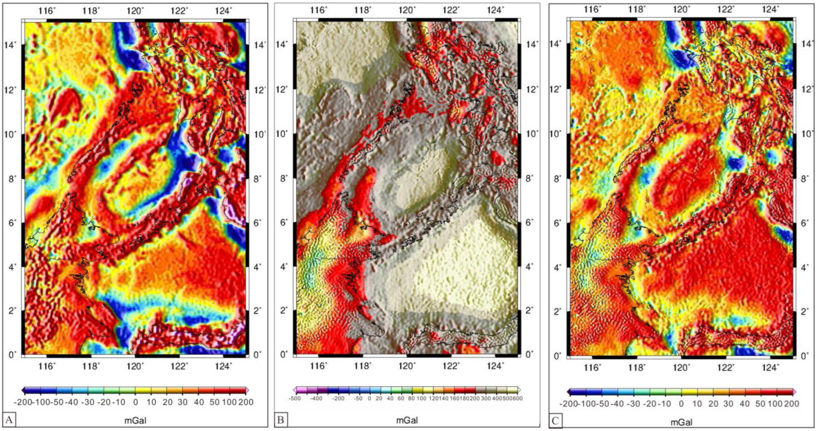
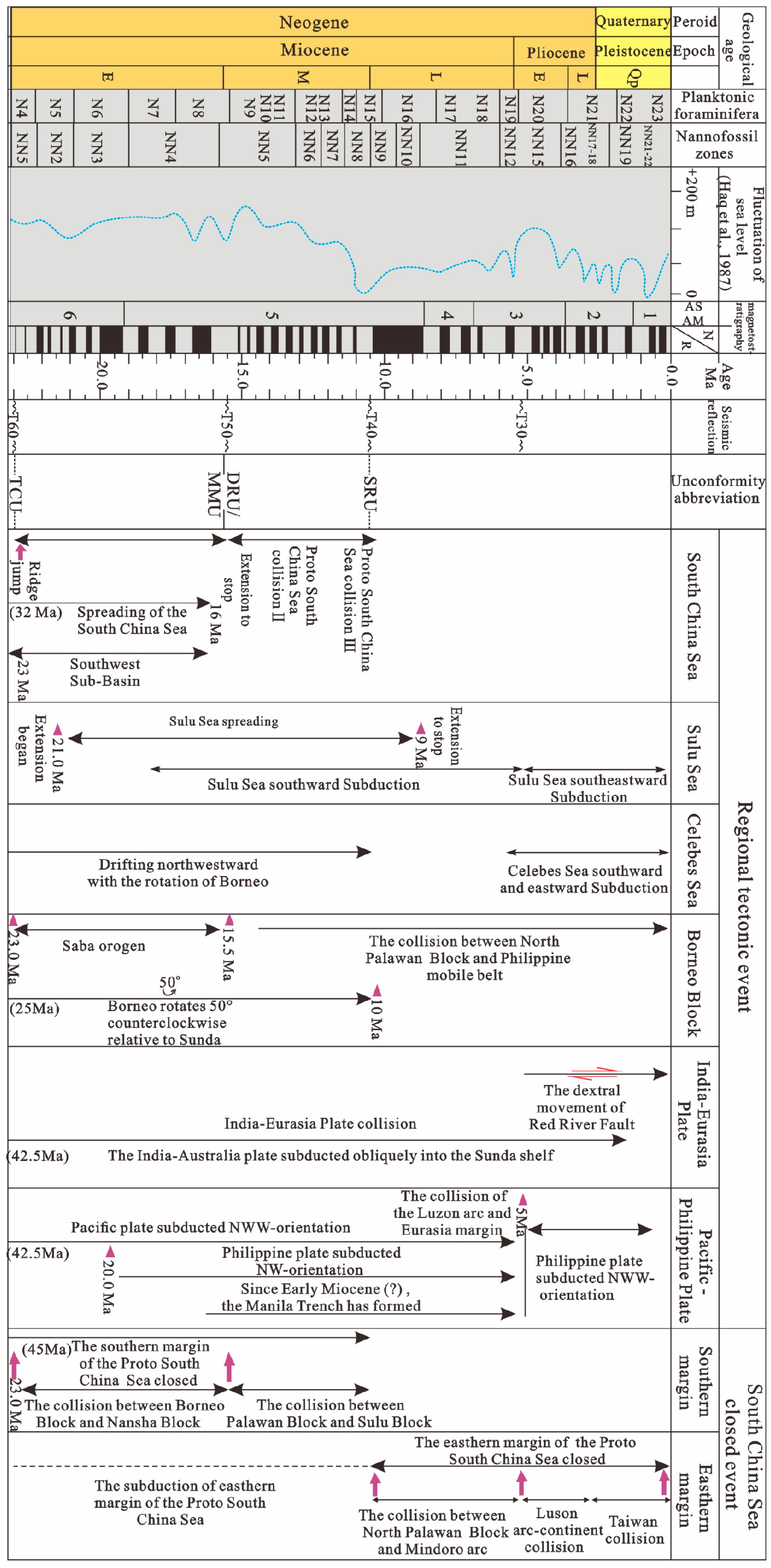
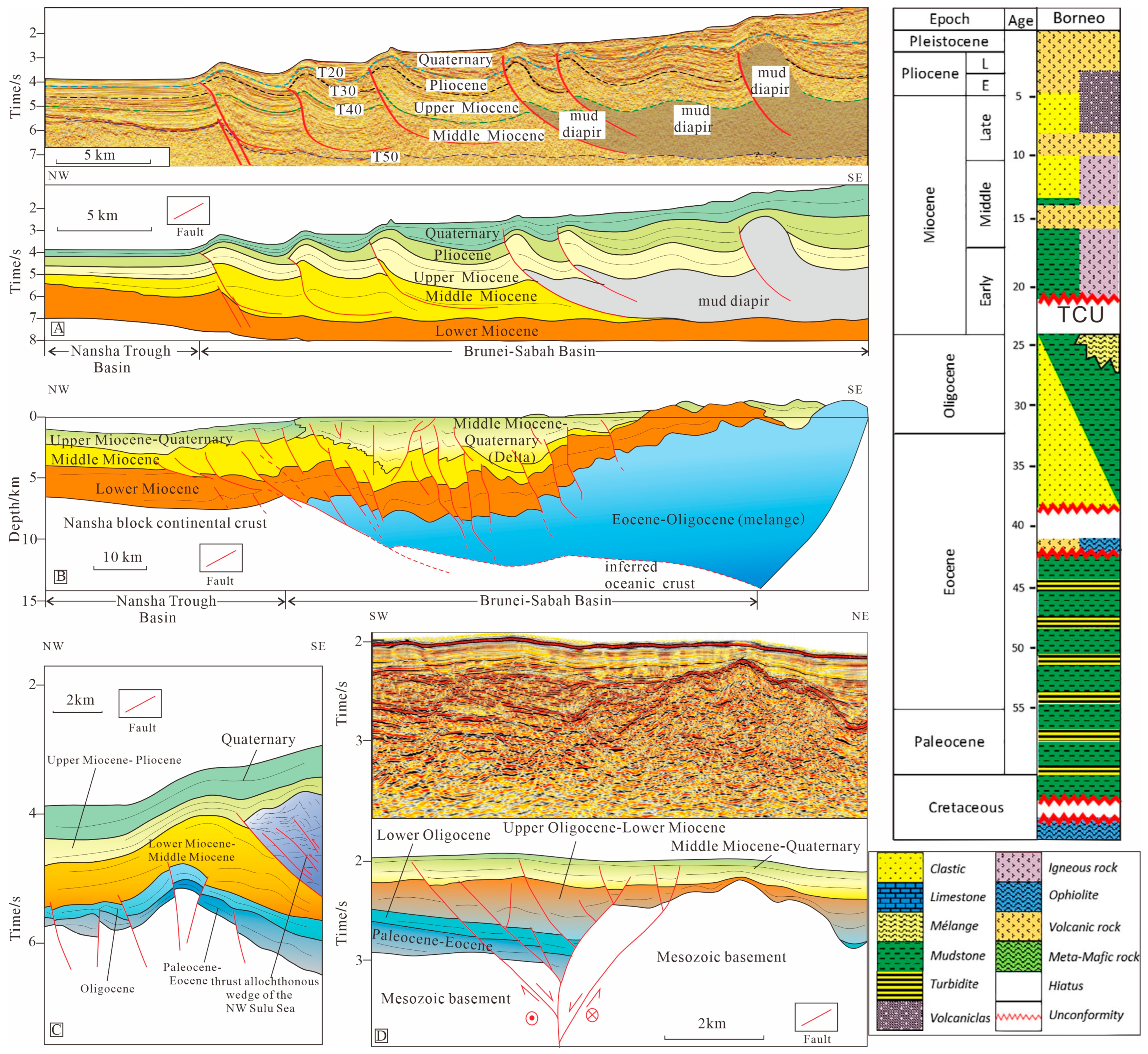
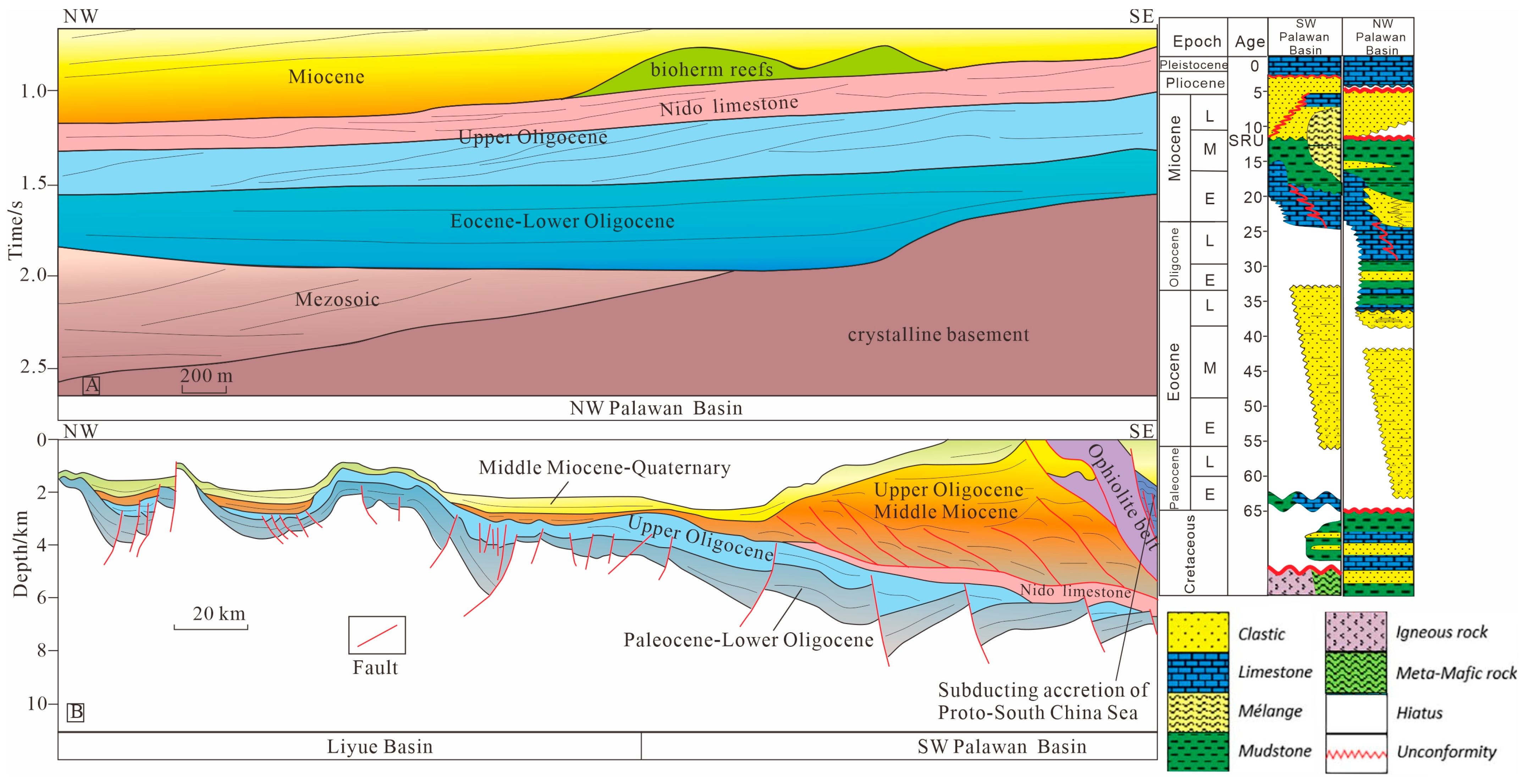
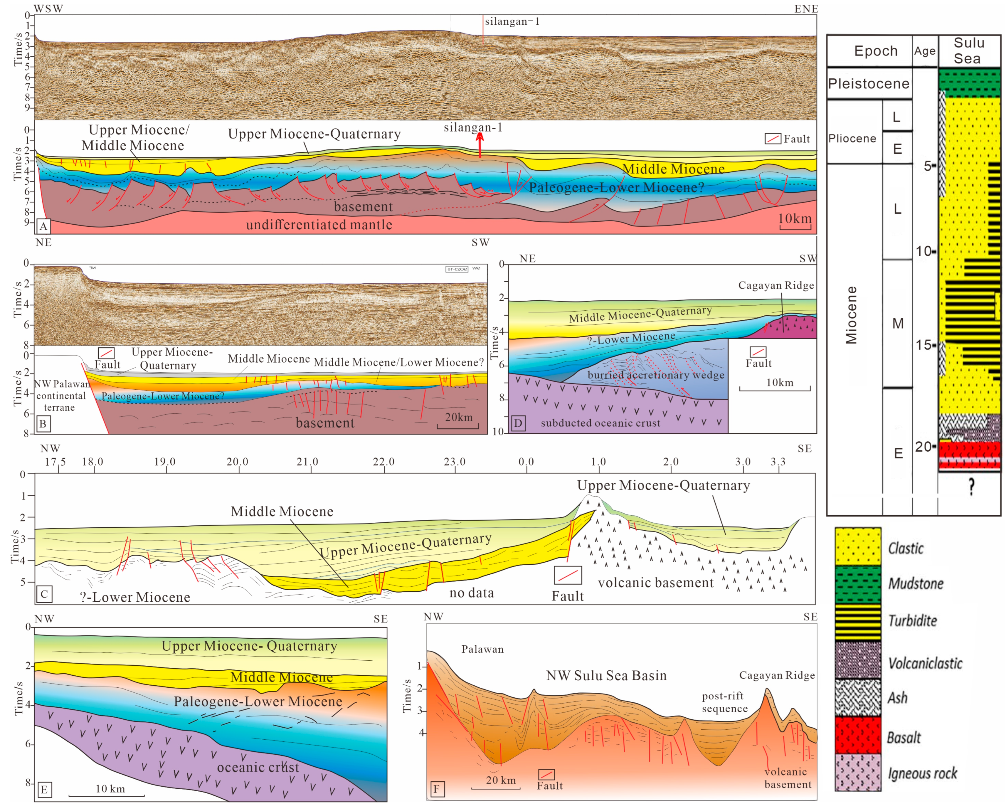
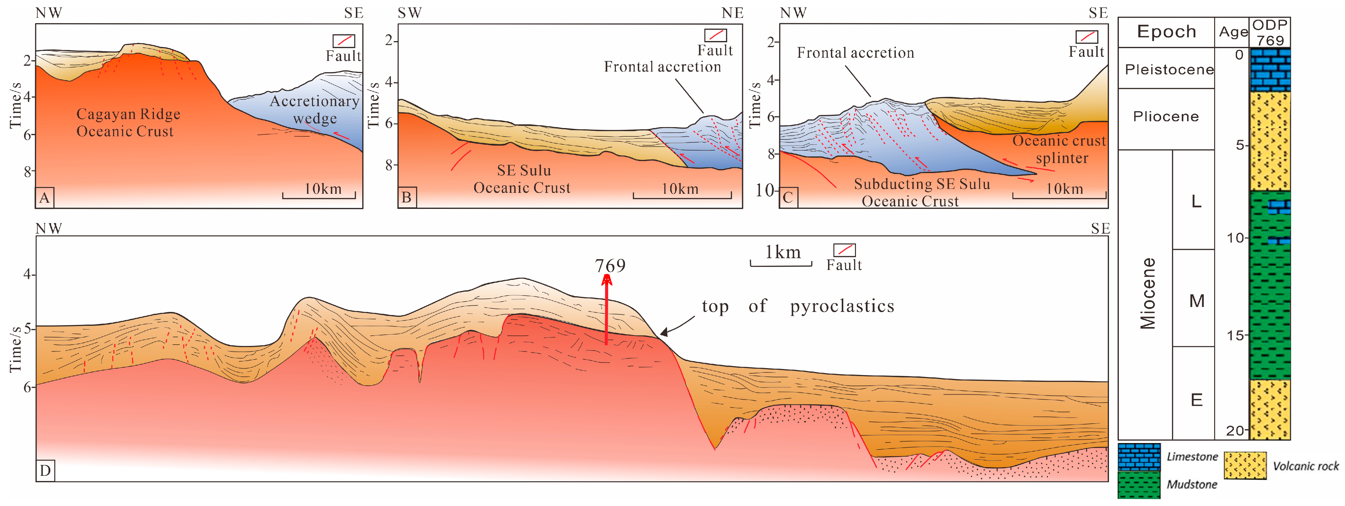
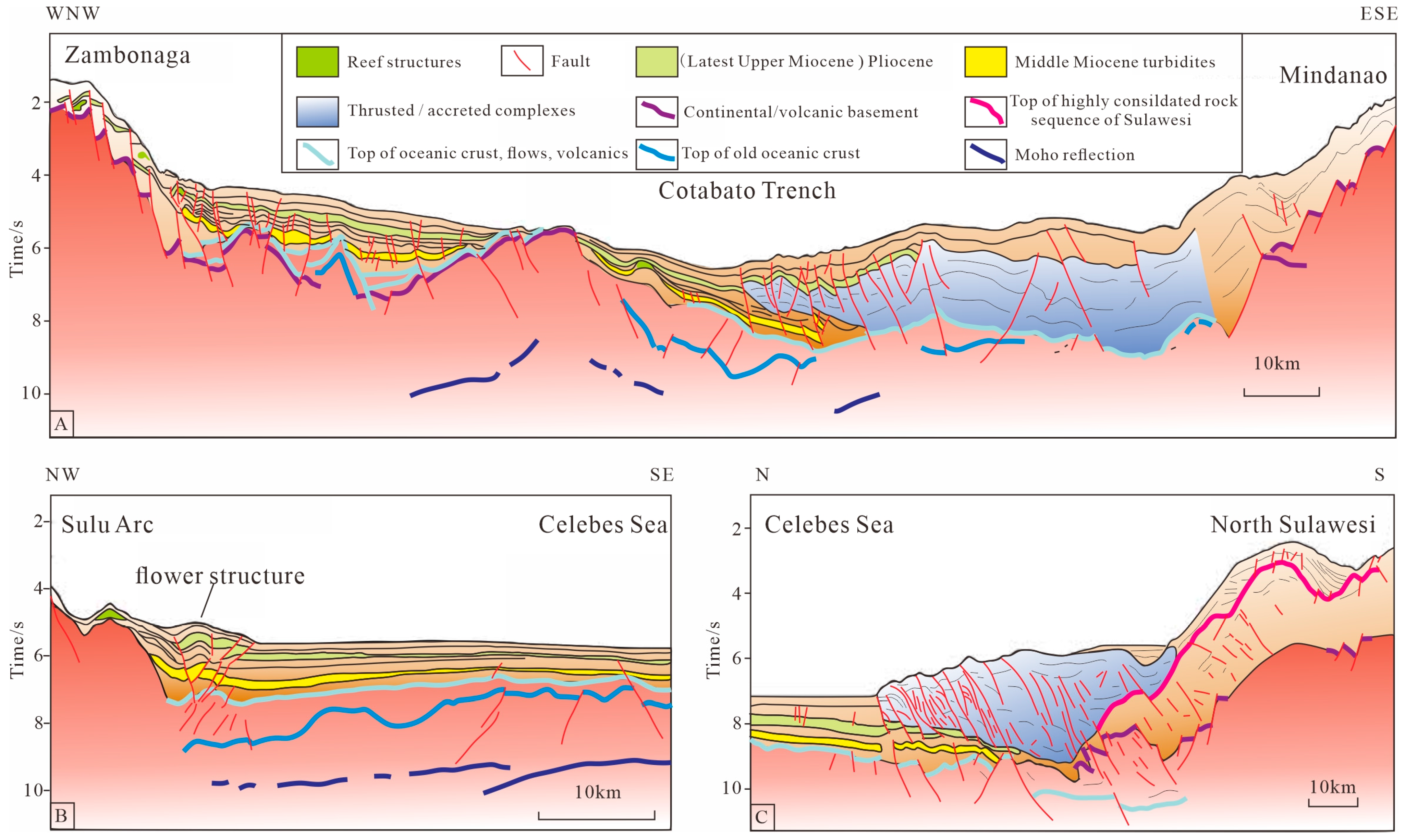
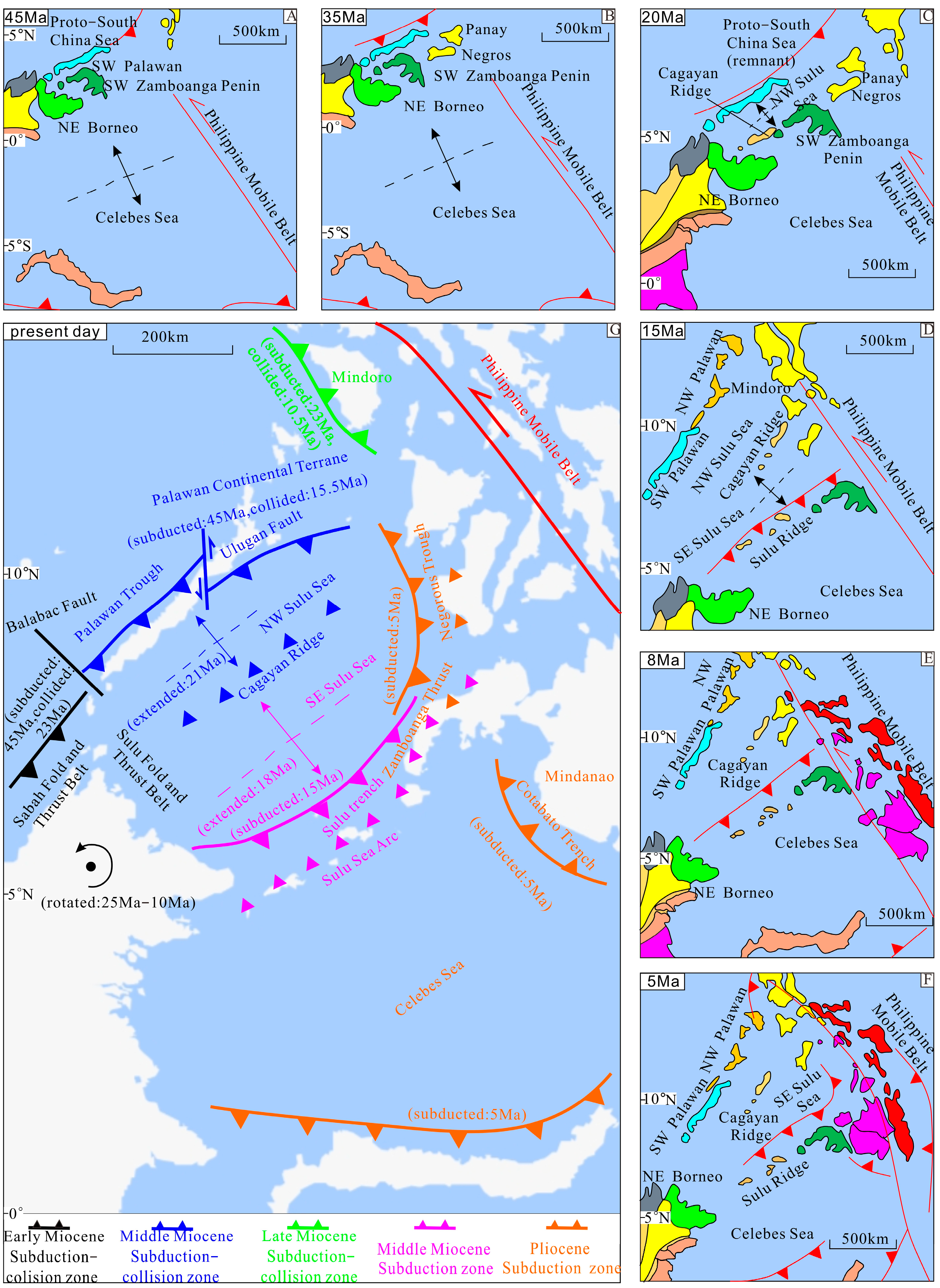
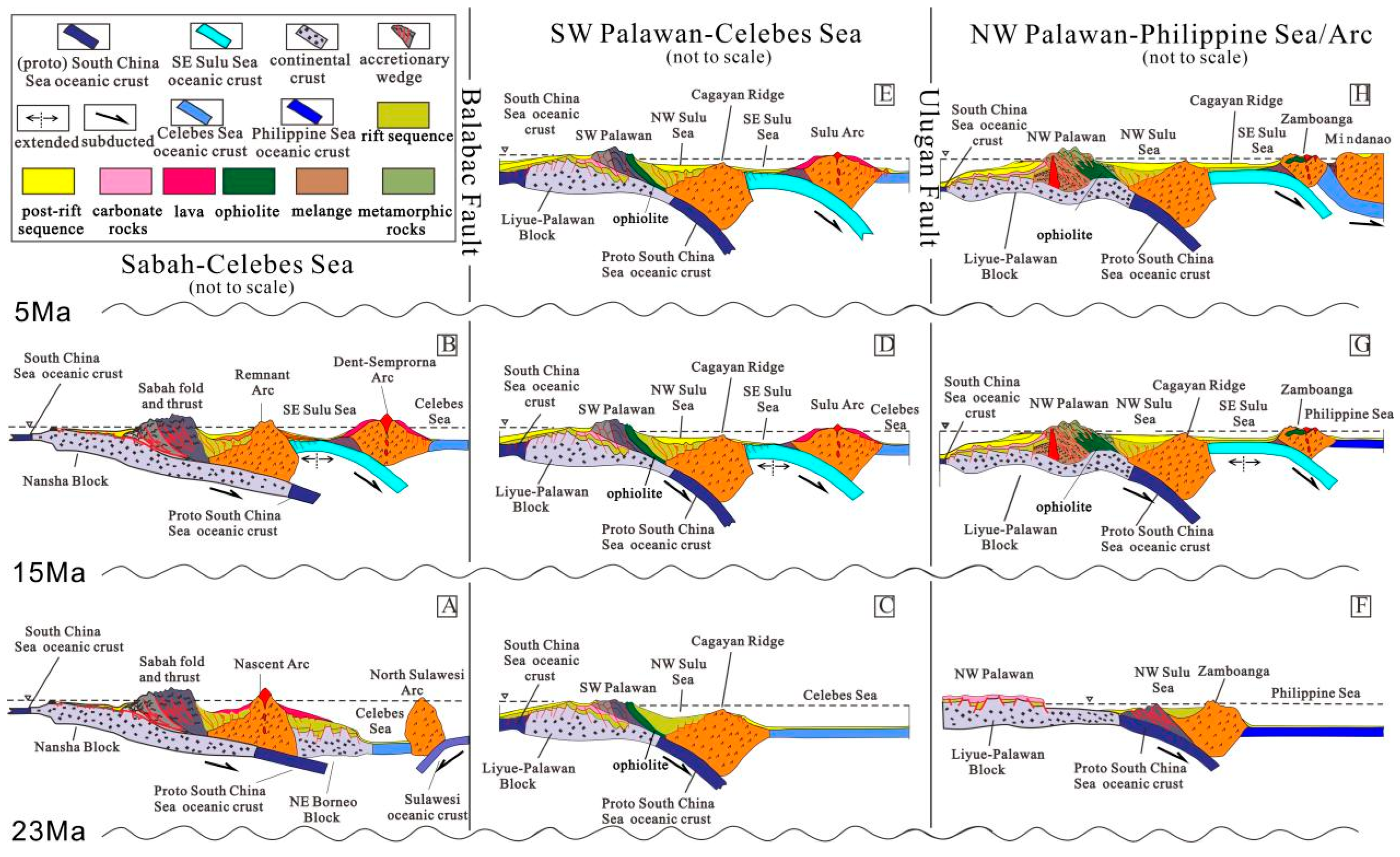
Disclaimer/Publisher’s Note: The statements, opinions and data contained in all publications are solely those of the individual author(s) and contributor(s) and not of MDPI and/or the editor(s). MDPI and/or the editor(s) disclaim responsibility for any injury to people or property resulting from any ideas, methods, instructions or products referred to in the content. |
© 2024 by the authors. Licensee MDPI, Basel, Switzerland. This article is an open access article distributed under the terms and conditions of the Creative Commons Attribution (CC BY) license (https://creativecommons.org/licenses/by/4.0/).