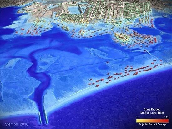
STORMTOOLS: Coastal Environmental Risk Index (CERI)
Abstract
:1. Introduction
2. Methods
2.1. Inundation and Waves
2.2. Structures and Infrastructure
2.3. Structure and Content Damage Functions
3. Results
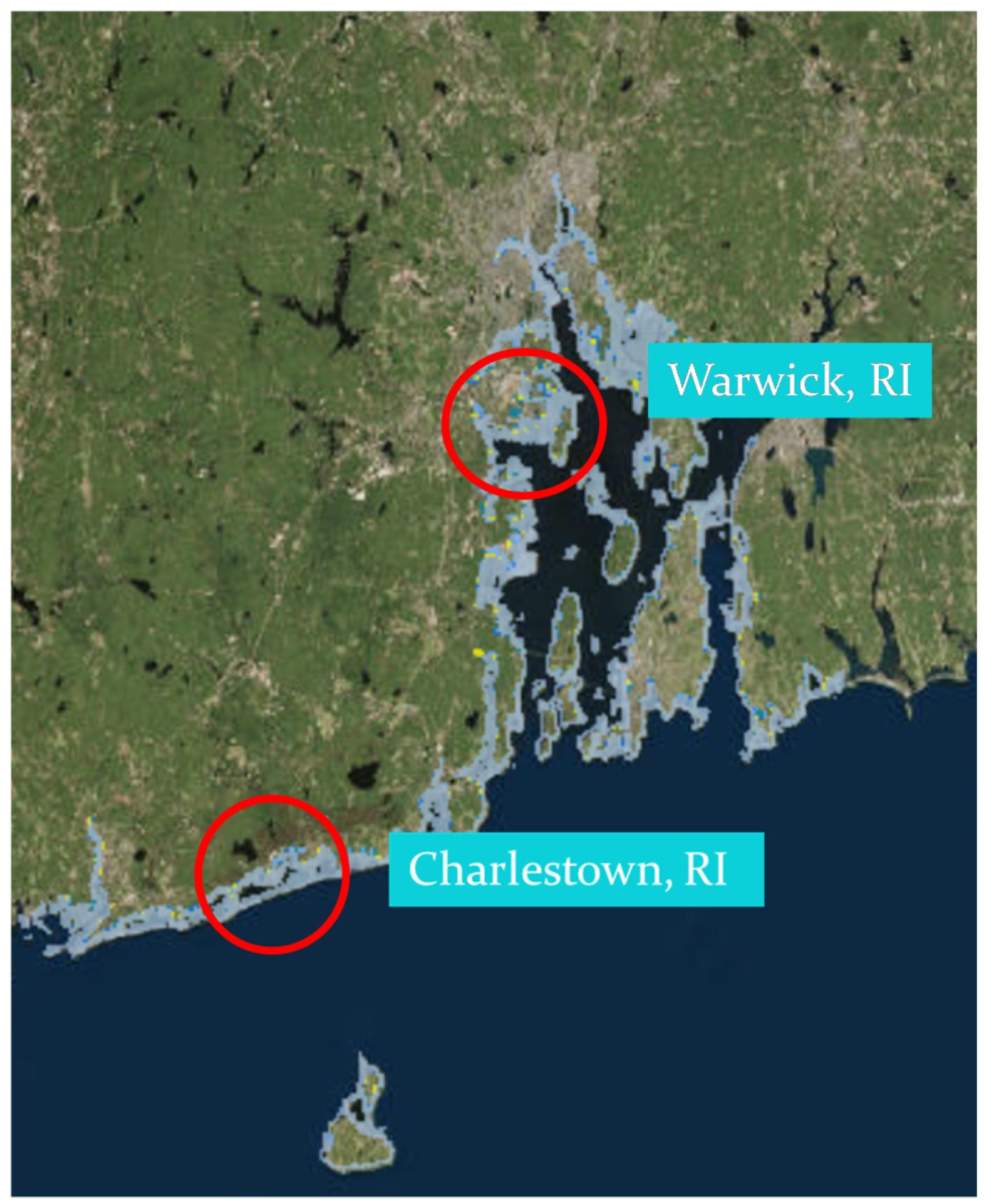
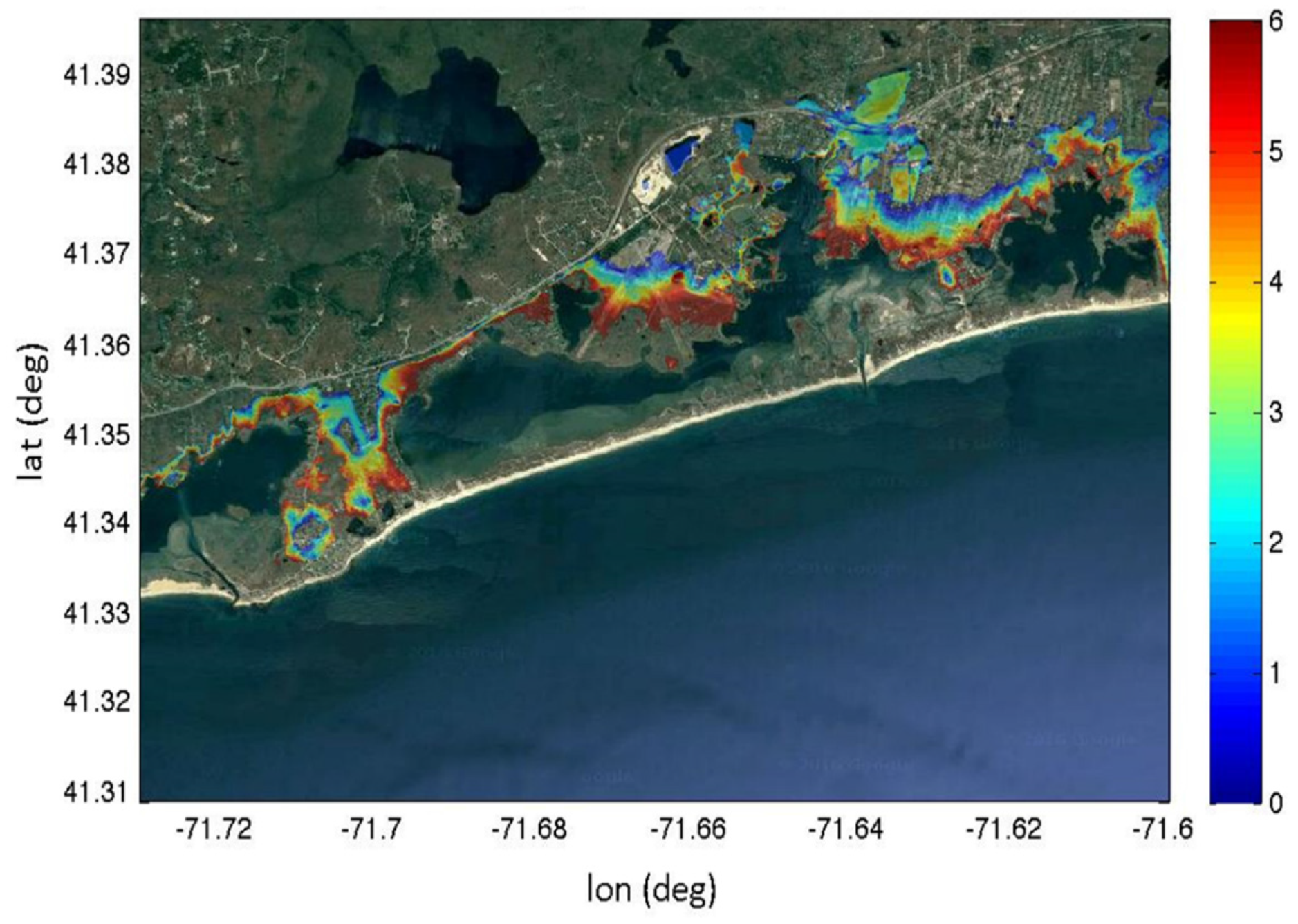
3.1. Application to Charlestown, RI
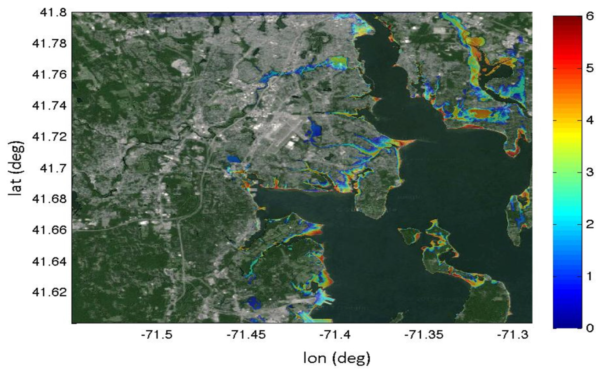
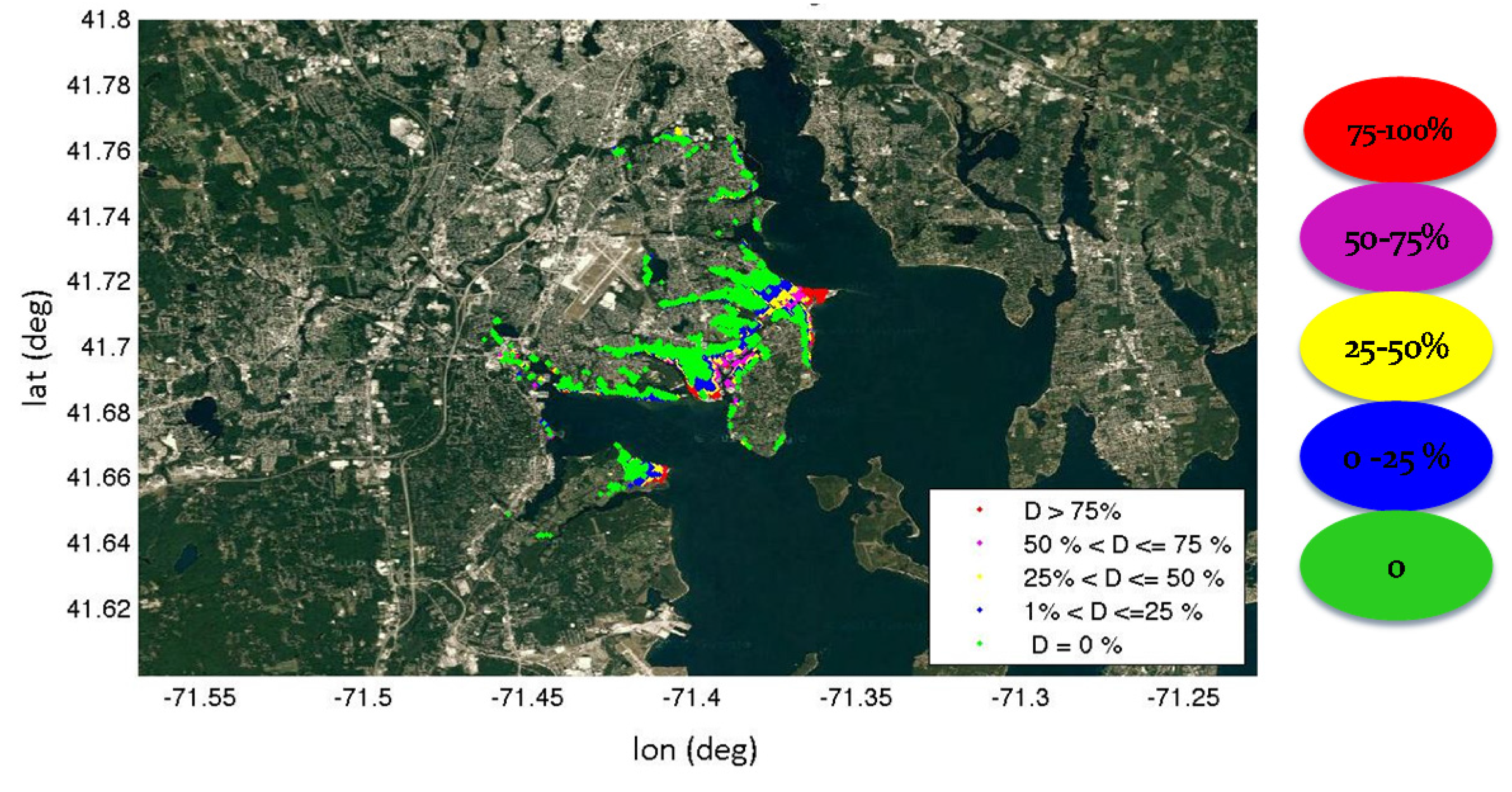
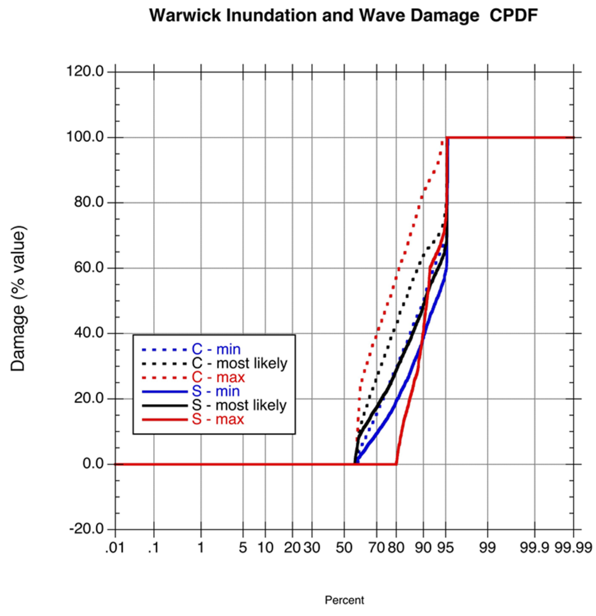
3.2. Application to Warwick, RI
3.3. Damages Structure by Structure
3.4. Visualizations of Damages
4. Conclusions
Acknowledgments
Author Contributions
Conflicts of Interest
Acronyms
| ACOE | Army Corp of Engineers |
| ADCIRC | ADvanced CIRCulation model |
| BFE | Base Flood Elevation |
| CERI | Coastal Environmental Risk Index |
| CRMC | RI Coastal Resources Management Council |
| DEM | Digital Elevation Model |
| FEMA | Federal Emergency Management Agency |
| HUD | Housing and Urban Development |
| LIDAR | Laser Imaging, Detection, and Ranging |
| NACCS | North Atlantic Comprehensive Coastal Study |
| NOAA | National Oceanic and Atmospheric Administration |
| OHCD | Office of Housing and Community Development |
| SAMP | Special Area Management Plan |
| SLOSH | Sea, Lake, and Overland Surges from Hurricanes |
| SLR | Sea Level Rise |
| STWAVE | STeady state spectral WAVE model |
| STORMTOOLS | tools in support of storm analysis |
| SWAN | Simulating Waves Nearshore |
| SWEL | Still Water Elevation |
Appendix A



References
- Jelesnianski, C.P.; Chen, J.; Shaffer, W.A. SLOSH: Sea, Lake, and Overland Surges from Hurricanes; NOAA Technical Report; US Department of Commerce, National Oceanic and Atmospheric Administration: Silver Spring, MD, USA, 1992; p. 71.
- Hammar-Klose, E.S.; Pendleton, E.A.; Thieler, E.R.; Williams, S.J. Coastal Vulnerability Assessment of Cape Cod National Seashore (CACO) to Sea-Level Rise. Available online: http://pubs.usgs.gov/of/2002/of02-233/USGS (accessed on 24 August 2016).
- Hapke, C.J.; Himmelstoss, E.A.; Kratzmann, M.G.; List, J.H.; Thieler, E.R. National Assessment of Shoreline Change: Historical Shoreline Change along the New England and Mid-Atlantic Coasts; US Geological Survey: Woods Hole, MA, USA, 2011.
- Federal Emergency Management Agency (FEMA). Atlantic Ocean and Gulf of Mexico Coastal Guidelines Update (FEMA, 2007). Available online: http://www.fema.gov/media-library-data/1388780453134-c5e577ea3d1da878b40e20b776804736/Atlantic+Ocean+and+Gulf+of+Mexico+Coastal+Guidelines+Update+(Feb+2007).pdf (accessed 24 August 2016).
- North Atlantic Coast Comprehensive Study: Resilient Adaptation to Increasing Risk. Available online: http://www.nad.usace.army.mil/Portals/40/docs/NACCS/10A_PhysicalDepthDmgFxSummary_26Jan2015.pdf (accessed on 24 August 2016).
- Federal Emergency Management Agency. HAZUS®MH MR3 Flood Model Technical Manual. Available online: https://www.fema.gov/media-library/assets/documents/12331 (accessed on 23 August 2016).
- Small, C.; Blanpied, T.; Kauffman, A.; O’Neil, C.; Proulx, N.; Rajacich, M.; Simpson, H.; White, J.; Baxter, C.; Spaulding, M.L.; et al. Assessment of damage from storm surge and sea level rise along Matunuck Beach Road and surrounding communities. J. Mar. Sci. Eng. 2016. in review. [Google Scholar]
- Cialone, M.A.; Massey, T.C.; Anderson, M.E.; Grzegorzewski, A.S.; Jensen, R.E.; Cialone, A.; Mark, D.J.; Pevey, K.C.; Gunkel, B.L.; McAlpin, T.O.; et al. North Atlantic Coast Comprehensive Study (NACCS) Coastal Storm Model Simulations: Waves and Water Levels. Available online: http://acwc.sdp.sirsi.net/client/enUS/search/asset/1045666 (accessed 24 August 2016).
- Spaulding, M.L.; Isaji, T.; Damon, C.; Fugate, G. Application of STORMTOOLS’s Simplified Flood Inundation Model, with and without Sea Level Rise, to RI Coastal Waters. In Proceedings of the ASCE Solutions to Coastal Disasters Conference, Boston, MA, USA, September 2015.
- Massey, T.C.; Anderson, M.E.; McKee-Smith, J.; Gomez, J.; Rusty, J. STWAVE: Steady-State Spectral Wave Model User’s Manual for STWAVE, Version 6.0; Environmental Research and Development Center, US Army Corp of Engineers: Vicksburg, MS, USA, 2011. [Google Scholar]
- Smith, J.M.; Sherlock, A.R.; Resio, D.T. STWAVE: Steady-State Spectral Wave Model, User’s Guide for STWAVE, Version 3.0; ERDC/CHL SR-01-01; U.S. Army Engineer Research and Development Center: Vicksburg, MS, USA; Available online: http://chl.wes.army.mil/research/wave/wavesprg/numeric/wtransformation/downld/erdc-chl-sr-01-11.pdf (accessed 24 August 2016).
- Oakley, B.A. Generalized 1% Storm Barrier Profile for the East Beach and Quonochontaug Barriers, Rhode Island; Technical Report Prepared for the Shoreline Change Special Area Management Plan (SAMP); University of Rhode Island: Narragansett, RI, USA, 2016. [Google Scholar]
- Boothroyd, J.C.; Hollis, R.J.; Oakley, B.A.; Henderson, R.E. Shoreline Change from 1939–2014, Washington County, Rhode Island; 1:2,000 scale. Rhode Island Geological Survey, 45 maps; University of Rhode Island: Narragansett, RI, USA, 2016. [Google Scholar]





| Number | Description |
|---|---|
| 1A-1 | One Story Apartment-No Basement |
| 1A-3 | Three Story Apartment-No Basement |
| 1B-1 | One Story Apartment-With Basement |
| 1B-3 | Three Story Apartment-With Basement |
| 2 | Commercial-Engineered |
| 3 | Commercial-Pre-non Engineered |
| 4A | Urban High Rise |
| 4B | Beach High Rise |
| 5A | Single Story Residence, No Basement |
| 5B | Two Story Residence, No Basement |
| 6A | Single Story Residence, With Basement |
| 6B | Two Story Residence, With Basement |
| 7A | Building with Open Pile Foundation |
| 7B | Building with Enclosed Pile Foundation |
| Most Likely Damage Curves | ||||||
|---|---|---|---|---|---|---|
| Structure | Number houses in SLR0 zone | Number houses in SLR7(2.1m) zone | Percent of total houses-SLR0 zone | Percent of total houses 2016-SLR7(2.1m) zone | Percent of total houses 2100-SLR7(2.1m) zone | |
| Prototype | Description Prototype | |||||
| 5A | 1 story/no basement | 244 | 290 | 24.4 | 33.1 | 21.9 |
| 6B | 2 story/basement | 682 | 585 | 68.1 | 66.9 | 44.2 |
| 7A | Open piles | 36 | 0 | 3.6 | 0.0 | 0.0 |
| 7B | Enclosed piles | 40 | 0 | 4.0 | 0.0 | 0.0 |
| Total structures | 1002 | 875 | 100.0 | 100.0 | 66.1 | |
| Total structures eroded by SLR | 49 | 3.7 | ||||
| Total structures under MSL | 399 | 30.2 | ||||
| Total structures, including eroded or under MSL in 2100 | 1323 | 100.0 | ||||
| Most Likely Damage Curves | |||||||
|---|---|---|---|---|---|---|---|
| 100-year storm (2016) Dunes intact | 100-year storm (2016) Dunes failed | 100-yr storm 2100-2.1 m SLR-Dunes failed | |||||
| Prototype | Description Prototype | Number | % of house | Number | % of house | Number | % of house |
| 5A | 1 story/no basement | 189 | 77.5 | 207 | 84.8 | 272 | 93.8 |
| 6B | 2 story/basement | 618 | 90.6 | 682 | 100.0 | 573 | 97.9 |
| 7A | Open piles | 27 | 75.0 | 36 | 100.0 | 0 | 0.0 |
| 7B | Enclosed piles | 35 | 87.5 | 40 | 100.0 | 0 | 0.0 |
| Total structures | 869 | 86.7 | 965 | 96.3 | 845 | 96.6 | |
| Total number of structures damaged greater than 50% | |||||||
| 100-year storm (2016) Dunes intact | 100-year storm (2016) Dunes failed | 100-year storm 2100-2.1 m SLR-Dunes failed | |||||
| Prototype | Description Prototype | Number | % of house | Number | % of house | Number | % of house |
| 5A | 1 story/no basement | 17 | 7.0 | 83 | 34.0 | 200 | 69.0 |
| 6B | 2 story/basement | 204 | 29.9 | 382 | 56.0 | 446 | 76.2 |
| 7A | Open piles | 0 | 0.0 | 36 | 100.0 | 0 | 0.0 |
| 7B | Enclosed piles | 0 | 0.0 | 40 | 100.0 | 0 | 0.0 |
| Total structures | 221 | 22.1 | 541 | 54.0 | 646 | 73.8 | |
| Most Likely Damage Curve | ||||||
|---|---|---|---|---|---|---|
| Structure | Number house SLR0 zone | Number houses in SLR7 zone | Percent of total houses-SLR0 zone | Percent of total houses-SLR7 zone | Percent of total houses 2016-SLR7 zone | |
| Prototype | Description Prototype | |||||
| 5B | 1 story/basement | 754 | 1879 | 30.1 | 37.1 | 35.4 |
| 6B | 2 story/basement | 1730 | 3180 | 69.1 | 62.8 | 60.0 |
| 7A | Open piles | 4 | 2 | 0.2 | 0.0 | 0.0 |
| 7B | Enclosed piles | 16 | 5 | 0.6 | 0.1 | 0.1 |
| Total | 2504 | 5066 | 100.0 | 100.0 | 95.5 | |
| Total structure under MSL | 238 | 4.5 | ||||
| Total structures, including eroded or under MSL in 2100 | 5304 | 100.0 | ||||
| Most Likely Damage Curves | ||||||
|---|---|---|---|---|---|---|
| Total Number of Structures Damaged | ||||||
| 100-year storm (2016) | 100-year storm 2100-2.1 m SLR | |||||
| Structure | ||||||
| Prototype | Description Prototype | Number | % of house | Number | % of house | |
| 5B | 1 story/basement | 685 | 90.8 | 1773 | 94.4 | |
| 6B | 2 story/basement | 1730 | 100.0 | 3112 | 97.9 | |
| 7A | Open piles | 4 | 100.0 | 2 | 100.0 | |
| 7B | Enclosed piles | 16 | 100.0 | 5 | 100.0 | |
| Total | 2435 | 97.2 | 4892 | 96.6 | ||
| Total Number of Structures Damaged Greater than 50% | ||||||
| 100-year storm (2016) | 100-year storm 2100-2.1 m SLR | |||||
| Structure | ||||||
| Prototype | Description Prototype | Number | % of house | Number | % of house | |
| 5B | 1 story/basement | 85 | 11.3 | 505 | 26.9 | |
| 6B | 2 story/basement | 404 | 23.4 | 1682 | 52.9 | |
| 7A | Open piles | 3 | 75.0 | 2 | 100.0 | |
| 7B | Enclosed piles | 13 | 81.3 | 3 | 60.0 | |
| Total | 505 | 20.2 | 2192 | 43.3 | ||
© 2016 by the authors; licensee MDPI, Basel, Switzerland. This article is an open access article distributed under the terms and conditions of the Creative Commons Attribution license ( http://creativecommons.org/licenses/by/4.0/).
Share and Cite
Spaulding, M.L.; Grilli, A.; Damon, C.; Crean, T.; Fugate, G.; Oakley, B.A.; Stempel, P. STORMTOOLS: Coastal Environmental Risk Index (CERI). J. Mar. Sci. Eng. 2016, 4, 54. https://doi.org/10.3390/jmse4030054
Spaulding ML, Grilli A, Damon C, Crean T, Fugate G, Oakley BA, Stempel P. STORMTOOLS: Coastal Environmental Risk Index (CERI). Journal of Marine Science and Engineering. 2016; 4(3):54. https://doi.org/10.3390/jmse4030054
Chicago/Turabian StyleSpaulding, Malcolm L., Annette Grilli, Chris Damon, Teresa Crean, Grover Fugate, Bryan A. Oakley, and Peter Stempel. 2016. "STORMTOOLS: Coastal Environmental Risk Index (CERI)" Journal of Marine Science and Engineering 4, no. 3: 54. https://doi.org/10.3390/jmse4030054
APA StyleSpaulding, M. L., Grilli, A., Damon, C., Crean, T., Fugate, G., Oakley, B. A., & Stempel, P. (2016). STORMTOOLS: Coastal Environmental Risk Index (CERI). Journal of Marine Science and Engineering, 4(3), 54. https://doi.org/10.3390/jmse4030054


