1. Introduction
Coastal lagoons are generally defined as shallow water bodies, separated from the sea by a barrier, and connected to the sea by one or more restricted inlets (channels, hydraulic structure) [
1,
2]. They occupy around 13% of the coastline worldwide and about 5% of the European coast, where they are particularly prevalent around the Mediterranean Sea [
3]. Mediterranean coastal lagoons are highly productive ecosystems and are considered to be the most valuable systems of the Mediterranean coastal area, with crucial ecological, historical, and socio-economical importance [
4,
5].
Coastal lagoons are complex systems that can exhibit strong temporal and spatial variations in water levels, flows, and salinities. These variations are the result of the interaction between freshwater and seawater inflows, rain, evaporation, and wind-driven forces, which vary over a wide range of time-scales. These interactions largely control the biogeochemical behavior of coastal lagoons, with consequences for (i) the ecological functioning of these systems [
6,
7,
8,
9,
10,
11] and for (ii) human activities, such as commercial fishing, aquaculture, recreation, and tourism [
4].
The freshwater inflow from the watershed and the temporary or permanent nature of the exchanges with the marine environment, in addition to the high evaporation rates in this area, give Mediterranean lagoon waters a variable salinity ranging from oligohaline to hyperhaline waters [
12]. Hypersalinity occurs in coastal lagoons that have limited connectivity with the sea and in which freshwater input is lower than the evaporation rate. Examples in the world include Lagao de Araruama in Brazil [
13], Laguna Madre in the USA [
7], the Caimanero-Huizache lagoon system in Mexico [
14], Mar Menor lagoon in Spain [
15], and Coorong lagoon in Australia [
16]. High salinities are particularly favored by the confined nature of some lagoons, especially for choked lagoons [
17].
Mediterranean coastal lagoons have been identified as hotspots of climate change and vulnerability to environmental and anthropogenic pressures [
18], which can deeply modify the ecological status of these transitional areas [
19]. In order to implement sustainable management practices of these lagoons, it is of primary importance to study their hydro-saline dynamics given their impact on their ecological functioning. It is in particular critical to understand the influence of climatic and anthropogenic stressors on these dynamics, considering all the short-, medium- and long-terms stakes. Due to the interannual variability of the Mediterranean climate, studying the hydro-saline dynamics of a Mediterranean coastal lagoon and its responses to different anthropogenic and climatic stressors implies acquiring data over several years or decades. Moreover, given the spatial variability often encountered in these lagoons in terms of water levels and salinity, it is necessary to implement monitoring programs providing the best possible spatial resolution. Due to temporal and spatial constraints, the sustainability of such monitoring programs over the long term is often conditioned by the implementation of measurement protocols that are simple and economically viable in terms of human resources necessary for their implementation, the purchasing and maintenance cost, as well as the lifespan of the equipment used. Long-term hydro-saline monitoring programs exist in several lagoons [
20,
21]. However, such programs on choked lagoons are rare [
22], due to several challenges. The significant evaporation and limited exchanges with the sea often result in the drying up of large surface areas within these lagoons, in addition to large areas displaying reduced water heights (i.e., <10 to 20 cm). Hence, under windy conditions, wave height can become equivalent to the height of the water column. These lagoons also exhibit very large variations in salinity, with the possible crystallization of salt in certain areas. The low water heights combined with high salinities complexify the implementation of certain types of conventional monitoring, such as the use of CTD (“Conductivity, Temperature, Depth”) probes, which may become emerged or exposed to salinity levels outside of their measuring range. Acquiring data to study the hydro-saline dynamics of this type of lagoon, therefore, requires finding a compromise between different types of monitoring.
Using the example of a shallow and choked Mediterranean coastal lagoon, namely the Vaccarès Lagoon System, this article illustrates how combining different types of monitoring programs, with diverse spatial and temporal resolutions, allows the study of hydro-saline variations and provides a first analysis on the influence of the various anthropogenic and climatic stressors.
The paper is organized as follows:
Section 2 presents the study area, the data, and the methodology used to assess the hydro-saline dynamics of the Vaccarès Lagoon System in terms of water level, salinity, and mass of dissolved salt.
Section 3 outlines the results of these different measurements, and their contribution to the understanding of the hydro-saline dynamics of this lagoon, as well as the influence of various anthropogenic and climatic factors.
Section 4 takes advantage of the results to provide recommendations, as to the implementation of field measurements on this type of lagoon to characterize its hydro-saline dynamics. Results are also exploited to derive recommendations for the sustainable management of this type of environment on different time scales.
2. Materials and Methods
2.1. Study Area
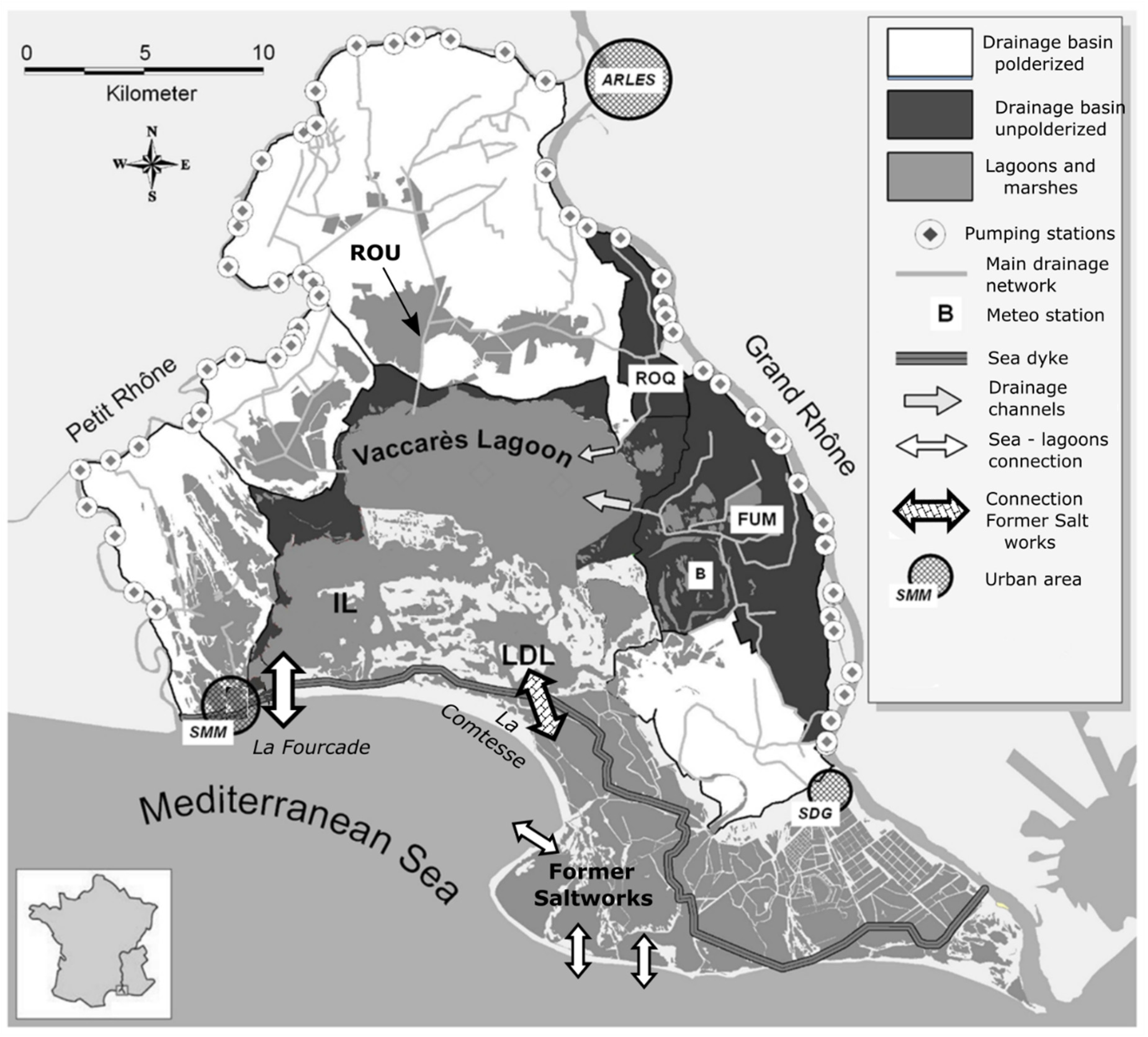
The Ile de Camargue basin is the central part of the Rhône Delta in the South of France, situated between the two branches of the Rhône River (see
Figure 1). The high-lying parts of this 800 km
2 area are devoted to agriculture (420 km
2) consisting mainly of rice fields, whereas wetlands, brackish lagoons, and marshes occupy the low-lying areas [
23]. The aquatic ecosystem in the center of this area is internationally recognized as a biosphere reserve as part of UNESCO’s Man and Biosphere Programme, and as a Ramsar site. It is of international significance for nesting, staging, and wintering waterbirds [
24]. This ecosystem includes three interconnected lagoons, which form the Vaccarès Lagoon System. These interconnected lagoons consist of the Vaccarès lagoon (65.9 km
2, average 1999–2019 salinity 16 PSU), the Impériaux lagoon (IL on
Figure 1; 36 km
2, average 1999–2019 salinity 33 PSU), and the Lion/Dame lagoon complex (LDL on
Figure 1; 8.3 km
2, average 1999–2019 salinity 25 PSU).
The Vaccarès Lagoon System is separated from the Mediterranean Sea by a dyke (
Figure 1). Direct exchange with the Mediterranean Sea only occurs in the Impériaux lagoon (IL), through a hydraulic structure at La Fourcade, which consists of 13 manually operated sluice gates of relatively moderate size (individual widths ranging from 1 to 1.2 m). The management of these gates is complex, involving a range of different stakes, in particular fish recruitment, storm surge management, and salinity. Throughout the year, a specific water management commission meets about every 2 months to define the sluice gates’ management rules to be applied according to current hydro-saline conditions in the lagoons. This commission is composed of representatives of the state, managers of the different lagoons pertaining to the Vaccarès Lagoon System, and a range of users (professional fishermen, farmers, ...). To give an order of magnitude, averages calculated from 2010 to 2020 indicate that all sluice gates are closed for about 40% of the year (147 days), up to two sluice gates are opened about 28% of the year (101 days), and at least three sluice gates are opened for about 32% of the year (117 days). Over the 1999–2007 period, the “sea to lagoons” daily average volume is about 39,000 m
3·day
−1, and the “lagoons to sea” daily average volume is about 48,000 m
3·day
−1.
Although the seashore of the Rhône Delta is subject to a micro-tidal regime (the difference between the lowest and highest value of astronomic tide is 0.42 m, see [
25]), the “Vaccarès lagoon system” is not impacted by a tidal regime, [
26], due to the small size of the sluice gates in comparison with the area of the Vaccarès Lagoon System, and to their management, with the opening of more than five sluices carried out to decrease water level and mass of salt into the lagoons (flows from the lagoons into the sea).
The Lion/Dame lagoon can exchange water with another complex of lagoons, “the Former Saltworks” [
27], through a hydraulic structure at La Comtesse (
Figure 1), which consists of eight manual sluice gates of relatively moderate size (individual width of 1.5 m). Prior to July 2010, all the sluice gates of this structure were permanently maintained closed. Since July 2010, one sluice gate has generally been open, except during storm surges when it is closed. “The Former Saltworks” are composed of several lagoons, most of which are connected to each other by hydraulic structures. Several openings (locally known as “
graus”) into the Mediterranean Sea exist in the southernmost parts of the Former Saltworks (
Figure 1). Hence, under certain conditions (opening of all the hydraulic works of the Saltworks and entry of sea water in their southernmost part), indirect exchanges between the Lion/Dame lagoon and the sea can occur.
Agricultural land borders the lagoons to the north and southeast, and is mostly devoted to intensive flooded rice cultivation. The rice fields are irrigated by pumping stations located on both arms of the Rhône River during the cropping season (from mid-April/early May, to mid-September/early October). In the unpolderized agricultural area (112 km
2) in the northeastern part of the Ile de Camargue and around the Vaccarès lagoon, the runoff from the rice paddies is discharged directly into the lagoon system through two drainage channels (Fumemorte (FUM) and Roquemaure (ROQ), see
Figure 1). Over the 1999–2007 period, the daily average volume discharged into the Vaccarès lagoon via the Fumemorte channel was about 115,000 m
3·day
−1. In contrast, in the northern and southeastern parts, the runoff from 310 km
2 of polderized rice paddies is pumped back to the Rhône River or to the Mediterranean Sea. Occasionally, a portion of the runoff from the polderized rice paddies can be discharged directly into the lagoon system through the Rousty channel (ROU), see
Figure 1.
Water management in the Vaccarès Lagoon System is very complex, involving many stakeholders whose interests can diverge. The main objectives of the management implemented are the following: With regard to salt dynamics, management practices aim to avoid a sustained increase in the total mass of dissolved salt in the lagoons, seeking to remain around a threshold value. Regarding water levels, management aims to both (i) prevent water levels from being too high to prevent flooding of surrounding areas and erosion of the lagoon banks, as well as to facilitate agricultural drainage, and (ii) prevent water levels from being too low (and salinities too high) to allow fishing activities to carry on in the lagoons. Finally, the management implemented seeks to carry on having a variability of water levels and salinities typical of Mediterranean wetlands, particularly in response to rainfall and evaporation. Due to variations in rainfall and evaporation from year to year, typical of the Mediterranean climate, to the shallow depths of the Vaccarès Lagoon System, and to the complexity of its hydro-saline functioning, some management objectives may not be met in certain years, creating regular tensions around water management in this area, which is still subject to debate.
2.2. Hydro-Saline Dynamic Assessment
The hydro-saline dynamic of the Vaccarès Lagoon System was investigated through the spatial and temporal variations of: (i) water level, (ii) salinity, and (iii) total mass of dissolved salt in the different lagoons of this system.
The total mass of dissolved salt was included in the variables studied for several reasons. It is a quantity that will increase or decrease depending on the exchange of water between the lagoon and the sea, and, for some lagoons, also depending on underground flows. Evaporation and precipitation will not directly change this mass. Conversely, for a given mass of salt in a lagoon, the salinities measured in a particular year will be strongly linked to evaporation and rainfall observed in that year, as well as to the water inlets of the lagoon’s channels or rivers. The mass of dissolved salt and salinity then provides complementary information when dealing with the saline dynamic assessment of Mediterranean coastal lagoons.
The mass of dissolved salt gives information on the medium and long-term evolution of the salt dynamics, and on the dynamics of the exchanges with the sea. The knowledge of the evolution of this mass also allows, in the case where the exchanges between the lagoon and the sea are managed by man, to study the consequences of management choices on the saline dynamics of these lagoons. The knowledge of the evolution of salinity, more easily measurable than the mass of dissolved salt because it does not require the knowledge of the volumes in the lagoon, will allow to bring elements on the spatial saline dynamics of lagoons. In addition, there are usually no known relationships between the tolerance of animal (fish) or plant species to the mass of dissolved salt, while these relationships are often known for salinity, whether in terms of average value or tolerance threshold.
Knowledge of the evolution of both the mass of dissolved salt and salinities also provides information on the parameters that influence the lagoons’ saline dynamics. For example, if a lagoon shows changes in salinity over several years, while the mass of dissolved salt varies little, the explanations will be sought in the dynamics of rainfall and evaporation, or unsalted water inflows from channels or rivers connected to the lagoon. On the other hand, if the mass of dissolved salt also varies over the period considered, the observed variations in salinity will surely be partly linked to the modification of exchanges with the sea or groundwater.
Water level, salinity, and total mass of dissolved salt in the different lagoons were either obtained directly from field measurements or calculated from these measurements. The different datasets and calculation methods used for their estimate are detailed below.
2.2.1. Water Level and Salinity Variations in the Lagoons
Regarding water level and salinity in the different lagoons, several datasets with different spatial and temporal resolutions were used:
- (i)
Salinity measured monthly from 1999 to 2019 at locations 1 to 11 (see
Figure 2). For these field campaigns, conductivity was measured with a WTW TetraCon 325 conductivity meter about 20 cm below the water surface and converted to salinity using the international oceanographic table [
28]. For conductivities exceeding 60,000 µS/cm, one or several successive dilutions were performed with distilled water to fall within the validity range of the equation to derive salinity from conductivity.
- (ii)
Data from field instruments recording every 5–15 min and averaged on an hourly basis between 1999 and 2019 at three locations close to the connections with: (i) the Sea (location 12,
Figure 2), (ii) “the Former Saltworks” (location 15,
Figure 2) and (iii) the Fumemorte drainage channel (location 14,
Figure 2). During this period, water levels were monitored using float-operated Thalimedes Shaft Encoders with integral data logger from OTT Hydrometry, with the exception of location 12 where an OTT Hydrometry R 20 scrolling paper water level gauge was used for 1999 and 2000.
- (iii)
Water level and salinity data recorded by CTD probes from OTT Hydrometry recording every 5–15 min and averaged on an hourly basis between 2017 and 2019 (with the exception of several periods of non-operation due to either water levels being too low for the conductivity sensor to remain immersed, salinity values being outside the instruments’ range, or instrumental problems such as clogging of the probe or internal battery problems), at five locations in the lagoons (locations 18, 19, 20, 21, and 22,
Figure 2). Another CTD probe was installed in 2019 in one sluice gate of the Comtesse hydraulic structure to measure the salinity of the corresponding flow (location 17,
Figure 2). All CTD probes were located about 10 cm above the bottom of the lagoons or of the sluice gate.
2.2.2. Total Volume and Dissolved Salt Mass Variations
To evaluate the total volume of water in the lagoons from the water levels, we generated a Digital Elevation Model (DEM) of the Vaccarès Lagoon System using the existing bathymetric data.
The bathymetric data was obtained from successive field campaigns between 1999 and 2013 conducted on the different lagoons, and completed in 2010 by one terrestrial LiDAR campaign for the outer edges of the lagoons and the inner islands. The total number of measured points was approximately 14,500. The 10 m resolution DEM (
Figure 3) was obtained by interpolating between individual measurements using a TIN interpolation (ArcGIS 10.4 raster interpolation tool, from ESRI).
The total volume of water in the lagoons
(in m
3) was calculated for the period 1999–2019 with Equation (1):
with:
- -
the total number of cells of the DEM;
- -
the mean water level in the Vaccarès Lagoon System, which is the average value of the water levels measured at the locations 12, 14, and 15 (see
Figure 2);
- -
the interpolated bathymetry of cell number i; and
- -
the area of cell number i.
The total mass of dissolved salt in the Vaccares Lagoon System
(in kg) was calculated with Equation (2):
with
the salinity of cell number
i.
For each cell of the DEM, the local salinity
was obtained by using the Spline with barrier interpolation tool (ArcGIS 10.4) between the monthly salinity measurements (see
Figure 2).
2.2.3. Water Fluxes between the Vaccarès Lagoon System and (i) the Mediterranean Sea, (ii) “the Former Saltworks”
To study the influence of “Sea-lagoon” and “Former Saltworks-lagoon” exchanges on the hydro-saline dynamics, and knowing that in the management implemented, each sluice gate is either totally closed or totally open, we estimated the hourly volumes of water exchanged through the hydraulic structures at La Fourcade and La Comtesse, with the flow Equation (3) (originally presented in [
6]) and Equation (4):
when the sluice gate is totally open.
with:
- -
the flow of the sluice gate i (m3·s−1);
- -
the width of the sluice number i (m);
- -
the upstream water height above the sill of the sluice gate i (m);
- -
the downstream water height above the sill of the sluice gate i (m); and
- -
the discharge coefficient of the sluice number i (−). Values of the different were determined for the Fourcade and Comtesse structures with flow measurement campaigns, using an electromagnetic digital current meter (NAUTILUS C 2000, from OTT Hydrometry).
- -
is the total flow estimated for the 13 sluice gates (m3·s−1),
Water Level and Sluice Gates Opening Data for the Fourcade Structure
For H and H’, we used for the sea level data the measurements obtained from two probes successively located in the Sea near the structure (location 13,
Figure 2). The first probe was a OTT Hydrometry R 20 scrolling paper water level gauge, with measurements in 1999 and 2000. The second probe was a float-operated Thalimedes Shaft Encoders with integral data logger from OTT Hydrometry, with measurements every 5 min from 2001 to 2019. Water level data in the lagoons are those recorded by the probes at location 12, see
Section 2.2.1.
Opening data of the 13 sluices gates of the Fourcade structure were provided by the technical services of the town of Saintes-Maries de la Mer (SMM in
Figure 1), in charge of their management.
These data were used to calculate the hourly discharge through the hydraulic structures at La Fourcade with Equations (3) and (4).
Water Level and Sluice Gates Opening Data for the Comtesse Structure
For H and H’, we used for the water level data in the southern part of the Comtesse structure the measurements obtained from the probe in location 16 (
Figure 2), located about 1 m from the structure. The probe was a float-operated Thalimedes Shaft Encoder with integral data logger from OTT Hydrometry, with measurements in 2019 every 15 min and averaged on an hourly basis. Water level data in the lagoons are those recorded by the probes at location 15, see
Section 2.2.1.
Opening data of the sluice gates of the Comtesse structure were provided by the National Society for Nature Protection (SNPN), in charge of their management.
These data were used to calculate the hourly discharge through the hydraulic structures at La Comtesse with Equations (3) and (4).
2.2.4. Water Fluxes between the Vaccarès Lagoon System and the Agricultural Drainage Channels
Water flows from the Fumemorte drainage channel into the Vaccarès lagoon were monitored every 30 min from 1999 to 2007 using an automatic ultrasonic flowmeter “UF 2100 CO” from Ultraflux. For the Roquemaure channel, no equivalent measuring device was installed during this period. However, [
29,
30] estimated that the flow of this channel was no more than 20% of that of the Fumemorte.
In this study, the Fumemorte channel, which is the main contributor to the entrance of drainage water in the lagoons, was then considered to be representative of the influence of drainage water on the hydro-saline dynamics of the lagoons.
2.2.5. Evaporation and Rainfall
During the period from 1999 to 2019, wind (speed and direction), air temperature, precipitation, solar irradiance, relative humidity, and duration of insolation were measured continuously at station B operated by Meteo France (see
Figure 1). All these variables were measured on an hourly basis.
Daily evaporation intensity was derived from these measurements using the Penman method [
31]. Daily evaporated volumes were then estimated from the daily evaporation intensity and the water-covered surface area on the corresponding day. This water-covered surface area was estimated using the average water level measured with probes at locations 12, 14, and 15 (
Figure 2), and the DEM developed in this study.
2.2.6. Estimation of the Order of Magnitude of All Unmonitored Water Inputs and Outputs
To estimate an order of magnitude of the “unknown” water inflows and outflows of the system, we computed a volume balance. In the case of the Vaccarès Lagoon System, these unquantified volumes, referred as “Other” in the paper, include:
- -
agricultural drainage inflows through the Roquemaure and Rousty channels (“ROQ” and “ROU” in
Figure 1);
- -
seasonal and short-lived agricultural drainage inflows from private estates, located mainly around the Vaccarès lagoon and west of the Impériaux (in dark gray in
Figure 1);
- -
rainfall runoff from areas along the Vaccarès, Impériaux, and Lion/Dame lagoons;
- -
seasonal and short-lived drainage of surrounding marshes into the lagoons; and
- -
exchanges of groundwater and surface water.
These volumes were estimated with Equation (5). This estimate was carried out on several periods of the years 1999–2007, for which we had the most data available. Since some of the physical quantities considered were only available on a daily time scale (evaporation), the terms in Equation (5) were computed on a daily basis.
With:
- -
N the duration of the considered period in days (typically a year),
- -
(m3): the cumulative volumes, over the N days, that are not due to precipitation, evaporation, sea-lagoon exchanges, and Fumemorte inflows.
- -
(m3): the change in volume in the Vaccarès Lagoon System between the beginning and the end of the period of N days, calculated as the difference between the volume at the end and at the beginning of the period. To limit the uncertainty in its estimation, we chose periods beginning and ending on days when the water levels at locations 12, 14, and 15 were nearly equal (often corresponding to windless days). This allowed to limit the uncertainties on the estimation of the average water level in the Vaccarès from these three measurements, and consequently on the estimation of the corresponding volume. As much as possible, we have chosen beginning and ending dates allowing to cover a period close to one year
- -
(m3): the cumulative volumes of rain over the N days,
- -
(m3): the cumulative volumes of evaporation over the N days,
- -
(m3): the cumulative volumes from the sea into the lagoons over the N days
- -
(m3): the cumulative volumes from the lagoons into the sea over the N days, and
- -
(m3): the cumulative volumes from the Fumemorte channel over the N days.
4. Discussion
The Vaccarès Lagoon System is a Mediterranean coastal lagoon that illustrates well the importance of implementing different monitoring strategies to understand the hydro-saline functioning of choked lagoons. These strategies differ whether (i) short-term (e.g., “What water management should be implemented immediately to make fishing possible this year?”) or (ii) long-term (e.g., “Will future hydro-saline conditions not be permanently altered by current water management?”) stakes are considered. They relate to the spatial and temporal distribution of sampling, as well as the parameters considered to characterize the hydro-saline dynamics of these environments (salinity vs. mass of dissolved salt, etc.).
Depending on the nature (hydraulic works, natural connection) and the characteristics of their connections with the sea, their watersheds or surrounding rivers, shallow coastal lagoons can exhibit very significant spatial and temporal heterogeneity in both salinity and water level. The Vaccarès Lagoon System illustrates perfectly the complexity of monitoring the hydro-saline dynamics for such lagoons, and in particular for those that can be classified as choked. Due to its narrow connection to the sea, its shallow depth and extensive surface area resulting in large volumes of evaporated water, the Vaccarès Lagoon System presents large areas displaying reduced water heights (i.e., <10 to 20 cm) and can exhibit very high salinity with salt crystallization in areas drying out. The low water height combined with high salinity complexify the implementation of certain types of conventional monitoring, such as the use of CTD probes, which may become emerged or exposed to salinity levels outside of their measuring range. Hence, considering the large area of the Vaccarès Lagoon System and its great spatial heterogeneity, the implementation of a spatially representative continuous monitoring program using CTD probes over several decades would require a considerable effort in terms of human and financial resources. Moreover, it would present a high probability of having data gaps at some monitoring sites due to the low water height and high salinity over months presenting the highest evaporation rate. An approach consisting of monthly in situ field measurements, more perennial and more easily implemented, seems to be relevant for the long-term monitoring of the dynamics of this type of environment. However, our work shows that monthly measurements failed to detect salinity variations over short periods of time. Hence, this type of measurement, although allowing to follow the hydro-saline dynamics over the medium and long term, does not allow to study the influence of some anthropogenic or climatic stressors having an influence on a short time scale, such as wind events.
The Vaccarès study illustrates perfectly the differences in hydro-saline dynamics that can be observed within different areas of a same lagoon system. The measurements carried out on this system show differences in the hydro-saline dynamics between the Vaccarès, the Impériaux, and Lion/Dame, whether over periods of a few days or several weeks. For the Mediterranean lagoons, these differences in dynamics are related to many phenomena, such as the location of the exchange areas with the sea and with the outlets of the watersheds, and the geomorphological characteristics of the different areas of these lagoons (depth), which will make them more or less reactive to the wind, and give them a more or less confined character. The establishment of an optimal measurement network of the hydro-saline dynamics for this type of lagoon, with the best possible strategy between different spatial and temporal resolutions, is therefore an iterative process, which must be regularly updated, as knowledge of the hydro-saline functioning improves. As an example, for the Vaccarès Lagoon System, the use of two CTDs in the Vaccarès lagoon and two CTDs in the Lion/Dame lagoon seems appropriate and adequate. On the other hand, the use of a single probe in the Imperiaux does not seem relevant and should be complemented by other probes.
In addition, monthly periodic measurements do not allow to quantify water and salt fluxes at the boundaries of the lagoons with (i) the sea, (ii) the watershed, (iii) the groundwater, and (iv) the atmosphere (rain and evaporation). The quantification of these fluxes, which is crucial in understanding the influence of anthropogenic and climatic factors on the hydro-saline dynamics, requires continuous monitoring, with the long-term deployment as example CTD probes or flow meters. In addition, these continuous measurements will allow the acquisition of critical data for the development, calibration, and validation of hydrodynamic models that will provide additional information on the hydro-saline functioning of these lagoons and their responses to anthropogenic and climatic stressors [
15,
36,
37,
38].
As is the case for the Vaccarès Lagoon System, we advocate the integration of the evolution of the total mass of dissolved salt when studying the hydro-saline dynamics of coastal lagoons submitted to high evaporation rates, and particularly for confined lagoons. This variable indeed provides complementary relevant information to the monitoring of the evolution of salinity. However, studying the evolution of this salt mass has implications for monitoring strategies. It requires, in addition to the monitoring of salinities that takes into account their spatial heterogeneities, to be able to estimate the evolution of the total water volume in the system as a function of time. This implies (i) acquiring bathymetry data for the lagoon, and (ii) carrying out water level measurements that are representative of the spatial and temporal variations of these levels in the lagoon.
Acquiring bathymetry data on coastal lagoons is a substantial task, mobilizing significant human and financial resources. Moreover, for lagoon systems with strong hydro-sedimentary dynamics, which is not the case of the Vaccarès Lagoon System [
39], these bathymetry data must be regularly updated.
Due to their shallow depth, Mediterranean coastal lagoons are generally strongly impacted by the wind in terms of water levels [
23]. The duration and intensity of the variations of these levels can be more or less important, depending on the geomorphological characteristics of the lagoons considered, and on the local wind dynamics [
26]. The time scales of these tilts generally range from several hours to a few days, requiring continuous monitoring ensured by the use of probes in different locations of the lagoon. The density of probes to be deployed to correctly estimate spatial variations in water levels is site-specific. In the case of the Vaccarès Lagoon System, an improvement that should be made to the monitoring strategy would consist of installing a greater number of level measurement probes.
Regarding the volume balance of the Vaccarès Lagoon System presented in this study, some of the estimated volumes should be considered with caution, in particular the estimates of the “Other” volumes. In
Table 1, the term referred to as “Others” includes a part of the uncertainties inherent to the quantification of all other, “known”, processes (precipitation, evaporation, exchanges with the sea, water inlet of the Fumemorte channel). Among these uncertainties, those inherent to the determination of rainfall and evaporation volumes should be given careful attention. Precipitation volumes were in particular estimated based on data recorded from a single weather station. However, rainfall can be spatially heterogeneous in the Rhone delta, especially during heavy rainfall events. The uncertainties related to these rainfall volumes are thus potentially significant. They could not be estimated in this project and would require the installation of several additional rain gauges, especially in the western part of the Vaccarès Lagoon System. This recommendation to densify the precipitation measurement network applies to many coastal Mediterranean lagoons, and more globally to the existing weather station network.
There is also a large uncertainty in the estimation of evaporated volumes, which play a key role in hydrological dynamics (
Table 1). This uncertainty is partly explained by the spatial heterogeneity of the wind fields [
23], but mainly by the important influence of salinity on evaporation, not taken into account in this study. Indeed, the evaporated volumes were calculated using Penman’s method [
31], which considers a water with salinity equal to zero. However, salinity is negatively correlated to evaporation as shown by many studies [
40,
41,
42,
43,
44], which implies that evaporated volumes are consequently overestimated in our volume balance when considering the salinity of this particular system. As shown in this study, salinities in the Vaccarès Lagoon System can show significant variations over a few days. Monthly salinity measurements thus do not allow to accurately take into account the influence of salinity on evaporation for these lagoons. Given the importance of evaporation on the dynamics of coastal Mediterranean lagoons, and in particular of confined lagoons, the use of a network of continuous measurements of these salinities is essential to the development of accurate balances of volumes. However, with the limitations previously mentioned concerning the lack of reliable instrument data for shallow waters and/or heavily increased salinities, monthly salinity measurements must be continued in a system like the Vaccarès Lagoon System to provide information when CTDs salinity measurements are not available. In the specific case of the Vaccarès Lagoon System, at least one additional CTD probe should be installed in the Impériaux lagoon.
Preliminary modeling studies [
45] suggest that an absence of regulation on the Vaccarès Lagoon System, including the permanent opening of the 13 sluice gates of the Fourcade, would lead to high water levels in the lagoons. In combination with the influence of wind [
23,
26], these high water levels would cause bank erosion and regular flooding of the surrounding areas. This work also suggests that it would lead to a significant and long-term increase in the dissolved salt mass and overall salinities. With such management practices, the system will however remain very reactive to wind on an hourly timescale [
45], in terms of salinity and water levels dynamics. In cases where such management practices were to be implemented, the existing monitoring strategies, consisting of coupling monthly and continuous measurements, would then remain relevant, even if a new balance could be found between these two measurement approaches.
Continuous and periodic monitoring strategies have variable operational costs, considering both the acquisition of instruments and the human resources required to carry out the measurements (periodic measurement campaigns, regular maintenance of continuous probes and flowmeters...). An efficient and sustainable monitoring of the hydro-saline dynamics of this type of lagoon must therefore be a compromise between all these different criteria. The work presented in this article illustrates how a functional and hybrid monitoring strategy can be implemented to study the hydro-saline dynamics of a shallow Mediterranean coastal lagoon like the Vaccarès Lagoon System, and the anthropogenic factors that influence it.
The results of the different monitoring programs carried out over the 1999–2019 period show the major influence of human management on the hydro-saline functioning of the Vaccarès Lagoon System. In particular, it illustrates the impact of (i) the management of the structure connecting the system to the sea, and (ii) the influence of agricultural drainage water, resulting from the intensity of agricultural activities in the different surrounding watersheds [
46]. The results also show that rainfall and evaporation are two major drivers of these dynamics. The evolution of the hydro-saline functioning of this system will therefore be very sensitive to climate change, in particular to sea-level rise, combined with the subsidence of the Rhône delta. In addition, the changes in rainfall and evaporation dynamics, with forecasts of earlier and more severe droughts in summer, will most likely affect water levels and salinity in the Vaccarès Lagoon System. The hydro-saline functioning will also be very sensitive to changes in agricultural activities in the Rhône delta, such as changes in the type of agricultural crops and their corresponding culture area, which in turn depend on various external factors (e.g., economic support). Notably, the uncertainty about future agricultural water inputs, which can be impacted by changes in the European Common Agricultural Policy, will most certainly further affect these dynamics.
With future sea-level rise and increase in evaporation, several options must be explored to limit the consequences of the associated increase in salinity in the lagoons. These options include increasing the connections between the system and the sea, in order to deconfine it, and/or bringing additional freshwater from the watersheds into the lagoons. There are however legitimate concerns about the water quality from these agricultural drainage channels, especially in terms of pesticides and nutrient inputs [
47,
48,
49]. Increasing the amount of freshwater from these agricultural watersheds into the lagoons must therefore be associated with programs to improve the water quality of their channels. The possibility of creating new connections between the Vaccarès Lagoon System and the Rhône river, subject to predetermined flow and water level thresholds, should also be considered. Such developments would tend to resemble the functioning of a natural delta permanently connected with the sea and the river. There are, however, no easy solutions: both trade-offs and adaptive management are required. The future management of the Vaccarès Lagoon System should be based on a synthetic multidisciplinary approach aiming towards its ecological balance and socio-economical sustainability. The results presented in this article will be useful to natural resources managers and stakeholders to take management decisions not only focusing on short-terms stakes, but also considering mid- and long-term ones, accommodating for both human activities and ecological stakes in the context of global change.


 ,
, 


