Abstract
Geoparks currently form the basis for the development of geotourism and, therefore, proposals of new geoparks are developed in many countries, including Poland, where over 20 locations for geoparks have been proposed so far. Two national geoparks have been established thus far, while another two have received the status of UNESCO Global Geoparks None of them are located in the Carpathian Mountains. Simultaneously south-eastern Poland—the Podkarpackie Province—boasts valuable geoheritage, biotic and cultural assets. In the past, having regard for the geological heritage, several research teams proposed the creation of three geoparks encompassing the existing landscape parks in that area. However, these were proposals based solely on scientific values. The objective of the study was to comprehensively assess their tourism potential, with a particular focus on geoheritage assets. The assessment has made it possible to determine to what extent these assets meet the conditions necessary for the functioning of this type of areas, i.e., the occurrence of diverse tourist assets, well-developed infrastructure and appropriate development potential. The assessment method used is based on 25 indices forming six groups. The analyses have been carried out for districts lying within the proposed geoparks. It has been found that the analysed area has a sufficiently high geoheritage potential that can be the basis for the functioning of two geoparks. The tourist infrastructure—particularly accommodation and catering facilities and geotourist trails—needs to be expanded and improved. It is particularly important to encourage local communities to become involved and engage in business activity within the geopark.
1. Introduction
The idea of creating geoparks is relatively recent, as this year marks the 20th anniversary of the European Geoparks Network, but the number of geoparks around the world has been growing quite dynamically [1,2,3,4]. Topics related to geoparks are also more and more frequently taken up by researchers, e.g., [5,6,7,8] and many others. At present there are 161 geoparks in 44 countries around the world, with the highest number being in China (41) and Spain (15) [9]. Geoparks are functional areas for the promotion of geoheritage, development of tourism (geotourism) and education accompanied by sustainable social and economic development [10,11,12,13,14,15]. According to a definition proposed by UNESCO, a geopark is a unified area with geological heritage of international significance. Geoparks are not new forms of nature protection as they are usually established based on the already existing forms, e.g., national parks or landscape parks [5,6]. A necessary condition for their creation and proper functioning are bottom-up activities resulting from the involvement of the local community in the preservation of the geoheritage assets and the development of tourist facilities [16,17]. In 2015, as a result of decisions made at the International UNESCO Conference in Paris, UNESCO global geoparks were given a very high rank, comparable to the list of World Heritage Sites and Biosphere Reserves. It should be stressed that it is also possible to create regional or national geoparks whose establishment is regulated by laws applicable in specific countries [5,18]. At present, geoparks are the basis for the development of geotourism, i.e., “a knowledge-based tourism, an interdisciplinary integration of the tourism industry with conservation and interpretation of abiotic nature attributes, besides considering related cultural issues, within the geosites for the general public]” [2].
Thus far, three areas in Poland have been awarded a national geopark certificate, namely the Muskau Arch Landscape Park (2009), St. Anne Mountain (2010) and the Karkonosze National Park with its buffer zone (2010) [19]. The first one has now the rank of a UNESCO Global Geopark, while the Holy Cross Mountains Geopark was also added to the network in 2021. It should be stressed, however, that the legal status of geoparks in Poland is undefined: there are no formal grounds for the functioning and management of geoparks. The area of national geoparks partially overlaps with the area of a national park (Karkonosze Mountains Geopark) or a nature reserve (St. Anne’s Mountain Geopark). The lack of legal grounds is an impediment to the establishment of geoparks. The protection of geoheritage assets in Poland is based on the protection of areas and sites in the form of national parks, nature reserves and natural monuments. More or less advanced geopark studies or proposals have been prepared for other areas. In most cases, apart from more or less advanced conceptual works conducted by scientists, arrangements with local governments or local organisations have not been made yet. Their interest and involvement are indispensable for the establishment and functioning of a geopark [17].
South-eastern Poland (particularly the Bieszczady Mountains) has above-average natural and cultural assets on the European scale [18]. This potential can be used for tourist and educational purposes [6]. The occurrence of unique natural and cultural assets in the southern part of Podkarpackie Province has given grounds to propose three areas with geopark status: the Flysch Carpathians Geopark, the geopark in the Bieszczady Wysokie Mountains and the Wisłok Valley—the Polish Texas Geopark [6,20,21,22]. Their borders have been delineated based on the existing forms of nature protection—landscape parks—areas whose environmental, historical, cultural and landscape assets are protected and popularised according to the principles of sustainable development. This is based on the premise that, owing to the lack of formal grounds for geoparks, they may be established based on landscape parks in the first stage [5,20], particularly given that the goals of geoparks and landscape parks partially overlap.
Geosites are key elements from the perspective of the development of geotourism and education, while inventorying and evaluating them is the first step towards establishing a geopark [23,24,25,26]. According to Reynard (2004) [27], “geosites are defined as portions of the geosphere that present a particular importance for the comprehension of Earth history, geological or geomorphological objects that have acquired a scientific, cultural/historical, aesthetic and/or social/economic value due to human perception or exploitation”. In the case of Poland, geosite data are available in Poland’s Central Register of Geosites that currently contains over 3000 sites [28].
Valuable geoheritage assets are the primary basis for the establishment of geoparks [29]. However, geoparks are more likely to be created if attractions related to geoheritage and human culture occur in a particular area. This presents an opportunity for the creation of a complementary offer for tourists. Examples of such areas include the already functioning Global Geoparks in Austria (Ore of the Alps, Styrian Eisenwurzen), Belgium (Famenne-Ardenne) or Croatia (Papuk) [9]. The establishment of a geopark is consistent with the international concept of the four Es of tourism (education, entertainment, excitement and engagement). Geoparks are created particularly for informed tourists who stay in such areas and intend to explore the local assets based on their knowledge while respecting nature and cultural heritage. Apart from specific assets, the existence of appropriate tourist infrastructure and geotourist products is indispensable for the creation of a geopark. Deficiencies with regard to such products are particularly visible in the case of Poland [30,31].
The study objective was to assess to what extent the initial concept for the creation of geoparks in the southern part of Podkarpackie Province is grounded in assets of the natural and cultural environment and the existing tourist infrastructure. As a result, it will be possible to answer the question whether the planned geoparks are merely concepts developed by scientists or whether there is a chance for these plans to become reality. Although the study is concerned with a specific area, a method has been proposed for a comprehensive assessment of the tourist assets of an area, with particular focus on geoheritage features. The main premises of the proposed method can also be used in other areas and can be the basis for assessing the feasibility of creating geoparks. At the same time, special attention has been paid to the obstacles to the development of geoparks; these obstacles may occur in other countries as well.
2. Study Area
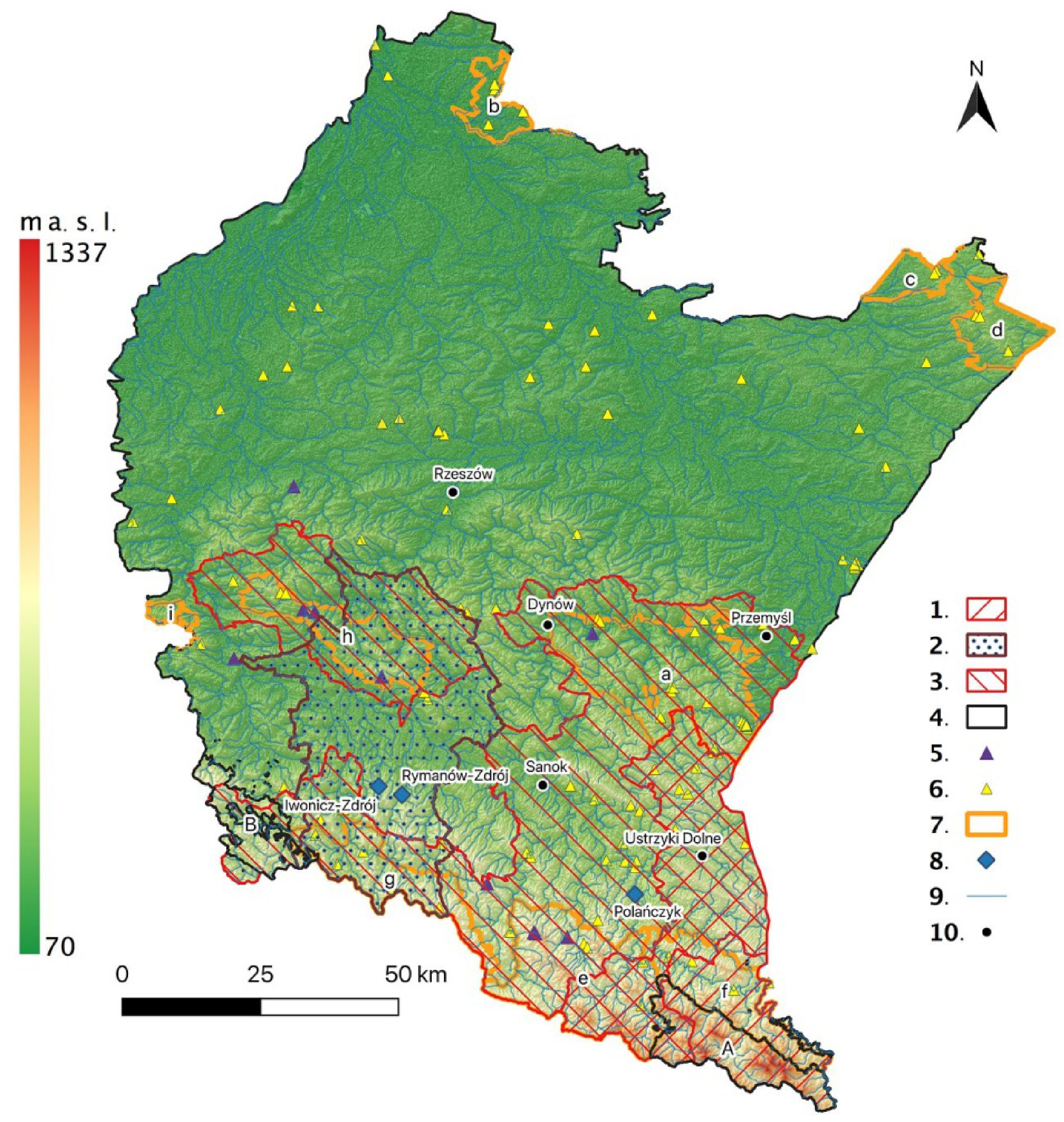
The potential geoparks are located in south-eastern Poland, in the Podkarpackie Province (Figure 1 and Figure 2). They encompass urban, urban–rural and rural districts (46 in total) within which the potential geoparks are located. The idea of creating geoparks in these areas appeared at the turn of the 21st century. The first one to be proposed was the Flysch Carpathians Geopark [20] that would be located within several existing landscape parks: Cisna-Wetlina Landscape Park, Jaśliska Landscape Park, Czarnorzeki-Strzyżów Landscape Park, Słonne Mountains Landscape Park and Przemyskie Foothills Landscape Park (Figure 2). The next proposal was the Geopark in the High Bieszczady [21] that would cover a smaller area but its area would be more cohesive, with homogeneous natural assets. It would comprise only two landscape parks—the Cisna-Wetlina LP and San Valley LP—forming the buffer zone of the Bieszczady National Park. The third one is the Wisłok Valley—the Polish Texas Geopark [22,32]. It would also partially overlap with two landscape parks (Jaśliska LP and Czarnorzeki-Strzyżów LP) and the Magura National Park (Figure 2). The borders of the landscape parks were delineated according to natural environment criteria, and they do not coincide with the boundaries of administrative units. Therefore, the study has encompassed the entire districts located within the existing landscape parks and the potential geoparks.
2.1. Geoheritage
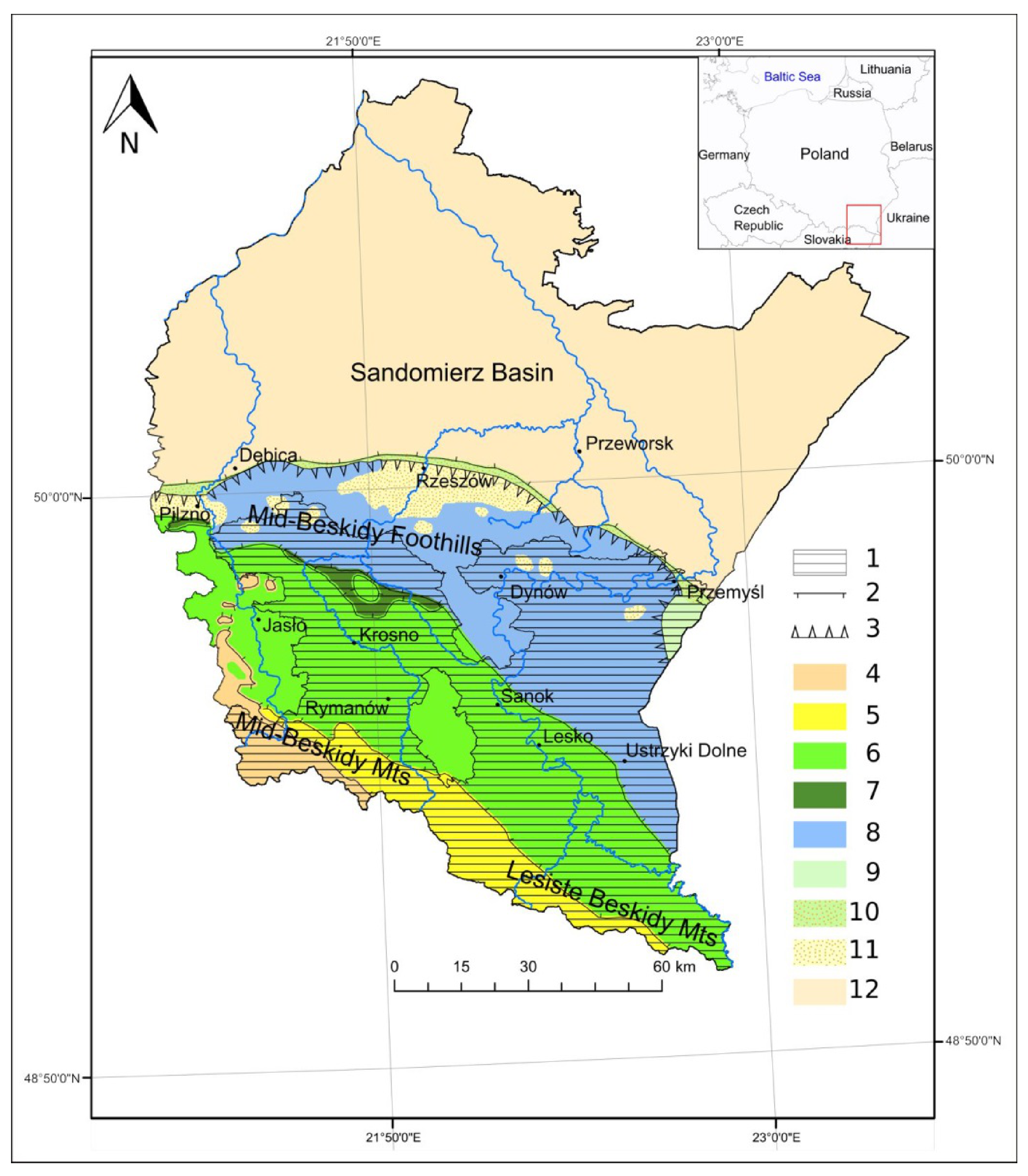
The natural environment of areas designated as the potential geoparks is diverse, particularly from a geological and geomorphological perspective. The southern part of the province is located in the Outer Carpathians (referred to as the Flysch Carpathians). They have complex geological structure and tectonics, which makes them attractive from the perspective of geotourism. They are mainly composed of flysch formations that were developed from marine sediments in a vast synclinal sedimentary basin, starting from the Upper Cretaceous (Jurassic) until the Palaeogene (Lower Miocene). These are complexes of alternating beds of conglomerates, sandstone, mudstone and claystone. These sediments are accompanied by secondary carbonate and silica rocks. As a result of tectonic movements in the Miocene, the flysch rocks were detached from their base and transported from the south to the north where they were thrust on each other, forming nappes—the main tectonic units of the Carpathians. The following nappes occur within the study area: the Magura Nappe, the Dukla Nappe, the Silesian Nappe, the Subsilesian Nappe, the Skole Nappe and the Stebnica Nappe in the Rzeszów–Przemyśl region. In the north, in the zone bordering the Pre-Carpathian Depression, the flysch is overlain by patches of Miocene formations that, at the contact with the Skole unit, were folded with the Carpathian flysch, forming the Zgłobice Nappe (Figure 1) [33].
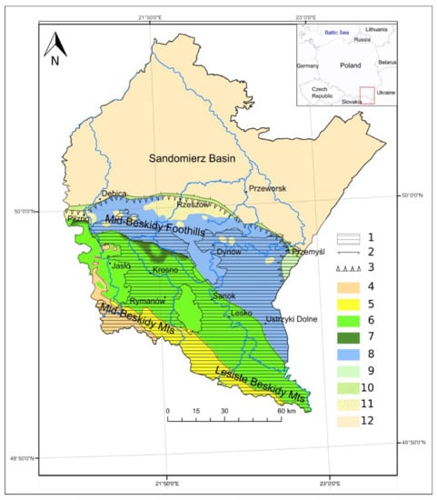
Figure 1.
The geological structure of the bedrock in the study area. (1) Study area; (2) overthrusts of tectonic units; (3) boundary of the Carpathian overthrust; (4) the Magura unit (upper Cretaceous/Palaeogene); (5) the Dukla unit (upper Cretaceous/Palaeogene); (6) the Silesian unit (Jurassic/Oligocene); (7) the Subsilesian unit (upper Cretaceous/Palaeogene); (8) the Skole unit (Cretaceous); (9) the Stebnice unit (Miocene); (10) the Zgłobice unit (Neogene); (11) Miocene patches on flysch; (12) Neogene deposits in the Pre-Carpathian Depression (source of the data [34], modified).
The land relief in the Flysch Carpathians is directly determined by the geological structure. Its basic elements are systems of ranges of foothills and mountains with flattened tops, divided by basins and valleys formed by tectonic movements as well as by erosion and denudation. A system of parallel, narrow ridges and steep valleys form a peculiar kind of relief that corresponds to the arrangement of the steep folds of the nappes [35]. The relative elevations of the individual mountain ranges increase towards the south. Starkel (1972) [36] distinguished the following basic types of relief in this area: relief of valley and basin floors, relief of the foothills and low- and medium-mountain relief. The relief developed in several stages—from the Neogene, Pleistocene and Holocene—up to the recent anthropogenic changes.
The area is located almost entirely in the Vistula basin within the Baltic Sea drainage basin, with only a small fragment in the Dniester basin within the Black Sea drainage basin. It is drained by the river systems of the Wisłok, San and Strwiąż [35]. The geomorphological activity of rivers led to the development of characteristic landscapes of deeply incised valleys and gaps. Such a landscape with a dense river network offers very favourable conditions for the development of tourism and recreation. It is further aided by the presence of numerous protected areas (parks, reserves and natural monuments). The threat of flooding was the reason for the construction of water reservoirs which have additional functions: power generation, water supply and recreation (Solina, Myczkowce, Besko). Another advantage is the occurrence of mineral waters (brine, carbonated water and water with hydrogen sulphide) which became the basis for the development of health resort therapy [37]. The weather conditions, resulting from the characteristics of the Carpathians and their influence on the climate, are also favourable to tourism and recreation. The vegetation cover has a stratified pattern. The area has a high proportion of the forest cover, a considerable share of natural ecosystems, strong biodiversity and occurrence of rare plant species that are under legal protection. In terms of fauna, the parks in the Bieszczady Mountains are the most interesting.
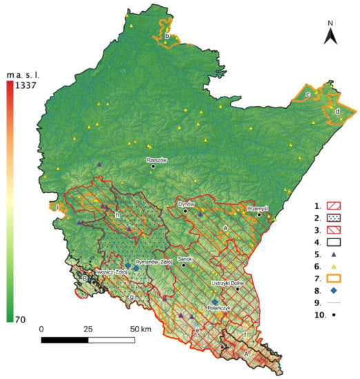
Figure 2.
Topography and forms of nature protection in the Podkarpackie Province. (1) Geopark in the Bieszczady Wysokie Mountains; (2) Wisłok Valley—the Polish Texas Geopark; (3) Flysch Carpathians Geopark; (4) National Parks: (A) Bieszczady Mountains, (B) Magura; (5) inanimate nature reserve; (6) animate nature reserve; (7) Landscape Parks: (a) Przemyskie Foothills, (b) Janów Forest, (c) Solska Forest, (d) South Roztocze, (e) Cisna-Wetlina, (f) San Valley, (g) Jaśliska, (h) Czarnorzeki-Strzyżów, (i) Brzanka Ridge; (8) spa resorts; (9) rivers; (10) cities.
2.2. Forms of Nature Conservation
The diversity of the natural environment components in the southern part of the Podkarpackie Province, particularly the geological structure and land relief, determines the existence of valuable natural and landscape assets (Figure 1 and Figure 2). All legal forms of nature conservation, established pursuant to the Act on Nature Conservation [38], occur here. The most valuable areas are within two national parks—the Bieszczady National Park (established in 1973) and the Magura National Park (established in 1995)—with particularly valuable abiotic environments. Flora and fauna habitats are protected within Natura 2000 areas.
The Bieszczady National Park (districts of Czarna, Ustrzyki Dolne and Lutowiska) encompassing the Bieszczady Wysokie range, lies within two tectonic units: primarily the Silesian Nappe and, in the south-eastern part, the Dukla Nappe (Figure 2). The parallel arrangement of SE–NW-trending ridges is a characteristic feature of the land relief, directly linked to the lithology and basement tectonics. The slopes are dissected by deep valleys of streams [39]. Crude oil was exploited within the boundaries of the Bieszczady National Park, and oil and gas seepage currently occur there [40]. Since 1992, the Bieszczady National Park, along with the Cisna-Wetlina Landscape Park and the San Valley Landscape Park, has been part of the East Carpathians Transboundary Biosphere Reserve (Poland/Slovakia/Ukraine) [41].
The Magura National Park (districts of Dukla and Krempna) is located in the Beskid Niski Mountains (Figure 2). In terms of geology, the Park lies in the outer zone of the Magura Nappe composed of formations that are highly disrupted tectonically. They are composed of thick-bedded Magura sandstones, separated by variegated shale and Inoceramus beds. The Magura sandstone outcrops occur as numerous rock forms (crags). The headwater area of the Wisłoka catchment lies within the park’s boundaries [42].
Within the study area, there are six inanimate nature reserves and nine landscape reserves of high abiotic value (Table 1). The former kind primarily consists of rock clusters, as well as an area of rock rubble and lakes formed by the blocking of a valley by a landslide. In the landscape reserves with valuable abiotic assets, mainly the gap valleys of rivers and parts of slopes featuring rocky outcrops are protected.
The most valuable tree specimens or forms of inanimate nature (e.g., waterfalls, rocks) are protected as natural monuments (a total of 27). They primarily include crags (complexes of rock forms), rocky outcrops, cascades, waterfalls, springs and a cave. A particularly high concentration of natural monuments can be found in the Korczyna district (crags, springs, a waterfall). Most of them are of natural origin, but some of them are a result of human activity, mainly the quarrying of rocks, e.g., the Lesko Stone or the Rocky Wall in Krywe [43].
Documentation sites (form of nature protection in Poland) have been established in some of the geological sites. A total of 26 such sites have been identified in the nine districts covered by the present study. These are mainly natural geological outcrops exposing diverse rocks, including flysch, and land relief features (e.g., residual hills of denudation origin, landslides, parts of river valleys, cascades) as well as typically anthropogenic outcrops such as quarry walls or underground quarries. With as many as 10 documentation sites, the district of Fredropol stands out in this respect [44].

Table 1.
Nature reserves of outstanding geoheritage value after [45].
Table 1.
Nature reserves of outstanding geoheritage value after [45].
| Name | Year of Establishment | Locality/District | Area (ha) | Subject of Protection |
|---|---|---|---|---|
| Zwiezło | 1957 | Duszatyn/Komańcza | 2.2 | Two barrier lakes (covering a total of 1.74 ha), formed by the damming of the Olchowaty stream by a landslide from the slopes of Chryszczata mountain |
| Prządki im. prof. Świdzińskiego | 1957 | Czarnorzeki and Korczyna/Korczyna | 13.6 | Group of sandstone rocks distinguished by characteristic forms resulting from aeolian erosion |
| Gołoborze | 1969 | Rabe/Baligród | 13.9 | An area of rock rubble becoming gradually overgrown by a forest; blocks of sandstone of varying size, often having the form of flat slabs |
| Herby | 1999 | Jazowa and Podlesie/Frysztak and Wiśniowa | 145.7 | Rocky outcrops at the top of the Herby range, covered by a hornbeam and beech forest; the gap valley of the Wisłok valley known as “Brama Frysztaka” |
| Kamień nad Rzepedzią | 2012 | Rzepedź/Komańcza | 91.8 | A group of Eocene sandstone rocks along with the surrounding trees |
| Kozigarb | 2012 | Bachórzec, Słonne/Dubiecko | 33.3 | A hill in a meander of a river, covered by a beech wood, with rich microrelief and deep V-shaped stream valleys |
| Sine Wiry | 1987 | Łuh, Zawój and Podlanki/Cisna and Solina | 450.4 | Gap valley of the Wetlina river along with the surrounding forest complex |
| Krywe | 1991 | Krywe, Tworylne and Hulskie/Czarna and Lutowiska | 511.7 | Part of the San valley at the foot of the Otry range, featuring many interesting plant communities |
| Zespół Jasiołki | 1993 | Wola Niżna and Lipowiec/Komańcza | 1585.0 | Headland of the Wisłok and Jasiołka rivers with natural plant communities |
| Przełom Osławy pod Duszatynem | 2000 | Duszatyn/Komańcza | 322.4 | Part of the Osława valley between Smolnik and Turzańsk |
| Kamień nad Jaśliskami | 2000 | Wola Niżna, Posada Jaśliska and Lipowiec/Dukla | 302.3 | An example of relief typical of the Beskid Niski Mountains, encompassing the summit and slopes of the Kamień mountain along with rock forms, forest communities and wetlands |
| Przełom Osławy pod Mokrem | 2003 | Wysoczany and Mokre/Zagórz | 142.7 | The gap valley of the Osława river and forest communities with protected plant species |
| Koziniec | 2004 | Myczkowce/Solina | 28.6 | Part of the forested slope of the Koziniec mountain featuring numerous rocky outcrops, sites of rare plant species and xerothermic communities |
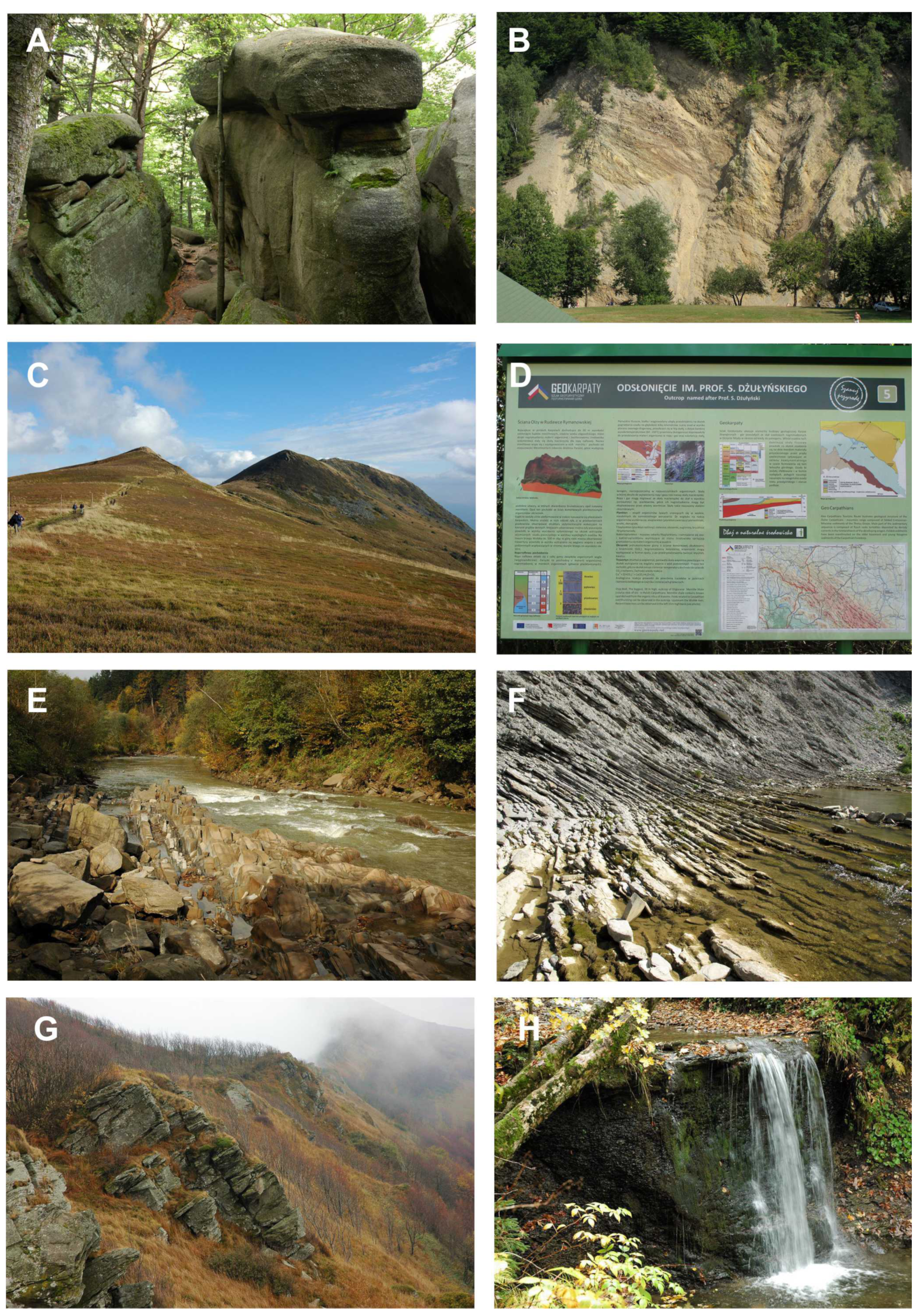
A total of 259 geosites can also be found in the area, among them the most valuable inanimate nature sites representing various forms of geodiversity and documenting the geological history and geological processes, e.g., individual outcrops and clusters of outcrops of natural and anthropogenic origin; erratics; landforms formed by accumulation and denudation; sites with interesting minerals or rocks, water sites; traces of mining activity; interesting landscape forms, etc.—significant for science, culture and history (Figure 3). The geosites have not been formally marked in the places where they occur; they have only been recorded in Poland’s Central Register of Geosites. They partially overlap with the above-mentioned forms of nature conservation. Most of them are situated in the districts of Korczyna and Niebylec, while the greatest typological diversity occurs in the districts of Baligród, Dukla and Korczyna. Two hundred and twenty-three caves occur in the Carpathian flysch. Most of them are small caves up to a few metres long. The largest caves are located in the Dukla district (in the “Osuwiska w Lipnicy” Natura 2000 area): Jaskinia Słowiańska–Drwali (601 m long and over 23 m deep), Gangusiowa Jama (190 m long and over 11 m deep), Lodowa Szczelina (166 m long and 10.5 m deep).
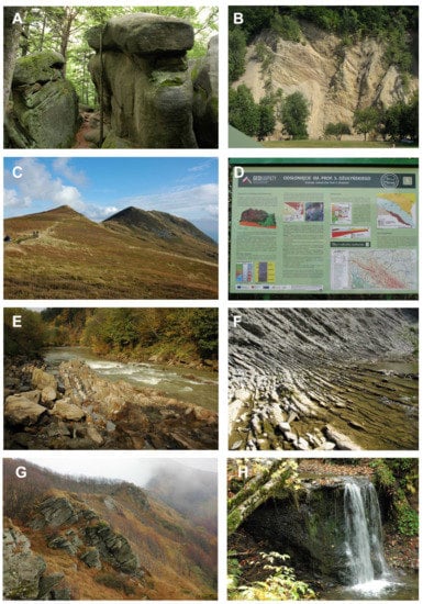
Figure 3.
Examples of valuable geoheritage sites in the area of the potential geoparks. (A) rock forms in the Diabli Kamień Nature Reserve; (B) flysch rock outcrop on the slopes of the Wisłok valley in Rudawka Rymanowska; (C) Tarnica, the highest peak of the Bieszczady Mountains; (D) example of an interpretation panel of the GeoKarpaty trail, (E) Sine Wiry Nature Reserve; (F) the rocky channel of the Wisłok river; (G) rock form outcrops along the ridges of the Bieszczady Mountains; (H) waterfall in Bieszczady Mts. (photo by: W. Zgłobicki and B. Baran-Zgłobicka).
2.3. Cultural Heritage
Over the centuries, the study area has been in the ethnic, political and religious borderland. Such a location has resulted in the development of cultural heritage, preserved in many places until today and distinguished by great diversity arising from the multi-ethnic and multi-denominational past (Figure 4). An outline of the settlement network in the Carpathians crystallised in the Middle Ages (mainly in the 14th century), after a series of incorporations under German law. From the 15th century, settlements were established under Wallachian law. Among the population, involved in animal herding, two ethnic areas evolved: the Lemkos in the east and the Boykos in the west. From the mid-19th century, the region developed economically, with the construction of railways and dynamic development of the oil industry, among other aspects. Tourism and health resorts also started to develop in the second half of the 19th century. During the First World War, the Carpathians saw some long-lasting military operations which left numerous military cemeteries in their wake. More tragic events occurred during the Second World War (extermination of the Jewish population), while the post-war years saw the expulsion of the Greek Catholic and Orthodox population [46].
In the second half of the 19th century, a new spatial complex—a spa—appeared in the Carpathians, modelled after European spas. The Carpathian spa is characterised by wooden architecture, loosely drawing on Tyrolean and Swiss models. The basic compositional element is the natural therapy complex with the accompanying layout of diverse vegetation [47]. Two old spas—Iwonicz Zdrój and Rymanów Zdrój—and a new health resort in Polańczyk operate in the Beskid Niski Mountains (Figure 2). The health resorts are adjacent to areas with valuable natural assets, protected under law, which additionally increases their value for tourism. Mineral waters are a significant resource of the potential geoparks “The Flysch Carpathians” and “The Wisłok Valley – The Polish Texas” [32,48].
Pursuant to the Act on the Protection and Care of Historic Monuments (JoL No. 2020 item 282) [49], immovable historic monuments are protected under the following forms: entry in the register of monuments, recognition as a monument of history, establishment of a cultural park or determination of the scope of protection in planning documents (Art. 7). Within the study area, there are 1148 sites entered in the register of monuments: from 2 sites in the Solina district to 243 sites in the city of Przemyśl. They are diverse in terms of their functions as they include religious complexes of various denominations, palaces and manor houses, public buildings, residential buildings, industrial facilities, etc. They also include sites of particular significance for cultural heritage, i.e., four monuments of history (mine in Bóbrka, castle complex in Krasiczyn, Old Town complex in Przemyśl and the Przemyśl fortress) and one cultural park (Old Town Hill in Krosno). Four sites have been inscribed in the UNESCO World Heritage List, namely the so-called tserkvas in the Smolnik in Lutowiska district and in Turzańsk in Komańcza district (Wooden Tserkvas of the Carpathian Region in Poland and Ukraine, 2013) and the Catholic churches in Haczów, Haczów district and in Blizne, the Jasielnica Rosielna district (Wooden Churches of Southern Małopolska, 2003) [50]. In addition, the beech forests of primeval character in the Bieszczady National Park were entered on the UNESCO List in 2019 [51].
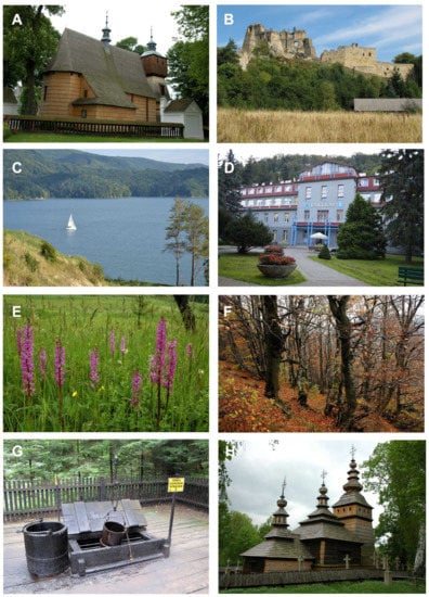
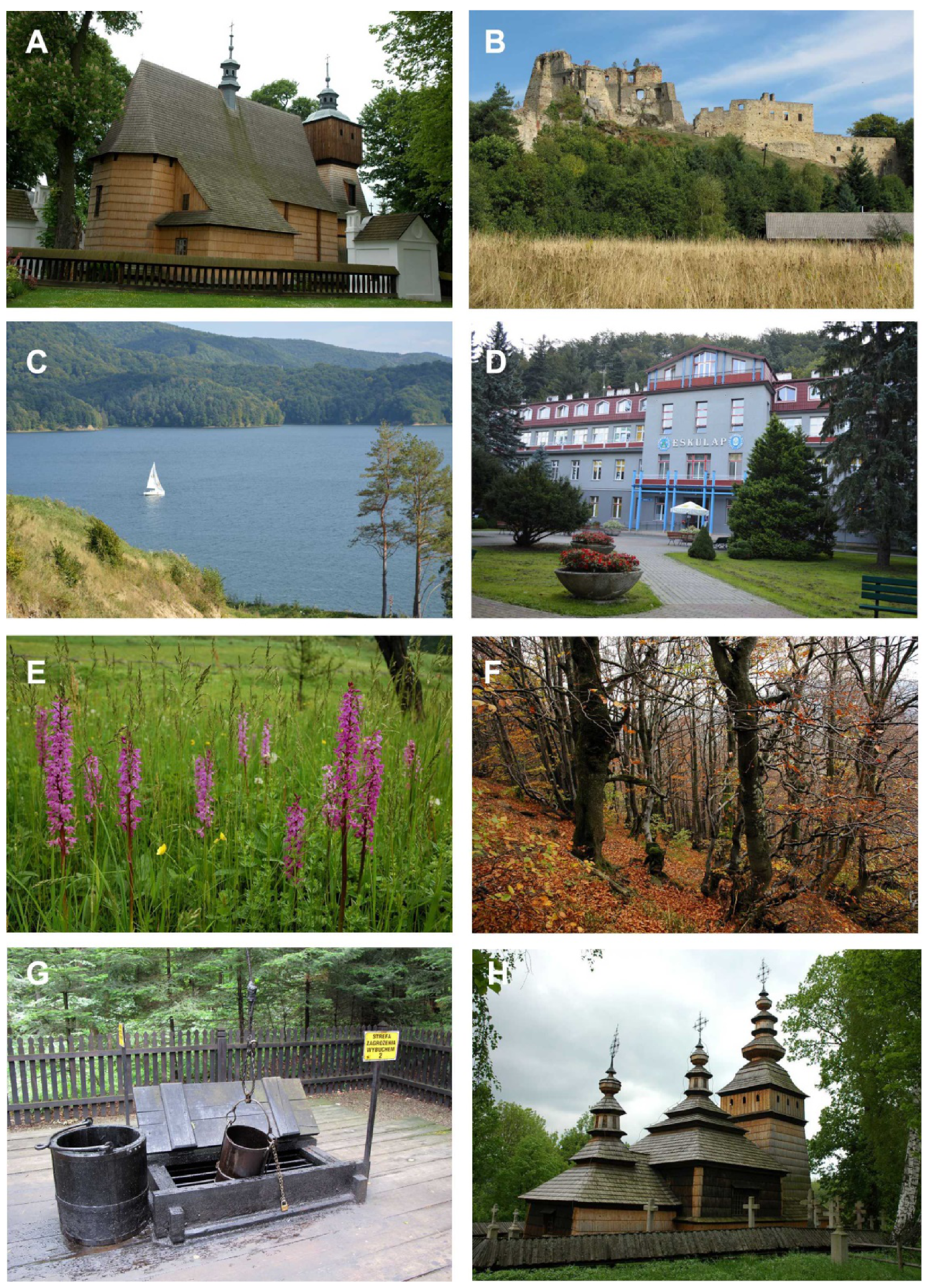
Figure 4.
Selected biotic and cultural heritage sites in Podkarpackie Province. (A) church in Blizne village, on the UNESCO World Heritage List; (B) Kamieniec castle in Odrzykoń; (C) Lake Solina; (D) health resort in Rymanów-Zdrój spa; (E) orchids on the meadows of the Beskid Niski Mountains; (F) the Carpathian beech forest in the Bieszczady Mountains; (G) the Skansen-Museum of the Oil and Gas Industry; (H) Greek Catholic church in Kotań (photo by: W. Zgłobicki and B. Baran-Zgłobicka).
2.4. Tourist Development
The valuable natural assets and cultural heritage of the area are definitely of tourist interest. The landscape parks within the study area vary a lot in terms of tourist development. It should be remembered that adequate infrastructure not only makes a given area accessible, but it also enables the volume of tourist traffic to be controlled so as not to exceed the resilience of the natural environment [52]. The accommodation infrastructure—the basic determinant of the possibilities of developing the tourist function—is quite varied in the study area. It comprises 20,515 beds (Statistics Poland, data for 2019) [53]. The accommodation infrastructure is most developed in districts linked to the Cisna-Wetlina Landscape Park and the San Valley Landscape Park (districts of Ustrzyki Dolne—1900 beds, 120,604 total overnight stays provided; Cisna—1426 beds, 58,744 total overnight stays; Lutowiska—1407 beds, 64,991 total overnight stays). The structure of the accommodation facilities is dominated by private lodgings (guest rooms and agritourist lodgings), while holiday centres are of smaller importance. Hotels are located primarily in towns. Health resort districts are at the top with regard to the number of beds. The spa infrastructure is located in Iwonicz-Zdrój (7 facilities and 909 beds), Rymanów-Zdrój (5 facilities and 479 beds) and Polańczyk (5 facilities and 908 beds). The development of the catering infrastructure is determined by the development level of the accommodation infrastructure and intensity of tourist traffic. Bistros and small food outlets predominate. Establishments offering traditional cuisine are developing gradually.
In the case of areas (primarily non-urbanised), the statistical data on the number of beds and overnight stays provided are highly underestimated. Studies by Zawilińska (2010) [54], conducted in districts administratively linked with the Carpathian landscape parks, indicate a significant underestimation of the number of beds in the official records of Statistics Poland [55] (number of beds according to Statistics Poland vs. number of beds according to Zawilińska [54]): Jaśliska LP: 2293 vs. 587; Cisna-Wetlina LP: 9634 vs. 4062; San Valley LP: 7683 vs. 3229; Słonne Mountains LP: 3726 vs. 1714; Czarnorzeki-Strzyżów LP: 558 vs. 99; Pogórze Przemyskie LP: 1265 vs. 604. These statistics do not include data on guest rooms and beds in agritourist farms or guests staying at non-registered lodgings, e.g., at campsites, with friends or in second homes.
Numerous tourist trails (walking, cycling, horse-riding and car trails) have been designated thanks to the cultural and historical heritage, the tangible traces of the region’s multi-cultural past, natural environment assets and valuable landscapes. Cultural trails are among the most interesting ones: the Wooden Architecture Trail, the Hasidic Route, the Route of the Lubomirski Family Estates, the Trail of Historical Houses and Gardens, the Wallachian Culture Trail, the Trail of the Carpathian Shrines, the Military Cemetery Trail, the Blue San Trail, the Papal Trail or the Icons Trail. The Petroleum Trail links places associated with the exploitation of crude oil (Figure 4).
The Wooden Architecture Trail comprises wooden historic buildings that have had a whole range of different functions: religious buildings (Catholic, Orthodox and Uniate churches, belfries, parsonages), public buildings, industrial facilities (flour mills, windmills, smithies, sawmills), manor houses, complexes of small town and rural architecture, health resort architecture. Buildings and historic monuments of tangible folk culture have been collected in the Rural Architecture Museum in Sanok [56].
The most important industrial heritage site in the study area is the oldest crude oil mine in Bóbrka; crude oil deposits occur in the Ciężkowice sandstone. The year 1853, when Ignacy Łukasiewicz and Jan Zeh distilled and refined crude oil and when kerosene lamps were introduced in a hospital in Lviv, is regarded as the beginning of the petroleum industry in Poland. As early as 1854, a crude oil mine was opened in Bóbrka near Krosno. The mine has survived military operations and political changes. In the 1950s, a new oilfield was discovered and has been exploited until today. In 1961, the Ignacy Łukasiewicz Skansen-Museum of the Oil and Gas Industry was established at the mine. Two original oil wells from the 19th century have been preserved there [57,58].
3. Methods
Assets significant from the perspective of tourism development were assessed using common methods for multi-criteria assessment [59,60,61,62,63]. Six groups of criteria were distinguished: (i) geoheritage assets—geodiversity (5 criteria); (ii) biotic environment assets (3 criteria); (iii) cultural heritage assets (5 criteria); (iv) the potential of tourist attractiveness (4 criteria); (v) the potential of tourist infrastructure (4 criteria); (vi) the potential for development (4 criteria). Analyses were carried out for 46 districts located within the potential geoparks. The assessment rules and criteria are presented in Table 2, while the sources of data are shown in Table 3.

Table 2.
The rules of assessing the tourism potential of districts.

Table 3.
Sources of data.
4. Results
4.1. Potential of Geodiversity
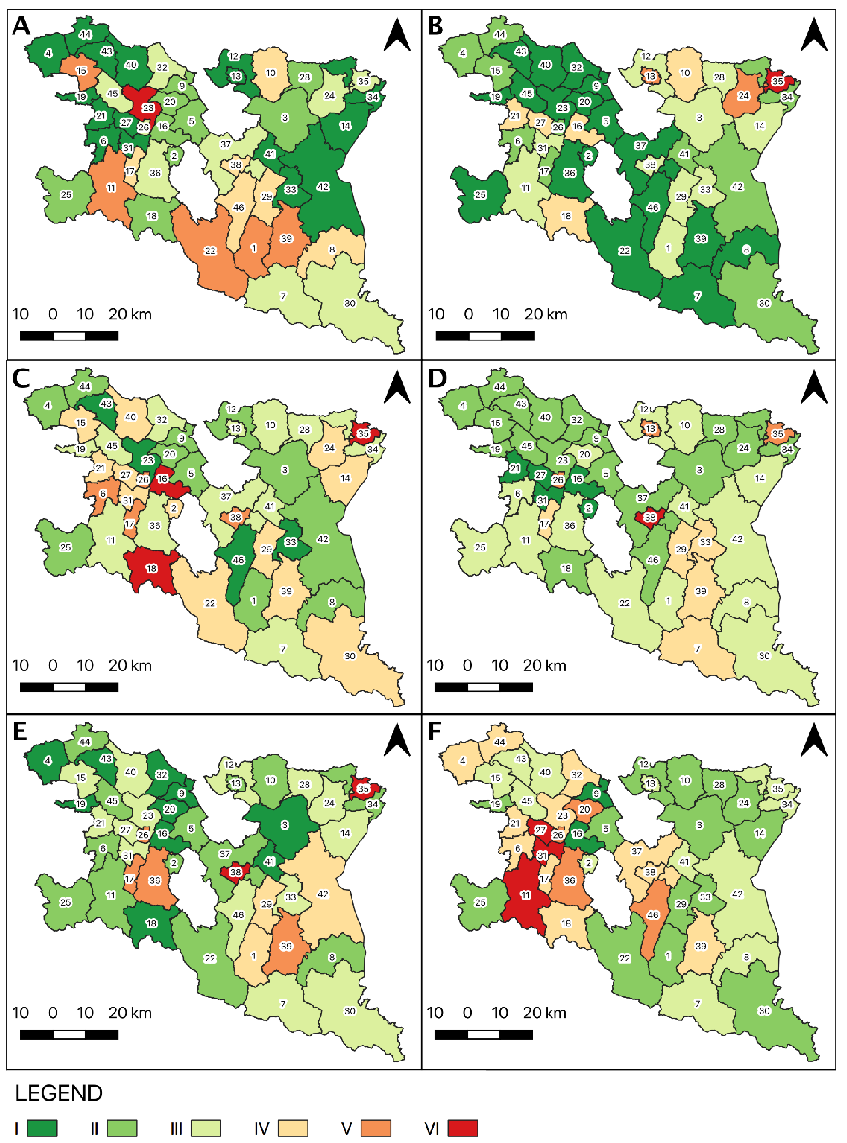
Inanimate nature reserves, protecting the most valuable assets of geoheritage, occur in 10 districts under study, among which five districts have one nature reserve each. A monument, or “monuments” of inanimate nature occurs in 11 districts—usually these are 1 to 3 monuments even though one district features as many as 19—while documentation sites occur in nine districts (one site per district in four districts). Geosites are located in 36 districts, with 20–25 geosites per district occurring in five districts. Taking into account the average for the entire study area, there is one geosite per 10 km2, while in districts with the greatest number of geosites, their concentration reaches one geosite per 1–2 km2. In 13 districts, there are more than three types of geosites, e.g., natural geological outcrops, anthropogenic geological outcrops, remnants of mining activity). The districts have a varied potential of geoheritage (Figure 4). Six districts were assigned to category V and VI, while 16 districts have a low potential (category I). In spatial terms, districts with the highest potential are located in the southern and western part of the Podkarpackie Province (the Polish Texas and Bieszczady Wysokie geoparks). The San River Valley LP, Cisna-Wetlina LP, Jaśliska LP and Czarnorzeki-Strzyżów LP are situated within the boundaries of these districts (Figure 5A).
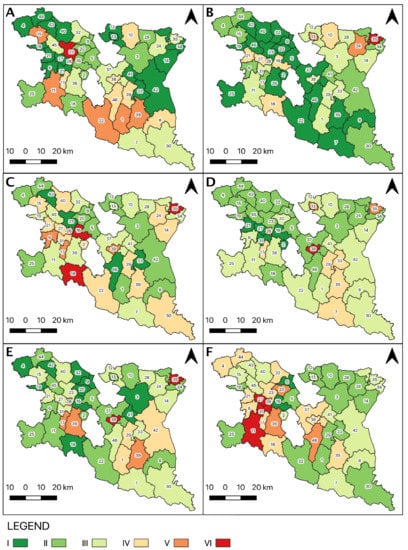
Figure 5.
Differences in potential among the studied districts: (A) potential of geodiversity; (B) potential of animate nature; (C) cultural potential; (D) the potential of tourist attractiveness; (E) potential of tourist infrastructure; (F) development potential. Potential: I—very low, II—low, III—moderate, IV—moderately high, V—high, VI—very high. Districts: 1. Baligród; 2. Besko; 3. Bircza; 4. Brzostek; 5. Brzozów; 6. Chorkówka; 7. Cisna; 8. Czarna; 9. Domaradz; 10. Dubiecko; 11. Dukla; 12. Dynów; 13. Dynów—city; 14. Fredropol; 15. Frysztak; 16. Haczów; 17. Iwonicz Zdrój; 18. Jaśliska; 19. Jasło; 20. Jasienica Rosielna; 21. Jedlicze; 22. Komańcza; 23. Korczyna; 24. Krasiczyn; 25. Krempna; 26. Krościenko Wyżne; 27. Krosno; 28. Krzywcza; 29. Lesko; 30. Lutowiska; 31. Miejsce Piastowe; 32. Niebylec; 33. Olszanica; 34. Przemyśl; 35. Przemyśl-city; 36. Rymanów; 37. Sanok; 38. Sanok-city; 39. Solina; 40. Strzyżów; 41. Tyrawa Wołoska; 42. Ustrzyki Dolne; 43. Wiśniowa; 44. Wielopole Skrzyńskie; 45. Wojaszówka; 46. Zagórz.
4.2. Potential of Animate Nature
Animate nature reserves occur in 10 districts, including four districts that have 2–4 reserves each. Animate nature monuments have been found in all but two districts. On average, there are 22 monument per district, with the maximum being 121. The proportion of areas included in the Natura 2000 network varies a lot and ranges from 0 to 99% of the district area; it is 33% on average. The potential of animate nature, determined based on the occurrence of conservation forms of high rank, is not very high in the districts under study: 17 have been assigned to the lowest category, while only eight to categories IV to VI. Districts with the highest potential in this respect are located in the north-eastern part of the province (Figure 5B).
4.3. Cultural Potential
Sites included in the UNESCO World Heritage List occur in four of the districts under study. Each of them features historic monuments, but of course most sites are located in districts with larger towns such as Przemyśl, Krosno or Sanok (from 50 to 243 sites). In a few districts, no more than five historic monuments occur per district. There are various kinds of historic monuments: 35 districts have over 10 types of monuments each, e.g., tserkvas, churches, cemeteries, palaces, manor houses, public buildings, burghers’ houses, etc. Cultural trails have been designated in 25 districts, and cultural events take place in nearly all districts. On the other hand, cultural parks and monuments of history occur in just a few districts. The districts under study have a moderate level of cultural potential, with only six of them belonging to categories with the highest potential (V–VI). Districts with high and medium potential are distributed quite evenly across the entire province (Figure 5C).
4.4. Potential of Tourist Attractiveness
This kind of potential comprises elements that have not been assigned to the first two groups. It shows strong links to the environmental characteristics of the area. The southern part of the province, with higher, often tree-covered mountain ranges and a greater density of the river network, has a clearly higher potential with particularly attractive landscapes. The highest potential occurs in areas where it is additionally enhanced by the occurrence of unique tourist attractions—Przemyśl, Sanok, Dynów—and cultural events (Figure 5D). The differences in this potential among the districts under study are not very big, with 35 districts assigned to category II, III and IV.
4.5. Potential of Tourist Infrastructure
The number of accommodation places in the districts under study varies quite considerably, ranging from 0.1 to 35 per 1 km2. It is similar in the case of overnight stays provided: this parameter ranges from 2 to 6000 per 1 km2. This number is the highest in towns and health resorts. The density of the road network shows smaller variation, from 0.2 to 1 km per 1 km2, and the density of bike paths varies the least: from 0.2 to 1.2 km per km2. Ten districts have been assigned to category I of the potential, and seven districts to category V and VI. Districts with the highest potential in this respect are located in the central part of the province (Figure 5E).
4.6. Development Potential
According to the adopted methodological framework, the districts under study have quite a good development potential. Nineteen districts belong to the top three categories, and only one district to the lowest category. However, on average, only 14% of the area of the districts is covered by local spatial development plans. On average, the registered unemployed account for 7% of the working age population, while the average revenue of the district budget amounts to PLN 5400 per one inhabitant. The highest development potential occurs in the western part of the province (Figure 5F).
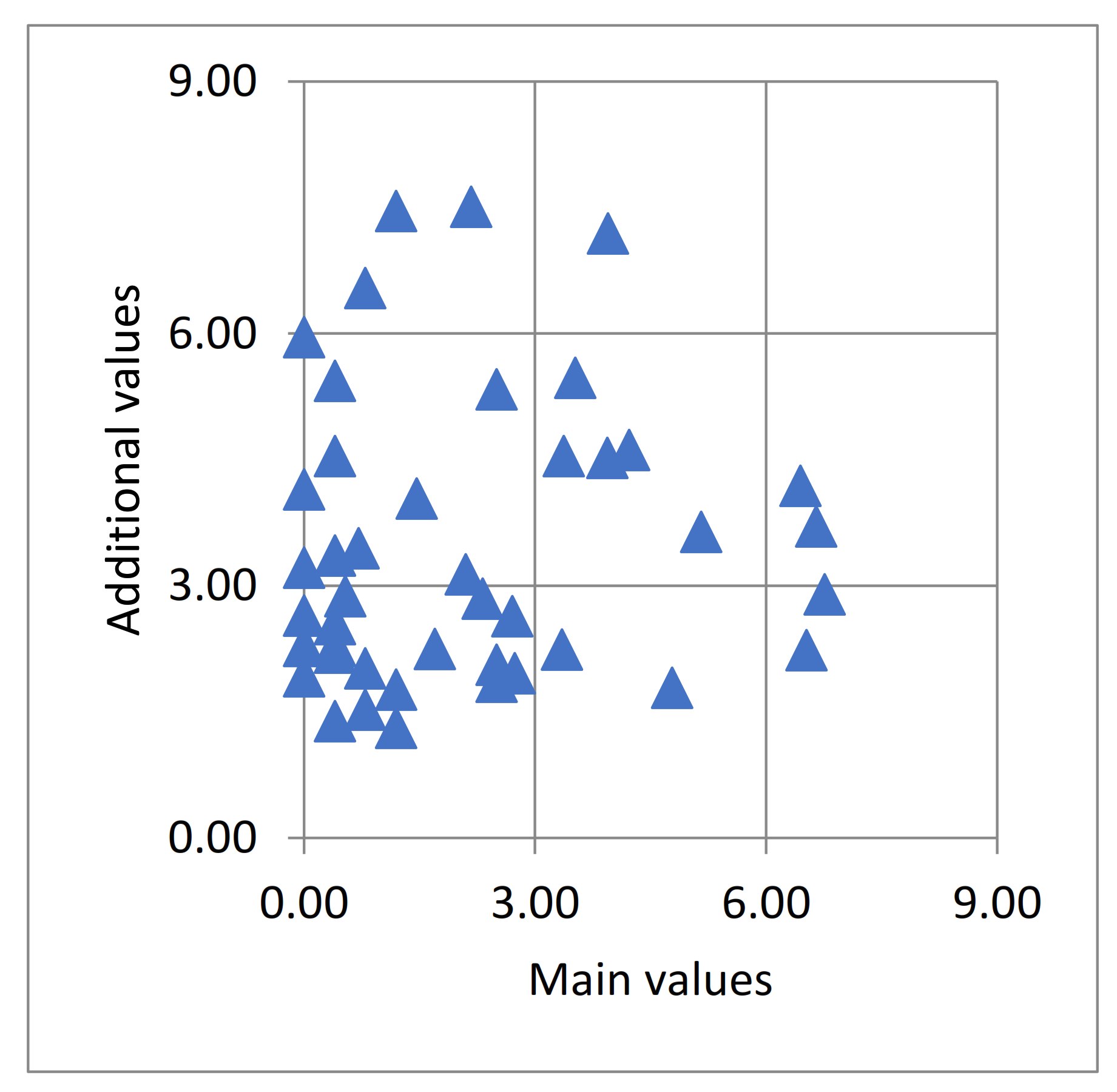
To carry out a comprehensive assessment of the potential of the districts under study, a two-dimensional matrix was prepared based on geodiversity potential and additional values (Figure 6). The largest cluster of districts has low potentials (18 districts in categories I and II); another twelve districts belong to a cluster with medium or high potential (categories III to VI). According to the adopted methodological framework, high potential (categories V and VI) of the main and additional values does not occur in any of the districts under study (Figure 6).
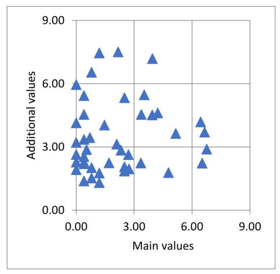
Figure 6.
The main values (geodiversity potential) and additional values (average of the remaining five potentials) of the districts under study.
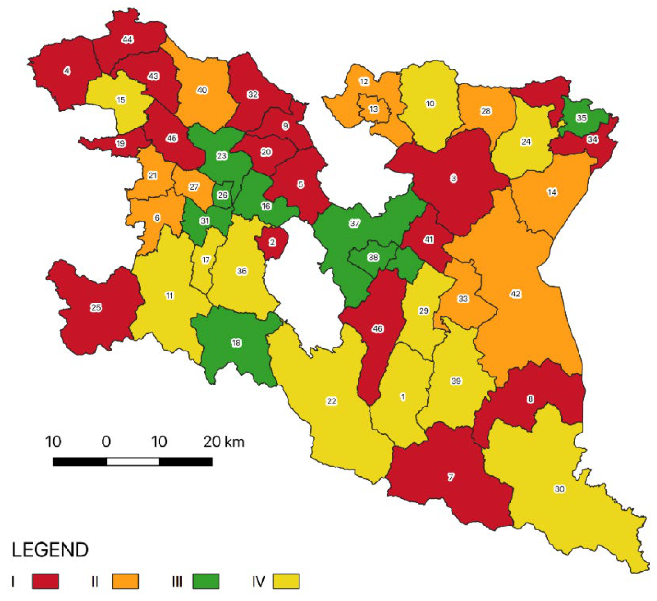
The clustering of districts based on the results of the assessment has enabled the identification of four clusters (Table 4, Figure 7) where the following sets of characteristics (potentials) occur:
- (i)
- Cluster 1 (17 districts)—predominance of category I and II of potential, category IV occurs sporadically for individual potentials;
- (ii)
- Cluster 2 (10 districts)—predominance of category III of potential, categories IV and V occur sporadically;
- (iii)
- Cluster 3 (11 districts)—predominance of category IV and V of potential, districts with the highest geodiversity potential belong to this cluster;
- (iv)
- Cluster 4 (eight districts)—high diversity of categories of potential, in each district at least one kind of potential belongs to category VI (very high).
The method used has indicated districts with high geodiversity potential and high levels of other kinds of potential—Iwonicz-Zdrój, Lesko, Solina, Dukla, Frysztak—as well as districts with high geodiversity potential and moderate/low levels of other kinds of potential—Dubiecko, Korczyna.

Table 4.
Differences in tourism potential and assignment to clusters. A—potential of geodiversity; B—potential of animate nature; C—cultural potential; D—the potential of tourist attractiveness; E—potential of tourist infrastructure; F—development potential.
Table 4.
Differences in tourism potential and assignment to clusters. A—potential of geodiversity; B—potential of animate nature; C—cultural potential; D—the potential of tourist attractiveness; E—potential of tourist infrastructure; F—development potential.
| District | Landscape Park | Planned Geopark | Potentials | Cluster | |||||
|---|---|---|---|---|---|---|---|---|---|
| A | B | C | D | E | F | ||||
| Jasło | - | DW | I | I | III | II | I | II | 1 |
| Wielopole Skrzyńskie | C-S | KF | I | I | I | II | I | III | 1 |
| Tyrawa Wołoska | GS | KF | I | II | III | III | I | III | 1 |
| Brzostek | C-S | KF | I | II | II | II | I | IV | 1 |
| Przemyśl | PP | KF | I | II | III | II | II | II | 1 |
| Wiśniowa | C-S | KF | I | II | II | II | II | IV | 1 |
| Besko | - | DW | II | I | IV | I | II | III | 1 |
| Domaradz | C-S | KF, DW | II | I | II | II | I | I | 1 |
| Brzozów | - | DW | II | I | II | II | II | II | 1 |
| Jaśliska | J | KF, DW | II | I | II | III | I | V | 1 |
| Krempna | J | KF | II | I | II | III | II | II | 1 |
| Bircza | PP | KF | II | III | II | II | I | II | 1 |
| Niebylec | C-S | KF, DW | III | I | III | II | I | IV | 1 |
| Wojaszówka | C-S | KF, DW | III | I | III | II | II | III | 1 |
| Cisna | C-W | KF, BW | III | I | II | IV | III | III | 1 |
| Zagórz | C-W | KF, BW | IV | I | I | II | III | V | 1 |
| Czarna | C-W, DS | KF, BW | IV | I | II | III | II | III | 1 |
| Krosno | - | DW | I | II | V | I | V | V | 2 |
| Strzyżów | C-S | KF, DW | I | II | IV | II | III | III | 2 |
| Chorkówka | - | DW | I | II | V | III | II | IV | 2 |
| Dynów | PP | KF | I | III | II | III | III | II | 2 |
| Fredropol | PP | KF | I | III | IV | III | III | II | 2 |
| Olszanica | GS | KF | I | III | I | IV | III | II | 2 |
| Jedlicze | - | DW | I | IV | IV | I | III | IV | 2 |
| Dynów–City | PP | KF | I | V | III | V | II | III | 2 |
| Ustrzyki Dolne | GS, PP | KF | II | II | II | III | IV | III | 2 |
| Krzywcza | PP | KF | II | III | III | II | III | IV | 2 |
| Rymanów | - | DW | III | I | III | III | V | V | 3 |
| Lutowiska | DS | KF, BW | III | II | IV | III | III | II | 3 |
| Krasiczyn | PP | KF | III | V | IV | II | III | II | 3 |
| Iwonicz-Zdrój | - | DW | IV | II | V | IV | V | IV | 3 |
| Lesko | GS | KF | IV | III | IV | IV | IV | II | 3 |
| Dubiecko | PP | KF | IV | IV | III | III | II | II | 3 |
| Komańcza | C-W, J | KF, BW | V | I | IV | III | II | II | 3 |
| Solina | C-W, DS | KF, BW | V | I | IV | IV | III | IV | 3 |
| Frysztak | C-S | KF | V | II | IV | II | III | III | 3 |
| Dukla | J | KF, DW | V | III | III | III | II | VI | 3 |
| Baligród | C-W | KF, BW | V | III | II | III | IV | II | 3 |
| Haczów | - | DW | II | IV | VI | I | I | I | 4 |
| Jasienica Rosielna | C-S | KF, DW | II | IV | VI | II | I | IV | 4 |
| Korczyna | C-S | KF, DW | VI | I | I | III | III | IV | 4 |
| Krościenko Wyżne | - | DW | I | IV | IV | I | III | VI | 4 |
| Miejsce Piastowe | - | DW | I | III | IV | I | III | VI | 4 |
| Przemyśl–City | PP | KF | III | VI | VI | V | VI | II | 4 |
| Sanok | GS | KF | III | I | III | II | VI | IV | 4 |
| Sanok–City | GS | KF | IV | III | V | VI | V | IV | 4 |
Source: authors’ own materials. Legend: C-W—Cisna-Wetlina Landscape Park; C-S—Czarnorzeki-Strzyżów Landscape Park; DS.—San River Valley Landscape Park; GS—Słonne Mountains Landscape Park; J—Jaśliska Landscape Park; PP—Przemyśl Foothills Landscape Park; BW—Geopark in the Bieszczady Wysokie Mountains; DW—Wisłok Valley—the Polish Texas; KF—Flysch Carpathians Geopark. Potential: I—very low; II—low; III—moderate; IV—moderately high; V—high; VI—very high.
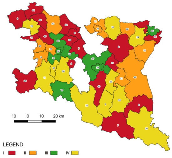
Figure 7.
Spatial picture of the clustering results. I—Cluster 1, districts with low potentials; II—Cluster 2, districts with moderate potentials; III—Cluster 3, districts with high potentials; IV—Cluster 4, districts with varied potentials, including high potentials.
Figure 7.
Spatial picture of the clustering results. I—Cluster 1, districts with low potentials; II—Cluster 2, districts with moderate potentials; III—Cluster 3, districts with high potentials; IV—Cluster 4, districts with varied potentials, including high potentials.
5. Discussion
5.1. Tourist Assets of Landscape Parks
The tourist attractiveness of a specific area consists of natural environment and cultural assets, tourist development and transport accessibility. A significant factor is the tourism policies conducted at different levels of government in a given country, including policies related to the organisation of the tourism management system and support of its development, including financial support. Owing to the cultural and natural heritage and landscape values, the area of the Carpathians in the Podkarparckie Province is indicated in national and regional strategy and planning documents as predisposed to the development of leisure and tourism [64,65]. Since no geopark has been established in the Polish Carpathians yet, the tourist asset assessments thus far have been conducted within landscape parks.
Warszyńska and her team (1980) [66] conducted a tourist attractiveness assessment for the natural environment assets of the Carpathian landscape parks. Taking into account the mean values of indicators for localities administratively linked to landscape parks, she assessed the tourist attractiveness of the individual parks. Among the parks that could become geoparks, the Cisna-Wetlina Landscape Park and the San Valley Landscape Park have been assigned the highest category in the general attractiveness category (Table 5). A high general tourist attractiveness is indicative of favourable conditions for tourism throughout the year, and thus the possibility of developing tourism as the main or equivalent function [67].

Table 5.
Assessment of the attractiveness of natural environment assets in landscape parks (according to [54,66]).
According to the methodological framework prepared by Warszyńska (1985) [66], Zawilińska (2010) [54] assessed the tourist function of districts administratively linked with landscape parks, taking into account the size of accommodation infrastructure in relation to the number of inhabitants and area of districts. In the functional structure, tourism has a very high significance in districts administratively associated with the Cisna-Wetlina LP and the San Valley LP. It constitutes the main—or one of the main—functions in the economy of the districts of Cisna and Solina, or an equivalent or supplementary function in the districts of Lutowiska and Czarna as well as the district of Krempna in the Jaśliska LP and district of Lesko in the Słonne Mountains LP. In some districts, it is a supplementary function, e.g., Komańcza, Jaśliska, Ustrzyki Dolne, Sanok, Fredropol, Krasiczyn. On the other hand, the tourist function is the least developed (in an initial stage) in the districts in the western part of the Słonne Mountains LP and Pogórze Przemyskie LP as well as in some districts in which the Czarnorzeki-Strzyżów LP is located. In the Pogórze Przemyskie LP and the Czarnorzeki-Strzyżów LP, there are districts where the development of the tourist function has not begun yet.
Zawilińska (2010) [54] used the SWOT analysis to assess the possibilities for the development of tourism in the landscape parks of the Carpathians. Based on that analysis and the assessment of the tourist potential of the natural environment and cultural assets, as well as the level of tourism infrastructure development, she distinguished models of tourism and identified the possibilities and directions of the sustainable development of tourism. In total, she distinguished seven types of landscape parks, according to the characteristics of the tourist function, and formulated four development models for them. In the area of the landscape parks that were indicated as potential geoparks in the Podkarpackie Province, she distinguished three types and two development models (Table 6). Although the abiotic potential was not the subject of a separate assessment, the specific directions of development are universal and can be pursued based on tourist products prepared within the geoparks.

Table 6.
Models of the sustainable development of tourism in landscape parks according to Zawilińska 2010 [54].
The above assessments of districts administratively linked with landscape parks show that the area analysed has a significant tourist potential. Tourism in landscape parks takes advantage of a variety of tourist assets. At the same time, its development hinges on transport accessibility along with the development of tourist infrastructure that will enable pursuit of a given form of tourism. In areas with valuable natural environment assets, the development of mass tourism is not recommended because this form of tourism leads to intensive land development and considerable motor vehicle traffic. In such cases, sightseeing tourism, particularly forms relying on the unique assets of a given area, and ecotourism are preferred. The results of studies by various authors [54,66,67] indicate a very high tourist attractiveness of districts in the Cisna-Wetlina LP and San Valley LP. In their case, the primacy of nature conservation should determine the development of tourism. The tourist function is of enormous significance for the economy of these areas. The situation is similar in the case of the districts of the Jaśliska LP, Słonne Mountains LP and Pogórze Przemyskie LP, where low tourist capacity is accompanied by average tourist assets. The tourist assets in the districts of the Czarnorzeki-Strzyżów LP received the lowest rating. At the same time, these areas show valuable abiotic assets that have justified proposals for establishing geoparks [20,21,22].
5.2. Prospects for the Establishment of Geoparks
Geoparks may play a very significant role in the development of tourism in a given area and may thus foster regional development [68,69]. Therefore, efforts to establish geoparks are undertaken in many areas. However, a given area must meet specific criteria in order to become a geopark. In the case of the European Geoparks Network, the criteria are as follows [70]:
- (1)
- A geopark is an area that comprises unique geological heritage and has a strategy of sustainable territorial development. It must have clearly defined boundaries and sufficient areas allowing real territorial economic development.
- (2)
- It must consist of a specific number of geological sites of special significance in terms of scientific value, rarity, aesthetic value or educational value. Most sites located within a geopark must be part of the geological heritage, but they may also be of an archaeological, ecological, historical or cultural nature.
- (3)
- A geopark plays an active role in the economic growth of its area by improving the overall image based on geological heritage and development of geotourism.
- (4)
- A European geopark has a direct impact on its territory, influencing the living conditions and environment of its inhabitants. Its establishment should be aimed at enabling residents to take advantage of the economic potential offered by the local geoheritage, and to actively manage the entire territory.
In the case of Global Geoparks, the assessment is carried out according to the following criteria: Geology and Landscape; Geoconservation (25%); Natural and Cultural Heritage (10%); Management Structure (25%); Interpretation and Environmental education (15%); Geotourism (15%); Sustainable Regional Economic Development (10%). (https://en.unesco.org/global-geoparks accessed on 6 September 2021). In the case of the potential geoparks, the condition related to the occurrence of valuable geological and geomorphological heritage assets is met. Inanimate nature reserves, inanimate natural monument and geosites occur in the area of the potential geoparks. However, they are not evenly distributed. The situation is similar in the case of cultural and natural heritage. The lack of formal regulations concerning the establishment of geoparks and their functioning in the administration structure is a very serious challenge. Alongside the UNESCO geoparks and two national geoparks existing in Poland, over 25 areas have been initially proposed as potential geoparks in the future [6]. Some of the geoparks, e.g., the Małopolska Vistula Gap or the Stone Forest in Roztocze, have detailed scientific documentation, while in the case of other geoparks, the development of documentation is clearly less advanced [71]. Unfortunately, the work stops at this stage in most cases. There is a lack of institutional support for local governments, which definitely makes it difficult to create structures for the management of geoparks. Therefore, it is particularly important to prepare regional development strategies that would take into account the possibility of establishing geoparks [72,73]. Thus far, studies on the directions of tourism development in the Podkarpackie Province have been conducted in districts located within landscape parks. The development of tourism and education exclusively based on geological and geomorphological assets can be difficult, at least in the initial stage. Therefore, it would seem advisable to develop tourism based on all the assets occurring in the area, with a particular focus on the geoheritage, before proceeding with any possible efforts to establish geoparks.
Based on the results of the assessment of potentials, with a particular focus on geoheritage, and the results of clustering, it should be assumed that the geopark in the Bieszczady Wysokie Mountains and the Wisłok Valley—the Polish Texas Geopark are the best proposals that are the most likely to work. In both cases, the abiotic assets are very valuable. A SWOT analysis has been carried out for districts administratively linked with the potential geoparks (Table 7 and Table 8). Factors in the following categories have been considered: geoheritage, animate nature, cultural resources, tourism development and socio-economic situation. The internal determinants (strengths and weaknesses) include an assessment of the current situation in the districts, while the external determinants (opportunities and threats) represent the existing external factors and those that may arise in the future (also within a district). The supplementary resources used consist of the following: scientific monographs and articles, statistical data obtained from Statistics Poland 55 and indicators calculated on their basis, strategy and planning studies, spatial data, websites and field surveys. The SWOT analysis has enabled broader strategic inferencing and indicated the directions of the sustainable development of tourism. According to the SWOT analysis for geoheritage and biotic and cultural resources for the districts within which the two proposed geoparks would be located, the strengths have a significant advantage over the weaknesses. The existing opportunities may strengthen these advantages and contribute to the development of the region. On the other hand, tourist development, and the socio-economic determinants in particular, has a much weaker position, and it is necessary to take advantage of the existing opportunities and, above all, to mitigate the weaknesses and avoid the threats.
In the Bieszczady Wysokie Mountains, the natural environment assets are more valuable, which is confirmed by the fact that the most valuable areas are covered by the highest form of legal protection, i.e., national park. It is also an area of international rank—the East Carpathians Transboundary Biosphere Reserve. Therefore, further development of the accommodation and catering infrastructure should be planned very carefully so that it does not have a negative impact on the natural environment and landscape. The development of geotourism is most appropriate here. Alongside geomorphological processes and hydrologic phenomena, traces of oil exploitation can also be observed. This peripheral area has a deficient technical infrastructure and major socio-economic problems.
In the Wisłok Valley, on the other hand, in addition to the abiotic assets—numerous rock forms, rocky outcrops and hydrologic phenomena—it is possible to observe oil exploitation facilities and remnants of oil processing facilities. The area is unique on a global scale. However, it requires very extensive marketing actions and the preparation of tourist infrastructure for various groups of visitors. The tourist traffic has been small to date, there is a lack of accommodation, catering and accompanying infrastructure. The poor promotion of the assets and tourist attractions in the immediate vicinity is also a serious problem. The location and resources of the area provide a basis for preparing a very diverse offer, including geotourism. According to clustering, the Frysztak district emerges as an area with a high level of geotourism potential and other kinds of potential, hence this district should be included in the geopark.

Table 7.
SWOT analysis of natural and cultural resources, tourist development and socio-economic potential of the districts within the potential geopark in the Bieszczady Wysokie Mountains.
Table 7.
SWOT analysis of natural and cultural resources, tourist development and socio-economic potential of the districts within the potential geopark in the Bieszczady Wysokie Mountains.
| Internal Factors | External Factors | ||
|---|---|---|---|
| Strengths | Weaknesses | Opportunities | Threats |
| Geopark in the Bieszczady Wysokie Mountains | |||
| Districts: Czarna (r), Solina (r), Cisna (r), Komańcza (r), Baligród (r), Zagórz (u-r), Lutowiska (r) | |||
| Geoheritage | |||
|
|
|
|
| Animate nature | |||
|
|
|
|
| Cultural resources | |||
|
|
|
|
| Tourist development | |||
|
|
|
|
| Socio-economic situation | |||
|
|
|
|

Table 8.
SWOT analysis of natural and cultural resources, tourist development and socio-economic potential of the districts within the potential geoparks. Wisłok Valley—the Polish Texas Geopark.
Table 8.
SWOT analysis of natural and cultural resources, tourist development and socio-economic potential of the districts within the potential geoparks. Wisłok Valley—the Polish Texas Geopark.
| Internal Factors | External Factors | ||
|---|---|---|---|
| Strengths | Weaknesses | Opportunities | Threats |
| Geoheritage | |||
|
|
|
|
| Animate nature | |||
|
|
|
|
| Cultural resources | |||
|
|
|
|
| Tourist development | |||
|
|
|
|
| Socio-economic situation | |||
|
|
|
|
The establishment of the Turnica National Park would be an important impulse for the development of geotourism in the Podkarpackie Province. Efforts for its establishment have been undertaken for 35 years. The park would be located within the Wiar river catchment (districts of Ustrzyki Dolne, Fredropol, Bircza). As Kotlarczyk observes (2018, p. 92) [74], “The exceptional value of the area arises from its geological position and geographical location, morphology, geological structure and history of inanimate nature processes, and zones of minimum transformations of the original crust surface as well as from the diverse landscape of high aesthetic value.” The area features many outcrops where geological phenomena unique on the scale of the Carpathians can be observed: interesting stratotypes, rich macrofauna sites, rocks of organic, chemical and diagenetic origin, diverse forms of sedimentation in an oceanic basin. The establishment of such a park would certainly stimulate tourist traffic in the Pogórze Przemyskie Landscape Park and San Valley Landscape Park located on either side. It would also make it possible to prepare an extensive tourist offer for different target groups. An area with high abiotic environment assets that would consist of a mosaic of three national parks with five landscape parks would undoubtedly enable the preparation of geotourist products of diverse aesthetic, scientific and educational value. Such a network of areas with different conservation regimes, encompassing sites of diverse value and origin, could function very well. The preparation of a geotourist offer adapted to the individual potential and assets in the proposed geoparks in the Bieszczady Wysokie Mountains and the Wisłok Valley—the Polish Texas, taking into account the limitations in use and the need to protect inanimate and animate nature, offers the possibility of designating zones with the tourist function. At the same time, it makes it possible to achieve the goal of establishing a geopark i.e., sustainable socio-economic development. Perhaps in the future, after the new national park is established, extending the Bieszczady Geopark to include the Słonne Mountains Landscape Park should be considered.
Institutional support for the districts within which the geoparks would operate should be another step. Local government, tourism-related businesses and residents need to get involved. The local community should be convinced about the need to establish the geopark and about the potential benefits from it. Then, the community should be actively involved in the preparation of the master plan and its implementation. As the history of the establishment of geoparks in Poland shows, the most difficult stage is setting up a robust association of districts that carries out successive tasks and stimulates sustainable economic development. It seems that the biggest challenges are the lack of formal regulations (legal provisions, methodology guides) and financial support. As examples of Local Action Groups show, the cooperation between districts—also based on the tourism potential of a given area—can be fruitful. The experience of such Local Action Groups should be used when organising geoparks. Several such groups operate in the study area, e.g., “Kraina Nafty” (“Land of Oil”) or “Zielone Bieszczady” (“The Green Bieszczady”).
Persuading the local community to get involved in the process of establishing geoparks and then their operation is a major task. Residents have to be made aware that the “geopark” brand can help develop the tourist function and thus mitigate the unfavourable socio-economic phenomena occurring in the area. Demographic problems, particularly depopulation resulting from the negative migration rate and an ageing population, are of fundamental importance. The highest population density occurs in the districts of the Czarnorzeki-Strzyżów LP, while it is significantly lower in the other districts, which results from the resettlements in the past (Operation Vistula). In the peripheral rural districts, there is a high proportion of registered unemployed in the working age population; it is the highest in the districts of Cisna (14.1%), Solina (13.1%), and the lowest in the district of Rymanów (1.9%) [55]. The lack of jobs is linked to the small number of businesses operating in the area. Owing to the socio-economic situation and the low efficacy of local governments in attracting investors, districts have low levels of revenue.
The districts within the landscape parks under study have to resolve various conflicts of the functions, needs of local communities and economic development. Investment projects implemented in the inhabited space not only improve the quality of life for the local community, but also contribute to enhancing the attractiveness of localities (regeneration of public space, improvement of the quality of health resort space, development of infrastructure related to environmental protection and improvement of transport links). At the same time, the proportion of areas with residential housing and service establishments has been allowed to increase in many districts, which has intensified the suburbanisation processes and led to the deterioration of the landscape assets. When preparing new areas for the development of business operations which are not always neutral to the condition of the natural environment, it is absolutely essential to consider the environmental determinants. The fundamental planning instrument enabling the appropriate management of space, including tourist space, is the local spatial development plan which specifies the rules for the spatial development and functions of a given area. It also provides the basis for safeguarding spatial order. In cases in which a local plan does not exist, the so-called decisions on development conditions and land management are issued for a specific area, or sometimes even for individual plots, but they do not ensure sufficient protection of space [75]. Among the districts under study, only two—Dukla and Krościenko Wyżne—are fully covered by local plans, while in the case another two—Jaśliska and Krosno—just over half of their territory is covered. In 59% of the districts, less than 5% of their territory is covered by local plans [55]. This indicates a very high threat to the spatial order, landscape and nature, particularly in the context of strong pressure of the development of single-family housing and tourist infrastructure. The main threat to the area is the propagation of various kinds of residential and tourist housing, including summer houses, service establishments and health resort treatment facilities, accompanied by the expansion of the access road network. While this increases the accessibility of the area, it can contribute to the development of mass-scale tourism in areas with valuable natural assets. Sustainable development in the districts, safeguarding the environmental balance and mitigating conflicts and preservation of the spatial order are possible only when spatial policy is conducted properly.
6. Conclusions
The analysed area has a sufficiently high geodiversity potential that can be the basis for the development of geoparks. The existing potential of geoheritage gives grounds for the establishment of two geoparks: a geopark in the Bieszczady Wysokie Mountains and the Wisłok Valley—the Polish Texas Geopark.
It is advisable to expand protected areas and extend protection over subsequent natural environment and cultural heritage sites.
The tourist infrastructure, primarily accommodation and catering facilities and geotourist trails need to be modernised, expanded and improved, but these measures should take into account the need to protect the natural environment.
It is indispensable to prepare legal regulations and rules of institutional and financial support in order to determine the operating framework of geoparks. It is also crucial to prepare local communities so that they become actively involved and undertake business activity within the geopark.
Author Contributions
Conceptualization, W.Z., B.B.-Z. and J.S.; methodology, W.Z., J.S., K.K. and B.B.-Z.; investigation, J.S. and K.K.; writing—original draft preparation, W.Z. and B.B.-Z.; writing—review and editing, W.Z. and B.B.-Z.; visualization, J.S. and K.K. All authors have read and agreed to the published version of the manuscript.
Funding
This research received no external funding.
Institutional Review Board Statement
Not applicable.
Informed Consent Statement
Not applicable.
Data Availability Statement
Not applicable.
Acknowledgments
The authors wish to thank the editors and anonymous reviewers for their valuable comments and suggestions to improve the quality of this paper.
Conflicts of Interest
The authors declare no conflict of interest.
References
- Dowling, R.S. Geotourism’s Global Growth. Geoheritage 2011, 3, 1–13. [Google Scholar] [CrossRef]
- Hose, T.A. 3G’s for modern geotourism. Geoheritage 2012, 4, 7–24. [Google Scholar] [CrossRef]
- Bentivenga, M.; Cavalcante, F.; Mastronuzzi, G.; Palladino, G.; Prosser, G. Geoheritage: The Foundation for Sustainable Geotourism. Geoheritage 2019, 11, 1367–1369. [Google Scholar] [CrossRef] [Green Version]
- Orús, A.H.; Urquí, L.C. Twenty Years of Spanish Geoparks: Analysis and Future Prospects. Geoheritage 2020, 12, 87. [Google Scholar] [CrossRef]
- Alexandrowicz, Z. Geoparki-nowe wyzwanie dla ochrony dziedzictwa geologicznego. Przegląd Geol. 2006, 54, 36–41. [Google Scholar]
- Alexandrowicz, Z.; Miśkiewicz, K. Geopark–od idei do realizacji, ze szczególnym uwzględnieniem Polski. Chrońmy Przyr. Ojczystą 2016, 72, 243–253. [Google Scholar]
- Ólafsdóttir, R.; Tverijonaite, E. Geotourism: A Systematic Literature Review. Geosciences 2018, 8, 234. [Google Scholar] [CrossRef] [Green Version]
- Herrera-Franco, G.; Montalván-Burbano, N.; Carrión-Mero, P.; Jaya-Montalvo, M.; Gurumendi-Noriega, M. Worldwide Research on Geoparks through Bibliometric Analysis. Sustainability 2021, 13, 1175. [Google Scholar] [CrossRef]
- UNESCO Global Geoparks (UGGp). Available online: http://www.unesco.org/new/en/natural-sciences/environment/earth-sciences/unesco-global-geoparks/ (accessed on 2 August 2021).
- Zouros, N. The European Geoparks Network. Episodes 2004, 27, 165–171. [Google Scholar] [CrossRef] [Green Version]
- Han, J.; Wu, F.; Tian, M.; Li, W. From Geopark to Sustainable Development: Heritage Conservation and Geotourism Promotion in the Huangshan UNESCO Global Geopark (China). Geoheritage 2018, 10, 79–91. [Google Scholar] [CrossRef]
- Farsani, N.; Coelho, C.; Costa, C. Geotourism and geoparks as novel strategies for socio-economic development in rural areas. Int. J. Tour. Res. 2011, 13, 68–81. [Google Scholar] [CrossRef]
- Ólafsdóttir, R.; Dowling, R. Geotourism and Geoparks—A Tool for Geoconservation and Rural Development in Vulnerable Environments: A Case Study from Iceland. Geoheritage 2014, 6, 71–87. [Google Scholar] [CrossRef]
- Brilha, J.; Gray, M.; Pereira, D.I.; Pereira, P. Geodiversity: An integrative review as a contribution to the sustainable management of the whole of nature. Environ. Sci. Policy 2018, 86, 19–28. [Google Scholar] [CrossRef] [Green Version]
- Frey, M.-L. Geotourism—Examining Tools for Sustainable Development. Geosciences 2021, 11, 30. [Google Scholar] [CrossRef]
- Burlando, M.; Firpo, M.; Queirolo, C.; Rovere, A.; Vacchi, M. From Geoheritage to Sustainable Development: Strategies and Perspectives in the Beigua Geopark (Italy). Geoheritage 2011, 3, 63–72. [Google Scholar] [CrossRef]
- Pijet-Migoń, E.; Migoń, P. Promoting and Interpreting Geoheritage at the Local Level—Bottom-up Approach in the Land of Extinct Volcanoes, Sudetes, SW Poland. Geoheritage 2019, 11, 1227–1236. [Google Scholar] [CrossRef] [Green Version]
- Alexandrowicz, Z.; Alexandrowicz, W.P.; Buczek, K. Conservation of the Natura 2000 Areas in the Context of Environmental Changes in Past and Present: A Case from the Polish Carpathians Geoheritage. Geoheritage 2019, 11, 517. [Google Scholar] [CrossRef] [Green Version]
- Koźma, J. Transgraniczny Geopark Łuk Mużakowa. Przegląd Geol. 2011, 59, 276–290. [Google Scholar]
- Gonera, M. Beskidy w oczach geologa, czyli Geopark “Karpaty fliszowe”. Wierchy 2004, 69, 125–142. [Google Scholar]
- Haczewski, G. O celowości utworzenia geoparku w Bieszczadach Wysokich. Probl. Ekol. Kraj. 2011, 29, 61–66. [Google Scholar]
- Wasiluk, R. Projekt Geoparku “Dolina Wisłoka–Polski Teksas”. Przegląd Geol. 2013, 61, 224–229. [Google Scholar]
- Kubaliková, L. Geomorphosite assessment for geotourism purposes. Czech J. Tour. 2013, 2, 80–104. [Google Scholar] [CrossRef]
- Brilha, J. Inventory and Quantitative Assessment of Geosites and Geodiversity Sites: A Review. Geoheritage 2016, 8, 119–134. [Google Scholar] [CrossRef] [Green Version]
- Suzuki, D.A.; Takagi, H. Evaluation of Geosite for Sustainable Planning and Management in Geotourism. Geoheritage 2018, 10, 123–135. [Google Scholar] [CrossRef]
- Pasquaré Mariotto, F.; Bonali, F.L.; Venturini, C. Iceland, an Open-Air Museum for Geoheritage and Earth Science Communication Purposes. Resources 2020, 9, 14. [Google Scholar] [CrossRef] [Green Version]
- Reynard, E. Geosite. In Encyclopedia of Geomorphology; Goudie, A.S., Ed.; Routledge: London, UK, 2004. [Google Scholar]
- The Central Register of Polish Geo-stands (CRGP). Available online: http://geoportal.pgi.gov.pl/portal/page/portal/geostanowiska (accessed on 2 August 2021).
- Zouros, N.; Valiakos, I. Geoparks management and assessment. Bull. Geol. Soc. 2010, 43, 965–977. [Google Scholar] [CrossRef] [Green Version]
- Warowna, J.; Zgłobicki, W.; Kołodyńska-Gawrysiak, R.; Gajek, G.; Gawrysiak, L.; Telecka, M. Geotourist values of loess geoheritage within the planned Geopark Małopolska Vistula River Gap, E Poland. Quat. Int. 2016, 399, 46–57. [Google Scholar] [CrossRef]
- Zgłobicki, W.; Kukiełka, S.; Baran-Zgłobicka, B. Regional Geotourist Resources—Assessment and Management (A Case Study in SE Poland). Resources 2020, 9, 18. [Google Scholar] [CrossRef] [Green Version]
- Wasiluk, R.; Radwanek-Bąk, B.; Bąk, B.; Kopciowski, R.; Malata, T.; Kochman, A.; Świąder, A. A conception of a mountain geopark in a SPA region, example of a project Geopark “Wisłok Valley–The Polish Texas”, in the Krosno region. Geotourism/Geoturystyka 2016, 3–4, 43–52. [Google Scholar] [CrossRef] [Green Version]
- Oszczypko, N.; Ślączka, A.; Żytko, K. Regionalizacja tektoniczna Polski–Karpaty zewnętrzne i zapadlisko przedkarpackie. Przegląd Geol. 2008, 56, 927–935. [Google Scholar]
- Dżułyński, S. Atlas Struktur Sedymentacyjnych Fliszu Karpackiego i Ich Doświadczalne Odpowiedniki; ING UJ: Kraków, Poland, 2011. [Google Scholar]
- Izmaiłow, B.; Kaszowski, L.; Krzemień, K.; Święchowicz, J. Rzeźba. In Przyroda, Człowiek i Jego Działalność; Warszyńska, J., Ed.; Karpaty Polskie; Wyd. UJ: Kraków, Poland, 1995; pp. 23–30. [Google Scholar]
- Starkel, L. Karpaty Zewnętrzne. In Geomorfologia Polski 1; Klimaszewski, M., Ed.; PWN: Warszawa, Poland, 1972; pp. 52–115. [Google Scholar]
- Dynowska, I. Wody. In Przyroda, Człowiek i Jego Działalność; Warszyńska, J., Ed.; Karpaty Polskie; Wyd. UJ: Kraków, Poland, 1995; pp. 49–67. [Google Scholar]
- Ustawa o Ochronie Przyrody. Available online: http://isap.sejm.gov.pl/isap.nsf/download.xsp/WDU20200000055/O/D20200055.pdf (accessed on 2 August 2021).
- Margielewski, W.; Alexandrowicz, Z. Bieszczady. In Ochrona Georóżnorodności w Polskich Karpatach; Alexandrowicz, Z., Poprawa, D., Eds.; PIG: Warszawa, Poland, 2000; pp. 65–70. [Google Scholar]
- Haczewski, G.; Kukulak, J.; Bąk, K. Budowa Geologiczna i Rzeźba Bieszczadzkiego Parku Narodoweg; Uniwersytet Pedagogiczny: Kraków, Poland, 2007. [Google Scholar]
- Polish Biosphere Reserves. Available online: https://www.unesco.pl/nauka/czlowiek-i-biosfera-mab/polskie-rezerwaty-mab/ (accessed on 2 August 2021).
- Margielewski, W.; Alexandrowicz, Z.; Urban, J. Beskid Niski. In Ochrona Georóżnorodności w Polskich Karpatach; Alexandrowicz, Z., Poprawa, D., Eds.; PIG: Warszawa, Poland, 2000; pp. 61–63. [Google Scholar]
- Reszelowie, H.; Reszelowie, R. Pomniki Przyrody Nieożywionej Województwa Podkarpackiego; Wyd. UR: Rzeszów, Poland, 2016. [Google Scholar]
- Registers of Forms of Nature Protection in the Voivodeship Subcarpathian. Available online: http://bip.rzeszow.rdos.gov.pl/rejestry-form-ochrony-przyrody-w-woj-podkarpackim (accessed on 2 August 2021).
- General Directorate for Environmental Protection. Available online: http://www.crfop.gov.pl (accessed on 2 August 2021).
- Przyboś, K. Dzieje Karpat Polskich. In Przyroda, Człowiek i Jego Działalność; Warszyńska, J., Ed.; Karpaty Polskie; Wyd. UJ: Kraków, Poland, 1995; pp. 147–180. [Google Scholar]
- Hrehorowicz-Gaber, H.; Węcławowicz-Bilska, E.; Wójcikowski, W. Karpackie Miasta, Miasteczka i Wsie; Wyd. PK: Kraków, Poland, 2019. [Google Scholar]
- Miśkiewicz, K.; Golonka, J.; Waśkowska, A.; Doktor, M.; Słomka, T. Transgraniczny geopark Karpaty fliszowe i ich wody mineralne. Przegląd Geol. 2011, 59, 611–621. [Google Scholar]
- Ustawa o Ochronie Zabytków. Available online: https://isap.sejm.gov.pl/isap.nsf/download.xsp/WDU20200000282/O/D20200282.pdf (accessed on 2 August 2021).
- UNESCO Heritage Sites on the Polish-Slovak Borderland. Available online: http://szlakunesco.podkarpackie.pl/ (accessed on 2 August 2021).
- National Insitute of Heritage; Monuments in Poland. Available online: https://www.nid.pl (accessed on 2 August 2021).
- Pawlikowska-Piechotka, A. Zagospodarowanie Turystyczne i Rekreacyjne; Wyd. Novae Res: Gdynia, Poland, 2009. [Google Scholar]
- Website of the Central Statistical Office. Available online: http://www.gus.pl (accessed on 2 August 2021).
- Zawilińska, B. Możliwości Rozwoju Turystyki w Parkach Krajobrazowych Karpat Polskich w Świetle Idei Zrównoważonego Rozwoju; Wyd. UE: Kraków, Poland, 2010. [Google Scholar]
- Bielak, R. (Ed.) Statistical Yearbook of the Republic of Poland 2020; Główny Urząd Statystyczny: Warszawa, Poland, 2021. [Google Scholar]
- Sołek, R. (Ed.) Szlak Architektury Drewnianej. Podkarpackie; PROT: Rzeszów, Poland, 2012. [Google Scholar]
- Museum of Oil and Gas Industry. Available online: https://bobrka.pl/ (accessed on 2 August 2021).
- Radwański, A. The Ignacy Łukasiewicz Memorial Museum of Oil and Gas Industry in Bóbrka and historical monuments of petroleum and salt industries in the vicinity of Krosno (the Polish Outer Carpatians). Geoturystyka 2009, 3, 51–60. [Google Scholar] [CrossRef]
- Pralong, J.-P. A method for assessing tourist potential and use of geomorphological sites. Geomorphologie. Relief Process. Environ. 2005, 11, 189–196. [Google Scholar] [CrossRef]
- Rybar, P. Assessment of attractiveness (value) of geotouristic objects. Acta Geotouristica 2010, 1, 13–21. [Google Scholar]
- Vujičić, M.D.; Vasiljević, D.A.; Marković, S.B.; Hose, T.A.; Lukić, T.; Hadžić, O.; Janićević, S. Preliminary geosite assessment model (GAM) and its application on Fruska Gora Mountain, potential geotourism destination of Serbia. Acta Geogr. Slov. 2011, 51, 361–377. [Google Scholar] [CrossRef]
- Kubalíková, L.; Kirchner, K. Geosite and geomorphosite assessment as a tool for geoconservation and geotourism purposes: A case study from Vizovicka vrchovina highland (eastern part of the Czech Republic). Geoheritage 2016, 8, 5–14. [Google Scholar] [CrossRef]
- Brzezińska-Wójcik, T. Relationship between the Geotourism Potential and Function in the Polish Part of the Roztocze Transboundary Biosphere Reserve. Geosciences 2021, 11, 120. [Google Scholar] [CrossRef]
- Strategia Rozwoju i Komunikacji Marketingowej Turystyki Województwa Podkarpackiego Na Lata 2020–2025. Landbrand, Urząd Marszałkowski Województwa Podkarpackiego w Rzeszowie. Available online: https://www.podkarpackie.pl/index.php/turystyka/dokumenty (accessed on 6 September 2021).
- Kozak, J.; Ostapowicz, K.; Bytnerowicz, A.; Wyżga, B. (Eds.) The Carpathians: Integrating Nature and Society Towards Sustainability; Springer-Verlag: Berlin/Heidelberg, Germany, 2013. [Google Scholar]
- Warszyńska, J.; Koliba, A.; Środoń, E. Model Atrakcyjności Turystycznej Obszarów Makroregionu Południowo-Wschodniego. Program Rządowy nr 7 Związki Między Planowanym Rozwojem Systemu Wodno-Gospodarczego Makroregionu Południowo-Wschodniego a Formowaniem Układów Rekreacyjnych Oraz Rozwojem Bazy Turystycznej; Instytut Geografii UJ, Zakład Geografii Turyzmu: Kraków, Poland, 1980. [Google Scholar]
- Warszyńska, J. Funkcja turystyczna Karpat polskich. Folia Geogr. Ser. Geogr. Oeconom. 1985, 18, 79–104. [Google Scholar]
- Dowling, R.K. Geotourism’s contribution to local and regional development. In Geotourism and Local Development; de Carvalho, C., Rodrigues, J., Eds.; Camara Municipal de Idanha-a-Nova: Idanha-a-Nova, Portugal, 2009; pp. 15–37. [Google Scholar]
- Martini, G.; Zouros, N. Geoparks A Vision for the Future. Geosciences 2008, 7/8, 182–189. [Google Scholar] [CrossRef]
- European Geoparks. Available online: http://www.europeangeoparks.org/ (accessed on 2 August 2021).
- Krąpiec, M.; Jankowski, L.; Margielewski, W.; Urban, J.; Krąpiec, P. Geopark “Kamienny Las na Roztoczu” i jego walory geoturystyczne. Przegląd Geol. 2012, 60, 468–479. [Google Scholar]
- Selmi, L.; Coratza, P.; Gauci, R.; Soldati, M. Geoheritage as a Tool for Environmental Management: A Case Study in Northern Malta (Central Mediterranean Sea). Resources 2019, 8, 168. [Google Scholar] [CrossRef] [Green Version]
- Mc Keever, P.J.M.; Zouros, N. Geoparks: Celebrating Earth Heritage. Sustaining Local Communities. Episodes 2005, 28, 274–278. [Google Scholar] [CrossRef] [Green Version]
- Kotlarczyk, J. Budowa geologiczna, rzeźba i krajobraz. In Projektowany Turnicki Park Krajobrazowy. Stan Walorów Przyrodniczych–35 Lat od Pierwszego Projektu Parku Narodowego Na Pogórzu Karpackim; Boćkowski, M.D., Ed.; Fundacja Dziedzictwo Przyrodnicze: Nowosiółki Dydyńskie, Poland, 2018; pp. 92–112. [Google Scholar]
- Nowak, M.J. Decyzje o Warunkach Zabudowy i Zagospodarowania Terenu w Gospodarowaniu i Zarządzaniu Przestrzenią; CeDeWu: Warszawa, Poland, 2012. [Google Scholar]
Publisher’s Note: MDPI stays neutral with regard to jurisdictional claims in published maps and institutional affiliations. |
© 2021 by the authors. Licensee MDPI, Basel, Switzerland. This article is an open access article distributed under the terms and conditions of the Creative Commons Attribution (CC BY) license (https://creativecommons.org/licenses/by/4.0/).

