
Presenting the Spatio-Temporal Model for Predicting and Determining Permissible Land Use Changes Based on Drinking Water Quality Standards: A Case Study of Northern Iran

 ,
,  and
and
Abstract
:1. Introduction
2. Materials and Methods
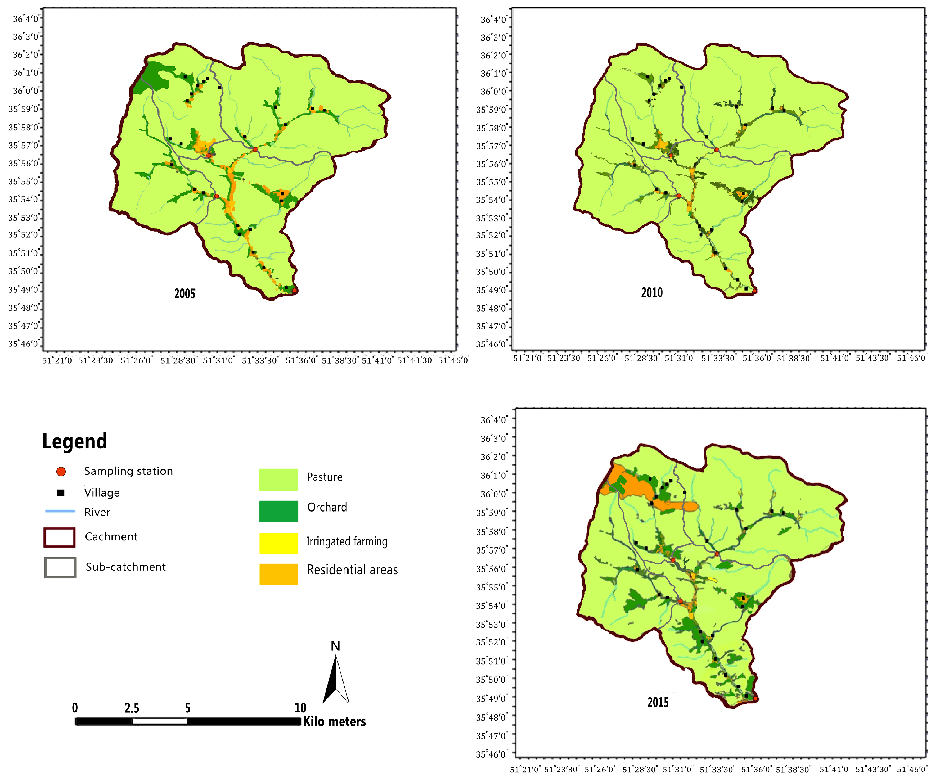
2.1. Study Area
2.2. Water Quality Data and Land Use Status
2.3. Data Analysis
3. Results
3.1. Descriptive Analysis
3.2. Regression Results
3.3. Sensitivity Analysis of Land Use Change and Water Quality
4. Discussion
5. Conclusions
Author Contributions
Funding
Data Availability Statement
Acknowledgments
Conflicts of Interest
References
- Duan, W.; He, B.; Nover, D.; Yang, G.; Chen, W.; Meng, H.; Zou, S.; Liu, C. Water quality assessment and pollution source identification of the eastern Poyang Lake Basin using multivariate statistical methods. Sustainability 2016, 8, 133. [Google Scholar] [CrossRef] [Green Version]
- Ni, X.; Parajuli, P.B.; Ouyang, Y.; Dash, P.; Siegert, C. Assessing land use change impact on stream discharge and stream water quality in an agricultural watershed. Catena 2021, 198, 105055. [Google Scholar]
- Esfandeh, S.; Danehkar, A.; Salmanmahiny, A.; Sadeghi, S.M.M.; Marcu, M.V. Climate Change Risk of Urban Growth and Land Use/Land Cover Conversion: An In-Depth Review of the Recent Research in Iran. Sustainability 2021, 14, 338. [Google Scholar] [CrossRef]
- Tong, S.T.; Sun, Y.; Ranatunga, T.; He, J.; Yang, Y.J. Predicting plausible impacts of sets of climate and land use change scenarios on water resources. Appl. Geogr. 2012, 32, 477–489. [Google Scholar] [CrossRef]
- Daba, M.H.; You, S. Quantitatively assessing the future land-use/land-cover changes and their driving factors in the upper stream of the Awash River based on the CA–markov model and their implications for water resources management. Sustainability 2022, 14, 1538. [Google Scholar] [CrossRef]
- Ding, J.; Jiang, Y.; Fu, L.; Liu, Q.; Peng, Q.; Kang, M. Impacts of land use on surface water quality in a subtropical River Basin: A case study of the Dongjiang River Basin, Southeastern China. Water 2015, 7, 4427–4445. [Google Scholar] [CrossRef] [Green Version]
- Wijesiri, B.; Deilami, K.; Goonetilleke, A. Evaluating the relationship between temporal changes in land use and resulting water quality. Environ. Pollut. 2018, 234, 480–486. [Google Scholar] [CrossRef]
- Tong, S.T.; Chen, W. Modeling the relationship between land use and surface water quality. J. Environ. Manag. 2002, 66, 377–393. [Google Scholar] [CrossRef]
- Chotpantarat, S.; Boonkaewwan, S. Impacts of land-use changes on watershed discharge and water quality in a large intensive agricultural area in Thailand. Hydrol. Sci. J. 2018, 63, 1386–1407. [Google Scholar] [CrossRef]
- United Nations (UN). ‘Water-Related Diseases Responsible for 80 per Cent of All Illnesses, Deaths in Developing World’, Says Secretary-General in Environment Day Message. Available online: https://press.un.org/en/2003/sgsm8707.doc.htm (accessed on 8 October 2022).
- Kapembo, M.L.; Mukeba, F.B.; Sivalingam, P.; Mukoko, J.B.; Bokolo, M.K.; Mulaji, C.K.; Mpiana, P.T.; Poté, J.W. Survey of water supply and assessment of groundwater quality in the suburban communes of Selembao and Kimbanseke, Kinshasa in Democratic Republic of the Congo. Sustain. Water Resour. Manag. 2022, 8, 1–13. [Google Scholar]
- Morote, Á.F.; Olcina, J.; Hernández, M. The use of non-conventional water resources as a means of adaptation to drought and climate change in Semi-Arid Regions: South-Eastern Spain. Water 2019, 11, 93. [Google Scholar] [CrossRef] [Green Version]
- Sun, Z.; Long, D.; Yang, W.; Li, X.; Pan, Y. Reconstruction of GRACE data on changes in total water storage over the global land surface and 60 basins. Water Resour. Res. 2020, 56, e2019WR026250. [Google Scholar] [CrossRef]
- Olsen, R.L.; Chappell, R.W.; Loftis, J.C. Water quality sample collection, data treatment and results presentation for principal components analysis–literature review and Illinois River watershed case study. Water Res. 2012, 46, 3110–3122. [Google Scholar] [CrossRef] [PubMed]
- Montazeralzohour, M.; Ziyarani, E.; Malmasi, S.; Rafati, M. River water quality assessment using WRASTIC and organizing methods: A case study in three subwatersheds of Karaj River (Varangeh Rud, Doab, and Varian). In Proceedings of the 4th International Congress of Developing Agriculture, Natural Resources, Environment and Tourism of Iran, Tabriz, Iran, 21 January 2019. [Google Scholar]
- de Mello, K.; Taniwaki, R.H.; de Paula, F.R.; Valente, R.A.; Randhir, T.O.; Macedo, D.R.; Leal, C.G.; Rodrigues, C.B.; Hughes, R.M. Multiscale land use impacts on water quality: Assessment, planning, and future perspectives in Brazil. J. Environ. Manag. 2020, 270, 110879. [Google Scholar] [CrossRef]
- Hu, H.B.; Liu, H.Y.; Hao, J.F.; An, J. Analysis of Land Use Change Characteristics Based on Remote Sensing and Gis in the Jiuxiang River Watershed. Int. J. Smart Sens. Intell. Syst. 2012, 5, 811–823. [Google Scholar] [CrossRef] [Green Version]
- Rawat, J.; Kumar, M. Monitoring land use/cover change using remote sensing and GIS techniques: A case study of Hawalbagh block, district Almora, Uttarakhand, India. Egypt. J. Remote. Sens. Space Sci. 2015, 18, 77–84. [Google Scholar] [CrossRef] [Green Version]
- Hua, A.K. Land use land cover changes in detection of water quality: A study based on remote sensing and multivariate statistics. J. Environ. Public Health 2017, 7515130. [Google Scholar] [CrossRef] [Green Version]
- Du Plessis, A.; Harmse, T.; Ahmed, F. Quantifying and predicting the water quality associated with land cover change: A case study of the Blesbok Spruit Catchment, South Africa. Water 2014, 6, 2946–2968. [Google Scholar] [CrossRef] [Green Version]
- Li, Y.; Bi, Y.; Mi, W.; Xie, S.; Ji, L. Land-use change caused by anthropogenic activities increase fluoride and arsenic pollution in groundwater and human health risk. J. Hazard. Mater. 2021, 406, 124337. [Google Scholar] [CrossRef]
- Liu, J.; Cheng, F.; Zhu, Y.; Zhang, Q.; Song, Q.; Cui, X. Urban Land-Use Type Influences Summertime Water Quality in Small-and Medium-Sized Urban Rivers: A Case Study in Shanghai, China. Land 2022, 11, 511. [Google Scholar] [CrossRef]
- Vrebos, D.; Beauchard, O.; Meire, P. The impact of land use and spatial mediated processes on the water quality in a river system. Sci. Total. Environ. 2017, 601, 365–373. [Google Scholar] [CrossRef] [PubMed]
- Zhang, F.; Chen, Y.; Wang, W.; Jim, C.Y.; Zhang, Z.; Tan, M.L.; Liu, C.; Chan, N.W.; Wang, D.; Wang, Z.; et al. Impact of land-use/land-cover and landscape pattern on seasonal in-stream water quality in small watersheds. J. Clean. Prod. 2022, 357, 131907. [Google Scholar] [CrossRef]
- Hosseinabadi, F.; Hashemi, S.H.; Abdoli, A.; Mehrjo, F. Development of multimetric index based on benthic macroinvertebrate for water quality assessment of Jajrood River in Iran. Casp. J. Environ. Sci. 2022, 20, 77–88. [Google Scholar]
- Su, F.; Kaplan, D.; Li, L.; Li, H.; Song, F.; Liu, H. Identifying and classifying pollution hotspots to guide watershed management in a large multiuse watershed. Int. J. Environ. Res. Public Health 2017, 14, 260. [Google Scholar] [CrossRef] [PubMed] [Green Version]
- Xue, J.; Wang, Q.; Zhang, M. A review of non-point source water pollution modeling for the urban–rural transitional areas of China: Research status and prospect. Sci. Total. Environ. 2022, 826, 154146. [Google Scholar] [CrossRef]
- Karamouz, M.; Teymoori, J.; Olyaei, M. A Spatial Non-Stationary Based Site Selection of Artificial Groundwater Recharge: A Case Study for Semi-Arid Regions. Water Resour. Manag. 2021, 35, 963–978. [Google Scholar] [CrossRef]
- Kawagoshi, Y.; Suenaga, Y.; Chi, N.L.; Hama, T.; Ito, H.; Van Duc, L. Understanding nitrate contamination based on the relationship between changes in groundwater levels and changes in water quality with precipitation fluctuations. Sci. Total. Environ. 2019, 657, 146–153. [Google Scholar] [CrossRef]
- Hakimi, L.; Sadeghi, S.M.M.; Van Stan, J.T.; Pypker, T.G.; Khosropour, E. Management of pomegranate (Punica granatum) orchards alters the supply and pathway of rain water reaching soils in an arid agricultural landscape. Agric. Ecosyst. Environ. 2018, 259, 77–85. [Google Scholar] [CrossRef]
- Rostammiri, A.; Malmasi, S.; Yosefvand, F.; Hoseini, S.A.; Etminan, A. Presenting the spatial–temporal model for assessing and predicting qualitative changes of the groundwater resources in Shahriar, Tehran, Iran. Environ. Monit. Assess. 2022, 194, 1–12. [Google Scholar] [CrossRef]
- Razmkhah, H.; Abrishamchi, A.; Torkian, A. Evaluation of spatial and temporal variation in water quality by pattern recognition techniques: A case study on Jajrood River (Tehran, Iran). J. Environ. Manag. 2010, 91, 852–860. [Google Scholar] [CrossRef]
- Shayeghi, M.; Vatandoost, H.; Paksa, A.; Amin, M.; Yousefi, H.; Rahimi, S.; Abbasi, M.; Akhavan, A.A. Identification of common aquatic insects of Jajroud river. J. Entomol. Zool Stud. 2017, 5, 1433–1436. [Google Scholar]
- Allahdad, Z.; Arjmandi, R.; Hassani, A.; Vafaeinezhad, A.; Malmasi, S. Estimation of drinking water quality parameters changes in response to land use changes. Bulg. Chem. Commun. 2017, 49, 335–340. [Google Scholar]
- Souri, L. Evaluation Factors Affecting of Vulner Ability the Quality of Groundwater and Drinking Wells in Pardis. Master’s Thesis, Tehran University, Tehran, Iran, 2017. [Google Scholar]
- Givi, M.; Jahangiri-Rad, M.; Tashauoei, H. Assessment of Groundwater Quality in the Jajrood River Basin, Tehran, Iran: A Coupled Physicochemical and Hydrogeochemical Study. J. Adv. Environ. Health Res. 2021, 9, 237–254. [Google Scholar] [CrossRef]
- Water Resources Research Center (TAMAB). Available online: https://www.wrm.ir/?l=EN (accessed on 30 July 2022).
- Institute of Standards & Industrial Research of Iran (ISIRI). Available online: http://www.isiri.com/ (accessed on 30 July 2022).
- Apha, A. WEF, Standard Methods for the Examination of Water and Wastewater, 18th ed.; American Public Health Association: Washington, DC, USA, 1992. [Google Scholar]
- Menon, S. ArcGIS 10.3: The Next Generation of GIS Is Here. Available online: https://www.esri.com/arcgis-blog/products/3d-gis/3d-gis/arcgis-10-3-the-next-generation-of-gis-is-here/ (accessed on 30 July 2022).
- Nasiri, V.; Deljouei, A.; Moradi, F.; Sadeghi, S.M.M.; Borz, S.A. Land Use and Land Cover Mapping Using Sentinel-2, Landsat-8 Satellite Images, and Google Earth Engine: A Comparison of Two Composition Methods. Remote. Sens. 2022, 14, 1977. [Google Scholar] [CrossRef]
- Ghalegolab, B.A.; Khoshbakht, K.; Tabrizi, L.; Davari, A.; Vaisi, H. A Comparative Assessment of Agrobiodiversity Indices in Farms, Gardens and Home Gardens (Case Study: Of Jajrood Basin); AGROECOLOGY-Boomshenasi Keshavarzi: Mashhad, Iran, 2013. [Google Scholar]
- Mirzaei, M.; Hasanian, H. Quality Evaluation of Jajrood River (IRAN) by Quality Indices Methods. Adv. Mater. Res. 2013, 650, 652–657. [Google Scholar] [CrossRef]
- IBM SPSS Statistics 24. 2021. Available online: https://www.ibm.com/support/pages/downloading-ibm-spss-statistics-24 (accessed on 30 July 2022).
- Attarod, P.; Kheirkhah, F.; Khalighi Sigaroodi, S.; Sadeghi, S. Sensitivity of Reference Evapotranspiration to Glob al Warming in the Caspian Region, North of Iran. J. Agr. Sci. Tech. 2015, 17, 869–883. [Google Scholar]
- Shah, M.I.; Javed, M.F.; Abunama, T. Proposed formulation of surface water quality and modelling using gene expression, machine learning, and regression techniques. Environ. Sci. Pollut. Res. 2021, 28, 13202–13220. [Google Scholar] [CrossRef]
- Donohue, I.; McGarrigle, M.L.; Mills, P. Linking catchment characteristics and water chemistry with the ecological status of Irish rivers. Water Res. 2006, 40, 91–98. [Google Scholar] [CrossRef]
- Huang, J.; Li, Q.; Pontius, R.G.; Klemas, V.; Hong, H. Detecting the dynamic linkage between landscape characteristics and water quality in a subtropical coastal watershed, Southeast China. Environ. Manag. 2013, 51, 32–44. [Google Scholar] [CrossRef]
- Baoying, N.; Yuanqing, H. Tourism development and water pollution: Case study in Lijiang Ancient Town. China Popul. Resour. Environ. 2007, 17, 123–127. [Google Scholar] [CrossRef]
- Jóźwiakowski, K.; Listosz, A.; Gizińska-Górna, M.; Pytka, A.; Marzec, M.; Sosnowska, B.; Kowalczyk-Juśko, A.; Grzywna, A.; Mazur, A.; Obroślak, R. Effect of Anthropogenic Pollutants on the Quality of Surface Waters Aand Groundwaters in the Catchment Basin of Lake Bialskie. J. Ecol. Eng. 2016, 17, 154–162. [Google Scholar] [CrossRef] [Green Version]
- Bahroun, S.; Chaib, W. The quality of surface waters of the dam reservoir Mexa, Northeast of Algeria. J. Water Land Dev. 2017, 34, 11–19. [Google Scholar] [CrossRef]
- Wang, R.; Kalin, L. Combined and synergistic effects of climate change and urbanization on water quality in the Wolf Bay watershed, southern Alabama. J. Environ. Sci. 2018, 64, 107–121. [Google Scholar] [CrossRef] [PubMed]
- Rimba, A.B.; Mohan, G.; Chapagain, S.K.; Arumansawang, A.; Payus, C.; Fukushi, K.; Osawa, T.; Avtar, R.; Husnayaen. Impact of population growth and land use and land cover (LULC) changes on water quality in tourism-dependent economies using a geographically weighted regression approach. Environ. Sci. Pollut. Res. 2021, 28, 25920–25938. [Google Scholar] [CrossRef] [PubMed]
- Schilling, K.E.; Spooner, J. Effects of watershed-scale land use change on stream nitrate concentrations. J. Environ. Qual. 2006, 35, 2132–2145. [Google Scholar] [CrossRef]
- Brontowiyono, W.; Asmara, A.A.; Jana, R.; Yulianto, A.; Rahmawati, S. Land-Use Impact on Water Quality of the Opak Sub-Watershed, Yogyakarta, Indonesia. Sustainability 2022, 14, 4346. [Google Scholar] [CrossRef]
- Camara, M.; Jamil, N.R.; Abdullah, A.F.B. Impact of land uses on water quality in Malaysia: A review. Ecol. Process. 2019, 8, 1–10. [Google Scholar] [CrossRef]
- Park, S.R.; Kim, S.; Lee, S.W. Evaluating the Relationships between Riparian land cover characteristics and biological integrity of streams using Random Forest algorithms. Int. J. Environ. Res. Public Health 2021, 18, 3182. [Google Scholar] [CrossRef]
- Wang, B.; Zheng, X.; Zhang, H.; Xiao, F.; Gu, H.; Zhang, K.; He, Z.; Liu, X.; Yan, Q. Bacterial community responses to tourism development in the Xixi National Wetland Park, China. Sci. Total. Environ. 2020, 720, 137570. [Google Scholar] [CrossRef]
- Winton, R.S.; Teodoru, C.R.; Calamita, E.; Kleinschroth, F.; Banda, K.; Nyambe, I.; Wehrli, B. Anthropogenic influences on Zambian water quality: Hydropower and land-use change. Environ. Sci. Process. Impacts 2021, 23, 981–994. [Google Scholar] [CrossRef]
- Keesstra, S.D.; Geissen, V.; Mosse, K.; Piiranen, S.; Scudiero, E.; Leistra, M.; van Schaik, L. Soil as a filter for groundwater quality. Curr. Opin. Environ. Sustain. 2012, 4, 507–516. [Google Scholar] [CrossRef]
- Pérez-Fernández, M.A.; Calvo-Magro, E.; Valentine, A. Benefits of the symbiotic association of shrubby legumes for the rehabilitation of degraded soils under Mediterranean climatic conditions. Land Degrad. Dev. 2016, 27, 395–405. [Google Scholar] [CrossRef]
- Tanaka, Y.; Minggat, E.; Roseli, W. The impact of tropical land-use change on downstream riverine and estuarine water properties and biogeochemical cycles: A review. Ecol. Process. 2021, 10, 1–21. [Google Scholar] [CrossRef]
- Gong, X.; Bian, J.; Wang, Y.; Jia, Z.; Wan, H. Evaluating and predicting the effects of land use changes on water quality using SWAT and CA–Markov models. Water Resour. Manag. 2019, 33, 4923–4938. [Google Scholar] [CrossRef]
- Luo, Z.; Shao, Q.; Zuo, Q.; Cui, Y. Impact of land use and urbanization on river water quality and ecology in a dam dominated basin. J. Hydrol. 2020, 584, 124655. [Google Scholar] [CrossRef]
- Rahbarisisakht, S.; Moayeri, M.H.; Hayati, E.; Sadeghi, S.M.M.; Kepfer-Rojas, S.; Pahlavani, M.H.; Kappel Schmidt, I.; Borz, S.A. Changes in Soil’s Chemical and Biochemical Properties Induced by Road Geometry in the Hyrcanian Temperate Forests. Forests 2021, 12, 1805. [Google Scholar] [CrossRef]
- Wu, L.; Qi, T.; Zhang, J. Spatiotemporal variations of adsorbed nonpoint source nitrogen pollution in a highly erodible Loess Plateau watershed. Pol. J. Environ. Stud. 2017, 26, 1343–1352. [Google Scholar] [CrossRef]
- Zhan, J.; Chu, X.; Li, Z.; Jia, S.; Wang, G. Incorporating ecosystem services into agricultural management based on land use/cover change in Northeastern China. Technol. Forecast. Soc. Chang. 2019, 144, 401–411. [Google Scholar] [CrossRef]
- Rocha, K.F.; Mariano, E.; Grassmann, C.S.; Trivelin, P.C.; Rosolem, C.A. Fate of 15N fertilizer applied to maize in rotation with tropical forage grasses. Field Crop. Res. 2019, 238, 35–44. [Google Scholar] [CrossRef]
- Sadeghi, S.M.M.; Gordon, D.A.; Van Stan, J.T., II. A global synthesis of throughfall and stemflow hydrometeorology. In Precipitation Partitioning by Vegetation; Springer: Berlin/Heidelberg, Germany, 2020; pp. 49–70. [Google Scholar]
- Anand, J.; Gosain, A.K.; Khosa, R. Prediction of land use changes based on Land Change Modeler and attribution of changes in the water balance of Ganga basin to land use change using the SWAT model. Sci. Total. Environ. 2018, 644, 503–519. [Google Scholar] [CrossRef]
- Kiage, L.M.; Douglas, P. Linkages between land cover change, lake shrinkage, and sublacustrine influence determined from remote sensing of select Rift Valley Lakes in Kenya. Sci. Total. Environ. 2020, 709, 136022. [Google Scholar] [CrossRef] [PubMed]
- Bu, H.; Meng, W.; Zhang, Y.; Wan, J. Relationships between land use patterns and water quality in the Taizi River basin, China. Ecol. Indic. 2014, 41, 187–197. [Google Scholar] [CrossRef]
- Nafi’Shehab, Z.; Jamil, N.R.; Aris, A.Z.; Shafie, N.S. Spatial variation impact of landscape patterns and land use on water quality across an urbanized watershed in Bentong, Malaysia. Ecol. Indic. 2021, 122, 107254. [Google Scholar]
- Petersen, C.R.; Jovanovic, N.Z.; Le Maitre, D.C.; Grenfell, M. Effects of land use change on streamflow and stream water quality of a coastal catchment. Water SA 2017, 43, 139–152. [Google Scholar] [CrossRef] [Green Version]
- El-Gammal, M.; Ibrahim, M.; Gad, A.; El-Zeiny, A. Integration of lab analyses and GIS techniques for assessment of some physical and chemical characteristics in different water bodies, Damietta coastal region, Egypt. Mansoura J. Environ. Sci. 2015, 44, 257–284. [Google Scholar]
- Alnagaawy, A.; Sherif, M.; Mohammed, G.; Shehata, A. Impact of industrial pollutants on some water quality parameters of Edku, Mariout lakes and the Nile River. Int. J. Environ. 2018, 7, 1–15. [Google Scholar]
- Kadir, A.; Ahmed, Z.; Uddin, M.M.; Xie, Z.; Kumar, P. Integrated Approach to Quantify the Impact of Land Use and Land Cover Changes on Water Quality of Surma River, Sylhet, Bangladesh. Water 2021, 14, 17. [Google Scholar] [CrossRef]
- Putri, A.; Jana, R.; Florensia, A.; Asmara, A.; Yulianto, A.; Brontowiyono, W. A Spatiotemporal Analysis of Water Quality and Land Use in Tambayakbayan River, Yogyakarta; IOP Conference Series: Earth and Environmental Science; IOP Publishing: Bristol, UK, 2021; Volume 933, p. 012045. [Google Scholar]
- Adeola Fashae, O.; Abiola Ayorinde, H.; Oludapo Olusola, A.; Oluseyi Obateru, R. Landuse and surface water quality in an emerging urban city. Appl. Water Sci. 2019, 9, 1–12. [Google Scholar] [CrossRef] [Green Version]
- Maurya, P.K.; Ali, S.A.; Alharbi, R.S.; Yadav, K.K.; Alfaisal, F.M.; Ahmad, A.; Ditthakit, P.; Prasad, S.; Jung, Y.K.; Jeon, B.H. Impacts of Land Use Change on Water Quality Index in the Upper Ganges River near Haridwar, Uttarakhand: A GIS-Based Analysis. Water 2021, 13, 3572. [Google Scholar] [CrossRef]
- Lee, S.W.; Hwang, S.J.; Lee, S.B.; Hwang, H.S.; Sung, H.C. Landscape ecological approach to the relationships of land use patterns in watersheds to water quality characteristics. Landsc. Urban Plan. 2009, 92, 80–89. [Google Scholar] [CrossRef]
- Attua, E.M.; Ayamga, J.; Pabi, O. Relating land use and land cover to surface water quality in the Densu River basin, Ghana. Int. J. River Basin Manag. 2014, 12, 57–68. [Google Scholar] [CrossRef]


| Sub Catchments | Area (ha) |
|---|---|
| Rooteh | 15,579.7 |
| Meygoon | 7124.4 |
| Ahar | 9266.8 |
| Central Latyan | 13,420.1 |
| Total | 45,390.9 |
| Sampling Stations | Time Intervals (Year) | pH | TDS (mg/L) | Na+ (mg/L) | Mg+ (mg/L) | Ca+ (mg/L) | SO42− (mg/L) | Cl− (mg/L) | NO3− (mg/L) |
|---|---|---|---|---|---|---|---|---|---|
| Rooteh | 2005–2000 | 8.04 | 114.18 | 0.19 | 0.73 | 1.58 | 0.56 | 0.15 | 4.40 |
| 2010–2005 | 7.91 | 152.81 | 0.16 | 0.56 | 1.96 | 0.59 | 0.22 | 4.32 | |
| 2015–2010 | 8.19 | 147.52 | 0.23 | 0.67 | 1.79 | 0.62 | 0.22 | 4.32 | |
| Meygoon | 2005–2000 | 7.80 | 317.93 | 1.25 | 1.71 | 2.28 | 1.46 | 0.72 | 4.00 |
| 2010–2005 | 7.85 | 383.97 | 1.67 | 1.67 | 3.35 | 1.97 | 1.16 | 4.60 | |
| 2015–2010 | 7.86 | 319.96 | 1.17 | 1.62 | 2.78 | 1.49 | 0.81 | 4.44 | |
| Ahar | 2005–2000 | 7.78 | 3136.77 | 32.15 | 9.61 | 9.46 | 29.83 | 17.00 | 3.40 |
| 2010–2005 | 7.61 | 4912.89 | 45.34 | 15.28 | 9.93 | 35.73 | 27.44 | 3.60 | |
| 2015–2010 | 7.64 | 2172.50 | 17.88 | 6.63 | 7.73 | 16.37 | 10.16 | 4.44 | |
| Central Latyan | 2005–2000 | 7.85 | 216.13 | 0.47 | 0.86 | 2.35 | 0.78 | 0.46 | 3.14 |
| 2010–2005 | 7.86 | 196.26 | 0.37 | 0.76 | 2.38 | 0.75 | 0.33 | 4.40 | |
| 2015–2010 | 8.07 | 206.46 | 0.56 | 0.83 | 2.35 | 0.89 | 0.46 | 5.10 | |
| Jajrood Catchment | 2005–2000 | 7.87 | 953.75 | 8.52 | 3.23 | 3.92 | 8.16 | 4.58 | 3.74 |
| 2010–2005 | 7.81 | 1411.48 | 11.89 | 4.59 | 4.40 | 9.76 | 7.29 | 4.10 | |
| 2015–2010 | 7.94 | 711.61 | 4.96 | 2.44 | 3.66 | 4.84 | 2.91 | 4.58 |
| Sub-Catchments | Land Use | Year | The Trend of Changes in | ||||||
|---|---|---|---|---|---|---|---|---|---|
| 2005 | 2010 | 2015 | Land Use Area (ha) | ||||||
| Area (ha) | Area (%) | Area (ha) | Area (%) | Area (ha) | Area (%) | 2005–2010 | 2010–2015 | ||
| Rooteh | Orchard | 471.8 | 3 | 513 | 3.3 | 479 | 3.1 | Increasing 41.2 | Decreasing 34.0 |
| Irrigated Farming | 33.3 | 0.2 | 2.5 | 0 | 70.7 | 0.5 | Decreasing 30.9 | Increasing 68.2 | |
| Pastures | 15,048.9 | 96.6 | 15,000.1 | 96.3 | 14,854.4 | 95.3 | Decreasing 48.8 | Decreasing 145.7 | |
| Residential Areas | 25.6 | 0.2 | 64.1 | 0.4 | 175.6 | 1.1 | Increasing 38.5 | Increasing 111.5 | |
| Sum | 15,579.7 | 100 | 15,579.7 | 100 | 15,579.7 | 100 | - | - | |
| Meygoon | Orchard | 1192.7 | 16.7 | 881.7 | 12.4 | 495.5 | 7 | Decreasing 311.0 | Decreasing 386.3 |
| Irrigated Farming | 16.9 | 0.2 | 5 | 0.1 | 3.4 | 0 | Decreasing 11.9 | Decreasing 1.6 | |
| Pastures | 5564.5 | 78.2 | 5567.6 | 78.1 | 5514.7 | 77.4 | Decreasing 3.0 | Decreasing 52.8 | |
| Residential Areas | 350.3 | 4.9 | 670.1 | 9.4 | 1110.8 | 15.6 | Increasing 319.9 | Increasing 440.7 | |
| Sum | 7124.4 | 100 | 7124.4 | 100 | 7124.4 | 100 | - | - | |
| Ahar | Orchard | 463.4 | 5 | 574.2 | 6.2 | 781.4 | 8.4 | Increasing 110.8 | Increasing 207.2 |
| Irrigated Farming | 0 | 0 | 157.3 | 1.7 | 0 | 0 | Decreasing 157.3 | Decreasing 157.3 | |
| Pastures | 8787.9 | 94.8 | 8522.4 | 92 | 8367.5 | 90.3 | Decreasing 265.5 | Decreasing 154.9 | |
| Residential Areas | 15.4 | 0.2 | 12.9 | 0.1 | 117.9 | 1.3 | Decreasing 2.6 | Increasing 105.1 | |
| Sum | 9266.8 | 100 | 9266.8 | 100 | 9266.8 | 100 | - | - | |
| Central Latyan | Orchard | 1959.2 | 15 | 1350 | 10 | 1089 | 8 | Decreasing 609.3 | Decreasing 261.0 |
| Irrigated Farming | 76.8 | 1 | 3 | 0 | 1 | 0 | Decreasing 73.8 | Decreasing 2.0 | |
| Pastures | 11,272.8 | 83 | 11,969.9 | 89 | 12,059.9 | 90 | Increasing 697.1 | Increasing 89.9 | |
| Residential Areas | 111.3 | 1 | 97.2 | 1 | 270.2 | 2 | Decreasing 14.1 | Increasing 173.0 | |
| Sum | 13,420.1 | 100 | 13,420.1 | 100 | 13,420.1 | 100 | - | - | |
| Jajrood Catchment | Orchard | 4087.2 | 9 | 3318.9 | 7.3 | 2844.8 | 6.3 | Decreasing 768.3 | Decreasing 474.1 |
| Irrigated Farming | 127 | 0.3 | 167.8 | 0.4 | 75.1 | 0.2 | Increasing 40.8 | Decreasing 92.7 | |
| Pastures | 40,574.1 | 89.4 | 41,060 | 90.5 | 40,996.4 | 90.3 | Increasing 485.8 | Decreasing 63.6 | |
| Residential Areas | 602.7 | 1.3 | 844.3 | 1.9 | 1474.6 | 3.2 | Increasing 241.6 | Increasing 630.3 | |
| Sum | 45,390.9 | 100 | 45,390.9 | 100 | 45,390.9 | 100 | - | - | |
| Multivariate Regression Model | Independent Variables * | Dependent Variable | R2 | p-Value |
|---|---|---|---|---|
| pH = −16.758 + 0.101 PA + 0.085 RA | PA, RA | pH | 0.884 | 0.012 |
| TDS = −57,018.252 + 654.820 PA − 437.620 RA | PA, RA | TDS | 0.836 | 0.018 |
| Cl− = −346.607 + 3.968 PA − 2.759 RA | PA, RA | Cl− | 0.812 | 0.023 |
| SO42− = −277.802 + 3.246 PA − 3.285 RA | PA, RA | SO42− | 0.809 | 0.023 |
| NO3−=−7.145 + 0.116 PA + 0.387 RA | PA, RA | NO3− | 0.766 | 0.035 |
| Na+ = −314.598 + 3.627 PA − 2.950 RA | PA, RA | Na+ | 0.790 | 0.025 |
| Mg+ = −171.392 + 1.973 PA − 1.350 RA | PA, RA | Mg+ | 0.774 | 0.033 |
| Ca+ = −57.077 + 0.689 PA − 0.463 RA | PA, RA | Ca+ | 0.800 | 0.024 |
| Permissible Area of Pasture (ha) | Permissible Area of Pasture (%) | Permissible Area of Residential Areas (ha) | Permissible Area of Residential Areas (%) | Water Quality Permissible Limit (mg/ L) | Multivariate Regression Model |
|---|---|---|---|---|---|
| 1471.3 | 9.92 | 79.5 | −10.34 | 6.5–9 | pH = −16.758 + 0.101 PA + 0.085 RA |
| 1074.8 | 7.25 | 86.92 | −11.3 | 1500 | TDS = −57,018.252 + 654.820 PA − 437.620 RA |
| 1213.5 | 8.19 | −11.23 | 1.46 | 400 | Cl− = −346.607 + 3.968 PA − 2.759 RA |
| 1691.7 | 11.41 | −34.22 | 4.45 | 400 | SO42− = −277.802 + 3.246 PA - 3.285 RA |
| 5412.2 | 36.51 | 34.2 | −4.45 | 50 | NO3− = −7.145 + 0.116 PA + 0.387 RA |
| 1341.2 | 9.05 | 73.85 | −9.6 | 200 | Na+ = −314.598 + 3.627 PA − 2.950 RA |
| 1111.1 | 7.49 | −516.1 | 67.11 | 30 | Mg+ = −171.392 + 1.973 PA - 1.350 RA |
| 1509.2 | 10.18 | −481.95 | 62.67 | 300 | Ca+ = −57.077 + 0.689 PA − 0.463 RA |
| Water Quality Parameters | Values of Water Quality Parameters for Residential Areas Change (mg/L) | Values of Water Quality Parameters for Pastures Area Change (mg/L) |
|---|---|---|
| pH | 8.7 | 7.0 |
| TDS | 3139.4 | 6408.5 |
| Cl− | 21.4 | 37.4 |
| SO42− | 22.5 | 34.8 |
| NO3− | 8.0 | 3.1 |
| Na+ | 22.5 | 35.0 |
| Mg+ | 9.4 | 19.6 |
| Ca+ | 0.4 | 9.7 |
Publisher’s Note: MDPI stays neutral with regard to jurisdictional claims in published maps and institutional affiliations. |
© 2022 by the authors. Licensee MDPI, Basel, Switzerland. This article is an open access article distributed under the terms and conditions of the Creative Commons Attribution (CC BY) license (https://creativecommons.org/licenses/by/4.0/).
Share and Cite
Allahdad, Z.; Malmasi, S.; Montazeralzohour, M.; Sadeghi, S.M.M.; Khabbazan, M.M. Presenting the Spatio-Temporal Model for Predicting and Determining Permissible Land Use Changes Based on Drinking Water Quality Standards: A Case Study of Northern Iran. Resources 2022, 11, 103. https://doi.org/10.3390/resources11110103
Allahdad Z, Malmasi S, Montazeralzohour M, Sadeghi SMM, Khabbazan MM. Presenting the Spatio-Temporal Model for Predicting and Determining Permissible Land Use Changes Based on Drinking Water Quality Standards: A Case Study of Northern Iran. Resources. 2022; 11(11):103. https://doi.org/10.3390/resources11110103
Chicago/Turabian StyleAllahdad, Zahra, Saeed Malmasi, Morvarid Montazeralzohour, Seyed Mohammad Moein Sadeghi, and Mohammad M. Khabbazan. 2022. "Presenting the Spatio-Temporal Model for Predicting and Determining Permissible Land Use Changes Based on Drinking Water Quality Standards: A Case Study of Northern Iran" Resources 11, no. 11: 103. https://doi.org/10.3390/resources11110103