Article

Return to Nature: Renaturisation of Dried-Out Lakes in Poland

1
Department of Hydrology and Water Management, Adam Mickiewicz University, Krygowskiego 10, 61-680 Poznan, Poland
2
Agronomy Department, Hydraulics Division, Faculty of Science, University 20 Août 1955 Skikda, Route El Hadaik, BP 26, Skikda 21000, Algeria
3
College of Hydraulic Science and Engineering, Yangzhou University, Yangzhou 225009, China
4
Department of Land Improvement, Environmental Development and Spatial Management, Poznań University of Life Sciences, Piątkowska 94E, 60-649 Poznan, Poland
*
Author to whom correspondence should be addressed.
Resources 2023, 12(12), 137; https://doi.org/10.3390/resources12120137
Submission received: 11 October 2023 / Revised: 14 November 2023 / Accepted: 16 November 2023 / Published: 21 November 2023

Abstract

:
Over the centuries, extensive changes have occurred in the functioning of the hydrosphere. In the case of Poland, the hydrographic network has been significantly transformed, and many of its elements have ceased to exist. The aim of this study was to investigate renaturalised lakes and to determine their original volume, which is a fundamental parameter in the context of stabilising water relationships. Based on archival cartographic materials, the locations of 15 such lakes were determined, with their volume totaling 11.7 million m3. This indicates a significant potential for renaturalised lakes in the context of increasing water resources. In the long term, the methodology adopted in this work may complement water-management efforts aimed at increasing retention and offering new ecosystem services. Such an approach is less invasive to the natural environment and more economically justified compared to new investments in artificial hydrotechnical infrastructure.

1. Introduction

The environment surrounding humans is subject to continuous transformation. This general statement covers a number of detailed processes referring to particular spheres. Changes in the natural and anthropogenic character are evident in reference to the hydrosphere. The human role is of particular importance here, due to the centuries-long interference in the hydrographic network for the purpose of using water for our own needs [1,2,3,4]. Water circulation is being modified by people on a previously unencountered scale, and at an exceptional rate [5]. Water management is generally implemented in two basic directions—water drainage or water retention. Examples from various regions around the globe show that the scale of transformation of elements of the hydrographic network is highly variable, and closely dependent on human activity. An increase in water uptake due to an increase in population size and intensified agricultural activity was the primary reason for the water deficit in Iran [6]. In the case of the Lotter Beeke catchment, which was intensively drained over decades, a simulation of an increase in groundwater level up to 35 cm was conducted, suggesting a future decrease in the need for irrigation, and minimisation of conflicts related to water use [7].
Intensive and unregulated anthropogenic activities result in the disturbance of the natural physicochemical parameters of water bodies and a reduction in biodiversity [8]. In reference to one of the elements of the hydrosphere (wetlands), Long et al. [9] pointed out that the incorporation of a relevant historical perspective into management and protection is important for an understanding of the ways in which the effects of ecological disasters can be mitigated. The amount of freshwater stored in rivers, wetlands, and lakes, as well as the changes in these levels, are vital elements of the water cycle. They are also of key importance in the management of water resources [10]. In the case of Poland, considerable changes in the components of the water balance, and particularly retention volume and time, occurred in the 18th and 19th century [11]. Maciak et al. [12] emphasise that the drying of larger areas only began to intensify in the second half and at the end of the 19th century, contributing to an increase in agricultural production.
The approach to water is currently essentially different to that of a hundred years ago. Water is increasingly becoming a deficit resource, to the point where there are conflicts over water access in different regions of the world [13,14]. Therefore, various activities aimed at ensuring sufficient water resources have been implemented. The most spectacular are works related to technical measures. The construction of numerous dam reservoirs has allowed for optimal water management. The general purposefulness and usefulness of retention reservoirs is undisputable, although their size and location are controversial [15]. Therefore, the current state of knowledge of natural elements of the environment that have been lost as a result of human activity should be expanded as much as possible. Renaturisation of components of the natural environment takes different forms and scales. According to Zerbe [16], the possibilities for rebuilding of ecosystems concern broadly defined technical measures as well as inaction (passive rebuilding). The growing deficit of water resources requires a long-term prevention programme including renaturisation of elements of the hydrosphere [17]. Water deficit has a negative effect on the natural environment, and creates barriers for development in all sectors of the national economy. Due to the above, all initiatives aimed at an increase in water resources, in terms of quantity, are extremely valuable, and should be treated as a priority in Poland [18].
These postulates correspond with the focus of this article, which aims to determine, for a long-term perspective, the primary water resources of renaturised Polish lakes that had previously dried out. The determination of the volume of restored lakes is a new approach, compared to earlier analyses where the study subject was only the determination of the place of restoration and surface area of such elements of the hydrosphere [19].

2. Materials and Methods
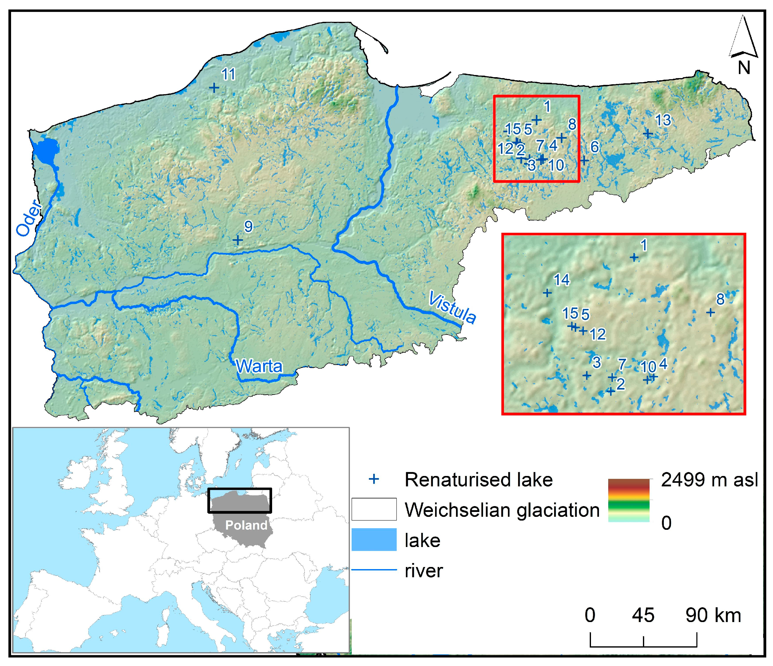
2.1. Study Area

This paper presents an analysis of the original volumes of 15 lakes that dried out in the 19th century through to the mid-20th century. Of the analysed lakes, 13 are located in north-east Poland, and the remaining 2 are in the north-west part of the country (Figure 1).

2.2. Materials

This study was based on German historical agronomic, geognostic–agronomic, and topographic maps from the late 19th century (1890–1897) and the first half of the 20th century (1902–1952). The maps were developed at a scale of 1:25,000. Historical topographic maps (Messtischblatt) were prepared in the Müffling polyhedral projection (“Prussian polyhedral projection”). The initial meridian for the coordinate system was the Ferro meridian (difference towards Greenwich of 17°40′). In 1927, the Gauss–Krüger projection was introduced. It applied the Bessel ellipsoid from 1841. The historical maps were obtained in the raster form in a *.jpg format. With their degree of detail and full carto-metricity, they have repeatedly provided the basis for retrospective research [20,21,22,23,24]. In the case of lakes, they were used to determine changes in surface area and volume. An analysis of over one hundred and sixty lakes in western Poland showed that over a period of 100 years, there was a reduction in their surface area of more than 11% [25]. The morphometry of two coastal lakes (Jamno and Bukowo) in the south of the Baltic Sea underwent significant changes in the years 1909–2012. Their surface area decreased by 7.7 and 13.6%, respectively, and their volume was smaller by 5.9 and 17.5%, respectively [26]. Similar studies concerning six lakes in the Wielkopolska-Kujawy lake district showed a decline in the surface area (12.2%) and volume (13.9%). This situation was caused by both natural (overgrowing, shallowing) and anthropogenic factors (changes in water levels) [27]. The historical maps document the effects of drainage works. In some cases, however, the documentation presented the state of a lake before drainage. An example of such a process is Lake Czarne (Figure 2a), which completely disappeared as a result of the conduction of melioration works by means of ditches (Figure 2b). After ceasing conservation work on the ditches, water returned to the analysed area (Figure 2c).
The analysis also employed modern topographic maps at a scale of 1:10,000. The first edition of the modern topographic maps was from the period 1973–1986. The maps were prepared in a local coordinate system, Polska-1965 (PL-1965). The PL-1965 coordinate system divides the territory of Poland into five independent projection zones. The analysed lakes were in zones II (EPSG:2172) and III (EPSG:2173), where Roussilhe quasi-stereographic projection was applied for the Krasowski ellipsoid. The most recent materials were orthophotomaps in colour (RGB) and black and white (B/W). The orthophotomaps were from the period from 1997 to 2022. Their spatial resolution was usually 0.25 and 0.5 m, although for Lakes Patryckie, Trackie, and Bogdańskie, orthophotomaps had a spatial resolution of 0.1 m. The obtained orthophotomaps were developed in the coordinate system Polska-1992 (PL-1992), which is uniform for the entire territory of Poland. The 1992 system (EPSG:2180) employs the Gauss–Krüger projection for the GRS-80 ellipsoid. This study also involved the development of a digital terrain model based on data from aerial laser scanning. The DEM was developed based on data obtained for the period from 2011 to 2018. The spatial resolution of the model was 1.0 m. The DEMs were in the coordinate system PL-1992. The historical maps were obtained from the Cartographic Archive of WNGiG UAM as digitised raster files *.jpg through the Mapster service (http://igrek.amzp.pl/, accessed on 1 August 2023). Modern topographic maps were read in ArcGIS 10.7 software using the wms service (https://mapy.geoportal.gov.pl/wss/service/img/guest/TOPO/MapServer/WMSServer, accessed on 2 August 2023). Orthophotomaps and DEMs were downloaded through the Geoportal service in the form of *.tif and *.grid files.

2.3. Methods

Because most of the obtained cartographic data, particularly the modern data, were processed in the local coordinate system PL-1992, the first stage of registration of the historical maps was in that coordinate system. Particular stages of the research procedure are presented in Figure 3.
The procedure of registration of maps in the coordinate system employed coordinates of the original cartographic grid. The registration in the coordinate system employed first-order polynomial transformation (affine transformation). Each map registered in the coordinate system was verified in terms of the root-mean-square-error value (RMSE) in ArcMAP 10.7.1. At the second stage, based on historical topographic maps presenting the initial situation, i.e., before the establishment of a system of draining ditches, manual vectorisation of the spatial range of the lake and limnic peats was performed (Figure 4a). Using the subsequent edition of archival topographic maps presenting the state after the implementation of draining ditches, the spatial range of the water table in the lake was vectorised (Figure 4b). Moreover, vectorisation of contour lines within the area of occurrence of the lake and limnic peats was conducted, ending with the contour line designating the edge of the basin (Figure 4c). The contour lines were ascribed ordinates with consideration of the fact that their interval in topographic maps is 1.25 m. The resulting material provided the basis for the development of 3D models of lake basins using the Topo to Raster function. Based on 3D models of lake basins, the potential water-retention volume was calculated. Finally, the produced 3D models of lake basins (Figure 5a) were integrated with the modern digital terrain model developed in 2012 and based on data from aerial laser scanning LIDAR (Figure 5b). This required comparison of the heights of pickets presented in archival topographic maps with the heights in the digital terrain model. As a result, the height shift was determined between archival topographic maps and the modern digital terrain model. This permitted conversion of ordinates of the lake bottom from archival maps to ordinates obtained from the DEM. The resulting integrated terrain model (Figure 5c) allowed for simulation of the spatial range of the lake within the area of the basin at different water table ordinates, which was necessary for the determination of the optimal water level in the lake with simultaneous limitation of the effect on the adjacent land.
The described situation presents the potential water volume that it is possible to retain without conducting any additional earthworks within the basin previously occupied by the dried-out lake.

3. Results and Discussion

The calculation results referring to the basic morphometric parameters of lakes from archival maps are presented in Table 1.
According to the above table, complete drying out concerned lakes with a variable surface area within a broad range from 16 to 130 ha. Importantly, all the lakes showed low mean depth, averaging 1.7 m (maximum up to 2.6 m) for the analysed lakes. The latter value is of key importance for conducting technically effective melioration with additional consideration of the economic aspect. Draining ditches were implemented as a deep ditch draining water from the lake, followed by an expansion of the network of canals for ensuring appropriate humidity conditions (Figure 6). In this case, the total length of the drainage system was 8800 m. The draining network usually showed an asymmetrical distribution adjusted to the local conditions.
Concave landforms, which include lake basins, undergo processes that aim at their leveling. Lakes are characterised by a high capacity for the deposition of both autochthonous (originating within the lake) and allochthonous (originating outside the lake) material [30]. The pace and spatial distribution of this process vary, and key parameters include the depth of the lake, hydraulic contact with other elements of the hydrographic network, climatic conditions, and the size and character of the watershed’s use. It should be emphasised that the above data concern the state adopted in this article as original (by mid-20th century at the latest), and the lakes restored in the later period were subject to natural processes accompanying the functioning of their ecosystems, such as sediment deposition or plant succession. In the former case, the role of tributaries is of importance. Together with a decrease in the energy of water reaching the lake, they deposit part of material transported from the upper sections of a given catchment. In the case of the analysed lakes, this is evident in Lake Bogdańskie, where a delta developed in the mouth section of the Kiermas Channel (Figure 7). The process of overgrowing of lakes is a common phenomenon, accelerated by human activity and a greater supply of nitrogen and phosphorus compounds [31]. The scale and rate of overgrowing is, moreover, dependent on the lakes’ morphometry, where small depths (particularly in the shore zone) accelerate the expansion of macrophytes. This is evident, among others, in the case of Lake Mieszczańskie (Figure 8), where no fragment of the shore is in direct contact with water. Based on the figure, the water surface is 4.2 ha.
Moreover, within the former lake basin, after almost 100 years of melioration work, the transformations that have occurred have also resulted from mineralisation of drained peat deposited in the valley, and this should be considered during renaturisation of such lakes. The range of the water table can differ from that in historical maps. Moreover, it will depend on the hydrological situation, as exemplified by Lake Raks, which dynamically changed its spatial range over a period of 25 years (Figure 9). The water surface area varied from 2.0 to 13.3 ha.
This study showed that the original volume of the analysed lakes totalled approximately 12 million m3. This information is important in the search for solutions for slowing water drainage from the territory of Poland. The approach applied in this paper, based on archival materials, not only allows for the identification of lakes that have existed previously, but also provides data on the potential volume of accumulated water. Therefore, the methodology determining potential water resources constitutes the initial base for further, more detailed hydrotechnical, administrative, and legal tasks in the context of lake renaturisation.
One of the important effects of the renaturisation of the discussed lakes is the new possibilities for their economic use. Due to economic and sociological conditions changing over recent decades, it has become common to withdraw agriculture from some previously meliorated areas [32]. Economic benefits of the agricultural use of areas of previously dried lakes have been replaced by a broad range of ecosystem services potentially offered by these elements of the hydrosphere. For example, Lake Trackie, on the outskirts of the city of Olsztyn (population of 170 thousand), is a place of recreation for its inhabitants (water sports, angling, bathing).
Undertaking detailed activities for the stabilisation of water relationships requires initial knowledge of the state of the environment before evident human interference. A good source of information for this type of analysis is cartographic materials. As in the presented paper, this type of methodology has already been applied in other studies. This points to the high potential of this type of data source. Gradual shrinking of Lake Legia as a result of construction of hydrotechnical infrastructure caused overgrowing of the entire area with reed. Based on the DEM and topographic and historical maps, a model was developed for the estimation of the surface area and depth of the lake after ecological reclamation of the wetlands [33]. Information from historical maps can contribute to the restoration of ponds in areas where water retention in the landscape needs to increase [34]. Historical and modern maps provided the basis for the determination of the transformation of ponds in the Severn Vale catchment (Great Britain). The results point to a loss of as much as 57.7% (in the period 1900–2019), while also constituting a valuable point of reference for their restoration [35]. Discontinuation of the use of meadows results in lack of conservation of ditches, contributing to changes in the hydration of the surrounding areas [36]. This is also justified in reference to dried-out lakes that undergo gradual renaturisation after ceasing conservation work on ditches. Due to plant succession in drainage ditches, and the sedimentation process, outflow slows down and/or ceases, resulting in the appearance of a water surface within the range of the historical lake basin. Such a situation is well represented by dried Lake Morąskie, where water was restored after several decades [37]. In order to enhance the effect of the natural process, the drainage canals are buried, or small infrastructure obstructing water flow is built on them. Among the analysed cases, the enhancement of certain natural processes is exemplified by Lake Bartoły Wielkie, where a weir allowing for water-level regulation was installed at the outflow from the lake.
The concept of this study, and its results, point to an increase in water resources that corresponds to a broader idea of renaturisation and recultivation of water ecosystems. Restoration of water retention of Lake Wenying Datong, lost due to washing out of the impermeable layers in the lake’s bottom, permitted a substantial decrease in losses of water volume [38]. Lake East Juyan was reconstructed owing to an increased flow of streams flowing into the lake as a result of an ecological project where water was redirected [39]. Despite high costs of river recultivation in regions poor in water, it can be economically viable due to the social demand for rivers [40]. The need of reconstruction is based on the assessment of value, which is aimed at the maintenance of the natural capital for the present and future generations [41]. This is particularly important in the context of water resources, i.e., both their quality and quantity. It is expected that by the end of the century, worldwide, the number of people experiencing water deficit will have increased by millions [42].
It is, therefore, important to appropriately conduct water management through an increase in retention offering the possibility of controlling water circulation in the seasons when there is excess or there are deficits. The issues of slowing down outflow are currently treated as priority by authorities in charge of water resources in Poland, where increasing (particularly seasonal) water deficits are observed. It is estimated that the real retention capacity in Poland, resulting from topographic, demographic, and economic conditions, amounts to 15% of the average annual runoff. In 2020, a 6.5% national retention was achieved, and this is progressively increasing [43]. An increase in retention is being implemented in various ways, including: landscape retention, forest retention, retention in post-mining pits, microretention in urban areas, channel retention in rivers, reservoir retention, and lake retention. The construction of dams often raises certain controversies resulting from the creation of completely new conditions, beyond the context of water circulation. These cover changes in flow rate, temperature, and fish migration [44,45,46], as well as all other components largely dependent on water. Attention should also be paid to the social aspect; populations are sometimes displaced from the place where a new reservoir will be established [47]. In reference to natural lakes, due to their high water-retention capacity, they have a stabilising effect by mitigating the course of extreme processes such as floods or droughts [48]. Analysis of water-resource restoration and flood protection for the Noteć River indicated the possibility of reducing the flood wave by 30% [49]. Therefore, one of the basic directions in the development of lake catchments is by damming, i.e., the improvement of the water-retention capacity [50]. In reference to the Struga Dormowska catchment, the same authors determined that damming of the water in the seven lakes from 0.2 to 0.3 m in natural water-level oscillations allows a gain of about 0.4 mln m3 water in the usable retention layer. This allows for smoothing of discharges in the river in the range of 6 to 21% in the wet and dry years, respectively. In the case of lakes, next to the expansion of hydrotechnical infrastructure, an important direction of activities aimed at meeting the water needs of users in a given catchment can be their renaturisation—in this case defined as the restoration of water resources.
The restoration of interrelated man-nature systems requires integration of many disciplines of science, technology, engineering, and management [51]. Due to the complexity of elements affecting the hydrological cycle, potential reconstruction of water relationships does not have a universal character. This was confirmed by Tussupova et al., [52] in their strategy for renaturisation of dried-out lakes (Lake Urmia and the Aral Sea). Based on this strategy, there is no common solution for these types of problems, and the best adjustment depends on local conditions. At the end of the restoration process, environmental flows are required to maintain the lake in the environment, taking into account the occurrence of droughts in the region [53]. The intensity of human activity, and consequently, the occurring changes, can make it impossible to return to the previous undisturbed state [54]. Nonetheless, in the case of the hydrosphere, attempts should be taken to restore its natural features, seeking new possibilities to increase access to water, which is essential in the context of the observed climate changes. It should also be emphasised that, according to the adopted climate change scenarios, the area analysed in this article will be characterised by distinct changes in the features and processes occurring in its lakes.

4. Conclusions

Lakes are an important element of the environment. They fulfil various functions in reference to both natural conditions and human activity. In the case of Poland, they have often been subject to hydrotechnical regulations that, in extreme situations, led to their complete disappearance. This paper presents the assessment of the original water resources of lakes restored as a result of the ceasing of drainage work. It was determined that, in the past, the volume of the analysed lakes had reached 11 million m3. This suggests great potential for the restoration of water resources in Poland. The applied methodology employed archival cartographic materials. Calculations of the volume of renaturised lakes provide information important in the context of stabilisation of water relationships. This approach deserves further attention, particularly in reference to water management focusing on the expansion of elements contributing to slowing down water outflow from the territory of the country. The search for new possibilities for retaining water should be directed at the restoration of the lost elements of the hydrosphere. These activities are of key importance in the context of current and future climate change.

Author Contributions

Conceptualization, M.P.; methodology, M.P. and M.S.; software, M.P. and M.S.; validation, M.P. and M.S.; formal analysis, M.P. and M.S.; investigation, M.P. and M.S.; resources, M.P.; data curation, M.P. and M.S.; writing—original draft preparation, M.P., M.S., S.H. and S.Z.; writing—review and editing, M.P., M.S., S.H. and S.Z.; visualization, M.P. and M.S.; supervision, M.P.; project administration, M.P.; funding acquisition, M.P. All authors have read and agreed to the published version of the manuscript.

Funding

This research received no external funding.

Data Availability Statement

Data can be found in Archiwum Kartograficzne WNGiG UAM, address: B. Krygowskiego 10, 61-680 Poznań.

Conflicts of Interest

The authors declare no conflict of interest.

References and Note

  1. Kaniecki, A. Rola i znaczenie Warty w dawnym Poznaniu. Badania Fizjogr. 2015, 66, 47–69. [Google Scholar]
  2. Słowik, M. Is history of rivers important in restoration projects? The example of human impact on a lowland river valley (the Obra River, Poland). Geomorphology 2015, 251, 50–63. [Google Scholar] [CrossRef]
  3. Brykała, D.; Podgórski, Z. Evolution of landscapes influenced by watermills, based on examples from Northern Poland. Landsc. Urban Plan. 2020, 198, 103798. [Google Scholar] [CrossRef]
  4. Zawiejska, J.; Wyzga, B. Twentieth-century channel change on the Dunajec River, southern Poland: Patterns, causes and controls. Geomorphology 2010, 117, 234–246. [Google Scholar] [CrossRef]
  5. Gleeson, T.; Wang-Erlandsson, L.; Porkka, M.; Zipper, S.C.; Jaramillo, F.; Gerten, D.; Fetzer, I.; Cornell, S.E.; Piemontese, L.; Gordon, L.J. Illuminating water cycle modifications and Earth system resilience in the Anthropocene. Water Resour. Res. 2020, 56, e2019WR024957. [Google Scholar] [CrossRef]
  6. Ashraf, S.; AghaKouchak, A.; Nazemi, A.; Mirchi, A.; Sadegh, M.; Moftakhari, H.R.; Hassanzadeh, E.; Miao, C.-Y.; Madani, K.; Baygi, M.M.; et al. Compounding effects of human activities and climatic changes on surface water availability in Iran. Clim. Chang. 2019, 152, 379–391. [Google Scholar] [CrossRef]
  7. Kröcher, J.; Strom, A.; Hannappel, S. Impact assessment of groundwater-adapted drainage infrastructure in an agricultural lowland catchment in north-west Germany. Grundwasser 2023, 28, 135–146. [Google Scholar] [CrossRef]
  8. Kalinin, V.V.; Loboyko, V.F.; Solovyova, O.A.; Likhomanova, M.A.; Ovcharova, A.Y.; Loboyko, A.V. Environmental Rehabilitation of Volga-Akhtuba Floodplain. IOP Conf. Ser. Mater. Sci. Eng. 2020, 828, 012012. [Google Scholar] [CrossRef]
  9. Long, K.E.; Schneider, L.; Connor, S.E.; Shulmeister, N.; Finn, J.; Roberts, G.L.; Zawadzki, A.; Gabriel, E.T.; Smol, J.P.; Ballard, C.; et al. Human impacts and Anthropocene environmental change at Lake Kutubu, a Ramsar wetland in Papua New Guinea. Proc. Natl. Acad. Sci. USA 2021, 118, e2022216118. [Google Scholar] [CrossRef]
  10. Papa, F.; Frappart, F. Surface Water Storage in Rivers and Wetlands Derived from Satellite Observations: A Review of Current Advances and Future Opportunities for Hydrological Sciences. Remote Sens. 2021, 13, 4162. [Google Scholar] [CrossRef]
  11. Kaniecki, A. Przemiany środowiskowe związane zantropopresją w ujściowym odcinku Warty. Badania Fizjogr. Ser. A Geogr. Fiz. 2014, 65, 129–152. [Google Scholar]
  12. Maciak, F.; Zawadzki, S. Rola i kierunki rozwoju melioracji w Polsce. Zesz. Probl. Postępów Nauk. Rol. 1981, 248, 13–29. [Google Scholar]
  13. Mangat, H.S. Water war between Punjab and Haryana: A geographical insight. Econ. Political Wkly. 2016, 51, 52–58. [Google Scholar]
  14. Bani Salameh, M. Dam Wars: Are Ethiopia, Turkey, and Iran Leading to Water Armageddon? Middle East Policy 2021, 28, 147–157. [Google Scholar] [CrossRef]
  15. Tomiałojć, L. Punkt widzenia ekologa na melioracje wodne w Polsce w świetle przewidywanych zmian w środowisku przyrodniczym. In Ekologiczne Aspekty Melioracji; Tomiałojć, L., Ed.; Instytut Ochrony Przyrody PAN: Kraków, Poland, 1995. [Google Scholar]
  16. Zerbe, S. Measures in the Practice of Ecosystem Restoration. In Restoration of Ecosystems—Bridging Nature and Humans; Springer: Berlin/Heidelberg, Germany, 2023; pp. 43–58. [Google Scholar]
  17. Kozłowski, S. Program ochrony georóżnorodności w Polsce. Przegląd Geol. 1997, 45, 489–496. [Google Scholar]
  18. Stańczuk-Gałwiaczek, M. Planowanie małej retencji wodnej w procesie scalenia gruntów na obszarach wiejskich. Woda-Sr. Obsz. Wiej. 2016, 16, 55–69. [Google Scholar]
  19. Ptak, M. Odtworzenie warunków wodnych osuszonych jezior w Polsce—Wybrane przykłady. Badania Fizjogr. 2018, 69, 179–188. [Google Scholar]
  20. Szatten, D. Wpływ antropopresji na stan ekologiczny małej zlewni rzecznej na przykładzie Strugi Młyńskiej. J. Educ. Health Sport 2015, 5, 401–412. [Google Scholar]
  21. Blachowski, J.; Milczarek, W. Analysis of Surface Changes in the Wałbrzych Hard Coal Mining Grounds (Sw Poland) between 1886 and 2009. Geol. Q. 2014, 58, 353–368. [Google Scholar] [CrossRef]
  22. Berbesz, A.; Szmytkie, R. Przeobrażenia morfologicznejednostek o wiejskiej genezie w strukturze przestrzennejmiasta średniej wielkości. Przykład Lublińca. Acta Geogr. Silesiana 2016, 24, 51–59. [Google Scholar]
  23. Solarski, M.; Pradela, A.; Pellinen, V.A. Przemiany sieci hydrograficznej Wyżyny Miechowickiej w latach 1827–1994. Z Badań Nad Wpływem Antropopresji Na Sr. 2012, 13, 81–95. [Google Scholar]
  24. Machowski, R. Changes in the Landform and Water Conditions of the Industri-Alized Urban Area as a Result of Mining Activities. Land 2022, 11, 1710. [Google Scholar] [CrossRef]
  25. Ptak, M.; Szyga Pluta, K.; Heddam, S.; Senlin, Z.; Sojka, M. A century of changes in the surface area of lakes in west Poland. Resources 2023, 12, 110. [Google Scholar] [CrossRef]
  26. Choiński, A.; Ptak, M.; Strzelczak, A. Present-day evolution of coastal lakes based on the example of Jamno and Bukowo (the Southern Baltic coast). Oceanol. Hydrobiol. Stud. 2014, 43, 178–184. [Google Scholar] [CrossRef]
  27. Ptak, M.; Choiński, A.; Sojka, M.; Zhu, S. Changes in water resources of selected lakes in Poland in the period 1916–2020 as information to increase their availability. Sustainability 2021, 13, 7298. [Google Scholar] [CrossRef]
  28. Archiwum Kartograficzne WNGiG UAM. address: B. Krygowskiego 10, 61-680 Poznań, Poland.
  29. Główny Urząd Geodezji i Kartografii. Available online: Https://www.geoportal.gov.pl/ (accessed on 1 October 2023).
  30. Lange, W. Metody Badań Fizycznolimnologicznych; Wyd. UG: Gdańsk, Poland, 1993. [Google Scholar]
  31. Ptak, M. Historical medium-scale maps as a source of information on the overgrowing of lakes. Limnol. Rev. 2013, 13, 155–162. [Google Scholar] [CrossRef]
  32. Jędryka, E.; Kamińska, A. Możliwości renaturyzacji zmeliorowanych dolin rzecznych wyłączonych z produkcji rolnej na przykładzie obiektów Rudnia, Małynka, Tyniewicze. Inżynieria Ekol. 2006, 15, 115–124. [Google Scholar]
  33. Sevianu, E.; Stermin, A.N.; Malos, C.; Munteanu, D.; David, A. Gis modeling for the ecological restoration of a nature reserve: Legii lake and valley (NW Romania)—A case study. Carpathian J. Earth Environ. Sci. 2015, 10, 173–180. [Google Scholar]
  34. Frajer, J.; Kremlová, J.; Fiedor, D.; Pavelková, R.; Trnka, M. The importance of historical maps for man-made pond research: From the past extent of ponds to issues of the present landscape. A case study from the Czech Republic. Morav. Geogr. Rep. 2021, 2, 184–201. [Google Scholar] [CrossRef]
  35. Smith, L.P.; Clarke, L.E.; Weldon, L.; Robson, H.J. An evidence-based study mapping the decline in freshwater ponds in the Severn Vale catchment in the UK between 1900 and 2019. Hydrobiologia 2022, 849, 4637–4649. [Google Scholar] [CrossRef]
  36. Podlaska, M. 2011: Flora rowów melioracyjnych nieużytkowanych łąk pobagiennych Dolnego Śląska. Woda Sr. Obsz. Wiej. 2011, 11, 109–124. [Google Scholar]
  37. Choiński, A.; Ptak, M.; Strzelczak, A. Examples of Lake disappearance as an effect of reclamation Works in Poland. Limnol. Rev. 2012, 4, 161–167. [Google Scholar] [CrossRef]
  38. Pan, G.; Zhang, Z.; Li, L.; Li, L.; Wang, D.; Matos, M.C. A case study of water retention and ecosystem functioning restoration Wenying Lake (China). Lakes Reserv. Sci. Policy Manag. Sustain. Use 2012, 17, 185–190. [Google Scholar] [CrossRef]
  39. Zhang, M.; Wang, S.; Gao, G.; Fu, B.; Ye, Z.; Shen, Q. Exploring responses of lake area to river regulation and implications for lake restoration in arid regions. Ecol. Eng. 2019, 128, 18–26. [Google Scholar] [CrossRef]
  40. Garcia, X.; Corominas, L.; Pargament, D.; Acuña, V. Is river rehabilitation economically viable in water-scarce basins? Environ. Sci. Policy 2016, 61, 154–164. [Google Scholar] [CrossRef]
  41. Mentis, M. Environmental rehabilitation of damaged land. For. Ecosyst. 2020, 7, 19. [Google Scholar] [CrossRef]
  42. Soonthornrangsan, J.T.; Lowry, C.S. Vulnerability of water resources under a changing climate and human activity in the lower Great Lakes region. Hydrol. Process. 2021, 35, e14440. [Google Scholar] [CrossRef]
  43. Stop suszy!2020. Raport od suszy 50 Lecia do Wzrostu Retencja. Available online: https://www.wody.gov.pl/attachments/article/1875/Raport%20Stop%20Suszy%20Wody%20Polskie_Od%20suszy%2050-lecia%20do%20wzrostu%20retencji.pdf (accessed on 1 October 2023).
  44. Mix, K.; Groeger, A.W.; Lopes, V.L. Impacts of dam construction on streamflows during drought periods in the Upper Colorado River Basin, Texas. Lakes Reserv. Sci. Policy Manag. Sustain. Use 2016, 21, 329–337. [Google Scholar] [CrossRef]
  45. Vishwakarma, D.K.; Ali, R.; Bhat, S.A.; Elbeltagi, A.; Kushwaha, N.L.; Kumar, R.; Rajput, J.; Heddam, S.; Kuriqi, A. Pre- and post-dam river water temperature alteration prediction using advanced machine learning models. Environ. Sci. Pollut. Res. 2022, 29, 83321–83346. [Google Scholar] [CrossRef]
  46. Sor, R.; Ngor, P.B.; Lek, S.; Chann, K.; Khoeun, R.; Chandra, S.; Hogan, Z.S.; Null, S.E. Fish biodiversity declines with dam development in the Lower Mekong Basin. Sci. Rep. 2023, 13, 8571. [Google Scholar] [CrossRef]
  47. Zapory a powodzie. Raport Towarzystwa na Rzecz Ziemi i Polskiej Zielonej Sieci Towarzystwo na rzecz Ziemi; Wawręty, R., Żelaziński, J., Eds.; Polska Zielona Sieć: Oświęcim-Kraków, Poland, 2006. [Google Scholar]
  48. Wrzesiński, D.; Ptak, M.; Plewa, K. Effect of the North Atlantic Oscillation on water level fluctuations in lakes of Northern Poland. Geogr. Pol. 2018, 91, 243–259. [Google Scholar] [CrossRef]
  49. Nowak, B.; Nadolna, A.; Stanek, P. Evaluation of the potential for the use of lakes in restoring water resources and flood protection, with the example of the Noteć Zachodnia River catchment (Gniezno Lakeland, Poland). Meteorol. Hydrol. Water Manag. 2018, 6, 45–58. [Google Scholar] [CrossRef]
  50. Sojka, M.; Murat-Błażejewska, S.; Kanclerz, J. Ocena możliwości retencjonowania wody w jeziorach zlewni Strugi Dormowskiej. Infrastrukt. I Ekol. Teren. Wiej. 2010, 8, 5–13. [Google Scholar]
  51. Parsinejad, M.; Rosenberg, D.E.; Ghale, Y.A.G.; Khazaei, B.; Null, S.E.; Raja, O.; Safaie, A.; Sima, S.; Sorooshian, A.; Wurtsbaugh, W.A. 40-years of Lake Urmia restoration research: Review, synthesis and next steps. Sci. Total Environ. 2022, 832, 155055. [Google Scholar] [CrossRef]
  52. Tussupova, K.; Anchita; Hjorth, P.; Moravej, M. Drying Lakes: A Review on the Applied Restoration Strategies and Health Conditions in Contiguous Areas. Water 2020, 12, 749. [Google Scholar] [CrossRef]
  53. Alborzi, A.; Mirchi, A.; Moftakhari, H.; Mallakpour, I.; Alian, S.; Nazemi, A.; Hassanzadeh, E.; Mazdiyasni, O.; Ashraf, S.; Madani, K.; et al. Climate-informed environmental inflows to revive a drying lake facing meteorological and anthropogenic droughts. Environ. Res. Lett. 2018, 13, 084010. [Google Scholar] [CrossRef]
  54. Van Meter, K.; Thompson, S.E.; Basu, N.B. Human Impacts on Stream Hydrology and Water Quality. In Stream Ecosystems in a Changing Environment; Jones, J.B., Stanley, E.H., Eds.; Academic Press: Cambridge, MA, USA, 2016; Volume 11, pp. 441–490. [Google Scholar]
Figure 1. Location of the analysed lakes (numbering in accordance with Table 1).
Resources 12 00137 g001
Figure 2. Lake Czarne: before (a) and after (b) the conduction of melioration work, and the current state of the lake (after renaturisation) (c) [28,29]. Adapted with permission from ref. [28]. (2023, Dean Faculty of Geographic and Geological Sciences, Adam Mickiewicz).
Resources 12 00137 g002
Figure 3. Research procedure.
Resources 12 00137 g003
Figure 4. Diagram of the determination of the range and bathymetry of dried-out lakes: range of the lake before melioration (a), range of the lake after melioration (b), and bathymetric plan of Lake Raks (c); Adapted with permission from ref. [28]. (2023, Dean Faculty of Geographic and Geological Sciences, Adam Mickiewicz).
Resources 12 00137 g004
Figure 5. 3D digital model of the lake basin (a), modern digital terrain model (b), and integrated digital terrain and lake basin model (c); source: own study based on [29].
Resources 12 00137 g005
Figure 6. Ditch draining Lake Piecki (red colour) and a network of ditches and melioration canals (blue colour); Adapted with permission from ref. [28]. (Copyright year:2023, Dean Faculty of Geographic and Geological Sciences, Adam Mickiewicz).
Resources 12 00137 g006
Figure 7. Bathymetric plan of Lake Bogdańskie (a) and river delta (red color) in the central part of Lake Bogdańskie (b) [28,29]. Adapted with permission from ref. [28]. (2023, Dean Faculty of Geographic and Geological Sciences, Adam Mickiewicz).
Resources 12 00137 g007
Figure 8. Bathymetric plan of Lake Mieszczanskie (a) and overgrown shoreline (red color) of Lake Mieszczańskie (b) [28,29]. Adapted with permission from ref. [28]. (2023, Dean Faculty of Geographic and Geological Sciences, Adam Mickiewicz).
Resources 12 00137 g008
Figure 9. Spatial range of Lake Raks in the period 1997–2022; source: own study based on [29].
Resources 12 00137 g009
Table 1. Initial morphometric parameters of the lakes subject to renaturisation.
NoLakeArea
(ha)
Volume
(mln m3)
Depth
Mean
(m)
1Bartniki130.01.71.3
2Patryckie101.01.71.6
3Trackie69.01.31.8
4Bartoły Wielkie63.01.21.9
5Sętal Wielkie47.50.91.9
6Piecki46.90.531.1
7Bogdańskie46.80.621.3
8Oterki44.00.932.1
9Ustronie32.90.371.1
10Raks31.50.61.9
11Czarne28.50.381.4
12Nowe Włóki22.60.41.7
13Juchy24.50.351.4
14Mieszczańskie16.00.351.8
15Sętal Małe13.40.352.6
Disclaimer/Publisher’s Note: The statements, opinions and data contained in all publications are solely those of the individual author(s) and contributor(s) and not of MDPI and/or the editor(s). MDPI and/or the editor(s) disclaim responsibility for any injury to people or property resulting from any ideas, methods, instructions or products referred to in the content.

