Article

Why Do Small Earth Dams Deteriorate: Insights from Physical Investigations in the West African Sahel

by
Mamadou Pousga Junior Kaboré
1,
Abdou Lawane
1,
Roland Yonaba
2,*,
Angelbert Chabi Biaou
2,
Abdoulaye Nadjibou
1 and
Anne Pantet
3
1
Laboratoire Eco-Matériaux et Habitat Durable (LEMHaD), Institut International d’Ingénierie de l’Eau et de l’Environnement (2iE), Ouagadougou 01 BP 594, Burkina Faso
2
Laboratoire Eaux, Hydro-Systèmes et Agriculture (LEHSA), Institut International d’Ingénierie de l’Eau et de l’Environnement (2iE), Ouagadougou 01 BP 594, Burkina Faso
3
Laboratoire Ondes et Milieux Complexes (LOMC), Université du Havre, 76600 Le Havre, France
*
Author to whom correspondence should be addressed.
Resources 2024, 13(6), 71; https://doi.org/10.3390/resources13060071
Submission received: 7 March 2024 / Revised: 28 April 2024 / Accepted: 15 May 2024 / Published: 29 May 2024

Abstract

:
In West Africa, the construction of small earth dams is common against water scarcity. Burkina Faso, an inland country in West Africa, is home to 1001 dams that serve agricultural and pastoral needs. These embankments are predominantly made of compacted laterite, a cost-effective material abundant in over 2/3 of the country. However, these dams degrade over time, hindering their functionality. This study aims to establish a catalog of typical degradation occurring on small dams in Burkina Faso, which is virtually non-existent in the region while identifying and analyzing the potential causes. The study uses a diagnostic analysis followed up with technical visits on a representative sample of 24 dams in the Centre and Centre-South regions as a basis for future studies. The results reveal that these dams were constructed between 1965 and 2018, with capacities ranging from 150,000 to 4,740,000 m3. 33% of these dams have undergone total failure, likely attributed to factors such as internal erosion, pore overpressures, settlement, and deformation. Although 67% of the dams remain functional, their structural integrity could be improved. Erosion observed in riprap indicates vulnerability during high flood periods. Additionally, the absence of proper maintenance, as shown by the vegetation development weakening embankments, contributes to deterioration. The analysis also suggests that variability in construction techniques and lateritic material properties across time and regions may further exacerbate degradation. These findings inform infrastructure improvements and policy development for sustainable water resource management in Burkina Faso and similar regions.

1. Introduction

Dams, often referred to as “useful pyramids”, are hydraulic structures that impede the flow of surface water across their entire width, thereby creating a reservoir upstream [1]. These structures rank among the largest ever constructed, with the primary aim of harvesting and regulating the natural flow of surface runoff while addressing human needs, such as water storage for later use and flood protection [2,3,4,5].
In sub-Saharan Africa, particularly in the West African Sahel, dams play a pivotal role in the mobilization of surface water, which is the most accessible and readily exploitable resource [6,7,8,9]. According to [10], despite inventory difficulties, the number of small dams is estimated at 1700 in Burkina Faso, 800 in Mali, 600 in Ivory Coast, and 500 in Ghana. These figures provide an idea of the importance of such structures in the sub-Saharan African landscape.
The vast majority of these dams are constructed with compact earth embankments due to the abundance and cost-effectiveness of this material. In Burkina Faso, a landlocked country located in the heart of West Africa, the extensive implementation of such type of infrastructure is regarded as a response to the severe droughts the country experienced in the 1970s and 1980s decades [9,11,12].
The compacted material used in these structures is a material whose physical and mechanical properties fluctuate in time and space. [13]. Over time, the condition of these structures has revealed the issue of aging, manifesting in various deteriorations that hinder the dams from performing their intended functions [14,15]. Laterite, a naturally weathered form of clayey iron ore, is commonly used in the construction of dams [16]. Yet, its properties can lead to challenges in the long-term maintenance and functionality of the dams [13,17]. Laterite’s natural weathering process can cause it to lose its structural integrity and strength over time. Because of the oxidation of iron, the material can weaken and lead to cracking or erosion. Additionally, the porous nature of laterite can allow for the infiltration of water, which can exacerbate the deterioration process [18,19]. The presence of water can accelerate the weathering process of laterite, further compromising the structural integrity of the dam [13,17]. Among the reasons often put forward for the aging and deterioration of earth-made dams, environmental and geological factors are thought to be major factors [20]. The geological conditions of sub-Saharan Africa, characterized by high intense rainfall, high temperatures, large climatic variability, and varying soil types, can contribute to the deterioration of laterite-based dams [12,21]. The frequent heavy rainfall can lead to increased water pressure against the dam, potentially causing erosion and undermining the dam foundations [15]. The diverse soil types, including the presence of fractured basement terrains and lateritic soil, can also contribute to the complex hydrogeological conditions that can affect the stability and integrity of the dam [22,23]. Despite their importance, there are very few studies on the damages occurring on these earth dams in the sub-Saharan context and their associated frequencies, hence defining the rationale of our study.
The existing literature identifies and describes several anomalies that contribute to the degradation and failure of earth dams [24]. These include: (i) overflow failure resulting from the settlement of the embankment crest, which can be attributed to deformation of the embankment or foundation [14,15,25,26]; (ii) slippage of the embankment and the foundation due to increased piezometry, potentially reaching the downstream slope and threaten the stability of the embankment [14,27,28,29,30]; (iii) internal erosion caused by a process that involves the removal and transport of particles within the dam or its foundation, leading to structural instability [31,32,33,34,35,36,37]. Additional studies [7,10] have explored the latter issue, providing a broader synthesis of various surface degradations observed on earth embankments along with the probable causes triggering these mechanisms [25].
Burkina Faso, in West Africa, is home to approximately 1794 water reservoirs, according to the official Census operated by the National Directorate of Water Resources (in French, “Direction Générale des Ressources en Eau”, DGRE), which includes 1001 earth-made dams [10,38]. These reservoirs primarily support agricultural production, which employs nearly 90% of the rural population and constitutes the backbone of the national economy [9,39,40]. Over 90% of these dams are in a substantial degradation state, threatening water management in Burkina Faso and raising the need for substantial resources for rehabilitation [18,41,42]. Additionally, the lack of monitoring of this deterioration leads to malfunctions, manifesting in an inability to fulfil their retention function and, most crucially, protection against flooding, thereby endangering downstream populations [3,8,25]. In the specific case of Burkina Faso, and especially for small earth dams, there is potentially little risk of accident in the event of failure. The question of downstream safety against flooding is therefore a minor concern, as there are virtually no small dams of this size given the terrain of Burkina Faso. In practice, there are virtually no dwellings or industrial facilities on the downstream side of these structures, but often fields on the sides of the drainage channels [3,41,42].
Despite the high frequency of earth-made dams in Burkina Faso, few studies have addressed the problem of aging in these structures, which is expected to be a long-term process. The aging of earth dams is a phenomenon that intensifies with the age of the structure, necessitating increased monitoring and regular maintenance to ensure the structure’s continued functionality. According to [10,25,43,44,45], aging encompasses all deterioration of the embankment or ancillary structures due to climate, operating conditions, special events, or defects introduced during the design or construction phase, which tend to reduce the dam’s ability to fulfill its functions.
This study aims to compile an inventory of the various degradation observable on earth dams in Burkina Faso while providing justifications for the probable causes and consequences. The study uses a physical investigation carried out over a representative sample of earth-made dams across various locations in Burkina Faso, screened for various environmental conditions and ages. It should be disclosed that, to the best of our knowledge, such a study is unprecedented in the body of the available literature, especially in the context of Burkina Faso and the West African Sahel.

2. Materials and Methods

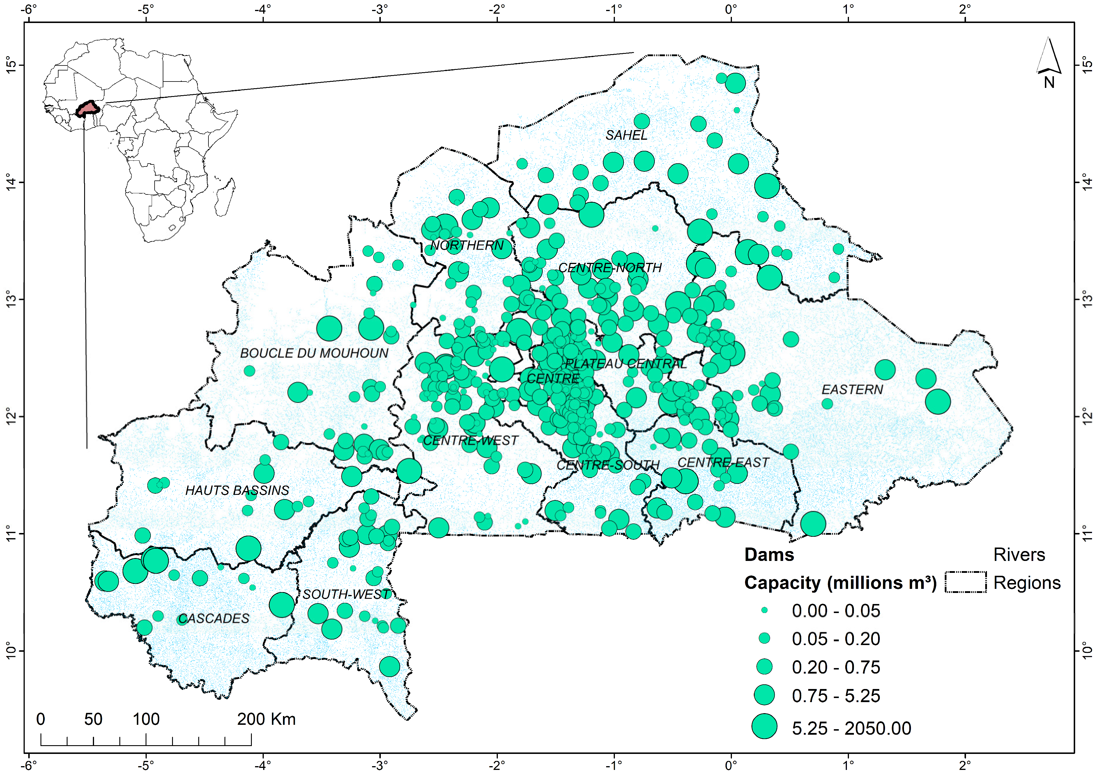
2.1. Study Area Description

Burkina Faso, a Sahelian and inland country (274,200 km2), encompasses a hot semi-arid climate within its geographical boundaries. The country is located between latitudes 9° and 15° North and longitudes 2°20′ East and 50°3′ West. The average annual precipitation in Burkina Faso is approximately 750 mm, with a rainy season extending from June to October. The average annual temperatures fluctuate between 23 °C and 32 °C, while the average annual evapotranspiration reaches 2000 to 2500 mm. The aridity index, which assesses the dryness of the local climate, varies between 0.05 and 0.2, highlighting the significant pressure on water resources due to high evaporative demand [21,46].
Agriculture is the primary economic activity in Burkina Faso, with over 90% of the rural population engaged in subsistence farming [9]. This form of agriculture faces considerable challenges, notably the scarcity of water, among other issues. Since the 1980s, the government has undertaken initiatives to secure water for the population’s needs and also mitigate the risks associated with flooding resulting from extreme rainfall events, which are increasing in both magnitude and occurrence. Additionally, there has been a focus on the development of earth dams, leading to the impoundment of numerous structures [8]. Yet, the inventory and the monitoring of these earth dams have been poorly carried out and have become increasingly difficult to operate in remote locations, especially with the recent context of the security crisis prevailing in Burkina Faso since 2015. Estimations by Cecchi and Venot suggest that there are nearly 1700 small earth dams across Burkina Faso. In contrast, official sources, such as the “Dam Maintenance and Safety Framework Report” of 2020, report a total of 1794 existing water reservoirs, which includes 1001 dams across the country [6,8,47]. From 2012 to 2020, a total of 34 dams were constructed, while an additional 44 were rehabilitated, thereby increasing their total number to 1035 by 2020. This resulted in a cumulative storage capacity of 6.14 billion m3 across the country’s territory [47]. Additionally, the discrepancy in the total number of dams in the country is related to the fact that several reservoirs are not officially classified as dams, however widely used by local populations for water provision. The national database maintained by DGRE lists 713 dams, the location of which is given in Figure 1. Yet, this database is acknowledged as more recent, reliable, and comprehensive, as it encompasses all structures within the operational management framework of water resources by DGRE. In terms of classification, DGRE, like many national water management authorities, classifies water reservoirs based on their size, purpose, and volume. These classifications could range from small, local reservoirs used for irrigation to large, multi-purpose reservoirs that serve for drinking water supply, flood control, and hydroelectric power generation. In Burkina Faso, the official classification is based on the approval required for their implementation, which is defined by the National Committee of Dams of Burkina Faso (“Comité National des Grands Barrages”, CNBB). The W-BAH1, W-BAH2, and W-BAH3 approvals categorize dams according to their embankment height (H) and volume (V) of retention, as shown in Table 1.
However, it is important to emphasize that these definitions do not claim to be universal and that they are not regulatory at the international level.
Figure 2 shows the characteristics of the 713 dams listed in the DGRE database in terms of repartition by capacity (volume) and by year of construction, which reveals an aging dam network comprising 900 dams with an average age of around 40 years.

2.2. Sampling of Dams

Figure 1 shows the location of the 713 dams officially recorded in the DGRE database over the country’s territory. In this study, since the focus is small earth dams, we focused on the criteria defined by the W-BAH1 and W-BAH2 approvals, which covers dams of volume below 5,000,000 m3 and whose embankment body is made up of homogeneous earth material, also referred to as a “dike”.
Given the context of insecurity in recent years (since 2015), detailed technical visits (DTVs), normally carried out each year by DGRE agents, have been irregular and limited to checkpoints within a 100 km radius of the capital city, Ouagadougou. In total, within the DGRE database, 31 dams are recorded as large, while 682 are considered to be medium and small dams (W-BAH1 and W-BAH-2 approvals, respectively). In this group, 152 are located close to the capital city, in the Centre, the Centre-West, and the Northern Regions. We initially sampled this total to identify the minimum number of dams to be considered for further physical investigation and DTV in this study, using the sampling without replacement formula, including a correction for finite population, as shown in Equation (1) [48,49]:
n 0 = N Z α / 2 2 p ( 1 p ) e 2 N 1 + Z α / 2 2 p 1 p
where n0 is the sample size for a finite population, N = 152 is the population size, Zα/2 =1.64 is the critical value of the standard normal distribution to the significance level α = 10% (i.e., a confidence level of 90%), p = 50% is the expected sampling probability and e = 15% is the allowable error margin. The sample size n0, therefore, obtained is 25 (i.e., a sampling proportion of n0/N = 16%). However, in definitive, only 24 small dams (the location of which is given in Figure 3) were retained. For representativeness concerns, these dams were selected so that they cover varying age groups and geometric characteristics, as summarized in Table 2. Three (3) age groups are therefore covered: old dams built before the 1980s, dams built between 1980 and 2000, and those of a younger age built after 2000. The retention capacities (Cap), embankment lengths (L), and crest ridge widths (W) of the dikes of these dams are also provided in Table 2.

2.3. Physical Investigations through Detailed Technical Visits (DTVs)

According to regulations, detailed technical visits (DTVs) are continuous, comprehensive walking inspections of the dam embankment dike and its associated structures aimed at identifying and documenting any disorders or suspected disorders affecting them [50,51]. These physical investigations facilitate the analysis of the condition of the dikes and enable the monitoring of identified anomalies over time. The methodology employed for the DTV on the study sites involved the identification and description of the typologies of external and internal degradation observed during the linear traversal of several hundred meters along the dam dike. Furthermore, an explanation of the probable causes of this deterioration and the consequent impacts on the holding capacity of these structures is provided. Illustrations of the degradations observed along the field surveys were taken using a mobile geotagging location Android application (GPS Map Camera, https://play.google.com/store/apps/details?id=com.gpsmapcamera.geotagginglocationonphoto accessed on 2 September 2021).
External deterioration can be defined as the superficial part of the structure. This type of deterioration is readily detectable and may portend potential failures of the structure in the short term if not addressed. In contrast, internal deterioration pertains to the internal aspects of the dike and its associated structures, potentially leading to a loss of retention capacity. Such deterioration can be detected using certain hydraulic phenomena, such as backward erosion and the presence of water within the dike body or downstream of the dike [14,20,31].

2.4. Statistical Analyses

Based on the data collected on the selected 24 dams investigated in this study, some statistical investigations are carried out to identify potential associations between the different forms of degradations observed on the sample of dams. In this case, we used the φ coefficient (or mean square contingency coefficient), which is a measure of association between two binary variables, which takes the value of 1 when a degradation is observed (and 0 otherwise). The φ coefficient ranges between −1 and 1 for perfectly negative and perfectly positive association, while 0 stands for no association. It is suggested that 0.3 φ 0.3 indicate little or no association, 0.7 φ 0.3 and 0.3 φ 0.7 indicate weak negative and weak positive association, respectively, and 1.0 φ 0.7 and 0.7 φ 1.0 indicate strong negative and strong positive association [52]. The coefficient is calculated in this study using the R package psych [53].
Additionally, to investigate whether some specific degradations could be explained by specific characteristics of the dam embankment, we fit a binary logistic model for each type of degradation [54], where the response value is the occurrence of an event π , which takes the value of 1 when the degradation is observed (and 0 otherwise). The explanatory variables used are the damage (Y), i.e., number of years since the dam construction, the dike length (L), the crest width (W), and the position of the weir (Weir), either being central or lateral along the dike embankment length. The logistic model is fitted using the glm command from the R base stats package [55] and is defined as in Equation (2):
log π 1 π = β 0 + β 1 L + β 2 W + β 3 Y + β 4 W e i r
where log π / ( 1 π ) is the log of the odds of the event π (i.e., the occurrence of a given degradation), expressed as a binary outcome, β 0 is the model intercept, β 1 , β 2 , β 3 and β 4 are the coefficients of the predictors L, W, Y, and Weir. The significance of these coefficients is assessed using the Wald test, which is the test of significance for individual regression coefficients in logistic regression (at α = 10% significance level, given the size of our sample).

3. Results and Discussion

3.1. Observations from DTVs

Figure 4, Figure 5, Figure 6, Figure 7, Figure 8, Figure 9, Figure 10, Figure 11, Figure 12 and Figure 13 illustrate the degradation observed on the various sites visited. A pronounced aspect of surface erosion has been noted, with a significant presence of gullies on the irregular slopes (Figure 4a,b), accounting for slightly more than 87% of the structures visited. These gullies manifest as channels that deepen in the direction of the slope. Observations suggest that they are due to the concentration of runoff water, which can transform the dyke downstream facing into a “ploughed field” [18,25,56], thereby compromising its safety [57]. According to [25], this phenomenon is relatively common on unprotected slopes (often opted as a cost-saving measure) or those irregularly covered by vegetation, rendering the structure susceptible to erosion risk due to runoff.
Figure 4. (a) Gully on a downstream slope, Petit Tansobentenga dam (Centre Region). (b) Gully on a downstream slope, Godin-Oudalogtinga dam (Centre-West Region).
Resources 13 00071 g004
Additionally, disorders characterized by degradation of the upstream banks, including those with riprap protection, were observed (Figure 5a,b) along the entire length of the dike on nearly 92% of the selected structures. These disorders are likely attributable to the effects of wave action generally caused by wind. The energy of the waves breaking on the riprap allows water to penetrate, enabling reflux movements to damage the revetment by displacing or carrying away the riprap blocks.
Figure 5. (a) Disorders on upstream riprap, Koala dam (Centre Region). (b) Disorder on upstream riprap, Siga dam (Centre Region).
Resources 13 00071 g005
Subsidence and trampling, typical of anthropogenic erosion, were also observed, as indicated in Figure 6a,b. The evolving nature of the construction material, combined with the effects of routine vehicle overloading (which is common practice in the context), accelerates the degradation of the platforms. The trampling phenomenon is particularly significant when the constituent material of the dike has low cohesion [58]. The presence of a cohesive material on these dikes slows this type of erosion but requires regular monitoring, which is virtually non-existent in Burkina Faso.
Figure 6. (a) Anthropogenic erosion of the platform, Ramogwende dam (Centre Region). (b) Anthropogenic erosion of the platform (due to vehicle passage), Ridrin dam (Centre Region).
Resources 13 00071 g006
Burrows manifesting as gaping holes in the embankment caused by the presence of burrowing animals such as rodents or crocodiles (Figure 7a,b) were also noted on a few structures, accounting for only 8% of the dikes in our sample. The trampling phenomenon is particularly significant when the constituent material of the dike has low cohesion [58]. The presence of a cohesive material on these dikes slows this type of erosion but requires regular monitoring.
Figure 7. (a) Presence of burrows on the dam due to rodents, Siga dam (Centre Region). (b) Presence of burrows due to digging crocodiles, Veh dam (Northern Region).
Resources 13 00071 g007
Large-scale vegetation growth was also observed on the sites, as illustrated in Figure 8a,b. Given the extent of this phenomenon, it is important to note the critical lack of maintenance these structures face. According to [59,60], who addressed the issue of vegetation growth on French river dikes and small earth dams via the development and decomposition of root systems, the presence of woody plant species poses physical and integrity safety concerns [61]. Trees and shrubs obstruct visual surveillance of the structures and also promote the presence of burrowing animals that dig burrows in the embankments, as previously shown in Figure 7a. [62] emphasizes that the development and decay of root systems are factors that weaken dikes in the short and medium term. Our DTVs revealed that 100% of our dikes are affected by vegetation growth. To highlight a potential cause-and-effect relationship between vegetation growth and erosion, it is suggested that the development of woody root systems within our dikes generates risks of degradation and erosion related to the action of living roots and the phenomenon of wood decomposition [59].
Figure 8. (a) Vegetation on dam and spillway, Koakin dam (Centre Region). (b) Vegetation on upstream and downstream slopes, Kalzi dam (Centre Region).
Resources 13 00071 g008
Additionally, it should be noted that trees uprooted by wind can cause visible damage, while decomposed roots leave unperceivable galleries within the embankments through which water can find passage [59]. Of the dikes that are part of our field study, 50% also show water leakage from upstream to downstream at the base of the slope, as indicated in Figure 9a,b.
Figure 9. (a) Presence of slight leak in the upstream-downstream direction, Doulou dam (Centre-West Region). (b) Presence of slight leak in the upstream-downstream direction, Ramogwende dam (Centre region).
Resources 13 00071 g009
Among the other disorders observed, transverse cracks in the embankment dike, as illustrated in Figure 10a,b, were noted, particularly in zones of rupture or near-rupture. Their potential causes include differential settlement leading to fractures in the structures or internal erosion revealing water passage within the embankment body. These transverse cracks, however, could also be attributed to a lack of comprehensive technical studies before execution, which would ensure better consideration of the force of floodwaters the structure must withstand [22,25].
Figure 10. (a) Transverse cracking, Salouf Boulssi dam (Centre Region). (b) Transverse cracking, Veh dam (Northern Region).
Resources 13 00071 g010
The destruction of the stilling basin and the evacuation channel, as shown in Figure 11a,b, representing the Tansablogo II dam (Centre Region), perfectly illustrates the poor dimensioning of the spillway and its components. The consideration of hydraulic jumps emerging in the dissipation basin was largely underestimated or minimized for most of these structures, as suggested in [63]. Nearly 75% of our structures exhibited such type of degradation.
Figure 11. (a) Destroyed dissipation basin and eroded evacuation channel, Tansablogo II dam. (b) Destroyed gabion cage and dissipation basin, eroded evacuation channel, Koakin dam (Centre Region).
Resources 13 00071 g011
The stilling basins in place are primarily made up of concrete, with a notable lack of maintenance observed in many of these structures, including ancillary structures such as water intakes (Figure 12a,b).
Figure 12. (a) Aging intake structure, Petit Tansobentenga dam (Centre Region). (b) Aging intake structure, Taama dam (Centre Region).
Resources 13 00071 g012
It is also worth noting that the presence of internal erosion on the crest is the source of infiltration into the embankments [30,64,65,66,67,68,69,70], as shown in Figure 13a,b.
Figure 13. (a) Orifice on crest causing internal erosion, Doulou dam (Centre-West Region). (b) Orifice on crest spillway causing internal erosion, Koakin dam (Centre Region).
Resources 13 00071 g013

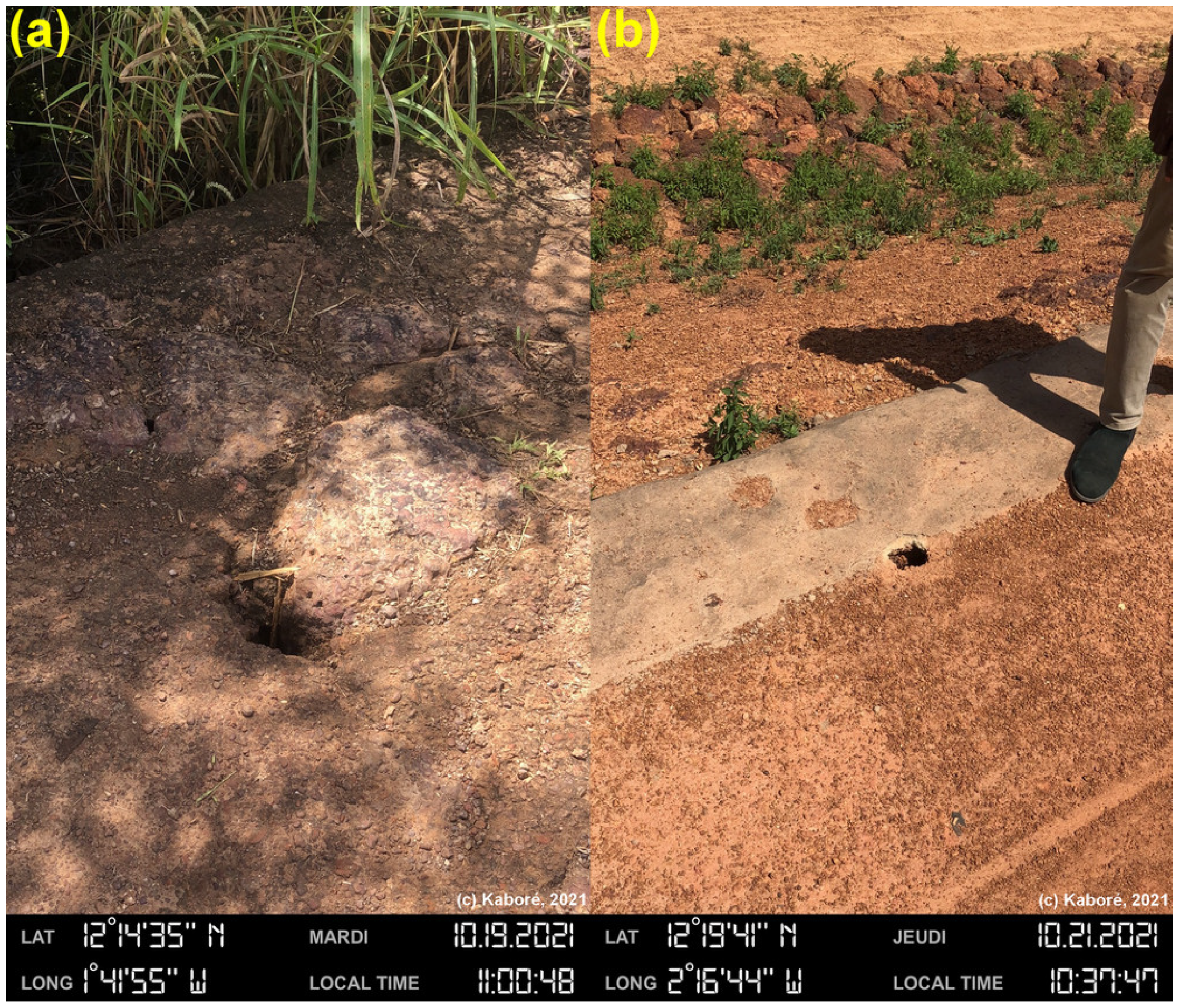
3.2. Types of Degradation

The DTVs have enabled us to categorize the dams in our sample into two categories of embankment dams, given the use of these earth dams as either crossing structures or not, considering the passage of vehicles. Therefore, in the sample, nine embankments are typically road embankments, while 15 are not. 100% of the road embankments in the sampling are still functioning normally despite some observed disorders. Conversely, only 47% of the embankments intended solely for water retention (non-road) are currently operational. These figures can be explained by the need for maintaining a connection between villages, which is an incentive for the inhabitants to pay more attention to the safety of the road embankments, therefore providing them with some maintenance activities that, unfortunately, are not supervised [8,10,41]. Some further evidence of this reason was observed in the presence of traces of plugging on specific sites and other types of manual repair likely initiated by the inhabitants.
Throughout our VTAs, we noticed disorders of several types whose frequencies of occurrence are represented in Figure 14.
It appears that 100% of the visited dams show signs of riparian vegetation growing on the embankment fill, mainly due to poor maintenance. Signs of erosion of the embankment are observed on 87% of the dams, along with cases of degradation observed on the embankment platform (87%), scouring of wave erosion (87%), and malfunction of the intake structure (87%). These disorders are followed by malfunction of the spillway and discharge channel downstream (75%), leakage through the dam body (50%), transverse cracks (37%), disorders of the riprap paving (33%), and finally, burrows in the embankment fill (8%).
Observations of disorders were made on 33% of the structures at the riprap level, primarily on their upstream side, where the main function is to protect the embankment slopes against regressive erosion caused by wave action, also known as scouring (or wave erosion of the embankment). The destruction of the riprap is also exacerbated by the root systems of trees, which disrupt the macroscopic structure of the riprap and create areas of strong adhesion that are favorable to gusts of wind [59,60,62]. The 13% of structures not affected by this type of disorder are recent structures less than 20 years old. This type of erosion only affects dams of a certain age. Vegetation is a cause of aging in its own right, as neglected dams age prematurely [59].
50% of the 24 embankments inspected showed leaks downstream, which could potentially be explained by a problem of internal erosion, namely suffusion, characterized by the migration of fine particles, an increase in porosity, and an impact on the mechanical behavior of the structure [14,20,37]. According to [71], this form of erosion, caused by the canalization of soil grains through concentrated leaks, is deemed responsible for half of the dam failures worldwide. The presence of water at the downstream toe of the embankment, far from the spillway, is therefore indicative of internal problems such as erosion. Erosion can have multiple causes and indicates the presence of water movement inside or under the embankment.
Almost all (87%) of the diagnosed structures showed signs of slope erosion, except the Kalzi and Saria II dams in the Centre Region, which have all undergone recent rehabilitation. Additionally, structures that have experienced a transverse rupture are characterized by a lack of foundation trench, making them vulnerable to water pressure [14,72]. The hypothesis of a design defect is mostly consistent for many of them, given the observed reliefs during the DTVs.
Out of the 24 structures visited, 75% showed degradation of their stilling basins, which are out of service. These basins were built with gabion cages placed at the toe of the spillway to protect these structures against the effects of hydraulic jumps during flood periods. In line with the state of these stilling basins, the evacuation channels presented by these structures show characteristic traits of regressive erosion. Only 25% of the structures have a stilling basin and an evacuation channel in proper working order. They all have one common characteristic: they are all made of concrete. This finding highlights the low efficiency or under-sizing of the stilling basins of many structures that chose gabions to channel the effects of hydraulic jumps created in the flood evacuators [63,73].
Finally, other disorders such as burrows of burrowing animals (rats, crocodiles), observed in 8% of the visited dams, malfunction of intake structures (87%), encased piping installed by farmers in an artisanal way for the exploitation of the reservoir, and trampling due to the passage of traffic vehicles also put certain structures in danger [69,70].

3.3. Statistical Outlook of Degradation Types

Table 3 shows the evaluation of the association between the different forms of degradation observed on the 24 investigated small earth dams in this study.
The results show that there is a strong positive association (almost perfect, φ = 1.000) between erosion of the embankment, wave erosion, degradation of the embankment, and malfunction of the intake structure. Additionally, the malfunction of the spillway is strongly associated with the erosion of the embankment, wave erosion, degradation of the embankment, and malfunction of the intake ( φ = 0.655). Finally, a weak association is revealed between the transverse cracks and water leakages through the embankment ( φ = 0.430) and also between the water leakages and the presence of animal burrows ( φ = 0.302).
Table 4 lists the dam characteristics emerging as significant when fitting a binary logistic model to explain a given type of degradation.
The analysis shows that transverse cracks are significantly affected by the dike length (p-value = 0.094), that malfunction of the spillway is significantly affected by the weir position along the dike length (p-value = 0.091), and those water leakages are significantly affected by the dam embankment width (p-value = 0.085). For the other degradation types, no characteristic was found to be significant at the 10% level. Similar findings have been reported earlier [15,25,35,36,63,66].

3.4. Potential Causes of Degradations

Table 5 lists the types of degradations observed in this study, along with their potential causes.
From a general perspective, the observed degradations show impacts that call into question the functioning of these structures. Indeed, dams that have undergone partial to total ruptures no longer serve their retention function. 33% of the visited structures present such type of failure. In light of the investments made by decision-makers to achieve food self-sufficiency in the coming years, such losses constitute a missed opportunity for populations in terms of water reservoirs. These waterbodies allowed for simple agriculture as well as large-scale off-season agriculture in several localities in Burkina Faso [8,9,41,42]. Fishing and livestock activities are also affected, and they suffer the same damages as agriculture by losing these reservoirs.
Regarding structures that are still functional, certain degradations undermine their usefulness. This is the case, for example, of the dams of Koala, Kalzi, Ridrin, Tansablogo II, and Ramogwende in the Central Region, and Saria II and Doulou in the Centre-West Region, or nearly 46% of the reservoirs presenting an upstream-downstream leakage flow. Combined with high evapotranspiration, the water recedes permanently as early as February, greatly reducing the contribution of these structures.
Burrows, although observed to a minor extent (8%), open pathways for water infiltration. This contributes to making the platforms sometimes moderately usable during the rainy season by causing the loosening of the embankment during periods of high flood and the infiltration of rainwater.
In terms of future perspectives, it should be noted that in-depth investigations, consisting of laboratory mechanical tests on samples collected on embankments of the investigated dams in this study, are needed. These analyses will shed light on the physical and mechanical disturbances caused by the deterioration factors highlighted in this study and provide insights into the formulation of practical recommendations for the small earth dam construction process.

4. Conclusions

This analysis was conducted on a sample of 24 earth dams in Burkina Faso constructed from laterite. The study complements the regular monitoring that these structures should undergo throughout their life cycle to ensure periodic or occasional maintenance.
The study aims to provide an inventory of the typical various types of degradation observable on such structures, assess their frequency of occurrence, and identify their potential causes and consequences. Through physical investigations carried out during detailed technical visits, the study revealed a diversity of disorders, including slope erosion, surface and internal contact erosion within the embankment body, vegetation problems, trampling, spillway malfunction, and even total failure in some structures. The study showed that a significant proportion of these structures are in poor condition, with 33% of the sampled dams having experienced total failure. Many associated structures, such as intakes, stilling basins, and their evacuation channels, are out of service in 75% of the structures studied.
This situation of structures in a state of dysfunction generates negative consequences for water resource mobilization for agriculture and has considerable impacts on the daily lives of populations highly affected by rainfall variability and strongly experiencing the effects of climate change. This study provides orders of magnitude of the state and frequency of occurrence of major disorders affecting earth dams in the Sahelian zone and should help prioritize actions to restore the long-term functionality of these structures.
The statistical analysis and modeling in this study highlighted some associations between geometrical aspects of small earth dams, such as length, width, or weir position, with typical degradations such as transverse cracks, water leakage, and weir malfunction. However, some of the links also show the connection between the appearance of certain types of degradation that could manifest themselves in a chain of cause and effect and should be further investigated. Future prospects of carrying out a more in-depth analysis on a larger number of earth dams are needed in order to better characterize the folklore of small earth dams in Burkina.

Author Contributions

Conceptualization, M.P.J.K., A.L., R.Y., A.C.B. and A.N.; methodology, M.P.J.K., A.L., R.Y., A.C.B. and A.N.; software, M.P.J.K. and R.Y.; validation, M.P.J.K., A.L., R.Y., A.N. and A.P.; formal analysis, M.P.J.K., A.L., R.Y. and A.N.; investigation, M.P.J.K., A.L., R.Y., A.C.B. and A.N.; resources, A.L., A.N. and A.P.; data curation, M.P.J.K. and R.Y.; writing—original draft preparation, M.P.J.K., A.L. and R.Y.; writing—review and editing, M.P.J.K., A.L., R.Y., A.N., A.C.B. and A.P.; visualization, M.P.J.K. and R.Y.; supervision, A.L., R.Y. and A.N.; project administration, A.L. and A.N.; funding acquisition, A.L. All authors have read and agreed to the published version of the manuscript.

Funding

The authors are grateful to the World Bank Group and the Government of Burkina Faso for their financial support of this research, completed as part of a PhD thesis, through the Africa Higher Education Centers of Excellence for Development Impact Project (IDA 6388-BF/D443-BF).

Data Availability Statement

The data used in this study can be obtained upon reasonable request by the corresponding author.

Conflicts of Interest

The authors declare that this study received funding from the World Bank Group. The funder was not involved in the study design, collection, analysis, interpretation of data, the writing of this article, or the decision to submit it for publication.

References

  1. Schnitter, N.J. A History of Dams: The Useful Pyramids; A.A. Balkema: Rotterdam, The Netherlands, 1994; ISBN 978-90-5410-149-9. [Google Scholar]
  2. Andreini, M.; Schuetz, T.; Senzanje, A.; Rodríguez, L.; Andah, W.; Cecchi, P.; Boelee, E.; van de Giesen, N.; Kemp-Benedict, E.; Liebe, J.R. Small Multi-Purpose Reservoir Ensemble Planning; CGIAR Challenge Program on Water and Food: Colombo, Sri Lanka, 2009; pp. 1–14. Available online: https://www.researchgate.net/publication/241385289_Small_Multi-purpose_Reservoir_Ensemble_Planning_Innovative_Methods (accessed on 6 March 2024).
  3. Fowe, T.; Karambiri, H.; Paturel, J.-E.; Poussin, J.-C.; Cecchi, P. Water Balance of Small Reservoirs in the Volta Basin: A Case Study of Boura Reservoir in Burkina Faso. Agric. Water Manag. 2015, 152, 99–109. [Google Scholar] [CrossRef]
  4. Poussin, J.-C.; Renaudin, L.; Adogoba, D.; Sanon, A.; Tazen, F.; Dogbe, W.; Fusillier, J.-L.; Barbier, B.; Cecchi, P. Performance of Small Reservoir Irrigated Schemes in the Upper Volta Basin: Case Studies in Burkina Faso and Ghana. Water Resour. Rural. Dev. 2015, 6, 50–65. [Google Scholar] [CrossRef]
  5. Mounirou, L.A.; Sawadogo, B.; Yanogo, H.; Yonaba, R.; Zorom, M.; Faye, M.D.; Kafando, M.B.; Biaou, A.C.; Koïta, M.; Karambiri, H. Estimation of the Actual Specific Consumption in Drinking Water Supply Systems in Burkina Faso (West Africa): Potential Implications for Infrastructure Sizing. Water 2023, 15, 3423. [Google Scholar] [CrossRef]
  6. Cecchi, P.; Meunier-Nikiema, A.; Moiroux, N.; Sanou, B. Towards an Atlas of Lakes and Reservoirs in Burkina Faso. In Small Reservoirs Tool Kit; CGIAR: Colombo, Sri Lanka, 2008; pp. 1–20. [Google Scholar]
  7. Kafando, M.B.; Koïta, M.; Le Coz, M.; Yonaba, O.R.; Fowe, T.; Zouré, C.O.; Faye, M.D.; Leye, B. Use of Multidisciplinary Approaches for Groundwater Recharge Mechanism Characterization in Basement Aquifers: Case of Sanon Experimental Catchment in Burkina Faso. Water 2021, 13, 3216. [Google Scholar] [CrossRef]
  8. Cecchi, P.; Forkuor, G.; Cofie, O.; Lalanne, F.; Poussin, J.-C.; Jamin, J.-Y. Small Reservoirs, Landscape Changes and Water Quality in Sub-Saharan West Africa. Water 2020, 12, 1967. [Google Scholar] [CrossRef]
  9. Lèye, B.; Zouré, C.O.; Yonaba, R.; Karambiri, H. Water Resources in the Sahel and Adaptation of Agriculture to Climate Change: Burkina Faso. In Climate Change and Water Resources in Africa; Diop, S., Scheren, P., Niang, A., Eds.; Springer International Publishing: Cham, Switzerland, 2021; pp. 309–331. ISBN 978-3-030-61224-5. [Google Scholar]
  10. Venot, J.-P.; Cecchi, P. Use-Value or Performance: Towards a Better Understanding of Small Reservoirs in Sub-Saharan Africa. Cah. Agric. 2011, 20, 112–117. [Google Scholar] [CrossRef]
  11. Yonaba, R.; Biaou, A.C.; Koïta, M.; Tazen, F.; Mounirou, L.A.; Zouré, C.O.; Queloz, P.; Karambiri, H.; Yacouba, H. A Dynamic Land Use/Land Cover Input Helps in Picturing the Sahelian Paradox: Assessing Variability and Attribution of Changes in Surface Runoff in a Sahelian Watershed. Sci. Total Environ. 2021, 757, 143792. [Google Scholar] [CrossRef] [PubMed]
  12. Fowé, T.; Yonaba, R.; Mounirou, L.A.; Ouédraogo, E.; Ibrahim, B.; Niang, D.; Karambiri, H.; Yacouba, H. From Meteorological to Hydrological Drought: A Case Study Using Standardized Indices in the Nakanbe River Basin, Burkina Faso. Nat. Hazards 2023, 119, 1941–1965. [Google Scholar] [CrossRef]
  13. Giorgis, I.; Bonetto, S.; Giustetto, R.; Lawane, A.; Pantet, A.; Rossetti, P.; Thomassin, J.-H.; Vinai, R. The Lateritic Profile of Balkouin, Burkina Faso: Geochemistry, Mineralogy and Genesis. J. Afr. Earth Sci. 2014, 90, 31–48. [Google Scholar] [CrossRef]
  14. Flores-Berrones, R.; Ramírez-Reynaga, M.; Macari, E.J. Internal Erosion and Rehabilitation of an Earth-Rock Dam. J. Geotech. Geoenviron. Eng. 2011, 137, 150–160. [Google Scholar] [CrossRef]
  15. Adamo, N.; Al-Ansari, N.; Sissakian, V.; Laue, J.; Knutsson, S. Dam Safety: Technical Problems of Aging Embankment Dams. J. Earth Sci. Geotech. Eng. 2020, 10, 281–322. [Google Scholar]
  16. Chraibi, A.F.; Nombré, A. Comoe Dam Lateritic Foundation Treatment. In Grouting 2017; American Society of Civil Engineers: Honolulu, HI, USA, 2017; pp. 21–32. [Google Scholar]
  17. Persons, B.S. Laterite: Genesis, Location, Use; Monographs in Geoscience; Springer: New York, NY, USA, 2012; ISBN 978-1-4684-7215-8. [Google Scholar]
  18. Andreini, M.; Gardoni, P.; Pagliara, S.; Sassu, M. Probabilistic Models for the Erosion Rate in Embankments and Reliability Analysis of Earth Dams. Reliab. Eng. Syst. Saf. 2019, 181, 142–155. [Google Scholar] [CrossRef]
  19. Mbengue, M.T.M.; Lawane Gana, A.; Messan, A.; Pantet, A. Geotechnical and Mechanical Characterization of Lateritic Soil Improved with Crushed Granite. Civ. Eng. J. 2022, 8, 843–862. [Google Scholar] [CrossRef]
  20. Jalil, A.; Benamar, A.; Ebn Touhami, M. Assessment of a Dam Vulnerability to Internal Erosion Due to Climate Change in Morocco. Innov. Infrastruct. Solut. 2020, 5, 48. [Google Scholar] [CrossRef]
  21. Yonaba, R.; Tazen, F.; Cissé, M.; Mounirou, L.A.; Belemtougri, A.; Ouedraogo, V.A.; Koïta, M.; Niang, D.; Karambiri, H.; Yacouba, H. Trends, Sensitivity and Estimation of Daily Reference Evapotranspiration ET0 Using Limited Climate Data: Regional Focus on Burkina Faso in the West African Sahel. Theor. Appl. Climatol. 2023, 153, 947–974. [Google Scholar] [CrossRef]
  22. Leonards, G.A.; Narain, J. Flexibility of Clay and Cracking of Earth Dams. J. Soil Mech. Found. Div. 1963, 89, 47–98. [Google Scholar] [CrossRef]
  23. Sivakumar Babu, G.L.; Srivastava, A. Reliability Analysis of Earth Dams. J. Geotech. Geoenviron. Eng. 2010, 136, 995–998. [Google Scholar] [CrossRef]
  24. Foster, M.; Fell, R.; Spannagle, M. The Statistics of Embankment Dam Failures and Accidents. Can. Geotech. J. 2000, 37, 1000–1024. [Google Scholar] [CrossRef]
  25. Lautrin, D. Vieillissement et Réhabilitation des Petits Barrages en Terre; Cemagref Editions: Paris, France, 2003; Available online: https://www.eyrolles.com/BTP/Livre/vieillissement-et-rehabilitation-des-petits-barrages-en-terre-9782853625975/ (accessed on 6 March 2024).
  26. Costa, L.M.; Alonso, E.E. Predicting the Behavior of an Earth and Rockfill Dam under Construction. J. Geotech. Geoenviron. Eng. 2009, 135, 851–862. [Google Scholar] [CrossRef]
  27. Arulanandan, K.; Perry, E.B. Erosion in Relation to Filter Design Criteria in Earth Dams. J. Geotech. Energy 1983, 109, 682–698. [Google Scholar] [CrossRef]
  28. Planès, T.; Mooney, M.A.; Rittgers, J.B.R.; Parekh, M.L.; Behm, M.; Snieder, R. Time-Lapse Monitoring of Internal Erosion in Earthen Dams and Levees Using Ambient Seismic Noise. Géotechnique 2016, 66, 301–312. [Google Scholar] [CrossRef]
  29. Biswas, N.; Chakraborty, S.; Mosadegh, L.; Puppala, A.J.; Corcoran, M. Influence of Anisotropic Permeability on Slope Stability Analysis of an Earthen Dam during Rapid Drawdown. In Proceedings of the Geo-Congress 2020, Minneapolis, MN, USA, 21 February 2020; American Society of Civil Engineers: Reston, VA, USA, 2020; pp. 29–39. [Google Scholar]
  30. Kacimov, A.R.; Yakimov, N.D.; Šimůnek, J. Phreatic Seepage Flow through an Earth Dam with an Impeding Strip. Comput. Geosci. 2020, 24, 17–35. [Google Scholar] [CrossRef]
  31. Fell, R.; Wan, C.F.; Cyganiewicz, J.; Foster, M. Time for Development of Internal Erosion and Piping in Embankment Dams. J. Geotech. Geoenviron. Eng. 2003, 129, 307–314. [Google Scholar] [CrossRef]
  32. Benz, T.; Nordal, S. Numerical Methods in Geotechnical Engineering: (NUMGE 2010); A Balkema Book; CRC Press: Boca Raton, FL, USA, 2010; ISBN 978-0-203-84236-2. [Google Scholar]
  33. Tourment, R.; Beullac, B.; Deniaud, Y.; Simm, J.; Wallis, M.; Sharp, M.; Pohl, R.; Van Hemert, H. De l’EDD Des Digues En France Aux Travaux de l’ILH Sur Les Mécanismes Élémentaires et Les Scénarios de Défaillance. In Proceedings of the Digues Maritimes et Fluviales de Protection Contre les Submersions-2ème Colloque National-Digues 2013, Aix-en-Provence, France, 12–14 June 2013; pp. 289–297. [Google Scholar]
  34. Bambara, G.; Curt, C.; Mériaux, P.; Vennetier, M.; Vanloot, P. Évaluation de La Vulnérabilité des Digues Fluviales Soumises Au Développement d’une Végétation Arborescente. In Proceedings of the 32èmes Rencontres Universitaires de Génie Civil, Orléans, France, 4–6 June 2014; pp. 379–388. [Google Scholar]
  35. Boussafir, Y.; Saussaye, L.; Dissler, E.; Durand, E. Des Anomalies Géotechniques à l’origine de Propositions d’indicateurs de Durabilité Pour Les Digues Fluviales. In Proceedings of the 9èmes JNGG: Journées Nationales de Géotechnique et de Géologie de L’ingénieur 2018, Champs sur Marne, France, 13–15 June 2018; p. 33. [Google Scholar]
  36. Boussafir, Y.; Tourment, R.; Veylon, G.; Durand, E.; Saussaye, L.; Reiffsteck, P. Évaluer L’ Impact du Vieillissement des Digues Sur Les Mécanismes et Scénarios de Rupture. In Proceedings of the Digues Maritimes et Fluviales de Protection Contre les Inondations—3e Colloque—Digues 2019, Aix-en-Provence, France, 20–21 March 2019; p. 9. [Google Scholar]
  37. Saliba, F.; Nassar, R.B.; Khoury, N.; Maalouf, Y. Internal Erosion and Piping Evolution in Earth Dams Using an Iterative Approach. In Proceedings of the Geo-Congress 2019, Philadelphia, PA, USA, 21 March 2019; American Society of Civil Engineers: Reston, VA, USA, 2019; pp. 67–75. [Google Scholar]
  38. Venot, J.-P.; Torou, B.M.; Daré, W. Territorialisation ou spatialisation: Les agences et comités locaux de l’eau au Burkina Faso. L’Espace Géogr. 2014, 43, 148–163. [Google Scholar] [CrossRef]
  39. Zouré, C.; Queloz, P.; Koïta, M.; Niang, D.; Fowé, T.; Yonaba, R.; Consuegra, D.; Yacouba, H.; Karambiri, H. Modelling the Water Balance on Farming Practices at Plot Scale: Case Study of Tougou Watershed in Northern Burkina Faso. Catena 2019, 173, 59–70. [Google Scholar] [CrossRef]
  40. Zouré, C.O.; Kiema, A.; Yonaba, R.; Minoungou, B. Unravelling the Impacts of Climate Variability on Surface Runoff in the Mouhoun River Catchment (West Africa). Land 2023, 12, 2017. [Google Scholar] [CrossRef]
  41. Cecchi, P. Les petits barrages au Burkina Faso: Un vecteur du changement social et de mutations des réalités rurales. In Pre Forum Mondial de l’Eau; IRD: Ouagadougou, Burkina Faso, 2006; Volume 12. [Google Scholar]
  42. Boelee, E.; Yohannes, M.; Poda, J.-N.; McCartney, M.; Cecchi, P.; Kibret, S.; Hagos, F.; Laamrani, H. Options for Water Storage and Rainwater Harvesting to Improve Health and Resilience against Climate Change in Africa. Reg. Environ. Change 2013, 13, 509–519. [Google Scholar] [CrossRef]
  43. Daré, W.; Venot, J.-P. Room for Manoeuvre: User Participation in Water Resources Management in Burkina Faso. Dev. Policy Rev. 2018, 36, 175–189. [Google Scholar] [CrossRef]
  44. Boutonnier, L.; Boussafir, Y.; Tourment, R.; Courivaud, J.-R. Effet Du Changement Climatique Sur Les Mécanismes de Retrait-Gonflement et La Stabilité des Digues et Barrages. In Proceedings of the Vingt Septieme Congrès des Grands Barrages, Marseille, France, 27 May–3 June 2022; Commission Internationale des Grands Barrages—CIGB: Paris, France, 2022; p. 21. [Google Scholar]
  45. Ghimire, S.N.; Schulenberg, J.W. Impacts of Climate Change on the Environment, Increase in Reservoir Levels, and Safety Threats to Earthen Dams: Post Failure Case Study of Two Cascading Dams in Michigan. Civ. Environ. Eng. 2022, 18, 551–564. [Google Scholar] [CrossRef]
  46. Gbohoui, Y.P.; Paturel, J.-E.; Tazen, F.; Mounirou, L.A.; Yonaba, R.; Karambiri, H.; Yacouba, H. Impacts of Climate and Environmental Changes on Water Resources: A Multi-Scale Study Based on Nakanbé Nested Watersheds in West African Sahel. J. Hydrol. Reg. Stud. 2021, 35, 100828. [Google Scholar] [CrossRef]
  47. ADF. Small Dam Rehabilitation Programme; African Development Fund: The Central Plateau, Burkina Faso, 2022; p. 49. [Google Scholar]
  48. Cochran, W.G. Sampling Techniques. In Wiley Series in Probability and Mathematical Statistics, 3rd ed.; Wiley: New York, NY, USA, 1977; ISBN 978-0-471-16240-7. [Google Scholar]
  49. Daniel, W.W.; Cross, C.L. Biostatistics: A Foundation for Analysis in the Health Sciences, 11th ed.; Wiley: Hoboken, NJ, USA, 2019; ISBN 978-1-119-49666-3. [Google Scholar]
  50. Mercklé, S.; Poulain, D. Barrage de Montbel (09). Compte Rendu de Visite Technique Approfondie Réalisée Le 12 Août 2010; Irstea: Paris, France, 2010; p. 25. [Google Scholar]
  51. EPL. Note Technique N°3—Visites Techniques Approfondies; Note Technique; Etablissment Public Loire: Orléans, France, 2013; p. 8. [Google Scholar]
  52. Cramér, H. Mathematical Methods of Statistics; Princeton Mathematical Series; Princeton University Press: Princeton, NJ, USA, 1991; ISBN 978-0-691-08004-8. [Google Scholar]
  53. Revelle, W. Psych: Procedures for Psychological, Psychometric, and Personality Research. In R: A Language and Environment for Statistical Computing; R Foundation for Statistical Computing: Vienna, Austria, 2024. [Google Scholar]
  54. Harrell, F.E. Binary Logistic Regression. In Regression Modeling Strategies; Springer Series in Statistics; Springer International Publishing: Cham, Switzerland, 2015; pp. 219–274. ISBN 978-3-319-19424-0. [Google Scholar]
  55. R Core Team. R: A Language and Environment for Statistical Computing; R Foundation for Statistical Computing: Vienna, Austria, 2024. [Google Scholar]
  56. Mounirou, L.A.; Yonaba, R.; Tazen, F.; Ayele, G.T.; Yaseen, Z.M.; Karambiri, H.; Yacouba, H. Soil Erosion across Scales: Assessing Its Sources of Variation in Sahelian Landscapes under Semi-Arid Climate. Land 2022, 11, 2302. [Google Scholar] [CrossRef]
  57. Bayoumi, A.; Meguid, M.A. Wildlife and Safety of Earthen Structures: A Review. J. Fail. Anal. Prevent. 2011, 11, 295–319. [Google Scholar] [CrossRef]
  58. Chassé, P.; Deniaud, Y.; Goutaland, D.; Kahan, J.M.; Lebreton, P.; Ledoux, P.; Rouxel, N.; Salmon, D.; Tourment, R.; Poulain, D.; et al. Référentiel Technique Digues Maritimes et Fluviales; MEDD—DGPR; HAL: Lyon, France, 2015. [Google Scholar]
  59. Zanetti, C.; Vennetier, M.; Mériaux, P.; Royet, P.; Provansal, M. Managing Woody Vegetation on Earth Dikes: Risks Assessment and Maintenance Solutions. Procedia Environ. Sci. 2011, 9, 196–200. [Google Scholar] [CrossRef]
  60. Zanetti, C.; Vennetier, M.; Mériaux, P. Développement et Décomposition des Systèmes Racinaires: Risques Induits Pour Les Digues et Solutions de Gestion. In Proceedings of the Digues Maritimes et Fluviales de Protection Contre les Submersions, Aix-en-Provence, France, 12–14 June 2013; Hermès Lavoisier: Paris, France, 2013; pp. 536–540. [Google Scholar]
  61. Bellin, N.; Van Wesemael, B.; Meerkerk, A.; Vanacker, V.; Barbera, G.G. Abandonment of Soil and Water Conservation Structures in Mediterranean Ecosystems. Catena 2009, 76, 114–121. [Google Scholar] [CrossRef]
  62. Vennetier, M.; Zanetti, C.; Meriaux, P.; Mary, B. Tree Root Architecture: New Insights from a Comprehensive Study on Dikes. Plant Soil 2015, 387, 81–101. [Google Scholar] [CrossRef]
  63. Talukdar, P.; Dey, A. Hydraulic Failures of Earthen Dams and Embankments. Innov. Infrastruct. Solut. 2019, 4, 42. [Google Scholar] [CrossRef]
  64. Onda, Y.; Itakura, N. An Experimental Study on the Burrowing Activity of River Crabs on Subsurface Water Movement and Piping Erosion. Geomorphology 1997, 20, 279–288. [Google Scholar] [CrossRef]
  65. Karastathis, V.K.; Karmis, P. Geophysical Investigations of Seepage and Settlement Effects at Mornos Dam. In Proceedings of the 74th EAGE Conference and Exhibition incorporating EUROPEC 2012, Copenhagen, Denmark, 4 June 2012; European Association of Geoscientists & Engineers: Utrecht, The Netherlands, 2012. [Google Scholar]
  66. Karastathis, V.; Karmis, P. Investigation of Seepage and Settlement Problems at the Mornos Earth Dam, Greece, by Geophysical Methods. In Proceedings of the Symposium on the Application of Geophysics to Engineering and Environmental Problems 2012, Tucson, AZ, USA, 1 January 2012; Environment and Engineering Geophysical Society: Denver, CO, USA, 2012; p. 180. [Google Scholar]
  67. Nourani, V.; Aminfar, M.H.; Alami, M.T.; Sharghi, E.; Singh, V.P. Unsteady 2-D Seepage Simulation Using Physical Analog, Case of Sattarkhan Embankment Dam. J. Hydrol. 2014, 519, 177–189. [Google Scholar] [CrossRef]
  68. Palladino, M.R.; Barbetta, S.; Camici, S.; Claps, P.; Moramarco, T. Impact of Animal Burrows on Earthen Levee Body Vulnerability to Seepage. J. Flood Risk Manag. 2020, 13, e12559. [Google Scholar] [CrossRef]
  69. Calamak, M.; Larocque, L.A.; Chaudhry, M.H. Numerical Modelling of Seepage through Earthen Dams with Animal Burrows: A Case Study. J. Hydraul. Res. 2021, 59, 488–499. [Google Scholar] [CrossRef]
  70. Ceccato, F.; Malvestio, S.; Simonini, P. Effect of Animal Burrows on the Vulnerability of Levees to Concentrated Erosion. Water 2022, 14, 2777. [Google Scholar] [CrossRef]
  71. Richards, K.S.; Reddy, K.R. Critical Appraisal of Piping Phenomena in Earth Dams. Bull. Eng. Geol. Environ. 2007, 66, 381–402. [Google Scholar] [CrossRef]
  72. Fu, X.T.; Zhang, L.P.; Wang, Y. Effect of Slope Length and Rainfall Intensity on Runoff and Erosion Conversion from Laboratory to Field. Water Resour. 2019, 46, 530–541. [Google Scholar] [CrossRef]
  73. Ponce, V.M.; Tsivoglou, A.J. Modeling Gradual Dam Breaches. J. Hydr. Div. 1981, 107, 829–838. [Google Scholar] [CrossRef]
Figure 1. Spatial distribution of dams in Burkina Faso (study area). In total, 713 dams, officially recorded in the DGRE database, are presented in this map. The Centre Region shelters the highest density of dams in the country.
Resources 13 00071 g001
Figure 2. Characteristics of dams in the DGRE database in Burkina Faso. (a) Histogram showing the number of dams by capacity (volume). The dotted vertical lines show the mean of each category. (b) Histogram showing the number of dams by construction year. It appears that the majority of dams were constructed in the 1980s and are 40 years of age.
Resources 13 00071 g002
Figure 3. Location of the 24 dams included in this study, spanning across the Centre, Centre-West, and Northern Regions in Burkina Faso. All of these dams are located within less than 100 km of the capital city, Ouagadougou.
Resources 13 00071 g003
Figure 14. Frequencies of occurrence of degradation types observed on the 24 dams inspected in this study. Orange bars refer to dam embankment superficial degradations, while the blue bar refers to dam embankment internal degradation.
Resources 13 00071 g014
Table 1. Classification of dams according to approval in vigor in Burkina Faso [10].
ApprovalSmall DamMedium DamLarge Dam
W-BAH1H ≤ 5 m and
V < 5,000,000 m3
low risks in the event of an incident
W-BAH22 m < H ≤ 5 m and
V < 5,000,000 m3
low risks in the event of an incident
5 m < H ≤ 10 m and
V < 5,000,000 m3
medium-high risk in the event of an incident
W-BAH3 H > 10 m and
V > 5,000,000 m3
high risk in the event of an incident
Table 2. Summary of the characteristics of dams included in this study.
RegionNumber of DamsYear of ConstructionUsable Capacity (m3)Dike Length (m)Crest Width (m)
Centre Region2<198075,000–4,470,000170–7102.5–7.0
111980–2000
2>2000
Centre-West Region1<1980200,000–1,275,00070–8303.0–7.0
41980–2000
1>2000
Northern Region2<198010,000–100,0002003.0–4.0
11980–2000
Table 3. Association between the types of degradations analyzed in this study.
TrCrackEroEmbWavEroDegEmBurrMalfIntakeMalfSpillWatLeakVegEm
TrCrack-0.290.290.290.080.290.250.43 *-
EroEmb--1.00 **1.00 **0.111.00 **0.65 **−0.13-
WavEro---1.00 **0.111.00 **0.65 **−0.13-
DegEm----0.111.00 **0.65 **−0.13-
Burr-----0.11−0.170.30 *-
MalfIntake------0.65 **−0.136-
MalfSpill-------0.00-
WatLeak---------
VegEm---------
TrCrack: Transverse cracks; EroEmb: Erosion of the embankment; WavEro: Scouring (or wave erosion) of the embankment; VegEm: Vegetation on the embankment; DegEm: Degradation of the embankment platform; Burr: Burrows in the embankment fill; MalfIntake: Malfunction of ancillary structures (intake structure); MalfSpill: Malfunction of ancillary structures (spillways and discharge channel); WatLeak: Water leakage through the embankment. ‘**’ refers to the strong association, while ‘*’ refers to the weak association.
Table 4. Significance (p-values) of coefficients of the explanatory variables on the type of degradation.
Type of DegradationExplanatory Variables
Length (L)Width (W)Age (Y)Weir Position (Weir)
TrCrack0.09 *0.340.940.45
EroEmb1.001.001.001.00
WavEro1.001.001.001.00
DegEm1.001.001.001.00
Burr0.610.660.550.64
MalfIntake1.001.001.001.00
MalfSpill0.100.250.550.09 *
WatLeak0.660.08 *0.780.55
VegEm1.001.001.001.00
TrCrack: Transverse cracks; EroEmb: Erosion of the embankment; WavEro: Scouring (or wave erosion) of the embankment; VegEm: Vegetation on the embankment; DegEm: Degradation of the embankment platform; Burr: Burrows in the embankment fill; MalfIntake: Malfunction of ancillary structures (intake structure); MalfSpill: Malfunction of ancillary structures (spillways and discharge channel); WatLeak: Water leakage through the embankment. ‘*’ and bold p-values designate significant coefficients at the 10% level.
Table 5. Degradation types on the investigated dams and potential causes, according to [25].
Types of DegradationDegradationsPotential Causes
External
(or superficial)
degradation
Transverse cracksPoor sizing or implementation
Erosion of the embankmentRainwater runoff in the direction of the slopes
Scouring (or wave erosion) of
the embankment
Wave action against up-facing slopes
Vegetation on the embankmentLack of maintenance
Burrows in the embankment fillPresence of burrowing animals
Malfunction of associated structures (spillways, intake structure, etc.)Lack of maintenance, poor sizing
Internal degradationDifferential settlementOverweight applied over time, reducing the void
the volume of the affected medium
Interstitial pressures during constructionPressure during construction under the effect of the embankment’s weight
Interstitial pressures in the embankment
during operation
Hydrostatic pressures combined with a directed
force in the flow direction, poorly controlled
during implementation
Sub-pressures in the dam foundationWater infiltration in the foundation during
impoundment
Internal erosion (piping, backward erosion)Concentrated water flowing through the embankment
Internal version (external suffusion)Selective entrainment of small particles inside the
interconnected pore spaces of soils by water flow paths
Internal erosion (internal suffusion)Entrainment of fine elements by infiltration flow paths
Disclaimer/Publisher’s Note: The statements, opinions and data contained in all publications are solely those of the individual author(s) and contributor(s) and not of MDPI and/or the editor(s). MDPI and/or the editor(s) disclaim responsibility for any injury to people or property resulting from any ideas, methods, instructions or products referred to in the content.

