Review

An Overview of Indoor Positioning and Mapping Technology Standards

1
State Key Laboratory of Information Engineering in Surveying, Mapping and Remote Sensing, Wuhan University, Wuhan 430079, China
2
School of Computer, Wuhan University, Wuhan 430079, China
3
School of Architecture and Urban Planning, Shenzhen University, Shenzhen 518060, China
4
School of Geography and Information Engineering, China University of Geosciences, Wuhan 430074, China
*
Author to whom correspondence should be addressed.
Standards 2022, 2(2), 157-183; https://doi.org/10.3390/standards2020012
Submission received: 24 January 2022 / Revised: 25 February 2022 / Accepted: 4 March 2022 / Published: 6 May 2022
(This article belongs to the Special Issue Feature Papers to Celebrate the Inaugural Issue of Standards)

Abstract

:
Technologies and systems for indoor positioning, mapping, and navigation (IPMN) have rapidly developed over the latest decade due to advanced radio and light communications, the internet of things, intelligent and smart devices, big data, and so forth. Thus, a group of surveys for IPMN technologies, systems, standards, and solutions can be found in literature. However, currently there is no proposed solution that can satisfy all indoor application requirements; one of the biggest challenges is lack of standardization, even though several IPMN standards have been published by different standard developing organizations (SDOs). Therefore, this paper aims to re-survey indoor positioning and mapping technologies, in particular, the existing standards related to these technologies and to present guidance in the field. As part of our work, we provide an IPMN standards system architecture consisting of concepts, terms, models, indoor positioning technologies, software and tools, applications, services and policies, and indoor mapping and modelling; and, we present IPMN standards developed for our projects in practice, such as multi-source fusion positioning data interfaces; seamless cooperative positioning service interfaces; content model for indoor mapping and navigation, and specification for digital indoor map products.

1. Introduction

Positioning technologies can be classified into two categories according to the application scenario: outdoor positioning and indoor positioning. The increasing demand for location-based services (LBS) is gradually extending from outdoor to indoor, and indoor positioning systems (IPS) or indoor localization systems (ILS) are attracting scientific and enterprise interest because there is a huge market opportunity for applying indoor positioning, mapping, and navigation technologies [1]. According to Technavio, the indoor positioning and indoor navigation (IPIN) market has the potential to grow by USD 23.03 billion during 2021–2025, and the market’s growth momentum will accelerate at a CAGR of 33.21% [2]. Due to the benefits of indoor positioning, mapping, and navigation (IPMN) technologies and systems, numerous indoor applications have been deployed in large buildings—such as hospitals, airports, shopping malls, and train stations—to guide visitors to their destinations [3]. However, IPS applications still face several technical and non-technical challenges, such as location privacy, the quality of positioning services, and the availability of indoor maps [4].
Different techniques, technologies, mechanisms, methodologies, systems, platforms, applications, and standards related to indoor positioning have been proposed to provide indoor localization services to improve the services provided to the users [5]. Mendoza-Silva et al. [6] provide readers with a meta-review of indoor positioning systems, aiming to guide the reader to easily find further details on each technology used in IPS. Nevertheless, the problem of positioning in indoor environments is far from being solved, and there is still no satisfactory IPS capable of being used in all indoor scenarios with standard behavior [7].
Indoor modelling and mapping play a key role in indoor positioning and navigation systems. The scientific and technological progress in 3D spatial data acquisition as well as 3D city and building modeling have been evolving into more sophisticated hardware, software, standards, techniques, and uses specific to indoor modeling and mapping [8]. With regard to indoor environments, geographical information system (GIS) technologies and tools can also undoubtedly be integrated to enhance an IPS functionalities; for example, the utilization of GIS includes indoor data acquisition and management, geospatial analysis, route planning optimization, and so forth [9]. Moreover, cartography has evolved and improved the way maps are depicted and communicated, meanwhile the increasing deployment of indoor positioning systems provides forceful motivation for improving the cartography of indoor maps [10].
Standardization plays a significant role in the process of industrialization of indoor positioning, mapping and navigation production and utilization, and it is an inevitable choice. According to the definition from International Organization for Standardization (ISO), standardization is an activity formulating common and reusable rules for practical or potential problems to get the best order in a certain range. The challenge we are now confronted with is how to popularize indoor positioning systems to realize industrialization after the basic indoor positioning technologies have matured. Standardization work is an effective means to promote this industrialization process, in the following two ways: firstly, standardization is the premise and foundation of information sharing and interoperability among various systems. In different industrial applications, most companies will adopt the specialized standards common in that industry, resulting in a waste of resources that impedes sharing and interoperability. Secondly, standardization benefits cost saving and the enhancing quality of software products. When developing indoor positioning products, standardization helps to shorten the development cycle and to improve the quality of software products. Through standardization, we can set the specifications and narrow the technologies and techniques; however, currently, there are a few standards that can serve as a guide for designing localization and proximity techniques [5]. For this reason, several standard developing organizations (SDOs) have published a series of standards for indoor positioning, navigation, and mapping, including the International Organization for Standardization and the International Electrotechnical Commission (ISO/IEC) Information technology—Real Time Locating Systems (RTLS), ISO Technical Committee (TC) 204 Intelligent Transport System (ITS), IEEE standard for robot Map Data Representation (MDR), ISO TC211 Geographic Information standards, Open Geospatial Consortium (OGC) standards for spatial data encoding and exchanging, Industrial Foundation Classes (IFC) of buildingSmart, and so forth. However, since these standards are published by different SDOs for different purposes, their conformity and coordination need to be tested for specific application scenarios. For example, CityGML and IndoorGML—developed by the Open Geospatial Consortium (OGC)—provide similar frameworks for standard data models of indoor spaces, but their goals and approaches are different so how they can be used in a complementary way for applications must be clarified [11].
A review of the literature suggests that most survey articles on algorithms, modeling, techniques, technologies, systems, standards, applications, and services in the field of indoor positioning, mapping, and navigation focus on the individual arts of different technologies. Subsequently, there is a lack of an overview on indoor positioning, mapping, and navigation standards for IPS developers and applications. According to ISO 17438-1:2016, a typical intelligent transport system’s (ITS) indoor navigation application usually covers indoor positioning, and an indoor map and navigation service; thus, we aim to present an overview on existing indoor positioning, mapping, and navigation technologies and standards from the viewpoint of IPS developers and service providers. The purpose is to provide a guideline for IPS developers to find suitable resource links for their applications, that is, what kind of IPS technologies and standards should be selected or integrated into applications. Furthermore, we present the requirements of the IPMN standards series, that is, from the viewpoint of a standards system, as we need to develop more IPMN standards beyond the published international standards. Consequently, we comment on some developed standards or standards in development in our project, including content model and data acquisition for indoor mapping, multi-source fusion positioning data interfaces, seamless cooperative positioning services, and so on.
The remainder of the paper is structured as follows: in Section 2, we survey the existing indoor positioning, mapping technologies and standards based on reviews in the literature. This overview provides a clue for IPS developers to search for suitable technologies and standards for specific applications. In Section 3, we discuss the requirements of an IPMN standards system, which extends the published IPMN standards. For general purposes, the standards series must cover concepts, terms, models, requirements, use cases, tools, products, and other specifications. Later, in Section 4, we focus on some standards developed for our project, which are expected to be a part of the standards system. Finally, Section 5 presents the conclusions of this paper. Moving forward, we will now discuss related work in detail.

2. Related Work

The problem of indoor navigation can be basically decomposed into three sub-problems: positioning, environment mapping, and trajectory planning [12]. Additionally, according to ISO 17438-1:2016, a typical intelligent transport systems (ITS) indoor navigation application usually covers indoor positioning and indoor map and navigation services [13]. Navigation refers to one kind of application among others, such as tracking, asset management, and so on. We consider indoor positioning and mapping as the most fundamental technologies, whose requirements of various application situations vary from each other. In this circumstance, in this section, we only briefly introduce the existing indoor positioning and mapping technologies based on a broad review of the literature and then focus on the relevant standards.

2.1. Indoor Positioning Technologies

Since there are numerous indoor positioning techniques and technologies, it is hard to present a complete survey covering all existing and emerging technologies. Numerous surveys on indoor positioning principals, approaches, methods, systems, solutions, platforms, classifications, evaluations, comparisons, challenges, and future potential directions can found in the literature [5,6,14,15,16,17,18,19,20,21,22,23].
Sakpere et al. [14] present an attractive survey of indoor positioning and navigation systems observed from literature, and they propose an overview of positioning algorithms, techniques, and technologies as shown in Figure 1. The technologies discussed include infrared (IR), ultrasound/ultrasonic, audible sound, magnetic, optical and vision, radio frequency (RF), visible light, pedestrian dead reckoning (PDR)/inertial navigation system (INS) and hybrid. The RF technologies discussed include Bluetooth, ultra-wideband (UWB), wireless sensor network (WSN), wireless local area network (WLAN), radio-frequency identification (RFID), and near field communication (NFC). The authors analyzed the pros and cons of the positioning technologies according to metrics such as accuracy, complexity, cost, privacy, scalability, and usability. However, the survey needs to be updated to cover the most recent and relevant technologies since IPSs are a rapidly evolving area. For example, the arrival of 5G, IoT, and AI as well as big data have taken indoor positioning to a new level. Therefore, we reference their classification of indoor positioning technologies as an overview of existing technologies and a guidance for indoor positioning related applications.
Indoor positioning technologies can be classified in different ways. According to [12], localization systems are roughly divided into active and passive systems, where active systems require tracked persons to participate actively, i.e., a person needs to carry an electronic device which sends information to a positioning system helping it to infer that person’s position. In contrast, passive systems use passive localization, that is, the position is estimated based on the variance of a measured signal or video process, which means the tracked person is not carrying any electronic devices to infer the user’s position. Based on previous surveys on indoor positioning systems, Brena et al. [15] provide a comparison of nearly 28 technologies, which are categorized into optical (infrared, visible light communication), sound-based (ultrasound, audible sound), radio frequency (Wi-Fi, Bluetooth, ZigBee, RFID, UWB), passive/without embedded information (magnetic field, inertial, passive sound-based, passive visible light, computer vision), and hybrid technologies. The paper aims to present the evolution and trends of indoor positioning fields. Most of the technologies are partly discussed in [14] from a different viewpoint. Yassin et al. [16] present a classification of localization methods based on positioning algorithms and measurement techniques. Kunhoth et al. [17] propose a hierarchical classification of indoor navigation systems; and, the first level is grouped into computer vision-based, communication-based, and PDR-based navigation systems, where communication-based wayfinding systems are sub-grouped into RFID, Wi-Fi, visible light communication (VLC), UWB, and Bluetooth technologies. Most surveys present limitations and strengths analyses, performance evaluations, comparisons of various heterogenous technologies and systems, as well as challenges, opportunities and future research directions in this field.
From the indoor positioning device perspective, Xiao et al. [24] categorize wireless indoor localization schemes into device-based and device-free, where device-based localization refers to a wireless device (e.g., a smartphone) attached to the target that computes its location through cooperation with other deployed wireless devices; in contrast, device-free localization means the target carries no wireless devices, while the wireless infrastructure deployed in the environment determines the target’s location by analyzing its impact on wireless signals. The authors also present a performance comparison of smartphone-based, tag-based, and device-free systems. Based on whether an IPS requires the deployment of dedicated infrastructure or not, the existing indoor localization systems can also be classified into infrastructure-based and infrastructure-free systems [22,23].
Zafari et al. [5] provide a detailed survey of indoor localization techniques such as AOA, TOF, return time of flight (RTOF), received signal strength (RSS), RSSI, and channel state information (CSI) based on technologies such as WiFi, RFID, UWB, Bluetooth, and systems that have been proposed in the literature. The authors grouped these technologies and systems as device-based localization (DBL), monitor-based localization (MBL), and proximity detection. In contrast to the existing surveys, they analyzed how novel systems such as Internet of Things (IoT), smart architectures (such as smart cities, smart buildings, smart grids), and machine type communication (MTC) can impact or benefit indoor localization; and, they evaluated different systems from the perspective of energy efficiency, availability, cost, reception range, latency, scalability and tracking accuracy. However, as the authors addressed, there is no system proposed so far that satisfies all these requirements. The authors highlight the use of localization in context-aware location-based marketing, health services, disaster management and recovery, security, asset management/tracking, and IoT. Finally, the authors provide a checklist of the pros and cons of different technologies and highlight their suitability and challenges for indoor localization. One of the biggest problems is that there is no standard that can serve as a guide for designing localization and proximity techniques.
Simões et al. [7] revisited the then current literature to present an expansion of the range of technologies and methodologies for assisting the visually impaired in previous works, providing readers and researchers with a more recent version of what was done and the advantages and disadvantages of each approach. The authors reorganized IPS structures into radio-based (range-based and range-free), no radio-based (inertial-based, sound-based, light-based and vision-based), and hybrid indoor positioning systems.
Many more comprehensive reviews of various positioning technologies can be found in the literature [4,5,6,16,17,20,21,25,26,27,28,29,30]. The main goal of most surveys is to provide a guideline for readers and IPS developers to better understand the weaknesses and strengths of each technology and system. The performance evaluation metrics usually include accuracy and precision, coverage, cost, latency, complexity, robustness, availability/usability, scalability, lower power, privacy, and security.
Currently, the fifth generation (5G) mobile network, big data, and artificial intelligence (AI) are new technologies to improve indoor 3D localization by using new radio (5G NR) technologies, Internet of Things (IoT), and machine learning probabilistic algorithms, among other technologies [31]. In 2019, 5G cellular networks started to be deployed worldwide, and the new technologies have enabled approaches for improving the performance of wireless indoor positioning [32]. For example, El Boudani et al. [33] proposed (a deep, learning-based cooperative architecture using 5G IoT networks for 3D indoor positioning, and Horsmanheimo et al. [34] present an indoor positioning platform to support the development of foreseen location-based 5G network functionalities and services. However, indoor positioning in 5G IoT networks is still a very new research area, and a recent 5G PPP technical report [35] set out the detailed indoor 3D positioning requirements and challenges.
Although recent technologies have shown significant advances in terms of accuracy and speed, they have been used in new algorithmic arrangements to improve the quality of indoor positioning systems; and, there are continuous open efforts for guiding readers, researchers, and developers to select reliable, user-friendly, and accurate solutions for indoor positioning and navigation applications that are suitable for different scenarios. Nevertheless, the problem of positioning in indoor environments is far from being solved. There is still no satisfactory solution of an IPS capable of being used in all indoor scenarios with standard behavior [7]. One of the significant challenges is a lack of standardization; in other words, there is no standard that can serve as a guide for designing localization and proximity techniques and indoor positioning systems [5], although several international standards for RTLS and ITS have been published by ISO, which will be discussed in Section 2.3.

2.2. Indoor Mapping Technologies

With the development of smart cities, digital twins, or the metaverse, there is a growing demand for more effective spatial information acquisition, processing, modeling, representation, and visualization of indoor environments. Unlike the outdoor space, the indoor space is typically bounded and constrained by architectural structures [9]. The challenges of the structural complexity of buildings and indoor location-based applications have been growing in interest in indoor mapping and surveying.
Indoor mapping and modeling varies from that of outdoor in many ways due to the complexity and constraints of the indoor space. Therefore, indoor spatial information is acquired by mobile mapping systems (MMS), which makes it possible to acquire time-saving and fully-equipped environmental data using laser scanners from moving platforms. Research and development on multi-sensor mobile mapping systems has been ongoing since the early 1990s. Indoor mapping and modeling (IMM) has greatly accelerated in recent years given the advancements in photogrammetry, computer vision and image analysis, computer graphics, robotics, and laser scanning [36].
Two common ways to examine this literature include identifying ethical issues and the problem areas and applications. Zlatanova et al. [37] examined 35 interlinked IMM problems related to indoor map data acquisitions and sensors, data structures and modelling, visualization, applications, and legal issues and standards in the form of a problem matrix detailing existing and emerging problems, their solutions, and best practices. This problem matrix framework is evaluated and updated yearly. Gunduz et al. [8] presented a research review in the fields of information acquisition by sensors, model definition, model integration, indoor positioning and LBS, routing and navigation methods, augmented and virtual reality applications, and ethical issues. Based on their work, we focus on a survey of indoor map data acquisition, modelling and presentation.
Indoor map data acquisition refers to the measurement techniques, sensors, media, and platforms used to acquire raw data of indoor environments [37]. Based on the measurement device configuration, commercial mobile indoor mapping systems can be classified into different groups: handheld; backpack and trolley [38] in indoor environments or human-based; wheel-based; boat-based; and sledge-based [39] in outdoor environments. The sensors used for 2D/3D indoor environment mapping usually consist of light detection and ranging (LiDAR), terrestrial laser scanner, RGB-D camera, inertial measurement units (IMUs), etc. Di Stefano et al. [39] present a comprehensive review of mobile laser scanning systems applied in both outdoor and indoor environments, grouped into five application domains: the built and urban environment, cultural heritage and archaeology, the underground environment, environmental monitoring, forestry, and agriculture. Virtanen et al. [40] present an approach for reconstruction of virtual indoor environments based on photogrammetry/image, terrestrial laser scanning, and depth camera, integrated with game engine to evaluate the quality and usability of geometric indoor models. Others have presented methods for searching the optimum location of the terrestrial laser scanner by using a genetic algorithm. For information acquisition of the environment based on mobile mapping systems, usually one or more sensors are used [36]. Simultaneous localization and mapping (SLAM) refers to building a map of the environment without any prior information and based on the data obtained from one or more sensors; it has been shown by the research community to be a robust technology for indoor mapping. Lluvia et al. [12] present a survey of major active SLAM methods as they relate to the robots used, the sensor from which the information is gathered, how the world is represented, the core concept of the contribution, the optimization objective, and where the test was performed. Chen et al. [41] present an accuracy comparison among three different SLAM-based mapping systems: Matterport, SLAMMER, and NAVIS in two different indoor scenes (an L-shaped corridor and an open style library). The results indicate SLAM-based indoor mapping systems with accurate LiDAR sensors can offer centimeter mapping accuracy in complex indoor environments. Point clouds acquired by laser scanners, depth cameras, and other sensors are a useful data source for the generation of 3D indoor models. Wu et al. [42] present a deep learning approach to automatically generate indoor spatial data by parsing floor plans, which is time-saving and relatively low cost.
Indoor modelling refers to the process supported by various tools and technologies involving the generation and the management of digital representations of the physical and the functional characteristics of indoor spaces; indoor maps can be regarded as the output of indoor surveying; and modelling and representation are the foundation of most indoor-based applications. Thereby, with the rapid development of smart cities, digital twins, and the metaverse, there is an increasing need for accurate and up-to-date spatial information and 3D building models of indoor environments. Recently, the ISPRS Working Group IV/5 initiated a benchmark standard on indoor modelling to evaluate and to document the performance of indoor modelling methods. The results are based on six-point cloud datasets for different indoor environments as captured by different sensors. Eleven submitted models are analyzed in [43]. Early surveys on indoor spatial models was done in [44], which from a context-aware perspective introduced cell-based, boundary-based, set-based, and graph-based models based on the requirements of localization, context-aware and adaptive navigation, location-aware communication, activity-oriented interactions, and spatial and behavioral analyses, as well as other efficiency-related requirements. As expected, hybrid spatial models that integrate different coexistent indoor space models combine the advantages of different models and thus effectively fulfill context-aware application requirements. Geographic information systems (GIS), which is designed to acquire, organize, manage, analyze, and visualize spatial data, can undoubtedly be used to study indoor modelling [9]. As well as visualization, indoor cartography or indoor map representation provide abstractions of the physical spaces based on indoor modelling and applications. A systematic review focused on the utilization of GIS in the analysis of indoor spaces was presented in [45]. Building information modeling (BIM), which aims to develop a methodology to manage essential building design and project data in digital format throughout the building’s life-cycle [46], and 3D city models, which aim to represent urban environments with three-dimensional geometries of buildings and structures [47], are widely extended to indoor space modelling [48,49,50,51]. Recently, indoor space modelling has benefited from augmented reality (AR) technologies for indoor scenes; and, the use of AR devices, such as the Microsoft HoloLens, now enhances the indoor navigation experience [52,53].
With the development of IMM technologies and data quality improvement, for now, indoor mapping and modelling solutions are experiencing a real revolution, thus many modeling standards and file formats, such as IFC, MDR, CityGML, and IndoorGML emerged [54]. We will further discuss these modelling standards later.

2.3. Standards for Indoor Positioning, Mapping and Navigation

In this sub-section, we will introduce a series of standards for indoor positioning, and navigation and mapping, including the International Organization for Standardization and the International Electrotechnical Commission (ISO/IEC) Information technology—Real Time Locating Systems (RTLS), ISO Technical Committee (TC) 204 Intelligent Transport System (ITS), IEEE standard for robot Map Data Representation (MDR), ISO TC211 Geographic Information standards, Open Geospatial Consortium (OGC) standards for spatial data encoding and exchanging, and Industrial Foundation Classes (IFC) of buildingSmart.

2.3.1. ISO/IEC RTLS

The RTLS are systems with the ability to locate the position of a device anywhere in a defined space at any time. There are many situations and applications calling for RTLS. Rácz-Szabó et al. [55] provided a comprehensive overview of the application and the development possibilities of RTLS in the manufacturing field.
The ISO/IEC JTC 1/SC 31 (Joint Technical Committee 1, Information Technology Subcommittee) developed a series of international standards in the field of automatic identification and data capture techniques, including ISO/IEC 24730, ISO/IEC 24769, ISO/IEC 24770 and ISO/IEC 18305.
Standard ISO/IEC 24730 defines a single application programming interface (API) and three air interface protocols for RTLS. Standard ISO/IEC 24730-1:2014 [56] provides an API which defines a boundary across which application software uses the facilities of programming languages to collect information contained in RTLS tag blinks received by the RTLS infrastructure and enables software applications to utilize a RTLS infrastructure to locate assets with RTLS transmitters attached to them. The other three air interface protocols are:
  • Based on a direct sequence spread spectrum (DSSS), ISO/IEC 24730-2 defines a networked location system that provides X-Y coordinates and data telemetry, and it is comprised of this main document [57] and two additional components, that is ISO/IEC 24730-21:2012 [58], which specifies transmitters operating with a single spread code and employing a differential binary phase shift keying (DBPSK) data encoding and binary phase shift keying (BPSK) spreading scheme and ISO/IEC 24730-22:2012 [59], which specifies the air interface for a system that locates an asset in a controlled area.
  • Standard ISO/IEC 24730-5 [60], based on a chirp spread spectrum (CSS) technique, defines an air interface protocol which utilizes CSS at frequencies from 2.4 GHz to 2.483 GHz. This protocol supports bidirectional communication and two-way ranging between the readers and tags of an RTLS.
  • The ISO/IEC 24730-6 UWB air interface protocol is also comprised of two parts: ISO/IEC 24730-61:2013 [61] defines the physical layer (PHY) and tag management layer (TML) of an UWB air interface protocol that supports one directional simplex communication readers and tags of an RTLS that operate within the 6~10.6 GHz unlicensed band; and ISO/IEC 24730-62:2013 [62] defines the air-interface for RTLS using a physical layer UWB signaling mechanism (based on IEEE 802.15.4a UWB) with high rate pulse repetition frequencies (PRF) of 16 MHz or 64 MHz.
Device conformance test methods are specified in ISO/IEC 24769, which consists of four parts, namely ISO/IEC 24769-2:2013 [63], ISO/IEC 24769-5:2012 [64], ISO/IEC 24769-61:2015 [65], and ISO/IEC 24769-62:2015 [66]. These standards contain the measurements required to be made on a product to establish whether it conforms to the corresponding part of ISO/IEC 24730, and to define the test methods for determining the conformance of RTLS tags or/and readers with the specifications given in the corresponding subclauses of ISO/IEC 24730-2, ISO/IEC 24730-5, ISO/IEC 24730-61, and ISO/IEC 24730-62, respectively.
Test methods for measuring the performance of equipment compliant with ISO/IEC 24730 are specified by ISO/IEC 24770, which correspondingly consists of four parts, namely ISO/IEC 24770:2012 [67], ISO/IEC 24770-5 [68], ISO/IEC 24770-61:2015 [69], and ISO/IEC 24770-62:2015 [70]. These standards define the test methods measuring the performance of equipment compliant with ISO/IEC 24730-2, ISO/IEC 24730-5, ISO/IEC 24730-6, and ISO/IEC 24730-62, respectively.
On the other hand, ISO/IEC 18305:2016 [71] provides a standard methodology for evaluating indoor localization systems and detailed test and evaluation procedures, performance metrics, and scenarios for localization and tracking systems. Potorti et al. [72] gave detailed comments on different scenarios for performing tests, the overall framework, common evaluation criteria, standardized methodologies, test and evaluation procedures, and performance metrics. The authors also analyzed compliance with the standard of IPIN and Microsoft indoor localization competitions.

2.3.2. ISO TC204 ITS

According to Mordor Intelligence [73], ITS is the application of sensing, analysis, control, and communications technologies in transportation in order to improve safety, mobility, and efficiency, and it refers to the advanced technologies that are being applied to vehicles, infrastructure, and operating systems, which make the vehicles intelligent. The intelligent transport systems market was valued at USD 22.88 billion in 2020, and it is expected to reach a value of USD 30.65 billion by 2026, at a CAGR of 5.11% over the forecast period (2021–2026) [73]. Thus, many ITS standards were developed by SDOs to satisfy the fast-growing ITS application and service requirements. Early in 2000, the Joint Program Office (JPO) of the U.S. Department of Transportation (DOT) asked the National Research Council’s (NRC’s) Transportation Research Board to undertake a review of JPO’s ITS Standards Program [74] and the reviewers presented their views and shared their experiences with the ITS Standards Program.
Since ITS is a very complicated ecosystem that comprises humans, vehicles, and the backbone network, many standardization bodies are continuously working on the development of standards and protocols that define how ITS components must communicate with one another [75]. Williams [76] presented a detailed list of ITS standards that were developed before 2008, and his book can be used as a reference of standards in the ITS sector. Nevertheless, none of standards in the list was intended for the indoor space. With the spread of mobile devices such as smart phones, and consequently the massive demands of various indoor navigation-based applications, several indoor navigation standards for ITS have been published, including ISO 17438.
The ISO 17438 standard provided the documents and the references required to support the implementation of indoor navigation, consisting of four parts under the general title Intelligent transport systems—Indoor navigation for personal and vehicle ITS station.
The ISO 17438 Part 1 standard [77] specified the indoor navigation system architecture, use cases, and requirements in providing indoor navigation to various types of users. The architecture follows the existing ITS communication architecture with four additional components. The indoor data server component generates and provides indoor map data and indoor positioning reference data, the indoor data server registry component in the central ITS station manages metadata for indoor map data; the indoor positioning infrastructure component facilitates indoor localization; and the indoor navigation function module component in the P/V ITS station provides navigation functionality. Applications supporting indoor navigation for personal and vehicle ITS stations need to obtain indoor map data and positioning reference data.
Parts 2 and 3 of ISO 17438 are under development. Part 2 is planned to specify requirements and specification for indoor map data format and Part 3 is to specify requirements and specification for indoor positioning references data format. Part 4 of ISO 17438 [13] defined use cases, requirements, and message specifications for supporting indoor navigation in intelligent transport systems.
Besides ISO 17438, several ITS standards can also be used as a reference for indoor navigation applications and services. The ISO 17267:2009 standard [78] specified an application programming interface (API) for ITS navigation, including a set of function calls, access interface, the data that may be retrieved from the map database, and application examples. The ISO 14825:2011 standard [79], which specified the conceptual and logical data model and physical encoding formats for geographic databases for ITS applications and services, has been replaced by ISO 20524-1:2020 [80] and ISO 20524-2:2020 [81]. The GDF5.1 is an evolution of GDF5.0 that introduces the concept of sharable features, cooperative ITS and public transport. The data model and encoding formats may be adapted for indoor map data representation.

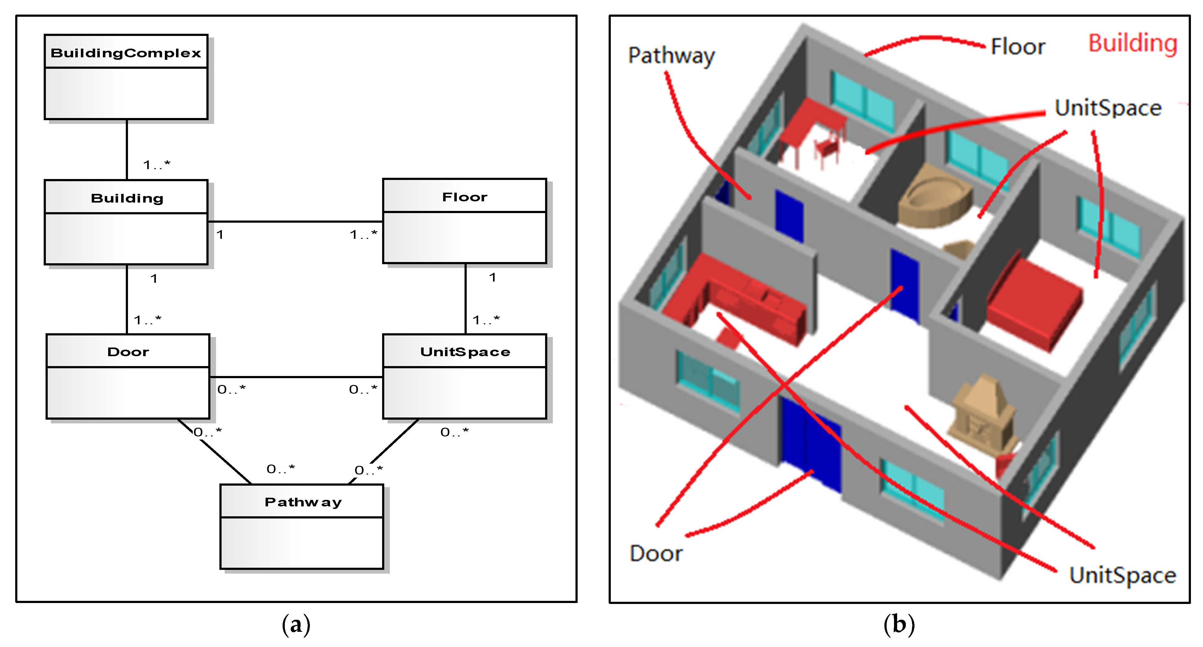
2.3.3. OGC CityGML and IndoorGML

In the last decades, 3D city models have been used in dozens of application domains for diverse purposes, such as urban planning, facility management, 3D cadaster, energy demand estimation, aiding positioning and navigation, and emergency response, etc. [47]. CityGML is an open encoding standard of the Open Geospatial Consortium (OGC) for representation, storage, and exchange of semantic 3D city models based on the Geography Markup Language version 3.1.1 (GML3) [82]. Over a decade of development, CityGML is generally considered as the most internationally widespread open reference standard for 3D city model management, storage, and exchange, partly because of its characteristics, such as [82]:
  • Modularization
The CityGML data model is thematically decomposed into a core module and thematic extension modules. The core module comprises the basic concepts and components of the CityGML data model, and based on the core module, each extension covers a specific thematic field of virtual 3D city models. CityGML 2.0 introduces 13 thematic extension modules, i.e., Appearance, Bridge, Building, CityFurniture, CityObjectGroup, Generics, LandUse, Relief, Transportation, Tunnel, Vegetation, WaterBody, and TexturedSurface. These modules contain one or more classes representing specific types of objects, and the most used module in practice is the Building module [83].
  • Application Domain Extensions (ADE)
Even though CityGML modularization provide a mechanism to extend core module, the advent of dozens of applications still requires some additional information that is not readily available in the CityGML data model, but it is beyond the scope of current standard version. Thereby, one of the significant requirements is to specify extensions to the existing CityGML data model. Basically, there are two ways to support augmenting the CityGML data model: through extending generic objects and attributes, and mainly using the ADE mechanism [84]. The ADE mechanism is orthogonally aligned with the modularization approach in CityGML, but it has to be defined in an extra XML schema definition file with its own namespace. Two examples for ADEs (i.e., Noise Immission Simulation and Ubiquitous Network) are included in the CityGML 2.0 standard [82]. Biljecki et al. [84] presented a survey of many more ADEs developed for a variety of purposes.
  • Multi-scale modelling
CityGML supports five different levels of detail (LOD), that is, level LOD0 is essentially 2.5D Digital Terrain Model (DTM) over which an aerial image or a map may be draped; LOD1 is the well-known block model comprising prismatic buildings with flat roof structures; building in LOD2 has differentiated roof structures and thematically differentiated boundary surfaces; LOD3 denotes architectural models with detailed wall and roof structures potentially including doors and windows; while, LOD4 completes a LOD3 model by adding interior structures (for example, rooms, interior doors, stairs, and furniture) for buildings [82]. Each object in CityGML can have a different representation for every LOD, thus making possible efficient visualization and data analysis to meet different application requirements.
  • Other characteristics
Other characteristics of CityGML are introduced in [82], including coherent semantical-geometrical modelling, closure surfaces, Terrain Intersection Curve (TIC), code lists for enumerative attributes, external references, city object groups, appearances, prototypic objects/scene graph concepts, and generic city objects and attributes. For example, semantical-geometrical modelling is one of the most important design principles for CityGML as real-world entities are represented by features with geometry and attributes, as well as relations and aggregation hierarchies between features.
Although the CityGML LoD 4 is capable of describing indoor objects such as ceilings, windows, doors, furniture, etc., and indoor ADE can include indoor space features and indoor facility features for indoor facility management [85], the OGC IndoorGML standard aims to support location-based services for indoor navigation; however, CityGML has some missing elements for indoor applications, particularly indoor navigation. In this respect, indoorGML is a complementary standard to CityGML, KML, and IFC [86]. Based on GML 3.2.1, IndoorGML provides a cellular and structured space model, which supports semantic, geometric, topological, and multi-layered representation of indoor environments. While the basic concepts of IndoorGML are discussed in detail in [87,88], Ryoo et al. [11] presented a comparison between CityGML and IndoorGML; and, Kim et al. [89] discussed the issues on the integration of IndoorGML and CityGML LoD 4 by two methods: automatic derivation of IndoorGML data from CityGML LoD 4 data set and external references from IndoorGML instance to an object in CityGML data. Future changes and improvements are being considered in the IndoorGML2.0 standard proposal [90].

2.3.4. IEEE MDR

The requirements raised by robot navigation tasks in 2D indoor and outdoor environments may include: map quality in terms of metric accuracy, probabilistic behavior of robot navigation, and capability of handling metric and topological maps [91]. In order to satisfy robot navigation requirements, the IEEE Robotics & Automation Society (RAS) developed a standard for Robot Map Data Representation (MDR) for navigation, which specified data models and data formats for two-dimensional (2D) metric and topological maps.
The IEEE 1873–2015 standard defines a global map concept, considered as a tree consisting of a collection of 2D local maps. The local map, which is either a metric or a topological map, is represented by nodes and arcs, where nodes represent local maps and arcs represent the relations (for example, transformation of coordinate system) between two local maps. A metric map may contain grid maps and geometric maps, where a grid map decomposes the representation of an environment into square cells that constitute atomic pieces of information, and a geometric map comprises a list of continuous geometric features. A topological map represents an environment in the form of a graph consisting of a set of nodes and edges connecting them [92]. This standard also specifies the XML implementation according to this data model. More information about the XML data format in practice can be found in [91,92].

2.3.5. IFC of BuildingSMART

The Industry Foundation Classes (IFC), originally the buildingSMART open standard for BIM, has been adapted as the ISO 16739 international standard (ISO 16739-1:2018 [93]), which specifies a data schema (represented as an EXPRESS schema) and an exchange file format structure. The exchange format consists of definitions that are required during the life cycle phases of buildings and that are required by the various disciplines involved within the life cycle phases. The IFC includes several hundred entity classes in an entity-relationship model, which supports the semantic description and geometric representation of typical construction elements and their relationships.
Supported by the GeoBIM benchmark project, Noardo et al. [94] presented a specific study of the interoperability of the IFC standard, testing 33 software packages that support the IFC and focusing on the themes of georeferencing, semantics, and geometry. The general functionalities include visualization, editing, query, analysis, and export possibilities, and so on. However, the authors did not comment on the applicability of the IFC standard for indoor map representation and navigation. Liu et al. [49], however, presented a survey of indoor navigation approaches, applications, and solutions supported by IFC. These survey results indicate that the most active research direction is to generate the navigation models from IFC data. Another group of researchers have investigated the transformation from IFC to other different data models and their integrations. For example, Lim et al. [95] presented a graph transformation approach from IFC to CityGML, Linet al. [96] introduced a method to cope with path planning for 3D indoor space through an IFC file as input, and Gilbert et al. [97] discussed some of the problems that occur when integrating three built environment standards: CityGML, IFC, and LandInfra.

2.3.6. Other Standards and Formats

Besides these standards for indoor positioning, mapping, and navigation, several other standards and formats are also relevant to indoor applications, including the OGC Land and Infrastructure standard (LandInfra) aimed at land and civil engineering infrastructure facilities representation [98]; the green building data model (gbXML) (https://www.gbxml.org, accessed on 3 March 2022) aimed at the representation of buildings for energy analysis; the Indoor Map Data Format (IMDF), published by Apple and OGC, that provides the definitions of selected indoor feature types and certain venue types such as airports, malls, and train station based on GeoJSON [99]; the OSM for indoor environments [100], and so on.
Hopefully, a group of ISO TC211 Geographic Information standards, which specify methods, tools, and services for geographic data management, acquisition, processing, analysis, access, and presenting and transferring geographic information between different users, systems and locations, may be extended and utilized in indoor environments, for example:
  • ISO 19116:2019 Positioning services, which specifies the data structures and contents of an interface between position-providing device(s) and position-using devices(s) so that position information can be interpreted unambiguously.
  • ISO 19133:2005 LBS—Tracking and navigation, which describes the data types, and operations associated with those types, for the implementation of tracking and navigation services.
  • ISO 19134:2007 LBS—Multimodal routing and navigation, which specifies the data types and their associated operations for the implementation of multimodal location-based services for routing and navigation.
  • ISO 19147:2015 Transfer Nodes, which specifies the data types and code lists associated with those types for the implementation of transfer nodes and their services in transport modelling and location-based services.

3. Requirements and Architecture of IPMN Standards System

Although research on indoor positioning, mapping, and navigation show great advances over the past two decades, as observed from literature, there are still several technical and non-technical challenges in the development of LBS, including indoor positioning, availability of indoor maps, and location privacy [4]. In terms of positioning technologies, reliable, accurate, inexpensive, seamless, indoor/outdoor positioning is needed for many LBS applications, particularly concerning safety and security applications, which are potentially life-saving such as emergency services. For indoor maps, issues such as the complexity for modeling and analysis, contextual information inference, data storage, and streaming, together with privacy concerns comprise quite a challenge considering map coverage and availability of the content [4].
The biggest challenge is lack of standardization [5], even though several IPMN standards have been published, as mentioned previously. In particular, there is no standard that can serve as a guide for designing localization and proximity techniques [5]. Current IPMN standards have been developed by various SDOs for specific purposes; for example, ISO 17438—developed by ISO Technical Committee (TC) 204—identifies the requirements and use cases for ITS navigation, and they do not specify either indoor positioning technologies and reference data or indoor map formats. Furthermore, the requirements and use cases may vary from one application (for example, safety and security applications) to another (for example, ITS or assets management).
From the perspective of IPMN standards and system theory, this paper focuses on the re-thinking of the IPMN standards system. First of all, we need to study the basic information theories, concepts, and models behind the existing and emerging IPMN technologies, asking for instance, such as what is the underlying theory of IPMN? Secondly, from the viewpoint of engineering, can current technologies, standards and systems meet the requirements of most applications? And finally, what can we do to tackle the IPMN problem in the coming years? Therefore, regarding the whole process of IPMN, which includes positioning equipment deployment, indoor map data acquisition and organization, indoor and outdoor seamless positioning and navigation services, and testing and evaluation, we summarize the IPMN requirements as follows.
  • Positioning device deployment. Indoor positioning technology can be divided as one requiring external equipment and the other, device-free. When utilizing external equipment, such as WIFI, as positioning method, deployment of equipment in indoor scene is needed in advance. Standardization in this stage is required in choosing a deployment method and the equipment and testing method suitable for indoor environments.
  • Indoor map data acquisition and organization. Indoor positioning cannot be separated from the visualization of indoor scenes. First, indoor map data models must be built to express indoor scenes explicitly. Second, standards for data acquisition and organization are required because indoor maps are usually limited by wireless network transmission rates and mobile network terminal resolution. In addition, map visualization of large-scale indoor spaces should consider the expression of symbols, color, and semantic information, which also needs relevant standards.
  • Seamless indoor and outdoor positioning and navigation services. In large-scale applications, only indoor positioning is not of practical significance. When the environment of pedestrians switches from indoors to outdoors, the corresponding location method, map data, and coordinate system should be switched accordingly, meaning that there must be provision of standards for these transformations. For the final development of an integrated multi-mode indoor positioning systems, software and related protocol standards are required. To achieve navigation, standards for navigation models are a requirement.
  • Testing and evaluation. The last stage is testing and evaluating accuracy and cost of positioning technologies. A consistency test is also required for software development. Both of the tests should have standards as guidance.
Based on these considerations, in this paper, we propose a standard system architecture, composed of four layers: the basic general layer, the data layer, the application layer, and the environment and software layer. As shown in Figure 2, the general class includes terms, pattern language, reference models, coordinate reference system, and consistency test. The data sources class includes metadata, indoor map data acquisition, data models, resource catalog, database building and updating. the application service class includes information transmission and exchange, visualization, SDK interface, services, and products. The environment and tools class includes deployment of positioning infrastructure and software. The standard system will intersect, coordinate, and share with other related standard systems, such as RTLS, surveying and mapping geographic information standards and smart city standards.
In this architecture, there are inertial connections between each class. For example, visualizations in an application service class should be based on the data model in the data sources class. The basic general class is the basis of this system framework, and the data sources class and application service class are the main body of this standard system. The environment and tool class provide guarantees for the three classes. To improve the rationality, coordination and integrity of the system, some of the standards are strengthened on the basis of existing standards.
At the present stage, we provide a hybrid indoor positioning system architecture, two draft standards for the indoor map models, core information models, and navigation information standards, detailed in Section 4.

4. Our Research on IPMN Standards

Although there are IPMN standards developed by different SDOs, the new indoor positioning, mapping, and navigation technologies, such as 5G, IoT, smart cities and digital twins, IPS is continuously evolving. Our work was focused on the indoor intelligent hybrid positioning and GIS technology with high availability and accuracy project, which began in the year of 2016 and it is supported by the National Key Research and Development Program of China. The goal of our research is to design a hybrid indoor positioning system architecture, develop IPMN standards, and integrate various indoor positioning technologies and GIS.

4.1. Hybrid Indoor Positioning System Architecture

Our IPMN system architecture, as shown in Figure 3, is very similar to the indoor navigation architecture for ITS. Typically, an IPMN system contains a backend layer, which represents different servers in the cloud computing environment, and a client layer, which represents the applications for smartphones or mobile robotic devices. Large data, such as static indoor map data, positioning fingerprints database, containing all kinds of information (sensors, energy efficiency, etc.) about smartphones, and so on, should be stored on the backend side and should be updated frequently. The client can download needed data when it generates coordinates or runs a path-finding algorithm using various positioning and GIS technologies. Sometimes, a client needs to update the device location to the server for monitoring or tracking services. The key characteristic of our architecture is that the GIS technologies, and functionalities such as semantic analysis, are integrated into the individual positioning technology for enhanced accuracy and reliable positioning.
In this paper, we discussed the standards for the architecture. We classified the standards used in this architecture into three parts:
  • Standards for indoor map data.
  • Standards for positioning technologies.
  • Standards for navigation service.
In the following sub-section, we will briefly discuss some standards used for our project, including the:
  • Content model for indoor mapping.
  • Data collection for indoor maps.
  • GIS model for indoor spatial data.
  • Indoor map symbols.
  • Specification for digital indoor map products.
  • Multi-source fusion positioning data interfaces.
  • Seamless cooperative positioning service interfaces.

4.2. Standards for Indoor Map Data

4.2.1. Content Model for Indoor Mapping

High-accuracy indoor map data plays an important role in the indoor navigation applications, for example, some positioning technologies can use the semantic information from indoor maps to correct the accumulated location bias, so many standards have been developed to specify the map data collection procedures and methods, data formats, data models, representations and symbology, web map services, etc. Indoor map data can be collected using SLAM, Lidar, traditional total station survey, or automatically produced from CAD building drawings and floor plan images. However, we first need to determine the elements that should be contained in the indoor map for a specific application. This led to a standard entitled the “content model for indoor mapping,” which specifies the basic conceptual, content, and topological models for indoor mapping. The purpose of this standard is to provide common understanding and sharing of indoor map data content for indoor map elements when collecting data, creating database, and modeling spatial relationships.
The conceptual model for indoor mapping can be described by the terms BuildingComplex, Building, Floor, Door, UnitSpace, and Pathway, as shown in Figure 4. BuildingComplex usually corresponds to a large area of interest, consisting of heterogeneous buildings. The concept of building is straightforward and comprehensive.
Based on the conceptual model for indoor maps, the content model is given in the form of UML, as in Figure 5, which specifies the content and mandatory attributes required to describe an element in a building. However, the basic information may be inadequate for some navigation or tracking applications. Under these circumstances, users can extend the content model, for example, a navigation information model can be derived from navigation application scenarios, as shown in Figure 6.
Some specifications matching the content model were also developed in our project, including (1) specification for data collection of indoor maps—Part1: floor plan, (2) specification for GIS model of indoor spatial data, (3) indoor map symbols for general geospatial elements, and (4) technical specifications for digital indoor map production.

4.2.2. Data Collection for Indoor Maps

Several methods, such as SLAM, Lidar, and traditional total station surveys can be used for data collection of indoor maps. Indoor maps can also be produced automatically at low cost by extracting indoor elements from the existing floor plans, which are usually in the format of CAD drawings. This specification presents a procedure and detailed techniques to obtain digital indoor maps from existing floor plan, as shown in Figure 7.
The key process in Figure 7 is entity extraction and handling element geometry with a priori knowledge. Figure 8 shows some examples of element geometry extraction.
This approach can quickly generate indoor maps in accordance with a content model at very low cost, especially in the scenarios where indoor surveying is prohibited.

4.2.3. GIS Model for Indoor Spatial Data

Although GIS models and spatial analysis are widely used in outdoor settings, there are some limitations for indoor GIS due to complicated and isomeric structures of indoor elements. This specification frames the indoor GIS model, which is somewhat different from the existing GIS model in terms of data organization, management, and representation. Figure 9 shows the basic indoor GIS model, which mainly consists of three parts. Firstly, indoor spatial data are organized and managed according to the content model, each core element is grouped or classified into logical layers. Secondly, the geometry representation should support 2D, 2.5D, and 3D coordinates, and furthermore, time or dynamic properties of elements should be considered for spatiotemporal analysis. Indoor spatial data can be stored, transferred or exchanged with MDR, Indoor GML, and other indoor map data formats. Lastly, topological relationships can be derived from the geometry data or cached for immediate pathway finding. From an overall view, this GIS model for indoor spatial data conforms with those for outdoor data, however, the existing commercial or open-source GIS software hardly supports indoor spatial data.

4.2.4. Indoor Map Symbols

This specification provides symbols, labels, styles and rules used for indoor maps, and easily understood. So, we merely list some symbols in Table 1.

4.2.5. Specification for Digital Indoor Map Products

This specification determines how indoor maps can become authorized digital indoor map production, public or government assets. It specifies the basic requirements for indoor map products, just like traditional digital outdoor map products, such as Digital Line Graphic (DLG) products.

4.3. Multi-Source Fusion Positioning Data Interface

This kind of standard specifies the data interface among positioning engines. Usually, there are two kinds of positioning engines, one is the main engine, which integrates positioning results from different technologies, and the others are called sub-engines. Each sub-engine involves typically an individual technology, as illustrated in Figure 10.
The protocol for information exchange between two engines is based on request/response mechanism, but not specified with concrete protocols in this standard; however, both the sensor data and the positioning results are specified in detail.
Related standards specified the data structure, format, type, and etc. of individual positioning technologies, such as GB/T 38627-2020 [102], specify the magnetic positioning data interface. Other indoor positioning standards, such as visual positioning data interface, protocols for information superposition based on ubiquitous location, and so on are planned or are under development.

4.4. Seamless Cooperative Positioning Service Interface

Based on the integrated hybrid indoor positioning system architecture (see Figure 3), the standard for indoor and outdoor multi-mode cooperative positioning service interface [103] can be used in some scenarios that applications need to get the device locations from the data server. This standard specifies the basic service elements and service interfaces for seamless collaborative positioning, and designed according to the OGC Web Services Common Standard [104] and specifies five operations as in Figure 11.
For a localization system or service, the service should retrieve adequate information for applications, including the service provider, coordinate reference system, quality information, positioning technology type, and potential service exceptions. The service metadata is also specified in this standard, as detailed in Figure 12.
Similarly, applications can get indoor maps or entities through the OGC WMS [105] or WFS [106] standards.

5. Conclusions

The emergence of indoor based applications and markets promotes advances in IPMN technologies and standards. Different techniques, technologies, mechanisms, methodologies, systems, platforms, and standards have been developed for indoor localization services and applications. However, IPMN applications still face several technical and non-technical challenges, such as quality of positioning service, availability of indoor maps, and location privacy. Currently there is no proposed solution that can satisfy all indoor application requirements. One of the biggest challenges is a lack of standardization. The existing IPMN standards published by different SDOs, such as ISO, IEEE, and OGC differ from each other, and they focus on different viewpoints of indoor positioning, mapping, and navigation, such as automatic identification and data capture techniques (RTLS), communications technologies in transportation (ITS), city and indoor models (CityGML and IndoorGML), building information model (BIM), and robot navigation (MDR).
This paper updates the review of indoor positioning and mapping technologies and standards. As we re-think the results, we present an architecture for IPMN, and standards based on the architecture for our project. We found by our project experience that the coordinate IPMN standards system needs to be formed from the concepts, models, and technologies to the industrial application schemas. Thus, we proposed several standards including hybrid indoor positioning, content model for indoor map, data collection, GIS model, symbols, and indoor positioning service. The main purpose here is to provide readers and researchers with guidance to IPMN technologies and standards; and, for standard developers to have a way to develop complementary standards to form the backbone for an integrated IPMN standards system.

Author Contributions

Conceptualization and standards review, Y.D.; indoor positioning methodology review, H.A.; writing—original draft preparation, Z.D.; content model for indoor maps, W.G.; data collection standard, J.S. All authors have read and agreed to the published version of the manuscript.

Funding

This research was funded by the National Key Research and Development Programs, grant number 2016YFB0502201, and National Natural Science Foundation of China, grant number 61971316.

Institutional Review Board Statement

Not applicable.

Informed Consent Statement

Not applicable.

Data Availability Statement

Not applicable.

Conflicts of Interest

The authors declare no conflict of interest.

References

  1. Li, K.-J.; Zlatanova, S.; Torres-Sospedra, J.; Perez-Navarro, A.; Laoudias, C.; Moreira, A. Survey on Indoor Map Standards and Formats. In Proceedings of the 2019 International Conference on Indoor Positioning and Indoor Navigation (IPIN), Pisa, Italy, 30 September–3 October 2019; pp. 1–8. [Google Scholar]
  2. Smith, G.S. Technavio Indoor Positioning and Indoor Navigation Market by Application and Geography—Forecast and Analysis 2021–2025. Available online: https://www.technavio.com/report/indoor-positioning-and-indoor-navigation-market-industry-analysis (accessed on 3 March 2022).
  3. Tomažič, S. Indoor Positioning and Navigation. Sensors 2021, 21, 4793. [Google Scholar] [CrossRef] [PubMed]
  4. Basiri, A.; Lohan, E.S.; Moore, T.; Winstanley, A.; Peltola, P.; Hill, C.; Amirian, P.; Figueiredo e Silva, P. Indoor Location Based Services Challenges, Requirements and Usability of Current Solutions. Comput. Sci. Rev. 2017, 24, 1–12. [Google Scholar] [CrossRef] [Green Version]
  5. Zafari, F.; Gkelias, A.; Leung, K. A Survey of Indoor Localization Systems and Technologies. IEEE Commun. Surv. Tutor. 2019, 21, 2568–2599. [Google Scholar] [CrossRef] [Green Version]
  6. Mendoza-Silva, G.M.; Torres-Sospedra, J.; Huerta, J. A Meta-Review of Indoor Positioning Systems. Sensors 2019, 19, 4507. [Google Scholar] [CrossRef] [PubMed] [Green Version]
  7. Simões, W.C.S.S.; Machado, G.S.; Sales, A.M.A.; de Lucena, M.M.; Jazdi, N.; de Lucena, V.F. A Review of Technologies and Techniques for Indoor Navigation Systems for the Visually Impaired. Sensors 2020, 20, 3935. [Google Scholar] [CrossRef] [PubMed]
  8. Gunduz, M.; Isikdag, U.; Basaraner, M. A Review of Recent Research in Indoor Modelling & Mapping. Int. Arch. Photogramm. Remote Sens. Spat. Inf. Sci. 2016, XLI-B4, 289–294. [Google Scholar] [CrossRef] [Green Version]
  9. Teixeira, H.; Magalhães, A.; Ramalho, A.; de Pina, M.F.; Gonçalves, H. Indoor Environments and Geographical Information Systems: A Systematic Literature Review. SAGE Open 2021, 11, 215824402110503. [Google Scholar] [CrossRef]
  10. Nossum, A.S. Developing a Framework for Describing and Comparing Indoor Maps. Cartogr. J. 2013, 50, 218–224. [Google Scholar] [CrossRef]
  11. Ryoo, H.-G.; Kim, T.; Li, K.-J. Comparison between Two OGC Standards for Indoor Space: CityGML and IndoorGML. In Proceedings of the Seventh ACM SIGSPATIAL International Workshop on Indoor Spatial Awareness, Bellevue, WA, USA, 3 November 2015; pp. 1–8. [Google Scholar]
  12. Lluvia, I.; Lazkano, E.; Ansuategi, A. Active Mapping and Robot Exploration: A Survey. Sensors 2021, 21, 2445. [Google Scholar] [CrossRef]
  13. ISO 17438-4:2019; Intelligent Transport Systems—Indoor Navigation for Personal and Vehicle ITS Station—Part 4: Requirements and Specifications for Interface between Personal/Vehicle and Central ITS Stations. International Organization for Standardization: Geneva, Switzerland, 2019.
  14. Sakpere, W.; Adeyeye Oshin, M.; Mlitwa, N.B. A State-of-the-Art Survey of Indoor Positioning and Navigation Systems and Technologies. S. Afr. Comput. J. 2017, 29, 145–197. [Google Scholar] [CrossRef] [Green Version]
  15. Brena, R.F.; García-Vázquez, J.P.; Galván-Tejada, C.E.; Muñoz-Rodriguez, D.; Vargas-Rosales, C.; Fangmeyer, J. Evolution of Indoor Positioning Technologies: A Survey. J. Sens. 2017, 2017, 1–21. [Google Scholar] [CrossRef]
  16. Yassin, A.; Nasser, Y.; Awad, M.; Al-Dubai, A.; Liu, R.; Yuen, C.; Raulefs, R.; Aboutanios, E. Recent Advances in Indoor Localization: A Survey on Theoretical Approaches and Applications. IEEE Commun. Surv. Tutor. 2017, 19, 1327–1346. [Google Scholar] [CrossRef] [Green Version]
  17. Kunhoth, J.; Karkar, A.; Al-Maadeed, S.; Al-Ali, A. Indoor Positioning and Wayfinding Systems: A Survey. Hum. Cent. Comput. Inf. Sci. 2020, 10, 18. [Google Scholar] [CrossRef]
  18. Mautz, R. Overview of Current Indoor Positioning Systems. Geod. Cartogr. 2009, 35, 18–22. [Google Scholar] [CrossRef]
  19. Al-Ammar, M.A.; Alhadhrami, S.; Al-Salman, A.; Alarifi, A.; Al-Khalifa, H.S.; Alnafessah, A.; Alsaleh, M. Comparative Survey of Indoor Positioning Technologies, Techniques, and Algorithms. In Proceedings of the 2014 International Conference on Cyberworlds, Santander, Spain, 6–8 October 2014; pp. 245–252. [Google Scholar]
  20. Ferreira, A.F.G.; Fernandes, D.M.A.; Catarino, A.P.; Monteiro, J.L. Localization and Positioning Systems for Emergency Responders: A Survey. IEEE Commun. Surv. Tutor. 2017, 19, 2836–2870. [Google Scholar] [CrossRef]
  21. Khelifi, F.; Bradai, A.; Benslimane, A.; Rawat, P.; Atri, M. A Survey of Localization Systems in Internet of Things. Mob. Netw. Appl. 2019, 24, 761–785. [Google Scholar] [CrossRef]
  22. Liu, Z.; Dai, W.; Win, M.Z. Mercury: An Infrastructure-Free System for Network Localization and Navigation. IEEE Trans. Mob. Comput. 2018, 17, 1119–1133. [Google Scholar] [CrossRef]
  23. He, S.; Chan, S.-H.G. Wi-Fi Fingerprint-Based Indoor Positioning: Recent Advances and Comparisons. IEEE Commun. Surv. Tutor. 2016, 18, 466–490. [Google Scholar] [CrossRef]
  24. Xiao, J.; Zhou, Z.; Yi, Y.; Ni, L.M. A Survey on Wireless Indoor Localization from the Device Perspective. ACM Comput. Surv. 2016, 49, 1–31. [Google Scholar] [CrossRef]
  25. Lymberopoulos, D.; Liu, J.; Yang, X.; Choudhury, R.R.; Handziski, V.; Sen, S. A Realistic Evaluation and Comparison of Indoor Location Technologies: Experiences and Lessons Learned. In Proceedings of the 14th International Conference on Information Processing in Sensor Networks, Seattle, WA, USA, 13 April 2015; pp. 178–189. [Google Scholar]
  26. Singh, S.P.; Sharma, S.C. A Survey on Cluster Based Routing Protocols in Wireless Sensor Networks. Procedia Comput. Sci. 2015, 45, 687–695. [Google Scholar] [CrossRef] [Green Version]
  27. Wu, Y.; Zhu, H.-B.; Du, Q.-X.; Tang, S.-M. A Survey of the Research Status of Pedestrian Dead Reckoning Systems Based on Inertial Sensors. Int. J. Autom. Comput. 2019, 16, 65–83. [Google Scholar] [CrossRef]
  28. Chen, R.; Chen, L. Smartphone-Based Indoor Positioning Technologies. In Urban Informatics; Shi, W., Goodchild, M.F., Batty, M., Kwan, M.-P., Zhang, A., Eds.; The Urban Book Series; Springer: Singapore, 2021; pp. 467–490. ISBN 9789811589829. [Google Scholar]
  29. Van Haute, T.; De Poorter, E.; Crombez, P.; Lemic, F.; Handziski, V.; Wirström, N.; Wolisz, A.; Voigt, T.; Moerman, I. Performance Analysis of Multiple Indoor Positioning Systems in a Healthcare Environment. Int. J. Health Geogr. 2016, 15, 7. [Google Scholar] [CrossRef] [PubMed] [Green Version]
  30. Saeed, N.; Nam, H.; Al-Naffouri, T.Y.; Alouini, M.-S. A State-of-the-Art Survey on Multidimensional Scaling-Based Localization Techniques. IEEE Commun. Surv. Tutor. 2019, 21, 3565–3583. [Google Scholar] [CrossRef] [Green Version]
  31. Boudani, B.E.; Kanaris, L.; Kokkinis, A.; Chrysoulas, C.; Dagiuklas, T.; Stavrou, S. Positioning as Service for 5G IoT Networks. In Proceedings of the 2021 Telecoms Conference (ConfTELE), Leiria, Portugal, 11 February 2021; pp. 1–6. [Google Scholar]
  32. Chen, L.; Zhou, X.; Chen, F.; Yang, L.-L.; Chen, R. Carrier Phase Ranging for Indoor Positioning with 5G NR Signals. IEEE Internet Things J. 2021. Available online: https://ieeexplore.ieee.org/document/9601204 (accessed on 3 March 2022). [CrossRef]
  33. Boudani, B.E.; Kanaris, L.; Kokkinis, A.; Kyriacou, M.; Chrysoulas, C.; Stavrou, S.; Dagiuklas, T. Implementing Deep Learning Techniques in 5G IoT Networks for 3D Indoor Positioning: DELTA (DeEp Learning-Based Co-OperaTive Architecture). Sensors 2020, 20, 5495. [Google Scholar] [CrossRef]
  34. Horsmanheimo, S.; Lembo, S.; Tuomimaki, L.; Huilla, S.; Honkamaa, P.; Laukkanen, M.; Kemppi, P. Indoor Positioning Platform to Support 5G Location Based Services. In Proceedings of the 2019 IEEE International Conference on Communications Workshops (ICC Workshops), Shanghai, China, 20–24 May 2019; pp. 1–6. [Google Scholar]
  35. Kapovits, A.; Gavras, A.; Cosmas, J.; Ghoraishi, M.; Li, X.; Zhang, Y. Delivery of 5G Services Indoors—The Wireless Wire Challenge and Solutions. 2021. Available online: https://zenodo.org/record/4280750#.YiXYXGhByMo (accessed on 3 March 2022).
  36. Keller, F.; Sternberg, H. Multi-Sensor Platform for Indoor Mobile Mapping: System Calibration and Using a Total Station for Indoor Applications. Remote Sens. 2013, 5, 5805–5824. [Google Scholar] [CrossRef] [Green Version]
  37. Zlatanova, S.; Sithole, G.; Nakagawa, M.; Zhu, Q. Problems In Indoor Mapping and Modelling. Int. Arch. Photogramm. Remote Sens. Spat. Inf. Sci. 2013, XL-4/W4, 63–68. [Google Scholar] [CrossRef] [Green Version]
  38. Otero, R.; Lagüela, S.; Garrido, I.; Arias, P. Mobile Indoor Mapping Technologies: A Review. Autom. Constr. 2020, 120, 103399. [Google Scholar] [CrossRef]
  39. Di Stefano, F.; Chiappini, S.; Gorreja, A.; Balestra, M.; Pierdicca, R. Mobile 3D Scan LiDAR: A Literature Review. Geomat. Nat. Hazards Risk 2021, 12, 2387–2429. [Google Scholar] [CrossRef]
  40. Virtanen, J.-P.; Kurkela, M.; Turppa, T.; Vaaja, M.T.; Julin, A.; Kukko, A.; Hyyppä, J.; Ahlavuo, M.; von Numers, J.E.; Haggrén, H.; et al. Depth Camera Indoor Mapping for 3D Virtual Radio Play. Photogram Rec. 2018, 33, 171–195. [Google Scholar] [CrossRef] [Green Version]
  41. Chen, Y.; Tang, J.; Jiang, C.; Zhu, L.; Lehtomäki, M.; Kaartinen, H.; Kaijaluoto, R.; Wang, Y.; Hyyppä, J.; Hyyppä, H.; et al. The Accuracy Comparison of Three Simultaneous Localization and Mapping (SLAM)-Based Indoor Mapping Technologies. Sensors 2018, 18, 3228. [Google Scholar] [CrossRef] [PubMed] [Green Version]
  42. Wu, Y.; Shang, J.; Chen, P.; Zlatanova, S.; Hu, X.; Zhou, Z. Indoor Mapping and Modeling by Parsing Floor Plan Images. Int. J. Geogr. Inf. Sci. 2021, 35, 1205–1231. [Google Scholar] [CrossRef]
  43. Khoshelham, K.; Tran, H.; Acharya, D.; Vilariño, L.D.; Kang, Z.; Dalyot, S. Results of the ISPRS Benchmark on Indoor Modelling. ISPRS Open J. Photogramm. Remote Sens. 2021, 2, 100008. [Google Scholar] [CrossRef]
  44. Afyouni, I.; Ray, C.; Claramunt, C. Spatial Models for Context-Aware Indoor Navigation Systems: A Survey. J. Spat. Inf. Sci. 2012, 1, 85–123. [Google Scholar] [CrossRef] [Green Version]
  45. Liu, X.; Wang, X.; Wright, G.; Cheng, J.; Li, X.; Liu, R. A State-of-the-Art Review on the Integration of Building Information Modeling (BIM) and Geographic Information System (GIS). ISPRS Int. J. Geo-Inf. 2017, 6, 53. [Google Scholar] [CrossRef] [Green Version]
  46. Penttilä H Describing the Changes in Architectural Information Technology to Understand Design Complexity and Free-Form Architectural Expression. J. Inf. Technol. Constr. 2006, 11, 395–408.
  47. Biljecki, F.; Stoter, J.; Ledoux, H.; Zlatanova, S.; Çöltekin, A. Applications of 3D City Models: State of the Art Review. ISPRS Int. J. Geo-Inf. 2015, 4, 2842–2889. [Google Scholar] [CrossRef] [Green Version]
  48. Chen, Q.; Chen, J.; Huang, W. Method for Generation of Indoor GIS Models Based on BIM Models to Support Adjacent Analysis of Indoor Spaces. ISPRS Int. J. Geo-Inf. 2020, 9, 508. [Google Scholar] [CrossRef]
  49. Liu, L.; Li, B.; Zlatanova, S.; van Oosterom, P. Indoor Navigation Supported by the Industry Foundation Classes (IFC): A Survey. Autom. Constr. 2021, 121, 103436. [Google Scholar] [CrossRef]
  50. Wu, B.; Zhang, S. Integration of gis and bim for indoor geovisual analytics. Int. Arch. Photogramm. Remote Sens. Spat. Inf. Sci. 2016, XLI-B2, 455–458. [Google Scholar] [CrossRef] [Green Version]
  51. Sun, Q.; Zhou, X.; Hou, D. A Simplified CityGML-Based 3D Indoor Space Model for Indoor Applications. Appl. Sci. 2020, 10, 7218. [Google Scholar] [CrossRef]
  52. Weinmann, M.; Wursthorn, S.; Weinmann, M.; Hübner, P. Efficient 3D Mapping and Modelling of Indoor Scenes with the Microsoft HoloLens: A Survey. PFG 2021, 89, 319–333. [Google Scholar] [CrossRef]
  53. Andersen, D.; Popescu, V. An AR-Guided System for Fast Image-Based Modeling of Indoor Scenes. In Proceedings of the 2018 IEEE Conference on Virtual Reality and 3D User Interfaces (VR), Reutlingen, Germany, 18–22 March 2018; pp. 501–502. [Google Scholar]
  54. Chen, J.; Clarke, K.C. Modeling Standards and File Formats for Indoor Mapping. In Proceedings of the 3rd International Conference on Geographical Information Systems Theory, Applications and Management, Porto, Portugal, 27–28 April 2017; pp. 268–275. [Google Scholar]
  55. Rácz-Szabó, A.; Ruppert, T.; Bántay, L.; Löcklin, A.; Jakab, L.; Abonyi, J. Real-Time Locating System in Production Management. Sensors 2020, 20, 6766. [Google Scholar] [CrossRef] [PubMed]
  56. ISO/IEC 24730-1:2014; Information Technology—Real-Time Locating Systems (RTLS)—Part 1: Application Programming Interface (API). International Organization for Standardization: Geneva, Switzerland, 2014.
  57. ISO/IEC 24730-2:2012; Information Technology—Real Time Locating Systems (RTLS)—Part 2: Direct Sequence Spread Spectrum (DSSS) 2,4 GHz Air Interface Protocol. International Organization for Standardization: Geneva, Switzerland, 2012.
  58. ISO/IEC 24730-21:2012; Information Technology—Real Time Locating Systems (RTLS)—Part 21: Direct Sequence Spread Spectrum (DSSS) 2,4 GHz Air Interface Protocol: Transmitters Operating with a Single Spread Code and Employing a DBPSK Data Encoding and BPSK Spreading Scheme. International Organization for Standardization: Geneva, Switzerland, 2012.
  59. ISO/IEC 24730-22:2012; Information Technology—Real Time Locating Systems (RTLS)—Part 22: Direct Sequence Spread Spectrum (DSSS) 2,4 GHz Air Interface Protocol: Transmitters Operating with Multiple Spread Codes and Employing a QPSK Data Encoding and Walsh Offset QPSK (WOQPSK) Spreading Scheme. International Organization for Standardization: Geneva, Switzerland, 2012.
  60. ISO/IEC 24730-5:2010; Information Technolog—Real-Time Locating Systems (RTLS)—Part 5: Chirp Spread Spectrum (CSS) at 2,4 GHz Air Interface. International Organization for Standardization: Geneva, Switzerland, 2012.
  61. ISO/IEC 24730-61:2013; Information Technology—Real Time Locating Systems (RTLS)—Part 61: Low Rate Pulse Repetition Frequency Ultra Wide Band (UWB) Air Interface. International Organization for Standardization: Geneva, Switzerland, 2013.
  62. ISO/IEC 24730-62:2013; Information Technology—Real Time Locating Systems (RTLS)—Part 62: High Rate Pulse Repetition Frequency Ultra Wide Band (UWB) Air Interface. International Organization for Standardization: Geneva, Switzerland, 2013.
  63. ISO/IEC 24769-2:2013; Information Technology—Real-Time Locating Systems (RTLS) Device Conformance Test Methods—Part 2: Test Methods for Air Interface Communication at 2,4 GHz. International Organization for Standardization: Geneva, Switzerland, 2013.
  64. ISO/IEC 24769-5:2012; Information Technology—Automatic Identification and Data Capture Techniques—Real Time Locating Systems (RTLS) Device Conformance Test Methods—Part 5: Test Methods for Chirp Spread Spectrum (CSS) at 2,4 GHz Air Interface. International Organization for Standardization: Geneva, Switzerland, 2012.
  65. ISO/IEC 24769-61:2015; Information Technology—Real Time Locating System (RTLS) Device Conformance Test Methods—Part 61: Low Rate Pulse Repetition Frequency Ultra Wide Band (UWB) Air Interface. International Organization for Standardization: Geneva, Switzerland, 2015.
  66. ISO/IEC 24769-62:2015; Information Technology—Real Time Locating System (RTLS) Device Conformance Test Methods—Part 62: High Rate Pulse Repetition Frequency Ultra Wide Band (UWB) Air Interface. International Organization for Standardization: Geneva, Switzerland, 2015.
  67. ISO/IEC 24770:2012; Information Technology—Real-Time Locating System (RTLS) Device Performance Test Methods—Test Methods for Air Interface Communication at 2,4 GHz. International Organization for Standardization: Geneva, Switzerland, 2012.
  68. ISO/IEC 24770-5:2019; Information Technology—Real-Time Locating System (RTLS) Device Performance Test Methods—Part 5: Test Methods for Chirp Spread Spectrum (CSS) Air Interface. International Organization for Standardization: Geneva, Switzerland, 2019.
  69. ISO/IEC 24770-61:2015; Information Technology—Real Time Locating System (RTLS) Device Performance Test Methods—Part 61: Low Rate Pulse Repetition Frequency Ultra Wide Band (UWB) Air Interface. International Organization for Standardization: Geneva, Switzerland, 2015.
  70. ISO/IEC 24770-62:2015; Information Technology—Real-Time Locating System (RTLS) Device Performance Test Methods—Part 62: High Rate Pulse Repetition Frequency Ultra Wide Band (UWB) Air Interface. International Organization for Standardization: Geneva, Switzerland, 2015.
  71. ISO/IEC 18305:2016; Information Technology—Real Time Locating Systems—Test and Evaluation of Localization and Tracking Systems. International Organization for Standardization: Geneva, Switzerland, 2016.
  72. Potorti, F.; Crivello, A.; Barsocchi, P.; Palumbo, F. Evaluation of Indoor Localisation Systems: Comments on the ISO/IEC 18305 Standard. In Proceedings of the 2018 International Conference on Indoor Positioning and Indoor Navigation (IPIN), Nantes, France, 24–27 September 2018; pp. 1–7. [Google Scholar]
  73. Market-Growth, S.; Trends, F. Mordor Intelligence Intelligent Transport Systems Market—Growth, Trends, COVID-19 Impact, and Forecasts (2021–2026). Available online: https://www.researchandmarkets.com/reports/4557725/intelligent-transport-systems-market-growth (accessed on 3 March 2022).
  74. National Research Council (U.S.). Committee for Review of the U.S. Department of Transportation’s Intelligent Transportation Systems Standards Program Standards for Intelligent Transportation Systems: Review of the Federal Program; Transportation Research Board: Washington, DC, USA, 2000; ISBN 978-0-309-06745-4. [Google Scholar]
  75. Uden, L.; Dimitrakopoulos, G.J.; Varlamis, I. (Eds.) The Future of Intelligent Transport Systems, 1st ed.; Elsevier: San Diego, CA, USA, 2020; ISBN 978-0-12-818281-9. [Google Scholar]
  76. Williams, B. Intelligent Transport Systems Standards; Artech House: Boston, UK, 2008. [Google Scholar]
  77. ISO 17438-1:2016; Intelligent Transport Systems—Indoor Navigation for Personal and Vehicle ITS Station—Part 1: General Information and Use Case Definition. International Organization for Standardization: Geneva, Switzerland, 2016.
  78. ISO 17267:2009; Intelligent Transport Systems—Navigation Systems—Application Programming Interface (API). International Organization for Standardization: Geneva, Switzerland, 2009.
  79. ISO 14825:2011; Intelligent Transport Systems—Geographic Data Files (GDF)—GDF5.0. International Organization for Standardization: Geneva, Switzerland, 2011.
  80. ISO 20524-1:2020; Intelligent Transport Systems—Geographic Data Files (GDF) GDF5.1—Part 1: Application Independent Map Data Shared between Multiple Sources. International Organization for Standardization: Geneva, Switzerland, 2020.
  81. ISO 20524-2:2020; Intelligent Transport Systems—Geographic Data Files (GDF) GDF5.1—Part 2: Map Data Used in Automated Driving Systems, Cooperative ITS, and Multi-Modal Transport. International Organization for Standardization: Geneva, Switzerland, 2020.
  82. Gröger, G.; Kolbe, T.H.; Nagel, C.; Häfele, K. OGC City Geography Markup Language (CityGML) Encoding Standard. Available online: https://www.ogc.org/standards/citygml (accessed on 3 March 2022).
  83. Noardo, F.; Arroyo Ohori, K.; Biljecki, F.; Ellul, C.; Harrie, L.; Krijnen, T.; Eriksson, H.; van Liempt, J.; Pla, M.; Ruiz, A.; et al. Reference Study of CityGML Software Support: The GeoBIM Benchmark 2019—Part II. Trans. GIS 2021, 25, 842–868. [Google Scholar] [CrossRef]
  84. Biljecki, F.; Kumar, K.; Nagel, C. CityGML Application Domain Extension (ADE): Overview of Developments. Open Geospat. Data Softw. Stand. 2018, 3, 13. [Google Scholar] [CrossRef] [Green Version]
  85. Kim, Y.; Kang, H.; Lee, J. Developing CityGML Indoor ADE to Manage Indoor Facilities. In Innovations in 3D Geo-Information Sciences; Isikdag, U., Ed.; Lecture Notes in Geoinformation and Cartography; Springer International Publishing: Cham, Switzerland, 2014; pp. 243–265. ISBN 978-3-319-00514-0. [Google Scholar]
  86. Lee, J.; Li, K.-J.; Zlatanova, S.; Kolbe, T.H.; Nagel, C.; Becker, T. OGC IndoorGML. Available online: https://docs.ogc.org/is/19-011r4/19-011r4.html (accessed on 3 March 2022).
  87. Kang, H.-K.; Li, K.-J. A Standard Indoor Spatial Data Model—OGC IndoorGML and Implementation Approaches. ISPRS Int. J. Geo-Inf. 2017, 6, 116. [Google Scholar] [CrossRef]
  88. Li, K.-J.; Conti, G.; Konstantinidis, E.; Zlatanova, S.; Bamidis, P. OGC IndoorGML: A Standard Approach for Indoor Maps. In Geographical and Fingerprinting Data to Create Systems for Indoor Positioning and Indoor/Outdoor Navigation; Elsevier: Amsterdam, The Netherlands, 2019; pp. 187–207. ISBN 978-0-12-813189-3. [Google Scholar]
  89. Kim, J.-S.; Yoo, S.-J.; Li, K.-J. Integrating IndoorGML and CityGML for Indoor Space. In Web and Wireless Geographical Information Systems; Pfoser, D., Li, K.-J., Eds.; Lecture Notes in Computer Science; Springer: Berlin/Heidelberg, Germany, 2014; Volume 8470, pp. 184–196. ISBN 978-3-642-55333-2. [Google Scholar]
  90. Diakité, A.A.; Zlatanova, S.; Alattas, A.F.M.; Li, K.J. Towards INDOORGML 2.0: Updates and case study illustrations. Int. Arch. Photogramm. Remote Sens. Spat. Inf. Sci. 2020, XLIII-B4-2020, 337–344. [Google Scholar] [CrossRef]
  91. IEEE Robotics and Automation Society; Standing Committee for Standards; Institute of Electrical and Electronics Engineers; IEEE-SA Standards Board. IEEE Standard for Robot Map Data Representation for Navigation; IEEE: New York, NY, USA, 2015; ISBN 978-0-7381-9893-4. [Google Scholar]
  92. Amigoni, F.; Yu, W.; Andre, T.; Holz, D.; Magnusson, M.; Matteucci, M.; Moon, H.; Yokotsuka, M.; Biggs, G.; Madhavan, R. A Standard for Map Data Representation: IEEE 1873-2015 Facilitates Interoperability Between Robots. IEEE Robot. Automat. Mag. 2018, 25, 65–76. [Google Scholar] [CrossRef] [Green Version]
  93. ISO 16739-1:2018; Industry Foundation Classes (IFC) for Data Sharing in the Construction and Facility Management Industries—Part 1: Data Schema. International Organization for Standardization: Geneva, Switzerland, 2018.
  94. Noardo, F.; Krijnen, T.; Arroyo Ohori, K.; Biljecki, F.; Ellul, C.; Harrie, L.; Eriksson, H.; Polia, L.; Salheb, N.; Tauscher, H.; et al. Reference Study of IFC Software Support: The GeoBIM Benchmark 2019—Part I. Trans. GIS 2021, 25, 805–841. [Google Scholar] [CrossRef]
  95. Lim, J.; Tauscher, H.; Biljecki, F. Graph transformation rules for ifc-to-citygml attribute conversion. ISPRS Ann. Photogramm. Remote Sens. Spat. Inf. Sci. 2019, IV-4/W8, 83–90. [Google Scholar] [CrossRef] [Green Version]
  96. Lin, Y.-H.; Liu, Y.-S.; Gao, G.; Han, X.-G.; Lai, C.-Y.; Gu, M. The IFC-Based Path Planning for 3D Indoor Spaces. Adv. Eng. Inform. 2013, 27, 189–205. [Google Scholar] [CrossRef] [Green Version]
  97. Gilbert, T.; Rönsdorf, C.; Plume, J.; Simmons, S.; Nisbet, N.; Gruler, H.C.; Kolbe, T.H.; van Berlo, L.; Mercer, A. Built Environment Data Standards and Their Integration: An Analysis of IFC. CityGML and LandInfra. Available online: https://buildingsmart-1xbd3ajdayi.netdna-ssl.com/wp-content/uploads/2021/02/IDBE_Standards_Integration_v1.1_28_JAN_2021.pdf (accessed on 3 March 2022).
  98. OGC. Land and Infrastructure Conceptual Model Standard (LandInfra); Open Geospatial Consortium: Arlington, VA, USA, 2016; Available online: https://www.ogc.org/standards/landinfra (accessed on 3 March 2022).
  99. OGC. Indoor Mapping Data Format; Open Geospatial Consortium: Arlington, VA, USA, 2021; Available online: https://docs.ogc.org/cs/20-094/index.html (accessed on 3 March 2022).
  100. Goetz, M. Using Crowdsourced Indoor Geodata for the Creation of a Three-Dimensional Indoor Routing Web Application. Future Internet 2012, 4, 575–591. [Google Scholar] [CrossRef] [Green Version]
  101. GB/T 38630-2020; Information Technology—Real-Time Positioning—Multi-Source Fusion Positioning Data Interface. Standards Press of China: Beijing, China, 2020.
  102. GB/T 38627-2020; Information Technology—Real-Time Positioning—Magnetic Positioning Data Interface. Standards Press of China: Beijing, China, 2020.
  103. GB/T 35629-2017; Indoor and Outdoor Multi-Mode Cooperative Positioning Service Interface. Standards Press of China: Beijing, China, 2017.
  104. Open Geospatial Consortium. Web Services Common Standard. Available online: https://www.ogc.org/standards/common (accessed on 3 March 2022).
  105. OGC. Web Map Server Implementation Specification; Open Geospatial Consortium: Arlington, VA, USA, 2006; Available online: https://www.ogc.org/standards/wms (accessed on 3 March 2022).
  106. Open Geospatial Consortium. Web Feature Service 2.0 Interface Standard. Available online: https://www.ogc.org/standards/wfs (accessed on 3 March 2022).
Figure 1. Classification of indoor positioning techniques and technologies [14].
Standards 02 00012 g001
Figure 2. Standard system architecture.
Standards 02 00012 g002
Figure 3. A GIS integrated hybrid indoor positioning system architecture.
Standards 02 00012 g003
Figure 4. Conceptual model of indoor map. (a) elements and their relationships of indoor map, (b) an illustration of building element.
Standards 02 00012 g004
Figure 5. Content model of indoor map—Core Information Model.
Standards 02 00012 g005
Figure 6. Content model of indoor map—Navigation Information Model.
Standards 02 00012 g006
Figure 7. Procedure of digitalizing indoor map from existed floor plan.
Standards 02 00012 g007
Figure 8. Examples of element geometry extraction. (a) original floor plan, (b) door geometry extraction, (c) vertical pathway geometry extraction.
Standards 02 00012 g008
Figure 9. GIS model of indoor spatial data.
Standards 02 00012 g009
Figure 10. Multi-source fusion positioning data interface (From GB/T 38630-2020, [101]).
Standards 02 00012 g010
Figure 11. Sequence diagram of location service process (From GB/T 35629-2017 [103]).
Standards 02 00012 g011
Figure 12. Metadata of cooperative positioning service.
Standards 02 00012 g012
Table 1. Examples of indoor map symbols.
CodeNameSymbol
A.1.1exit Standards 02 00012 i001
A.1.4stair Standards 02 00012 i002
A.1.5elevator Standards 02 00012 i003
A.1.6escalator Standards 02 00012 i004
A.2.5parking Standards 02 00012 i005
A.4.1.3ATM Standards 02 00012 i006
Publisher’s Note: MDPI stays neutral with regard to jurisdictional claims in published maps and institutional affiliations.

