
Unlocking Drone Potential in the Pharma Supply Chain: A Hybrid Machine Learning and GIS Approach


Transportation, Logistics, & Finance, College of Business, North Dakota State University, P.O. Box 6050, Fargo, ND 58108-6050, USA
Standards 2023, 3(3), 283-296; https://doi.org/10.3390/standards3030021
Submission received: 17 April 2023
/
Revised: 30 May 2023
/
Accepted: 8 August 2023
/
Published: 9 August 2023
Abstract
:In major metropolitan areas, the growing levels of congestion pose a significant risk of supply chain disruptions by hindering surface transportation of commodities. To address this challenge, cargo drones are emerging as a potential mode of transport that could improve the reliability of the pharmaceutical supply chain and enhance healthcare. This study proposes a novel hybrid workflow that combines machine learning and a geographic information system to identify the fewest locations where providers can initiate cargo drone services to yield the greatest initial benefits. The results show that by starting a service in only nine metropolitan areas across four regions of the contiguous United States, drones with a robust 400-mile range can initially move more than 28% of the weight of all pharmaceuticals. The medical community, supply chain managers, and policymakers worldwide can use this workflow to make data-driven decisions about where to access the largest opportunities for pharmaceutical transport by drones. The proposed approach can inform policies and standards such as Advanced Air Mobility to help address supply chain disruptions, reduce transportation costs, and improve healthcare outcomes.
1. Introduction
The demand for pharmaceutical products will increase with population growth and increases in life expectancy because of the increased likelihood of more chronic diseases, more cases of age-related illnesses, and greater health awareness. In parallel, the increased frequency of weather events and traffic congestion is likely to result in future supply chain disruptions. This points to the need for faster, safer, more secure, and more reliable methods of transporting medical products. Conventional air cargo is faster, safer, and more secure than ground transport modes, but air cargo is much more expensive and difficult to access at busy airports and seaports [1]. Cargo drone manufacturers believe their emerging products will reduce cost and increase accessibility while retaining all the speed, safety, and security advantages of air cargo [2]. Consequently, governments and future logistic service providers are collaborating in an initiative called Advanced Air Mobility (AAM) to create a standard for the safe integration of drones into the commercial air space [3].
Analysts expect that the market for cargo drones will be $58 billion by 2035 [4]. Several factors have motivated the development of cargo drone technology. Cargo drones can increase accessibility to locations that are difficult to reach by roads and offer higher throughput from greater vehicle utilization and swarming capabilities [5]. The ability to autonomously control a drone swarm, enabled by machine vision, artificial intelligence, and advanced cellular communications, increases capacity and removes the expense of human operators [6]. Mode shift from trucks to electrified cargo drones can reduce greenhouse gas emissions [7]. In particular, shifting cargo from trucks to drones can improve the speed and reliability of deliveries by avoiding road traffic disruptions, such as incidents, congestion, construction, and accumulations from inclement weather. Additionally, shifting cargo away from heavy truck traffic will help to extend the life of the surface transportation infrastructure.
Supply chain disruptions as experienced during the 2020 global pandemic spotlighted the risk of delivering medical products that are critical to maintaining human health. Consequently, companies turned to the use of drones for “last-mile” deliveries. However, only a few locations in the world used drones to deliver medical products, such as blood, vaccine, and human organs [8]. However, whilst such applications discuss last-mile deliveries to end-users, there has been a lack of research to assess the potential benefits of using drones for “middle-mile” deliveries to complete the logistical chain [9]. Therefore, the goal of this research is to quantify the opportunity for drones to transport pharmaceutical products between hubs (middle mile deliveries) to reduce risks from potential ground traffic disruptions. The objective is to develop a data-driven analytical workflow that can identify the fewest metropolitan areas where initial service deployments can yield the greatest benefits. The rationale of focusing deployments to a few regions is to minimize initial deployment costs while demonstrating large early benefits to encourage policies and standards for sustained adoption.
The organization of the rest of this paper is as follows: Section 2 reviews the literature on AAM standards development and practices in medical drone delivery. Section 3 describes the hybrid analytical workflow developed, which is a unique contribution of this research. Section 4 discusses the results of applying the workflow to relevant datasets, implications for industry standards, and limitations of the research. Section 5 concludes the research and suggests future work.
2. Literature Review
A survey of the literature reveals that there are three application areas that have been accelerating the demand for cargo drones: (1) deliveries to areas with limited accessibility, such as oil rigs, ships, remote communities, islands, mountainous regions, disaster areas, and communities with poor roads; (2) rapid delivery of emergency medical items, such as antidotes, resuscitation equipment, injections, bandages, blood, and human transplant organs; and (3) same-day or same-hour delivery of packages and food in congested urban environments. All three applications can involve both middle-mile (between hubs) and last-mile (hub to home) deliveries. The focus of this research is on opportunities to increase the speed and reduce the risk of middle-mile delivery of pharmaceuticals by using emerging cargo drone technologies. The next two subsections summarize the literature on AAM and medical drone deliveries.
2.1. Advanced Air Mobility
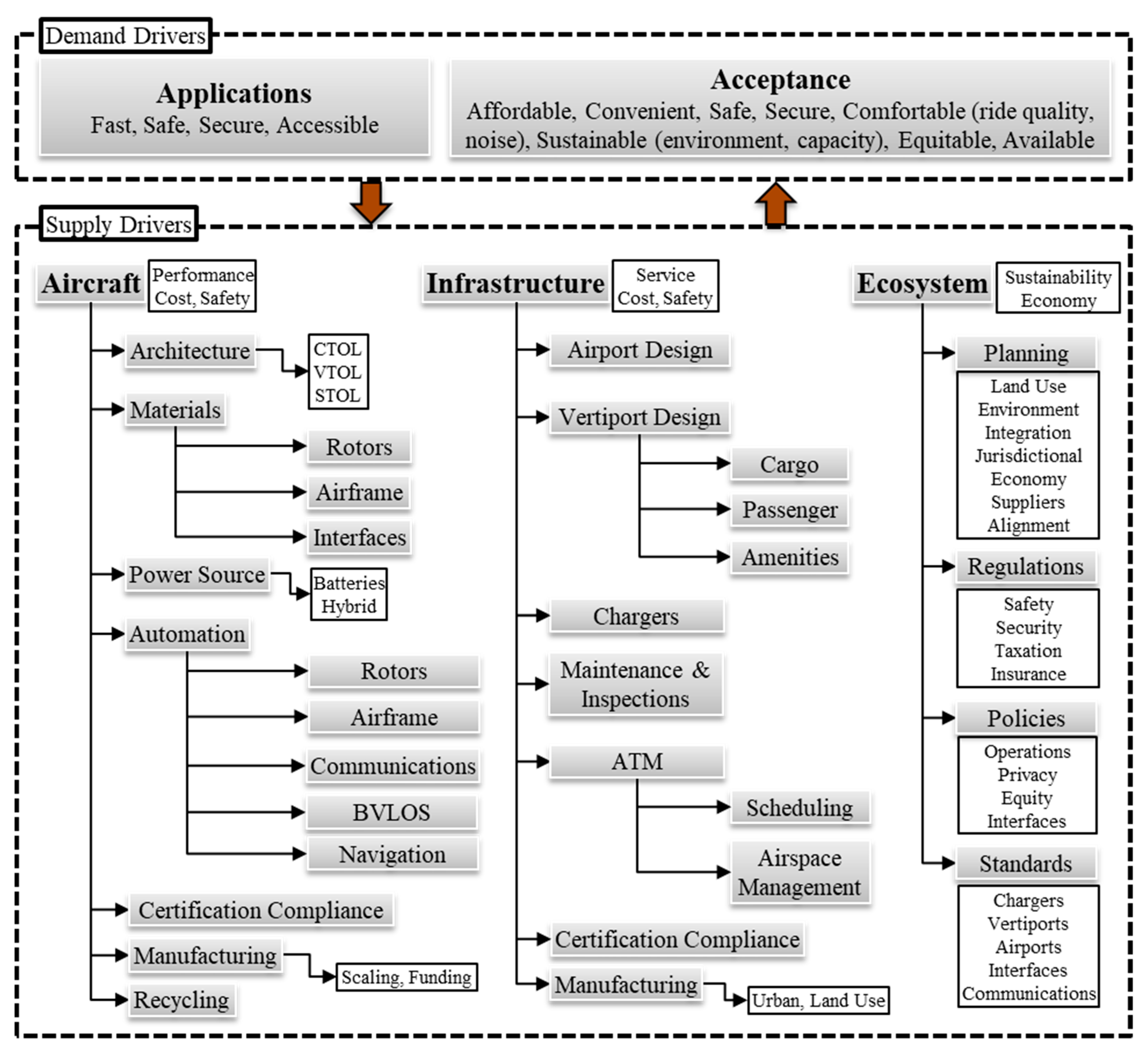
Figure 1 is the author’s empirical classification of supply and demand factors that are crucial for the success of AAM development. The two main demand drivers are applications and community acceptance. Drones are best suited for applications that demand transport that is fast, safe, secure, and accessible [10]. User acceptance increases as the transport mode becomes more affordable, convenient, safe, secure, comfortable (low noise and good ride quality), non-polluting, equitable, and available [11].
Supply drivers are within the three pillars of aircraft, infrastructure, and ecosystem. There is a complex interaction and feedback among the two demand drivers and three supply pillars. The aircraft design must meet the demand for speed, range, capacity, and safety at a cost that allows manufacturing to scale with demand [12]. Factors that affect aircraft performance and cost are the architecture type, construction material, energy density and capacity of the power source, and technologies that enable safe and automated navigation [13]. The common architecture types are conventional takeoff and landing (CTOL), vertical takeoff and landing (VTOL), and short takeoff and landing (STOL). Each architecture type trades off some performance or cost to be certifiable, operate in beyond visual line-of-sight (BVLOS) conditions in all types of weather [14], scale in manufacturing, and be recyclable [15]. The effectiveness of the terminal design, battery charging infrastructure, advanced traffic management (ATM), and integration in the environment affects safety, security, cost, convenience, accessibility, and the quality of services provided [1]. The infrastructure should also facilitate coordination with other modes of ground transportation to enable hybrid systems, such a truck-drone operations [16].
As a disruptive technology [17], enabling adoption will require the ecosystem to form partnerships with planners, suppliers, regulators, policymakers, investors, funders, and developers of relevant standards to promote interoperability, compatibility, and scalability of the planned operations and services.
2.2. Medical Drone Deliveries
The healthcare community has been evaluating the use of drones to deliver medical items, such as surgical items, laboratory samples, pharmaceuticals, vaccines, emergency equipment, and blood [18]. Early deployments narrowly focused on transporting medical products to mass casualty scenes in times of critical demand [19]. Agencies used drones to deliver rescue medicines, such as epinephrine, antiepileptics, and insulin, to natural disaster areas in Haiti (2010 earthquake), Philippines (2013 earthquake), Taiwan (2016 typhoon), and Nepal (where flooding is frequent) [20].
Several studies discussed the life-saving benefits of using drones to deliver emergency medical items. Laksham (2019) explored the potential for drones to deliver anti-venom, analgesics, antiretroviral, and malaria drugs to areas where road access is difficult [21]. Beck et al. (2020) demonstrated the feasibility of using drones to rapidly deliver adrenaline auto-injectors to treat anaphylaxis [22]. Scalea et al. (2021) demonstrated that they could integrate drones into the current system of organ delivery to save human lives [23].
Many studies discussed how automated external defibrillator (AED) equipped drones can increase the survival rate of patients with out-of-hospital cardiac arrest (OHCA) by rapidly delivering the equipment to bystanders [24]. However, Mermiri et al. (2020) highlighted that even though mortality increases by 7% to 10% for every minute of delay in resuscitation, AED use in OHCA is not yet common [25]. Based on successful experiments in Germany, Baumgarten et al. (2022) concluded that it was safe to transport AEDs by drones [26]. Experiments by Cheskes et al. (2020) found that AED-equipped drones were 1.8 to 8 min faster than ambulances [27]. Experiments by Pulver and Wei (2018) in Salt Lake County found that AED-equipped drones can respond within one minute [28]. Experiments by Claesson et al. (2016) in Stockholm concluded that AED-equipped drones provided mean time savings of 19 min in rural areas [29]. AED-equipped drones can help save lives, but community acceptance is necessary for adoption [30]. In related work, Truog et al. (2020) found that the public is mostly supportive of drone use when organizations apply them for social good [31].
Many studies have discussed how drones can enhance healthcare in areas with limited accessibility [32]. Drones can access regions blocked by waterways or lakes, or places with poor roads, inhospitable terrain, and dense forests [10]. O’Keeffe et al. (2020) have described how they used drones to successfully deliver insulin to the Aran Islands off the coast of Ireland [33]. In a related study, Hii et al. (2019) found that the quality of insulin transported by drones did not degrade [34]. The United Nations collaborated with the government of Malawi to evaluate how drones can facilitate the testing of babies for human immunodeficiency virus (HIV) [35]. Mozambique evaluated the use of drones to transport tuberculosis sputum samples [31]. Saeed et al. (2021) discussed how healthcare centers can use drones to increase accessibility to COVID-19 testing amid lockdowns by transporting test kits and samples [36].
Drones can add value to the management of a blood supply chain that seeks to maximize supply and minimize waste [37]. Zipline has been growing its drone service in Rwanda to deliver blood and blood products to hospitals and clinics in remote communities with difficult terrain [8]. A positive side effect of regular and direct blood delivery by air was the reduction of spoilage from overstocking at the supply center. Many studies have also showed how blood delivery by drones can help in obstetric emergencies and to treat post-partum hemorrhages [38]. For example, Tanzania, a country with one of the highest maternal mortality rates, successfully implemented a drone program to transport blood [39].
Several studies have addressed issues in the logistic design of a medical drone delivery system. Dhote and Limbourg (2020) developed a drone network model, including charging station distribution, to optimize the logistics of transporting biological material in Brussels [40]. Ghelichi et al. (2021) developed a model to optimize the logistics for a fleet of drones to deliver medical items, such as medicines, test kits, and vaccines, in rural and suburban areas with poor accessibility [41]. Jackson and Srinivas (2021) evaluated drone-only, drone-truck hybrid, and truck-only modes to confirm the speed advantage of drone-only modes in pharmaceutical delivery services [42]. Amicone et al. (2021) proposed a drone-optimized smart capsule with integrated real-time quality monitoring and control for perishable and high-value medical products [43]. Li et al. (2021) proposed an Internet-connected medicine cabinet that drones can restock to reduce the mismanagement of medication dispensing at centers for the elderly [44]. In related work, Lin et al. (2018) examined the legal landscape concerning the delivery of medications directly to private homes [45].
As observed in the literature review above, there is much written about the benefits of using drones to deliver medical items directly to end users. However, there are gaps in research about leveraging drones for “middle-mile” logistics. Firstly, a study noted that poorly executed middle-mile logistics can disrupt the effectiveness of “last-mile” deliveries [46]. Secondly, only a few studies evaluated methods to inform data-driven decision making in drone logistics [47]. This research contributes towards filling both gaps.
3. Methodology
The methodology developed in this study centered on a data mining workflow (Figure 2) to determine the addressable “middle-mile” opportunities for certain commodities. The workflow combined three machine learning methods of the unsupervised learning (UL) type and geospatial processing (GP) to data mine a commodity flow dataset. The next three subsections discuss the architecture of the data mining workflow, including the methods of UL and GP that were used, and a special distance banding technique. The case study focused on pharmaceutical commodities that are a subset of medical items.
3.1. Data Mining Workflow
The UL methods helped to find the optimum balance between the fewest number of metropolitan statistical areas (MSAs) where affordable cargo drone access has the potential to spur the greatest initial shift from surface transportation modes. The GP methods used geographical information system (GIS) technology and spatial processing techniques to assign a mean flight distance between all pairwise combinations of MSAs selected by the UL methods.
The data layer of the workflow combined the following three datasets:
- Freight Analysis Framework (FAF) maintained by the Bureau of Transportation Statistics (BTS) of the U.S. Department of Transportation (USDOT) and the U.S. Census Bureau (USCB) [48]. Version 5 of the FAF dataset contained 2.2 million records. Each record contained the following information about freight moved: origin, destination, commodity type, transport mode, tonnage, and value.
- Shapefiles of U.S. counties from the TIGER™ dataset [49] maintained by the USCB. The 2021 version of the dataset defined the boundaries of all 3142 counties of the United States.
- A commodity flow survey geographies database [50]. The 2017 version of the dataset defined the U.S. counties that make up 130 commodity flow survey areas.
Each workflow procedure shown in Figure 2 is software coded in Python to transform input data from the previous procedure or dataset to an analytical structure needed by the next procedure in the workflow. The “Extract” procedure created three partitions of the FAF dataset to split the data into movements by truck, rail, and air. The “Pivot Table by Weight” procedure transformed origin-destination data in each modal partition into two tables:
- (1)
- A table of origins by commodity type.
- (2)
- A table of destinations by commodity type.
The cell entry for each table contained the weight moved in thousand-ton units. The summation procedure stacked the origin and destination tables to produce a single table of the weight moved in each of the metropolitan statistical areas (MSA) by commodity category.
The FAF metadata narrowly defined the category of pharmaceuticals as chemical mixtures for medical use, biological products, bandages, sutures, dental fillings, bone reconstruction cements, and contraceptives based on hormones or spermicides. Extracting only the pharmaceutical category of commodities for each modal dataset partition resulted in three tables, each listing the weight moved in 130 FAF zones. Some of the FAF zones were not MSAs, so a final extraction procedure retained 83 rows that contained data for MSAs in the contiguous United States (CONUS).
3.2. Unsupervised Machine Learning
The UL part of the workflow used three effective clustering algorithms (Table 1) to help identify the fewest MSAs that moved extreme weights of the commodity in a region. The method consecutively added outliers so that each provided the next largest jump in weight moved, within a region, until there was a point of diminishing returns. The rationale for selecting MSAs within regions was that supply chains exploit geographical concentration to match supply and demand more efficiently [51]. In addition, localizing cargo drone deployments would minimize the risk of supply chain disruptions from regional natural phenomena such as tornados, earthquakes, hurricanes, wildfire, and extreme cold. Regions are also more likely to harmonize their transportation regulations across boundaries, which will minimize the burden and cost of deployments. Each clustering algorithm operated on different principles and required hyperparameter tuning to achieve the best performance in outlier identification. Table 1 includes a summary of their advantages (A) and disadvantages (D) [52], along with their hyperparameter settings. The hyperparameters of the DBSCAN algorithm are the number of core points k, which are within distance d. The hyperparameters of the Louvain algorithm are the number of nearest neighbors, a resolution that adjusts the cluster size, and the number of components in the principle component analysis (PCA) preprocessing of the data. The hyperparameters of the k-means algorithm are the number of clusters, the type of initialization algorithm, and the number of iterations and reruns to evaluate cluster convergence. Given only a few hyperparameters for each algorithm, the tuning method employed a brute force search with heuristics based on visual feedback. All algorithms used the Euclidean type of distance measure for consistency, and the user can select whether to normalize the features. Unlike the DBSCAN algorithm, the Louvain and k-means algorithms produced better visual results during the hyperparameter tuning, without feature normalization.
3.3. Distance Band Distribution
The FAF dataset does not include a mean travel distance for each origin-destination pair. To estimate a mean travel distance between every combination of MSA, the GP part of the workflow created centroids for each FAF zone and computed a matrix of the geodesic distances among the centroids. The 2017 commodity flow survey geographies database identified the counties that belonged to each FAF zone. The GIS dissolve procedure aggregated the county areas in square-kilometers and created a polygon of each FAF zone to compute the centroid.
Figure 3 shows the centroids of the 130 FAF zones and colors the 83 FAF zones that are MSAs on the CONUS. An estimate for the inter-MSA distance was half the diagonal of a square with area equal to that of the MSA. The rationale was that locating cargo drone services toward the centroid of each MSA would minimize the overall flight distance both within and among MSAs. The final histogram procedure aggregated the weight of pharmaceuticals moved within consecutive 100-mile bands. The workflow architecture has a generalized structure; hence, practitioners can standardize it for application to commodity flow data available for any other part of the world.
4. Results and Discussion
The following subsections discuss the selection of the outlier MSAs, constrained to CONUS regions, and the distance band distribution of pharmaceutical weight moved among the selected MSAs.
4.1. Outlier MSAs
It is difficult to visualize clusters in more than two dimensions. Fortunately, the weight moved by trucks and rail dwarfed the weight moved by air. Hence, ignoring the air movements and visualizing the clustering of truck and rail weight moved in two dimensions (Figure 4) clearly showed the outlier MSAs. DBSCAN identified all the outliers and grouped the remaining MSAs into cluster C1 where movement by rail was minimal. Louvain identified four clusters such that the C4 group contained all the DBSCAN outliers except two. K-means clustering mostly agreed with the other two methods but separated the extreme rail outlier MSA into its own group, C3.
Figure 5 is a ranked distribution method to evaluate the MSAs that moved more than 90% of pharmaceuticals by weight. All the outliers agreed upon by the three clustering methods were among the top ranking MSAs. Figure 5 revealed that the top nine MSAs are in four U.S. regions—namely, Los Angeles (California), Houston (Texas), the Northeast (New York, New Jersey, Pennsylvania), and the Southeast (Florida, Georgia). The distribution shows that adding more MSAs would yield insignificant additional weight. The four selected regions collectively moved 41.6% of the weight of all the pharmaceuticals moved in the CONUS. This result suggests that prospectors should target those four regions to access the largest opportunity that can compete with trucks. The next section examines the distance band distribution among the nine MSAs of the four selected regions.
4.2. Distance Band Distribution
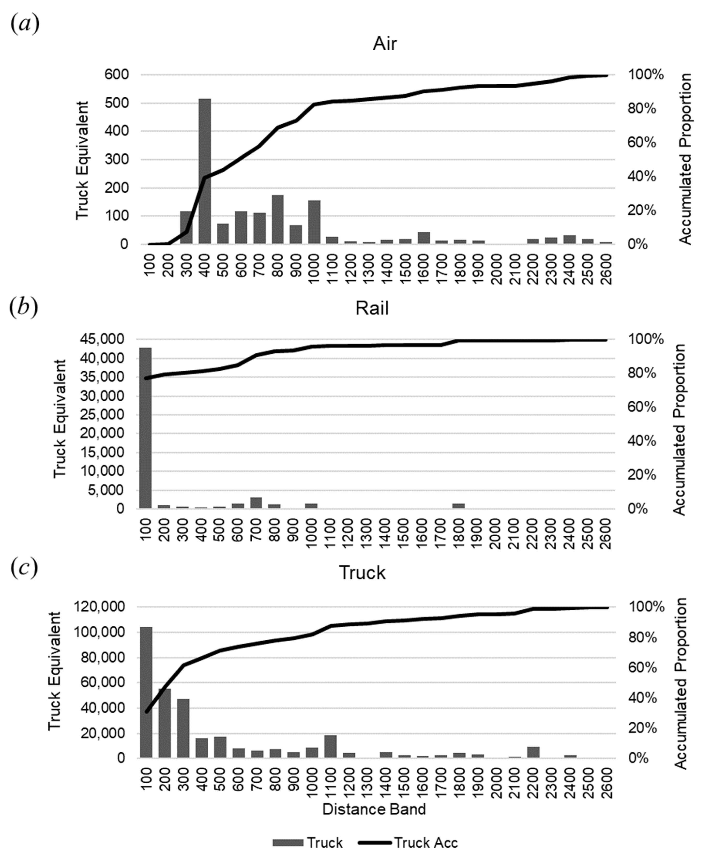
A typical North American semi-trailer truck (18-wheeler/big rig) carries 45,000 pounds (22.5 tons) of cargo, which puts the weight moved into perspective [53]. Figure 6 shows the distribution of truckload equivalents of pharmaceuticals moved within a consecutive 100-mile distance bands among the targeted MSAs. Air, rail, and truck accounted for 39.3%, 81.1%, and 66.2% of pharmaceutical truckload equivalent moved within 400 miles among the targeted MSAs. Altogether, cargo drones with a robust range of 400 miles can transport 68.2% of the pharmaceutical truckload equivalent moved by all modes among the target MSAs. Therefore, cargo drones can move 41.6% × 68.2% = 28.4% of all of the pharmaceutical truckload equivalent that was moved in the CONUS within 400 miles. The charts also suggest that the largest opportunities for displacing truck and rail movements is within the first 100 miles, which is well within the capacity limits of the first wave of heavy-lift cargo drone technologies underway [54]. The National Freight Strategic Plan estimates that without any mode shift, truck transport will increase 35% by 2040 [55]. Therefore, the potential impact cargo drones can have in removing truck traffic from congested roadways will only increase over time.
4.3. Limitations
The FAF dataset does not include all categories of medical cargo that moves through the middle mile. Furthermore, the data are based on estimates from a 2017 survey of one in seven freight-heavy U.S. businesses [48]. The FAF covered approximately two-thirds of all freight movements in the manufacturing and wholesale sectors [56]. Hence, the number of truckload equivalents moved underestimated the future likelihood. However, the proportion of rail and truck movements that drones can potentially displace may still be representative of the future reality.
Focusing on the case study on pharmaceuticals provided only a sampling of the potential impact that medical cargo drones could have on removing truck and rail traffic. Pharmaceuticals are a small subset of medical items that include blood, surgical equipment, and human transplant organs. The freight-heavy businesses surveyed to build the FAF dataset do not necessarily become involved in niche applications, such as transporting medical items to areas that are difficult to access, disaster relief missions, or emergency response.
This study did not consider external benefits, such as the potential to reduce greenhouse gas emissions or the potential to improve healthcare or save lives by transporting medical items more quickly, safely, and securely. Future autonomous drone fleets have the potential to compete with trucks, but the demand must also exist in those locations for them to be impactful. As demand for express freight grows with e-commerce and worsens road congestion, autonomous drones can offer an alternative.
5. Conclusions
Drones are an emerging mode of transportation that will potentially disrupt cargo transportation and logistics as we know it. The literature review of this work provides a comprehensive visual overview of the Advanced Air Mobility (AAM) standardization initiative. There has been much discussion on how AAM will achieve “last-mile” deliveries, but research has paid less attention to the potential impact of heavy-lift cargo drones on middle-mile logistics. This research focused on a case study of the potential for shifting pharmaceutical movements from ground transport to air. The workflow developed to analyze the potential impact combined unsupervised machine learning, geospatial processing, and ranked distribution methods. The workflow operated on a comprehensive dataset of commodity flows in the United States. Whereas this study demonstrated the utility of the workflow in quantifying opportunities for drones to move pharmaceuticals between hubs, analysts can use the workflow to analyze opportunities for any other commodity category by simply changing the identification code in the commodity extraction procedure.
The main finding was that nine metropolitan statistical areas (MSAs) in four U.S. regions moved 41.6% of all pharmaceuticals by weight. Of those, cargo drones with a 400-mile range capability can move 68.2% of all pharmaceuticals by weight. Therefore, cargo drones can initially move 41.6% × 68.2% = 28.4% of the pharmaceutical weight moved in the contiguous United States with initial deployments in only four regions. The analysis also showed that drones offer the greatest opportunity to displace both truck and rail transport of pharmaceuticals within 100 miles. The medical industry, including supply chain managers, logistic providers, urban planners, and policymakers, can utilize this result to inform decision making about where to initially locate cargo drone services for the largest mode shift opportunities, and this can demonstrate the early benefits to society.
Practitioners can standardize the workflow to scale its applicability for any other region of the world that collects similar datasets. Future work will utilize the generalized data mining workflow to study the potential markets for moving other types of high-value commodities, such as instrumentation, replacement parts, and perishable items that are vulnerable to supply chain disruptions.
Funding
The U.S. Department of Transportation supported this work, grant number [Mountain Plains Consortium].
Institutional Review Board Statement
Not applicable.
Informed Consent Statement
Not applicable.
Data Availability Statement
The data presented in this study are openly available as cited.
Conflicts of Interest
The author declares no conflict of interest.
References
- ACI. Air Cargo Guide; Airports Council International (ACI) North America: Montreal, QC, Canada, 2019. [Google Scholar]
- Perera, S.; Dawande, M.; Janakiraman, G.; Mookerjee, V. Retail Deliveries by Drones: How Will Logistics Networks Change? Prod. Oper. Manag. 2020, 29, 2019–2034. [Google Scholar] [CrossRef]
- GAO. Transforming Aviation: Stakeholders Identified Issues to Address for ‘Advanced Air Mobility’; Government Accountability Office (GAO): Washington, DC, USA, 2022. [Google Scholar]
- Lineberger, R.; Silver, D.; Hussain, A. Advanced Air Mobility: Can the United States Afford to Lose the Race; Deloitte Development LLC: London, UK, 2021. [Google Scholar]
- Sahoo, S.; Zhao, X.; Kyprianidis, K. A Review of Concepts, Benefits, and Challenges for Future Electrical Propulsion-Based Aircraft. Aerospace 2020, 7, 44. [Google Scholar] [CrossRef] [Green Version]
- Garg, S.; Aujla, G.S.; Erbad, A.; Rodrigues, J.J.P.C.; Chen, M.; Wang, X. Guest Editorial: Blockchain Envisioned Drones: Realizing 5G-Enabled Flying Automation. IEEE Netw. 2021, 35, 16–19. [Google Scholar] [CrossRef]
- Sharifi, F.; Meitiv, A.; Shelton, J.; Xu, X.; Burris, M.; Vallamsundar, S.; Xu, Y.A. Regional traffic operation and vehicle emission impact assessment of lane management policies. Res. Transp. Econ. 2021, 91, 101067. [Google Scholar] [CrossRef]
- Nisingizwe, M.P.; Ndishimye, P.; Swaibu, K.; Nshimiyimana, L.; Karame, P.; Dushimiyimana, V.; Musabyimana, J.P.; Musanabaganwa, C.; Nsanzimana, S.; Law, M.R. Effect of unmanned aerial vehicle (drone) delivery on blood product delivery time and wastage in Rwanda: A retrospective, cross-sectional study and time series analysis. Lancet Glob. Health 2022, 10, e564–e569. [Google Scholar] [CrossRef]
- Rejeb, A.; Rejeb, K.; Simske, S.J.; Treiblmaier, H. Drones for supply chain management and logistics: A review and research agenda. Int. J. Logist. Res. Appl. 2021, 26, 708–731. [Google Scholar] [CrossRef]
- Ayamga, M.; Akaba, S.; Nyaaba, A.A. Multifaceted applicability of drones: A review. Technol. Forecast. Soc. Chang. 2021, 167, 120677. [Google Scholar] [CrossRef]
- FAA. Urban Air Mobility: Concept of Operations, v1.0; Federal Aviation Administration (FAA): Washington, DC, USA, 2020. [Google Scholar]
- Uber Elevate. Fast-Forwarding to a Future of On-Demand Urban Air Transportation; Uber: Santa Cruz, CA, USA, 2016. [Google Scholar]
- Bridgelall, R.; Askarzadeh, T.; Tolliver, D.D. Introducing an efficiency index to evaluate eVTOL designs. Technol. Forecast. Soc. Chang. 2023, 191, 122539. [Google Scholar] [CrossRef]
- Jung, H.; Kim, J. Drone scheduling model for delivering small parcels to remote islands considering wind direction and speed. Comput. Ind. Eng. 2021, 163, 107784. [Google Scholar] [CrossRef]
- Ma, Y.; Zhang, W.; Zhang, Y.; Zhang, X.; Zhong, Y. Sizing Method and Sensitivity Analysis for Distributed Electric Propulsion Aircraft. J. Aircr. 2020, 57, 730–741. [Google Scholar] [CrossRef]
- Chung, S.H.; Sah, B.; Lee, J. Optimization for drone and drone-truck combined operations: A review of the state of the art and future directions. Comput. Oper. Res. 2020, 123, 105004. [Google Scholar] [CrossRef]
- Dong, C.; Akram, A.; Andersson, D.; Arnäs, P.-O.; Stefansson, G. The impact of emerging and disruptive technologies on freight transportation in the digital era: Current state and future trends. Int. J. Logist. Manag. 2021, 32, 386–412. [Google Scholar] [CrossRef]
- Banik, D.; Hossain, N.U.I.; Govindan, K.; Nur, F.; Babski-Reeves, K. A decision support model for selecting unmanned aerial vehicle for medical supplies: Context of COVID-19 pandemic. Int. J. Logist. Manag. 2022, 34, 473–496. [Google Scholar] [CrossRef]
- Thiels, C.A.; Aho, J.M.; Zietlow, S.P.; Jenkins, D.H. Use of Unmanned Aerial Vehicles for Medical Product Transport. Air Med. J. 2015, 34, 104–108. [Google Scholar] [CrossRef] [PubMed]
- Johnson, A.M.; Cunningham, C.J.; Arnold, E.; Rosamond, W.D.; Zègre-Hemsey, J.K. Impact of Using Drones in Emergency Medicine: What Does the Future Hold? Open Access Emerg. Med. 2021, 13, 487–498. [Google Scholar] [CrossRef]
- Laksham, K. Unmanned aerial vehicle (drones) in public health: A SWOT analysis. J. Fam. Med. Prim. Care 2019, 8, 342–346. [Google Scholar] [CrossRef] [PubMed]
- Beck, S.; Bui, T.T.; Davies, A.; Courtney, P.; Brown, A.; Geudens, J.; Royall, P.G. An evaluation of the drone delivery of adrenaline auto-injectors for anaphylaxis: Pharmacists’ perceptions, acceptance, and concerns. Drones 2020, 4, 66. [Google Scholar] [CrossRef]
- Scalea, J.R.; Pucciarella, T.; Talaie, T.; Restaino, S.; Drachenberg, C.B.; Alexander, C.; Al Qaoud, T.; Barth, R.N.; Wereley, N.M.; Scassero, M. Successful Implementation of Unmanned Aircraft Use for Delivery of a Human Organ for Transplantation. Ann. Surg. 2019, 274, e282–e288. [Google Scholar] [CrossRef]
- Shirane, T. A Systematic Review of Effectiveness of Automated External Defibrillators Delivered by Drones. Glob. J. Health Sci. 2020, 12, p101. [Google Scholar] [CrossRef]
- Mermiri, M.I.; Mavrovounis, G.A.; Pantazopoulos, I.N. Drones for Automated External Defibrillator Delivery: Where Do We Stand? J. Emerg. Med. 2020, 59, 660–667. [Google Scholar] [CrossRef] [PubMed]
- Baumgarten, M.C.; Röper, J.; Hahnenkamp, K.; Thies, K.-C. Drones delivering automated external defibrillators—Integrating unmanned aerial systems into the chain of survival: A simulation study in rural Germany. Resuscitation 2021, 172, 139–145. [Google Scholar] [CrossRef]
- Cheskes, S.; McLeod, S.L.; Nolan, M.; Snobelen, P.; Vaillancourt, C.; Brooks, S.C.; Dainty, K.N.; Chan, T.C.Y.; Drennan, I.R. Improving Access to Automated External Defibrillators in Rural and Remote Settings: A Drone Delivery Feasibility Study. J. Am. Heart Assoc. 2020, 9, e016687. [Google Scholar] [CrossRef]
- Pulver, A.; Wei, R. Optimizing the spatial location of medical drones. Appl. Geogr. 2018, 90, 9–16. [Google Scholar] [CrossRef]
- Claesson, A.; Fredman, D.; Svensson, L.; Ringh, M.; Hollenberg, J.; Nordberg, P.; Rosenqvist, M.; Djarv, T.; Österberg, S.; Lennartsson, J.; et al. Unmanned aerial vehicles (drones) in out-of-hospital-cardiac-arrest. Scand. J. Trauma Resusc. Emerg. Med. 2016, 24, 1–9. [Google Scholar] [CrossRef] [Green Version]
- Sedig, K.; Seaton, M.; Drennan, I.; Cheskes, S.; Dainty, K. “Drones are a great idea! What is an AED?” novel insights from a qualitative study on public perception of using drones to deliver automatic external defibrillators. Resusc. Plus 2020, 4, 100033. [Google Scholar] [CrossRef]
- Truog, S.; Maxim, L.; Matemba, C.; Blauvelt, C.; Ngwira, H.; Makaya, A.; Moreira, S.; Lawrence, E.; Ailstock, G.; Weitz, A.; et al. Insights before Flights: How Community Perceptions Can Make or Break Medical Drone Deliveries. Drones 2020, 4, 51. [Google Scholar] [CrossRef]
- Hiebert, B.; Nouvet, E.; Jeyabalan, V.; Donelle, L. The Application of Drones in Healthcare and Health-Related Services in North America: A Scoping Review. Drones 2020, 4, 30. [Google Scholar] [CrossRef]
- O’keeffe, D.T.; Johnson, K.; Maraka, S. OR30-04 Autonomous Drone Delivery of Insulin. J. Endocr. Soc. 2020, 4 (Suppl. S1), OR30-04. [Google Scholar] [CrossRef]
- Hii, M.S.Y.; Courtney, P.; Royall, P.G. An Evaluation of the Delivery of Medicines Using Drones. Drones 2019, 3, 52. [Google Scholar] [CrossRef] [Green Version]
- Euchi, J. Do drones have a realistic place in a pandemic fight for delivering medical supplies in healthcare systems problems? Chin. J. Aeronaut. 2020, 34, 182–190. [Google Scholar] [CrossRef]
- Saeed, F.; Mehmood, A.; Majeed, M.F.; Maple, C.; Saeed, K.; Khattak, M.K.; Wang, H.; Epiphaniou, G. Smart delivery and retrieval of swab collection kit for COVID-19 test using autonomous Unmanned Aerial Vehicles. Phys. Commun. 2021, 48, 101373. [Google Scholar] [CrossRef]
- Pirabán, A.; Guerrero, W.J.; Labadie, N. Survey on blood supply chain management: Models and methods. Comput. Oper. Res. 2019, 112, 104756. [Google Scholar] [CrossRef]
- Zailani, M.A.H.; Sabudin, R.Z.A.R.; Rahman, R.A.; Saiboon, I.M.; Ismail, A.; Mahdy, Z.A. Drone for medical products transportation in maternal healthcare: A systematic review and framework for future research. Medicine 2020, 99, e21967. [Google Scholar] [CrossRef]
- Poljak, M.; Šterbenc, A. Use of drones in clinical microbiology and infectious diseases: Current status, challenges and barriers. Clin. Microbiol. Infect. 2020, 26, 409–410. [Google Scholar] [CrossRef]
- Dhote, J.; Limbourg, S. Designing unmanned aerial vehicle networks for biological material transportation—The case of Brussels. Comput. Ind. Eng. 2020, 148, 106652. [Google Scholar] [CrossRef]
- Ghelichi, Z.; Gentili, M.; Mirchandani, P.B. Logistics for a fleet of drones for medical item delivery: A case study for Louisville, KY. Comput. Oper. Res. 2021, 135, 105443. [Google Scholar] [CrossRef]
- Jackson, A.; Srinivas, S.A. Simulation-Based Evaluation of Drone Integrated Delivery Strategies for Improving Pharmaceutical Service. In Supply Chain Management in Manufacturing and Service Systems; International Series in Operations Research & Management Science; Srinivas, S., Rajendran, S., Ziegler, H., Eds.; Springer: Cham, Switzerland, 2021; Volume 304, pp. 185–204. [Google Scholar]
- Amicone, D.; Cannas, A.; Marci, A.; Tortora, G. A Smart Capsule Equipped with Artificial Intelligence for Autonomous Delivery of Medical Material through Drones. Appl. Sci. 2021, 11, 7976. [Google Scholar] [CrossRef]
- Li, J.; Goh, W.W.; Jhanjhi, N.Z. A design of IoT-based medicine case for the multi-user medication management using drone in elderly centre. J. Eng. Sci. Technol. 2021, 16, 1145–1166. [Google Scholar]
- Lin, C.A.; Shah, K.; Mauntel, L.C.C.; Shah, S.A. Drone delivery of medications: Review of the landscape and legal considerations. Am. J. Health Pharm. 2018, 75, 153–158. [Google Scholar] [CrossRef] [PubMed]
- Graf, L.; Anner, F. Autonomous Vehicles as the Ultimate Efficiency Driver in Logistics. In Disrupting Logistics: Startups, Technologies, and Investors Building Future Supply Chains; Springer: Cham, Switzerland, 2021; pp. 191–206. [Google Scholar] [CrossRef]
- Sanders, N.R.; Ganeshan, R. Big data in supply chain management. Prod. Oper. Manag. 2018, 27, 1745–1748. [Google Scholar] [CrossRef]
- FHWA. Freight Analysis Framework Verion 5 (FAF5). 22 November 2021. Available online: https://faf.ornl.gov/faf5/Default.aspx (accessed on 13 February 2022).
- USCB. TIGER/Line Geodatabases. United States Census Bureau (USCB). 16 December 2021. Available online: https://www2.census.gov/geo/tiger/TIGER2021/COUNTY/ (accessed on 22 April 2022).
- USCB. Commodity Flow Survey Geographies. United States Census Bureau (USCB). 8 October 2021. Available online: https://www.census.gov/programs-surveys/cfs/technical-documentation/geographies.html (accessed on 28 April 2022).
- McDowell, E.; Pepper, M.; Munoz Aneiros, A. Towards a theory of self-organizing supply chain clusters. Syst. Res. Behav. Sci. 2022, 40, 88–100. [Google Scholar] [CrossRef]
- Aggarwal, C.C. Data Mining; Springer International Publishing: New York, NY, USA, 2015; p. 734. [Google Scholar]
- FreightWaves. How Much Weight Can a Big Rig Carry? FreightWaves. 1 January 2020. Available online: https://www.freightwaves.com/news/how-much-weight-can-a-big-rig-carry (accessed on 17 April 2022).
- Schwab, A.; Thomas, A.; Bennett, J.; Robertson, E.; Cary, S. Electrification of Aircraft: Challenges, Barriers, and Potential Impacts; National Renewable Energy Laboratory (NREL): Golden, CO, USA, 2021. [Google Scholar]
- USDOT. National Freight Strategic Plan; United States Department of Transportation (USDOT): Washington, DC, USA, 2020. [Google Scholar]
- FDOT. SWOT Analysis of TRANSEARCH and FAF Data; Florida Department of Transportation (FDOT): Washington, DC, USA, 2016. [Google Scholar]
Figure 1.
Empirical classification of key factors in the adoption of AAM.

Figure 2.
The hybrid analytical workflow.
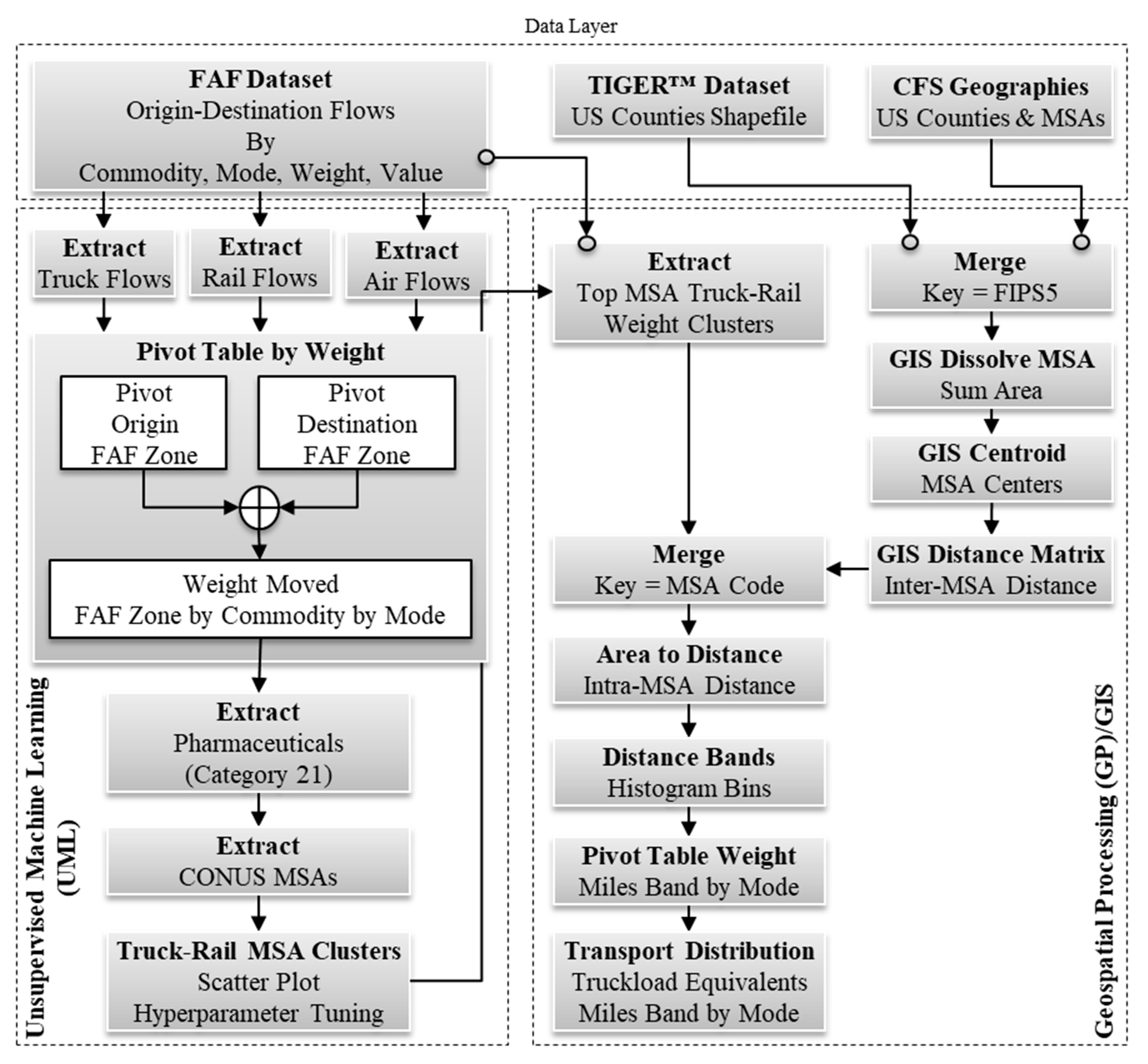
Figure 3.
MSAs, remaining FAF Zones, and their centroids.
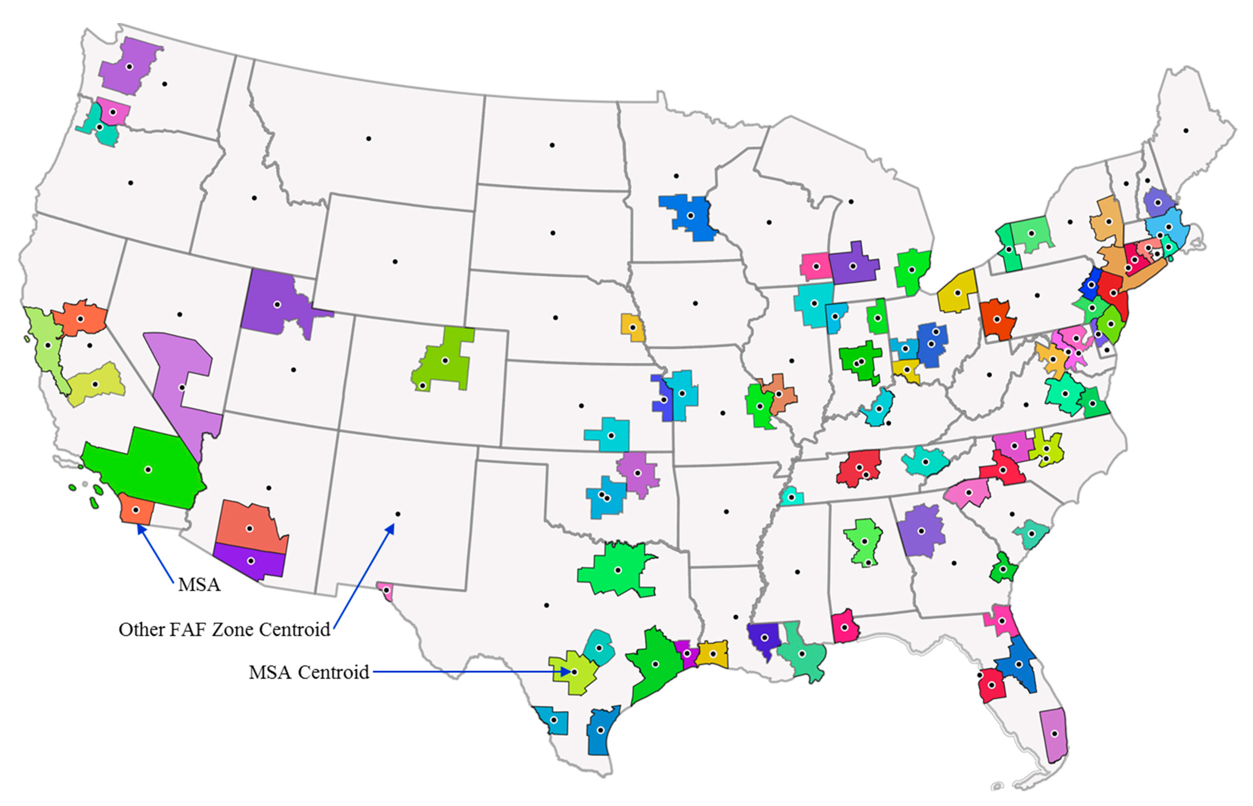
Figure 4.
Outlier MSA identification by (a) DBSCAN, (b) Louvain, and (c) k-means clustering methods.
Figure 4.
Outlier MSA identification by (a) DBSCAN, (b) Louvain, and (c) k-means clustering methods.

Figure 5.
The top nine MSAs among those moving more than 90% of the weight of pharmaceuticals by air, truck, and rail.
Figure 5.
The top nine MSAs among those moving more than 90% of the weight of pharmaceuticals by air, truck, and rail.
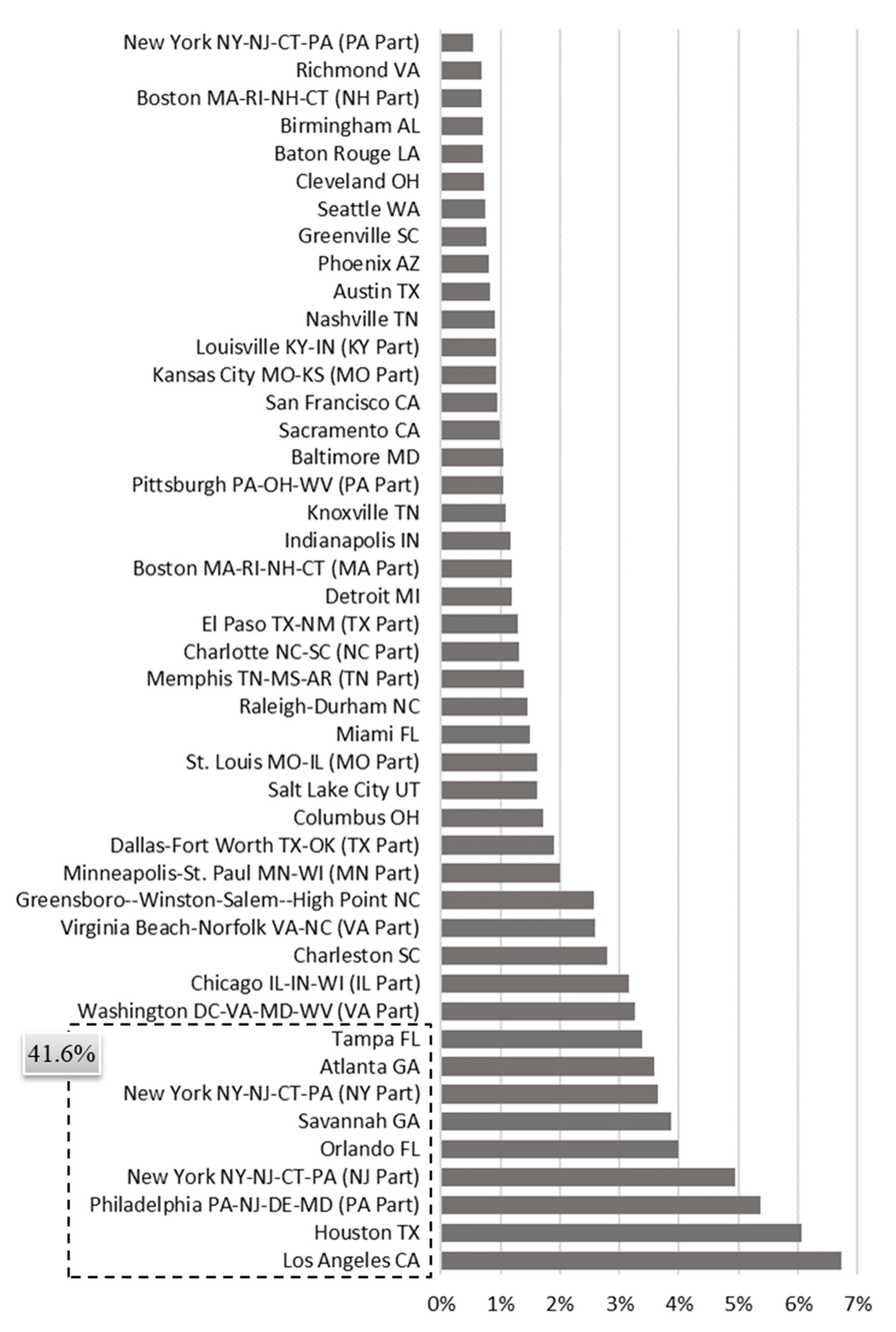
Figure 6.
Distance band distribution for the top nine MSAs moving pharmaceuticals by (a) air, (b) rail, and (c) truck.
Figure 6.
Distance band distribution for the top nine MSAs moving pharmaceuticals by (a) air, (b) rail, and (c) truck.

Table 1.
Unsupervised machine learning algorithms compared for cluster detection.
| Algorithm | Theory of Operations | Hyperparameters |
|---|---|---|
| DBSCAN | Density-based spatial clustering of applications with noise (DBSCAN). Separates densely packed points from outliers. Initializes core points as those that are within distance d of k points. Grows a cluster by randomly labeling a core point as a cluster, and then grows that cluster by sequentially adding other core points that are within distance d until it assigns all core points to a cluster. Finally, it assigns non-core points to clusters that are within distance d. It labels the unassigned points as outliers. A: Finds clusters that linear hyperplanes cannot separate. D: Specification of d and k requires heuristics, which can be impractical for large feature spaces. | Normalize features: yes k: 4 d: 0.47 Distance: Euclidean |
| Louvain | Extracts communities from networks by constructing a k-nearest neighbor graph with edges weighted by the number of shared neighbors. The algorithm labeled clusters based on edge density inside communities relative to between communities. A: Algorithms and process large networks quickly. D: The resolution parameter adjusts the cluster size, which can make it difficult to cluster small communities. | Normalize features: no PCA preprocessing: 2 Distance: Euclidean Number of neighbors: 12 Resolution: 5.0 |
| k-means | Randomly selects one point per cluster, and then iteratively recalculates centroids while reassigning points to their nearest centroid. The algorithm converges once cluster reassignments stop, or the number of specified iterations is complete. A: Performs well when clusters are symmetrical. D: Specifying the number of clusters require heuristics. | Normalize features: no Number of clusters: 3 Initialization: k-means ++ Number of reruns: 10 Number of iterations: 300 |
Disclaimer/Publisher’s Note: The statements, opinions and data contained in all publications are solely those of the individual author(s) and contributor(s) and not of MDPI and/or the editor(s). MDPI and/or the editor(s) disclaim responsibility for any injury to people or property resulting from any ideas, methods, instructions or products referred to in the content. |
© 2023 by the author. Licensee MDPI, Basel, Switzerland. This article is an open access article distributed under the terms and conditions of the Creative Commons Attribution (CC BY) license (https://creativecommons.org/licenses/by/4.0/).
Share and Cite
MDPI and ACS Style
Bridgelall, R. Unlocking Drone Potential in the Pharma Supply Chain: A Hybrid Machine Learning and GIS Approach. Standards 2023, 3, 283-296. https://doi.org/10.3390/standards3030021
AMA Style
Bridgelall R. Unlocking Drone Potential in the Pharma Supply Chain: A Hybrid Machine Learning and GIS Approach. Standards. 2023; 3(3):283-296. https://doi.org/10.3390/standards3030021
Chicago/Turabian StyleBridgelall, Raj. 2023. "Unlocking Drone Potential in the Pharma Supply Chain: A Hybrid Machine Learning and GIS Approach" Standards 3, no. 3: 283-296. https://doi.org/10.3390/standards3030021