Monitoring and Cordoning Wildfires with an Autonomous Swarm of Unmanned Aerial Vehicles
Abstract
1. Introduction
1.1. Wildfires, a Major Global Environmental Issue
1.2. Monitoring Large Forests in Remote Areas Using Modern Sensing Technologies
1.3. Using Unmanned and Autonomous (Aerial) Sensing Platforms for Remote Fire Monitoring
1.4. Scope
1.5. Contribution of This Article
- Detection: the first mission of autonomous devices in the vicinity of a fire event is to pinpoint its location in a possibly much larger area— this is a partially cooperative activity (division of labour to minimise cover times [50]).
- Evasion: when in close proximity to the fire, an autonomous device must be able to keep itself out of harm’s way, usually by maintaining a safe distance (which may vary depending on environmental conditions and position relative to the blaze)— primarily an individual activity.
- Encirclement: whether it’s to guide the fire crews or implement their own containment strategy, autonomous devices must be able to form a (dynamic) perimeter around the wildfire— necessarily a cooperative activity.
2. Modelling
2.1. The Wildfire Model
2.1.1. Motivating the Scope of the Model
“Fire spread is a dynamic process, which depends on environmental variables, such as wind speed, moisture content, fuel type and density, ground slope, etc. Developing an accurate fire spread model that can predict fire size and shape over time is an ongoing research challenge”[20]. (2021)
2.1.2. Environment Topology, Fuel and the Depletion of Fuel Due to Fire
2.1.3. Fire Propagation through the Environment
2.1.4. Heat Propagation through the Environment
2.2. The Drone Model
2.2.1. Motivating the Scope of the Model
2.2.2. The Impact of Heat Sources in the Environment on the Drone
2.2.3. The Drone Perception Model
2.2.4. The Drone Communication Model
3. Controlling the Swarm
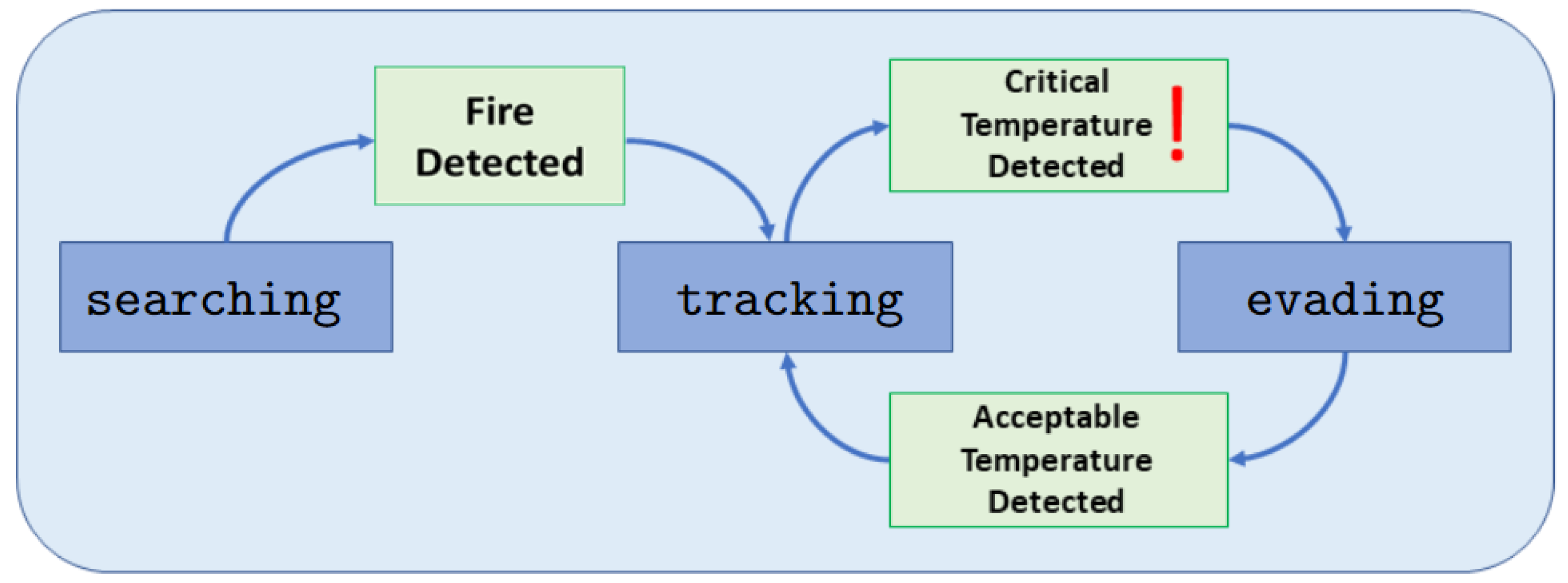
3.1. Different Behaviours of a Drone
3.1.1. Behaviour 1: Searching
3.1.2. Behaviour 2: Tracking
3.1.3. Behaviour 3: Evading
3.2. Triggers to Transition between Behaviours
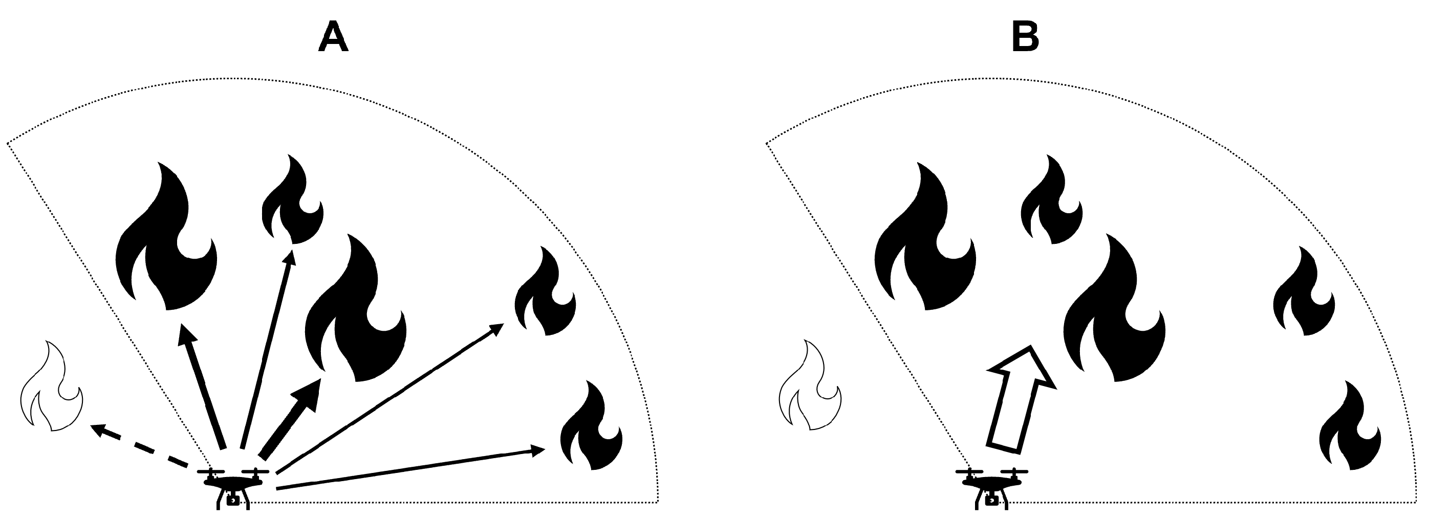
- the UAV has detected a heat source. This occurs when the magnitude of the resultant vector (see Section 2.2.3) exceeds a predefined threshold; cf. Figure 5.
- One of the two nearest neighbours of the UAV has detected a heat source, which starts the recruitment process. NB: a recruited drone that has not itself detected a heat source does not initiate recruitment. This is designed to prevent the whole swarm being recruited by cascade when the first unit detects the first fire; cf. Figure 5.
3.3. Encircling the Fire
- The target neighbour is not the original sender: no forwarding occurs, and the token is simply dropped
- The target neighbour is the original sender, in which case there is the possibility that a continuous and symmetrical loop (cordon) has been formed and the token is forwarded to its initiator.
4. Numerical Experiment Setup and Data Collection
4.1. Simulation Setup
4.1.1. The Environment
4.1.2. The Fire Source
4.1.3. The Fire Propagation
4.1.4. The Movement of the Drones
4.1.5. The Termination Criteria
4.2. Data Collection
4.2.1. Performance Metric
4.2.2. Recorded Data
5. Results of Numerical Experiments
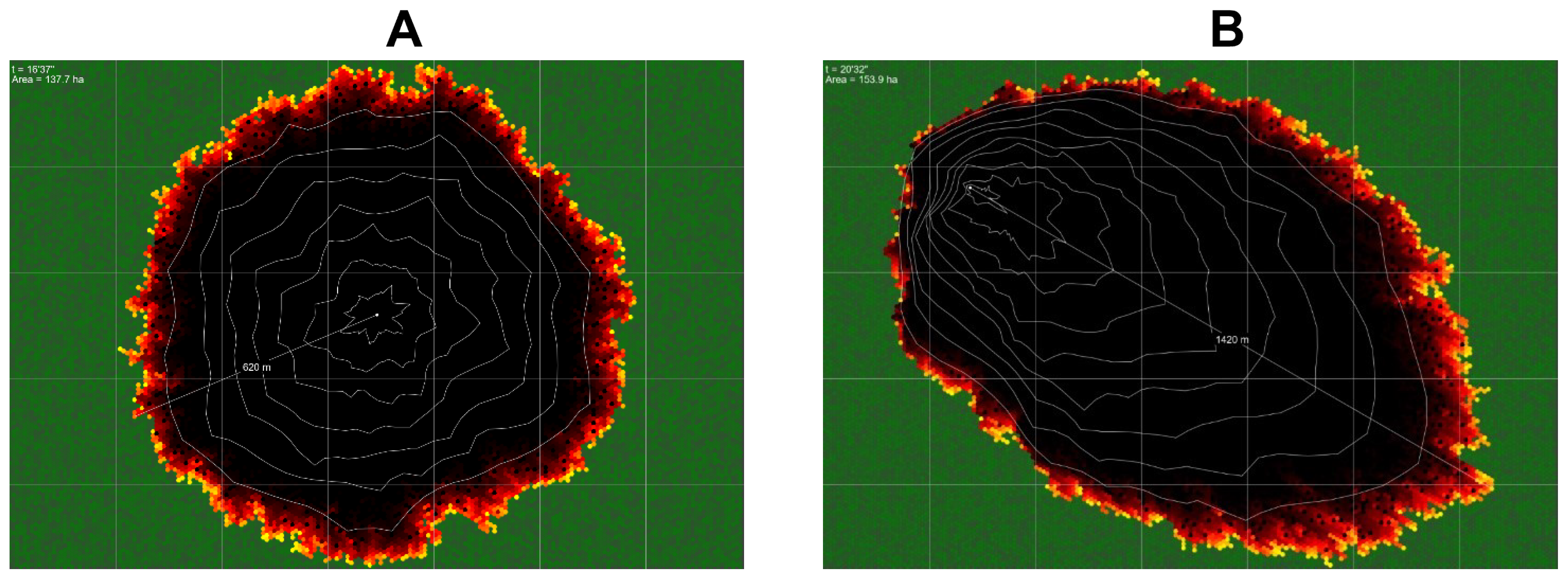
5.1. The Impact of Wind on the Wildfire Model
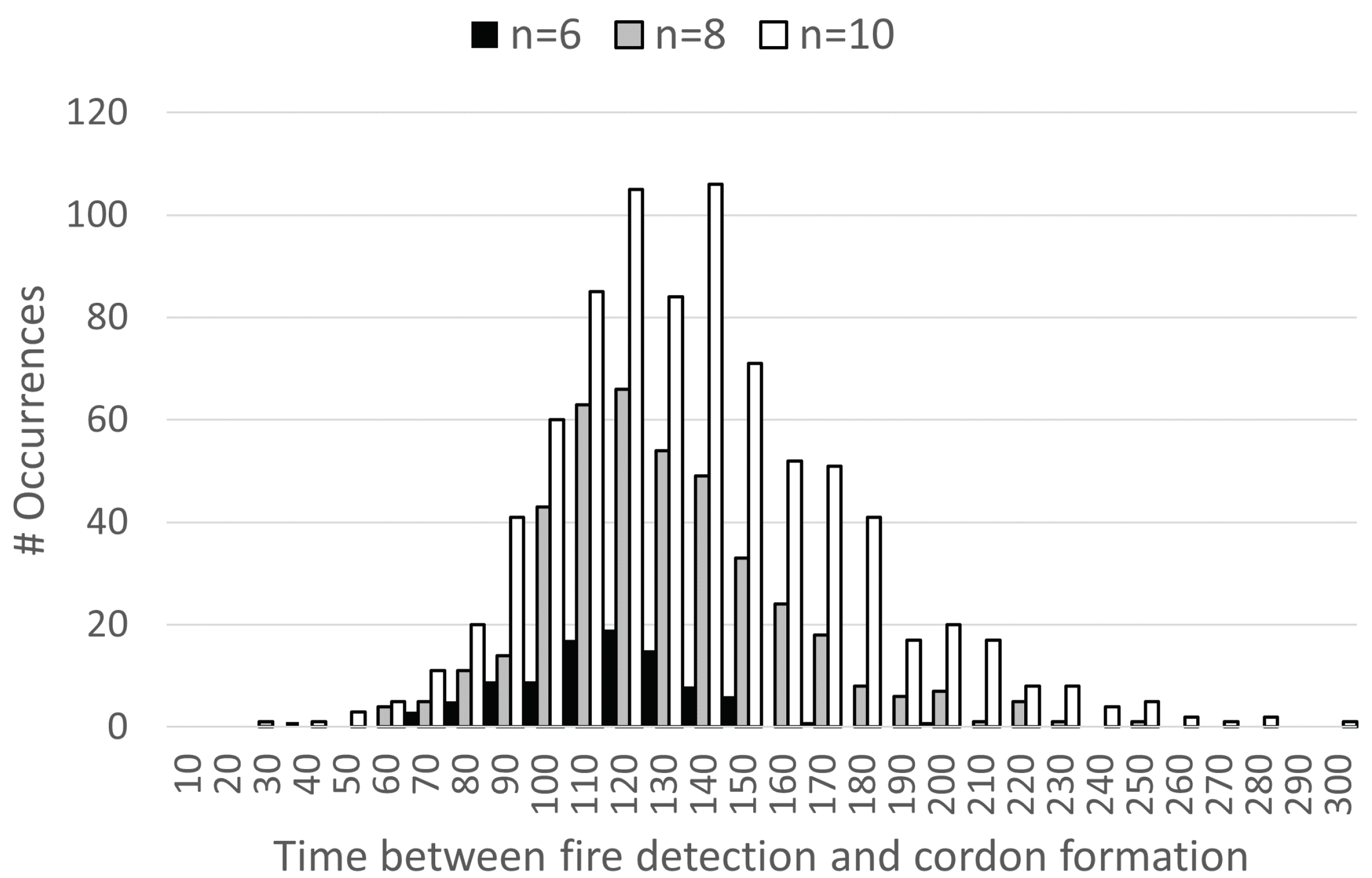
5.2. The Impact of Swarm Size on Success
5.3. The Impact of Damaged Area on the Drones’ Ability to Contain the Fire
5.4. The Correlation between Swarm Size and Area to Be searched
- it has a direct impact on feasibility, and
- it may inform the choice of how many drones to deploy, given the circumstances.
6. Discussion, Conclusions and Future Work
Author Contributions
Funding
Institutional Review Board Statement
Informed Consent Statement
Data Availability Statement
Acknowledgments
Conflicts of Interest
References
- Alizadeh, M.R.; Abatzoglou, J.T.; Luce, C.H.; Adamowski, J.F.; Farid, A.; Sadegh, M. Warming enabled upslope advance in western US forest fires. Proc. Natl. Acad. Sci. USA 2021, 118, e2009717118. [Google Scholar] [CrossRef] [PubMed]
- Zhuang, Y.; Fu, R.; Santer, B.D.; Dickinson, R.E.; Hall, A. Quantifying contributions of natural variability and anthropogenic forcings on increased fire weather risk over the western United States. Proc. Natl. Acad. Sci. USA 2021, 118, e2111875118. [Google Scholar] [CrossRef] [PubMed]
- Williams, A.P.; Livneh, B.; McKinnon, K.A.; Hansen, W.D.; Mankin, J.S.; Cook, B.I.; Smerdon, J.E.; Varuolo-Clarke, A.M.; Bjarke, N.R.; Juang, C.S.; et al. Growing impact of wildfire on western US water supply. Proc. Natl. Acad. Sci. USA 2022, 119, e2114069119. [Google Scholar] [CrossRef] [PubMed]
- Ifimov, G.; Naprstek, T.; Johnston, J.M.; Arroyo-Mora, J.P.; Leblanc, G.; Lee, M.D. Geocorrection of Airborne Mid-Wave Infrared Imagery for Mapping Wildfires without GPS or IMU. Sensors 2021, 21, 3047. [Google Scholar] [CrossRef]
- Toan, N.T.; Thanh Cong, P.; Viet Hung, N.Q.; Jo, J. A deep learning approach for early wildfire detection from hyperspectral satellite images. In Proceedings of the 2019 7th International Conference on Robot Intelligence Technology and Applications (RiTA), Daejeon, Korea, 1–3 November 2019; pp. 38–45. [Google Scholar] [CrossRef]
- Carnicer, J.; Alegria, A.; Giannakopoulos, C.; Di Giuseppe, F.; Karali, A.; Koutsias, N.; Lionello, P.; Parrington, M.; Vitolo, C. Global warming is shifting the relationships between fire weather and realized fire-induced CO2 emissions in Europe. Sci. Rep. 2022, 12, 10365. [Google Scholar] [CrossRef] [PubMed]
- Shouse, B.; Forest Fires Kick Up Greenhouse Gas: Human Activities Led to Massive Fire, Carbon Dioxide Release in 1997. Science (News, Environment). 2002. Available online: https://www.science.org/content/article/forest-fires-kick-greenhouse-gas (accessed on 1 October 2022).
- Halofsky, J.E.; Peterson, D.L.; Harvey, B.J. Changing wildfire, changing forests: The effects of climate change on fire regimes and vegetation in the Pacific Northwest, USA. Fire Ecol. 2020, 16, 4. [Google Scholar] [CrossRef]
- Alkhatib, A.A.A. A Review on Forest Fire Detection Techniques. Int. J. Distrib. Sens. Networks 2014, 10, 597368. [Google Scholar] [CrossRef]
- Dampage, U.; Bandaranayake, L.; Wanasinghe, R.; Kottahachchi, K.; Jayasanka, B. Forest fire detection system using wireless sensor networks and machine learning. Sci. Rep. 2022, 12, 46. [Google Scholar] [CrossRef] [PubMed]
- Qian, J.; Lin, H. A Forest Fire Identification System Based on Weighted Fusion Algorithm. Forests 2022, 13, 1301. [Google Scholar] [CrossRef]
- Xue, Z.; Lin, H.; Wang, F. A Small Target Forest Fire Detection Model Based on YOLOv5 Improvement. Forests 2022, 13, 1332. [Google Scholar] [CrossRef]
- Dimitropoulos, S. Fighting fire with science. Nature 2019, 576, 328–329. [Google Scholar] [CrossRef] [PubMed]
- Ghali, R.; Akhloufi, M.A.; Jmal, M.; Souidene Mseddi, W.; Attia, R. Wildfire Segmentation Using Deep Vision Transformers. Remote Sens. 2021, 13, 3527. [Google Scholar] [CrossRef]
- Kelhä, V.; Herland, E.A.; Lohi, A. Satellite Based Forest Fire Detection and Automatic Alert System—Pilot Experiment. In Early Warning Systems for Natural Disaster Reduction; Zschau, J., Küppers, A., Eds.; Springer: Berlin/Heidelberg, Germany, 2003; pp. 649–653. [Google Scholar] [CrossRef]
- Karlikowski, T. Forest Fire Prevention and Control. In Proceedings of an International Seminar organized by the Timber Committee of the United Nations Economic Commission for Europe, Warsaw, Poland, 20–22 May 1981; van Nao, T., Ed.; Springer: Dordrecht, Netherlands, 1982; pp. 85–91. [Google Scholar] [CrossRef]
- Thapa, S.; Chitale, V.S.; Pradhan, S.; Shakya, B.; Sharma, S.; Regmi, S.; Bajracharya, S.; Adhikari, S.; Dangol, G.S. Forest Fire Detection and Monitoring. In Earth Observation Science and Applications for Risk Reduction and Enhanced Resilience in Hindu Kush Himalaya Region: A Decade of Experience from SERVIR; Bajracharya, B., Thapa, R.B., Matin, M.A., Eds.; Springer International Publishing: Cham, Switzerland, 2021; pp. 147–167. [Google Scholar] [CrossRef]
- Thomas, P.J.; Hersom, C.; Al Kenany, S.; Staley, D. Wildfire Detection with a Microsatellite. In Applications of Photonic Technology 2: Communications, Sensing, Materials, and Signal Processing; Lampropoulos, G.A., Lessard, R.A., Eds.; Springer US: Boston, MA, USA, 1997; pp. 633–640. [Google Scholar] [CrossRef]
- Moran, C.J.; Hoff, V.; Parsons, R.A.; Queen, L.P.; Seielstad, C.A. Mapping Fine-Scale Crown Scorch in 3D with Remotely Piloted Aircraft Systems. Fire 2022, 5, 59. [Google Scholar] [CrossRef]
- Bushnaq, O.M.; Chaaban, A.; Al-Naffouri, T.Y. The Role of UAV-IoT Networks in Future Wildfire Detection. IEEE Internet Things J. 2021, 8, 16984–16999. [Google Scholar] [CrossRef]
- Yuan, C.; Liu, Z.; Zhang, Y. Aerial Images-Based Forest Fire Detection for Firefighting Using Optical Remote Sensing Techniques and Unmanned Aerial Vehicles. J. Intell. Robot. Syst. 2017, 88, 635–654. [Google Scholar] [CrossRef]
- Kumar, S.S.; Hult, J.; Picotte, J.; Peterson, B. Potential Underestimation of Satellite Fire Radiative Power Retrievals over Gas Flares and Wildland Fires. Remote Sens. 2020, 12, 238. [Google Scholar] [CrossRef]
- Phua, M.H.; Tsuyuki, S. Assessing Impact of Multiple Fires on a Tropical Peat Swamp Forest Using High and Very High-Resolution Satellite Images. Fire 2021, 4, 89. [Google Scholar] [CrossRef]
- Allison, R.S.; Johnston, J.M.; Wooster, M.J. Sensors for Fire and Smoke Monitoring. Sensors 2021, 21, 5402. [Google Scholar] [CrossRef]
- Barmpoutis, P.; Papaioannou, P.; Dimitropoulos, K.; Grammalidis, N. A Review on Early Forest Fire Detection Systems Using Optical Remote Sensing. Sensors 2020, 20, 6442. [Google Scholar] [CrossRef] [PubMed]
- Dufour, D.; Le Noc, L.; Tremblay, B.; Tremblay, M.N.; Généreux, F.; Terroux, M.; Vachon, C.; Wheatley, M.J.; Johnston, J.M.; Wotton, M.; et al. A Bi-Spectral Microbolometer Sensor for Wildfire Measurement. Sensors 2021, 21, 3690. [Google Scholar] [CrossRef] [PubMed]
- Pang, Y.; Chen, S.; An, J.; Wang, K.; Deng, Y.; Benard, A.; Lajnef, N.; Cao, C. Multilayered Cylindrical Triboelectric Nanogenerator to Harvest Kinetic Energy of Tree Branches for Monitoring Environment Condition and Forest Fire. Adv. Funct. Mater. 2020, 30, 2003598. [Google Scholar] [CrossRef]
- Evans, W.G. Perception of Infrared Radiation from Forest Fires by Melanophila Acuminata de Geer (Buprestidae, Coleoptera). Ecology 1966, 47, 1061–1065. [Google Scholar] [CrossRef]
- Schmitz, H.; Norkus, V.; Hess, N.; Bousack, H. The Infrared Sensilla in the Beetle Melanophila acuminata as model for new infrared sensors. Proc. SPIE-Int. Soc. Opt. Eng. 2009, 98, 738–746. [Google Scholar] [CrossRef]
- Saffre, F.; Hildmann, H.; Karvonen, H.; Lind, T. Remote Sensing/Photogrammetry, Self-Swarming for Multi-Robot Systems (MRS) Deployed for Situational Awareness (SA). In Drones: New Developments and Environmental Applications.; Lipping, T., Linna, P., Narra, N., Eds.; Springer International Publishing: Cham, Switzerland, 2022; pp. 51–72. ISBN 978-3-030-77860-6. [Google Scholar]
- Ivanova, S.; Prosekov, A.; Kaledin, A. A Survey on Monitoring of Wild Animals during Fires Using Drones. Fire 2022, 5, 60. [Google Scholar] [CrossRef]
- Roldán-Gómez, J.J.; González-Gironda, E.; Barrientos, A. A Survey on Robotic Technologies for Forest Firefighting: Applying Drone Swarms to Improve Firefighters’ Efficiency and Safety. Appl. Sci. 2021, 11, 363. [Google Scholar] [CrossRef]
- Ausonio, E.; Bagnerini, P.; Ghio, M. Drone Swarms in Fire Suppression Activities: A Conceptual Framework. Drones 2021, 5, 17. [Google Scholar] [CrossRef]
- Guede-Fernández, F.; Martins, L.; de Almeida, R.V.; Gamboa, H.; Vieira, P. A Deep Learning Based Object Identification System for Forest Fire Detection. Fire 2021, 4, 75. [Google Scholar] [CrossRef]
- Liao, Y.H.; Juang, J.G. Real-Time UAV Trash Monitoring System. Appl. Sci. 2022, 12, 1838. [Google Scholar] [CrossRef]
- Wahyono; Harjoko, A.; Dharmawan, A.; Adhinata, F.D.; Kosala, G.; Jo, K.H. Real-Time Forest Fire Detection Framework Based on Artificial Intelligence Using Color Probability Model and Motion Feature Analysis. Fire 2022, 5, 23. [Google Scholar] [CrossRef]
- Hildmann, H.; Kovacs, E.; Saffre, F.; Isakovic, A.F. Nature-Inspired Drone Swarming for Real-Time Aerial Data-Collection Under Dynamic Operational Constraints. Drones 2019, 3, 71. [Google Scholar] [CrossRef]
- Moadab, A.; Farajzadeh, F.; Fatahi Valilai, O. Drone routing problem model for last-mile delivery using the public transportation capacity as moving charging stations. Sci. Rep. 2022, 12, 6361. [Google Scholar] [CrossRef] [PubMed]
- Ropero, F.; Muñoz, P.; R-Moreno, M.D.; Hildmann, H. A cooperative UGV-AUV path planning algorithm in R3-space for planetary exploration. In Proceedings of the 16th Symposium on Advanced Space Technologies in Robotics and Automation (ASTRA); ESA, European Space Agency: Noordwijk, The Netherlands, 1–2 June 2022. [Google Scholar]
- Ropero, F. Algorithms for the multi-robot systems on the cooperative exploration and last mile delivery problems. Ph.D. Thesis, Universidad de Alcala, Madrid, Spain, 2020. [Google Scholar]
- Lahmeri, M.A.; Kishk, M.A.; Alouini, M.S. Charging Techniques for UAV-Assisted Data Collection: Is Laser Power Beaming the Answer? IEEE Commun. Mag. 2022, 60, 50–56. [Google Scholar] [CrossRef]
- Boychuk, D.; Braun, W.J.; Kulperger, R.J.; Krougly, Z.L.; Stanford, D.A. A stochastic forest fire growth model. Environ. Ecol. Stat. 2009, 16, 133–151. [Google Scholar] [CrossRef]
- Cruz, M.G.; Alexander, M.E. Uncertainty associated with model predictions of surface and crown fire rates of spread. Environ. Model. Softw. 2013, 47, 16–28. [Google Scholar] [CrossRef]
- Mell, W.; Jenkins, M.A.; Gould, J.; Cheney, P. A physics-based approach to modelling grassland fires. Int. J. Wildland Fire 2007, 16, 1–22. [Google Scholar] [CrossRef]
- Rossi, J.L.; Chetehouna, K.; Collin, A.; Moretti, B.; Balbi, J.H. Simplified flame models and prediction of the thermal radiation emitted by a flame front in an outdoor fire. Combust. Sci. Technol. 2010, 182, 1457–1477. [Google Scholar] [CrossRef]
- Tymstra, C. Development and Structure of Prometheus: The Canadian Wildland Fire Growth Simulation Model; Northern Forestry Centre: Edmonton, AB, Canada, 2010. [Google Scholar]
- Pan, H.; Badawi, D.; Cetin, A.E. Computationally Efficient Wildfire Detection Method Using a Deep Convolutional Network Pruned via Fourier Analysis. Sensors 2020, 20, 2891. [Google Scholar] [CrossRef]
- Wang, K.; Yuan, Y.; Chen, M.; Lou, Z.; Zhu, Z.; Li, R. A Study of Fire Drone Extinguishing System in High-Rise Buildings. Fire 2022, 5, 75. [Google Scholar] [CrossRef]
- Laarni, J.; Väätänen, A.; Karvonen, H.; Lastusilta, T.; Saffre, F. Development of a Concept of Operations for a Counter-Swarm Scenario. In Proceedings of the Engineering Psychology and Cognitive Ergonomics - 19th International Conference, EPCE 2022, Held as Part of the 24th HCI International Conference, HCII 2022; Lecture Notes in Computer Science; Harris, D., Li, W.C., Eds.; Springer: Berlin/Heidelberg, Germany, June–July; 2022; pp. 49–63. [Google Scholar] [CrossRef]
- Chupeau, M.; Bénichou, O.; Voituriez, R. Cover times of random searches. Nat. Phys. 2015, 11, 844–847. [Google Scholar] [CrossRef]
- Rios, O.; Valero, M.M.; Pastor, E.; Planas, E. A Data-Driven Fire Spread Simulator: Validation in Vall-llobrega’s Fire. Front. Mech. Eng. 2019, 5, 8. [Google Scholar] [CrossRef]
- Rim, C.B.; Om, K.C.; Ren, G.; Kim, S.S.; Kim, H.C.; Kang-Chol, O. Establishment of a wildfire forecasting system based on coupled weather–Wildfire modeling. Appl. Geogr. 2018, 90, 224–228. [Google Scholar] [CrossRef]
- Coen, J.; Cruz, M.; Rosales-Giron, D.; Speer, K. Coupled Fire–Atmosphere Model Evaluation and Challenges. In Wildland Fire Dynamics; Speer, K., Goodrick, S., Eds.; Cambridge University Press: Cambridge, UK, 2022; pp. 209–249. [Google Scholar] [CrossRef]
- Koo, E.; Pagni, P.; Stephens, S.; Huff, J.; Woycheese, J.; Weise, D. A Simple Physical Model For Forest Fire Spread Rate. Fire Saf. Sci. 2005, 8, 851–862. [Google Scholar] [CrossRef]
- Wu, Z.; Wang, B.; Li, M.; Tian, Y.; Quan, Y.; Liu, J. Simulation of forest fire spread based on artificial intelligence. Ecol. Indic. 2022, 136, 108653. [Google Scholar] [CrossRef]
- Anderson, H.; Forest, I.; Range Experiment Station (Ogden, U. Aids to Determining Fuel Models for Estimating Fire Behavior; General technical report INT, U.S. Department of Agriculture, Forest Service, Intermountain Forest and Range Experiment Station: Larue County, KY, USA, 1981. [Google Scholar]
- Frost, S.M.; Alexander, M.E.; Jenkins, M.J. The Application of Fire Behavior Modeling to Fuel Treatment Assessments at Army Garrison Camp Williams, Utah. Fire 2022, 5, 78. [Google Scholar] [CrossRef]
- Giuseppi, A.; Germanà, R.; Fiorini, F.; Delli Priscoli, F.; Pietrabissa, A. UAV Patrolling for Wildfire Monitoring by a Dynamic Voronoi Tessellation on Satellite Data. Drones 2021, 5, 130. [Google Scholar] [CrossRef]
- Alexandridis, A.; Vakalis, D.; Siettos, C.I.; Bafas, G.V. A cellular automata model for forest fire spread prediction: The case of the wildfire that swept through Spetses Island in 1990. Appl. Math. Comput. 2008, 204, 191–201. [Google Scholar] [CrossRef]
- Gharakhanlou, N.M.; Hooshangi, N. Dynamic simulation of fire propagation in forests and rangelands using a GIS-based cellular automata model. Int. J. Wildland Fire 2021, 30, 652–663. [Google Scholar] [CrossRef]
- Karafyllidis, I.; Thanailakis, A. A model for predicting forest fire spreading using cellular automata. Ecol. Model. 1997, 99, 87–97. [Google Scholar] [CrossRef]
- Beer, T. The interaction of wind and fire. Bound.-Layer Meteorol. 1991, 54, 287–308. [Google Scholar] [CrossRef]
- Dennison, P.E.; Charoensiri, K.; Roberts, D.A.; Peterson, S.H.; Green, R.O. Wildfire temperature and land cover modeling using hyperspectral data. Remote Sens. Environ. 2006, 100, 212–222. [Google Scholar] [CrossRef]
- Saffre, F.; Hildmann, H.; Karvonen, H. The Design Challenges of Drone Swarm Control. In Proceedings of the Engineering Psychology and Cognitive Ergonomics; Harris, D., Li, W.C., Eds.; Springer International Publishing: Cham, Switzerland, July 2021; pp. 408–426. [Google Scholar]
- Fang, T.; Bao, W.; Zhu, X.; Li, F.; Yuan, Y.; Ma, L.; Wang, J. Cooperative Encirclement in Swarm Robotics Based on Triangle Antenna Model. In Proceedings of the 2020 3rd International Conference on Robotics, Control and Automation Engineering (RCAE), Chongqing, China, 5–8 November 2020; pp. 17–24. [Google Scholar] [CrossRef]
- Munawar, H.S.; Gharineiat, Z.; Akram, J.; Imran Khan, S. A Framework for Burnt Area Mapping and Evacuation Problem Using Aerial Imagery Analysis. Fire 2022, 5, 122. [Google Scholar] [CrossRef]
- Hildmann, H.; Almeida, M.; Kovacs, E.; Saffre, F. Termite algorithms to control collaborative swarms of satellites. In Proceedings of the International Symposium on Artificial Intelligence, Robotics and Automation in Space (i-SAIRAS 2018); i-SAIRAS 2018, European Space Agency: Madrid, Spain, May 2018. [Google Scholar]
- Almeida, M.; Hildmann, H.; Solmazc, G. Distributed UAV-swarm-based real-time geomatic data collection under dynamically changing resolution requirements. In Proceedings of the UAV-g 2017—International Conference on Unmanned Aerial Vehicles in Geomatics, in ISPRS Archives of the Photogrammetry, Remote Sensing and Spatial Information Sciences, Bonn, Germany, 4–7 September 2017. [Google Scholar]
- Elmakis, O.; Shaked, T.; Fishbain, B.; Degani, A. BREEZE-Boundary Red Emission Zone Estimation Using Unmanned Aerial Vehicles. Sensors 2022, 22, 5460. [Google Scholar] [CrossRef] [PubMed]
- Shah, A.; Allen, G.; Pitt, J.R.; Ricketts, H.; Williams, P.I.; Helmore, J.; Finlayson, A.; Robinson, R.; Kabbabe, K.; Hollingsworth, P.; et al. A Near-Field Gaussian Plume Inversion Flux Quantification Method, Applied to Unmanned Aerial Vehicle Sampling. Atmosphere 2019, 10, 396. [Google Scholar] [CrossRef]


| Symmetrical (No Wind) | ||||
|---|---|---|---|---|
| Minimum | Maximum | Average | Sdev | |
| Area | 74.81 ha | 153.56 ha | 120.7 ha | 10.99 ha |
| Reach | 590 m | 755 m | 630 m | 26 m |
| Time | 12 53 | 18 48 | 16 11 | 0 51 |
| Speed | 0.56 m/s | 0.78 m/s | 0.65 m/s | 0.03 m/s |
| Biased (with Wind) | ||||
|---|---|---|---|---|
| Minimum | Maximum | Average | Sdev | |
| Area | 89.43 ha | 169.48 ha | 139.44 ha | 11.73 ha |
| Reach | 1035 m | 1566 m | 1368 m | 76 m |
| Time | 15 28 | 22 1 | 19 25 | 0 55 |
| Speed | 1.03 m/s | 1.34 m/s | 1.17 m/s | 0.05 m/s |
Publisher’s Note: MDPI stays neutral with regard to jurisdictional claims in published maps and institutional affiliations. |
© 2022 by the authors. Licensee MDPI, Basel, Switzerland. This article is an open access article distributed under the terms and conditions of the Creative Commons Attribution (CC BY) license (https://creativecommons.org/licenses/by/4.0/).
Share and Cite
Saffre, F.; Hildmann, H.; Karvonen, H.; Lind, T. Monitoring and Cordoning Wildfires with an Autonomous Swarm of Unmanned Aerial Vehicles. Drones 2022, 6, 301. https://doi.org/10.3390/drones6100301
Saffre F, Hildmann H, Karvonen H, Lind T. Monitoring and Cordoning Wildfires with an Autonomous Swarm of Unmanned Aerial Vehicles. Drones. 2022; 6(10):301. https://doi.org/10.3390/drones6100301
Chicago/Turabian StyleSaffre, Fabrice, Hanno Hildmann, Hannu Karvonen, and Timo Lind. 2022. "Monitoring and Cordoning Wildfires with an Autonomous Swarm of Unmanned Aerial Vehicles" Drones 6, no. 10: 301. https://doi.org/10.3390/drones6100301
APA StyleSaffre, F., Hildmann, H., Karvonen, H., & Lind, T. (2022). Monitoring and Cordoning Wildfires with an Autonomous Swarm of Unmanned Aerial Vehicles. Drones, 6(10), 301. https://doi.org/10.3390/drones6100301


