1. Introduction
Modern multimodal transportation systems rely heavily on transport nodes such as seaports, cargo terminals, airports, vertiports, and heliports to facilitate the smooth movement of passengers and freight [
1]. Maintaining the integrity of these nodes demands regular monitoring and inspection. However, traditional inspection methods have limitations in terms of cost, efficiency, thoroughness, and accessibility. As the need for more efficient and detailed surveillance grows, the integration of Uncrewed Aerial Vehicles (UAVs) has emerged as a compelling solution. UAVs, also known as drones, are becoming increasingly prevalent across all sectors of industry. Specifically, transportation researchers have recognized the advantages of using drones to monitor linear assets such as roadways [
2], railways [
3], bridges [
4], and waterway utilities [
5]. While the monitoring of these linear assets is well established, there has been a lack of focus on nodal assets, which are critical hubs in transportation networks where efficiency and security are paramount.
Concurrently, the rapid advancement of drone technology encompasses diverse applications, including cargo delivery [
6], agriculture [
7], construction [
8], emergency response [
9], and military operations [
10]. As a result, analysts forecast that the drone market will grow by a 13.58% compound annual growth rate between 2022 and 2027, potentially increasing by
$27.78 billion, spurred by expanding applications, sensor advancements, affordable pricing, and greater public awareness of drone utility [
11].
In contrast to linear transportation asset monitoring, recent publications have explored the use of drone technology in nodal transportation asset monitoring, with many focusing on specific applications or machine learning methods. Examples include airport pavement condition monitoring [
12], terminal monitoring [
13], and machine learning methods in seaport monitoring [
14]. Only a few papers covered other applications of drones in airport monitoring [
15,
16] and seaport monitoring [
17]. While these studies touched on the challenges and implications of using drones for condition monitoring, they did not cover specific applications or discussed benefits. To address this gap, this systemic literature review (SLR) aims to offer an exhaustive analysis of UAV-based remote sensing (URS) applications and benefits, focused on nodal transportation assets rather than linear ones where the literature has covered more extensively. The SLR intends to highlight applications, analyze benefits, address challenges, and assess broader implications for theories, management, and societal impact of URS applications. The SLR employed is a rigorous and transparent methodology that ensures the reproducibility and reliability of the findings.
The remainder of this paper is as follows:
Section 2 details the review method.
Section 3 outlines the bibliometric analysis of the discussed publications.
Section 4 discusses the applications and benefits of URS, including associated challenges.
Section 5 highlights research gaps and study limitations.
Section 6 concludes the study with a recommendation for future work.
2. Research Methodology
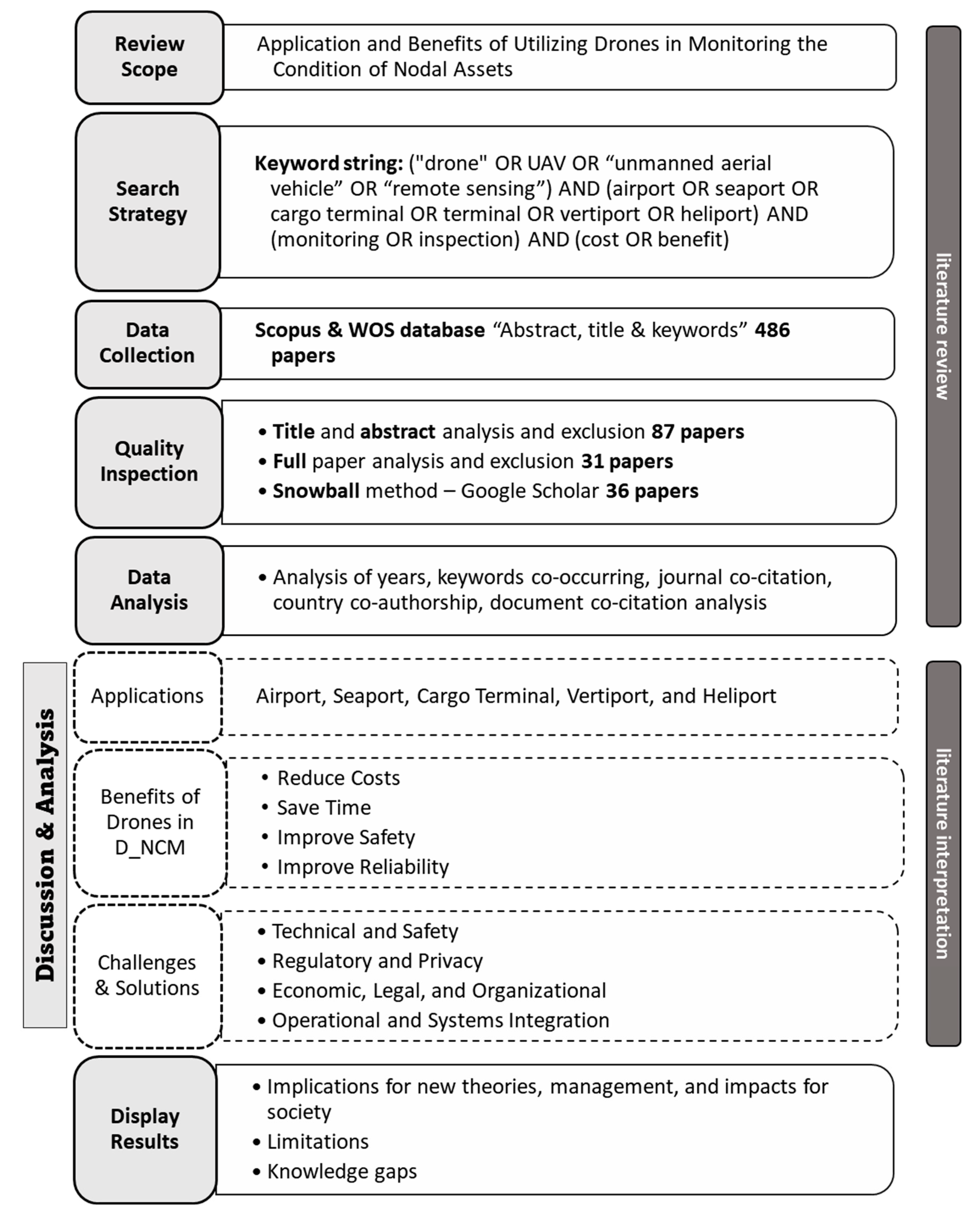
This research adopts the SLR methodology, following the seven-step process described by Cooper (2015), and as shown in
Figure 1 [
18]. The SLR methodology prioritizes rigorous data collection, analysis, and interpretation to effectively synthesize existing research. The review began by setting an objective: evaluating URS applications along with their associated costs and benefits to ensure a comprehensive and targeted analysis of relevant literature. This approach allows for a focused review, capturing high quality studies specific to UAV applications in nodal asset monitoring. Next, the authors established a literature search strategy by selecting literature databases and keywords. Scopus and Web of Science (WOS) served as the primary databases because of their broad coverage of peer-reviewed academic materials. The search criteria encompassed terms such as (“drone” OR “UAV” OR “unmanned aerial vehicle” OR “remote sensing”) AND (“airport” OR “seaport” OR “cargo terminal” OR “vertiport” OR “heliport”) AND (“monitoring” OR “inspection”) AND (“cost” OR “benefit”) in titles, abstracts, and keywords.
Conference papers became relevant only when there was a shortage of peer-reviewed journal articles. The third and fourth steps of the SLR procedure focused on data extraction and assessing article quality. The initial analysis yielded 486 articles from 2015 onward. A review of titles and abstracts eliminated unrelated and redundant materials, retaining 87 relevant articles. A more detailed analysis highlighted 31 articles addressing benefits and applications. The snowball method with Google Scholar added 8 more articles, tallying 36 articles from 2016 to 2023. In the fifth step, the CiteSpace application (version 6.2.R2) produced visualizations of literature patterns and trends. The sixth step involved presenting and interpreting findings through content analysis. The last step outlined the research outcomes, emphasizing the limitations and various implications of the study.
3. Analysis and Results
The subsequent sections detail the annual distribution of papers, document co-citation analysis, keyword co-occurrence network, country co-authorship network analysis, and journal co-citation analysis.
3.1. Distribution by Year and Asset
Figure 2 presents the annual distribution of publications from 2016 to 2023, demonstrating the trend of publication output within this period. Of the 36 papers analyzed, the most frequently covered asset was airports, with 18 papers dedicated to them. Seaports came next, serving as the subject of 8 papers. The first paper in this field, published in 2016, focused on seaport monitoring. There was a significant increase in papers on airport monitoring in the years 2020 and 2022, illustrating the growing interest and advancements in this area immediately following COVID-19.
3.2. Document Co-Citation Analysis
Quantitative analysis of co-cited references enables precise identification of prevailing research directions within a specific domain. CiteSpace primarily features cluster analysis, which partitions extensive datasets into distinct, interrelated units to systematically explore research trends and trajectories.
This study analyzed the top 50 co-cited references for each time slice.
Figure 3 presents a document co-citation network characterized by 325 nodes and 1160 links. The low network density of 0.022 suggests that while there is a connection among the existing research topics within the domain, there is ample room for further exploration and new research paths. The high weighted mean silhouette score of 0.9273 indicates that the documents are well-clustered into coherent and relevant topics. Similarly, the modularity score of 0.7856 confirms the presence of distinct, well-defined research clusters within the broader URS field [
19]. The Log-Likelihood Ratio (LLR) labels of the clusters reflect the research frontiers in this knowledge domain, and the network also displays the top-cited research topics based on their frequency.
In
Table 1, the network is segmented into eleven distinct clusters, each with a size greater than 19. The size of clusters refers to the number of cited references that make up a cluster. Cluster #7, labeled “using UAV”, has a mean year of 2016 and the highest silhouette score of 1. The primary research topics in this cluster are artificial intelligence (AI) and automation, highlighting the initial stages of drone utilization for infrastructure condition monitoring in conjunction with AI. Cluster #1, labeled “Possibilities of UAS for maritime monitoring”, has a mean year of 2018 and features hot topics such as remote sensing and aircraft control, indicating the advancement of this promising technology. Cluster #0, the largest cluster of 2019 and within the URS field, labeled “airport safety”, has a size of 47. This cluster encompasses top research topics such as drones and airport environment. The two largest clusters of 2021, clusters #5 and #6, labeled “airport environment” and “runway”, respectively, both directly highlight drone applications in airport monitoring with hot topics like airfield pavement, aircraft detection, and object detection. Other topic clusters include data analytics, containers, inspection, image analysis, antennas, and deformation.
3.3. Keywords Co-Occurrence Analysis
Keyword co-occurrence analysis aims to uncover emerging trends, key themes, research focus, and promising directions in each field. The study spans from 2016 to 2023 and breaks this period into annual time slices. Within each slice, the analysis identifies the top 50 cited or frequently occurring items. The network modularity
Q of keyword co-occurrence yielded a result of 0.7326, and the silhouette score was 0.9283, surpassing the 0.3 and 0.4 thresholds, respectively. This signifies a well-structured network and satisfactory outcome [
19,
20].
The centrality of a node is based on its position in the keyword network and its connections to other nodes [
21].
Table 2 highlights keywords with centrality values exceeding 0.15 and their count, such as “Inspection” (centrality: 0.6), “Aircraft” (centrality: 0.59), and “Container” (centrality: 0.38). The study uses CiteSpace for cluster analysis of co-occurring keywords and identifies 10 distinct clusters. The average silhouette (
S value) serves as a metric to assess clustering quality. Generally,
S > 0.5 suggests reasonable clustering, while S > 0.7 indicates convincing clustering. Each of the identified clusters has a silhouette value greater than 0.8, signifying the results are satisfactory (
Table 3) [
20].
For a better understanding of these clusters, the SLR visualizes them in a co-clustering timeline, as displayed in
Figure 4. The visualization underscores the significance of each cluster while unveiling their temporal interactions. Network nodes represent keywords, and links display their connections. Node rings reflect the keyword frequency in each time slice, and word font size denotes relative occurrence frequency. The pink outer circle surrounding the individual circles represents the centrality of the respective keywords. This method offers a lucid and intuitive depiction of the research domain’s evolution by highlighting major trends and patterns across time [
22].
Analysis shows that “artificial intelligence” and “UAV” have been key subjects in research since 2016. In 2018, the research focus expanded to include “airport” and “antennas.” The following year, 2019, saw the emergence of research topics centered around “inspection”, “aircraft accidents”, and “aircraft”. In 2020, the fields of “aircraft detection”, “monitoring”, and “containers” experienced a significant increase in attention.
By 2022, research areas such as “object detection”, “airport security”, “automation”, and “deep learning” had gained significant traction. The color-coded clusters and their corresponding nodes indicate the enduring popularity of certain clusters, such as “foreign object detection” (cluster #0) and “artificial intelligence” (cluster #2), which have been prominent since 2016. In contrast, clusters like “monitoring” (cluster #5) and “remote sensing” (cluster #4) have emerged more recently. However, some clusters, including “photometry” (cluster #6) and “sensing technology” (cluster #9), experienced a decline in research interest over time. This demonstrates the fluid nature of research trends and the varying degrees of relevance among topics in the ever-evolving field of URS.
Table 4 lists the top seven keywords with the most prominent citation bursts in this analysis. The concept of a “burst keyword” pertains to keywords that experience frequent citations over a specific period, with burst detection quantifying the pace at which these keywords gain prominence [
21]. In the initial years of URS research, the emphasis was on expanding technologies, as evidenced by “UAV” and “Drone” being the dominant keywords. Recent research concentrated on technology development and applications, with “airport runways” and “civil aviation” as core keywords.
3.4. Country Co-Authorship Analysis
Figure 5 presents the country co-authorship network for URS research, highlighting the collaborative relationships among various nations. The minimum spanning tree algorithm pruned the network. The dimensions of each node correspond to the volume of papers produced by authors from that country. Line-connecting nodes signify co-authorship between respective countries, with the number of lines denoting the extent of such collaborations. The analysis of 36 papers included in this study encompasses authors from 20 countries, highlighting the widespread research interest in URS.
Table 5 lists the top 8 countries in terms of publication output within the URS domain. A surge in citation frequency signifies substantial impact, while countries possessing centrality hold more influence in the field. Only two countries have centrality: Italy (three publications), and United Kingdom (two publications). In the realm of URS research, the United States holds the top position with eight publications, followed by China, which ranks second with six publications. Both Italy and Germany share the third rank, each contributing three publications to the field.
3.5. Journal Co-Citation Network
A thorough analysis of 1273 references cited across 36 publications in the URS domain identified the most influential journals.
Figure 6 shows the co-cited journal network by mapping journals that exhibited a significant co-citation frequency within each time slice. The size of each node signifies the co-citation frequency of a specific journal within the dataset, implying that these journals have contributed substantially to the URS research area and consequently receive more citations. The network reveals a pronounced correlation among co-citations in journals like
Sensors and
Remote Sensing alongside a comprehensive network for affiliated journals. The network illustrates the recent emergence of certain journals, such as
IEEE Access.
Table 6 displays a ranking of journals with the most pronounced citation bursts, based on the intensity of the burst. These citation bursts signify that publications within these journals have garnered a considerable number of citations within a brief period. As URS research is in its initial stages of advancement, the concentration is on aspects related to sensors and remote sensing within the field. Several journals currently experiencing rapid growth, such as
Transportation Research Part C, will undoubtedly continue to lead the field of transport modeling.
4. Discussion
The subsequent subsections discuss the research conducted on various drone-based monitoring applications for nodal transportation assets. The analysis is deeply rooted in expert knowledge, ensuring that the applications discussed are relevant and provide actionable insights for practitioners. The integration of expert insights with these systematic reviews provides a refined perspective to enhance the value of the findings.
4.1. Applications in Airports
Table 7 lists the benefits of using drones in the context of airport operations.
4.1.1. Runway Inspections
Airport runways require frequent inspections due to their pivotal role in operations. These inspections evaluate runway markings, signs, tree lines, and the overall condition of the pavement. Traditionally, maintenance teams inspect runways multiple times daily, identifying debris, cracks, and surface imperfections [
37]. Traffic and weather factors contribute to runway degradation, demanding routine checks. Experts recommend visual inspections at least four times daily. During adverse conditions like ice or slipperiness, friction tests on runways become more frequent than in dry periods [
23,
38].
Drones enhance the inspection process by boosting efficiency and thoroughness, proving indispensable for airport operations. Ciampoli et al. (2020) emphasized monitoring deformations, especially in runways built on substrates such as clayey soil. They employed the persistent scatterers interferometry (PSI) technique, a potent remote sensing method for gauging ground deformations. By analyzing a series of COSMO–SkyMed satellite images from January 2015 to April 2019, they evaluated Runway 3 at the “Leonardo da Vinci” International Airport in Rome, Italy. Their research affirmed the PSI technique’s precision and effectiveness in assessing runway deformations [
28]. Kim et al. (2021) proposed a framework to inspect runway design codes (RDCs) by using imagery from drones. This imagery, crafted by merging scale-invariant feature transform and best bin first algorithms, showed accuracy on par with manual inspections, underscoring the drone’s utility in airport evaluations [
15].
4.1.2. Obstruction Monitoring
Ensuring a clear path for safe takeoff and landing is crucial, as mandated by Part 77 of the Federal Aviation Regulations. Airports must delineate imaginary surfaces within their designs to identify potential hazards arising from vegetation, construction, or nearby changes. Historically, they used aircraft photography and ground inspection tools for obstruction analysis, often incurring prohibitive costs from employing specialized equipment and expertise. With drone technology and Geographic Information Systems (GIS), airports can now conduct inspections more efficiently, process data in-house, and generate compatible GIS files [
28].
Amit & Mohan (2022) presented a real-time fusion method, selecting participating clients based on local model performance [
24]. They created and assessed a custom dataset depicting actual airport conditions using both the You Only Look Once version 3 (YOLOV3) and Faster region-based convolutional neural network (RCNN) algorithms [
24]. Wang et al. (2020) developed a system to oversee airport obstacle-free zones, targeting a decrease in drone and airplane incidents [
25]. This system could identify, track, and remove airborne items and small planes. Their work revolved around creating a quadcopter dynamic model, a two-degrees of freedom (2-DOF) pan-tilt-zoom (PTZ) model, and an attitude back-stepping controller with disturbance offset. The combination of the YOLO and kernelized correlation filter (KCF) algorithms led to an effective autonomous target recognition and tracking scheme [
25].
Noroozi and Shah (2023) crafted a framework that capitalized on the YOLO object detector models, with the YOLOV4 model excelling in speed and accuracy [
26]. Papadopoulos and Gonzalez (2021) offered a model to pinpoint foreign object debris (FOD) on runways. Their design featured a low-flying drone with an RGB camera and an AI detector, trained via deep learning. This model, tested on different FOD types and lighting conditions, displayed impressive accuracy, indicating its utility in minimizing runway interruptions and heightening operational efficiency [
28].
4.1.3. Pavement Condition Surveillance
The Federal Aviation Administration (FAA) advocates for proactive maintenance and rehabilitation of pavements in good condition. Such timely interventions not only extend the lifespan of the pavements but also yield significant cost savings. In fact, preventive measures cost an estimated four to five times less than repairing pavements already in “fair” or “poor” condition [
39]. Pietersen et al. (2022) introduced a drone-based method for semi-automated airfield pavement assessment. This approach, while echoing the manual ASTM Pavement Condition Index (PCI), leveraged a convolutional neural network (CNN) specifically trained to detect pavement distresses. When tested at an auxiliary airfield in Colorado Springs, the method aligned closely with traditional manual inspection results [
12].
4.1.4. Wildlife and Drone Detection
Wildlife strikes in the aviation industry cause approximately
$950 million in damage annually in the United States and
$1.3 billion globally, averaging 26 incidents per day [
29]. Airports certified under Part 139 must have a wildlife hazard mitigation program, embedding wildlife control as a core component of their operations. This program entails identifying the species at the airport, pinpointing habitats and food sources that attract wildlife, and deploying effective control methods, both lethal and nonlethal, to keep wildlife at bay. Because birds constitute 97% of these strikes, emphasizing bird management is crucial [
40]. In this context, Shanliang et al. (2022) unveiled a Deformable DETR-based algorithm to accurately detect both drones and birds in airport clear zones, leveraging visible light imagery [
30]. While radar remains the most accurate detection system, its effectiveness increases when supplemented with visual detection, despite the latter’s limitations in focusing on distant small objects. Radio frequency (RF) or acoustic detection methods further contribute to safety by identifying unauthorized drones in no-fly zones, and, when combined with radar, they facilitate precise object tracking in terms of altitude and distance [
32].
4.1.5. Airfield Light Assessments
Drones can streamline airfield light inspections, ensuring visibility and safety according to FAA and International Civil Aviation Organization (IACAO) standards. Daily twilight or nighttime inspections confirm light functionality while periodic checks ascertain adequate intensity, which can diminish over time due to aging, dust, dirt, and rubber deposits from aircraft braking [
41]. Traditionally, a vehicle-mounted photometric measuring device checks light intensity. However, drones provide an advantage as they can fly at varying heights without the time-consuming task of adjusting vehicle-mounted calibration equipment [
29]. Sitompul et al. (2019) proposed a model using a drone to carry the photometric instrument, which includes two wirelessly communicating subsystems for data acquisition and data processing. They successfully tested the model on Thorn EL-EAH runway edge lights at the Indonesia Aviation Engineering Center, providing detailed light intensity diagrams for comparison against standards [
33].
4.1.6. Cybersecurity Measures
The Transportation Security Administration (TSA) plays a critical role in overseeing airport security, a necessity given each airport’s connection to the national airspace system. Drones offer an efficient means for enhancing this security while minimizing disruption to aeronautical operations. Drones excel in rapidly traversing challenging terrain, conducting swift surveillance, and accessing hard-to-reach areas, thus underscoring their utility in perimeter defense [
29]. The FAA reports more than 100 unauthorized drone sightings each month, highlighting an urgent need for drone-based identification systems to prevent costly disruptions. For context, unauthorized drone activities led to multiple closures of Dubai Airport in 2016, resulting in substantial operational and financial setbacks. Utilizing drones for security can significantly reduce such downtimes, thereby boosting operational efficiency [
42].
In their study, Lykou et al. (2020) explored incidents involving drones near airports and assessed sensor technologies capable of mitigating rogue drone activities. Although counter-drone technologies (C-UAS) present obvious benefits, their deployment in protecting airports brings its own set of challenges. The researchers examined three different attack scenarios to offer effective C-UAS protection plans, shedding light on the technology’s limitations within the aviation sector. The team proposed a resilience strategy to fortify airport defenses against potential aerial threats from drones [
36].
Similarly, Shvetsova and Shvetsov (2021) presented a strategy to elevate drone safety in airport environments. They advocate restricting drones to specific flight corridors to minimize collision risks and propose relaxing the existing limitations on drone usage within airport vicinities [
34].
4.1.7. Flight Inspections
Drones have replaced conventional methods for inspecting terrestrial navigation aids (NAVAIDs). Unlike traditional flight inspection, the drone-based system enables near-stationary overflight in critical areas and provides extended observation periods, eliminating the need for manned aircraft carrying costly measurement equipment and antennas [
35].
4.2. Applications in Seaports
Drones offer a specialized capability to either execute or enhance a range of maritime and port-related tasks currently performed manually or inefficiently.
Table 8 shows different benefit areas of drone-based monitoring in this sector.
4.2.1. Port Monitoring
To maintain functionality, ports require continuous assessments. Drones critically contribute to this by swiftly identifying and addressing structural deterioration in port facilities. They not only survey port machinery but also facilitate the timely mitigation of damage from harsh maritime climates to preserve the operational state of facilities. Moreover, drones provide real-time video streams for captains, enabling smart pilotage to navigate vessels safely into crowded port berths [
48].
4.2.2. Infrastructure Inspection
Drones enable the generation of 3D digital twins of port structures, thus enhancing monitoring and maintenance capabilities while reducing safety risks during maritime infrastructure inspections. These remote inspections improve operational efficiency and minimize risks to human surveyors. For example, drones conduct routine checks on hulls, cargo and water ballast tanks, coating systems, and structural integrity. They also facilitate inspections of flare stacks, crane tops, and confined spaces and improve debris detection [
45]. Such remote capabilities extend to areas difficult for surveyors to access, such as hull exteriors or tank interiors [
43]. By replacing industrial climbers in container crane inspections, drones can lower costs and increase the reliability of outcomes [
17]. Moreover, drones increase the accuracy of identifying structural issues and reduce the number of necessary inspection points. They facilitate ongoing monitoring of conditions on drilling platforms and identify quay abnormalities which may arise from ship damage during docking or environmental factors like ice fractures. These conditions are often challenging for port officials to monitor consistently. Drones perform quayside inspections that allow for detailed evaluations of areas inaccessible to traditional inspection vessels due to spatial constraints [
44,
48].
4.2.3. Ship Inspection
Drones play an essential role in various stages of ship inspection: repair, conversion, new building processes, and pre-handover assessments. They are instrumental in inspections before reactivating ships. Additionally, they calibrate ship antennas and test emissions of incoming ships, with a focus on monitoring sulfur and carbon dioxide levels [
46].
4.2.4. Oil Spill Detection
Effective seaport surveillance and water environment pollution control mandate reliable oil spill monitoring and detection. Drones serve this function capably by deploying either multispectral optical and thermal sensors or active microwave-radar systems. These technologies enable accurate tracking of oil spills, essential for quick response during accidents in the oil sector, such as oil leaks from ships or gas leaks from oil rigs [
47].
4.2.5. Emergency Response
Drones find applications in specialized scenarios including flameless fire detection, post-incident damage assessments, and control of piracy-prone areas. During Hurricane Wilma, the Institute for Safety Security Rescue Technology deployed an AEOS-1 drone to inspect seawalls, docks, and bridges. This drone independently assessed damage at the Marco Island Yacht Club. For enhanced situational awareness, a drone operator navigated the device through areas otherwise unreachable or hidden from view [
49].
4.2.6. Port Security Monitoring
Drones contribute to border security, assist in search and rescue operations, and identify both legal and illegal ships [
50]. They can scan maritime environments for potential hazards like red tides and oil spills. Additionally, drones bolster terminal security and monitor water environments, aiding in the identification and neutralization of unauthorized marine drones [
47].
4.3. Applications in Cargo Terminals
A terminal operates within a complex transportation system with the primary function of handling containers. This handling involves tasks such as loading, unloading, horizontal movement, sorting, and storing containers. The terminal employs various cranes and vehicles for vertical and horizontal transportation. Drones can significantly enhance the management of terminal operations and equipment [
51].
Table 9 lists different applications of drones in cargo terminal condition monitoring.
4.3.1. Operations Management
Drones aid in enhancing site operations by monitoring traffic flows and boosting container stack efficiency. They also help identify and curb unsafe behaviors, such as drivers leaving their cabins, thereby ensuring improved safety measures on-site [
52].
4.3.2. Regular Inspections
Drones streamline rooftop and crane inspections by illuminating blind spots in high-density container stacks. Additionally, they monitor the alignment and functionality of gantry cranes on railway sidings, thereby minimizing unexpected malfunctions because of ground settling. In a related study, Bajauri et al. (2022) introduced the ABC-Inspekt project, which automates container crane inspections through drones. The initiative leverages drones for efficient, cost-effective image capture of cranes. Stored in a database, these images are available to operators and an automated analysis system that detects potential flaws [
13].
4.3.3. Automated Systems
Drones serve as intermediate nodes to maintain communication among intelligent autonomous vehicles (IAVs) in automated container terminals (ACTs), thereby preventing disruptions in control operations. In a related study, Bahnes et al. (2022) proposed a distributed approach that employs drones to manage IAV traffic at challenging intersections within container yards. Conventional communication methods falter due to signal blockage by stacked containers. The algorithm used drones as relay nodes to sustain unbroken communication and ensure collision-free operations at these intersections. Simulations validate the effectiveness of this drone-based approach, confirming its capacity for reliable communication, secure intersection management, and efficient IAV traffic flow [
52].
4.4. Applications in Heliports
Three primary types of heliports exist: general aviation (GA), transport, and hospital. Their location categorization includes elevated heliports, commonly found on buildings, and ground heliports [
53]. The following details outline various applications of drones in this sector.
Table 10 shows different potential applications of drones in monitoring the condition of heliports.
4.4.1. Touch Area Monitoring
In pre-landing and take-off inspections, the focus remains on landing pad monitoring. The detection of debris, snow, or ice on this pad is critical for ensuring safety and preventing accidents. Drones carry out inspections of heliport surfaces, dimensions, and markings to maintain compliance with safety regulations.
4.4.2. Landing and Take-Off Area Monitoring
Regarding the approach and take-off flight paths, obstacle inspection is of paramount importance. The drones’ ability to provide a bird’s-eye view proves particularly useful during night landings to confirm adequate lighting conditions. Inspection extends beyond the physical structures and equipment to include helicopter operational support systems such as radio and meteorological facilities. Staffing arrangements also fall under this purview, ensuring there are adequate staff filling essential roles like helicopter landing officers, emergency response teams, and refuelers.
4.4.3. Safety Area Surveillance
Regarding heliport safety measures, drones conduct assessments that include verifying the presence or absence of a functional windsock and evaluating obstruction factors such as markings and lighting. These drones also consider miscellaneous operational requirements for helicopters, thereby enhancing overall heliport safety. Drones monitoring security measures can scan the airspace for trespassers or unauthorized drone activity. They also assist in implementing safety measures during high-risk or sensitive operations, thereby enhancing the security of the heliport.
4.4.4. Emergency Response
When it comes to fire emergencies, assessment activities include examining the heliport’s emergency, rescue, and fire-fighting facilities and procedures. Drones also perform regular functionality checks of fire suppression equipment to ensure a state of readiness for emergencies.
4.4.5. Security Measures
Airspace monitoring for trespassers or unauthorized drone activity constitutes another crucial dimension of heliport security. Drones inform the implementation of safety protocols during high-risk or sensitive operations, thereby augmenting the heliport’s overall security framework [
54].
4.5. Applications in Vertiports
The development of drone infrastructure is currently in an exploratory phase. Companies are considering various strategies, such as building dedicated vertiports or adapting existing structures like airports, heliports, and parking garage roofs [
55]. Irrespective of the chosen approach, thorough inspections are mandatory before initiating operations, throughout the testing phase, and at regular intervals afterward. Drones prove to be highly effective tools for these inspections [
56]. The following sections will elaborate on the specific uses of drones in monitoring such infrastructures, as summarized in
Table 11.
4.5.1. Landing Area Surveillance
Drone applications in the landing area primarily revolve around inspecting landing and departure pads, monitoring vertiport ramp areas, and overseeing aircraft positions relative to their planned trajectories within the vertiport operations area (VOA). Ariante et al. (2022) introduced a specialized support control system for drone vertical landing and takeoff designed to navigate crowded and complex environments. This system integrated a real-time LiDAR sensor for obstacle detection, a Raspberry Pi 3 for efficient data processing, and a ground control station for seamless data management. Tests revealed satisfactory results for identifying obstacles and in executing precise landings within predefined safe zones, even in the absence of GNSS-based navigation [
57].
4.5.2. Facilities Inspection
Drones can significantly enhance the management of terminal operations and equipment. In vertiport management, drones offer a multifaceted approach to oversight and maintenance. These systems scrutinize passenger and cargo gates to streamline flow and enhance security. They also patrol both short-term and long-term parking areas to pinpoint unauthorized activities, and rigorously inspect charging and fueling stations to ensure structural integrity. In addition to these tasks, the technology evaluates essential structural components such as landing pads and vital operational elements like signage and lighting. The technology is crucial for real-time progress tracking and identifying issues during construction or expansion. Safety audits in all vertiport operational zones also confirm compliance with regulatory standards.
4.5.3. Operational Support
Operational support encompasses weather and noise level monitoring as well as traffic flow and congestion management. Drones can provide real-time information that enhances decision-making for increased efficiency and safety. Shao et al. (2021) investigated the operation of drones in multi-vertiport systems (MVS-TA) within economically developed regions [
58]. The researchers introduced an adaptive control system (ACS), incorporating both a multi-ring structure and backpressure-based junction control rules. This ACS also integrates a scheduling model that considers eVTOL power limitations and prioritizes approach-departure flights. Comparative results reveal that the ACS surpasses traditional control systems in terms of both operational efficiency and safety, particularly in regions experiencing high flight density [
58].
4.5.4. Security Monitoring and Incident Response
Drones can play an essential role in perimeter and internal surveillance, helping detect unauthorized access or suspicious activity. Their specialized sensors can help to detect and neutralize potential drone threats, provide real-time monitoring during incidents for situational awareness, coordinate with security personnel for improved response, and record and archive footage for incident investigation and analysis.
4.5.5. Emergency Response
In case of emergencies, drones can enable rapid assessment and real-time visuals to responders. This includes fire safety inspections and monitoring, and monitoring wildlife activity to reduce the risk of strikes.
4.6. Benefits of Drones in URS
The next subsections summarize the benefits of drones in reducing costs, saving time, enhancing safety, and improving reliability.
4.6.1. Reduce Costs
In multiple sectors of nodal transportation assets, cost reduction manifests in various forms when incorporating drone technology. Accelerating data collection decreases the labor time required, which in turn minimizes labor costs. Additionally, drones replace the need for specialized vehicles and hardware typically used for inspections, cutting both initial investment and ongoing operational costs, such as fuel and maintenance. Traffic management benefits as well; the technology negates the need for lane or road closures during inspections, minimizing both costs and economic impacts of delays. Moreover, drones require fewer personnel to operate them for data collection and inspections, further reducing labor costs. For long-term asset monitoring, the versatility and adaptability of drones present cost-effective solutions. Whether monitoring an airport runway, a seaport dock, or a cargo terminal, a single investment in drone technology can fulfill varied monitoring needs, maximizing the returns on investments.
Compared to traditional aerial mapping methods involving crewed aircraft—which can cost between
$8000 and
$10,000 per runway—more economical alternatives exist. For example, South Carolina chose to use SenseFlyEBee RTK v.2016 and ArcGIS software v.10.8 for their aerial mapping, with a total expenditure of approximately
$50,000 [
59]. According to the South Carolina Aeronautics Commission, this initial investment will pay for itself after the mapping of just five airports, indicating a return on investment within one year [
29].
Table 12 shows the summary of cost and time reductions.
4.6.2. Save Time
Drones can perform many tasks more efficiently, reducing both labor and time. With their speed and versatility, drones can cover extensive areas, both vertically and horizontally. For instance, during pavement inspections, rather than a person walking across the runway, drones can collect comprehensive data without risking human safety. Additionally, they can swiftly survey the tops of buildings, towers, or instruments, leading to a significant decrease in labor hours and an enhancement in efficiency [
60]. Monitoring runway conditions with conventional methods requires 6 to 8 h, while drone technology achieves this in just 30 min [
61]. Drones can help to execute missions seven times faster and at a fraction of the cost of ground-based activities, reducing the number of officers necessary for patrols and saving
$1.5 million within three years [
62].
Table 12.
Cost and Time of Traditional and URS.
Table 12.
Cost and Time of Traditional and URS.
| Application | Reference | Traditional Monitoring | Drone-Based Monitoring |
|---|
Aerial
Mapping (Cost) | [59] | $8000–$10,000 per runway; $75,000 for four airport approaches | Approximately $50,000
(Cost recouped after 5 airports) |
Pavement Condition
Assessment (Time) | [61] | 6–8 h | 30 min |
Patrols
(Cost and Time) | [62] | Higher cost, slower | Saved $1.5 million over three years; 7 times faster |
Cargo Loading and
Unloading (Time) | [63] | Longer duration | 15-min time reduction per manual loading and unloading |
DFDS, a European shipping and logistics company, in partnership with UAS Denmark and Lorenz Technology, integrated drones and AI to streamline their inspection process. Utilizing the Matrice 210’s Onboard SDK and DJI’s Zenmuse XT2 camera, they achieved quicker object identification and issue detection. This integration resulted in improved decision-making processes and faster trailer identification and positioning. The system achieved a 15 min time reduction per manual trailer loading and unloading, leading to reduced fuel consumption and CO
2 emissions [
63].
4.6.3. Improve Safety
In environments like airports and vertiports, where stringent safety standards and high traffic demand a low margin for error, the role of drones in monitoring is both safe and efficient. They excel in surveilling runway conditions, taxiways, and air traffic control structures [
64]. Additionally, they serve as tools for mitigating wildlife hazards, notably reducing the risk of bird strikes and other issues that threaten safety.
For seaports, traditional monitoring methods often struggle to cover the expansive docking areas, shipping lanes, and storage facilities effectively. Here, drones fill this gap by offering comprehensive aerial views. These aerial platforms can quickly identify potential hazards and facilitate timely corrective actions, thereby mitigating environmental damage and safety risks.
When considering cargo terminals, which are hubs of frenetic activity involving multiple vehicles and heavy machinery, drones contribute significantly to safety. They monitor operational flow from a vantage point that minimizes risks, and simultaneously assess the structural integrity of vital infrastructures like cranes and storage racks. By confirming compliance with safety regulations, drones reduce the likelihood of structural failures and subsequent injuries or loss of life.
4.6.4. Improve Reliability
Real-time monitoring through drones furnishes operators with instantaneous data, a crucial feature in fluctuating environments such as airports and seaports. Immediate access to this data enables swift decision-making, essential for sustaining reliable operations. The technological capabilities of drones, including high-resolution, 360-degree, bird’s-eye, and 3D views, surpass those of conventional surveillance methods. These enhanced viewpoints facilitate more precise evaluations, thereby bolstering the reliability of both maintenance operations and safety measures. Drone-derived data can expedite the inspection of runway pavements, tasks that traditionally consume hours. Drone imagery currently boasts a resolution of 0.71 inches, significantly finer than the 11.8 inches resolution of the Environmental Systems Research Institute (ESRI) base map, enabling easy detection of minute cracks on the runway [
27]. The data precision provided by drones, with horizontal accuracy reported as 4 inches and vertical accuracy of 6 inches [
60], suffices for the needs of many airports. Drones maintain operational capabilities in adverse weather conditions, environments often deemed too risky for human inspectors. Their resilience ensures that vital inspections and monitoring tasks proceed without interruption, fortifying the asset’s overall reliability.
4.7. Operational Challenges
The operational challenges associated with UAV deployment for nodal transportation monitoring are profound. UAVs are vulnerable to various forms of cyber attacks, including hijacking, spoofing, and jamming, which can compromise both the safety of operations and the integrity of collected data. For example, perpetrators can intercept and misuse the video records captured by UAVs, raising significant privacy and security concerns. The low level of cyber protection currently available for commercially used UAVs compounds these risks, making them susceptible to unauthorized access and control. The sections that follow expand on these and other challenges.
4.7.1. Technical and Safety Challenges
Drones require a maintained visual line of sight [
27]. They have limited payload capacity, flight endurance, and sensitivity to varying light and weather. Flight speed affects image clarity. Large datasets necessitate sophisticated analysis. On the safety side, hardware and software faults, including faulty connections, programming mishaps, and signal disruptions, present risks. Human mistakes can lead to accidents, such as drone collisions with structures or personnel. Drone noises can distract workers, and rotor-induced dust can pose health issues. Cyberattack threats further complicate safety considerations [
65].
4.7.2. Regulatory and Privacy Concerns
Drones operate under strict regulations, including speed caps at 100 mph, altitudes below 400 ft, and requirements for prior approvals. Existing regulations, particularly for smaller drones, are unclear [
29]. Drones’ ability to capture visual data raises privacy issues, necessitating rigorous data handling protocols [
31]. There is also a risk of accidentally recording regulated activities or people, highlighting the need for diligent operations.
4.7.3. Economic, Legal, and Organizational Challenges
The changing landscape of drone capabilities and their costs calls for a sound economic justification for nodal use. Beyond direct costs, costs for data management, safety protocol development, and specialized system administration arise. Navigating the FAA’s regulatory web often requires expert legal insights [
25]. Insurance expenses, influenced by assets factors and drone uses, are variable [
36]. Quantifying the economic benefits of drones is complex. Organizationally, the tasks of drone registration, skill acquisition, and insurance navigation present hurdles.
4.7.4. Operational and Systems Integration Challenges
Drones should smoothly fit into asset routines without causing interference, particularly in sensitive operations like runway checks. Procedures to handle lost-link situations are crucial to prevent drone hazards during communication losses. Assets must also incorporate drones into their safety management systems, requiring comprehensive risk evaluation and synchronization with current processes [
3].
5. Research Gaps and Limitations
The limited adoption of UAVs for nodal transportation asset monitoring can be due to several significant challenges, primarily revolving around security and safety risks. These include the potential for misuse, hijacking, spoofing, jamming, and cyber attacks, which pose serious threats to operational integrity and data security. The publications examined challenges, opportunities, and results specific to URS. However, they lack a comprehensive benefits analysis and do not encompass all applications in a single study; certain applications remain unmentioned. This research fills that gap through analysis of the benefits, applications, and challenges associated with URS.
5.1. Implications for New Theories
The use of drones for nodal asset monitoring not only enhances operational efficiencies and reduces costs but also introduces new theoretical frameworks that redefine asset management practices. A notable theoretical advancement lies in “Distributed Asset Intelligence”. Centralized control systems, traditionally used for asset monitoring, pose significant costs and the risk of single points of failure. In contrast, the modular and easily deployable nature of drone-based systems promotes decentralization. This evolution lays the foundation for theories that explore how decentralized, drone-empowered systems may offer more robust, flexible, and resilient asset monitoring networks.
Beyond decentralization, the capacity of drones for real-time data collection fosters advancements in “predictive analytics in nodal asset management”. Traditional theories often emphasize regular maintenance cycles and scheduled inspections. However, the real-time data provided by drones enable a shift toward predictive, algorithm-driven models that preemptively identify system failures. This innovative approach has the potential to transform existing asset management theories from reactive methodologies to predictive frameworks. This SLR offers a detailed application into these evolving theories and their benefits, serving as a vital resource for organizations.
5.2. Implications for Management
Organizations implementing URS applications confront a range of management challenges. These encompass data management, information technology (IT) infrastructure, workforce organization, adapting to evolving technology, long-term cost management, regulatory compliance, environmental considerations, and alignment with organizational vision. Agencies must rigorously address these challenges to guarantee the optimal execution and deployment of URS applications.
Drone monitoring can markedly decrease both the time and labor required for inspecting large-scale transportation assets. While procuring drone technology and facilitating training incurs an initial cost, the eventual long-term savings prove considerable. Drones collect extensive data, necessitating a robust IT infrastructure and a workforce skilled in data handling, analysis, and retrieval. Hence, managers must give paramount importance to both operational safety and adept data management. The dynamic nature of drone technology mandates perpetual training for operators. As technological strides occur, managers need to actively assimilate and apply these advancements, maintaining a competitive edge in operations. When integrating drones, alignment with the organization’s broader vision is essential. This adoption transcends mere technological progression; it should synchronize with enduring strategic intents, anchoring the technology to the organization’s broader mission and goals. Environmental considerations, such as responsible battery disposal and mitigating potential disruptions to wildlife warrant managerial attention to ensure sustainable operations. For drones to realize their maximal utility, their melding into existing operational and IT frameworks must be flawless. This integration requires a managerial approach that synergizes technological proficiency with strategic vision.
5.3. Implications for Impacts to Society
Drone integration into nodal asset monitoring offers notable benefits to rural communities that frequently face underdeveloped transportation infrastructure. These advantages, which include heightened safety and efficiency, prove especially valuable where geographic and logistical challenges impede rapid response and maintenance. The cost-optimizing potential of drones provides significant financial relief to rural areas with limited resources for transportation upkeep. Such cost savings can then serve other urgent societal needs in these communities, such as healthcare and education. Additionally, drones offer the advantage of real-time environmental data, enabling early issue detection and prompt remediation, particularly crucial for rural areas where problems may go unresolved for extended periods.
Despite these benefits, drone usage raises concerns about individual privacy due to increased aerial surveillance. Achieving a balanced approach to efficiency and privacy rights becomes crucial. Noise pollution from drone operations also threatens local wildlife and residential tranquility. On the upside, technological advancements in drones can drive educational initiatives, yielding a knowledgeable future workforce that benefits rural communities. As society grows accustomed to drone presence, shifts in cultural perspectives on surveillance, privacy, and technological dependency may occur.
Considering drones’ growing public presence, the responsibility lies with government and regulatory bodies to formulate comprehensive, balanced policies. These policies should ensure the safe, ethical, and efficient operation of drones while addressing societal reservations. With the fast-paced evolution of this field, maintaining informed and proactive stances proves essential for all stakeholders, from policymakers to the public.
5.4. Limitations
The study identified a few relevant papers, underscoring the emerging status of this technology. Given the limited research on the technology’s various applications, the classification of its applications, benefits, and challenges might have missed certain facets. In particular, the authors found no existing studies or projects on drone-based monitoring for some assets. The lack of data on the financial implications further constrained an exhaustive economic assessment, affecting the study’s relevance in decision-making scenarios.
5.5. Knowledge Gaps and Future Research
Despite the apparent advantages of drone-based nodal asset condition monitoring, comprehensive cost–benefit analyses and case studies proving their effectiveness and return on investment (ROI) in diverse settings remain scarce. Future research will undertake a detailed cost, time, and ROI analysis. Additionally, a subsequent study will focus on a thorough cost–benefit assessment of drone monitoring for both linear and nodal assets. This analysis aims to facilitate a smoother and more efficient adoption of the technology by organizations and decision-makers.
6. Conclusions
This study reviewed the transformative potential of uncrewed aerial vehicles (UAVs) in monitoring the condition of nodal transportation assets such as airports, seaports, and cargo terminals, which are critical hubs in transportation networks. By employing UAV-based remote sensing (URS), this research found significant enhancements in the precision, efficiency, and cost-effectiveness over traditional surveying and monitoring methods. This systematic literature review spanned eight years of scholarly work, revealing a distinct trend towards the integration of high-resolution optical sensors and digital photogrammetry in the condition monitoring and inspection of nodal transportation assets. The findings indicate that UAV technology not only addresses the limitations of conventional surveying but also introduces a new paradigm in asset management—characterized by rapid data collection, high-resolution imaging, and advanced geographical information system (GIS) applications. These capabilities enable stakeholders to perform detailed and frequent assessments of critical infrastructure, ensuring robust operational continuity and heightened safety standards. Moreover, the advantages of URS, such as enabling dense point cloud generation and detailed digital surface models, provide a foundation for more refined analyses and decision-making in transportation asset management. URS technology fosters a proactive approach to maintenance and planning, mitigating potential disruptions and optimizing resource allocation. However, while UAVs offer significant potential benefits for nodal transportation asset monitoring, including cost savings, efficiency improvements, and enhanced data accuracy, substantial operational challenges currently overshadow these advantages. Addressing the security and safety risks is crucial for realizing the full potential of UAVs in this field.
Future research can update the analysis as new literature becomes available, ensuring ongoing relevance. Looking forward, the integration of UAVs with emerging technologies such as artificial intelligence and machine learning promises to further revolutionize this field. Future research should explore machine vision, automated data processing techniques, and real-time analytics to enhance the responsiveness and adaptability of nodal asset monitoring systems. Additionally, addressing regulatory, privacy, and technical challenges will be crucial in advancing UAV applications in transportation infrastructure planning, preservation, and maintenance. By continuing to bridge the gap between traditional methods and innovative UAV applications, this field can look forward to a future where digital precision and operational excellence can become the norm.
Author Contributions
Conceptualization, T.A. and R.B.; methodology, T.A. and R.B.; software, T.A. and R.B.; validation, T.A. and R.B.; formal analysis, T.A. and R.B.; investigation, T.A. and R.B.; resources, D.T.; data curation, T.A. and R.B.; writing—original draft preparation, T.A. and R.B.; writing—review and editing, T.A., R.B. and D.T.; visualization, T.A. and R.B.; supervision, D.T.; project administration, D.T.; funding acquisition, D.T. All authors have read and agreed to the published version of the manuscript.
Funding
This research received funding from the United States Department of Transportation, Center for Transformative Infrastructure Preservation and Sustainability (CTIPS), Funding Number 69A3552348308.
Data Availability Statement
This article includes the data presented in the study.
Conflicts of Interest
The authors declare no conflicts of interest.
References
- Ng, A.K.; Jiang, C.; Larson, P.; Prentice, B.; Duval, D. Measuring Transport Nodes and Nodal Systems. In Transport Nodal System; Elsevier: Amsterdam, The Netherlands, 2018. [Google Scholar]
- Helmi, W.; Bridgelall, R.; Askarzadeh, T. Remote Sensing and Machine Learning for Safer Railways: A Review. Appl. Sci. 2024, 14, 3573. [Google Scholar] [CrossRef]
- Askarzadeh, T.; Bridgelall, R.; Tolliver, D.D. Systematic Literature Review of Drone Utility in Railway Condition Monitoring. J. Transp. Eng. Part A Syst. 2023, 149. [Google Scholar] [CrossRef]
- Dorafshan, S.; Maguire, M. Bridge inspection: Human performance, unmanned aerial systems and automation. J. Civ. Struct. Health Monit. 2018, 8, 443–476. [Google Scholar] [CrossRef]
- Chabot, D.; Dillon, C.; Shemrock, A.; Weissflog, N.; Sager, E.P.S. An Object-Based Image Analysis Workflow for Monitoring Shallow-Water Aquatic Vegetation in Multispectral Drone Imagery. ISPRS Int. J. Geo-Inf. 2018, 7, 294. [Google Scholar] [CrossRef]
- Eskandaripour, H.; Boldsaikhan, E. Last-Mile Drone Delivery: Past, Present, and Future. Drones 2023, 7, 77. [Google Scholar] [CrossRef]
- Trappey, A.J.C.; Lin, G.-B.; Chen, H.-K.; Chen, M.-C. A comprehensive analysis of global patent landscape for recent R&D in agricultural drone technologies. World Pat. Inf. 2023, 74, 102216. [Google Scholar] [CrossRef]
- Nwaogu, J.M.; Yang, Y.; Chan, A.P.; Chi, H.-L. Application of drones in the architecture, engineering, and construction (AEC) industry. Autom. Constr. 2023, 150, 104827. [Google Scholar] [CrossRef]
- Roberts, N.B.; Ager, E.; Leith, T.; Lott, I.; Mason-Maready, M.; Nix, T.; Gottula, A.; Hunt, N.; Brent, C. Current summary of the evidence in drone-based emergency medical services care. Resusc. Plus 2023, 13, 100347. [Google Scholar] [CrossRef] [PubMed]
- Calcara, A.; Zaccagnini, I.; Gilli, M.; Gilli, A. Military drones, air defence, and the hider-finder competition in air warfare. Déf. Secur. Anal. 2023, 39, 260–262. [Google Scholar] [CrossRef]
- Technavio. Drone Market by Application, Type, and Geography—Forecast and Analysis 2023–2027; Technavio: Elmhurst, IL, USA, 2023. [Google Scholar]
- Pietersen, R.; Beauregard, M.S.; Einstein, H.H. Automated method for airfield pavement condition index evaluations. Autom. Constr. 2022, 141, 104408. [Google Scholar] [CrossRef]
- Bajauri, M.S.; Alamouri, A.; Gerke, M. Developing a geodatabase for efficient uav-based automatic container crane inspection. Int. Arch. Photogramm. Remote Sens. Spat. Inf. Sci. 2022, XLIII-B4-2, 335–342. [Google Scholar] [CrossRef]
- Filom, S.; Amiri, A.M.; Razavi, S. Applications of machine learning methods in port operations-A systematic literature review. Transp. Res. Part E Logist. Transp. Rev. 2022, 161, 102722. [Google Scholar] [CrossRef]
- Kim, S.; Gan, Y.; Irizarry, J. Framework for UAS-Integrated Airport Runway Design. J. Comput. Civ. Eng. 2021, 35. [Google Scholar] [CrossRef]
- Ji, P.; Cheng, L.; Jia, Y.; Du, W. Application of UAV Photogrammetry Technology in Airport Project. IOP Conf. Series Earth Environ. Sci. 2020, 565, 012029. [Google Scholar] [CrossRef]
- Agatić, A.; Kolanović, I. Improving the seaport service quality by implementing digital technologies. Pomorstvo 2020, 34, 93–101. [Google Scholar] [CrossRef]
- Cooper, H. Research Synthesis and Meta-Analysis: A Step-by-Step Approach, 4th ed.; SAGE Publications: Thousand Oaks, CA, USA, 2017; Volume 5. [Google Scholar] [CrossRef]
- Newman, M.E.J. Fast algorithm for detecting community structure in networks. Phys. Rev. E 2004, 69, 066133. [Google Scholar] [CrossRef] [PubMed]
- Rousseeuw, P.J.; Kaufman, L. Finding groups in data. Ser. Probab. Math. Stat. 1990, 34, 111–112. [Google Scholar]
- Chen, S.; Laefer, D.F.; Mangina, E.; Zolanvari, S.M.I.; Byrne, J. UAV Bridge Inspection through Evaluated 3D Reconstructions. J. Bridge Eng. 2019, 24, 1–15. [Google Scholar] [CrossRef]
- Chen, C.; Dubin, R.; Kim, M.C. Emerging trends and new developments in regenerative medicine: A scientometric update (2000–2014). Expert Opin. Biol. Ther. 2014, 14, 1295–1317. [Google Scholar] [CrossRef] [PubMed]
- Bianchini Ciampoli, L.; Gagliardi, V.; Ferrante, C.; Calvi, A.; D’Amico, F.; Tosti, F. Displacement Monitoring in Airport Runways by Persistent Scatterers SAR Interferometry. Remote Sens. 2020, 12, 3564. [Google Scholar] [CrossRef]
- Amit, R.A.; Mohan, C.K. Federated Learning: Dataset Management for Airport Object Representations Using Remote Sensing Images. In Proceedings of the 2022 IEEE Aerospace Conference (AERO), Big Sky, MT, USA, 5–12 March 2022. [Google Scholar]
- Wang, L.; Ai, J.; Zhang, L.; Xing, Z. Design of Airport Obstacle-Free Zone Monitoring UAV System Based on Computer Vision. Sensors 2020, 20, 2475. [Google Scholar] [CrossRef]
- Noroozi, M.; Shah, A. Towards optimal foreign object debris detection in an airport environment. Expert Syst. Appl. 2023, 213, 118829. [Google Scholar] [CrossRef]
- Congress, S.S.C.; Puppala, A.J.; Banerjee, A.; Patil, U.D. Identifying hazardous obstructions within an intersection using unmanned aerial data analysis. Int. J. Transp. Sci. Technol. 2020, 10, 34–48. [Google Scholar] [CrossRef]
- Papadopoulos, E.; Gonzalez, F. UAV and AI Application for Runway Foreign. In Proceedings of the 2021 IEEE Aerospace Conference (50100), Big Sky, MT, USA, 6–13 March 2021. [Google Scholar]
- Hubbard, S.; Pak, A.; Gu, Y.; Jin, Y. UAS to Support Airport Safety and Operations: Opportunities and Challenges. J. Unmanned Veh. Syst. 2017, 6, 1–17. [Google Scholar] [CrossRef]
- Shanliang, L.; Yunlong, L.; Jingyi, Q.; Renbiao, W. Airport UAV and birds detection based on deformable DETR. J. Phys. Conf. Ser. 2022, 2253, 012024. [Google Scholar] [CrossRef]
- Zhou, C.; He, S.; Ye, J.; Jia, P. Design and Implementation of Ground Terminal for Aerial Radio Monitoring System Based on UAV. J. Phys. Conf. Ser. 2020, 1626, 012084. [Google Scholar] [CrossRef]
- Sadovskis, J.; Aboltins, A. Modern methods for UAV detection, classification, and tracking. In Proceedings of the International Scientific Conference on Power and Electrical Engineering of Riga Technical University (RTUCON), Riga, Latvia, 10–12 October 2022. [Google Scholar]
- Sitompul, D.S.D.; Surya, F.E.; Suhandi, F.P.; Zakaria, H. Runway Edge Light Photometry System by Using Drone-Mounted Instrument. In Proceedings of the 4th International Symposium on Electronics and Smart Devices, ISESD 2019, Badung, Indonesia, 8–9 October 2019. [Google Scholar]
- Shvetsova, S.V.; Shvetsov, A.V. Ensuring safety and security in employing. J. Transp. Secur. 2021, 14, 41–53. [Google Scholar] [CrossRef]
- Togola, S.; Kiemde, S.M.A.; Kora, A.D. Real Time and Post-Processing Flight Inspection by Drone: A Survey. In Proceedings of the 43rd International Conference on Telecommunications and Signal Processing, TSP 2020, Milan, Italy, 7–9 July 2020; pp. 399–402. [Google Scholar]
- Lykou, G.; Moustakas, D.; Gritzalis, D. Defending Airports from UAS: A Survey on Cyber-Attacks and Counter-Drone Sensing Technologies. Sensors 2020, 20, 3537. [Google Scholar] [CrossRef]
- Absolon, S.; Huleck, D.; Treslova, H.; Skalova, M. Runway Inspection by RPAS: The Use of the RPAS for the Inspection of the Airport Operating Areas. Mag. Aviat. Dev. 2015, 16, 17–20. [Google Scholar] [CrossRef]
- Congress, S.S.C.; Puppala, A.J. Lessons Learned in Airport Asset Inspection Using Unmanned Aerial Vehicle (UAV) Based Close-Range Photogrammetry. In Proceedings of the International Conference on Transportation and Development, Seattle, WA, USA, 31 May–3 June 2022. [Google Scholar]
- FAA. Volume 150/5380-7B of Advisory Circular; FAA: Washington, DC, USA, 2014.
- Dolbeer, R.; Begier, M.; Miller, P.; Weller, J.; Anderson, A. Smithsonian Feather Lab Identifies Cerulean Warbler Struck by Aircraft on 28 April 2020 as the 600th Species of Bird in the National Wildlife Strike Database; US Department of Transportation; Federal Aviation Administration; US Department of Agriculture; Wildlife Services: Washington, DC, USA, 2021.
- Federal Aviation Administration. Maintenance of Airport Visual; FAA: Washington, DC, USA, 2014.
- Alkhalisi, Z. Dubai Deploys a ‘Drone Hunter’ to Keep Its Airport Open. 4 November 2016. Available online: https://money.cnn.com/2016/11/04/technology/dubai-airport-drone-hunter/index.html (accessed on 4 June 2023).
- Krystosik-Gromadzińska, A. The Use of Drones in the Maritime Sector–Areas and Benefits. Zesz. Nauk. Akad. Morskiej W Szczecinie 2021, 67, 139. [Google Scholar]
- Restrepo-Arias, J.F.; Branch-Bedoya, J.W.; Zapata-Cortes, J.A.; Paipa-Sanabria, E.G.; Garnica-López, M.A. Industry 4.0 Technologies Applied to Inland Waterway Transport: Systematic Literature Review. Sensors 2022, 22, 3708. [Google Scholar] [CrossRef]
- Balsi, M.; Moroni, M.; Chiarabini, V.; Tanda, G. High-Resolution Aerial Detection of Marine Plastic Litter by Hyperspectral Sensing. Remote Sens. 2021, 13, 1557. [Google Scholar] [CrossRef]
- Derrig, R. Inspecting Ships Autonomously under Port State Jurisdiction: Towards Sustainability and Biodiversity in the EU. Int. J. Mar. Coast. Law 2022, 37, 529–551. [Google Scholar] [CrossRef]
- Klimkowska, A.; Lee, I.; Choi, K. Possibilities of UAS for Maritime Monitoring. The International Archives of the Photogrammetry. Remote Sens. Spat. Inf. Sci. 2016, 41, 885–891. [Google Scholar]
- Muhammad, B.; Gregersen, A. Maritime Drone Services Ecosystem-Potentials and Challenges. In Proceedings of the International Black Sea Conference on Communications and Networking, Sofia, Bulgaria, 6–9 June 2022. [Google Scholar]
- Murphy, R.R.; Steimle, E.; Griffin, C.; Cullins, C.; Hall, M.; Pratt, K. Cooperative use of unmanned sea surface and micro aerial vehicles at Hurricane Wilma. J. Field Robot. 2008, 25, 164–180. [Google Scholar] [CrossRef]
- Reshma, R.; Ramesh, T.K.; Kumar, P.S. Security Incident Management in Ground Transportation System Using UAVs. In Proceedings of the International Conference on Computational Intelligence and Computing Research (ICCIC), Madurai, India, 10–12 December 2015. [Google Scholar]
- Bahnes, N.; Kechar, B.; Haffaf, H. Reliable and Seamless Communications of Networked IAV in Ccontainer Terminal Using UAV Technology. Transp. Telecommun. 2022, 23, 33–47. [Google Scholar]
- Tsolakis, N.; Zissis, D.; Papaefthimiouc, S.; Korfiatisb, N. Towards AI driven environmental sustainability: An application of automated. Int. J. Prod. Res. 2022, 60, 4508–4528. [Google Scholar] [CrossRef]
- USDOT. Heliport design-150/5390-2C; Federal Aviation: Washington, DC, USA, 2012.
- Bridgelall, R.; White, S.; Tolliver, D. Integrating Electric Vertical Takeoff and Landing Aircraft into Public Airspace: A Scenario Study. Futur. Transp. 2023, 3, 1029–1045. [Google Scholar] [CrossRef]
- TNW. Thenextweb. 29 April 2022. Available online: https://thenextweb.com/news/a-uk-vertiport-brings-us-closer-to-evtol-aircraft-in-the-skies (accessed on 26 June 2023).
- NUAIR. High-Density Automated Vertiport Concept of Operations; NASA: Washington, DC, USA, 2021.
- Ariante, G.; Ponte, S.; Papa, U.; Del Core, G. Safe Landing Area Determination (SLAD) for Unmanned Aircraft Systems by using rotary LiDAR. In Proceedings of the 8th International Workshop on Metrology for AeroSpace (MetroAeroSpace), Naples, Italy, 23–25 June 2021. [Google Scholar]
- Shao, Q.; Shao, M.; Lu, Y. Terminal area control rules and eVTOL adaptive scheduling model for multi-vertiport system in urban air Mobility. Transp. Res. Part C Emerg. Technol. 2021, 132, 103385. [Google Scholar] [CrossRef]
- Garvey, W. Airborne surveyor: A tiny, winged tool to help keep airplanes out of trees. Aviat. Space Technol. 2016, 178, 14. [Google Scholar]
- Hamilton, B.A. Airports and Unmanned Aircraft Systems. In Potential Use of UAS by Airport—ACRP Research Report 212; TRB: Mclean, VA, USA, 2020; Volume 3. [Google Scholar]
- Airsight. Paris Charles De Gaulle Airport—Runway Pavement Inspections Using Airsight Drone. 2016. Available online: https://www.airsight.de/projects/item/runway-pavement-inspections-using-airsight-drone/ (accessed on 16 May 2023).
- Beake, N. London Airport Police to Use Surveillance Drones. BBC News. 23 April 2015. Available online: https://www.bbc.com/news/uk-england-london-32431630 (accessed on 16 May 2023).
- DJI Enterprise. Leveraging Drone Automation for Terminal Inspections. 26 August 2020. Available online: https://enterprise-insights.dji.com/user-stories/drone-automation-for-terminal-inspections (accessed on 16 May 2023).
- O’neil-Dunne, J.P.M.; Estabrook, E. The Integration of Unmanned Aircraft Systems to Increase Safety and Decrease Costs of Transportation Projects and Related Tasks 13; Type of Report and Period Covered; FAA: Nashua, NH, USA, 2019.
- Bridgelall, R.; Askarzadeh, T.; Tolliver, D.D. Introducing an efficiency index to evaluate eVTOL designs. Technol. Forecast. Soc. Chang. 2023, 191, 122539. [Google Scholar] [CrossRef]
| Disclaimer/Publisher’s Note: The statements, opinions and data contained in all publications are solely those of the individual author(s) and contributor(s) and not of MDPI and/or the editor(s). MDPI and/or the editor(s) disclaim responsibility for any injury to people or property resulting from any ideas, methods, instructions or products referred to in the content. |
© 2024 by the authors. Licensee MDPI, Basel, Switzerland. This article is an open access article distributed under the terms and conditions of the Creative Commons Attribution (CC BY) license (https://creativecommons.org/licenses/by/4.0/).


