Article

Chihuahuan Desert Vegetation Development during the Past 10,000 Years According to Pollen and Sediment Data at Upper Arroyo, Saltillo, Mexico

Department of Archaeology, University of Durham, Durham DH1 3LE, UK
Quaternary 2023, 6(1), 15; https://doi.org/10.3390/quat6010015
Submission received: 12 October 2022 / Revised: 19 December 2022 / Accepted: 4 January 2023 / Published: 13 February 2023
(This article belongs to the Special Issue Climate Change and Vegetation Evolution during the Holocene)

Abstract

:
Pollen and sediment data from a 10.5 m-deep alluvial exposure and a secondary tributary exposure at Upper Arroyo, a seasonal river, in Saltillo, Mexico, were examined with the aim of reconstructing the vegetation and environmental history during the Holocene as a whole. The role of climate change in Chihuahuan Desert flora development after 8800 BP was assessed, in addition to more local physiographic factors, such as erosion and accumulation, soil development and denudation, and hydrological entrenchment. Climate change appeared to have been a principal agent of vegetation change in the Early and Middle Holocene, with a periodic expansion of desert vegetation. A reduction in the environmental carrying capacities for mesophytic flora according to physiographic factors, such as soil erosion and channel entrenchment, was then identified after 2300 BP, also promoting azonal ecological niches for xerophytic vegetation in southern Coahuila, Mexico, that persist despite modern variations in precipitation.

1. Introduction

The processes of desert formation in the Chihuahuan Desert of northern Mexico during the Holocene are the subject of this alluvial pollen study of a 10.5 m-deep exposure at Upper Arroyo, a seasonally dry, now impounded river within the city limits of Saltillo in southern Coahuila (Figure 1). In this work, data from 76 pollen samples, 27 radiometric dates, and context sedimentology data were considered in the reconstruction of vegetation and environmental changes during the past 10,000 years. These changes were considered both with respect to inter-regional factors, such as climate changes, as well as more local physiographic changes involving erosion, accumulation, soil development or denudation, land use, and other agents of environmental changes. These processes are expressed in flora through zonal (elevation) and azonal ecological niches that have important ramifications for the long-term phylogenetic development of the Chihuahuan Desert flora [1,2].
Although pollen studies in the arid lands of Mexico are well-suited to inferring the zonal migrations of species according to water-use-efficiency and temperature, more local physiographic influences are also significant in desert environments generally, and can influence the availability of water to vegetation communities according to soil development, as well as changes in the water table and drainage [3,4,5]. The latter physiographic processes are particularly important in the formation of micro-niches promoting the emergence of endemic species and the presently highly variegated nature of the Chihuahuan Desert vegetation in different landscape zones. The main zonal vegetation communities identified by palynologists include higher-elevation mountain vegetation, including pine woodlands (and some mesophytic deciduous trees), piedmont or intermediate-elevation mixed-oak scrub flora, and lowland flora consisting of desert plants, including succulents and saltbush. These vegetation zones are associated with particular orographic precipitation regimes in the Chihuahuan Desert generally, and by inference, the changes in the elevation limits of different vegetation zones are attributed to global climatic changes. Similar zones were reconstructed in Central Mexico, although with different specific compositions (cf. [6] and a relative absence of Carya, Ulmus, and other mesophytic taxa).
In the current study, pollen samples were obtained from alluvial accretion sediments exposed in profile within the floodplain of Upper Arroyo, adjacent to a Spanish Colonial diversion dam (Figure 2). Based upon the pollen-recruitment characteristics of the alluvial sites [7,8], as well as experience in analyses of such sites in Subtropical Mexico and Texas [9,10], and the temperate continental lowlands of East Europe [11,12], it is expected that vegetation reconstruction at Upper Arroyo will reflect both the regional, zonal vegetation changes, including the development of desert flora in the Saltillo basin itself, and changes reflective of more local, physiographic processes in the floodplain that cross-cuts different altitudinal zones.
In palynological terms, the azonal flora associated with Upper Arroyo hydrology is expressed by fully aquatic (Nymphaea, Potomogeton) and semi-aquatic to telmatic (Typha domingensis) species. These plants will be used to reconstruct the water table and benthic conditions. The hydrologically indicative values of sediments examined by palynology (e.g., Chara (algal) layers and spring vent calcareous tufas indicative of higher water tables) are considered in tandem. Wet conditions are also indicated by floodplain arboreal taxa, including ash (Fraxinus) and possibly Ulmus and Carya. The most important zonal indicators of desert bottom vegetation include saltbush (Amaranthaceae), while azonal indicators of desert environments include Ephedra, which grows on dry, rocky substrates in seasonal drainages (arroyos). Notably, desert succulents, such as cactus (Opuntia) and agave (Agave), that are important in the biomass of the Chihuahuan Desert produce only small quantities of pollen and are thus under-represented in pollen diagrams.

2. Study Region and Materials

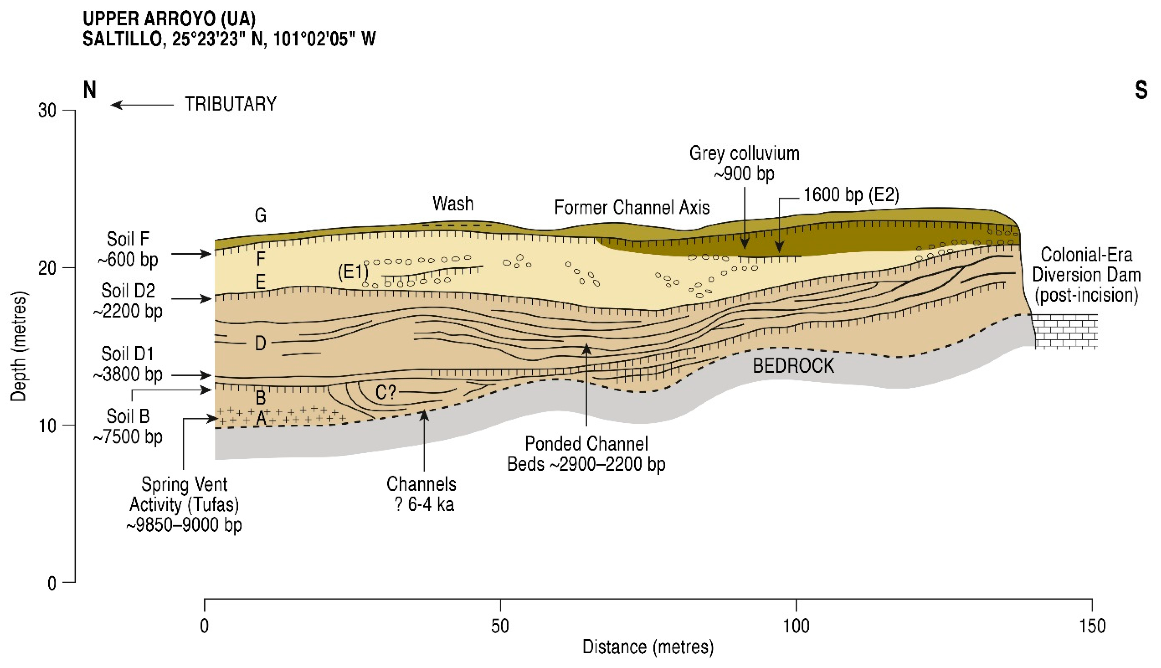
The study region comprises the Saltillo basin and valley of the Upper Arroyo, situated in the larger Chihuahuan Desert in southern Coahuila, Mexico (Figure 1 and Figure 2). The study site of Upper Arroyo (hereafter UA) is situated at an elevation of 1665 m amsl and is comprised of a 12 m-deep, 140 m-wide quarry exposure of alluvium of the Upper Arroyo drainage within Saltillo City limits first examined by Prof. Karl Butzer in the 1990s [13]. Within this deep exposure, seven major alluvial sedimentary units with multiple stratigraphic unconformities are described (Units A–G). The two exposures examined by the author include the “main unit” (25°23′23″ N, 101° 02′05″ W, 1665 m amsl), sampled to a depth of 10.45 m, and the “tributary unit” (25°23′42″ N, 101°01′58″ W, 1665 m amsl). The latter tributary, transverse to the main exposure, was sampled to a depth of 3 m (see Figure 2). It is noted that a major unconformity is evident in the main exposure between older Unit B and younger Unit D, with ephemeral expression of an intermediate depositional unit (designated Unit C). The lower (Units A, B) and upper (Units D, E, F, G) parts of the main exposure refer hereafter to this unconformity, while the tributary unit contains substantial sediments of Unit C’s age that are absent in the main exposure. Sediments in the tributary exposure are thus of intermediate age in terms of stratigraphy.
The present climate in the Saltillo study region is subtropical, with long, hot summers and short, cool winters. Precipitation occurs mainly in the summer months, with dry winters. The vegetation in the region is influenced primarily by zonal factors, such as orographic precipitation, and secondarily by azonal factors, such as physiography [14] and drainage, for example, in the Late-Holocene erosion and accumulation in the Angostura badlands, replacing a broader floodplain with deep gullies upstream of Upper Arroyo (Figure 2). According to an intensive dating program at the project site at La Angostura, major erosion and incision of the Upper Arroyo main drainage occurred in its upper reaches during the Late Holocene in particular, with a final channel incision dating to approximately 500 BP. Splays of coarse sediments are also evident in the Late Holocene, including Unit E, the “bed-load eruption phase” in the upper part of the main sequence (cf. [13]).
Important vegetation zones of the surrounding Sierra Madre Oriental highlands and circumscribing the Upper Arroyo basin include a lower limit of Pinus with mixed deciduous trees found at 2300 to 2800 m amsl, and a mixed-oak scrub of Quercus pungens, Quercus spp., Celtis spp., Acacia spp., and short-grasses, with a lower elevation limit of about 1700 m amsl. Below 1700 m amsl (upper and lower pediments), xerophytic, desert vegetation with succulents, including Opuntia spp., Euphorbiaceae, Agave spp., and Amaranthaceae, predominates (Figure 3). Upper pediments in this desert zone are also deeply incised in the La Angostura badlands upstream of Upper Arroyo. Riparian vegetation also includes a variety of taxa, including trees and shrubs, such as Fraxinus berlandieriana, Salix nigra, and Ephedra spp., as well as herbs, such as Cyperaceae and Labiatae (pers. obs. University of Texas at Austin, Herbarium, 2008).
It is important to note that the main sequence of the upper arroyo site is situated in a basin, as determined by watershed limits of about 15 square kilometers, while the basin of the tributary sequence is similar in these upper reaches, being also approximately 15 square kilometers in area. (cf. Figure 2). Both sites drain the middle and higher elevations in their hydraulic pollen catchments, including the piedmont fanglomerate zone of intermediate altitude with mixed-oak scrub woodland, as well as the higher-altitude pine woodlands on Lower Cretaceous limestone (Figure 3). The pollen spectra are derived from both floodplain vegetation, reflecting the drainage hydrology at multiple altitudes (50–90% TLP, according to fluvial analogs [7,15]), as well as regional (cf. [16]) and zonal vegetation belts, reflected in the migration of vegetation belts by altitude, esp. according to changes in orographic precipitation (<50%). Here, initial analog sampling in the Sierra Manchacas basin near Cuatrocienegas indicated strong regional and zonal (elevation) influences on surface pollen, regardless of the local flora [9], similar to the findings of a well-developed analog database produced in the Sierra Madre Occidental [17].

3. Stratigraphic Pollen Studies in Northern Mexico

Stratigraphic pollen studies of vegetation history in semi-arid northern Mexico are sparse and derive from three site types. These types include (1) desert lowland cienegas with interdigitated organic sediment and calcareous tufas [18,19,20], (2) highland peats in Sierra Madre Occidental basins with high orographic precipitation [17], and (3) slack-water-margin alluvial sites at intermediate elevations, generally between 1000 and 2000 m amsl in the Sierra Madre Oriental ([9,21,22]; classifiable as lowland sites according to Ortega [23]). The limits of these pollen investigations include problems with Holocene sedimentation, particularly at lowland cienega sites, where moisture balances become unfavorable for organic sediment accumulation with progressive aridification during the Holocene (cf. [18]). Importantly, at alluvial sites, special hydrological conditions are also required for adequate pollen deposition and preservation [10,11,12]. Here, it is important to locate non-oxidized sediments in a relatively low-energy depositional environment for the purposes of pollen analysis. These conditions also reduce the problems of the re-deposition of bulk sediment and charcoal used in radiometric dating that can be severe in high-energy alluvial environments. The use of low-order drainages was thus prioritized in these alluvial pollen studies.
It is pertinent to note with respect to alluvial sediments that flume experiments, modeled on real-world situations (including esp. the granularity of accretion surfaces), negate the importance of sorting of pollen grains by size in most alluvial situations [15]. Additionally, fluvial pollen monitoring (analog) data from the UK are notable, where 91% of pollen is deposited at the flood stage without respect to grain-size sorting via settling velocity [7]. According to these analogs, the pollen catchment is mostly limited to the drainage basin itself, with important down-drainage transport of pollen grains. Catchment at alluvial pollen sites will thus reflect the vegetation at different elevations according to the basin characteristics along the long valley profile of a given drainage.
High- and middle-elevation sites have produced major Holocene sequences from Saltillo, southern Coahuila, that are also the focus of the present study. In the important work of Ortega-Rosas [17], multiple highland sites were examined in the western parts of the Sierra Madre, and oscillations in the tree limits of different vegetation zones during the Holocene were recorded. Here, a downslope expansion of highland conifer and mesophytic woodland vegetation, including Picea and Abies, was recorded during the Early Holocene. Similarly, lower tree limits of Pinus and an expansion of mesophytic trees, such as Ulmus, at lacustrine and alluvial sites around the paleo-lake of Laguna Mayran, southern Coahuila [21,22], and at the Arroyo Grande alluvial site, Durango [9], were recorded. These sites further indicated later xeric oscillations and increased desert scrub vegetation at intermediate elevations. An expansion of desert flora was evident in at least two stages in the Middle and Late Holocene.

4. Field and Laboratory Methods

Pollen sampling took place from cleaned geological profiles of the former channel axis exposure using monolith tins upon cleaning exposures of the Upper Arroyo site (Figure 4 and Figure 5). Sediments were analyzed in the Geoarchaeology Laboratory, University of Texas at Austin, by Professor Karl Butzer and Paul Lehman (Figure 5), with the provision of particle-size analyses (by a sieve and hydrometer cylinder following loss-on-ignition [24]), loss-on-ignition (by incinerator oven), and carbonate data (through the addition of HCL) [13]. Pollen sampling employed variable sampling intervals where calcareous tufas (cf. Units A and B), oxidized sediments, and zones of large-sized particle clasts (cf. gravels of Unit E or the “Bed-load eruption phase” [13]) were avoided. Here, pollen was expected to be either deteriorated (oxidation), deposited in extremely low initial concentrations (cf. large clasts), or exceedingly difficult to process (calcareous tufas; however, see [19]). Additionally, closer-interval sampling was employed in the case of certain discrete sedimentary variability, especially in the lower part of Unit D, where finely interdigitated Chara (light in color) and reduced, organic-rich clays (dark in color) occurred. Large volumes of sediment (10 cc) were subsampled from the monolith tins and concentrated in two stages:
Stage 1: These selective pollen samples were reduced prior to chemical treatment (Stage 2) by mechanical means, involving first a pretreatment with deflocculation in a 5% sodium–hexametaphosphate solution in order to disaggregate all sediments. Initial sieving (discarding the coarse fraction) was conducted through 180µ brass screens. The samples (still in phosphate solution) were then mechanically filtrated through 8µ Nitex screens, retaining the larger fraction. This mechanical reduction was important due to the age-dependent isomorphous substitution of silicon by metal ions in desert environment clays (rendering such clay sediments resistant to HF reduction). Trial laboratory work importantly determined the significant presence of metal ions in non-pretreated samples (i.e., where no mechanical reduction of clays was attempted).
Stage 2: After cleaning in distilled water, pollen samples were chemically reduced through the application of hot 49% HF, followed by a warm 10% HCL reduction of silico-fluorides, with a pretreatment of 10% cold HCL and 10% hot KOH. At the initial (cold) HCL stage, a Lycopodium tablet of exotic fern spores, issued by the University of Lund, was added to the samples for concentration calculation. Following the above, hot acetolysis (10% sulfuric acid and 90% acetic anhydride solution) was importantly limited to less than 60 s with acetic acid [25], given the low organic contents of most samples. Excessive acetolysis might damage pollen grains in such cases. Distilled water for cleaning and ETOH for dehydration was employed. Pollen samples were finally dyed in safranin and tetra-butanol and placed in a matrix of 2000-viscosity silicone oil for the purposes of light microscopy work.
Light microscopy work was conducted at 400× magnification for scanning purposes and at 1000× magnification in immersion oil for more precise identifications using a Nikkon light microscope. Pollen counts of 200 to 600 g per sample were achieved. After counting, pollen diagrams were drawn using the TILIA program, where pollen zonation was conducted using stratigraphically constrained incremental sum of squares cluster analysis according to the percentage data, facilitated by the CONISS module also developed by Grimm [26]. The latter measured the dissimilarity of sample clusters in terms of Edwards and Cavalli-Sforza’s chord distance, which was then plotted on the right-hand-side of the pollen diagrams. A uniform chord distance was chosen in each diagram for the grouping of pollen spectra into stratigraphic zones, based upon the major brachiation patterning in the CONISS dendrogram. This refers to clusters of samples that were relatively similar (i.e., low chord distance between samples), but were relatively different (significantly higher chord distance) in the stratigraphic sequence.

5. Results

5.1. Radiometric and AMS Dating

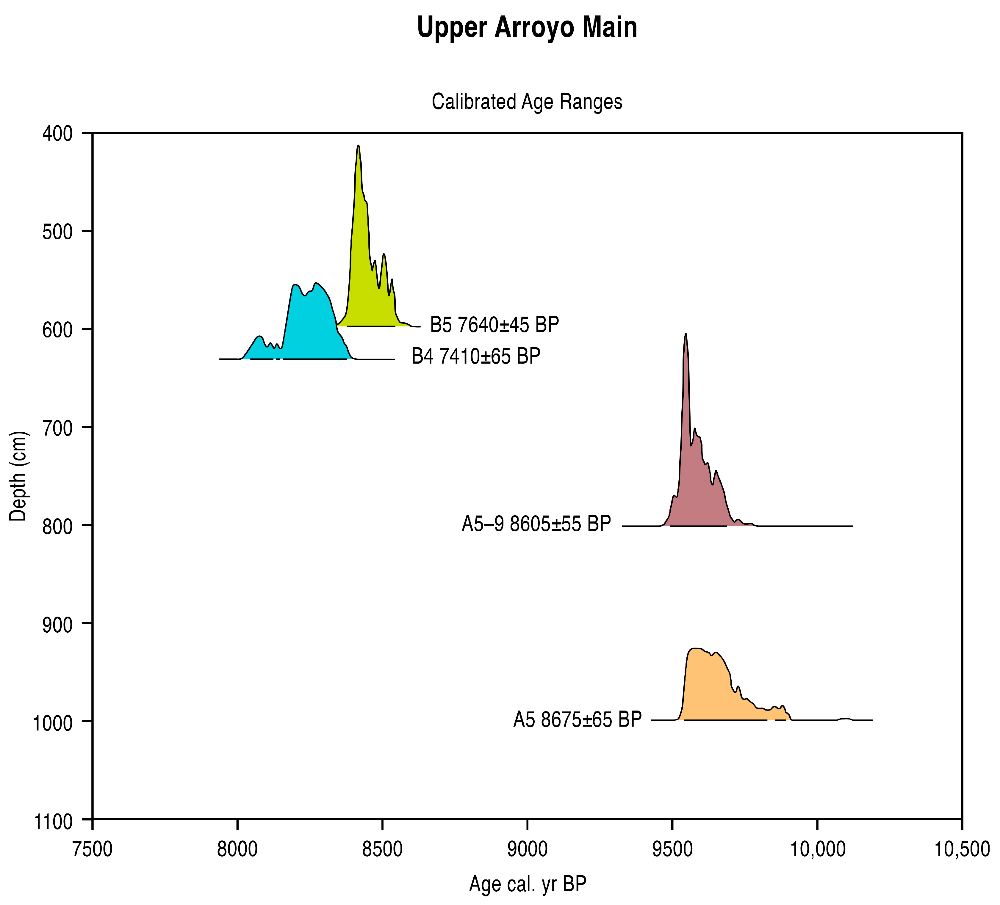
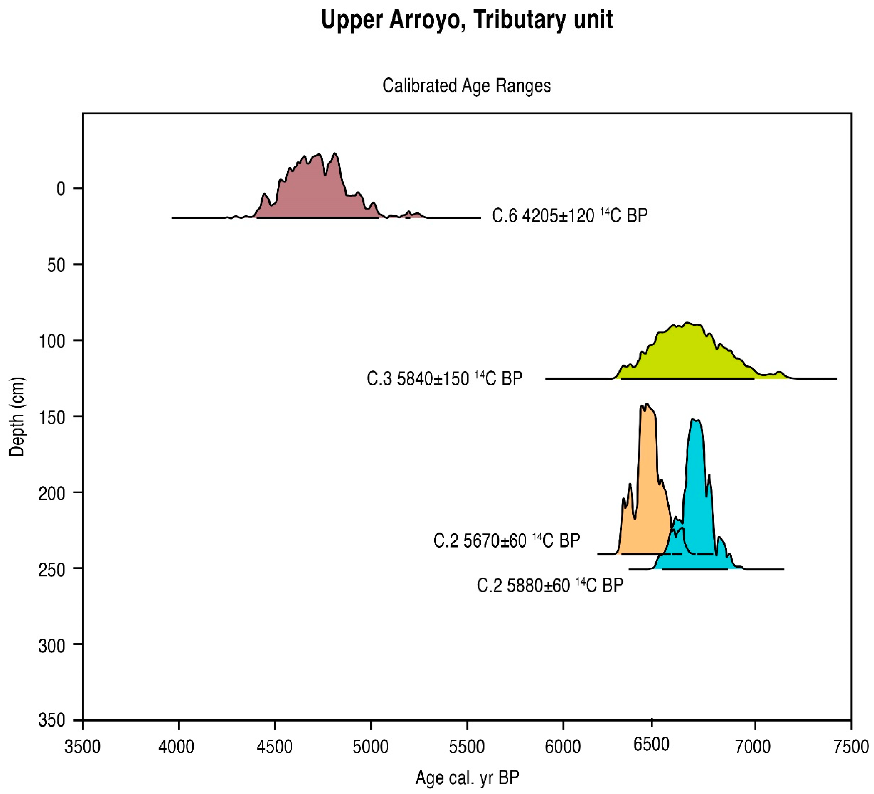
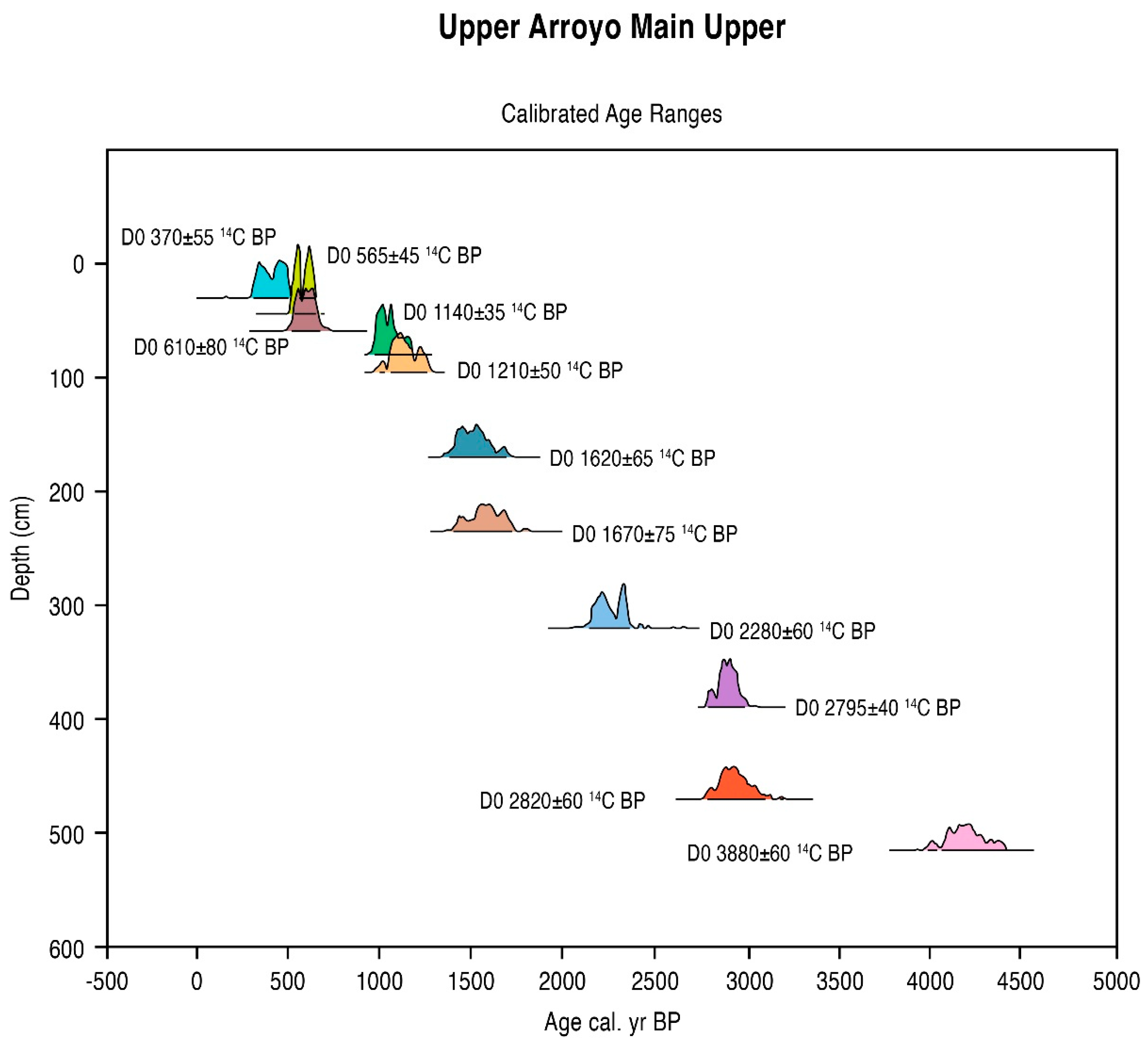
The results of 27 radiometric and AMS assays from the site of Upper Arroyo are presented below (Table 1, Table 2 and Table 3). All dates were Holocene in age and sequential with respect to general unit stratigraphy. Thus, all dates in Unit B (main sequence, see Figure 4) were older than those in the overlying or cross-cutting units (C, D, E, F, and G), all Unit C dates (tributary sequence) were older than those of Unit D, and so on. However, multiple inversions were noted within units with respect to depth (eight cases of intra-unit inversions). The latter was rejected from the linear age–depth estimate and noted below in parentheses (Lab number column). Three rejected dates from the tributary sequence and upper part of the main sequence reflected either the re-deposition of older organic materials (OS 16100, OS15413), intrusion of younger materials in poorly consolidated sediments (e.g., TX9170 in gravels), or statistical problems related to the date. In these cases, the rejected dates comprise outliers that also contradicted the results of the main series of dates. Furthermore, probable hard-water error [27] was inferred in the case of dates (OS 17058, AA 33477, AA 33478, and AA 33479; note the presence of in-situ fully aquatic plants, see Section 5.2.1. below) from the lower part of the main sequence, where profuse tufa spring deposits were encountered in situ (cf. Figure 5). A somewhat uniform difference in age as opposed to the accepted date clustered around a relative (differential) value of +1000 years in these five cases also conformed to a hard water error that would produce a consistent error factor as opposed to more variable factors of re-deposition and intrusion. Importantly, the Terminal Pleistocene pollen site of La Angostura Pond [21], upstream of Upper Arroyo, supported a younger dating of Unit B at Upper Arroyo via pollen dating, and specifically an absence of Artemisia steppe flora in the pollen diagram (Section 5.2.1). If older, rejected dates were valid, then the diagram base (Zone 1), actually composed of mesophytic woodland and wetland flora, would be expected to contain aspects of such steppe vegetation. The linear age–depth estimate here accepted the limits of multiple major hiatuses, such as the circa 5000-year hiatus in the Middle Holocene period in the main Upper Arroyo sequence (and represented in the tributary), that preclude the use of Bayesian statistics. Rather, the median calibrated age (Table 1, Table 2 and Table 3) was used for the linear calculation of age-to-depth (Figure 6, Figure 7 and Figure 8; cf. [28]). The rejection of the older date series in the Early Holocene sequence at Upper Arroyo was thus based upon four observations:
  • The presence of spring vents in situ within a limestone bedrock geology (Figure 3), giving rise to a hard-water local hydrology. Note the presence of calcareous tufas;
  • The presence of aquatic and semi-aquatic flora according to the pollen data of Zone 1 in the lower part of the main sequence (see Section 5.2.1 below) presented an ecology that would permit a hard-water error, as opposed to that of terrestrial plants;
  • An apparent, non-random error factor of circa +1000 y calculated in this part of the sequence in the rejected date series (4). A systematic error resulting from hard-water (as opposed to a re-working of old, or intrusion of young sediments) would be expected to be expressed at a relatively constant differential;
  • Pollen dating of the Terminal Pleistocene site of La Angostura at a 7 km distance from Upper Arroyo. An early dating of Upper Arroyo (i.e., an acceptance of the series of rejected dates) would place Zone 1 within the timeframe of the Artemisia steppe formation in the basin of Upper Arroyo. This vegetation unit is not apparent in the Zone 1 pollen data in the lower aspect of the Upper Arroyo sequence.

5.2. Palynological Analyses

5.2.1. Pollen Zonation and Sedimentary Interpretation of the Early Holocene Sequence

Zonation in the lower part of the main sequence employed a uniform Edwards and Cavalli-Sforza’s chord distance of eight, indicated by the major brachiation patterns of the CONISS dendrogram defining two zones (Figure 9):
Zone 1 QuercusPinusCaryaUlmus (785–1045 cm, 8875–10,000 BP). The pollen values of all tree taxa including mesophytic taxa, such as Carya (6.3% max.) and Ulmus (9.9% max.), as well as Fraxinus (8.8% max.) were high in this zone and included many absolute maxima within the woodland grouping. Unusual trees and shrubs here included trace values (less than 1%) of Ericaceae (cf. Arbutus spp.), Alnus, Betula, and Rhus. Wetland pollen also had high values and importantly included multiple submergent perennial aquatics, such as Nymphaea, Potomogeton, and Myriophyllum. Further mesophytic herbs included trace values of Labiatae (cf. Mentha) and Trifolium. Xerophytes (group) comprised only 4.6% of the TLP sum on average in this zone and included the absolute minimum of Amaranthaceae at Upper Arroyo, as a whole, of zero percent.
Zone 2 Quercus–Pinus–Amaranthaceae (530–710 cm, 7900–8860 BP). Mesophytic tree pollen, including that of Carya (zero percent throughout the zone) and Ulmus (2.3% zonal average), declined, while Amaranthaceae pollen rose significantly in this zone (to 54.4% in the ultimate sample; 38.8% zonal average). Wetland pollen (group) also declined, whereby an absence of perennial deep-water taxa was noted.
The early Holocene pollen zones of Upper Arroyo indicate wet, mesic initial climate conditions and an important presence of trees, including mesophytic taxa, such as Ulmus, Carya, and Fraxinus. The wetland pollen types include not only telmatics (Typha spp., Cyperaceae), but also perennial aquatics, such as Nymphaea and Myriophyllum. The latter taxa indicate that the channel of Upper Arroyo was submergent throughout the year to a depth one approximately one meter or more. The final pollen spectra (Zone 2, upper aspect) indicate a drying trend at the end of the Early Holocene sequence, however. The mesophytic vegetation in Zone 1 moreover conforms to the indicative values of context sedimentology, with extensive calcareous tufa formations at spring vents (a sub-aqueous indicator). The higher amount of xerophytic vegetation recorded in Zone 2 accordingly aligned with the cessation of tufa formation and (unsampled) oxidation horizons (Figure 5).

5.2.2. Pollen Zonation and Interpretation of the Mid-Holocene Sequence

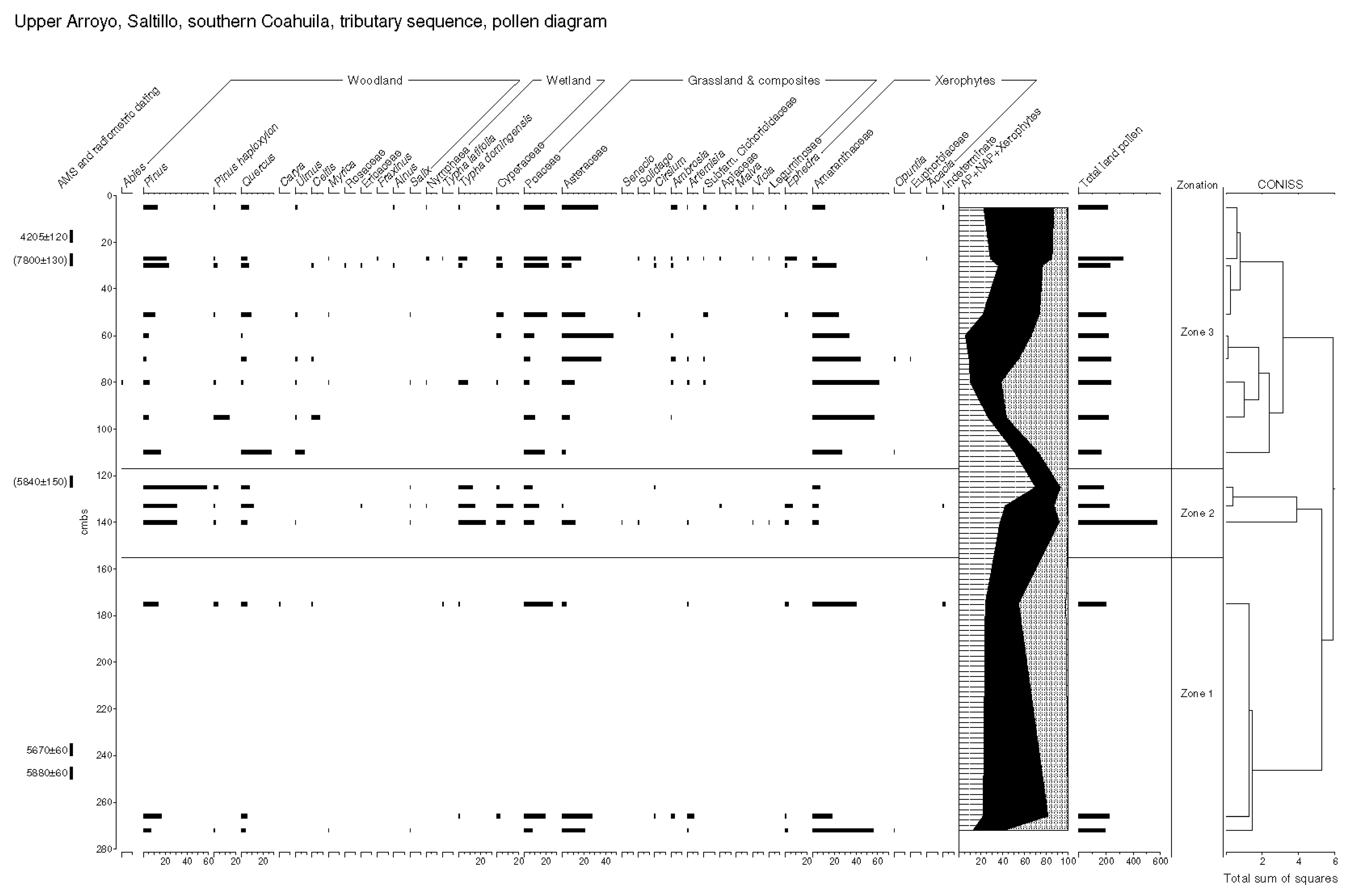
Zonation here proceeded according to a uniform Edwards and Cavalli-Sforza’s chord distance of five in the tributary sequence. Three zones were defined here (Figure 10):
Zone 1 Amaranthaceae–Asteraceae–Poaceae (175–272 cm, 6150–6900 BP). High values of Amaranthaceae (17.9-55.6%, with 38.0 % zonal average) occurred in this zone. The presence of Opuntia was noted. Low AP was also noted, including Pinus (7.1–16.5%, 12.3% zonal average) and Quercus (4.1–5.5%). An absolute maximum of Poaceae (25.9%) was finally noted.
Zone 2 Pinus–Typha domingensis (125–140 cm, 5650–5750 BP). Pinus rose to an absolute maximum (58.4%, 39.9% zonal average) in this zone. The Quercus values also remained elevated (10.9% max.). Wetland pollen rose, including Typha domingensis, which attained an absolute maximum (24.7%, 17.2% zonal average), while xerophytes were depressed, with Amaranthaceae at an absolute maximum (5.4%, 6.0% zonal average).
Zone 3 AmaranthaceaeAsteraceaePoaceae (5–80 cm, 4600–5250 BP). An absolute maximum of Amaranthaceae (61.3%) was attained in this zone. Pinus declined (to an absolute minimum of 2.6%), along with Quercus (zero percent min.) and AP generally. Typha domingensis declined (2.2% zonal average, along with wetland types generally, although a final expression of Nymphaea was noted (27 cm)).
The middle-Holocene pollen zones of Upper Arroyo indicated dry, xeric climate conditions and an important presence of saltbush (with high pollen productivity) and succulents (insect-pollinated and under-represented). Within this longer xeric period, at least one more mesic interval was identified with higher water tables, an important expression of telmatic flora, including, importantly, Typha domingensis, as well as Cyperaceae around 5700 BP. It was noted that context sedimentology also matched these phases with respect to hydrological indicative values, with the mesic phase being aligned with pond deposits and longer arid phases with coarse-grained sandy deposits that may reflect the secondary alluvial transport of originally eolian materials. A gap in sampling in Zone 1 further indicated coarse sands unsuited to pollen analysis (Subunit C2, see Figure 5). Increased erosion and accumulation reflective of reduced vegetation interception was also inferred for the Middle Holocene in the main sequence especially, based upon the fact of the long stratigraphic hiatus of approximately 4000 years here.

5.2.3. Results: Zonation and Interpretation of Late-Holocene Sequence

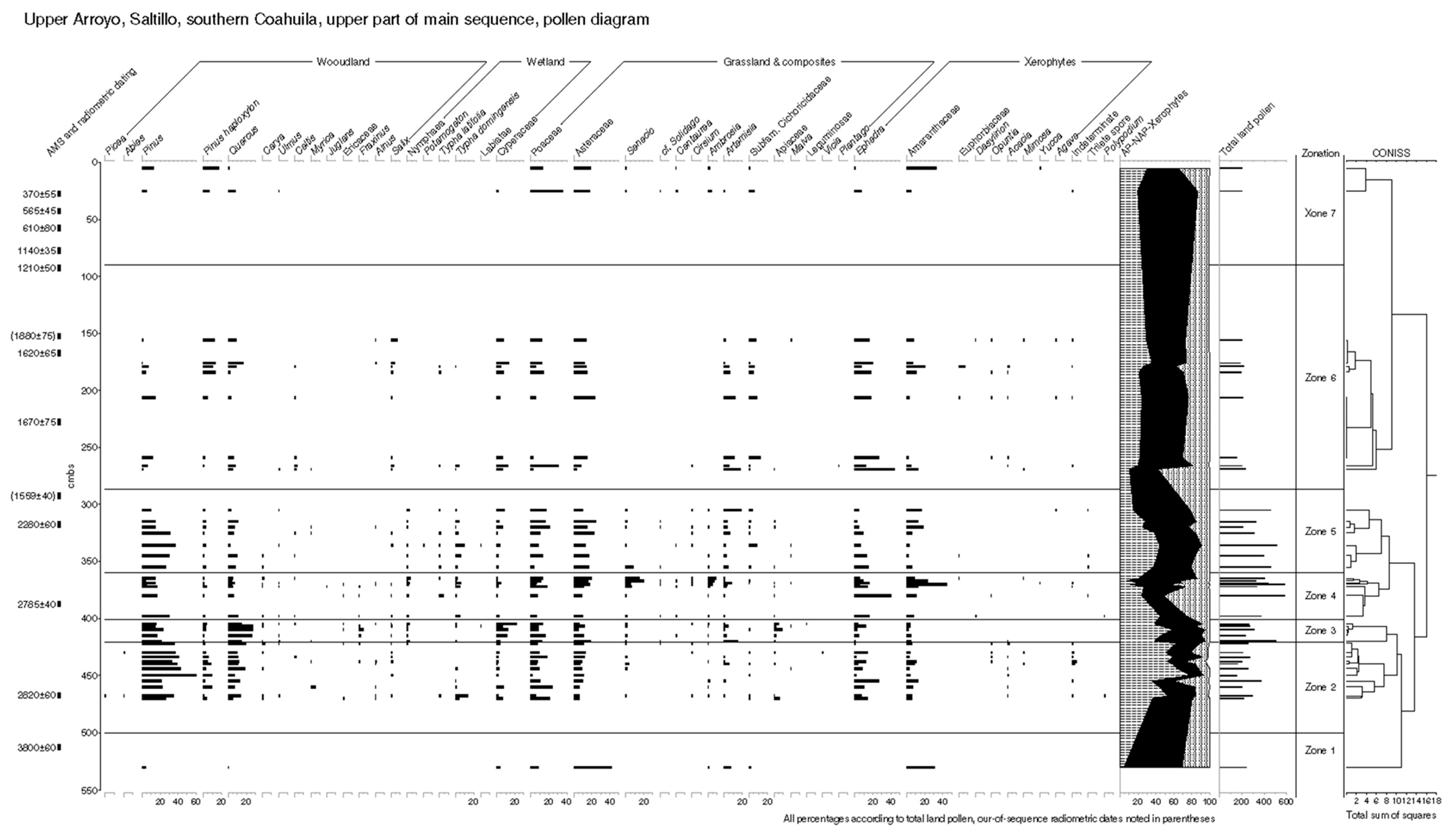
Seven zones were defined according to a uniform Edwards and Cavalli-Sforza’s chord distance of eight in the upper part of the main sequence (Figure 11):
Zone 1 AsteraceaeAmaranthaceae (510 cm, ~4190 BP). Asteraceae pollen comprised 42.4% and Amaranthaceae 30.7% in this sub-zone.
Zone 2 PinusQuercus (422–470 cm, ~2900 BP). Pinus pollen comprised an average of 35.7% in this zone, while the average Quercus values rose to 11.3%. Cyperaceae pollen averaged 2.8% in this zone, wherein nearly continuous Carya and Alnus occurred, albeit in trace values. Low pollen values of Amantrhaceae were noted.
Zone 3 QuercusPinusCyperaceae (405–420 cm, ~2800 BP). Pinus pollen comprised an average of 18.3% in this zone, while Typha domingensis attained an acute high value (5.1%, absolute maximum) in this zone, wherein nearly continuous Carya Ulmus, Alnus, and Fraxinus occurred in trace values. Low average Amantrhaceae values (3.7%) were noted.
Zone 4 EphedraAmaranthaceae (365–398 cm, 2600–2800 BP). Tree pollen declined generally, while nearly continuous Carya Ulmus, Alnus, and Fraxinus were noted in trace values. Amaranthaceae rose to an absolute maximum (44.8%), with high composite values also being expressed (Asteraceae, Senecio). Very high Ephedra values were finally noted (40.6% absolute maximum).
Zone 5 Asteraceae (305–355 cm, 2150–2600 BP). The Pinus values averaged 23.5% in this zone, wherein the Quercus curve also remained depressed. Very high composite pollen levels were noted, including Asteraceae (24.9% max.), Senecio, and Artemisia.
Zone 6 Pinus haploxylonEphedra (156–269 cm, 1450–1900 BP). Pinus haploxylon rose in this zone and attained average values of 7.0% while Pinus declined. Increased Ephedra was further noted here (44.4% absolute max.), along with sustained high Artemisia.
Zone 7 Pinus haploxylonAmaranthaceae (5–25 cm, 0–400 BP). Pinus haploxylon rose from 6.9 to 17.2% in this zone as Quercus declined (to 0.5%). A rise in Amaranthaceae from 4.5 to 32.5% was finally noted.
The late-Holocene pollen zones of Upper Arroyo finally indicated variable dry, xeric climate conditions with a mesic phase of increased tree pollen and telmatic (wetland) flora around 2800 BP. Thereafter, the conditions were uniformly xeric, with mesophytic trees, particularly Fraxinus, becoming increasingly uncommon. Pinus haploxylon partially replaced other Pinus spp. in upland zones at this time. In terms of context sedimentology, a major land erosion phase with the deposition of coarse sediments, including gravels, in Unit E (Figure 5) was bracketed by high Ephedra (see Zones 5 and 6), indicating dry, rocky ground and low-organic-content soils within the pollen catchment.

6. Discussion

6.1. Zonal vs. Azonal Floral Changes at Upper Arroyo

According to Cabellero-Rodríguez [23], specific pollen types associated with elevation zones, and thus orographic micro-climates, from Central Mexico were identified according to statistical techniques (Detrended Correspondence Analysis or DCA). From the lowland pollen sites in this region (340–1970 m amsl), the most typical pollen flora included Asteraceae and Amaranthaceae. From the middle-elevation pollen sites (2044–2330 m amsl), the typical pollen flora included Quercus and Ulmus, while, from the high-elevation sites, (2570–3860 m amsl), the typical pollen flora included Picea and Abies. These associations, as defined by DCA based on a pollen analysis of 17 sites, will be used in the general assessments of the Saltillo region’s environmental changes and, in particular, elevation changes in tree limits. Such studies have an advantage over modern analog sampling (moss pollsters and traps that are anemophilous in design) in that the taphonomy of pollen sites is more isomorphous to the current study, and in many of the cases examined by Cabellero-Rodríguez, basin sites were significantly fed by inlet channels and thus contained a major water-transport component [23].
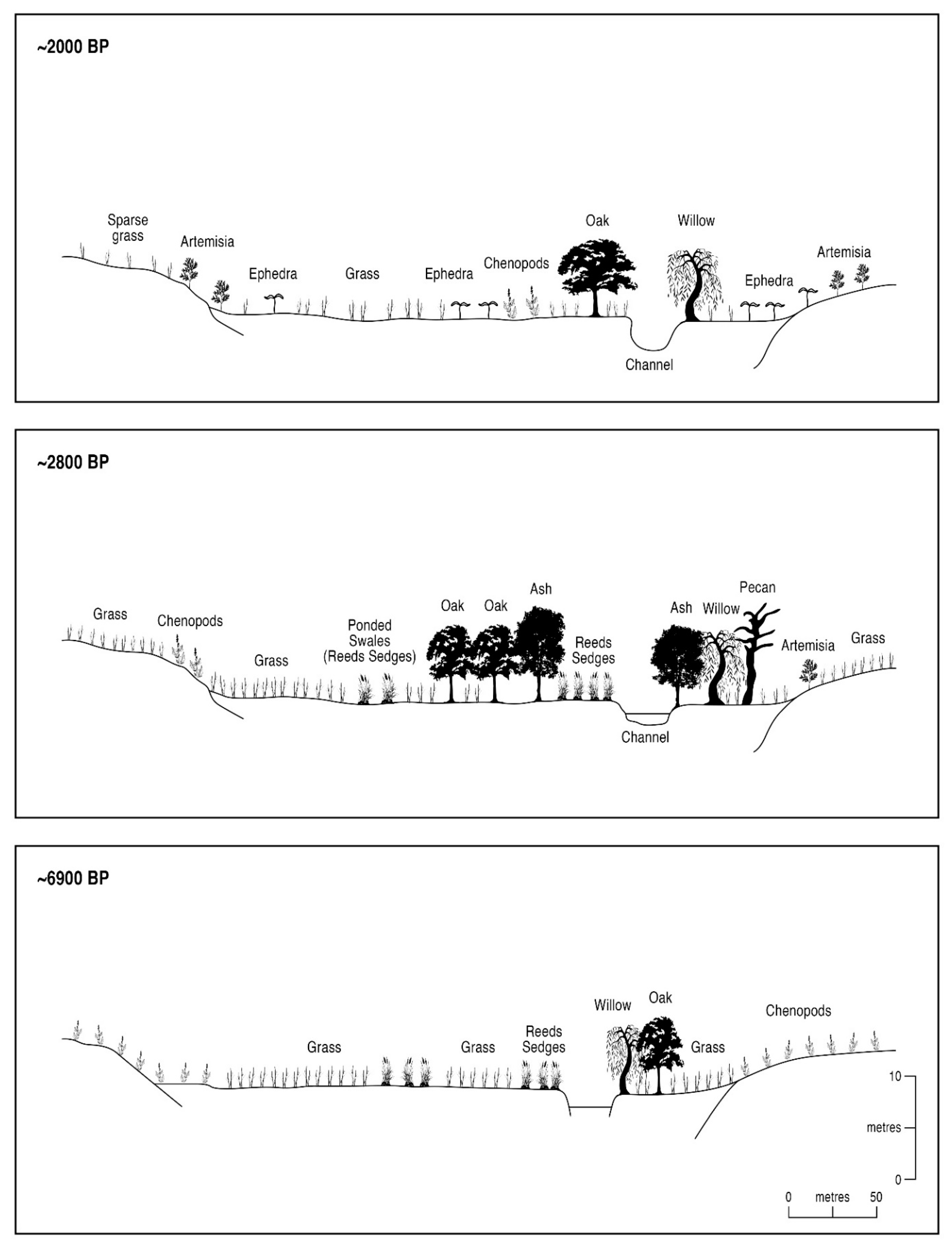
At the alluvial site of Upper Arroyo, pollen from alluvial accretion surfaces reflected a combination of such zonal vegetation belts, with over-patterning of floodplain and riparian verge flora over a 10,000-year period (Figure 12). However, in the modern pollen flora (Zone 7, upper part of the main sequence), a rise in Amaranthaceae was conditioned by the dam construction itself, which blocked the channel flow and reduced the pollen representation of upstream, non-desert elements (cf. [10] for analogous dam effects on the levels of flotational Pinus pollen). Before the Spanish Colonial dam construction, the Upper Arroyo site was subject to major upstream influences that transported pollen downstream from the upper limits of the drainage basin. Moreover, in the case of both the main and tributary basins, the land areas drained were approximately equal and cross-cut upland limestone, piedmont, and bottomland zones. Given the strong kinetic vectors of water transport, flora from the middle and upper elevations were relatively strongly represented in spite of the distance factors. A reconstruction of zonal and azonal flora in the basin of Upper Arroyo follows, based upon the pollen zonation (above) and DCA-identified vegetation communities presenting zonal eco-communities (Table 4).
According to the summary vegetation reconstruction in Table 4, the zonal and azonal vegetation patterns agreed with the climatic and hydrological indicative values at Upper Arroyo, such as the downslope migration of floral communities in tandem with the higher paleo-drainage (presently arroyo) water tables at 10,000 to 8875, 5750 to 5650, and 2900 to 2800 BP (cf. Figure 12). Furthermore, a significant pattern of secular (century-level timescale) mesic/xeric oscillations was identified, particularly where the sampling intervals were sufficiently fine (e.g., in inter-digitated Chara deposits, Unit D, main sequence). These secular oscillations, moreover, matched the indicative values of sedimentology, both in the context of sediments and in the Laguna Project database as a whole (cf. Figure 13), most emphatically in the 10,000 to 8875 BP period, when perennial aquatic flora indicated the minimum depth of the deepest parts of the Upper Arroyo channel to be at least one meter. Highly organic pond sediments indicative of ponding, as well as the formation of calcareous tufa spring vents, also indicated such water tables.
However, after a final wet period circa the 2800 BP wet phase with high tree pollen, continuous Typha domingensis in the floodplain, and in situ Chara algal sediments, no further mesic oscillations were recorded at Upper Arroyo (cf. Figure 12, 2000 BP interval). Moreover, zonation in the Late Holocene sequence was determined statistically by azonal pollen flora, with zonal vegetation belts, such as pine woodland (now containing Pinus haploxylon (cf. P. cembroides)), scrub woodland, and xerophytic vegetation being maintained in the upland, piedmont, and lowlands in relatively static zonal positions. Before considering these developments in southern Coahuila, let us first take note of the pollen and sediment records from other parts of Subtropical Mexico so as to help distinguish broader inter-regional patterns from those of a local character.

6.2. Comparative Environmental Records in North and Central Mexico

The results of the Upper Arroyo pollen analyses summarized above invite general comparisons with other environmental records from subtropical Mexico, including pollen, geochemical, and isotopic records from terrestrial paleosols. These records uniformly indicated a cyclical trend toward progressive desertification in the middle-to-late Holocene, with temporal horizons of cycles being significant at secular, century-level timescales. Desertification can be defined here in terms of low lake levels, increased erosion and accumulation in soil profiles, high levels of xerophyte pollen at lowland pollen sites, upslope migration of tree limits recorded at highland pollen sites, and enhanced carbon isotope levels in dated paleosols. Phase relationships could be identified within the limits of dating that suggest the importance of climatic changes in some records.
The geochemical records considered here began in the Santaguillo Basin in the Chihuahuan Desert, where a 3 m sediment core provided multiple proxies for hydrological change [29]. Of special interest here is Section 3, dating to 11,500 to 4000 BP, within which Early Holocene conditions of high rates of water flow into the paleo-lake site are followed by a drier period after 9000 BP. Comparable changes, expressed by vegetation, were also recorded during this period at Upper Arroyo in the lower part of the main unit, where aquatic flora with profuse woodlands were replaced by a more xerophytic flora. Importantly, mesic conditions circa 9000 BP have also been indicated in the Sierra Madre Occidental, where lower alpine limits of taxa, such as Picea and Abies, were recorded [18], with a restriction of such trees to higher altitudes in the later Holocene. The lowered position of these arboreal flora was conditioned by higher orographic precipitation at this time, conforming to both the Santaguillo site and Upper Arroyo with respect to the climatic-indicative values. It was also noted that Park, in the pollen analysis of a sediment core from Hoya San Nicholas in Central Mexico, recorded analogous ecological changes. Of interest here is the wet phase identified between 9000 to 5700 BP, according to the high Alnus pollen values, including, within this timespan, two mesic phases identified at Upper Arroyo [30]. Stable (non-erosional) conditions were also defined in the Talaxcala Block sediment site, Central Mexico, with two horizons of soil development dating to 9000 and 6000 BP [31].
Different to this Early Holocene record was that interpreted at the (endorheic) Lake Zirahuen site, which exhibited a sedimentary hiatus in the Early Holocene, indicating a drying of the lake beds. However, the later part of the hiatus was coeval with a xeric phase (before 7900 BP, Table 4) at Upper Arroyo, suggesting the possibility of a dis-conformable as opposed to an un-conformable surface under comparable conditions (cf. [32]). In other words, a phase of low lake levels might also have led to erosion and accumulation of bottom sediments at circa 8000 BP, with the erosion of sediments, rather than a strict hiatus over a longer period (note the situation of core ZIR03-1 at the erodible lake edge).
Analogous trends were also seen in the 18 m sediment core from Lake Chalco in Central Mexico, where higher levels of lacustrine vegetation in the Early Holocene were replaced by terrestrial elements in the Middle Holocene, according to the C/N ratio data, corresponding also to increased inorganic carbon, indicative of increased evaporation in the Late Holocene and thus increased water deficits [33]. From the southeastern margins of the Chihuahuan Desert, the El Potosi Basin site was also considered with respect to aridification trends after the Early Holocene. At El Potosi, lipid biomarker proxies showed a decrease in woodland and grassland flora and a tandem increase in desert scrub flora in the middle-to-late Holocene [29], similar to the indications of increased C4 desert flora in the Basin of Mexico after 5000 BP [34,35].
Alignments of inter-regional vegetation changes continued in the Late Holocene, where, at Hoya San Nicholas, aridification processes were interrupted during a mesic phase dating 2800 to 2200 BP, with high Alnus values [30]. Significantly, this was partly coeval with a final wet phase identified at Upper Arroyo (Zone 3, Late Holocene sequence), where an upper limit of Fraxinus and other mesophytic trees was recorded. The lake-level data for the late-Holocene period were generally indicative of a drying trend at that time [31,32], with potential increased sediment inputs from human land use. In northern Mexico, paleolake data for the late Holocene were lacking, with a shortage of lacustrine and predominance of eolian sedimentation in examined cores (cf. unconformable surface [36]). It is noted that secular periods of enhanced water tables were recorded during the past 2000 years at Laguna Mayran, southern Coahuila (Figure 13), aligned also with possible prehistoric horticulture of squash, according to the pollen of the Cucurbitaceae type at the site of Coahuila Highway 30, dating to circa 1500 BP [9], comparable to the 1400-to-1900 BP wet phase at Lake Zirahuen [32].

7. Conclusions

7.1. History of Desert Flora and Associated Sedimentation Processes

The earliest Holocene pollen data from Upper Arroyo, in the lower part of the main sequence, indicated a highly mesic, afforested environment where desert vegetation corresponding to the Modern typology was almost completely excluded, even in the lowland areas of the site pollen catchment, as evidenced by the very low values of even anemophilous xerophytic pollen taxa, such as Amaranthaceae. The sediment data of the period (10,000–9000 BP) also corroborated the palynology in terms of environmentally indicative values, with calcareous (spring-vent) tufas also indicating a high water table in the period before 9000 BP. Holocene development of the Chihuahuan Desert vegetation at Upper Arroyo, Saltillo, was first evidenced around 8800 BP in the lower part of the main sequence, according to the pollen evidence for the emergence of saltbush and succulents in the site’s lowlands. Importantly, eroded soil organics that accumulated in the initial (Holocene) desertification (upper part of Unit B, cf. Figure 3) attained a maximum in the 8860-to-7900 BP period. This desert vegetation continued to be the prevalent element in lowland flora during the middle Holocene, as evidenced in the tributary sequence (Figure 9), coeval with the erosion of sediments, which was intensified by lower vegetation cover, in the main sequence. The increased denudation of soils during this desertification process itself reduced their water-retention potential, beginning in the early Holocene in the Saltillo region and continuing in the middle Holocene (tributary sequence). Ultimately, this lowering of the soil moisture level influenced plant life through the promotion of high-water-use-efficiency xerophytic plant communities at different elevations. This process was accelerated particularly after 2300 BP in Upper Arroyo, according to the combined pollen and sediment data for major, high-energy erosion and accumulation events with the transport of gravels down the Upper Arroyo long profile (Unit E). Xerophytic vegetation associated with this period included many plants adapted to rocky substrates, including Ephedra.
Superimposed on this xeric trend were also wet phases associated with down-slope migrations of arboreal vegetation and higher floodplain water tables around 5700 (cf. Talaxcala Block 6000 BP soil [30]) and 2800 BP (cf. Hoya San Nicholas Alnus high [30]). Relatively mesic vegetation communities reconstructed in these periods were further associated with sediments of mesic indicative value, including a paleosol in the tributary sequence (cf. Unit C1) and Chara algal deposits (Unit D1). A late-Holocene maximum of woodland vegetation in the Upper Arroyo floodplain also occurred circa 2800 BP, including trees, such as Fraxinus and Carya, and herbaceous vegetation, including semi-aquatic taxa, such as Typha (Figure 12). Significantly, these wet phases at Upper Arroyo are well-aligned with both the regional Laguna Project environmental record until about 2300 BP (Figure 1 and Figure 13) and inter-regional records (6.2 above). Remarkably, however, the carbon isotope data recorded none of the above changes, possibly due to the over-representation of riparian verge tree and herb taxa (all C4 photosynthetic pathway flora?) during the entirety of the Holocene (cf. Table 1, Table 2 and Table 3, column 5 data).

7.2. Causes of Desertification—Climatic and Physiographic Factors

The alignments of the pollen and (sediment-based) hydrology reconstructions before 2300 BP suggested an important agency of global factors, such as climate changes, in forcing the expansion of desert vegetation. These factors included increased severity of droughts and reduced summer precipitation. In terms of the specific agency of xeric climate phases, these may also have been aligned with annual ENSO events in North Mexico [37]. Most of the emphatic xeric development appeared to date to the middle Holocene (8000–4000 BP, with a mesic interval defined at 5700 BP) and, finally, after 2300 BP. Both floodplain and zonal (elevation belt) vegetation responded in tandem to these changes, with deforestation in mountain regions and a lowering of the water table in the Upper Arroyo floodplain.
However, differences between the Upper Arroyo pollen with the general Laguna Project hydrological record were observed after 2300 BP (cf. Figure 13). In this period, xerophytes and composites comprised the pollen record, and mesophytic taxa, such as Carya and Fraxinus, no longer appeared. Indeed, telmatic floodplain taxa, such as Typha, were replaced by dry ground herbs, such as Ephedra, although regional; the Laguna Mayran lake level included multiple wet phases in the Late Holocene (Figure 1 and Figure 13), also associated with telmatic herbs at the limnic margins of this intermittent lake [21,22]. From this pattern, it was inferred that a much smaller proportion of seasonal precipitation was available for local flora in the Upper Arroyo floodplain in the Late Holocene, although non-evapotranspired rainfall modulated the lake levels at Laguna Mayran. Most likely, this was the result of physiographic factors, such as erosion and incision, which reduced hydration and water retention in soils. Indeed, from the main sequence sedimentary profile, intense erosion and accumulation or “bed-load eruption” was indicated by the gravels accumulated in Unit E (after 2300 BP). Similarly, xeric environmental changes were also noted around 2000 BP at Lake Chalco, Tlaxcala (Central Mexico), where agricultural impacts on land erosion and lake sedimentary fills were significant [31].

7.3. Azonal Desertification Processes and Endemism of Upland Flora

The phylogenetic development of the Chihuahuan Desert flora in relation to desertification processes was finally considered in light of the Upper Arroyo data. As noted initially (see Section 1 above), an unusual diversity of species, and particularly upland flora of the mixed-oak scrub, is present on arid land in Mexico today. This diversity requires the establishment of (xeric) micro-environments, as well as mechanisms preventing species migration. In this work, processes of azonal, xeric niche development were reconstructed according to pollen and sediment data, as well as a zonal mechanism (desert expansion) for the geographic isolation of azonal mountain and drainage niches. It is useful also to consider the case of one widespread tree species in Mexican uplands, pinyon pine, or Pinus edulis, which is also definable in regional palynology (P. haploxylon-type) and whose expansion is specifically promoted by azonal physiographic conditions. Thus, during the post-2300 BP period, significant changes in upland flora recorded at Upper Arroyo included a partial replacement of undifferentiated pine species with pinyon pine or the Pinus haploxylon type. This replacement is indicative of an increasing importance of azonal factors in vegetation development, given the importance of slope (41% of variation) and aspect (59% of variation) in the present distribution of P. edulis [37].
The importance of land erosion upstream of the Upper Arroyo site, in the La Angostura badlands, needs to also be considered in the identification of erosional episodes. In these badlands, erosion has altered the slope aspect in part along the long valley profile (cf. Figure 3), and valley incision upstream leads to mass accumulation downstream. These coarse sediments with poor water retention (cf. Upper Arroyo Unit E) also limit the development of mesophytic trees and shrubs, thus resulting in a tendency for the replacement of Fraxinus with riparian verge taxa, such as Salix (cf. Figure 12). In temporal terms, major erosion was defined after 2300 BP at Upper Arroyo itself and also circa 500 BP at La Angostura, at the watershed of Upper Arroyo [21]. Importantly, the latter erosion phase corresponds to the 1454 drought reconstructed in North Mexico, according to (Taxodium) tree-ring data [38], and indicates the continued importance of climate change as a contributing factor in desertification processes.
The vegetation patterns reconstructed at the Upper Arroyo pollen site in the Late Holocene are thus suggestive of the increasing importance of local physiographic in addition to climatic processes in the development of the Chihuahuan desert flora. These physiographic factors include the denudation of the soil organic content, the reduction in the hydration of floodplain soils, and the establishment of xerophytic ecological niches. The latter niches include steepening slope parameters and soil erosion in piedmont and highland zones on a local basis, enhancing the competitiveness of tree species that grow on steep, rocky substrates, such as Pinus edulis, as well as a wide range of desert succulents on floodplains ([1,2], cf. Figure 3 and Figure 12). Significantly, there is no evidence for the importance of human land use as a major factor in vegetation development before modern times in southern Coahuila, with only localized horticulture being evident during prehistory [22]. Indeed, the Chihuahuan Desert’s formation began eight millennia before the Spanish Colonial period in northeastern Mexico.
As the formation of the Chihuahuan Desert vegetation took place in a variegated geography incorporating both zonal and azonal aspects, the high level of species diversity of the middle-slope mixed-oak scrub flora in the Chihuahuan Desert [1,2] can also be explained, as endemism of species is encouraged by the isolation of flora in localized ecological niches. Here, endemism is influenced by geological processes that produce xeric micro-environments on mountain slopes and drainages, as well as the climatic factors that led to the initial expansion of the halophytic lowlands (cf. periodic high Amaranthaceae values post-8800 BP, Section 7.1 and Section 7.2). These lowlands exclude xeric scrub, the rhizomes of which are unable to exert sufficient osmotic pressure for the transpiration of salt water. Over Pleistocene timescales, the periodic expansion of desert vegetation further erected barriers to species migration between mountain ranges that formed ‘islands’ of endemism in the Sierra Madre. This geographic isolation finally promoted a high level of species diversity of the mixed-oak scrub flora within North Mexico as a whole.

Funding

Texas Higher Education Coordinating Board, Austin, Texas Grant no. 003658-473.

Data Availability Statement

Not applicable.

Acknowledgments

The late Karl W. Butzer of the Department of Geography and Environment, University of Texas at Austin, Austin, Texas, USA, and the Texas Higher Education Coordinating Board are acknowledged for their support of the pollen analyses. Additionally, the assistance of Jim Innes and Christ Orton (Cartographic Unit) in the drawing of figures by the Department of Geography, Durham University, DH1 3LE, UK, is acknowledged.

Conflicts of Interest

The author declares no conflict of interest.

References

  1. Sosa, V.; De-Nova, J.A.; Vásquez-Cruz, M. Evolutionary history of the flora of Mexico: Dry forests cradles and museums of endemism. J. Syst. Evol. 2018, 56, 523–536. [Google Scholar] [CrossRef]
  2. de León, R.M.; Castellanos-Morales, G.; Moreno-Letelier, A. Incipient speciation, high genetic diversity, and ecological divergence in the alligator bark juniper suggest complex demographic changes during the Pleistocene. Peerj 2022, 10, e13802. [Google Scholar] [CrossRef] [PubMed]
  3. Buxbaum, C.A.Z.; Vanderbilt, K. Soil heterogeneity and the distribution of desert and steppe plant species across a desert-grassland ecotone. J. Arid. Environ. 2007, 69, 617–632. [Google Scholar] [CrossRef]
  4. Wainwright, J.; Parsons, A.J.; Abrahams, A.D. Plot-scale studies of vegetation, overland flow and erosion interactions: Case studies from Arizona and New Mexico. Hydrol. Process. 2000, 14, 2921–2943. [Google Scholar] [CrossRef]
  5. Li, J.; Okin, G.S.; Alvarez, L.; Epstein, H. Quantitative effects of vegetation cover on wind erosion and soil nutrient loss in a desert grassland of southern New Mexico, USA. Biogeochemistry 2007, 85, 317–332. [Google Scholar] [CrossRef]
  6. Castro-López, V.; Domínguez-Vázquez, G.; Islebe, G.A.; Priego-Santander, A.G.; Velázquez, A. Modern pollen-vegetation relationships across a landscape mosaic in central México. Rev. Palaeobot. Palynol. 2021, 289, 104362. [Google Scholar] [CrossRef]
  7. Brown, A.G.; Carpenter, R.G.; Walling, D.E. Monitoring fluvial pollen transport, its relationship to catchment vegetation and implications for palaeoenvironmental studies. Rev. Palaeobot. Palynol. 2007, 147, 60–76. [Google Scholar] [CrossRef]
  8. Liu, D.; Ma, J.; Wu, P.; Pan, Y. A new indicator for dividing sedimentary rhythms in alluvial deposits: A pollen-based method. Catena 2020, 189, 104500. [Google Scholar] [CrossRef]
  9. Albert, B.M. Holocene aridification, vegetation change, sedimentation regime and limits of carbon isotope data as indicated by the alluvial pollen sites of Arroyo Grande and El Molino in North-Central Mexico. Quat. Int. 2015, 377, 2–17. [Google Scholar] [CrossRef]
  10. Albert, B.M. Acidification and Pine Expansion in East Texas According to Pollen Evidence from Dual Cores in Alluvium. Castanea 2011, 76, 164–177. [Google Scholar] [CrossRef]
  11. Albert, B.; Innes, J.; Krementskiy, K.; Millard, A.R.; Gaydarska, B.; Nebbia, M.; Chapman, J. What was the ecological impact of a Trypillia megasite occupation? Multi-proxy palaeo-environmental investigations at Nebelivka, Ukraine. Veg. Hist. Archaeobot. 2019, 29, 15–34. [Google Scholar] [CrossRef]
  12. Albert, B.; Pokorný, P. Pollen Taphonomy and Hydrology at Vranský potok versus Zahájí Alluvial Pollen sites: Methodological Implications for Cultural Landscape Reconstruction in the Peruc Sandstone Area, Czech Republic. Interdiscip. Archaeol.—Nat. Sci. Archaeol. 2012, III, 85–101. [Google Scholar] [CrossRef]
  13. Butzer, K.W.; Abbott, J.T.; Frederick, C.D.; Lehman, P.H.; Cordova, C.E.; Oswald, J.F. Soil-geomorphology and “wet” cycles in the Holocene record of North-Central Mexico. Geomorphology 2008, 101, 237–277. [Google Scholar] [CrossRef]
  14. Muller, C.H. Plants as Indicators of Climate in Northeast Mexico. Am. Midl. Nat. 1937, 18, 986. [Google Scholar] [CrossRef]
  15. Holmes, P.L. Differential transport of spores and pollen: A laboratory study. Rev. Palaeobot. Palynol. 1990, 64, 289–296. [Google Scholar] [CrossRef]
  16. Jacobsen, G.L.; Bradshaw, R.H. The selection of sites for palaeoecological studies. Quat. Res. 1981, 16, 80–96. [Google Scholar] [CrossRef]
  17. Ortega-Rosas, C.I.; Peñalba, M.C.; Guiot, J. Holocene altitudinal shifts in vegetation belts and environmental changes in the Sierra Madre Occidental, Northwestern Mexico, based on modern and fossil pollen data. Rev. Palaeobot. Palynol. 2008, 151, 1–20. [Google Scholar] [CrossRef]
  18. Meyer, E.R. Late-Quarternary Paleoecology of the Cuatro Cienegas Basin, Coahuila, Mexico. Ecology 1973, 54, 982–995. [Google Scholar] [CrossRef]
  19. Felstead, N.J.; Gonzalez, S.; Huddart, D.; Noble, S.R.; Hoffmann, D.L.; Metcalfe, S.E.; Leng, M.J.; Albert, B.M.; Pike, A.W.; Gonzalez-Gonzalez, A.; et al. Holocene-aged human footprints from the Cuatrociénegas Basin, NE Mexico. J. Archaeol. Sci. 2014, 42, 250–259. [Google Scholar] [CrossRef]
  20. Ortega-Rosas, C.I.; Peñalba, M.C.; Guiot, J. The Lateglacial interstadial at the southeastern limit of the Sonoran Desert, Mexico: Vegetation and climate reconstruction based on pollen sequences from Ciénega San Marcial and comparison with the subrecent record. Boreas 2016, 45, 773–789. [Google Scholar] [CrossRef]
  21. Albert, B.M. Past vegetation influence on the hydrological cycle in the Chihuahuan Desert, North Mexico as indicated by data of four pollen sites. Quat. Int. 2015, 374, 168–181. [Google Scholar] [CrossRef]
  22. Albert, B.M. Prehistoric and Colonial land-use in the Chihuahuan Desert as inferred from pollen and sedimentary data from Coahuila, Mexico. Quat. Int. 2015, 377, 38–51. [Google Scholar] [CrossRef]
  23. Caballero-Rodríguez, D.; Correa-Metrio, A.; Lozano-García, S.; Sosa-Nájera, S.; Ortega, B.; Sanchez-Dzib, Y.; Aguirre-Navarro, K.; Sandoval-Montaño, A. Late-Quaternary spatiotemporal dynamics of vegetation in Central Mexico. Rev. Palaeobot. Palynol. 2018, 250, 44–52. [Google Scholar] [CrossRef]
  24. Ashworth, J.; Keyes, D.; Kirk, R.; Lessard, R. Standard Procedure in the Hydrometer Method For Particle Size Analysis. Commun. Soil Sci. Plant Anal. 2001, 32, 633–642. [Google Scholar] [CrossRef]
  25. Faegri, K.; Kaland, P.E.; Krzywinski, K. Textbook of Pollen Analysis, 4th ed.; John Wiley & Sons Ltd.: Chichester, UK, 1989. [Google Scholar]
  26. Grimm, E.C. CONISS: A FORTRAN 77 program for stratigraphically constrained cluster analysis by the method of incremental sum of squares. Comput. Geosci. 1987, 13, 13–35. [Google Scholar] [CrossRef]
  27. England, J.; Dyke, A.S.; Coulthard, R.D.; Mcneely, R.; Aitken, A. The exaggerated radiocarbon age of deposit-feeding molluscs in calcareous environments. Boreas 2012, 42, 362–373. [Google Scholar] [CrossRef]
  28. Trachsel, M.; Telford, R.J. All age–Depth models are wrong, but are getting better. Holocene 2017, 27, 860–869. [Google Scholar] [CrossRef]
  29. Chávez-Lara, C.M.; Holtvoeth, J.; Roy, P.D.; Pancost, R.D. 27cal ka biomarker-based record of ecosystem changes from lacustrine sediments of the Chihuahua Desert of Mexico. Quat. Sci. Rev. 2018, 191, 132–143. [Google Scholar] [CrossRef]
  30. Park, J.; Byrne, R.; Böhnel, H.; Garza, R.M.; Conserva, M. Holocene climate change and human impact, central Mexico: A record based on maar lake pollen and sediment chemistry. Quat. Sci. Rev. 2010, 29, 618–632. [Google Scholar] [CrossRef]
  31. Sycheva, S.A.; Pogosyan, L.; Sedov, S.; Solleiro-Rebolledo, E.; Golyeva, A.A.; Barceinas-Cruz, H.; Abrosimov, K.N.; Romanenko, K.A. Evidence for stages of landscape evolution in Central Mexico during the late Quaternary from paleosol-pedosediment sequences. Quat. Res. 2022, 107, 159–177. [Google Scholar] [CrossRef]
  32. Ortega, B.; Vázquez, G.; Caballero, M.; Israde, I.; Lozano-García, S.; Schaaf, P.; Torres, E. Late Pleistocene: Holocene record of environmental changes in Lake Zirahuen, Central Mexico. J. Paleolimnol. 2010, 44, 745–760. [Google Scholar] [CrossRef]
  33. Ortega-Guerrero, B.; Lozano-García, S.; Herrera-Hernández, D.; Caballero, M.; Beramendi-Orosco, L.; Bernal, J.P.; Torres-Rodríguez, E.; Avendaño-Villeda, D. Lithostratigraphy and physical properties of lacustrine sediments of the last ca. 150 kyr from Chalco basin, central México. J. S. Am. Earth Sci. 2017, 79, 507–524. [Google Scholar] [CrossRef]
  34. Lamb, A.L.; Gonzalez, S.; Huddart, D.; Metcalfe, S.E.; Vane, C.H.; Pike, A.W. Tepexpan Palaeoindian site, Basin of Mexico: Multi-proxy evidence for environmental change during the late Pleistocene–Late Holocene. Quat. Sci. Rev. 2009, 28, 2000–2016. [Google Scholar] [CrossRef]
  35. Nobel, P.S. Physicochemical and Environmental Plant Physiology, 4th ed.; Academic Press: New York, NY, USA, 2005. [Google Scholar]
  36. Roy, P.D.; Jonathan, M.P.; Pérez-Cruz, L.L.; Sánchez-Córdova, M.M.; Quiroz-Jiménez, J.D.; Romero, F.M. A millennial-scale L ate Pleistocene–Holocene palaeoclimatic record from the western Chihuahua Desert, Mexico. Boreas 2012, 41, 707–718. [Google Scholar] [CrossRef]
  37. Romero-Manzanares, A.; Flores-Flores, J.L.; Luna-Cavazos, M.; Garcìa-Moya, E. Effect of Slope and Aspect on the Associated Flora of Pinyon Pines in Central Mexico. Southwest. Nat. 2012, 57, 452–456. [Google Scholar] [CrossRef]
  38. Stahle, D.W.; Cook, E.R.; Burnette, D.J.; Villanueva, J.; Cerano, J.; Burns, J.N.; Griffin, D.; Cook, B.I.; Acuña, R.; Torbenson, M.C.; et al. The Mexican Drought Atlas: Tree-ring reconstructions of the soil moisture balance during the late pre-Hispanic, colonial, and modern eras. Quat. Sci. Rev. 2016, 149, 34–60. [Google Scholar] [CrossRef] [Green Version]
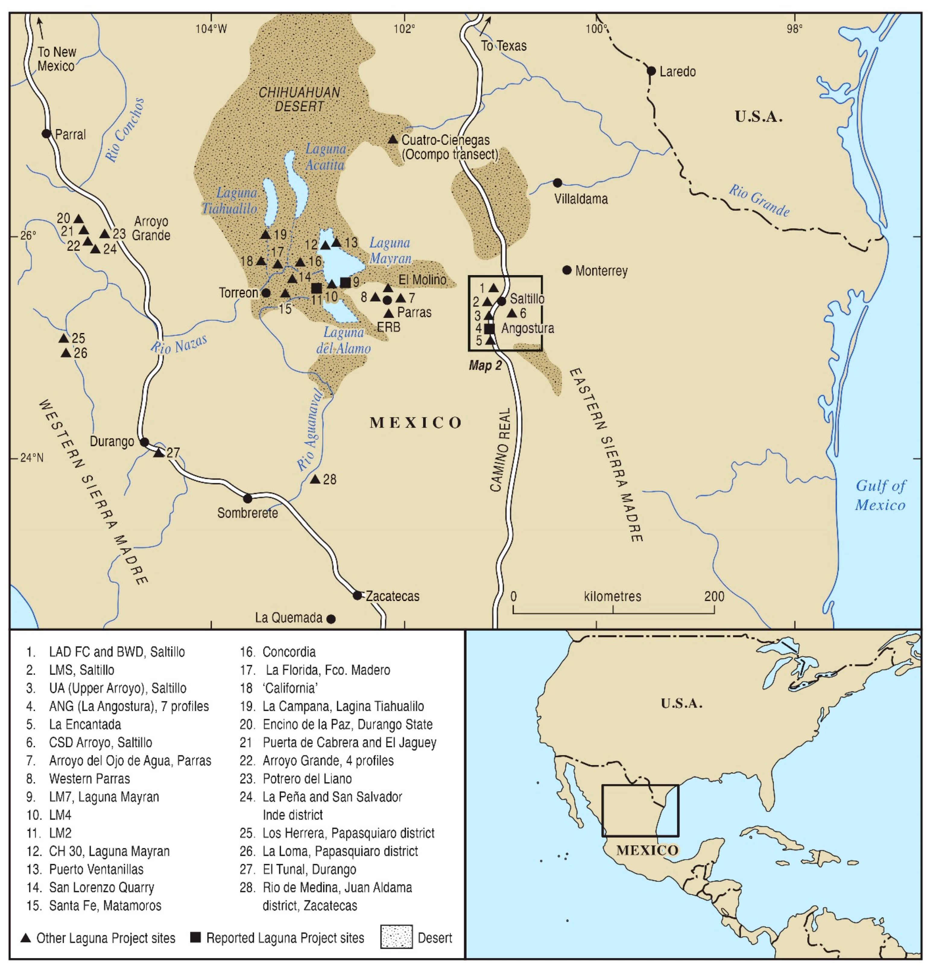
Figure 1. Laguna Project sites (40), northeastern Mexico. These are Upper Arroyo pollen and fluvial; the geomorphic site is indicated (Site 3) within the rectangular inset. These forty sites represent the totality of the geomorphological and botanical data contributing to the cumulative dataset for wet–dry cycles during the last 13,000 years Site 4 (La Angostura) is also mentioned in the main text.
Quaternary 06 00015 g001
Figure 2. Saltillo region, southern Coahuila, Upper Arroyo site, with the main and tributary drainages indicated (modified from [13]).
Quaternary 06 00015 g002
Figure 3. Long valley profile of the Upper Arroyo basin cross-cutting the bottom, piedmont, and highland zones; transect from the Upper Arroyo site to the southwestern corner of Figure 2.
Quaternary 06 00015 g003
Figure 4. Upper Arroyo main exposure, general stratigraphy, and dating (modified from [13]).
Quaternary 06 00015 g004
Figure 5. Upper Arroyo (UA) sedimentology with loss-on-ignition, carbonate, magnetic susceptibility (χ) data, and location of radiocarbon and AMS dates. Note the high χ values (red highlight) for the period of Spanish Colonial dam construction, indicating eolian sediments and high CCE values (blue highlight) in calcareous tufa and Chara algal layers in the main UA sequence (modified from [13]).
Quaternary 06 00015 g005
Figure 6. Age–depth graph with the 2-Sigma plot for Upper Arroyo main sequence, lower part.
Quaternary 06 00015 g006
Figure 7. Age-depth graph with the 2-Sigma plot for the Upper Arroyo tributary sequence.
Quaternary 06 00015 g007
Figure 8. Age–depth graph with the 2-Sigma plot for the Upper Arroyo main sequence, upper part.
Quaternary 06 00015 g008
Figure 9. Relative pollen diagram for the Upper Arroyo main sequence, lower part.
Quaternary 06 00015 g009
Figure 10. Relative pollen diagram, Upper Arroyo tributary sequence.
Quaternary 06 00015 g010
Figure 11. Relative pollen diagram of the Upper Arroyo main sequence, upper part.
Quaternary 06 00015 g011
Figure 12. Reconstruction of Upper Arroyo floodplain vegetation in three Holocene intervals.
Quaternary 06 00015 g012
Figure 13. Holocene wet cycles according to the Laguna Project sedimentology data of all examined sites; see Figure 1 (modified from [13]).
Quaternary 06 00015 g013
Table 1. Upper Arroyo. Main unit, lower part, radiocarbon, and AMS dates (rejected dates in parentheses). Reprinted/adapted with permission from Ref. [13], 2008, Karl Butzer.
Unit and Depth14C AgeCal. AgeMedian AgeDelta 13CLab NumberMaterial
B5-595 cm7640 ± 458520–83608440 cal. BP−22.1AA 40612Humus (soil)
B4-630 cm7410 ± 658370–81508250 cal. BP−12.1OS 17841Charcoal
B3-800 cm8990 ± 6010,250–10,11010,160 cal. BP−24.0(OS 17058)Charcoal
B2-880 cm8820 ± 11010,180–95709890 cal. BP−23.1(AA 33477)Charcoal
A6-920 cm9065 ± 8010,430–10,12010,230 cal. BP−24.0(AA 33478)Charcoal
A6-940 cm9240 ± 5010,550–10,26010,410 cal. BP−24.1(OS 15416)Charcoal
A6-960 cm9100 ± 7510,510–10,15010,270 cal. BP−23.7(AA 33479)Charcoal
A5-9800 cm8605 ± 559680–94809570 cal. BP−22.8AA 40251Humus (soil)
A5-1000 cm8675 ± 659830–95309640 cal. BP−24.0AA 33480Charcoal
Table 2. Upper Arroyo, Tributary unit, radiocarbon, and AMS dates (rejected dates in parentheses). Reprinted/adapted with permission from Ref. [13], 2008, Karl Butzer.
Unit and Depth14C AgeCal. AgeMedian AgeDelta 13CLab NumberMaterial
C.6-20 cm4205 ± 1205060–44004740 cal. BP−19.3A 11128Humus (soil)
C.6-30 cm7600 ± 130”8660–81508410 cal. BP−18.8(OS 16100)Charcoal
C.3-125 cm5840 ± 1507030–63306660 cal. BP−24.5A 11122Charcoal
C.2-240 cm5670 ± 606570–63106700 cal. BP−24.6OS 14143Humus (soil)
C.2-250 cm5880 ± 606860–65406700 cal. BP−24.6OS 14143Charcoal
Table 3. Upper Arroyo. Main unit, upper part, radiocarbon, and AMS dates (rejected dates in parentheses). Reprinted/adapted with permission from Ref. [13], 2008, Karl Butzer.
Unit and Depth14C AgeCal. AgeMedian AgeDelta 13CLab NumberMaterial
G1-30 cm370 ± 55510–310420 cal. BP−25.3AA 33471Charcoal
G1-45 cm565 ± 45650–520590 cal. BP−24.9OS 15517Charcoal
F2-60 cm610 ± 80710–510610 cal. BP−23.5A 11116Humus (soil)
F2-80 cm1140 ± 351160–9701040 cal. BP−25.1OS 15412Charcoal
F2-95 cm1210 ± 501240–10301140 cal. BP−22.6TX 9153Humus (soil)
F1-155 cm1880 ± 751990–16801820 cal. BP−24.0(0S 15413)Charcoal
E5-170 cm1620 ± 651660–13701520 cal. BP−24.3A 11117Humus (soil)
E5-235 cm1670 ± 751760–14101580 cal. BP−24.9A 11118Humus (soil)
E.1-295 cm1550 ± 401530–13601440 cal. BP−23.9(TX 9170)Humus (soil)
D11-320 cm2280 ± 602410–21302300 cal. BP−23.1TX 9150Humus (soil)
D5-390 cm2795± 403000–28202900 cal. BP−25.2AA 40250Humus (soil)
D3-470 cm2820 ± 603110–28102940 cal. BP−24.3TX 9154Humus (soil)
DO-515 cm3800 ± 604370–40104190 cal. BP−17.9TX 9151Humus (soil)
Table 4. Zonal and azonal vegetation changes in the Holocene at Upper Arroyo.
Y. BPZonal Vegetation ElementsAzonal Vegetation Elements
10,000–8875Mixed-oak mesophytic woodland in lowlands and piedmont, and downslope migration of pine from uplandsPerennial aquatics in the channel, and ash and elm in floodplain
8860–7900Xerophytes in lowlands, mixed-oak scrub woodland in piedmont, and pine uplandsDry floodplain with ash and elm at riparian verges
6900–6150Xerophytes in lowlands and piedmont (mixed with scrub woodland), and pine uplandsDry floodplain with grasses and forbs
5750–5650Xerophytes in lowlands, mixed-oak scrub woodland in piedmont, and downslope migration of pineTelmatic-influenced floodplain with cattails
5250–4600Xerophytes in lowlands and piedmont (mixed with scrub woodland), and pine uplandsDry floodplain with grasses and forbs, minor telmatics influence
~4190Xerophytes in lowlands and piedmont (mixed with scrub woodland), and pine uplandsDry floodplain with composites
~2900Mixed-oak scrub woodland in lowlands and piedmont, and downslope migration of pineMinor telmatics in dry floodplain with alder and pecan
~2800Mixed-oak scrub woodland in lowlands and piedmont, and pine uplandsTelmatic-influenced floodplain with ash and elm at riparian verges
2800–2600Xerophytes emergent in lowlands, mixed-oak scrub woodland in piedmont, and pine uplandsDry floodplain with ash, elm, and pecan, and extensive Ephedra
2600–2150Xerophytes in lowlands, mixed-oak scrub woodland in piedmont, and pine uplandsDry floodplain with composites
1900–1450Xerophytes with Artemisia in lowlands, mixed-oak scrub woodland in piedmont, and pinyon pine uplandsExtensive Ephedra on gravels and dry floodplain
400–0Xerophytes in lowlands, mixed-oak scrub woodland in piedmont, and pinyon pine uplandsDry channel (Spanish Colonial dam construction)
Disclaimer/Publisher’s Note: The statements, opinions and data contained in all publications are solely those of the individual author(s) and contributor(s) and not of MDPI and/or the editor(s). MDPI and/or the editor(s) disclaim responsibility for any injury to people or property resulting from any ideas, methods, instructions or products referred to in the content.