Article

New Diatom and Sedimentary Data Confirm the Existence of the Northern Paleo-Outlet from Lake Ladoga to the Baltic Sea

by
Anna V. Ludikova
1,*,
Dmitry A. Subetto
2,
Denis D. Kuznetsov
1,
Alexander V. Orlov
2 and
Angelina E. Shatalova
2
1
Institute of Limnology of the Russian Academy of Sciences, St. Petersburg Federal Research Center of the Russian Academy of Sciences, 9 Sevastyanova, 196105 St. Petersburg, Russia
2
Faculty of Geography, Herzen State Pedagogical University of Russia, 48 Moika, 191186 St. Petersburg, Russia
*
Author to whom correspondence should be addressed.
Quaternary 2024, 7(3), 31; https://doi.org/10.3390/quat7030031 (registering DOI)
Submission received: 1 February 2024 / Revised: 1 July 2024 / Accepted: 12 July 2024 / Published: 19 July 2024

Abstract

:
Despite more than 100 years of research, a number of questions concerning the evolution of the post-glacial connection between Lake Ladoga, the largest European lake, and the Baltic Sea remain unanswered. In particular, the location and chronological frames of the paleo-outlet from Lake Ladoga in the Holocene remain debatable. Paleolimnological studies were performed in small lakes in the northern part of the Karelian Isthmus (NW Russia), where the outlet from Lake Ladoga, the Heinjoki Strait, is thought to have existed until the lake drained to the south due to the tilting of its basin. The presence of the indicative “Ladoga species” (e.g., Aulacoseira islandica, Achnanthes joursacense, Cymbella sinuata, Ellerbeckia arenaria, Navicula aboensis, N. jaernefeltii, N. jentzschii, etc.) in the diatom assemblages is used as evidence for the influence of Lake Ladoga during the accumulation of coarse-grained sediments at the bottom of the ancient channel. It also confirms the functioning of the hypothetical northern local branch of the strait. Decreased abundances of the “Ladoga species” and the onset of the accumulation of fine-grained sediments suggest that the water discharge via this paleo-outlet rapidly reduced starting from ca. 4100 cal BP. The termination of the functioning of the Heinjoki Strait is recorded as an abrupt disappearance of the indicative taxa from the diatom record. This was dated to ca. 3500–3200 cal BP, which corresponds to the estimated ages of the birth of the River Neva, the present outlet from Lake Ladoga.

1. Introduction

The re-routing of lake outlets resulting from the differential glacio-isostatic uplift of a lake basin is a phenomenon that has occurred in the regions in the Northern Hemisphere glaciated during the Last Glacial Maximum, e.g., in the Great Lakes region in North America, Sweden, Finland, and NW Russia [1,2,3,4,5,6,7,8,9,10,11]. For instance, several outlet shifts in lateglacial times are known for Lake Onega, the second largest lake in European Russia [12], while nine of the largest lakes in Finland have shifted their outlets at least once [9].
Lake shorelines depend on the level of the lake’s outlet. Thus, if the lake outlet is located in a faster-uplifting area, the remote parts of the lake basin will experience continuous transgression [13]. The overflow of the water mass will proceed until the lower threshold is reached, and the formation of a new outlet will terminate the transgression. The outlet shifts, in turn, result in watershed relocations and small lakes shifting from one catchment to another [14,15]. Moreover, small relic lakes that occupied the depressions at the bottom of the paleo-outlet channels may preserve sediment records of the transition from flowing to lentic environments that can be used in reconstructions of changes in the hydrographic network.
Lake Ladoga in NW Russia (Figure 1A), the largest European lake (surface area: 18.3 km2; max depth: 230 m; water volume: 847.8 m3) [16], also provides a clear illustration of changing outlet position due to tilting of the lake basin. Lake Ladoga presently drains to the Baltic Sea via the River Neva, which flows along the southern rim of the Karelian Isthmus, a strip of land between these two large waterbodies (Figure 1B). However, according to the prevailing hypothesis [3,17,18,19,20,21], this has not always been so, and the location and flow direction of the watercourse connecting Lake Ladoga and the Baltic basin have changed over time.
Following the deglaciation of its basin ca. 14,000–12,500 cal BP (calibrated years before present), the depression of Lake Ladoga was occupied by the waters of a huge proglacial lake, the Baltic Ice Lake (BIL), which formed in the Baltic basin. Fed by large amounts of meltwater, the BIL was dammed by the retreating ice sheet so that its level exceeded the global sea level by at least 25 m. Lake Ladoga received waters from the BIL via the northern and southern lowlands of the Karelian Isthmus, where, in fact, only the central highland remained unsubmerged [24]. The rapid drainage of the BIL, ca. 11,700–11,600 cal BP, and regional-scale water-level lowering resulted in the isolation of Lake Ladoga and a shrinking of its surface area [25]. There is a lack of evidence to prove whether Lake Ladoga turned into a closed basin or had an outlet to the Baltic Sea during the following short-lived connection between the Baltic basin and the ocean, the Yoldia Sea stage [24]. As the transgressing freshwater Ancylus Lake appeared in the Baltic basin ca. 10,700 cal BP, the Baltic–Ladoga connection was re-established via a broad strait in the northern part of the Karelian Isthmus. Lake Ladoga thus became integrated into the Ancylus basin as its easternmost bay [3,26]. After the Ancylus Lake regression ca. 10,200 cal BP, Lake Ladoga started to drain to the Baltic Sea via the so-called Heinjoki Strait in the northern lowland of the Karelian Isthmus, where exposed crystalline bedrocks formed the Ladoga sill (here and after, the Heinjoki threshold, present elevation ca. 15.4 m above the sea level (a.s.l.); Figure 1B,C).
The Ladoga basin, which extends over 200 km from north to south, was directly affected by differential isostatic uplift. The faster rise of its northern part led to the north–south tilting of the basin and forced Ladoga waters to transgress southward [3]. Thus, the southern coastal lowlands of Lake Ladoga, where the uplift had faded by the second half of the Holocene, experienced gradual inundation that lasted for ca. 2000 yrs and resulted in a water-level rise of at least ca. 10 m above the present. On the northern shores of Lake Ladoga and in the north of the Karelian Isthmus, the ancient shorelines of this Mid-Holocene transgression are presently traced at ca. 20 m a.s.l. [4]. As the Ladoga waters expanded further to the south–west, they downcut their way to the Gulf of Finland through the lateglacial deposits in the present Neva Lowland, the southern part of the Karelian Isthmus [3,19,21]. The drainage thus shifted from the northern outlet, i.e., the Heinjoki Strait, to the southern one, the new-born River Neva (Figure 1B), ca. 3400–3300 cal BP [27,28]. The Lake Ladoga level subsequently lowered down to its present 5 m a.s.l., while the Heinjoki Strait ceased to exist.
Although the northern outlet is believed to have functioned for thousands of years, the channel of the Heinjoki Strait is not easily traced currently. It is explained by the specifics of the local geology, which represents a patchwork of crystalline bedrock outcrops, glacial, glacial–lacustrine and fluvioglacial deposits [29] with different resistances to erosion. This should have formed a rather complex configuration of the Heinjoki Strait (Figure 1E), as shown by Ailio [30], who first mapped the paleoshorelines of the Mid-Holocene Lake Ladoga transgression. Currently, the area in the northern part of the Karelian Isthmus is characterized by a network of “relic” small lakes and connecting watercourses, probably inherited from the past outlet system of Lake Ladoga.
Previous studies of small lakes at the ancient outlet channel near the Heinjoki threshold (Figure 1C,E) revealed diatom evidence for the Ladoga–Baltic water connection at least in the second half of the Holocene [22,23]. However, 14C dating of bulk organic sediment samples yielded a wide range of ages, including age inversions. Thus, the chronology of the Ladoga paleo-outlet’s functioning and termination remained uncertain. Two local branches of the strait, the southern and northern ones, and consequently two thresholds, were already suggested in the early 1900s [30]. Field measurements of the depth and width of the dried parts of these branches performed in the early 2000s enabled the calculation of the water discharge via the Heinjoki Strait. The calculations revealed that the quantitative parameters of the Heinjoki paleo-outlet, i.e., water discharge, annual flow volume, etc., corresponded to those of the present River Neva when the water level in the Heinjoki Strait was >20 m [24]. It was also estimated that the southern branch of the strait should have stopped carrying the Ladoga waters to the Baltic Sea earlier than the northern one.
While previously studied small lakes belonged to the southern branch [22], the present study is focused on the lakes that trace the hypothetical northern one. The aim of the study is to (1) find additional bio- and lithostratigraphic evidence for the Ladoga–Baltic connection via the Heinjoki Strait, with a special focus on the compositional changes in the diatom assemblages, (2) confirm the functioning of its hypothetical northern branch, and (3) establish the chronological frame of the termination of the Ladoga–Baltic connection. For this, we applied the modified isolation basins approach using the indicative “Lake Ladoga” diatom species to infer the transition from the environments influenced by the Ladoga waters to small, isolated lake conditions. Therefore, this study is also aimed at demonstrating the potential of using diatoms in reconstructing shifts in lake outlets. The organic matter content, estimated as loss-on-ignition, was used as an independent proxy for the transition from high-energy lotic environments to standing waters with autochthonous organic sedimentation. The chronological frame for the reconstructions was provided by the AMS 14C dating of the sediment samples.

Methodological Background

The northern part of the Karelian Isthmus is a key area to study the past Ladoga–Baltic connection. Apart from traditionally applied geological and geomorphological observations, paleolimnological studies provide independent evidence for transformations of the hydrographic network in late- and postglacial times. In the Karelian Isthmus and the Ladoga region, a modified isolation basins approach is widely used to reconstruct the shoreline displacement of Lake Ladoga and the Baltic paleobasins [23,31,32,33,34].
Classical isolation basin studies are performed in small lake basins along the marine coasts that were previously below sea level and emerged subsequently due to eustatic, isostatic, or neotectonic processes. The sediment archives of those small lakes have proven to preserve litho- and biostratigraphic records of the transition from marine to lacustrine environments. The shoreline retreat below the elevation of the lake’s threshold results in the lake’s isolation and can be recognized and dated using the sedimentary isolation contacts, e.g., the transition to organic sedimentation and shifts in the diatom assemblages’ composition.
However, many small lakes experienced the transgressions of larger freshwater basins. For instance, in the Baltic region, large-scale freshwater transgressions took place in late- and early postglacial times (i.e., BIL and Ancylus Lake high-level stages). The Mid-Holocene transgression of Lake Ladoga is also known to have inundated vast coastal lowlands. As a large freshwater basin regresses, small “relic” lakes similarly form in emerged coastal depressions. The sediment archives of these lakes are thus expected to preserve litho- and biostratigraphic records of isolations other than those related to salinity changes. Sedimentation changes caused by the transition from large-lake to small-lake conditions mainly reflect a reduction in the catchment area and a decrease in allochthonous matter supply. Thus, autochthonous sedimentation prevails at the “small-lake” stage, and more organic-rich sediments accumulate. Certain biotic changes also occur. Apart from decreasing water depth, aquatic biota is especially sensitive to shifts in physical and chemical parameters (e.g., water circulation and transparency, pH, nutrient supply), habitat availability, etc., that accompany the transition from large- to small-lake environments [35].
The diatoms (Bacillariophyceae: microscopic algae with silicified cell walls that preserve well in the sediments) are often used in isolation basin studies to reconstruct the transition from a large freshwater basin to a small one. For instance, diatom studies of the Ancylus Lake sediments revealed a group of species indicative of the freshwater Ancylus transgression in the Baltic basin (e.g., [36,37]). The presence of these species can thus be used to attribute the sediments to the Ancylus Lake stage, while their disappearance from the record indicates establishing small-lake conditions after the isolation. In the Karelian Isthmus, the discoveries of the “Ancylus species” in the diatom records from small lakes were used to specify the local spatial and temporal frames of this freshwater stage of the Baltic Sea [32,34,38,39,40].
In the Lake Ladoga region, diatom studies of the sediments accumulated during the Mid-Holocene Lake Ladoga transgression also revealed a specific group of indicative species that occurred in the diatom record of the transgression and subsequently disappeared as the Ladoga waters regressed [41]. These indicative “Ladoga species”, or “large-lake species” in [27], are typical of the Lake Ladoga diatom assemblages that occurred throughout the Holocene. During the large-lake stage in a small basin, the “Ladoga species” may prevail or be overdominated by “small-lake” or indifferent taxa (i.e., able to thrive both in large and small lakes), which depends on the influence of the Ladoga waters related to the distance from the coast, local topography, etc. The isolation from Lake Ladoga results in a transition to diatom assemblages where “small-lake” or indifferent species predominate. In the present study, we use the indicative potential of diatoms to reveal additional evidence for the functioning Lake Ladoga paleo-outlet and the termination of the Ladoga–Baltic connection.

2. Materials and Methods

Paleolimnological studies of the small lakes tracing the hypothetical northern branch of the Heinjoki Strait in the northern Karelian Isthmus (Figure 1C,E) were carried out in July 2020. The sediment cores were retrieved from five lakes at 14 to 16 m a.s.l. The generalized sediment stratigraphies for all five lakes and some dating results were previously published in [42]. Here, we present the detailed diatom stratigraphies for two lakes, Hameenlampi and Lunnoe, which are separated by the Ladoga–Baltic divide and presently belong to different catchment basins (Lake Ladoga and the Baltic Sea, respectively). Both lakes are located at 14 m a.s.l. (the elevations are derived from a topographic map, where they are given with an error of ca. ±0.5 m). The elevation of the threshold within the northern branch of the Heinjoki Strait, i.e., the part of the Ladoga–Baltic divide separating the lakes Hameenlampi and Lunnoe, is above 15 m and below 20 m a.s.l., according to the topographic map.
Lake Hameenlampi (60°47.6142′ N, 29°9.4668′ E; Figure 1C,D1) has an elongated shape (ca. 660 × 210 m), and its measured depths are 2–2.5 m. Separate large boulders emerge from the lake, while their groups form several small islands (Figure 2A). Lake Hameenlampi is fed by a short stream flowing from Lake Maloe Makarovskoe in the north–west and drains via the lakes Partizanskoe and Makarovskoe in the east and south–east of Lake Ladoga.
Lake Lunnoe (60°48.52554′ N, 29°7.5846′ E; Figure 1C,D2), ca. 210 × 260 m, is a small boreal lake with a complex configuration. Large boulders rise above the lake’s surface (Figure 2B), and a rather big island is located in the central part of the lake. Exposed crystalline bedrock and boulders were also observed in the lake’s surroundings (Figure 2C). Quaking bogs develop locally along the lake’s coasts. Lake Lunnoe’s inlet and outlet are small, artificially modified streams. It drains to Lake Bolshoe Graduevskoe in the west and finally to the Baltic Sea.
Sediment coring was performed using a Russian-type peat corer from a floating platform in Lake Hameenlampi and from the surface of a quaking peat bog adjacent to the northwestern coast of Lake Lunnoe. In both lakes, coring was performed at several coring sites (3 in Lake Hameenlampi and 4 in Lake Lunnoe; Figure 1D) to trace the lithostratigaphic consistency. A detailed lithological description was subsequently formulated to define the main stratigraphic units and select sub-sampling intervals for loss-on-ignition (LOI) and diatom analyses and radiocarbon dating.
The samples for the LOI analysis were collected every 2 cm. The samples for the diatom analysis were collected every 4 cm from clays and every 2 cm from sand and gyttja, except for its upper part, which was analyzed discontinuously.
The LOI and diatom analyses were performed at the Institute of Limnology, Russian Academy of Sciences. The standard procedure was applied to estimate ignition losses. It included drying powdered samples at 105 °C for 2 h, cooling to room temperature, weighing, and ignition at 550 °C for 6 h. After subsequent cooling to room temperature, the weighing of the sample was repeated to calculate weight losses after ignition [24].
The diatom analysis was performed using the standard procedure, which involves the oxidation of organic matter with 30% hydrogen peroxide, H2O2 [43]. Clay particles were removed using repeated decantation. The subsequent separation of fractions was performed using heavy liquid Cd2J + KJ (with a specific density of 2.6 g cm−3) for mineral sediments. After repeated washing in distilled water, the residual material was diluted with a measured amount of water and stirred carefully. Then, a 0.1 mL drop of the suspension was placed on a, 18 × 18 mm cover glass, allowed to dry, and mounted on a slide using the synthetic resin “Elyashev’s medium” (refractive index n = 1.67–1.68). Diatom counts were performed until at least 500 valves. In the samples that turned out very poor in diatoms (i.e., clays and, partly, sands), counting stopped after the examination of 10 parallel transects, regardless of whether an amount of 500 valves was achieved or not. Diatom identification followed [44,45,46,47]. The “Lake Ladoga species” were grouped together according to [27,41], the others being considered “small-lake” or indifferent species. The diatom valve concentration per g of dry sediment was calculated according to the method outlined in [43]. The diatom diagram was drawn using the paleoecological software C2, Version 1.7 [48].
Age determinations were based on 14C accelerator mass spectrometry (AMS). For both lakes, ca. 0.5 cm of organic sediment in a series of sediment cores was collected from the bottommost parts of clay gyttja and/or gyttja to date the onset of organic sedimentation, which we considered a signal of the cessation of outlet functioning. At Lake Lunnoe’s core, plant macrofossils from sand were used to date fluvial environments. Radiocarbon AMS dating was performed at the laboratory of radiocarbon dating and electronic microscopy, Institute of Geography RAS (Russia), and the Center for Applied Isotope Studies, University of Georgia (USA) [42]. The dates were calibrated in the OxCal 4.4 program using the IntCal 20 calibration curve [49,50]. We use the calibrated ages (cal BP) expressed with 95% confidence limits.

3. Results

3.1. Age and Lithology
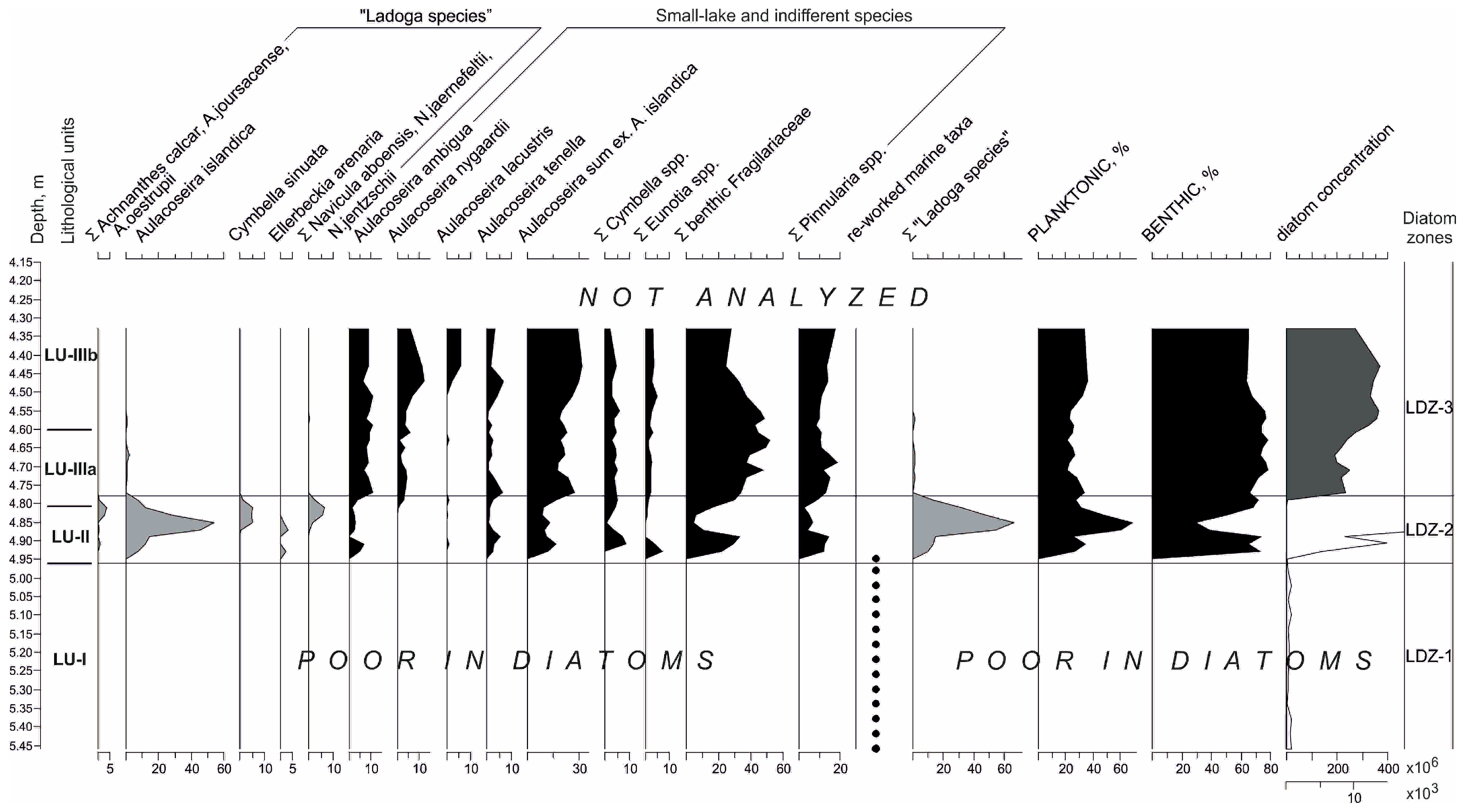
Eleven radiocarbon AMS dates were obtained from the six sediment cores from both lakes. Dated plant macrofossils from the sands in Lake Lunnoe yielded extraordinarily young ages, suggesting contamination with younger material during the coring, and they were rejected from further discussion. The dates are summarized in Table 1.
Four lithological units (LUs) were described in the sediment records of lakes Hameenlampi and Lunnoe (Table 2). The lowermost LU-I in both lakes is represented by massive or indistinctly laminated dense gray clay with low LOI values (0.4–3.0%; Figure 3 and Figure 4B).
The overlaying LU-II (0.09–0.15 m thick in Lake Hameenlampi and 0.04–0.13 m thick in Lake Lunnoe) consists of poorly sorted sands with gravel and has sharp lower and upper contacts (Figure 3 and Figure 4B,C). The LOI values are <1% (Lake Hameenlampi) and <1.5% (Lake Lunnoe). In Lake Hameenlampi, LU-IIIa is represented by gray to brown-gray clayey gyttja (up to 0.2 m, mean LOI value: 19%) with a gradual transition to ca. 1.2 m thick dark-brown gyttja (LU-IVb; LOI to 40%). At coring site 1, however, dark-brown gyttja (LU-IVb) directly overlays sands (LU-II; Figure 3 and Figure 4A). In Lake Lunnoe, all coring sites had similar stratigraphy, with sands overlaid by homogenous dark-brown gyttja (LU-III, mean LOI: 46%), transferring upwards to 1 m thick poorly decomposed peat (LU-IV). The lithological description is summarized in Table 2.

3.2. Diatoms

Three local diatom assemblages zones (LDZs) were visually recognized in the diatom records of the lakes Hameenlampi and Lunnoe.
Lake Hameenlampi. In LDZ-1 (5.5–4.96 m, LU-I), only sporadic diatom valves and their fragments were observed (Figure 5). Planktonic Aulacoseira islandica is the most commonly found freshwater species. Re-worked marine and brackish marine diatoms also occur and include resting spores of planktonic Chaetoceros spp., Thalassionema nitzschioides, and littoral Paralia sulcata, Grammatophora oceanica, and Rhabdonema spp. Diatom concentrations are very low (<1 × 10³ valves in g−1 dry sediment).
In LDZ-2 (4.96–4.78 m, LU-II–lower LU-IIIa), diatom concentrations rise from 5.3 × 10³ to 460 × 103 g−1 dry sediment. “Ladoga species” dominate in the diatom assemblages (max 66%). Among those, planktonic Aulacoseira islandica prevails (>50%), while less abundant taxa include benthic Achnanthes joursacense, Cymbella sinuata, Ellerbeckia arenaria, Navicula aboensis, N. jentzschii, etc. (Figure 5; Table 3). Other numerous species include planktonic Aulacoseira ambigua and A. subarctica, which can thrive in both large and small lakes, and “small-lake” Pinnularia spp.
LDZ-3 (4.78–4.30 m, upper LU-IIIa–LU-IIIb) is characterized by drastically increased diatom concentrations (200 × 106–360 × 106 g−1 dry sediment). “Small-lake” and indifferent taxa predominate (e.g., planktonic Aulacoseira ambigua, A. perglabra, A. nygaardii, and benthic Fragilariaceae and Pinnularia spp.). The “Ladoga species” drops down to trace amounts and subsequently disappears from the record (Figure 5).
Lake Lunnoe. In LDZ-1 (2.0–1.47 m, LU-I), rare valves and valve fragments of freshwater planktonic Aulacoseira islandica and re-worked marine and brackish marine diatoms (resting spores of Chaetoceros spp., Thalassionema nitzschioides, Thalassiosira spp., Grammatophora oceanica, and Rhabdonema spp.) were observed (Figure 6), the latter at some levels were even more frequent than freshwater ones. The diatom concentrations are very low (0.24 × 10³ to 10.4 × 10³ in g−1 dry sediment).
LDZ-2 (1.47–1.33 m, LU-II + lower LU-III) is characterized by increased diatom concentrations (223 × 103 to 1.2 × 10⁶ in sand to >460 × 106 in the lower gyttja). Benthic freshwater species dominate in the diatom assemblages (to 80%), with small-celled Fragilariaceae (max. 43%) and Pinnularia spp. being the most abundant (Figure 5). In the interval of 1.47–1.43 m, corresponding to LU-II, the species typical of Lake Ladoga diatom assemblages (e.g., Achnanthes calcar, Aulacoseira islandica, Cymbella sinuata, Navicula aboensis, N. jaernefeltii, N. jentzschii, Stephanodiscus neoastraea) occur in the record (to 11–17%). Above 1.41 m (lower LU-III), their abundance drops to trace amounts (1% and less).
In LDZ-3 (1.33–1.05 m, upper LU-III), diatom concentrations are high in the lower part of LDZ-3 (to 320 × 106) decreasing to 54 × 106 in the upper part (Figure 5). “Ladoga species” were not observed in the diatom record, while the “small-lake” and indifferent species (e.g., Aulacoseira alpigena, A. lacustris, A. lirata, A. valida, etc.) rapidly increase in abundance to 85%. In the upper part of LDZ-3, a shift to benthic predominance is observed due to an increase in Eunotia spp. (to 80%).

4. Discussion

Dense and massive or indistinctly laminated gray clays (LU-I) were uncovered in the basal parts of the sediment sequences in both lakes, Hameenlampi and Lunnoe, as well as in the nearby small lakes located on the bottom of the hypothetical northern branch of the Heinjoki Strait [42]. Extremely low diatom concentrations and a mixture of freshwater and marine species in LU-I (LDZ-1 in both lakes) are characteristic of the glaciolacustrine clays that accumulated during the BIL stage [43]. These clays are typical lateglacial sediments in the Ladoga region, including Lake Ladoga itself. Their numerous occurrences in various sedimentary archives (boreholes, outcrops, and lake sediment sequences) enable the spatial frames of the BIL to be reconstructed. In the northern part of the Karelian Isthmus, glaciolacustrine clays are commonly found at the base of the sediment sequences in small lakes located below 16 m a.s.l. [51]. In the Neva Lowland, the south of the Karelian Isthmus, they are mainly exposed in coastal outcrops and uncovered in quarries [19,52]. BIL clays are typically poor in diatoms, which points to unfavorable conditions for the growth of these microalgae (due to nutrient limitation, low water transparency, etc.) and the accumulation of their valves (due to high sediment supply to the lake). The presence of ecologically incompatible freshwater and marine species is common for BIL sediments in the study region, and the re-deposition of marine diatoms from Eemian marine sediments is widely acknowledged ([43] and references therein). The marine taxa sporadically observed in our diatom records are typical of the marine deposits of the Eemian Interglacial [53,54].
Glaciolacustrine clays in our study lakes abruptly change to coarse-grained sediments (LU-II), similar to the other small lakes located in the ancient channel of the northern branch of the Heinjoki Strait [42]. This stratigraphic unconformity between LU-I and LU-II points to some dramatic erosional event and suggests the partial removal of previously accumulated sediments. The presence of the indicative “Ladoga species” in the diatom assemblages of LU-II in the lakes Hameenlampi (LDZ-2) and Lunnoe (lower LDZ-2) strongly suggests the influence of the Ladoga waters during sediment accumulation. It could be speculated that the sediments between LU-I and LU-II were eroded due to the formation of the River Neva, the present outlet of Lake Ladoga, and the resultant drying of the Heinjoki threshold. However, within the frame of the present study, we cannot rule out the earlier large-scale erosional events that could have partly removed the sediments, such as the regression of the BIL, ca. 11,700–11,600 cal BP, the Ancylus Lake regression, ca. 10,200 cal BP [25], and the outburst of the Vouksi River that started to drain from Finnish Lake Saimaa to Lake Ladoga via the Karelian Isthmus, ca. 5700–5900 cal BP [7]. This would suggest conditions unfavorable for sediment accumulation in the study basins after the erosional event and until the formation of LU-II. The birth of the River Neva, the present outlet of Lake Ladoga, at ca. 3400–3300 cal BP and the resultant termination of the Ladoga transgression also led to a notable transformation of the hydrographic network of the Karelian Isthmus. As Lake Ladoga rapidly drained via the new outlet and its level dropped by at least ca. 10 m, the regional base level of erosion lowered accordingly. The northern outlet via the Heinjoki Strait should have ceased to exist as this threshold emerged and the present Baltic–Ladoga water divide formed.
In previous studies, the highest abundances of the “Ladoga species” (20% to >60%) were recorded in the fine (clayey or silty) transgression sediments in the small lakes of the coastal lowlands and the islands of Lake Ladoga [23,31,38,41]. In our study lakes, however, the highest percentages of the “Ladoga species” were observed in the coarse-grained sediments (LU-II), which were even unprecedentedly high in Lake Hameenlampi (to 66%), indicating the direct impact of Lake Ladoga (Figure 3). Similar to previous records [23,27,31,41], planktonic Aulacoseira islandica prevails among the indicative species, which corresponds to its dominating position in the Lake Ladoga phytoplankton communities throughout the Holocene [43]. Planktonic taxa such as Cyclotella schumannii and Stephanodiscus neoastraea have never contributed much to Lake Ladoga’s diatom assemblages. Therefore, their proportions in transgression-associated sediments are usually low [41]. The composition of benthic “Ladoga species” recorded in the study lakes is similar to previous records and includes Achnanthes calcar, A. joursacense, Cymbella sinuata, N. aboensis, N. jaernefeltii, N. jentzschii, etc. (Table 3). These benthic taxa are presently found on the surface of the sandy sediments in the shallow-water part of Lake Ladoga. Thus, they should be rather autochthonous in the coarse-grained sediments of LU-II, i.e., be incorporated into the sediments directly from their source community or have only experienced short-distance transportation. The presence of the “Ladoga species” in LU-II suggests the accumulation of sands in the Heinjoki Strait that carried the Ladoga waters to the Baltic Sea. Given the poor sorting of these sediments, one can conjecture that their deposition was rather rapid. They could also have been deposited as the waterflow lost its capacity to transport coarse-grained particles. The latter may be corroborated by the diatom concentrations, which paradoxically increased in the sediments of LU-II in both study lakes.
While the onset of organic sedimentation in the Ladoga region is generally dated to <ca. 10,500 cal BP, and even older ages are reported, e.g., [51], the transition to low-energy environments and the accumulation of fine-grained and more organic-rich sediments (clayey gyttja, LU-IIIa) in Lake Hameenlampi started as late as ca. 4100 cal BP (Table 1, Figure 3). Apparently, the allochthonous mineral input remained rather high in the basin for a period of time, which led to the accumulation of clayey gyttja prior to gyttja (LU-IIIb). The percentage of “Ladoga species” is still relatively high (>10%) in the lowermost part of LU-IIIa, indicating that the Ladoga waters could still penetrate the basin of Hameenlampi via the Heinjoki Strait. This influence of the Ladoga waters on the diatom assemblage composition, however, rapidly decreased, as reflected by the drastically declined proportions of “Ladoga species”. Thus, the oldest date for the onset of low-energy environments in Lake Hameenlampi (4100 ± 60 cal BP, IGAN-8948) should be defined as the time at which the discharge via the strait was abruptly reduced.
Based on our results, it is not possible to conclude whether similar environments were synchronously established in Lake Lunnoe, where the homogenous gyttja (LU-III) directly overlays sands. The latter, however, could be an artifact of the coring performed in the peripheral part of the lake basin, where reduced stratigraphic successions often occur. At coring site №1 in Lake Hameenlampi (Figure 3), the sands are immediately replaced by the homogenous gyttja (LU-IIIb) in a similar way.
The subsequent drop in the abundances of the “Ladoga species” down to trace amounts in the upper clayey gyttja in the Lake Hameenlampi diatom record reflects the termination of the connection to Lake Ladoga. Denudation processes in the catchment area still proceeded due to the lowering of the regional base level of erosion, as reflected by the continuing accumulation of clayey gyttja. In both lakes, transitional environments can be inferred from the increased abundances of small-celled benthic Fragilariaceae. They are known as pioneer fast-reproducing species widely distributed along many environmental gradients, which makes them competitive under unstable, changing conditions [55]. The subsequent transition to homogenous organic-rich gyttja accumulation dates to ca. 3500–2800 cal BP in Lake Hameenlampi. In Lake Lunnoe, the “Ladoga species” rapidly disappear from the record in the lowermost part of the gyttja (LU-III), which dates to ca. 3300–2600 cal BP. The youngest ages obtained from coring site №1 in Lake Hameenlampi and coring site №1 in Lake Lunnoe (2810 ± 30 cal BP, IGAN-8942 and 2635 ± 80 cal BP, IGAN-8931; Table 1, Figure 3) are considered too young to mark the cessation of the outlet. They suggest instead that as the Heinjoki threshold area continuously uplifted and the local hydrographic network was restructured, a small stream could still have remained in the strait channel that hindered organic accumulation at some parts of its bottom. Since different sedimentation environments co-existed within the same basin, organic sedimentation should have started asynchronously. It is noteworthy that both coring sites are presently located very close to the lakes’ outlets (Figure 1D).
Very similar sediment and diatom stratigraphies were previously recorded in the nearby lakes Makarovskoe (12 m a.s.l.) and Lamskoe (14 m a.s.l.), except for the glaciolacustrine clays, which were not reached during coring [23]. The lakes trace the southern branch of the Heinjoki Strait and are located on both sides of the Heinjoki threshold (15.4 m a.s.l., [30]); i.e., they presently belong to the catchments of Lake Ladoga and the Baltic Sea, respectively (Figure 1C,E). The shores of the southern branch of the paleo-strait near the threshold area consist of sands and crystalline bedrock. No floodplain or terraces were observed, and the exposed alluvium was found to be represented by coarse-grained sand, with gravel and pebbles resting on the crystalline bedrock.
In the diatom assemblages of the basal sands uncovered in the lakes Makarovskoe and Lamskoe, the indicative “Ladoga species” were found (Table 3, Figure 3); however, their proportions were rather low (≤5%). Thus, the Ladoga waters might have had less influence during the accumulation of sands in the southern branch of the Heinjoki Strait compared to its northern branch. As low-energy environments were established, the “Ladoga species” still occurred in the diatom assemblages in Lake Makarovskoe. Moreover, their abundance even increased (to 17%) in a thin layer of clayey gyttja and the lowermost part of gyttja (Figure 3), unlike in Lake Hameenlampi, where the proportion of the “Ladoga diatoms” notably decreased in similar sediments. In Lake Lamskoe, in turn, they never exceeded 5% and disappeared from the record with the onset of gyttja accumulation. Radiocarbon dates from the basal part of the gyttja widely range from 4200 to 2600 cal BP in Lake Makarovskoe and from 4500 to 3000 cal BP in Lake Lamskoe (Figure 3).
Thus, the establishment of low-energy environments and the onset of organic sedimentation were almost synchronous in the northern and southern branches of the Heinjoki Strait, although the age estimations were rather dispersed [23,42,51]. According to the diatom data, this coincided with the significant reduction and subsequent termination of the influence of the Ladoga waters, suggesting that the strait from Lake Ladoga stopped functioning.
As the tilting of the Ladoga basin and the Karelian Isthmus proceeded, the paleo-outlet could not erode the emerging crystalline bedrock in the threshold area. This led to decreasing discharge via the Heinjoki Strait, increasing water volume in Lake Ladoga, its southward transgression, and finally the formation of the southern outlet from Lake Ladoga. The age of the River Neva has long been debated and is estimated to be from 4160–3830 cal BP [17] to 3480–3200 cal BP [19] and ca. 2000 cal BP [4]. Subsequent studies narrowed this range to ca. 3400–3300 cal BP [27,28,56]. Our diatom and lithostratigraphic studies suggest that the onset of organic sedimentation in the “relic” lakes tracing the northern branch of the Heinjoki Strait corresponded to the termination of its functioning and the formation of the new outlet. According to our study, this can be dated to ca. 3500–3200 cal BP, which agrees well with the previous estimates of the age of the River Neva.

5. Conclusions

Detailed microfossil and sediment stratigraphy studies performed in the small lakes located at the bottom of the paleo-channel have confirmed the existence of the ancient outlet from Lake Ladoga, the Heinjoki Strait, in the northern part of the Karelian Isthmus. According to our data, the water discharge via the strait rapidly reduced, starting from ca. 4100 cal BP.
This study also reaffirmed the functioning of the two local branches of the outlet, as was suggested by previous landform observations. The presence of the indicative “Ladoga species” in the diatom records provides reliable evidence for sediment accumulation under the influence of Lake Ladoga. The coarse-grained composition and poor sorting of the sediments that contain the highest abundance of the “Ladoga species” may indicate their rapid deposition or the decreased capacity of the waterflow to transport coarse-grained particles.
The transition to low-energy environments and organic sedimentation, accompanied by a drop in the abundances and further disappearance of the “Ladoga species”, indicate the termination of the Heinjoki Strait’s functioning. The dating of this transition yielded ages from ca. 3500 to 3200 cal BP, which corresponds to the estimated ages of the birth of the River Neva, the present outlet from Lake Ladoga.

Author Contributions

Conceptualization, D.A.S. and D.D.K.; methodology, D.A.S., D.D.K. and A.V.L.; diatom investigation, A.V.L.; sediment examination, D.D.K.; writing—original draft preparation, A.V.L. and D.D.K.; writing—review and editing, A.V.L., D.D.K., D.A.S., A.V.O. and A.E.S. All authors have read and agreed to the published version of the manuscript.

Funding

The research was performed within the frame of the State Research Program of the Institute of Limnology RAS—SPC RAS FFZF-2024-0001 (A.V. Ludikova, D.D. Kuznetsov) and Project No. VRFY-2023-0010 of the Education of the Russian Federation as part of a state-commissioned assignment (D.A. Subetto, A.V. Orlov, A.E. Shatalova).

Data Availability Statement

Data available upon request from the authors.

Acknowledgments

The authors are grateful to Egor S. Dudorkin and all the participants of the field campaign and laboratory work for their invaluable help.

Conflicts of Interest

The authors declare no conflicts of interest.

References

  1. Bergman, J.; Plikk, A.; Heimdahl, J.; Hagberg, L.; Hallgren, F.; Risberg, J.; Molin, F. When the River Began—The Formation of River Motala Ström and Human Presence in the Early Holocene, Sweden. Quaternary 2020, 3, 25. [Google Scholar] [CrossRef]
  2. Demidov, I.N. On a maximum stage in the evolution of periglacial Lake Onego, variations in its water level and glacioisostatic shore uplift of the shore in the Late Glacial Period. Geol. Polezn. Iskopayemye Karelii 2006, 9, 171–182. [Google Scholar]
  3. Kvasov, D.D. Late Quaternary History of Large Lakes and Inland Seas of the Eastern Europe; Nauka: Leningrad, Russia, 1975. [Google Scholar]
  4. Kvasov, D.D.; Martinson, G.G.; Raukas, A.V. (Eds.) History of Ladoga, Onega, Peipsi, Baikal and Khanka Lakes; Nauka: Leningrad, Russia, 1990. [Google Scholar]
  5. Larson, G.; Schaetzl, R. Origin and Evolution of the Great Lakes. J. Great Lakes Res. 2001, 27, 518–546. [Google Scholar] [CrossRef]
  6. Lewis, C.F.M. Holocene lake levels and climate, Lakes Winnipeg, Erie, and Ontario. In Proceedings of the Great Lakes Paleo-Levels Workshop: The Last 4000 Years; Sellinger, C.E., Quinn, F.H., Eds.; NOAA, Great Lakes Environmental Research Laboratory: Ann Arbor, MI, USA, 1999; pp. 6–19. [Google Scholar]
  7. Saarnisto, M. The late Weichselian and Flandrian history of the Saimaa Lake complex. Soc. Sci. Fenn. Comment. Phys.-Math. 1970, 37, 1–107. [Google Scholar]
  8. Saarnisto, M. Stratigraphical Studies on the Shoreline Displacement of Lake Superior. Can. J. Earth Sci. 1975, 12, 300–319. [Google Scholar] [CrossRef]
  9. Seppä, H.; Tikkanen, M.; Mäkiaho, J.-P. Tilting of Lake Pielinen, eastern Finland—An example of extreme transgressions and regressions caused by differential post-glacial isostatic uplift. Est. J. Earth Sci. 2012, 61, 149–161. [Google Scholar] [CrossRef]
  10. Subetto, D.A.; Potakhin, M.S.; Zobkov, M.B.; Tarasov, A.Y.; Shelekhova, T.S.; Gurbich, V.A. Lake Onego development in the Late Glacial assessed with the use of GIS technologies. Geomorfologia 2019, 3, 83–90. [Google Scholar] [CrossRef]
  11. Tikkanen, M. Long-term changes in lake and river systems in Finland. Fennia 2002, 180, 31–42. [Google Scholar]
  12. Subetto, D.A. (Ed.) Paleolimnology of Lake Onego: From the Onego Ice Lake to the Present State; Karelian Research Centre of the Russian Academy of Sciences: Petrozavodsk, Russia, 2022; ISBN 978-5-9274-0955-6. [Google Scholar]
  13. Påsse, T. Lake-tilting, a method for estimation of glacio-isostatic uplift. Boreas 1998, 27, 69–80. [Google Scholar] [CrossRef]
  14. Seppä, H.; Tikkanen, M. Land uplift-driven shift of the outlet of Lake Ähtärinjärvi, western Finland. Bull. Geol. Soc. Finl. 2006, 78, 5–18. [Google Scholar] [CrossRef]
  15. Zobkov, M.; Potakhin, M.; Subetto, D.; Tarasov, A. Reconstructing Lake Onego evolution during and after the Late Weichselian glaciation with special reference to water volume and area estimations. J. Paleolimnol. 2019, 62, 53–71. [Google Scholar] [CrossRef]
  16. Rumyantsev, V.A. (Ed.) Lake Ladoga and Remarkable Sights on Its Shores. Atlas; Nestor-Istoriya: Saint Petersburg, Russia, 2015. [Google Scholar]
  17. Koshechkin, B.I.; Ekman, I.M. Holocene transgressions of Lake Ladoga. In Evolution of Natural Environments and the Current State of the Geosystem of Lake Ladoga; Davydova, N.N., Koshechkin, B.I., Eds.; Russian Academy of Sciences, Russian Geographical Society: St. Petersburg, Russia, 1993; pp. 49–60. [Google Scholar]
  18. Malakhovskiy, D.B.; Arslanov, K.A.; Gej, N.A.; Dzhinoridze, R.N.; Kozyreva, M.G. New data on the Holocene history of Lake Ladoga. In Evolution of Natural Environments and the Current State of the Geosystem of Lake Ladoga; Davydova, N.N., Koshechkin, B.I., Eds.; Russian Academy of Sciences, Russian Geographical Society: St. Petersburg, Russia, 1993; pp. 61–73. [Google Scholar]
  19. Malakhovskiy, D.B.; Arslanov, K.A.; Gej, N.A.; Dzhinoridze, R.N. New data on the history of the Neva. In Evolution of Natural Environments and the Current State of the Geosystem of Lake Ladoga; Davydova, N.N., Koshechkin, B.I., Eds.; Russian Academy of Sciences, Russian Geographical Society: St. Petersburg, Russia, 1993; pp. 74–84. [Google Scholar]
  20. Saarnisto, M. Emergence history of the Karelian Isthmus. Iskos 2008, 16, 128–139. [Google Scholar]
  21. Subetto, D.A. History of the formation of Lake Ladoga and its connection with the Baltic Sea. Terra Humana 2007, 1, 111–120. [Google Scholar]
  22. Dolukhanov, P.M.; Subetto, D.A.; Arslanov, K.A.; Davydova, N.N.; Zaitseva, G.I.; Kuznetsov, D.D.; Ludikova, A.V.; Sapelko, T.V.; Savelieva, L.A. Holocene oscillations of the Baltic Sea and Lake Ladoga levels and early human movements. Quat. Int. 2010, 220, 102–111. [Google Scholar] [CrossRef]
  23. Kuznetsov, D.D.; Subetto, D.A.; Sapelko, T.V.; Ludikova, A.V. Hydrographic network of northern part of the Karelian Isthmus in the Holocene according to sediments of the small lakes. Geomorfologiya 2015, 1, 54–69. [Google Scholar] [CrossRef]
  24. Subetto, D.A. Lake Sediments: Palaeolimnological Reconstructions; Publishing House of Herzen State Pedagogical University: St. Petersburg, Russia, 2009; ISBN 978-5-8064-1444-2. [Google Scholar]
  25. Björck, S. The late Quaternary development of the Baltic Sea basin. In Assessment of Climate Change for the Baltic Sea Basin; von Storch, H., Ed.; Springer: Berlin/Heidelberg, Germany, 2008; pp. 398–407. ISBN 978-3-540-72785-9. [Google Scholar]
  26. Amantov, A.V.; Amantova, M.G. Modeling of postglacial development of Lake Ladoga and eastern part of the Gulf of Finland. Reg. Geol. Metallog. 2017, 69, 5–14. [Google Scholar]
  27. Saarnisto, M.; Grönlund, T. Shoreline displacement of Lake Ladoga—New data from Kilpolansaari. Hydrobiologia 1996, 322, 205–215. [Google Scholar] [CrossRef]
  28. Virtasalo, J.J.; Ryabchuk, D.; Kotilainen, A.T.; Zhamoida, V.; Grigoriev, A.; Sivkov, V.; Dorokhova, E. Middle Holocene to present sedimentary environment in the Easternmost Gulf of Finland (Baltic Sea) and the birth of the Neva River. Mar. Geol. 2014, 350, 84–96. [Google Scholar] [CrossRef]
  29. Malakhovskii, D.B.; Markov, K.K. (Eds.) Geomorphology and Quaternary Deposits of the NW of the European Part of the USSR; Nauka: Leningrad, Russia, 1969. [Google Scholar]
  30. Ailio, J. Die geographische Entwicklund des Ladogasees in postglacialer Zeit. Bull. Comm. Géol. Finl. 1915, 45, 1–159. [Google Scholar]
  31. Ludikova, A.V.; Subetto, D.A.; Davydova, N.N.; Sapelko, T.V.; Arslanov, K.A. Holocene Lake Ladoga level fluctuations inferred from sediments of the lake of St. Sergey (Putsari Island). Izv. Russ. Geogr. O-va 2005, 137, 34–41. [Google Scholar]
  32. Ludikova, A.V.; Shatalova, A.E.; Subetto, D.A.; Kublitskiy; Yu, A.; Rosentau, A.; Hang, T. Diatom-inferred palaeolimnological changes in a small lake in the context of the Holocene Baltic Sea transgressions: A case study of Lake Goluboye, Karelian Isthmus (NW Russia). IOP Conf. Ser. Earth Environ. Sci. 2020, 438, 012014. [Google Scholar] [CrossRef]
  33. Sapelko, T.V.; Kuznetsov, D.D.; Korneenkova, N.Y.; Denisenkov, V.P.; Ludikova, A.V. Paleolimnology of inland lakes of Putsari Island (Lake Ladoga). Izv. Russ. Geogr. O-va 2014, 146, 29–40. [Google Scholar]
  34. Shatalova, A.E.; Ludikova, A.V.; Subetto, D.A.; Kublitskij, Y.A.; Demidionov, M.Y. Reconstruction of the transgressive-regressive stages of the Baltic Sea in the Holocene based on diatom analysis of bottom sediments of the isolation basin on the Karelian Isthmus. Astrakhan Bull. Ecol. Educ. 2022, 6, 58–68. [Google Scholar] [CrossRef]
  35. Ludikova, A.V.; Kuznetsov, D.D.; Subetto, D.A.; Sapelko, T.V. The use of isolation basins approach in reconstructing Lake Ladoga level changes. In All-Russian Conference on Large Inland Basins (V Ladoga Symposium); Rumyantsev, V.A., Pozdnyakov, S.R., Eds.; Lema: St. Petersburg, Russia, 2016; pp. 247–253. [Google Scholar]
  36. Hedenström, A.; Risberg, J. Early Holocene shore-displacement in southern central Sweden as recorded in elevated isolated basins. Boreas 1999, 28, 490–504. [Google Scholar] [CrossRef]
  37. Jouse, A.P. Diatoms in Holocene marine and continental sediments. In Holocene Questions; Neystadt, M.Y., Gudelis, V., Eds.; Vilnus, Lithuania, 1961; pp. 115–139. [Google Scholar]
  38. Alenius, T.; Gerasimov, D.; Sapelko, T.; Ludikova, A.; Kuznetsov, D.; Golyeva, A.; Nordqvist, K. Human-environment interaction during the Holocene along the shoreline of the Ancient Lake Ladoga: A case study based on palaeoecological and archaeological material from the Karelian Isthmus, Russia. Holocene 2020, 30, 1622–1636. [Google Scholar] [CrossRef]
  39. Miettinen, A.; Savelieva, L.; Subetto, D.A.; Djinoridze, R.; Arslanov, K.; Hyvärinen, H. Palaeoenvironment of the Karelian Isthmus, the easternmost part of the Gulf of Finland, during the Litorina Sea stage of the Baltic Sea history. Boreas 2007, 36, 441–458. [Google Scholar] [CrossRef]
  40. Znamenskaya, O.M.; Vishnevskaya, E.M.; Kleimenova, G.I.; Malakhovsky, D.B. Problems of Environmental Protection; Leningrad State University Press: Leningrad, Russia, 1980; pp. 133–155. [Google Scholar]
  41. Ludikova, A.V. Diatom evidences for the mid-holocene Lake Ladoga transgression. Izv. Russ. Geogr. O-va 2015, 4, 38–51. [Google Scholar]
  42. Kuznetsov, D.D.; Subetto, D.A.; Ludikova, A.V. The Connection between Lake Ladoga and the Baltic Sea in the Late Holocene: New Paleolimnological Data. Dokl. Earth Sci. 2022, 506, 693–697. [Google Scholar] [CrossRef]
  43. Davydova, N.N. Diatoms as Indicators of the Environmental Conditions of Water-Bodies in the Holocene; Nauka: Leningrad, Russia, 1985. [Google Scholar]
  44. Krammer, K.; Lange-Bertalot, H. Bacillariophyceae 1. Teil: Naviculaceae. In Süsswasserflora von Mitteleuropa; Ettl, H., Gerloff, J., Heynig, H., Mollenhauer, D., Eds.; G. Fischer: Stuttgart, Germany; New York, NY, USA, 1986; Volume 2/1. [Google Scholar]
  45. Krammer, K.; Lange-Bertalot, H. Bacillariophyceae. 2. Teil: Bacillariaceae, Epithemiaceae, Surirellaceae. In Süsswasserflora von Mitteleuropa; Ettl, H., Gerloff, J., Heynig, H., Mollenhauer, D., Eds.; Gustav Fischer Verlag: Jena, Germany, 1988; Volume 2/2. [Google Scholar]
  46. Krammer, K.; Lange-Bertalot, H. Bacillariophyceae. 3. Teil: Centrales, Fragilariaceae, Eunotiaceae. In Süsswasserflora von Mitteleuropa; Ettl, H., Gerloff, J., Heynig, H., Mollenhauer, D., Eds.; Gustav Fischer Verlag: Stuttgart, Germany; Jena, Germany, 1991; Volume 2/3. [Google Scholar]
  47. Krammer, K.; Lange-Bertalot, H. Bacillariophyceae. 4. Teil: Achnanthaceae, Kritische Ergänzungen zu Navicula (Lineolatae) und Gomphonema, Gesamtliteraturverzeichnis. In Süsswasserflora von Mitteleuropa; Ettl, H., Gerloff, J., Heynig, H., Mollenhauer, D., Eds.; Gustav Fischer Verlag: Stuttgart, Germany; Jena, Germany, 1991; Volume 2/4. [Google Scholar]
  48. Juggins, S. C2 Vesrion 1.5 User Guide. Software for Ecological and Palaeoecological Data Analysis and Visualisation; Newcastle University: Newcastle upon Tyne, UK, 2007. [Google Scholar]
  49. Bronk Ramsey, C. Bayesian analysis of radiocarbon dates. Radiocarbon 2009, 51, 337–360. [Google Scholar] [CrossRef]
  50. Reimer, P.J.; Austin, W.E.N.; Bard, E.; Bayliss, A.; Blackwell, P.G.; Bronk Ramsey, C.; Butzin, M.; Cheng, H.; Edwards, R.L.; Friedrich, M.; et al. The IntCal20 Northern Hemisphere Radiocarbon Age Calibration Curve (0–55 cal kBP). Radiocarbon 2020, 62, 725–757. [Google Scholar] [CrossRef]
  51. Kuznetsov, D.D.; Subetto, D.A. Stratigraphy of Lake Sediments of the Karelian Isthmus; GEOS: Moscow, Russia, 2019; ISBN 978-5-89118-801-3. [Google Scholar]
  52. Krasnov, I.I.; Zarrina, E.P. (Eds.) Leningrad and Leningrad Region: Guide to Excursions A–15, C–15; Moskow, Russia, 1982. [Google Scholar]
  53. Cheremisinova, E.A. Marine diatom flora of Quaternary sediments from Ladoga basin. Byullyuten Kom. Izucheniyu Chetvertichnykh Otlozhenii 1957, 21, 105–112. [Google Scholar]
  54. Miettinen, A.; Rinne, K.; Haila, H.; Hyvarinen, H.; Eronen, M.; Delusina, I.; Kadastik, E.; Kalm, V.; Gibbard, P. The marine Eemian of the Baltic: New pollen and diatom data from Peski, Russia, and Põhja-Uhtju, Estonia. J. Quat. Sci. 2002, 17, 445–458. [Google Scholar] [CrossRef]
  55. Weckström, K.; Juggins, S. Coastal diatom-environment relationships from the Gulf of Finland, Baltic Sea. J. Phycol. 2005, 42, 21–35. [Google Scholar] [CrossRef]
  56. Saarnisto, M. Late Holocene land uplift/neotectonics on the island of Valamo (Valaam), Lake Ladoga, NW Russia. Quat. Int. 2012, 260, 143–152. [Google Scholar] [CrossRef]
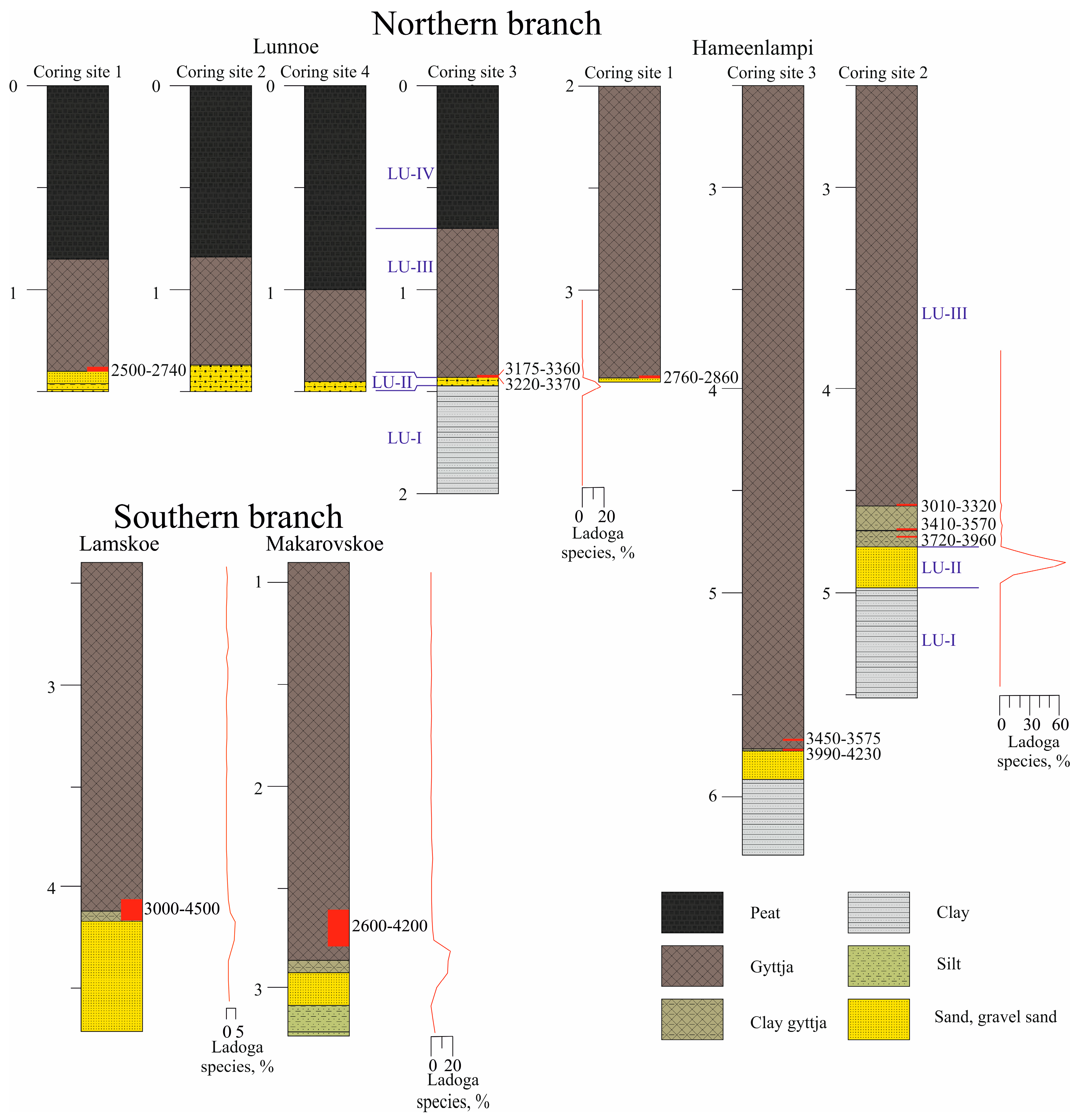
Figure 1. (A) General location and (B) a closer view of the study area: 1—Lake Saimaa; 2—the River Neva and Neva Lowland; “C” in red frame—the Heinjoki threshold area. (C) Location of the study lakes and the lakes mentioned in the text in the Heinjoki threshold area: red frames “D1” and “D2”—Lake Hameenlampi and Lake Lunnoe, respectively (this study); LM—Lake Makarovskoe; LL—Lake Lamskoe; stars—coring sites in [22,23]; LBG—Lake Bolshoe Graduevskoe; black dotted lines—present Baltic–Ladoga divide; dashed lines with arrows—present drainage directions; red dotted lines—the southern and northern branches of the Heinjoki Strait. (D1,D2)—location of the coring sites in lakes Hameenlampi and Lunnoe. (E) The Heinjoki threshold area and the hypothetical configuration of the Heinjoki Strait (blue filling) outlined on the present 20 m contour; other symbols as in (C).
Quaternary 07 00031 g001
Figure 2. The lakes Hameenlampi (A) and Lunnoe (B) at present. Large boulders rising above the lakes’ surfaces are recognizable. The terrain in the immediate vicinity of Lake Lunnoe (C), with exposed crystalline bedrock and boulders.
Quaternary 07 00031 g002aQuaternary 07 00031 g002b
Figure 3. Sediment stratigraphy (depth scale in m), lithological units (LUs) described in the text, radiocarbon dates, and proportions of the “Ladoga species” (red graphs) in the lakes belonging to the northern and southern [22,23] branches of the Heinjoki Strait (see explanations in the text).
Quaternary 07 00031 g003
Figure 4. Main lithological units and lithological contacts in Lake Hameenlampi. (A) Homogenous gyttja (LU-IIIb) immediately overlaying coarse-grained sand (LU-II) at coring site №1. (B) Indistinctly laminated clay (LU-I) in sharp contact with coarse-grained sand (LU-II). (C) Sharp contacts between LU-I, LU-II, and LU-IIIa (clayey gyttja).
Quaternary 07 00031 g004
Figure 5. Diatom diagram for Lake Hameenlampi: percentages of main diatom taxa (black dots indicate the presence re-worked marine and brackish marine diatoms in the diatom assemblages), ecological groups according to habitat preferences, diatom concentrations (g−1 dry sediment; line graph—thousands; dark gray silhouette—millions).
Quaternary 07 00031 g005
Figure 6. Diatom diagram for Lake Lunnoe: percentages of main diatom taxa (black dots indicate the re-worked marine and brackish marine diatoms presence in the diatom assemblages), ecological groups according to habitat preferences, diatom concentrations (g−1 dry sediment; line graph—thousands; dark gray silhouette—millions).
Quaternary 07 00031 g006
Table 1. Radiocarbon dates of the sediments in lakes Hameenlampi and Lunnoe.
№ IGANAMSLake,
Coring Site,
Core №
Sampling Depth (m) below the Water SurfaceSediment CompositionDated
Material
14C Date, BPCalibrated Age,
Mean ± σ
(95.4% Probability)
Data Source
8931Lunnoe, 1,11.38–1.40gyttjaTOC2540 ± 252500–2740, 2635 ± 80[42]
8932Lunnoe, 1,11.45–1.46sandPlant macrofossil245 ± 30PresentThis publication
8933Lunnoe, 3,31.46–1.47gyttjaTOC3085 ± 303220–3370, 3295 ± 40[42]
8934Lunnoe, 3,41.46–1.47sandPlant macrofossil127 ± 0.366PresentThis publication
8935Lunnoe, 3,41.42–1.43gyttjaTOC3055 ± 303175–3360, 3270 ± 50[42]
8942Hameenlampi, 1,13.42–3.43gyttjaTOC2720 ± 252760–2870, 2810 ± 30[42]
8943Hameenlampi, 2,24.705–4.715clayey
gyttja
TOC3555 ± 303720–3960, 3840 ± 60[42]
8944Hameenlampi, 2,24.67–4.68clayey
gyttja
TOC3275 ± 303410–3570, 3490 ± 40This publication
8945Hameenlampi, 2,24.55–4.56gyttjaTOC2980 ± 303010–3320, 3150 ± 60This publication
8948Hameenlampi, 3,85.75–5.76clayey
gyttja
TOC3750 ± 253990–4230, 4100 ± 60[42]
8949Hameenlampi, 3,85.70–5.71gyttjaTOC3300 ± 303450–3575, 3520 ± 40This publication
Table 2. Lithology, radiocarbon ages, and local diatom assemblage zones (LDZs) in the sediment records of lakes Hameenlampi and Lunnoe (n.a.—not analyzed).
Lake Hameenlampi, Coring Site 2
Lithological Unit (LU)Depth, mLithological Description/Contact with the Overlaying UnitLOI, % Range
(Mean)
Local Diatom Zone (LDZ)
IIIb4.6–2.5Brown homogenous gyttja23–39 (36)3 (upper 3 m n.a.)
IIIa4.81–4.6Light-brown to gray clayey gyttja/gradual, indistinct15–24 (19)3
II4.96–4.81Sand with gravel/sharp0.3–0.6 (0.4)2
I5.5–4.96Dense gray clay/sharp0.4–1.1 (0.7)1
Lake Lunnoe, coring site 3
Lithological Unit (LU)Depth, mLithological Description/Contact with the Overlaying UnitLOI, % Range
(Mean)
Local Diatom Zone (LDZ)
IV0.7–0.0Poorly decomposed peatn.a.n.a.
III1.43–0.7Brown homogenous gyttja/distinct26–64 (46)3
II1.47–1.43Sand with gravel/sharp1.0–1.3 (1.2)2
I2.0–1.47Dense gray clay/sharp0.4–3.0 (1.1)1
Table 3. A list of indicative “Ladoga species” and their presence in the diatom records of the lakes mentioned in the text.
“Ladoga Species”HameenlampiLunnoeMakarovskoeLamskoe
Achnanthes calcar Cleve++++
A. clevei Grunow++
A. joursacense Héribaud+
A. oestrupii (A.Cleve) Hustedt++++
Aulacoseira islandica (O.Müller) Simonsen++++
Cocconeis disculus (Schumann) Cleve+++
C. neodiminuta Krammer++++
Cyclotella cf. iris ++
C. schumannii (Grunow) H.Håkansson++++
Cymbella sinuata W.Gregory++
Didymosphenia geminata (Lyngbye) Mart. Schmidt++
Diploneis elliptica var. ladogensis Cleve+
Ellerbeckia arenaria (D.Moore ex Ralfs) R.M. Crawford+++
Eunotia clevei Grunow+
Gyrosigma attenuatum (Kützing) Rabenhorst
Navicula aboensis (Cleve) Hustedt++++
N. jaernefeltii Hustedt++++
N. jentzschii Grunow+++
N. scutelloides W.Smith ex W.Gregory+ +
N. tuscula Ehrenberg+
Opephora martyi Héribaud+ +
Rhoicosphenia abbreviata (C.Agardh) Lange-Bertalot+ +
Stephanodiscus cf. medius++ +
S. neoastraea Håkansson & Hickel++++
Disclaimer/Publisher’s Note: The statements, opinions and data contained in all publications are solely those of the individual author(s) and contributor(s) and not of MDPI and/or the editor(s). MDPI and/or the editor(s) disclaim responsibility for any injury to people or property resulting from any ideas, methods, instructions or products referred to in the content.

