
Riverbank Erosion and Rural Food Security in Bangladesh
by
 ,
,
Md Masum Billah
1,2,
Abahan Majumdar
2,3,4,* ,
,
Syed Mohammad Aminur Rahman
5, 
Mohammad Shah Alam
6,*,
Md Jamal Hossain
7,
Joynulalom Talukder
7,
Md Mohidul Islam
8 and
Tahmida Khanam
9 1
Ministry of Housing and Public Works, Dhaka 1000, Bangladesh
2
School of Agriculture, Policy and Development, University of Reading, Reading RG6 6EU, UK
3
Global Academy of Agriculture and Food Systems, The University of Edinburgh, Easter Bush Campus, Edinburgh EH25 9RG, UK
4
Department of Agricultural Extension, Ministry of Agriculture, Dhaka 1215, Bangladesh
5
Sustainable and Renewable Energy Development Authority, Dhaka 1000, Bangladesh
6
Department of Agricultural Extension, Mushroom Development Institute, Savar 1340, Bangladesh
7
Department of Agricultural Extension, Dhaka 1215, Bangladesh
8
Directorate of Madrasah Education, Ministry of Education, Dhaka 1000, Bangladesh
9
Department of Political Science, University of Chittagong, Chittagong 4331, Bangladesh
*
Authors to whom correspondence should be addressed.
World 2023, 4(3), 528-544; https://doi.org/10.3390/world4030033
Submission received: 21 April 2023
/
Revised: 16 August 2023
/
Accepted: 17 August 2023
/
Published: 21 August 2023
(This article belongs to the Special Issue Research on the Factors That Impact Farmer Behaviors and Decisions: From Socioeconomic Perspective)
Abstract
:The erosion of riverbanks has a negative impact on many nations across the world, costing them land, buildings, food, fish, and other living things, which forces people to relocate. Both the frequency and severity of riverbank erosion are alarming in Bangladesh. In Zajira Upazila, a baseline investigation was carried out to evaluate the effects of river erosion on the local availability of food. The results show how erosion threatens the majority of residents in the research territory. Additionally, as a consequence of the depletion of farmland brought on by the disaster and its effects, crop production is steadily dropping. Occasionally, people lose whole properties, leaving them with few employment options and little spending power. As a result, they are always in danger of experiencing a shortage of food. The suffering people use various coping strategies to deal with these challenging circumstances, such as shifting to cheaper or less appealing eating options. Despite the fact that local governing bodies have put in place various programs to help them, including food assistance and social protection programs, these are inadequate because of the government’s constrained organizational assets and competence The study’s findings will aid scientists and decision-makers in Bangladesh and abroad in better comprehending the requirements of vulnerable riverine populations and in designing programs that would increase those societies’ food safety Therefore, these results imply that developing and implementing efficient rural development strategies could increase the food security of those residing in Bangladeshi regions threatened by riverbank erosion.
1. Introduction
Bangladesh is increasingly being recognized by the world as a country prone to various natural disasters, such as riverbank erosion, floods, droughts, cyclones and storms [1,2,3,4]. These calamities pose a great challenge to the country’s sustainability in terms of food security. Approximately 40 million Bangladeshis are food-insecure and 11 million suffer from starvation [5].
The country lies on the Ganges-Brahmaputra-Meghna (GBM) river system’s alluvial floodplain along with many of its branches. The catchment area of the Ganges-Brahmaputra-Meghna (GBM) river system is approximately 1.65 million km2 [6]. The GBM river system and other waterways carry approximately 1.1 billion tons of sediments annually [6,7]. The GBM river basin has the most significant quantity of silt deposition anywhere on Earth [8,9,10]. Due to this excess silt, the river system is losing depth, resulting in frequent changes in the alignment of the channels. These natural phenomena are the main cause of fluvial floods and riverbank erosion across the river basins of Bangladesh [11]. Such natural disasters are responsible for the loss of lives and damage to land, biodiversity and infrastructure, causing a significant reduction in agricultural production and adversely affecting the country’s food security, especially that of poor people living near the banks of huge river systems [12,13]. For instance, riverbank erosion causes a yearly loss of nearly 8700 ha of homestead in Bangladesh, displacing almost 0.2 million people [14,15,16]. Due to the low-lying nature of the Bay of Bengal, during the June–September monsoon, rains prevail over Bangladesh and adjacent regions [17], which are responsible for depositing huge amounts of silt on riverbeds. This tendency in the accumulation of silt alters the structural characteristics of the rivers, which intensifies erosion in the basins of the GBM river system [7,18]. Bangladesh is home to the Padma and Jamuna rivers, which are the global rivers Ganges and Brahmaputra’s respective downstream channels [19,20]. The Padma and Jamuna combine, increasing the flow of the latter. The riverbank erosion in the Padma basin is greatly accelerated by this combined water flow [21,22]. The basins of Bangladesh’s major rivers are severely impacted by riverbank erosion in a variety of ways. The increasing influence of such natural disasters on food production has been a significant challenge for Bangladesh over the last few decades [4,23,24]. Natural disasters including cyclones, floods, droughts, and erosion are expected to have devastating effects on agricultural and food availability in the years to come in many regions of the world, especially in emerging nations like Bangladesh [13,16,25].
Since rice is the primary food in Bangladesh, the achievement or failure of agricultural products and shortages of water in any given year are all considered with the utmost concern. In Bangladesh’s total economic development, its agricultural industry is crucial. One of the most defining characteristics of monsoon regions around the world is the periodical variance in rainfall. In Bangladesh, the rainy season lasts for a period of four months, from June to September, with significant regional and seasonal differences [26]. During the non-monsoon season, a countrywide shortage of water is caused by such an elevated level of rainfall. A regular monsoon with equal amounts of rainfall is a blessing, but an excessive occurrence that causes widespread flooding or drought in the entire country or a specific region is an environmental risk. Thus, ensuring the accessibility of sufficient water for watering under altered climatic conditions is crucial for Bangladesh, where cultivation has an important effect on its financial situation and way of life. A reliable supply of water is the primary factor that controls the output of agriculture.
In a nation where there is a shortage of agricultural land, riverbank erosion lowers the overall area of cultivated land each year. For example, Bangladesh has 0.05 hectares of cultivated land per inhabitant. This results in a decrease in aggregate food production and, as a result, has a negative influence on the food and livelihood insecurity of the vulnerable riverine population. The country’s internal migration and relocation are frequently caused by erosion. Specifically for those focused on decreasing poverty and hunger, the danger of riverbank erosion is seen as one of the primary barriers preventing Bangladesh from accomplishing its MDGs [27]. SDG 2.1 revealed that by 2030, we must end hunger and ensure access for all people, in particular, the poor and people in vulnerable situations, including infants, to safe, nutritious, and sufficient food all year round (https://www.un.org/sustainabledevelopment/hunger/, accessed on 1 January 2020). Besides, For sustainable development, it is vital to consider the land-river interface (LRI). The natural resources and ecosystem services that are directly connected to numerous Sustainable Development Goals (SDGs) are supported by the environmental processes that determine the LRI [28]. Every year, riverbank erosion affects millions of people by causing damage to and loss of crops, cattle, housing structures, and farmland. It also deteriorates public infrastructure and communication networks. The Padma River’s bank lines are very unstable. Recently, the right bank of the Padma has been threatened by severe erosion, particularly in Zajira Upazila of the Shariatpur district.
In Bangladesh, food security has been a major concern since the country’s independence because it is closely related to poverty reduction programs and the prosperity of the citizens. The nation recently achieved food sufficiency, having reduced its poverty rate from 62% in 1988 to 23.2% in 2016. In Addition, a third of households have experienced homestead loss more than three times in the past ten years, and 57% have experienced at least one loss [29]. A clean rice growth rate of 0.34 million tons (MT) per year has been achieved in Bangladesh because of the combined efforts of rice scientists, extension workers, and farmers. By 2050, Bangladesh will have a population of 215.4 million, at which time 44.6 MT of clean rice would be needed [30]. Thus, the multidimensional impacts of riverbed erosion should be explored to ensure the country’s food security situation, and effective steps must be taken to improve the socioeconomic condition of the affected rural people [1,4]. Besides, women have great difficulty finding new homes immediately after losing practically everything to the river, in addition to additional work demands, family conflicts, health issues, social neglect, and feelings of insecurity [31]. In this study, the aim was to investigate the impacts of riverbank erosion on the food security of rural households near the Padma River basin and their coping strategies.
Most of Bangladesh’s rural people rely on agriculture, which is particularly vulnerable to climate change. Therefore, issues related to global warming in general and the persistent threat of riverbank erosion specifically have an effect on the rural riverine societies in Bangladesh. Global warming impacts are expected to alter the occurrence of overflowing [32,33], raising the erosion danger along rivers [34,35]. Initial and second-order disaster consequences, as well as both direct and indirect risk effects, are often used terms [36]. Riverbank erosion contributes to the annual loss of riverine households’ land, homesteads, ponds, crops, trees, and other resources (Figure 1). Their income and work prospects have been reduced as a result of the loss of land and resources. Besides, being homeless, the mental health of riverbank societies is degrading day by day [37] and homeless/displaced persons typically seek shelter in open spaces, embankments, and high land, as seen in Figure 1. Due to these circumstances, the livelihoods of riverine households are in danger. In addition, they will probably see an increase in mean annual temperature brought on by changes in the climate, in addition to unpredictability in rainfall, a possible decline in cereal crop yield, and a rise in the impacts of disease, insects, and weeds on both crops and animals [38,39]. Moreover, poor socioeconomic conditions, sickness, medical costs, and loss of property are just a few of the horrible effects of riverbank erosion [40]. Due to erosion and the presence of rivers nearby, their surroundings are extremely volatile, making them susceptible to flooding. Decreased food allowances for households, especially for small farmers and landless people, are a result of lower food production, poorer employment prospects, and volatile food prices. As a consequence, food scarcity will have the greatest initial impact in a community where a great many households depend on farming, as in our study. To deal with the risks at this time, riverine communities employ a number of adaptation and mitigation strategies (Figure 1).
These techniques for adaptation may be put into practice on individual farms or in a planned fashion (by means of government policy). The fact that not all families are equally impacted by the impacts of climate change and its threats should be emphasized. As a result, how each household responds will depend on its economic condition and the social and political relationships that exist in that community [12,41]. As a result, it is important to include a variety of livelihood possibilities as well as assets for adaptation when evaluating the dependence on agriculture of riverine households and their level of food availability. However, there were several limitations to this study, such as fewer reports from women, environmental difficulties like cyclones, heavy rain, and so on.
This study uses data from cross-sectional surveys to look at how remote riverine families react to such risks alongside additional warming-related problems in order to lessen severe livelihood and food scarcity situations that frequently result in migration and inter-country movement. Policymakers might concentrate on community adaptation attempts, which are considered essential to lowering food insecurity and improving the livelihoods of poor farmers, by recognizing the fragility of households and tactics for responding [42,43]. Therefore, to improve mental and physiological health and socioeconomic conditions, it is vital to minimize riverbank erosion in Bangladesh. This study will contribute to understanding Bangladesh’s riverbank erosion’s causes and likely government- and non-government-sponsored solutions.
2. Materials and Methods
2.1. Brief Description of the Study Site
The study was conducted in the Zajira sub-district of Shariatpur district, which is 100 km to the southeast of Bangladesh’s capital, Dhaka. Zajira is situated to the south of the Padma (Figure 2). The total land area of this sub-district is 246.21 km2, and its total population is 194,019 (https://en.wikipedia.org/wiki/Zajira_Upazila, accessed on 11 July 2014). The frequency of riverbank erosion is rather high in this region. Most of the people here are involved in agriculture.
Zajira belongs to the Lower Ganges River Floodplain Agro-Ecological Zone. The organic matter content in the soil here is low, which is mainly responsible for its low fertility status [44]. The main agricultural crops in Zajira are rice, oil seed, spices and pulses [35]. Figure 3 shows some images of the lifestyle and eroding riverbanks along the Padma (Zajira) river.
2.2. Primary Data Collection
In the study under discussion, multistage sampling was done to collect both qualitative and quantitative data. We collected primary data for quantitative analysis by number, for example, married or unmarried, family size, and occupation as well. Also, we measured qualitative data through respondents’ opinions or assumptions, which include experience, household food, security status, housing condition, education facilities, and so on, regarding riverbank erosion. A personal interview and a questionnaire survey were conducted among the inhabitants of the Padma riverbank and local public representatives in the affected area. Researchers obtained ethical clearance (APD Ethical Clearance Application Number: 1088C) from the University of Reading before starting the field survey. Participants from two unions were interviewed, and a 5% random sampling design was used from 1000 people. The cross-sectional sampling method was applied [1]. A total of 60 villagers and 20 local public representatives were selected for the study on a random basis. Computer-generated numbers were allocated for the questionnaires to ensure a random sampling of the interviewed household heads or members (in the absence of household heads). The enumerators moved to another participant when a respondent was non-responsive, and thus they continued interviewing till the required number of respondents was reached.
The questionnaire used to conduct the survey was semi-structured and contained a mix of open-ended and closed questions. First, a draft questionnaire was developed based on previous research findings and suggestions of the research supervisor. Before starting the final survey, arrangements were made for pre-testing the draft questionnaire to eliminate any ambiguity in the questions and ensure the collection of accurate and sufficient data. While the questionnaire for the local government representatives had only one section, the questionnaire for the riverbank-erosion-affected people had three sections: Section A covered demographic data, Section B was used to collect information on socioeconomic aspects, and Section C contained questions on riverbank erosion, its impact on the local people and their coping strategies. The enumerators are government servants working at the union level under the supervision of the Upazila (sub-district level) and the Department of Agricultural Extension (DAE) of the government of Bangladesh. The survey and interview of the participants were conducted in August 2019.
2.3. Data Validation
Some techniques were followed to ensure the validity and reliability of the survey, such as developing and finalizing the questionnaires’ incomprehensible language. Researchers ensured that all participants understood the questions before starting the interview through Skype, and the research supervisor also briefed them about the questionnaire. Under the research supervisor’s guidance, the questionnaires were finalized. All the interviews were audio-recorded with the respondents’ consent to ensure the credibility of the interview process. Further, the data provided by the study participants were compared with different reports of relevant research organizations to ensure the validity and reliability of the results.
2.4. Secondary-Data Collection
Secondary data were collected to support the primary data collected from the respondents. The sources for these data were published reports and the websites of different organizations under the Bangladesh government.
2.5. Data Analysis
The data were analyzed using PRIMER v7.0.21 [45] and SPSS v22 software. Using an appropriate scoring technique, the qualitative data were converted into quantitative data wherever necessary. To describe different variables, statistical measures, such as means and number and percentage distributions, were used.
3. Results
3.1. Demographic Details of Respondents
According to demographic features, most of the study respondents were male (90%), and the remaining 10% were female. Moreover, it was found that many of them were middle-aged; those belonging to the age groups of 31–45 years and 46–59 years constituted 31.7% and 33.3% of the participants, respectively. Regarding marital status, it was observed that 95% of them were married, and only the remaining 5% were unmarried. Further, the majority of the respondents (70.0%) had a large family, whereas very few (1.7%) had a small family (Figure 4). These results suggested that the respondents were mature enough and were vulnerable to riverbank erosions.
3.2. Agriculture Is the Main Source of Living
The researchers found that the maximum number of participants (71.7%) practiced agriculture as their main occupation, whereas a negligible percentage (1.7%) earned primarily through livestock farming. Regarding land ownership, the majority of the participants (63.3%) reported having land of their own, while 36.7% did not own land. Further, most of the respondents (91.7%) stated that their own products did not fulfill the annual food demands of their families. While 60% of them mentioned they purchased food to satisfy their family’s requirements, 35% stated that they received food aid and also purchased food to fulfill their household demands (Figure 5). These results showed that, despite the fact that agriculture is their primary source of income, they still had to buy food to meet their needs, which might be the result of a decrease in fertile land caused by riverbank erosion.
3.3. People Affected Severely by Erosion and Lost Agricultural Products
The first question posed to the local people during their interview was, ‘Do you live in the Padma river basin?’ All the participants answered in the affirmative. Then, they were questioned about the existence of riverbank erosion in their area. Again, all respondents stated that they observed riverbank erosion in their locality. Approximately 97% of them (Table 1) said that they were affected by riverbank erosion. Despite the fact that riverbank erosion proceeds slowly and progressively year after year, it has long-term and irreversible consequences.
The interviewees also provided information about the different types of land eroded. They had lost their cropland. They had also lost ponds, vegetable and fruit gardens and, homesteads, commercial and other lands due to riverbank erosion. The participants’ responses are presented in Figure 6. Riverbank spills and erosion are common during the monsoon season in Bangladesh. Riverbank erosion in Bangladesh is mostly caused by the braided character of the rivers, which is exacerbated by excessive rainfall, particularly upstream, and increased water flow. The pace of riverbank erosion has recently accelerated dramatically as a result of climate change, culminating in the unexpected collapse of riverbanks and the devastation of entire Unions and Upazilas.
3.4. Declined Household Food Security and Livelihood
Regarding household food security, some parameters were used to evaluate the effects of riverbank erosion on the people’s lives and livelihoods, such as food shortage, a decline in income sources, disruption in communication, destruction of the homestead, trouble in availing public services and disruption in transportation (Figure 7).
The majority of the respondents (88.3%) stated that riverbank erosion had caused food shortages in their households, and 73.3% of them mentioned that their income sources had declined due to the disaster (Figure 7). A recently published study found that the loss of agricultural land leads to a decline in total crop yield. However, their research was conducted in Harirampur, Manikgonj district, on the Padma River. Our results were nearly identical to theirs, although the location was different. Their responses to the interview question ‘What is your household food security situation throughout the year?’ are presented in Table 2. Between January and June, food was secured by around 53% of the respondents, whereas the others mentioned that their household food security was inadequate during that period. In contrast, only 15% of them reported securing food for their households during July–December, while the majority (61.7%) revealed food scarcity.
With respect to household food security, the first question posed was, ‘Were members of your household anxious about the lack of sufficient food during the last three months?’ Almost 98% of the respondents stated that they were sometimes anxious over the lack of sufficient food during the previous 3 months (Table 3).
The next questions were, ‘Were any members of your household—including yourself—forced to go without meals one or more days over the past three months because there wasn’t enough food? and “Have you or anyone else in the family gone to bed starving because there wasn’t enough food to go around in the past three months?” In both cases, all respondents answered ‘No’ (Table 3).
With regard to the availability of different kinds of food from their own produce, the interviewees mentioned that rice covered the highest period of 2.55 months, followed by milk (1.9 months), whereas meat sustained them for only 0.32 months (Table 4).
3.5. Riverbank Erosion Damaged Social Life
The impacts of riverbank erosion on social life including housing, health facilities, education, communication and many other parameters were measured through 17 questions (Table 5). The answer options were ‘No change’ (0), ‘Deteriorated’ (1) and ‘Improved’ (2). Most (91.7%) of the respondents stated that their housing conditions had deteriorated due to the disaster. Further, 88.3% of them reported that occupation opportunities for their household members had declined. However, some also mentioned that electricity and health, transport, education and marketing facilities in their area had improved (Table 5).
3.6. The Riverbank-Erosion-Affected People Migrated Helplessly Leaving Properties
The research respondents were asked fifteen questions about their coping mechanisms for securing food, with the response possibilities being “regularly” (3), “occasionally” (2), “rarely” (1), and “not at all” (0). Their responses are presented in Table 6. The majority of them (61.7%) mentioned that they migrated to the city when their food security came under threat due to riverbank erosion. The respondents’ views on the existence of government and non-government food programs for them are illustrated in Table 5. Among them, 78.3% confirmed that there was no food aid program for those who lost land to erosion in their area. However, 68.3% mentioned that their family members were under government safety net programs. Nevertheless, 93.3% of the participants reported that these programs were inadequate. Furthermore, none of them were under any NGO food program.
3.7. Local-Government Representative’s Initiatives Are Limited
Of the interviewed local government representatives, 85% revealed severe riverbank erosion in their area. The respondents had been representatives for 9.55 years on average. Almost all of them reported that there were food aid programs to ensure food security for the local people, and according to them, on average, 281.80 people were beneficiaries of such programs in their respective areas. When the local government representatives were asked if they had seen any migration tendencies among the affected people in their jurisdiction, almost all of them answered in the affirmative. In addition, they mentioned that, on average, 414.75 affected people had migrated to cities or other places over the previous 5 years commencing in 2015. Regarding strategies to mitigate riverbank erosion in their area, about 65% of the respondents stated that they had action plans, whereas the rest had none (Table 7).
3.8. Inefficient Action Plans for Erosion Control in the Study Area
The study participants mentioned some action plans, which are summarized in Table 8. The local-government representatives were involved in implementing some measures to control riverbank erosion, such as throwing geotextile bags, setting cement concrete blocks and dredging the riverbeds taken by other government agencies. They supported the agencies and motivated local people to participate in the implementation processes. The respondents also mentioned that mitigation plans against riverbank erosion were hindered by a lack of institutional capacity, resource constraints and gaps in coordination among the relevant organizations.
4. Discussion
In most areas of Bangladesh, riverbank erosion is a common occurrence that impacts about one million people annually [12,39,41]. Besides, riverbank erosion is a serious issue in Bangladesh that annually causes the displacement of millions of people and negatively impacts their psychological well-being [37,46]. The social, physical, and financial conditions in a given area are significantly impacted by riverbank erosion [33]. Additionally, it increases the vulnerability of marginalized and poor people because of their reduced ability to deal with disasters.
The previous study of river erosion revealed higher male participation (male and female respondents are 23.96% and 9.91%, respectively) in the Koyra upazila in Bangladesh [47]. Our research also showed a similar trend that might be due to religious constraints or that females are not as interested in talking to the interviewer as males are assumed to be the heads of almost all families. Generally, agriculture is the main source of income for Bangladeshi people [48]. In some places, almost half of the household heads engage in fishing as their primary or secondary occupation, specifically in the coastal area [49]. In our study, agricultural crops were the main source of their daily income; maybe they have less opportunity to catch fish or pursue other occupations. Because they lost their land through riverbank erosion, people are now economically very weak, which results in a vulnerable socioeconomic condition.
In the study area, riverbank-erosion-affected people were involved in various occupations, among which agriculture was the main income source for most of them. On the other hand, livestock farming, aquaculture and fishing were insignificant sources of income for them. Furthermore, the income source of many affected people was not specific. The study participants mentioned using a significant portion of their income to purchase food since the majority of them could not produce sufficient food of their own [13,44]. However, many of them were brought under government safety net programs such as Vulnerable Group Feeding, programs to cope with natural disasters and other shocks, and employment generation programs. Bangladesh’s status with regard to food availability is seriously threatened by riverbank erosion. Coping is usually a crucial alternative for overcoming this long-term devastation [20]. All of those who responded to the poll, who all resided close to the Padma River, said that riverbank erosion had upset them over the past ten years virtually universally, based on the questionnaire’s data. They mentioned that in the affected area, cropland suffered the highest erosion among the different classes of land.
The lives and livelihoods of the people were upset because of the food shortage, destruction of the homestead, decline in income sources, trouble in availing public services and disruption in communication and transportation caused by riverbank erosion. The situation regarding food security varied from month to month. The participants indicated that from January to June, they could secure food, but from July–December, their situation deteriorated [50]. The probable reason behind this is that July–September is the most vulnerable time for crop production, whereas January–March is the safest period for this activity (http://oldweb.lged.gov.bd/ViewMap.aspx, accessed on 1 July 2022).
In terms of household indicators, the majority of the respondents mentioned that their housing condition had deteriorated due to damage to their houses caused by riverbank erosion (http://oldweb.lged.gov.bd/ViewMap.aspx, accessed on 1 July 2022). Regarding their coping strategies for food security, they revealed that when stressed, they migrated to urban areas to earn some extra money. Moreover, some people coped with food scarcity by relying on less expensive or less preferred food items and spending money from their savings [12]. The survey results confirm that in the study area, food aid programs are limited. However, most erosion-affected individuals are covered by government security net initiatives, such as meal-for-work and profit-for-work programs. Such initiatives are implemented by different government organizations. Riverbank erosion has many negative impacts on riverine villagers [16]. However, the respondents in the present study were found to follow some coping mechanisms. In previous studies, researchers have found riverbank erosion-affected people to follow several coping strategies. The important coping strategies they have identified are finding part-time work, treating diseases, undertaking emergency house refurbishment, living on embankments or highlands temporarily and changing occupations [1,3].
The government and non-government institutional setting is very important in the selection of coping options for riverbank-erosion-affected people [45]. The study shows that local government representatives of the study area have provided some help to the affected people by implementing food aid and safety net programs. However, the number of beneficiaries under such programs is not significant. The representatives indicated in the study that a considerable number of affected people migrated to cities and other places. Further, they mentioned that they had implemented some action plans for protecting people from riverbank erosion. While these schemes were mainly implemented by some other government agencies, they played their role by supporting these initiatives and motivating the local people to help them. However, they also mentioned that they had little capacity to take mitigation steps against riverbank erosion due to resource constraints and a lack of coordination among the relevant organizations.
Lastly, besides outside support, the traditional knowledge and skills of the locals are important factors that may significantly help them overcome the challenges posed by natural disasters. This argument is supported by Islam et al., who stated that an appropriate system for forecasting the water flow of rivers and floods and the integration of local techniques and modern technologies can help reduce the impacts of riverbank erosion [23].
5. Conclusions
Riverbank erosion is the most common natural disaster in riverine Bangladesh. According to the present research, in the Zanjira sub-district of Shariatpur district, a densely populated area, most of the people, who are also poor and marginalized, are affected by this natural disaster. Many even lose their entire homestead. Therefore, in many cases, people migrate to urban areas. Due to the loss of their farmlands, their agricultural production is decreasing day by day. Moreover, their purchasing capacity is quite low because of the lack of other income sources. Thus, they are regularly affected by food scarcity, especially during July–December. Consequently, almost all people are anxious about a shortage of food, though the number of hungry locals is quite small in the study area. While many residents have been brought under the social safety net and food aid programs of the government, these are not sufficient to help all the affected people.
Besides the government’s initiatives, the distressed locals follow some coping mechanisms during stressful situations. Others cope with food scarcity by relying on less expensive or less preferred food items and spending money from their savings. The local government representatives also play their part in assisting the riverbank-erosion-affected people through government schemes. Overall, in order to protect local people’s lives, the river, and Bangladesh’s natural environment, it is urgent to reduce riverbank erosion with the cooperation of the government and non-government organizations. To ensure people’s socioeconomic standing, it is necessary to promote current technology and create new strategies for minimizing riverbank erosion.
Author Contributions
Conceptualization, M.M.B. and A.M.; methodology, M.M.B. and T.K.; software, M.S.A., J.T. and M.M.I.; validation, M.J.H. and M.M.B.; formal analysis, A.M.; investigation, M.M.B. and A.M.; resources, A.M. and J.T.; data curation, M.J.H. and T.K.; writing—original draft preparation, A.M.; writing—review and editing, M.S.A. and S.M.A.R.; visualization, A.M. and M.M.I.; supervision, S.M.A.R.; project administration, M.M.B.; funding acquisition, M.M.B. All authors have read and agreed to the published version of the manuscript.
Funding
This research received no external funding.
Institutional Review Board Statement
The researchers had taken the ethical clearance before starting field survey. The ethical clearance number: APD 1088C, date of approval: 29 July 2019, School of Agriculture Policy and Development, University of Reading, Post Code: RG6 6AH, UK.
Informed Consent Statement
Informed consent was obtained from all subjects involved in the study.
Data Availability Statement
The data presented in this study are available within the article.
Acknowledgments
This research was a part of MSc in Applied International Development at the School of Agriculture, Policy and Development, University of Reading, United Kingdom. The MSc study program was funded by the “Strengthening Government through Capacity Development of the Bangladesh Civil Service Cadre Officials Project, Phase II”, administered by the Ministry of Public Administration, Government of the People’s Republic of Bangladesh, Dhaka 1000.
Conflicts of Interest
The authors declare no conflict of interest.
References
- Alam, G. An Assessment of the Livelihood Vulnerability of the Riverbank Erosion Hazard and Its Impact on Food Security for Rural Households in Bangladesh. Ph.D. Thesis, University of Southern Queensland, Toowoomba, Australia, 2016. [Google Scholar]
- Hossain, M.; Ferdousi, S. Assessment for role of GIS Based Natural Disaster Database in Environmental Management and Planning Activity in Bangladesh. Environ. Inform. Arch. 2004, 2, 119–125. [Google Scholar]
- Rahman, M.; Islam, M. Bank erosion pattern analysis by delineation of course migration of the padma river at harirampur upazila using satellite images and GIS part II. J. Geol. Amp. Geophys. 2017, 6. Available online: https://www.longdom.org/open-access/bank-erosion-pattern-analysis-by-delineation-of-course-migration-of-the-padma-river-at-harirampur-upazila-using-satellit-41121.html (accessed on 1 July 2022).
- Monirul Alam, G.; Alam, K.; Mushtaq, S. Drivers of food security of vulnerable rural households in Bangladesh: Implications for policy and development. South Asia Econ. J. 2018, 19, 43–63. [Google Scholar] [CrossRef]
- Alam, M.R.; Hossain, M.; Shahadat, C.; Pinaki, S.A.H.; Alam, M.; Bashir, U. Assessment of Food Security Status and the determinants of food security in selected households from coastal area of Noakhali, Bangladesh. Indian J. Public Health Res. Dev. 2020, 11, 210–217. [Google Scholar]
- Sarker, M.H.; Huque, I.; Alam, M.; Koudstaal, R. Rivers, chars and char dwellers of Bangladesh. Int. J. River Basin Manag. 2003, 1, 61–80. [Google Scholar] [CrossRef]
- Aktar, N. Prediction of River Bank Erosion Along the Jamuna, the Ganges the Padma and the Lower Meghna Rivers in 2012; Center for Environmental and Geographic Information Services: Dhaka, Bangladesh, 2012. [Google Scholar]
- Chowdhury, M. The 1987 flood in Bangladesh: An estimate of damage in twelve villages. Disasters 1988, 12, 294–300. [Google Scholar] [CrossRef]
- Kuehl, S.A.; Hariu, T.M.; Moore, W.S. Shelf sedimentation off the Ganges-Brahmaputra river system: Evidence for sediment bypassing to the Bengal fan. Geology 1989, 17, 1132–1135. [Google Scholar] [CrossRef]
- Hasan, M.; Quamruzzaman, C.; Rahim, A.; Hasan, I.; Methela, N.; Imran, S. Determination of river bank erosion probability: Vulnerability and risk in southern shoreline of Bangladesh. Int. J. Energy Sustain. Dev. 2018, 3, 44–51. [Google Scholar]
- Elahi, K.M.; Rogge, J. Riverbank Erosion, Flood, and Population Displacement in Bangladesh; IDRC-CRDI: Ottawa, ON, Canada, 1990. [Google Scholar]
- The Intergovernmental Panel on Climate Change. Impacts, Adaptation and Vulnerability. Part A: Global and Sectoral Aspects. Contribution of Working Group II to the Fifth Assessment Report of the Intergovernmental Panel on Climate Change; IPCC: Geneva, Switzerland, 2014; p. 1132. [Google Scholar]
- Das, T.K.; Haldar, S.K.; Gupta, I.D.; Sen, S. River bank erosion induced human displacement and its consequences. Living Rev. Landsc. Res. 2014, 8, 3. [Google Scholar] [CrossRef]
- GoB. Comprehensive Disaster Management Programme, Phase II (2010–14); Ministry of Disaster Management and Relief: Dhaka, Bangladesh, 2010. [Google Scholar]
- Islam, M.F.; Rashid, A.B. Riverbank erosion displacees in Bangladesh: Need for institutional response and policy intervention. Bangladesh J. Bioeth. 2011, 2, 4–19. [Google Scholar] [CrossRef]
- Rahman, M.A.; Rahman, S. Natural and traditional defense mechanisms to reduce climate risks in coastal zones of Bangladesh. Weather Clim. Extrem. 2015, 7, 84–95. [Google Scholar] [CrossRef]
- Gain, A.K.; Giupponi, C.; Renaud, F.G. Climate change adaptation and vulnerability assessment of water resources systems in developing countries: A generalized framework and a feasibility study in Bangladesh. Water 2012, 4, 345–366. [Google Scholar] [CrossRef]
- Hossain, M. Economic effects of riverbank erosion: Some evidence from Bangladesh. Disasters 1993, 17, 25–32. [Google Scholar] [CrossRef] [PubMed]
- Hutton, D.; Haque, C.E. Patterns of coping and adaptation among erosion-induced displacees in Bangladesh: Implications for hazard analysis and mitigation. Nat. Hazards 2003, 29, 405–421. [Google Scholar] [CrossRef]
- Iqbal, S. Flood and erosion induced population displacements: A socio-economic case study in the Gangetic riverine tract at Malda district, West Bengal, India. J. Hum. Ecol. 2010, 30, 201–211. [Google Scholar] [CrossRef]
- Islam, S.N.; Singh, S.; Shaheed, H.; Wei, S. Settlement relocations in the char-lands of Padma River basin in Ganges delta, Bangladesh. Front. Earth Sci. 2010, 4, 393. [Google Scholar] [CrossRef]
- Islam, M.; Hasan, T.; Chowdhury, M.; Rahaman, M.; Tusher, T. Coping techniques of local people to flood and river erosion in char areas of Bangladesh. J. Environ. Sci. Nat. Resour. 2012, 5, 251–261. [Google Scholar] [CrossRef]
- Islam, M.R. Climate change, natural disasters and socioeconomic livelihood vulnerabilities: Migration decision among the char land people in Bangladesh. Soc. Indic. Res. 2018, 136, 575–593. [Google Scholar] [CrossRef]
- Keya, M.; Harun, S. Riverbank erosion induced stress and coping of displaced women in Bangladesh. Empowerment 2007, 14, 17–30. [Google Scholar]
- Analytics, C. Turn Down the Heat: Climate Extremes, Regional Impacts, and the Case for Resilience; The World Bank: Washington, DC, USA, 2013. [Google Scholar]
- Kripalani, R.; Inamdar, S.; Sontakke, N. Rainfall variability over Bangladesh and Nepal: Comparison and connections with features over India. Int. J. Climatol. J. R. Meteorol. Soc. 1996, 16, 689–703. [Google Scholar] [CrossRef]
- Rahman, M.M. Capacities and Responses to Disaster Governance in Bangladesh: A Reflection from the SDGs. Civ. Environ. Res. 2018, 10, 45–58. [Google Scholar]
- Durán-Sandoval, D.; Durán-Romero, G.; Uleri, F. How Much Food Loss and Waste Do Countries with Problems with Food Security Generate? Agriculture 2023, 13, 966. [Google Scholar] [CrossRef]
- Alam, G.M.; Alam, K.; Mushtaq, S.; Sarker, M.N.I.; Hossain, M. Hazards, food insecurity and human displacement in rural riverine Bangladesh: Implications for policy. Int. J. Disaster Risk Reduct. 2020, 43, 101364. [Google Scholar] [CrossRef]
- Kabir, M.; Salam, M.; Chowdhury, A.; Rahman, N.; Iftekharuddaula, K.; Rahman, M.; Rashid, M.; Dipti, S.; Islam, A.; Latif, M. Rice vision for Bangladesh: 2050 and beyond. Bangladesh Rice J. 2015, 19, 1–18. [Google Scholar] [CrossRef]
- Akter, K.; Dey, S.; Hasan, S. Riverbank erosion and its impact on rural women: Case study of Ulania village in Bangladesh. Asian J. Women’s Stud. 2019, 25, 76–95. [Google Scholar] [CrossRef]
- Revi, A. Climate change risk: An adaptation and mitigation agenda for Indian cities. Environ. Urban. 2008, 20, 207–229. [Google Scholar] [CrossRef]
- Ahmed, A.U. Bangladesh Climate Change Impacts and Vulnerability: A Synthesis; Climate Change Cell, Department of Environment: Chennai, India, 2006. [Google Scholar]
- Ericksen, N.; Ahmad, Q.; Chowdhury, A. Socio-economic implications of climate change for Bangladesh. In The Implications of Climate and Sea–Level Change for Bangladesh; Springer: Berlin/Heidelberg, Germany, 1996; pp. 205–287. [Google Scholar]
- Kates, R.W.; Hare, F.K.; Riebsame, W.E.; Maunder, W.; Ausubel, J.; Nix, H.A.; Kawasaki, T. SCOPE 27 Climate Impact Assessment-Studies of the Interaction of Climate and Society; John Wiley: Hoboken, NJ, USA, 1985. [Google Scholar]
- Field, C.B.; Barros, V.R. Climate Change 2014–Impacts, Adaptation and Vulnerability: Regional Aspects; Cambridge University Press: Cambridge, UK, 2014. [Google Scholar]
- Naher, J.; Soron, T.R. Impact of river bank erosion on mental health and coping capacity in Bangladesh. Glob. Psychiatry 2019, 2, 195–200. [Google Scholar]
- Molua, E.L. An empirical assessment of the impact of climate change on smallholder agriculture in Cameroon. Glob. Planet. Chang. 2009, 67, 205–208. [Google Scholar] [CrossRef]
- Paul, B.K. Coping mechanisms practised by drought victims (1994/5) in North Bengal, Bangladesh. Appl. Geogr. 1998, 18, 355–373. [Google Scholar] [CrossRef]
- Kaiser, Z.A. Analysis of the livelihood and health of internally displaced persons due to riverbank erosion in Bangladesh. J. Migr. Health 2023, 7, 100157. [Google Scholar] [CrossRef]
- Emel, J.; Peet, R. Resource management and natural hazards. In New Models in Geography-Vol 1; Routledge: Abingdon, UK, 2002; pp. 69–99. [Google Scholar]
- Lobell, D.B.; Burke, M.B.; Tebaldi, C.; Mastrandrea, M.D.; Falcon, W.P.; Naylor, R.L. Prioritizing climate change adaptation needs for food security in 2030. Science 2008, 319, 607–610. [Google Scholar] [CrossRef] [PubMed]
- Adger, W.N.; Arnell, N.W.; Tompkins, E.L. Successful adaptation to climate change across scales. Glob. Environ. Chang. 2005, 15, 77–86. [Google Scholar] [CrossRef]
- Statistics, B. District Statistics 2011; Ministry of Planning, Government of The People’s Republic of Bangladesh: Dhaka, Bangladesh, 2013. [Google Scholar]
- Rahman, M. Validation of Regional Climate Model Simulation with Observational Data over Bangladesh. Ph.D. Thesis, Bangladesh University of Engineering and Technology, Dhaka, Bangladesh, 2006. [Google Scholar]
- Hossain, A.; Alam, M.J.; Haque, M.R. Effects of riverbank erosion on mental health of the affected people in Bangladesh. PLoS ONE 2021, 16, e0254782. [Google Scholar] [CrossRef] [PubMed]
- Rahman, M.S.; Gain, A. Adaptation to river bank erosion induced displacement in Koyra Upazila of Bangladesh. Prog. Disaster Sci. 2020, 5, 100055. [Google Scholar] [CrossRef]
- Roy, D.; Goswami, S.; Ahmed, T.; Saha, M.K.; Emon, M.H.; Rahim, M.A. Socio-economic impacts of river bank erosion on Durgapasha Union in Bakerganj Upazila, Bangladesh. Barisal Univ. J. Part 2017, 1, 1. [Google Scholar]
- Mallick, A.; Mallick, B. Staying despite riverbank erosion: Evidence of coastal Bangladesh. SN Soc. Sci. 2021, 1, 155. [Google Scholar] [CrossRef]
- Bhuiyan, M.A.H.; Islam, S.D.-U.; Azam, G. Exploring impacts and livelihood vulnerability of riverbank erosion hazard among rural household along the river Padma of Bangladesh. Environ. Syst. Res. 2017, 6, 25. [Google Scholar] [CrossRef]
Figure 1.
Conceptual framework of the study.
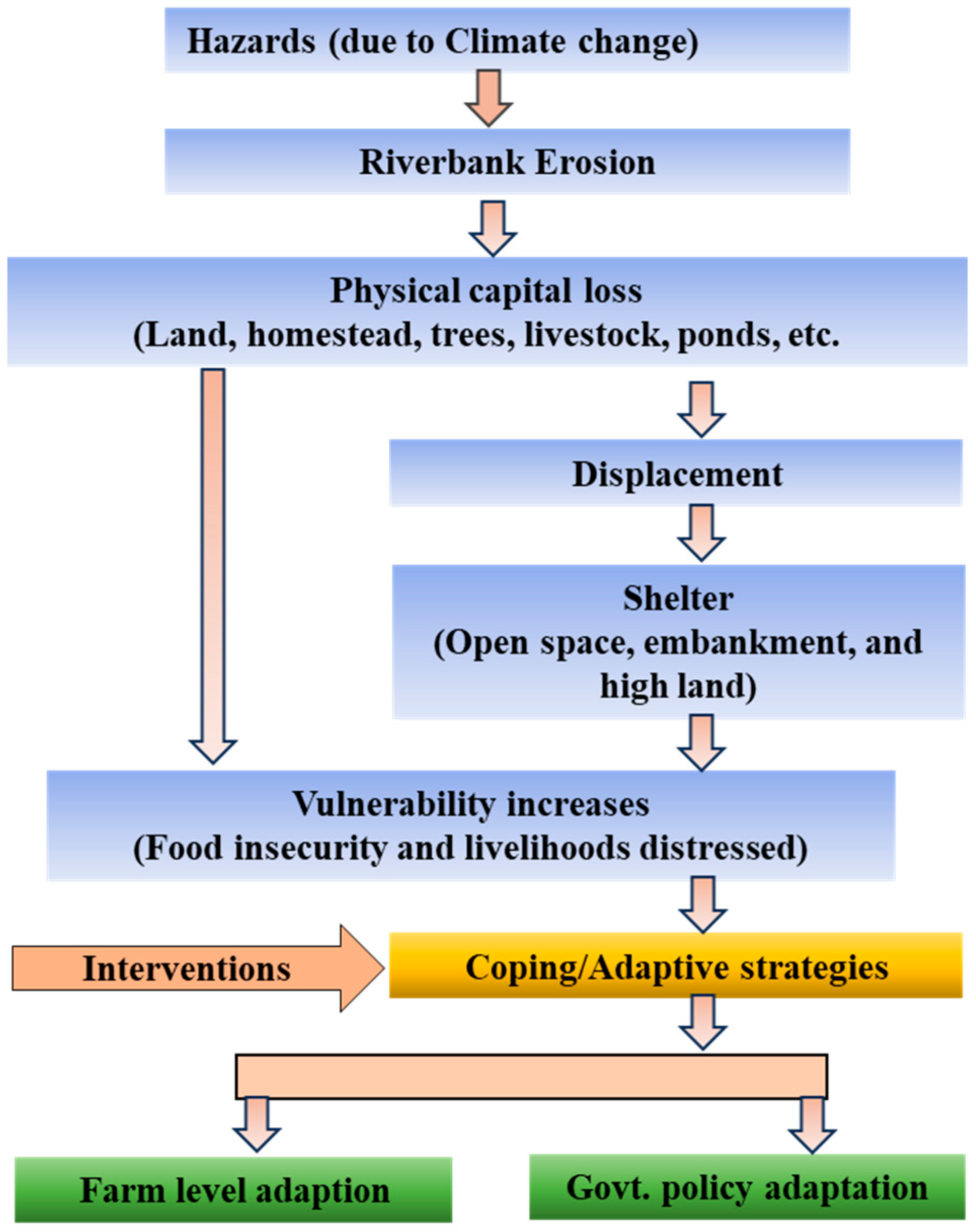
Figure 2.
The study area shown in the map of Bangladesh (Source: BBS, 2019).

Figure 3.
Riverbank erosion and livelihood in the study areas in Zajira, Sariatpur.
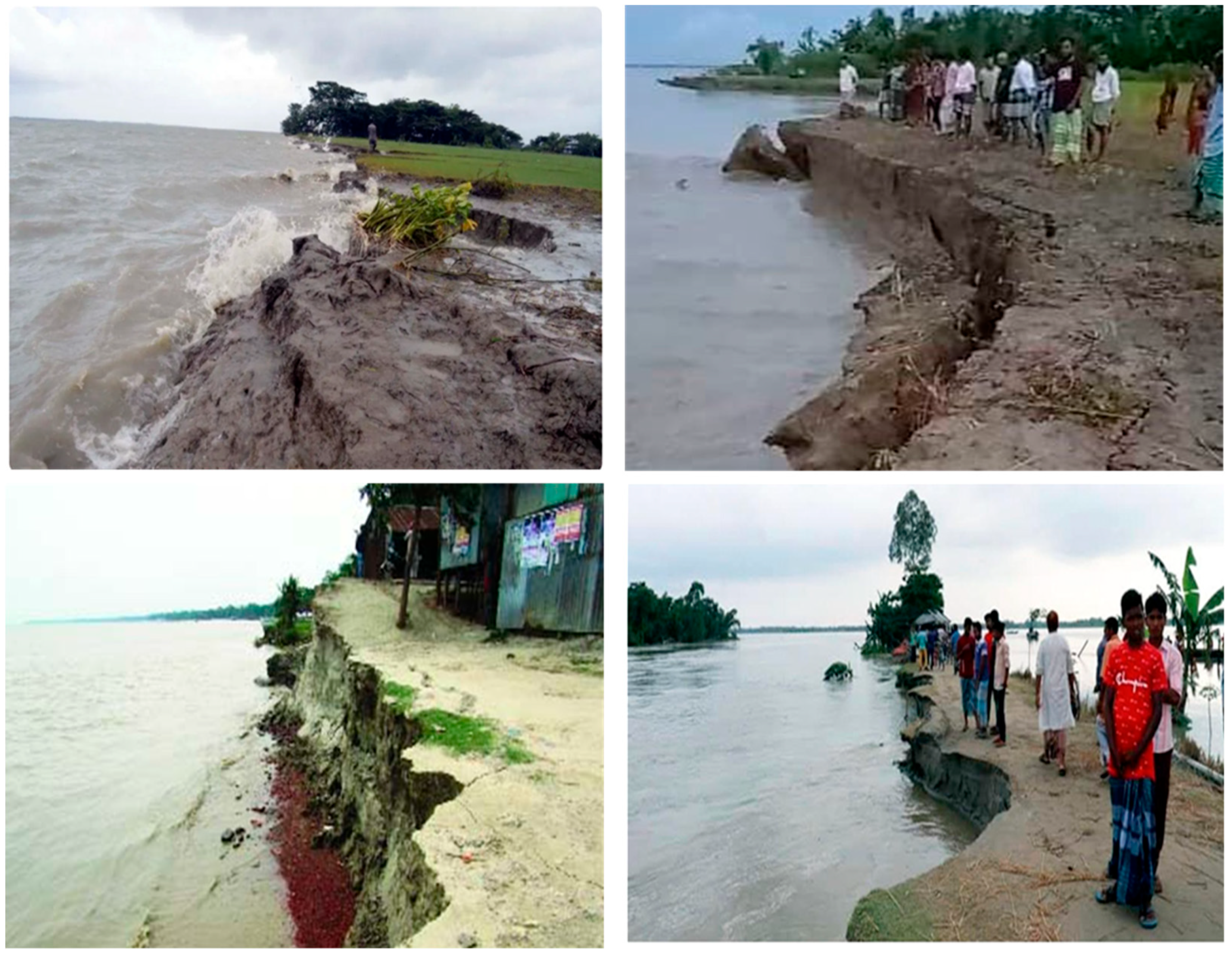
Figure 4.
Demographic information of the respondents.

Figure 5.
Socioeconomic features of the respondents.

Figure 6.
Types of land eroded over the last 20 years in the study area.

Figure 7.
Effects of riverbank erosion on the lives and livelihoods of the affected people.


Table 1.
Participants’ experiences of riverbank erosion and their food security status.
| Participants Experience | Response | Percentage |
|---|---|---|
| Experience regarding riverbank erosion | Yes | 96.7 |
| No | 3.3 | |
| Do not know | 0 | |
| Experience regarding their household food security status before riverbank erosion | Secure | 90.0 |
| Not secure | 6.7 | |
| Not sure/do not know | 3.3 |
Table 2.
Household food security status throughout the year.
| Time Period | Answer/Category | Responses (%) |
|---|---|---|
| January to June | Adequate | 53.3 |
| Inadequate | 46.7 | |
| Scarce | 0 | |
| July to December | Adequate | 15.0 |
| Inadequate | 23.3 | |
| Scarce | 61.7 |
Table 3.
The situation of household food insecurity perception.
| Food Insecurity Status | Answer Category | Response (%) |
|---|---|---|
| No | 1.7 |
| Yes | 98.3 | |
| If yes | ||
| Most of the time | 0 | |
| Sometimes | 98.3 | |
| Sudden | 1.7 | |
| No | 100 |
| Yes | 0 | |
| If yes | ||
| Most of the time | - | |
| Sometimes | - | |
| Sudden | - | |
| No | 100 |
| Yes | 0 | |
| If yes | ||
| Most of the time | - | |
| Sometimes | - | |
| Sudden | - | |
Table 4.
Availability of different kinds of food self-produced by the respondents.
| Types of Food | Average Months Covered | Types of Food | Average Months Covered |
|---|---|---|---|
| Rice | 2.55 | Pulse | 0.76 |
| Wheat | 0.38 | Spices | 0.80 |
| Fish | 0.38 | Oil | 0.57 |
| Meat | 0.32 | Fruits | 0.63 |
| Egg | 1.60 | Vegetables | 1.05 |
| Milk | 1.90 | - | - |
Table 5.
Riverbank Erosion Impacts on Household Indicators.
| Items | After Riverbank Erosion (Response %) | Reason | ||
|---|---|---|---|---|
| No Change | Deteriorated | Improved | ||
| Housing condition | 3.3 | 91.7 | 5.0 | I: Business D: Damage to house |
| Occupation opportunities | 3.3 | 88.3 | 8.3 | I: Small business D: Lack of work, loss of agril. land |
| Income of the household | 10.0 | 76.7 | 13.3 | I: Migration to the city D: Shortage of work |
| Education facilities | 0 | 56.7 | 43.3 | I: Migration to the city D: Financial problems, destruction |
| Health facilities | 0 | 58.3 | 41.7 | I: Migration to the city D: Poor health facilities |
| Electricity | 5.0 | 53.3 | 41.7 | I: Expansion of electricity D: Destruction of electricity supply |
| Sources of drinking water | 8.3 | 50.0 | 41.7 | I: Availability of water sources D: Destruction of water sources |
| Sanitary (toilet) conditions | 3.3 | 55.0 | 41.7 | I: Hygienic toilets for use D: Higher population, poor |
| Transport facilities | 5.0 | 33.3 | 61.7 | I: Migration to the city D: Damage to roads |
| Communication facilities | 3.3 | 51.7 | 45.0 | I: Availability of network D: Disruption in communication |
| NGO services | 15.0 | 61.7 | 23.3 | I: Good NGO services D: No food program |
| Institutional credit (banks) | 28.3 | 65.0 | 6.7 | I: Loan from the bank D: Bank not interested |
| Farm Machinery | 21.7 | 76.7 | 1.7 | I: Government-provided D: Need to buy machinery |
| Household assets | 1.7 | 83.3 | 15.0 | I: Increase in income D: Sold |
| Food security condition | 91.7 | 8.3 | - | I: Migration to the city D: Loss of land |
| Availability of labor | 1.7 | 98.3 | 0 | I: No need D: Loss of agricultural land |
| Marketing facilities | 6.7 | 58.3 | 35.0 | I: Coming near the marketplace D: Not necessary |
N.B: I = improved, and D = deteriorated.
Table 6.
Coping strategies of the affected people towards food security.
| Food Security Strategy | Degree of the Responses (%) | |||
|---|---|---|---|---|
| Regularly | Occasionally | Rarely | Not at All | |
| Reducing the amount of food per meal | 5.0 | 8.3 | 10.0 | 76.7 |
| Reducing the number of meals per day | 1.7 | 1.7 | 21.7 | 75.0 |
| Going to bed without food | - | 3.3 | - | 96.7 |
| Relying on less preferred food | 5.0 | 83.3 | 8.3 | 3.3 |
| Reducing the purchase of children’s food | 1.7 | 76.7 | 8.3 | 13.3 |
| Purchasing food on credit | 1.7 | 46.7 | 35.0 | 16.7 |
| Borrowing money from NGOs/Government organizations | 1.7 | 16.7 | 1.7 | 80.0 |
| Borrowing from moneylenders | 6.7 | 15.0 | 3.3 | 75.0 |
| Migrating to a city or another area | 61.7 | 13.3 | - | 25.0 |
| Relying on casual labor for food | 6.7 | 58.3 | 1.7 | 33.3 |
| Selling cattle/livestock | - | 83.3 | - | 16.7 |
| Spending money from savings | 1.7 | 83.3 | 15.0 | |
| Borrowing money or food from | - | 73.3 | 1.7 | 25.0 |
| Selling land and other assets | - | 66.7 | 3.3 | 30.0 |
| Selling labor in advance | - | 8.3 | - | 91.7 |
Note: 3 = Regularly; 2 = Occasionally; 1 = Rarely and 0 = Not at all.
Table 7.
Views of local government representatives, and their plans for the affected people.
| Questions | Response Category | Response (%) | Mean |
|---|---|---|---|
| Are you a local government representative from the riverbank erosion-affected area? | Yes | 85 | - |
| No | 15 | ||
| If yes, how many years have you played a role as a local government representative? | - | - | 9.55 |
| Do you have any food aid programmes to ensure the food security of local people? | Yes | 100 | |
| No | 0 | ||
| If yes, how many affected people are beneficiaries of the programmes? | - | - | 281.8 |
| Have you seen any migration tendency among the people affected by riverbank erosion in your union area? | Yes | 100 | |
| No | 0 | ||
| If yes, how many affected people migrated from your union during the last 5 years? | - | - | 414.75 |
| Do you have action plans to mitigate riverbank erosion in your area? | Yes | 65 |
Table 8.
Some potential action plans to reduce riverbank erosion in the study area.
| Summary of the Respondents’ Views of Action Plans, Benefits and Drawbacks | |
|---|---|
| Action plans | Throwing geo bags |
| Dredging river beds | |
| The setting of cement-concrete (CC) blocks | |
| Benefits of action plans | Saving agricultural land |
| Saving agricultural land | |
| Protecting homestead area | |
| Improving livelihood Status | |
| Protecting schools, health centres, gardens, markets, etc. | |
| Drawbacks of action plans | Limited resources |
| Local representatives are not entitled to implement big projects with huge budgets | |
| Lack of coordination among governmental agencies | |
Disclaimer/Publisher’s Note: The statements, opinions and data contained in all publications are solely those of the individual author(s) and contributor(s) and not of MDPI and/or the editor(s). MDPI and/or the editor(s) disclaim responsibility for any injury to people or property resulting from any ideas, methods, instructions or products referred to in the content. |
© 2023 by the authors. Licensee MDPI, Basel, Switzerland. This article is an open access article distributed under the terms and conditions of the Creative Commons Attribution (CC BY) license (https://creativecommons.org/licenses/by/4.0/).
Share and Cite
MDPI and ACS Style
Billah, M.M.; Majumdar, A.; Rahman, S.M.A.; Alam, M.S.; Hossain, M.J.; Talukder, J.; Islam, M.M.; Khanam, T. Riverbank Erosion and Rural Food Security in Bangladesh. World 2023, 4, 528-544. https://doi.org/10.3390/world4030033
AMA Style
Billah MM, Majumdar A, Rahman SMA, Alam MS, Hossain MJ, Talukder J, Islam MM, Khanam T. Riverbank Erosion and Rural Food Security in Bangladesh. World. 2023; 4(3):528-544. https://doi.org/10.3390/world4030033
Chicago/Turabian StyleBillah, Md Masum, Abahan Majumdar, Syed Mohammad Aminur Rahman, Mohammad Shah Alam, Md Jamal Hossain, Joynulalom Talukder, Md Mohidul Islam, and Tahmida Khanam. 2023. "Riverbank Erosion and Rural Food Security in Bangladesh" World 4, no. 3: 528-544. https://doi.org/10.3390/world4030033