Brief Report

The Tula Industrial Area Field Experiment: Quantitative Measurements of Formaldehyde, Sulfur Dioxide, and Nitrogen Dioxide Emissions Using Mobile Differential Optical Absorption Spectroscopy Instruments

by
Claudia I. Rivera-Cárdenas
1,* and
Thiare Arellano
2
1
Instituto de Ciencias de la Atmósfera y Cambio Climático, Universidad Nacional Autónoma de México, Mexico City 04510, Mexico
2
Facultad de Química, Universidad Nacional Autónoma de México, Mexico City 04510, Mexico
*
Author to whom correspondence should be addressed.
Pollutants 2024, 4(4), 463-473; https://doi.org/10.3390/pollutants4040031
Submission received: 25 June 2024 / Revised: 16 August 2024 / Accepted: 29 August 2024 / Published: 9 October 2024
(This article belongs to the Section Air Pollution)

Abstract

:
The Tula industrial area in Central Mexico comprises, among other industries, a refinery and a thermoelectric power plant. It is well known for its constant emissions of gases into the atmosphere and considered an important area where pollutants released into the atmosphere have an influence on local and regional air quality. During March and April 2017, a field campaign was conducted with the objective of quantifying formaldehyde (HCHO), sulfur dioxide (SO2), and nitrogen dioxide (NO2) emissions from this industrial area using mobile differential optical absorption spectroscopy (DOAS) instruments. Calculated average emissions of the Francisco Perez Rios Power Plant and the Miguel Hidalgo Refinery were 3.14 ± 2.13 tons per day of HCHO, 362.08 ± 300.14 tons per day of SO2, and 24.76 ± 12.82 tons per day of NO2. From the measurements conducted, the spatial distribution patterns of SO2, NO2, and HCHO were reconstructed, showing a dispersion pattern of SO2 and NO2 towards the southwest of the industrial complex, impacting agricultural and urban areas. Occasionally, and usually during the morning hours, SO2 and NO2 were dispersed towards the north or northeast of the industrial complex. In the case of HCHO, dispersion was observed towards the south and southeast of the industrial complex. The far-reaching implications of this study are that for the first time, formaldehyde emissions were quantified. In addition, a follow-up study was conducted regarding nitrogen dioxide and sulfur dioxide emissions from the Tula Industrial area.

Graphical Abstract

1. Introduction

Fossil fuels are widely used worldwide to generate energy and power transportation, as well as industrial processes. The use of fossil fuels has been steadily increasing over the years, resulting in negative externalities such as the release of pollutants into the air, resulting in air pollution (incurring large social and health costs) and an increase in greenhouse gas emissions, causing climate change and negative effects on ecosystems.
In Mexico, most of the energy production is based on conventional technologies, comprising power plants that use fossil fuels as primary sources for the generation of electricity and, generally, without gasses or particulate matter capture and confinement equipment. These power plants can meet basic demand, in the cases of combined cycle power plants, or, in some cases, peak demand, in the case of turbo gas plants [1].

1.1. The Tula Industrial Area

The two main sources of emissions into the atmosphere located at the Tula industrial area are the Miguel Hidalgo refinery and the Francisco Perez Rios power plant (Figure 1).
The total population of Tula de Allende in 2020 was 115,107 inhabitants, 51.7% of whom were women and 48.3% of whom were men. The age ranges in which the largest population were found were 15 to 19 years (9379 inhabitants), 10 to 14 years (9315 inhabitants), and 5 to 9 years (9228 inhabitants). Between them, they included 24.3% of the total population. In 2020, 26.2% of the population was in a situation of moderate poverty and 1.61% in a situation of extreme poverty. The population that was vulnerable due to social deficiencies reached 37%, while the population that was vulnerable due to income was 5.89%. The main social deficiencies in Tula de Allende in 2020 were lack of access to social security, lack of access to health services, and lack of access to food [2].
Although the operation of both industries (the Miguel Hidalgo refinery and the Francisco Perez Rios power plant) has brought economic benefits to the area, it has also resulted in externalities, such as the release of gas emissions to the atmosphere, which are known to produce respiratory diseases, eye irritation, and skin discomfort, among other effects [3]. In addition, the released gases can cause acid rain or can be deposited in dry form on the ground. Over time, they are dragged to different parts of the area, damaging the ecosystem, as well as into structures such as houses, sculptures, emblematic buildings, etc.
The construction of the Miguel Hidalgo Refinery began in 1972, and it was inaugurated four years later, on 18 March 1976. In that first stage, it had a refining capacity of 150,000 barrels per day [4], and in the latest statistical yearbook (for 2020), a refining capacity of processing 612,000 barrels per day was reported [5]. In 2012, Almanza et al. [6] studied soot and SO2 contributions from elevated flares in the Tula Refinery to urban, suburban, and rural measurement sites as part of the Megacity Initiative: Local and Global Research Observations (MILAGRO) field campaign. Their results suggest a contribution of Tula flaring activities to the total SO2 levels of 18% to 27% at the studied urban site and of 10% to 18% at the suburban studied site. For soot, their model predicted low contribution at the urban, suburban, and rural measurement sites, with less than 0.1% at the three sites.
Tula’s Francisco Pérez Ríos thermoelectric power plant is a parastatal company of the Ministry of Energy that began its activities in 1975 and is currently operated by the Federal Electricity Commission. It has an installed capacity of 2095 GW and mainly supplies the electricity demand for central Mexico. It currently has five conventional steam electricity generating units and uses fuel from both natural gas and fuel oil; however, due to the use of fossil fuel with a high sulfur content (4% by weight), it represents one of the main sources of emission of sulfur dioxide in the region [7,8,9]. The thermoelectric power plant is part of the Regional Central Production Management, it is considered one of the main sources of electricity generation in the country, and it is part of the National Interconnected System which supplies energy to the Mexico City Metropolitan Area [10]. In 2020, Sosa et al. [11] conducted a study analyzing the possible reduction in atmospheric emissions due to switching from fuel oil to natural gas at this power plant. Their modelling results indicated that emissions reductions of >99% for SO2, PM, and Pb, as well as reductions of >50% for organic and inorganic toxins, would be possible if natural gas was used instead of fuel oil.

1.2. Sulfur Dioxide (SO2), Nitrogen Dioxide (NO2), and Formaldehyde (HCHO) Emissions and Their Relevance

The main source of SO2 emissions in the Tula industrial area is the combustion of fossil fuels used by the refinery and power plant. At least 90% of the sulfur present in fossil fuels is emitted as SO2 during combustion processes. In general terms, most of the sulfur emissions to the atmosphere originate from anthropogenic sources, and the combustion of fuel to produce electricity is the main contributor [12].
NO2 is an important and highly reactive gas that is also emitted by the Tula industrial area. NO2 is found mainly in the air due to the burning of fuel. NO2 comes from the emissions of transport vehicles (cars, trucks, and buses), power plants, and all-terrain equipment. NO2 and other NOx interact with water, oxygen, and other chemicals in the atmosphere to form acid rain. For its part, acid rain damages sensitive ecosystems such as lakes and forests, irreparably affecting the flora and fauna in them [12].
HCHO is a common volatile organic compound. It can be naturally produced by vegetation or emitted by human activities, including industrial processes [13]. Several studies demonstrate that HCHO is genotoxic [14], with the possibility to cause gene mutations in mammalian and bacterial cells [15].

2. Methodology

2.1. Mobile Mini-DOAS Measurements

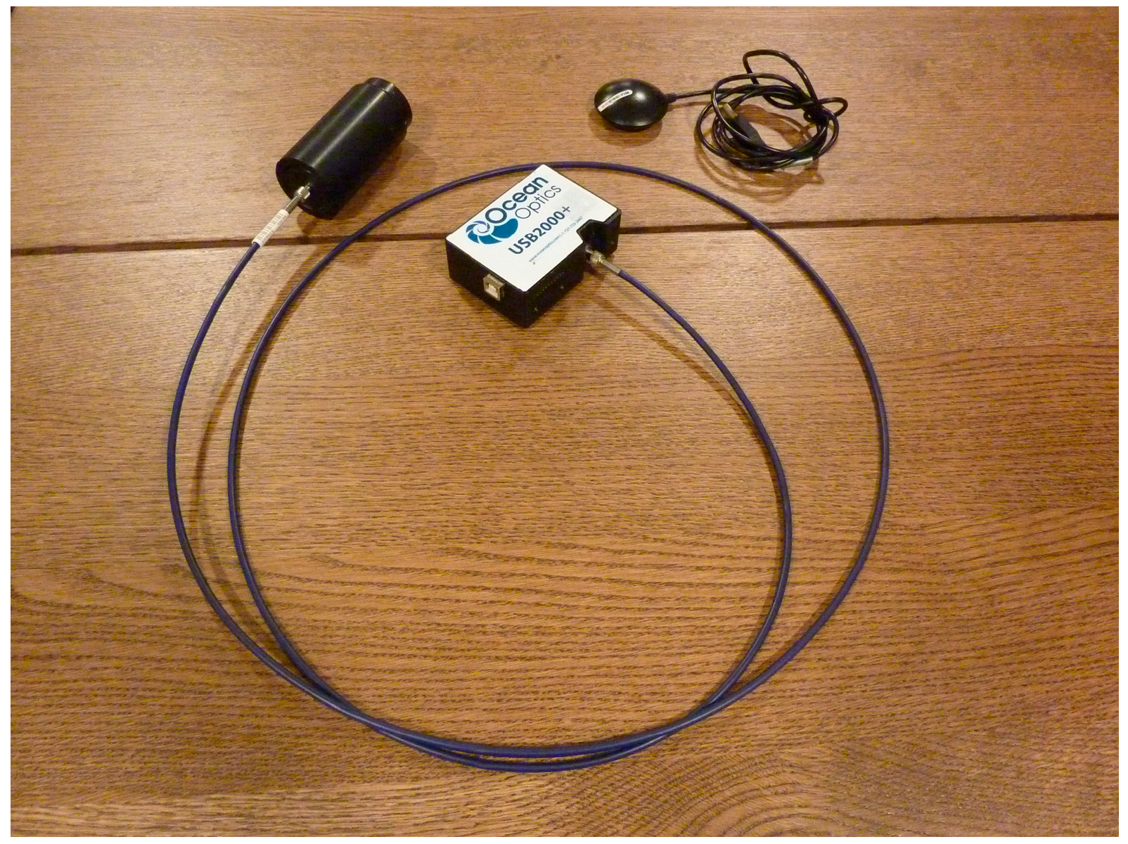
Mobile mini-DOAS instruments collect scattered UV and visible sunlight with a telescope positioned in the zenith position. The telescope is coupled to an optical fiber which transfers the light to a spectrometer which covers a wavelength range where the species of interest absorb. Additionally, a global positioning system (GPS) is used to collect time, latitude, longitude, and altitude of each measurement (Figure 2).
The spectrometer and GPS system are connected to a laptop and controlled by the mobile DOAS software version 5.0 [16] which collects and evaluates the acquired spectra in real time. Further details about the instrument can be found in [17].
Typically, mobile mini-DOAS instruments are installed on a mobile platform while traversing underneath the plume of pollutants released from the sites of interest. SO2, NO2, and HCHO emissions are determined by integrating the total number of molecules in a vertical cross-section of the gas plume and multiplying them by the wind speed at plume height. The mobile mini-DOAS instruments used in this study were mounted on a car, and spectra were recorded at different distances and positions from the source, both encircling the source and traversing downwind from the plume of pollutants.
Collected spectra were postprocessed using the QDOAS software version 3.2 [18]. SO2 was retrieved in the 307–317 nm wavelength range, including a SO2 cross section at 298 K [19], an O3 cross section at 223 K [20], and a ring spectrum. NO2 was retrieved in the 405–465 nm wavelength range, including a NO2 cross section at 294 K [21], an O3 cross section at 223 K [20], an O4 cross section [22], a H2O cross section [23], and a ring spectrum. HCHO was retrieved in the 336.5–359 nm wavelength range, including a HCHO cross-section at 297 K [24], an O4 cross section at 293 K [25], a NO2 cross section at 294 K [21], two O3 cross-sections at 223 K and 243 K [26], a BrO cross-section at 223 K [27], and a ring spectrum.

2.2. Wind Data

Wind speed and direction were downloaded from the Air Resources Laboratory (ARL) Archived Meteorology webpage [28]. In the ARL portal, the latitude and longitude of the study area was provided and a sounding using the Global Data Assimilation System (GDAS) global model; one-degree spatial resolution was generated for each measurement day. From the sounding results, wind speed and wind direction at plume height were obtained and used for fluxes calculations.

2.3. Tula Monitoring Network

The state of Hidalgo has a monitoring network comprising 10 stations located throughout the state. The stations form part of the Air Quality Monitoring System (AQMS) run by Hidalgo state. The AQMS is composed of an organized set of human, technical, and administrative resources employed to operate one or a set of monitoring and/or sampling stations that measure air quality in an area or region. In this study, data from the monitoring station located at the Health Clinic in Tula, Hidalgo, were used. This monitoring station automatically measures wind speed, wind direction, temperature, humidity, atmospheric pressure, UVA radiation, UVB radiation, ozone, nitric oxide, nitrogen dioxide, nitrogen oxides, carbon monoxide, sulfur dioxide, PM10, and PM2.5 [29]. This station was chosen because it is the closest one to the two point sources characterized in this study. The location of the station is presented in Figure 1 and Figure 3.

3. Results and Discussion

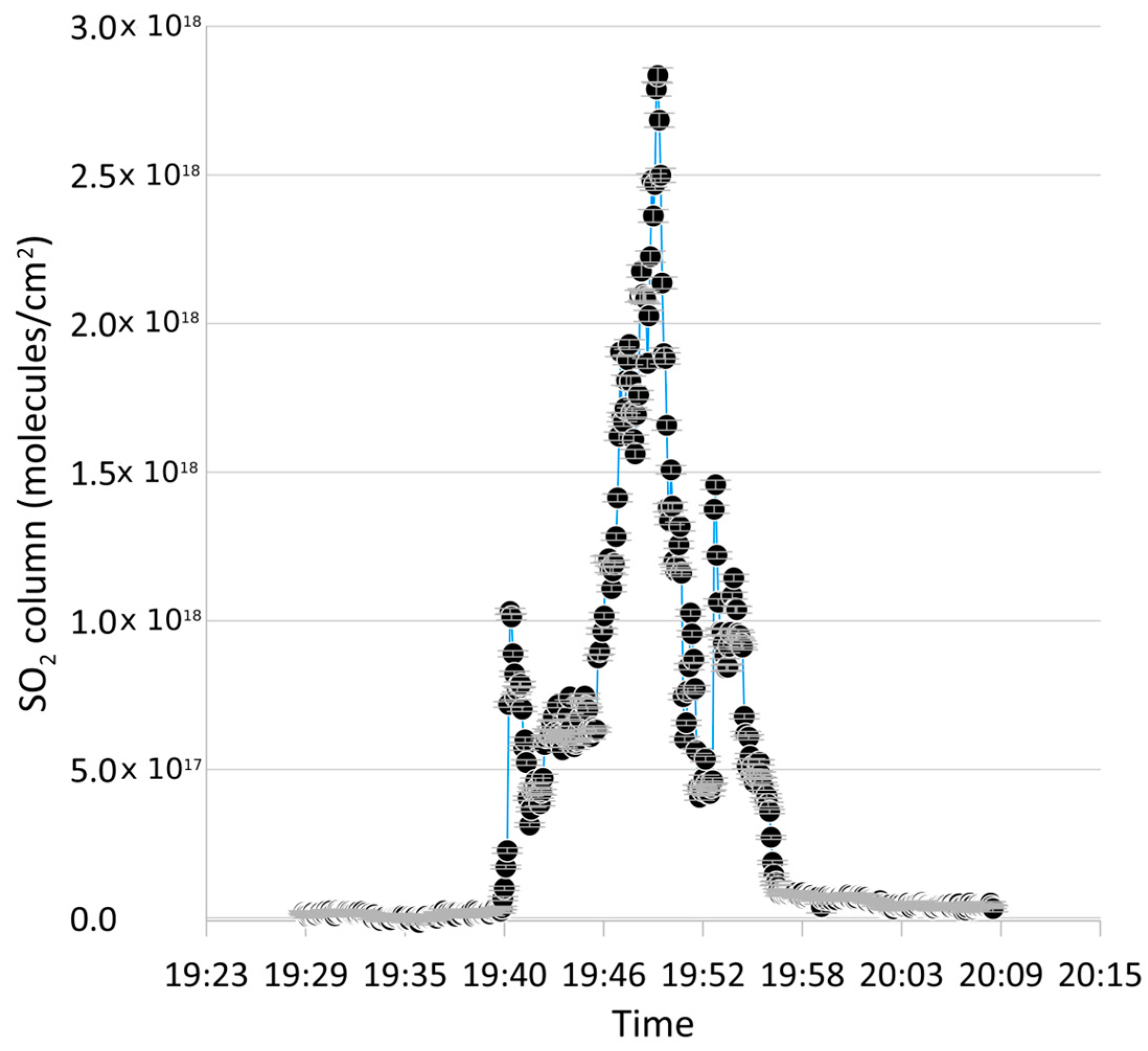
An example of a measurement conducted surrounding the Miguel Hidalgo refinery and the Francisco Perez Rios power plant on 17 March between 19:30 and 20:11 UTC (13:30 and 20:11 Local Time) is presented in Figure 3. Figure 4 shows SO2 columns quantified during the same measurement. The peak value of the SO2 column corresponds to the largest value recorded during the measurement sequence and coincides with the highest NO2 column measured as well.
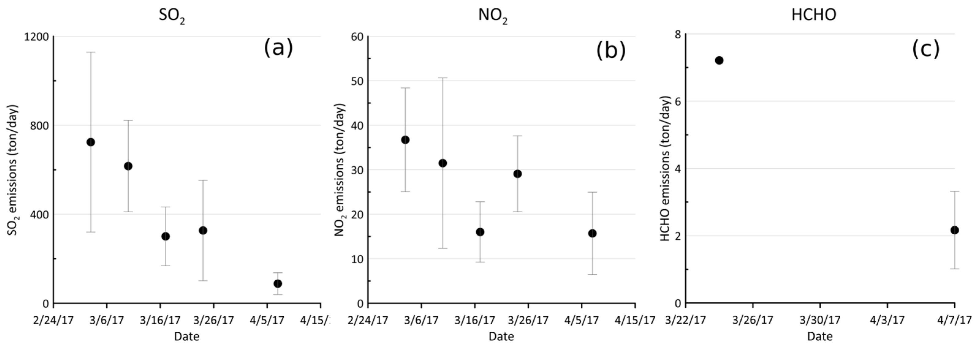
A summary of the SO2, NO2, and HCHO daily results from measurements conducted during the field campaign is presented in Table 1. Figure 5 shows the average and standard deviation of our daily measurements. Large variations in SO2, NO2, and HCHO were measured during different days of the field campaign, which are attributed to changes in activity in both the refinery and the power plant. HCHO was only quantified during two days of the field campaign (24 March and 7 April 2017), while SO2 and NO2 were quantified every day.
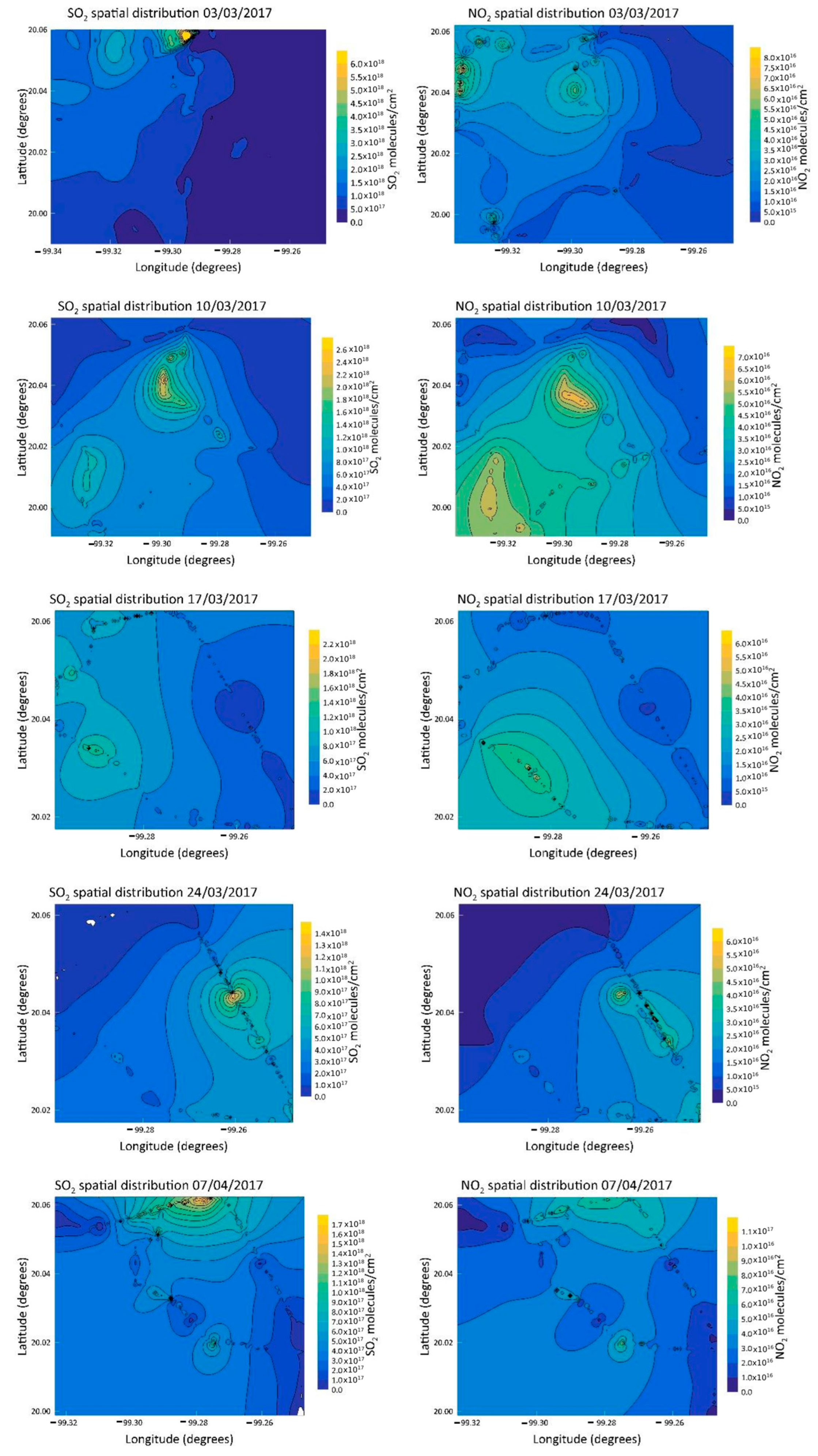
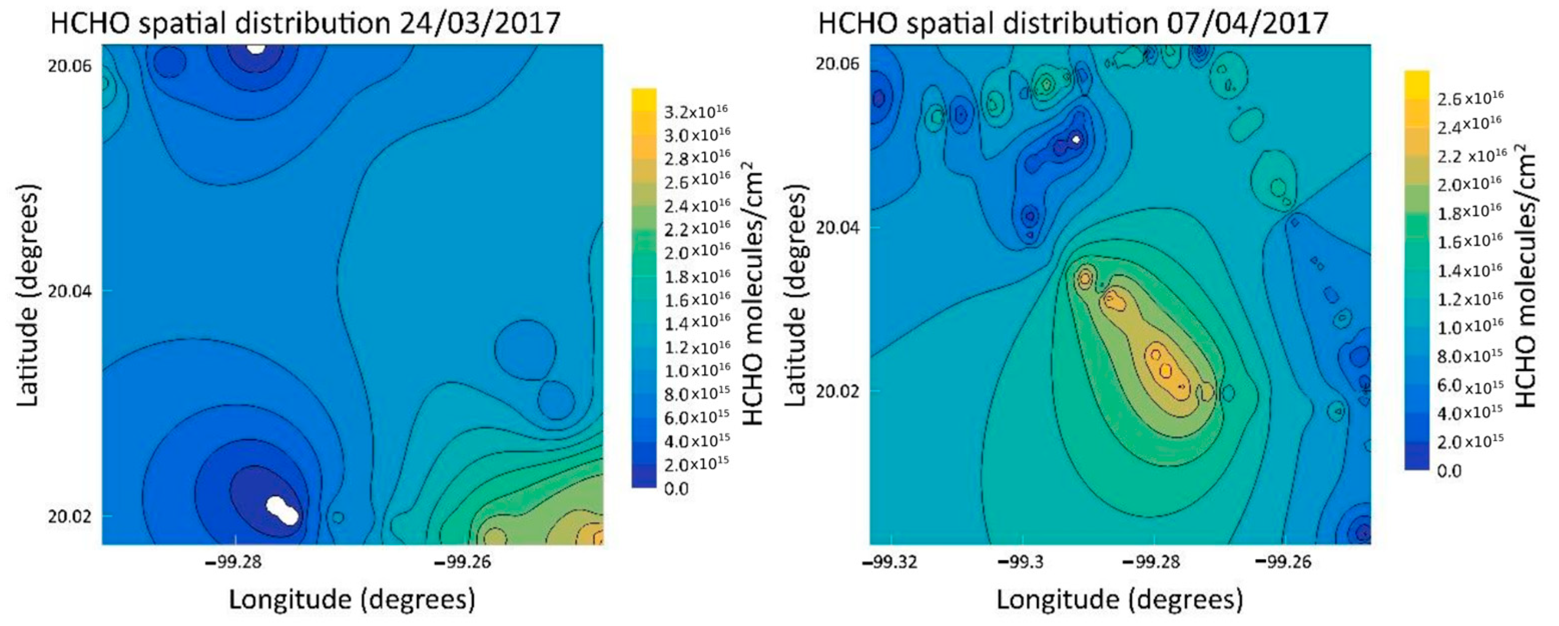
On average, calculated emissions of the Francisco Perez Rios Power Plant and the Miguel Hidalgo Refinery were 3.14 ± 2.13 tons per day of HCHO, 362.08 ± 300.14 tons per day of SO2, and 24.76 ± 12.82 tons per day of NO2. The spatial distribution of SO2 and NO2 is presented in Figure 6. For most of the measurement days, both species exhibited a dispersion pattern towards the southwest of the industrial complex, directly affecting agricultural areas located immediately downwind of the refinery and power plant, as well as some urban areas. Occasionally, and usually during the morning hours, SO2 and NO2 were dispersed towards the north or northeast of the industrial complex. Figure 7 depicts the spatial distribution of HCHO during the two days when it was possible to quantify this molecule. The dispersion of the pollutants was caused by local winds blowing towards the southwest of the industrial complex. Occasionally, and usually during the morning hours, local winds dispersed pollutants towards the north or northeast of the industrial complex; however, in the case of HCHO, dispersion was observed towards the south and southeast of the industrial complex.
The results obtained from this field experiment were compared to previous research conducted in 2006 by Rivera et al. [30], when it was reported that the emissions released by the industrial zone were 384 ± 103 tons per day of SO2 and 24 ± 7 tons per day of NO2. In general and on average, SO2 emissions have decreased between 2006 and 2017, and NO2 emissions have been maintained. Regarding distribution patterns, de Foy et al. [31] reported in 2009 that the Tula industrial area can contribute to the SO2 levels observed in the Mexico City Metropolitan Area (MCMA). Using modeling, the authors determined that a combination of observations (both ground-based and space-borne) and meteorological models can be useful in identifying sources and transport processes of pollutant plumes.
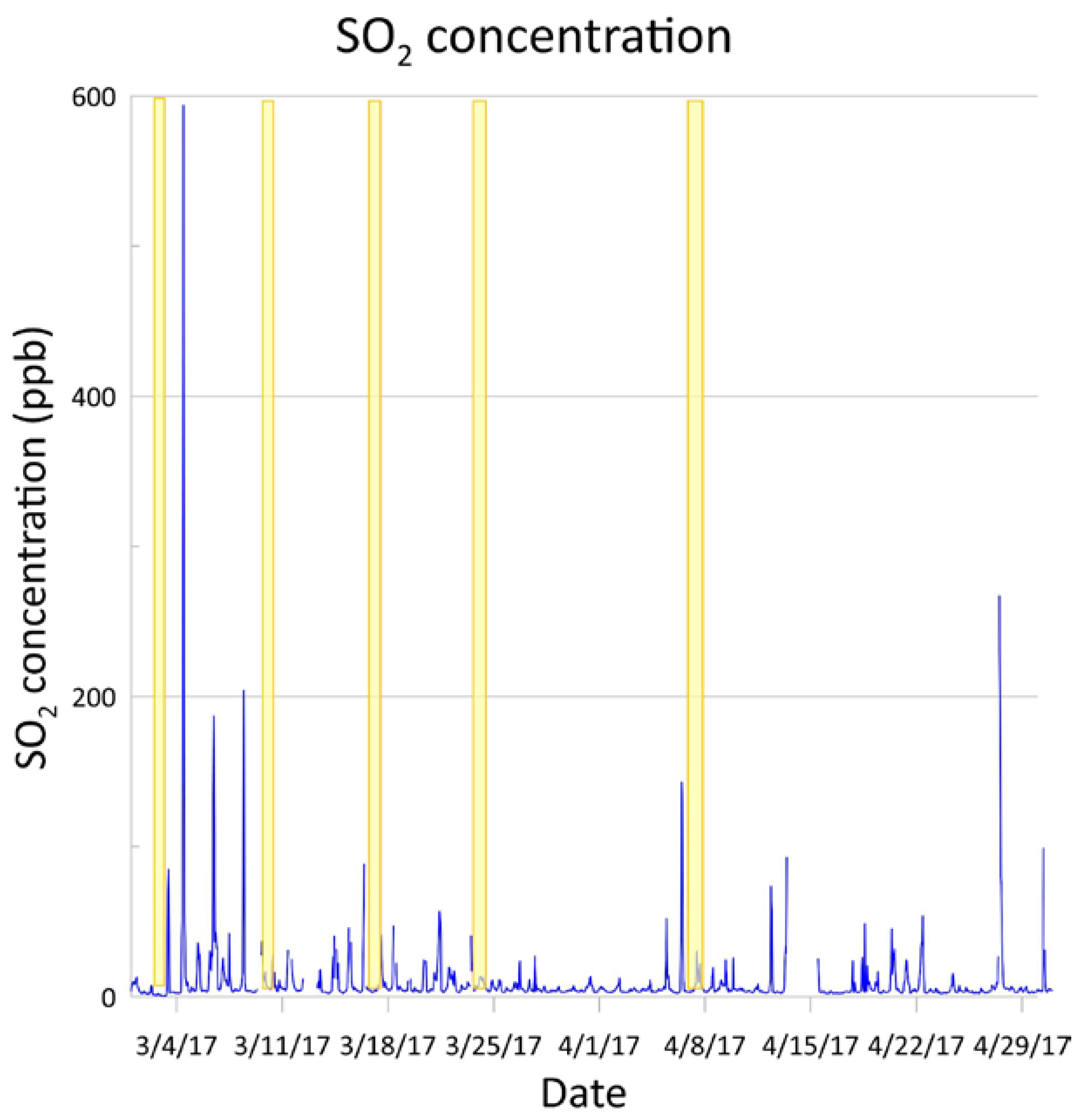
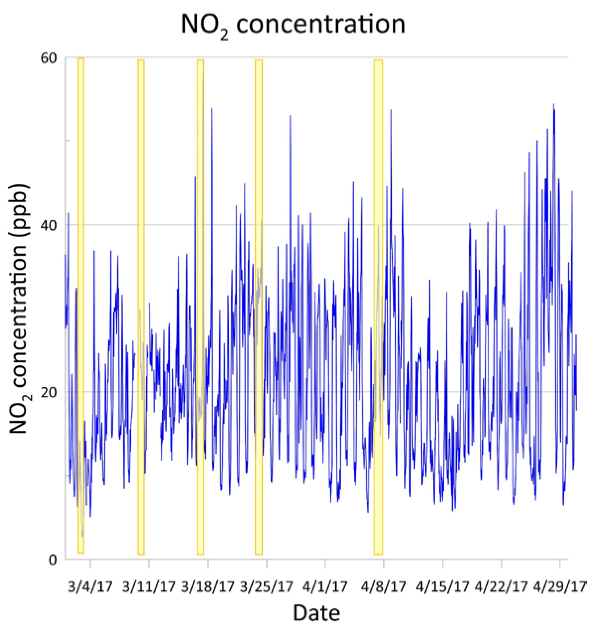
To complement our study, the concentrations of SO2 and NO2 reported by the monitoring station located at the Health Clinic in Tula, Hidalgo, during March and April 2017 are presented in Figure 8 and Figure 9, respectively. During those two months, some peaks showing considerable increases in SO2 can be observed. In the period of time that our measurements lasted, average SO2 concentrations were 10.23 ppb during 3 March, 8.10 ppb during 10 March, 9.34 ppb during 17 March, 8.15 ppb during 24 March, and 8.8 ppb during 7 April. In the case of NO2, average concentrations were 8.99 ppb during 3 March, 19.94 ppb during 10 March, 21.93 ppb during 17 March, 25.95 ppb during 24 March, and 25.45 ppb during 7 April.

4. Conclusions

Between March and April 2017, measurements were conducted at the Francisco Perez Rios Power Plant and the Miguel Hidalgo Refinery located in Tula, Hidalgo. The calculated average emissions of this industrial complex were 362.08 ± 300.14 tons per day of SO2, 24.76 ± 12.82 tons per day of NO2, and 3.14 ± 2.13 tons per day of HCHO. To our knowledge, this is the first time that HCHO emissions from this industrial complex have been reported. Comparing our results with other industrial regions, we can conclude that they are smaller than most of the provincial SO2 emissions reported in China by Huang et al. 2018 and by Li et al. 2017 in India [32,33].
Reconstruction of the spatial distribution patterns of SO2, NO2, and HCHO using column measurements was performed. Different dispersion patterns were observed: in the case of SO2 and NO2, a dispersion pattern of both towards the southwest of the industrial complex was identified, impacting agricultural and urban areas. Sporadically and coinciding with the morning hours, SO2 and NO2 were also dispersed towards the north or northeast of the industrial complex. In the case of HCHO, dispersion was observed towards the south and southeast of the industrial complex.
Comparison with previous studies exhibit slight decreasing emissions of SO2, while NO2 emissions have maintained the same levels since 2006. It is of utmost importance to periodically keep emissions of these gases released by this industrial complex under observation, since it is well known that these gases can produce severe damage to living beings and to the planet.

Author Contributions

Conceptualization, C.I.R.-C.; methodology, C.I.R.-C.; formal analysis, C.I.R.-C. and T.A.; investigation, C.I.R.-C. and T.A.; resources, C.I.R.-C.; data curation, C.I.R.-C. and T.A.; writing—original draft preparation, C.I.R.-C. and T.A.; writing—review and editing, C.I.R.-C.; visualization, C.I.R.-C. and T.A.; supervision, C.I.R.-C.; project administration, C.I.R.-C.; funding acquisition, C.I.R.-C. All authors have read and agreed to the published version of the manuscript.

Funding

This research was funded by UNAM-PAPIIT under grant numbers IA100723 and IA100716.

Data Availability Statement

Data will be available upon request.

Acknowledgments

We acknowledge Thomas Danckaert, Caroline Fayt, and Michel van Roozendael for the free use of the QDOAS software version 3.2. We acknowledge the use of SO2 and NO2 concentration data measured at the Centro de Salud monitoring station (located in Tula, Hidalgo) run by the Secretariat of Environment and Natural Resources of the state of Hidalgo.

Conflicts of Interest

The authors declare no conflicts of interest.

References

  1. Ramos-Gutiérrez, L.J.; Montenegro-Fragoso, M. La generación de energía eléctrica en México. Technol. Cienc. Agua 2012, 3, 197–211. [Google Scholar]
  2. Data Mexico. Tula de Allende. Available online: https://www.economia.gob.mx/datamexico/es/profile/geo/tula-de-allende#population (accessed on 6 August 2024).
  3. Air Quality, Energy and Health. Available online: https://www.who.int/teams/environment-climate-change-and-health/air-quality-energy-and-health/health-impacts/exposure-air-pollution (accessed on 6 August 2024).
  4. Álvarez de la Borda, J. Crónica del Petróleo en México de 1863 a Nuestros Días; Petróleos Mexicanos: Mexico City, Mexico, 2006. [Google Scholar]
  5. Petróleos Mexicanos [PEMEX] Anuario Estadístico. Petróleos Mexicanos. 2020. Available online: https://www.pemex.com/ri/Publicaciones/Anuario%20Estadistico%20Archivos/Anuario-Estadistico_2020.pdf (accessed on 28 February 2023).
  6. Almanza, V.H.; Molina, L.T.; Sosa, G. Soot and SO2 contribution to the supersites in the MILAGRO campaign from elevated flares in the Tula Refinery. Atmos. Chem. Phys. 2012, 12, 10583–10599. [Google Scholar] [CrossRef]
  7. Iniciativa Climática de México [ICM] Estudio Sobre la Influencia de la Central Termoeléctrica de Tula, Hidalgo, en la Calidad del Aire Regional. Iniciativa Climática de México. Available online: https://www.iniciativaclimatica.org/wp-content/uploads/2021/05/Termoele%CC%81ctrica-Tula_190521-3-1.pdf (accessed on 28 February 2023).
  8. Secretaría de Medio Ambiente y Recursos Naturales, Instituto Nacional de Ecología y Cambio Climático, Comisión Ambiental de la Megalópolis [SEMARNAT, INECC, CAME] Calidad del Aire en la Cuenca Atmosférica de Tula. Secretaría de Medio Ambiente y Recursos Naturales, Instituto Nacional de Ecología y Cambio Climático, Comisión Ambiental de la Megalópolis. Available online: https://www.gob.mx/cms/uploads/attachment/file/571616/Calidad_del_Aire_Cuenca_Atm_de_Tula-FINAL.pdf (accessed on 28 February 2023).
  9. Sosa, G.; Vega, E.; González-Avalos, E.; Mora, V.; López-Veneroni, D. Air pollutant characterization in Tula industrial corridor, Central Mexico, during the MILAGRO study. Biomed. Res. Int. 2013, 2013, 521728. [Google Scholar] [CrossRef] [PubMed]
  10. Falcón Benítez, A. Análisis de la Repotenciación de la Central Termoeléctrica Francisco Pérez Ríos, de la CFE, con Tecnología IGCC. Master’s Thesis, Universidad Nacional Autónoma de México, Mexico City, Mexico, 2013. [Google Scholar]
  11. Rodolfo Sosa, E.; Elizabeth, V.; Ann, W.; Mónica, J.; Gilberto Fuentes, G.; Elías Granados, H.; Ana Luisa Alarcón, J.; María del Carmen Torres, B.; Pablo Sánchez, A.; Sergio Rosas, A.; et al. Reduction of atmospheric emissions due to switching from fuel oil to natural gas at a power plant in a critical area in Central Mexico. J. Air Waste Manag. Assoc. 2020, 70, 1043–1059. [Google Scholar] [CrossRef] [PubMed]
  12. Finlaysson-Pitts, B.J.; Pitts, J.N. Chemistry of the Upper and Lower Atmosphere. Theory, Experiments and Applications; Academic Press: San Diego, CA, USA, 2000. [Google Scholar]
  13. Rivera Cárdenas, C.; Daniel, A.M. How does nature regulate atmospheric composition?: Formaldehyde removal from air. In Proceedings of the SPIE 11586, Bioinspiration, Biomimetics, and Bioreplication XI, Online, 22 March 2021; Volume 1158609. [Google Scholar] [CrossRef]
  14. Damgård Nielsen, G.; Thor Larsen, S.; Wolfkoff, P. Re-evaluation of the WHO (2010) formaldehyde indoor air quality guideline for cancer risk assessment. Arch. Toxicol. 2017, 91, 35–61. [Google Scholar] [CrossRef] [PubMed]
  15. Kawanishi, M.; Matsuda, T.; Yagi, T. Genotoxicity of formaldehyde: Molecular basis of DNA damage and mutation. Front. Environ. Sci. 2014, 2, 1–8. [Google Scholar] [CrossRef]
  16. Zhang, Y.; Johansson, M.; Norgaard, D. Mobile DOAS Software, version 6.3.1, Optical Remote Sensing Group, Chalmers University of Technology: Gothemburg Sweden, 2021.
  17. Galle, B.; Oppenheimer, C.; Geyer, A.; McConigle, A.J.S.; Edmons, M.; Horrocks, L. A miniaturized ultraviolet spectrometer for remote sensing of SO2 fluxes: A new tool for volcano surveillance. J. Volcanol. Geotherm. Res. 2002, 119, 241–245. [Google Scholar] [CrossRef]
  18. Danckaert, T.; Fayt, C.; van Roozendael, M.; De Smedt, I.; Letocart, V.; Merlaud, A.; Pinardi, G. QDOAS Software User Manual, Version 3.2. September 2017; Belgian Institute for Space Aeronomy. Available online: https://uv-vis.aeronomie.be/software/QDOAS/QDOAS_manual.pdf (accessed on 28 February 2023).
  19. Vandaele, A.C.; Hermans, C.; Fally, S. Fourier transform measurements of SO2 absorption cross sections: II. Temperature dependence in the 29,000–44,000 cm−1 (227–345 nm) region. J. Quant. Spectrosc. Radiat. Transf. 2009, 110, 2115–2126. [Google Scholar] [CrossRef]
  20. Bogumil, K.; Orphal, J.; Homann, T.; Voigt, S.; Spietz, P.; Fleischmann, O.C.; Vogel, A.; Hartmann, M.; Bovensmann, H.; Frerick, J.; et al. Measurements of molecular absorption spectra with the SCIAMACHY pre-flight model: Instrument characterization and reference data for atmospheric remote sensing in the 230–2380 nm region. J. Photochem. Photobiol. A 2003, 157, 167–184. [Google Scholar] [CrossRef]
  21. Vandaele, A.C.; Hermans, C.; Simon, P.; Carleer, M.; Colin, R.; Fally, S.; Mérienne, M.; Jenouvrier, A.; Coquart, B. Measurements of the NO2 absorption cross-section from 42,000 cm−1 to 10,000 cm−1 (238–1000 nm) at 220 K and 294 K. J. Quant. Spectrosc. Radiat. Transf. 1998, 59, 171–184. [Google Scholar] [CrossRef]
  22. Hermans, C.; Vandaele, A.C.; Fally, S.; Carleer, M.; Colin, R.; Coquart, B.; Jenouvrier, A.; Merienne, M.F. Absorption cross-section of the collision-induced bands of oxygen from the UV to the NIR. In Weakly Interacting Molecular Pairs: Unconventional Absorbers of Radiation in the Atmosphere; Camy-Peyret, C., Vigasin, A.A., Eds.; NATO Science Series Springer: Dordrecht, The Netherlands, 2003; Volume 27, pp. 193–202. [Google Scholar] [CrossRef]
  23. Rothman, L.; Gordon, I.; Barber, R.; Dothe, H.; Gamache, R.; Goldman, A.; Perevalov, V.; Tashkun, S.; Tennyson, J. HITEMP, the high-temperature molecular spectroscopic database. J. Quant. Spectrosc. Radiat. Transf. 2010, 111, 2139–2150. [Google Scholar] [CrossRef]
  24. Meller, R.; Moortgat, G.K. Temperature dependence of the absorption cross sections of formaldehyde between 223 and 323 K in the wavelength range 225–375 nm. J. Geophys. Res. 2000, 105, 7089–7101. [Google Scholar] [CrossRef]
  25. Thalman, R.; Volkamer, R. Temperature dependent absorption cross-sections of O2–O2 collision pairs between 340 and 630 nm and at atmospherically relevant pressure. Phys. Chem. Chem. Phys. 2013, 15, 15371–15381. [Google Scholar] [CrossRef] [PubMed]
  26. Serdyuchenko, A.; Gorshelev, V.; Weber, M.; Chehade, W.; Burrows, J.P. High spectral resolution ozone absorption cross-sections—Part 2: Temperature dependence. Atmos. Meas. Tech. 2014, 7, 625–636. [Google Scholar] [CrossRef]
  27. Fleischmann, O.C.; Hartmann, M.; Burrows, J.P.; Orphal, J. New ultraviolet absorption cross-sections of BrO at atmospheric temperatures measured by time-windowing Fourier transform spectroscopy. J. Photochem. Photobiol. A 2004, 168, 117–132. [Google Scholar] [CrossRef]
  28. Air Resources Laboratory Archived Meteorology. National Oceanic and Atmospheric Administration. Available online: https://www.ready.noaa.gov/READYamet.php (accessed on 28 February 2023).
  29. Sistema Nacional de Información de la Calidad del Aire [SINAICA] Red de Monitoreo de Tula, Hidalgo. 2022. Available online: https://sinaica.inecc.gob.mx/ (accessed on 28 February 2023).
  30. Rivera, C.; Sosa, G.; Wöhrnschimmel, H.; de Foy, B.; Johansson, M.; Galle, B. Tula industrial complex (Mexico) emissions of SO2 and NO2 during the MCMA 2006 field campaign using a mobile mini-DOAS system. Atmos. Chem. Phys. 2009, 9, 6351–6361. [Google Scholar] [CrossRef]
  31. de Foy, B.; Krotkov, N.A.; Bei, N.; Herndon, S.C.; Huey, L.G.; Martínez, A.-P.; Ruiz-Suárez, L.G.; Wood, E.C.; Zavala, M.; Molina, L. Hit from both sides: Tracking industrial and volcanic plumes in Mexico City with surface measurements and OMI SO2 retrievals during the MILAGRO field campaign. Atmos. Chem. Phys. 2009, 9, 9599–9617. [Google Scholar] [CrossRef]
  32. Huang, J.-T. Sulfur dioxide (SO2) emissions and government spending on environmental protection in China—Evidence from spatial econometric analysis. J. Clean. Prod. 2018, 175, 431–441. [Google Scholar] [CrossRef]
  33. Li, C.; McLinden, C.; Fioletov, V.; Krotkov, N.; Carn, S.; Joiner, J.; Streets, D.; He, H.; Ren, X.; Li, X.; et al. India is overtaking China as the world’s largest emitter of anthropogenic sulfur dioxide. Sci. Rep. 2017, 7, 14304. [Google Scholar] [CrossRef] [PubMed]
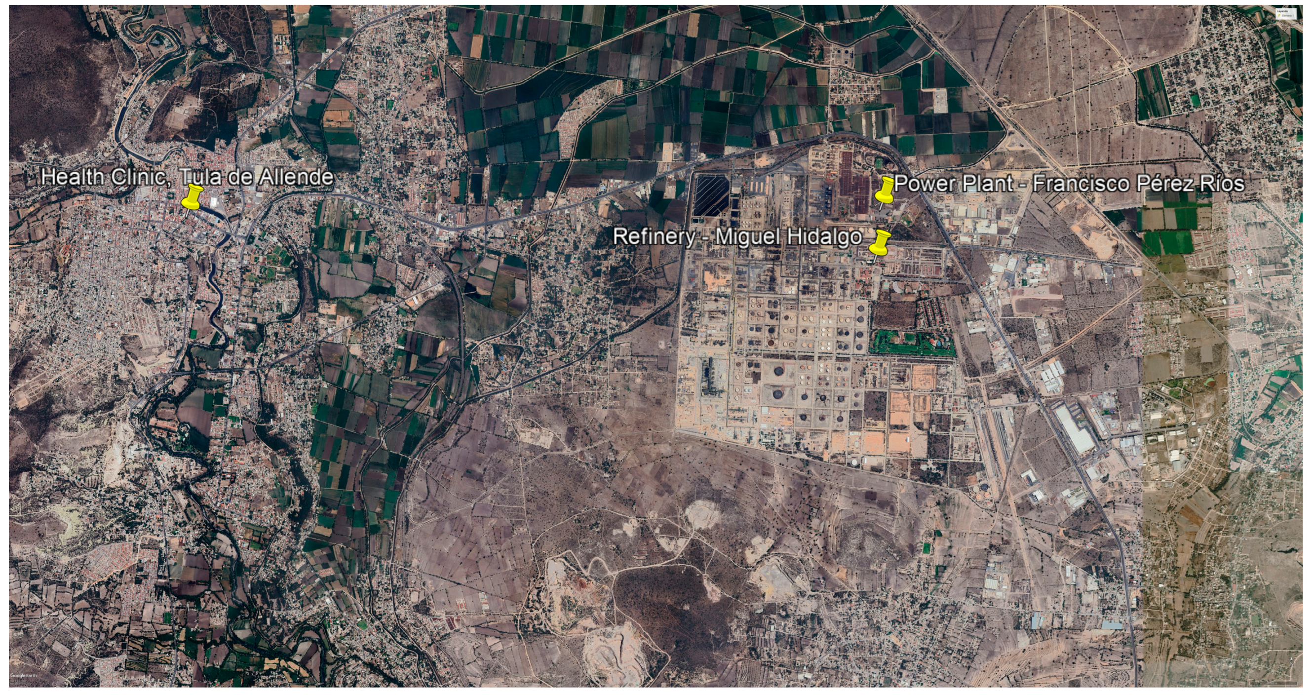
Figure 1. Location of the Miguel Hidalgo refinery, the Francisco Perez Rios power, and the Health Clinic. Images from Google Earth: Image © 2024 CNES/Airbus.
Pollutants 04 00031 g001
Figure 2. Mobile mini-DOAS instrument used in this field campaign.
Pollutants 04 00031 g002
Figure 3. Example of a measurement conducted surrounding the Miguel Hidalgo refinery and the Francisco Perez Rios power plant on 17 March between 19:30 and 20:11 UTC, where SO2 columns are depicted. Images from Google Earth: image © 2022 CNES/Airbus. Image © 2022 Maxar Technologies.
Pollutants 04 00031 g003
Figure 4. SO2 columns quantified during a measurement conducted on 17 March between 19:30 and 20:11 UTC surrounding the Miguel Hidalgo refinery and the Francisco Perez Rios power plant, corresponding to the measurement route presented in Figure 3. Black circles represent SO2 columns quantified from each measured spectrum, while vertical gray lines represent SO2 column errors computed during the retrieval.
Pollutants 04 00031 g004
Figure 5. Daily averages (circles) and standard deviation (vertical lines) of SO2 (a), NO2 (b), and HCHO (c) measurements conducted during the field campaign.
Pollutants 04 00031 g005
Figure 6. Spatial distribution of SO2 (left) and NO2 (right) constructed from measurements conducted during the field campaign. The location of the power plant is 20.054900 N (latitude) and 99.272239 W (longitude), while the location of the refinery is 20.050031 N (latitude) and 99.272838 W (longitude).
Pollutants 04 00031 g006
Figure 7. Spatial distribution of HCHO constructed from measurements conducted during the field campaign. The location of the power plant is 20.054900 N (latitude) and 99.272239 W (longitude), while the location of the refinery is 20.050031 N (latitude) and 99.272838 W (longitude).
Pollutants 04 00031 g007
Figure 8. SO2 concentrations (blue lines) in ppb measured at the Centro de Salud monitoring station located in Tula, Hidalgo. Measurement days with the mini-DOAS technique are shown with vertical yellow lines.
Pollutants 04 00031 g008
Figure 9. NO2 concentrations (blue lines) in ppb measured at the Centro de Salud monitoring station located in Tula, Hidalgo. Measurement days with the mini-DOAS technique are shown with vertical yellow lines.
Pollutants 04 00031 g009
Table 1. Summary of the SO2, NO2 and HCHO daily results from measurements conducted during the field campaign.
DateSO2NO2HCHO
Flux Emissions (t/d)Stdev
(t/d)
No. of MeasurementsFlux Emissions (t/d)Stdev
(t/d)
No. of MeasurementsFlux Emissions (t/d)Stdev
(t/d)
No. of Measurements
3 March 17724.18404.49436.7211.654---------
10 March 17616.42205.54431.5019.143---------
17 March 17300.91132.08516.026.794---------
24 March 17327.15225.83729.098.5277.21N/A1
7 April 1788.4648.77715.709.2672.171.155
Disclaimer/Publisher’s Note: The statements, opinions and data contained in all publications are solely those of the individual author(s) and contributor(s) and not of MDPI and/or the editor(s). MDPI and/or the editor(s) disclaim responsibility for any injury to people or property resulting from any ideas, methods, instructions or products referred to in the content.