Abstract
The ever-increasing world’s population, the consequent heavy demand for food supply, and the lack of rain-fed agriculture to meet such demands have increased the role of irrigation in agricultural production. Water management in the irrigation system is the biggest problem, particularly in regions where the effects of climate change are noticeable. The amount and timing of the crop’s water requirements are under debate. Information about crops, weather, and/or soil is needed for this purpose. Unfortunately, getting such information is difficult, especially when working with enormous tracts of property. Scientists have been working to find the answers to these issues for many years. The use of remote sensing to gather the necessary data is one area that has attracted interest. The advantage of remote sensing is that data collection over vast distances becomes simple and efficient. For the purpose of enhancing sustainability, crop yield, and environmental quality, precision agriculture involves the use of agronomic concepts and innovative technology to control the geographical and temporal variance related to every aspect of agricultural output. Crop water status is monitored in agricultural areas using a variety of remote sensing techniques. It mainly includes remote sensing, crop monitoring in terms of water management, the use of drones, and modern irrigation techniques for the purpose of saving water and increasing water use efficiency in crops. This review is focused on remote sensing technologies for precision irrigation used to calculate evapotranspiration, infrared thermography, crop water status, and crop attributes. The framework for achieving this goal has included precision agriculture as a valuable element. By using these techniques, we can overcome the problem of water shortage, which is crucial for agriculture.
1. Introduction
Precision farming is at the center of offering solutions to the industry’s major issues. Precision agriculture is defined as the “application of technologies that integrate sensors, information systems, improved machinery, and versed management to optimize productivity within sustainable agricultural systems”. The main goals of precision farming include economic viability, environmental protection, and sustainability. It is considered a system that assists in reorganizing the total agricultural system in the direction of sustainable, low-input, and high-efficiency agriculture [1]. However, it is still difficult to determine how much water is needed to run various irrigation management systems for a wide variety of crops. To meet the certain irrigation requirements of each crop field on the farm, irrigation systems are selected, created, and managed through the use of sensors. We must better manage our water resources if we want to produce enough food to fulfill future demands in an era of decreasing water availability. Good information is necessary for management and planning irrigation systems, yet it is currently difficult to find credible information on how to use water resources. It is not a simple task to provide accurate information at scales ranging from farmer fields complete river basins, including millions of hectares of irrigated land. However, general information about the agricultural and hydrological characteristics of the land surface may be obtained for large areas using space-borne remote sensing measures [2]. During the last 20 years, there have been significant advancements in the ability of remote sensing applications to recognize and monitor crop growth and other associated biophysical characteristics; however, there are still a number of problems that need to be fixed. Depending on the capabilities of data gathering and analysis, remote sensing techniques are now recognized as efficient and effective measurements for irrigation water management [3]. The development of technologies such as remote sensing, mobile computing, telemetry, and satellite monitoring has greatly aided the solution of the water management problem [4]. For various crops, it is crucial to maintain a powerful connection between farm water conditions and crop production [5]. The exercise of remote sensing techniques has significantly enhanced the characterization of surface water bodies, the forecasting of rainfall and temperature, the estimation of soil moisture, soil surface characteristics, and evapotranspiration. With the use of high-resolution satellite data, it is now feasible to monitor flood, drought, and irrigation management events in close to real time [5].
2. Remote Sensing for Water Management
Remote sensing systems employing information and communication technologies generally produce enormous amounts of spectrum data due to the high spatial, temporal, and radiometric resolutions necessary for applications in precision agriculture [6].
2.1. Remote Sensors
Modern agriculture is increasingly relying on the remote sensors for improved crop production with the efficient use of resources. The energy released by crops is calculated by thermal infrared sensors to determine the temperature, which is used to determine the irrigation needs and crop water shortages. Microwave sensors operate similarly to thermal sensors in order to measure the estimated energy from the ground surface. These are mostly utilized for large-scale irrigation of crops and soil moisture measurements [7]. A unique sustainable agriculture method enables the supply of water to the plant in small, regulated dosages at the proper times and locations to ensure the best possible growing circumstances [7].
2.2. Modern Irrigation Technology
A crucial component in adjusting the water needs of crops is the use of sensors to monitor crop water status. Numerous soil scientists see soil variables, such as soil water content, as an essential component of scheduling tools for regulating irrigation [8]. For checking or detecting the water content in a soil network of wireless sensors, various mobile applications and software were built. The design of wireless sensor networks was created, and the new irrigation management system was developed using this network as a basis. With the assistance of data analysts, the irrigation test is achieved by using real-time moisture data and expert data. The smart irrigation technologies include monitoring devices and different types of sensors, such as some mobile applications, temperature sensors, and soil moisture sensors, as shown in Figure 1. This technology is considered effective and practicable for use in the fields of precision agriculture and sustainable water resources.
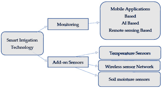
Figure 1.
Smart Irrigation Technologies.
Nevertheless, water scarcity, inadequate irrigation infrastructure, low water quality, inadequate financial resources, limited farmer involvement in decision-making, and fewer extension services are the main obstacles preventing the development of modern irrigation practices [8]. To improve irrigation management, farmers must monitor data such as soil type, soil pH, soil moisture, and nutrients, to make decisions that reduce agricultural problems. In order to address the complex issues relevant to agriculture, the current methodology and developing technologies must be integrated into a data-driven technology to achieve proper irrigation [8].
2.3. Drones
More recent data may be provided by a drone, which allows for great precision in determining water usage issues that are not seen clearly on the ground level. Therefore, to upgrade crop quality, production, and profitability, precision farming builds on the use of cutting-edge technologies, including field mapping and satellite imaging. Additionally, it makes the best use of conventional resources. Huang [6] created a cutting-edge drone with an infrared camera to examine the agricultural area and illustrate the difference between healthy and infected crops [8]. Drone surveillance of greenhouses can boost agricultural production by detecting insect assaults earlier, which lowers the trip expenses over extremely vast distances and fixes any irrigation problems found on the farm. Additionally, drones and intelligent sensors might be used to provide an effective tool for agriculture in the future.
3. Conclusions
There is unquestionably a need for better management of the world’s agricultural resources, such as water, due to the growing population pressure and the requirement for enhanced agricultural production. To accomplish this, it is important to gather trustworthy information on the types, quality, amount, and locations of water resources. Remote sensing technology is a crucial instrument for enhancing the current system of collecting and producing data on agriculture and natural resources. The ability to schedule irrigation and assess the effectiveness of irrigation systems using data received from remote sensing makes it a significant tool in irrigation water management. Since irrigation plays a significant role in agricultural output, the new emerging technologies of remote sensing and modern irrigation techniques will prove to be very fruitful for water management in vast irrigation systems and enhancing the water use efficiency of crops.
Author Contributions
Conceptualization, guiding and improving the article, T.S.; writing the original draft, M.A. and M.T.B.; conceptualization, drafting and revising the article S.K., M.Z.N. and S.-T.-M. All authors have read and agreed to the published version of the manuscript.
Funding
This research received no external funding.
Institutional Review Board Statement
Not applicable.
Informed Consent Statement
Not applicable.
Data Availability Statement
No datasets were generated or analyzed for this article.
Acknowledgments
The authors are thankful to organizing team of the First International Precision Agriculture Pakistan conference held on 22–24 September 2022.
Conflicts of Interest
The authors declare no conflict of interest.
References
- Bonfante, A.; Sellami, M.H.; Abi Saab, M.T.; Albrizio, R.; Basile, A.; Fahed, S.; Bouma, J. The role of soils in the analysis of potential agricultural production: A case study in Lebanon. Agric. Syst. 2017, 156, 67–75. [Google Scholar] [CrossRef]
- Garrido-Rubio, J.; Calera, A.; Arellano, I.; Belmonte, M.; Fraile, L.; Ortega, T.; González-Piqueras, J. Evaluation of remote sensing-based irrigation water accounting at river basin district management scale. Remote. Sens. 2020, 12, 3187. [Google Scholar] [CrossRef]
- Kanda, E.K.; Lutta, V.O. The status and challenges of a modern irrigation system in Kenya: A systematic review. Irrig. Drain. 2022, 71, 27–38. [Google Scholar] [CrossRef]
- Conrad, C.; Usman, M.; Morper-Busch, L.; Schönbrodt-Stitt, S. Remote sensing-based assessments of land use, soil and vegetation status, crop production and water use in irrigation systems of the Aral Sea Basin. A review. Water Secur. 2021, 11, 100078. [Google Scholar] [CrossRef]
- Alvino, A.; Marino, S. Remote sensing for irrigation of horticultural crops. Horticulturae 2017, 3, 40. [Google Scholar] [CrossRef]
- Huang, Y.; Chen, Z.X.; Tao, Y.U.; Huang, X.Z.; Gu, X.F. Agricultural remote sensing big data: Management and applications. J. Integr. Agric. 2018, 17, 1915–1931. [Google Scholar] [CrossRef]
- Garrido-Rubio, J.; Gonzalez-Piqueras, J.; Campos, I.; Osann, A.; Gonzalez-Gomez, L.; Calera, A. Remote sensing–based soil water balance for irrigation water accounting at plot and water user association management scale. Agric. Water Manag. 2020, 238, 106236. [Google Scholar] [CrossRef]
- Abdelhaleem, F.S.; Basiouny, M.; Ashour, E.; Mahmoud, A. Application of remote sensing and geographic information systems in irrigation water management under water scarcity conditions in Fayoum, Egypt. J. Environ. Manag. 2021, 299, 113683. [Google Scholar] [CrossRef] [PubMed]

Disclaimer/Publisher’s Note: The statements, opinions and data contained in all publications are solely those of the individual author(s) and contributor(s) and not of MDPI and/or the editor(s). MDPI and/or the editor(s) disclaim responsibility for any injury to people or property resulting from any ideas, methods, instructions or products referred to in the content. |
© 2023 by the authors. Licensee MDPI, Basel, Switzerland. This article is an open access article distributed under the terms and conditions of the Creative Commons Attribution (CC BY) license (https://creativecommons.org/licenses/by/4.0/).