Abstract
The Brazilian Cerrado biome provides relevant ecosystem services for Brazil and South America, being strategic for the planning and management of water resources as well as for agribusiness. The objective was to evaluate the water quality along the course of the Córrego da Formiga in a virgin portion of the Brazilian Cerrado, the relationship of land use with physical-chemical and biological parameters of the water, and the inflow of the tributary. Five water collection points were defined (between the source and mouth) and observed on a quarterly scale in 2015, water samples were collected and analyzed for physical-chemical and biological parameters in the laboratory, and flow measurements were performed at the same point and day of water collection. To identify and quantify land use and land cover (LULC) in the watershed, an image from the Landsat8-OLI satellite was obtained, and other geomorphological data from hypsometry (Topodata-INPE) were obtained to generate the slope, basin delimitation, and contribution area for each water collection point. The LULC percentages for each area of contribution to the water collection points were correlated with the physical-chemical and biological parameters of the water and submitted to multivariate analysis (PLS-DA) for analysis and grouping among the five analyzed points. Changes in water-quality patterns were more pronounced concerning the time when the first and last sampling was performed (rainy period) and may be influenced by the increase in the volume of water in these periods. The stream flow is highly variable over time and between points, with the lowest recorded flow being 0.1 L s−1 (P1) and the highest being 947.80 L s−1 (P5). Córrego da Formiga has class III water quality (CONAMA resolution 357), which characterizes small restrictions on the use of water for multiple uses. The soil cover with native vegetation is just over 12%, while the predominance was of the classes of sugar cane (62.42%) and pasture (19.33%). The PLS-DA analysis allowed separating the water analysis points between P1, P2, P3, and P5, while P4 was superimposed on others. It was also possible to verify that the parameters that weighed the most for this separation of water quality were pH, alkalinity_T, alkalinity_h, calcium, and hardness, all with a tendency to increase concentration from the source (P1) to the mouth (P5). As for water quality, it was also possible to verify that points P2 and P5 presented better water-quality conditions.
1. Introduction
Water is the most important element for life on earth. According to refs. [1,2], in the last 100 years, with the exponential population growth and the exploitation increase of water resources for different purposes, water has become increasingly scarce, and hence, water management policies must be adopted for an efficient use and water conservation.
In Brazil, in spite of the large water volumes stored in the country, water is not an inexhaustible resource, and water management strategies must be adopted for a sustainable use [3]. The National Water Resources Policy-PNRH, Law 9433 of 1997 [4], addresses the water resources management in the country in order to guarantee the multiple water use as well as emphasizes the adoption of the watershed as the geographical element for planning and management of Brazilian waters [5,6,7,8].
In Brazil, water is an abundant resource although presenting an uneven spatial distribution, with regions of the country subject to water scarcity, while other regions present water resources in large quantities [9,10,11,12]. Thus, it ends up becoming a socio-economical problem, threatening life preservation at different regions of the country [13]. In addition, there are limitations to the use and consumption of potable water imposed by the lack in management (e.g., improper disposal of effluents and industrial waste, indiscriminate use in agriculture, and the wastewater effluent discharge), which jeopardize water hydrochemical quality [14,15,16,17].
Multiple water uses in agriculture, public supply, hydropower generation, various industrial uses, tourism, fishing, aquaculture, navigation, mining, health, and economic exploitation practices in a watershed can affect water availability and/or quality [18,19,20,21,22,23]. Among of all these sectors, agriculture stands out in terms of the highest water consumption, mainly for irrigation. Ref. [24] reported that all sectors that use water benefit, from food production to energy generation, from the implementation of sustainable water use and protection policies.
The Cerrado biome provides a variety of ecosystem services such as water provision, climate regulation, and biodiversity conservation for the Brazilian Midwest Plateau [25]. In the region, one of the biggest disputes over water allocation is played by the agricultural sector (region of the largest agricultural hub in the country) as a result of the territorialization of agribusiness [26,27,28]. Thus, it is expected that ongoing land-use changes at the Brazilian Central Plateau can strongly influence the water quality and quantity in its headwaters and springs in near future.
Some scholars highlight the benefits and trade-offs related to ecosystem services policies implementation, with the inclusion of end users in a participatory approach in order to guarantee hydrological protection of headwaters and natural springs [29]. In this sense, The Brazilian National Water and Sanitation Agency (ANA) created the Water Producer Programme (WPP) in the early 2000s, which has been systematically disseminated in the Cerrado region and might progressively reverse the current water-scarcity local scenario if adequately implemented. WPP is a payment for ecosystem services (PES) scheme focusing on the preservation of natural forested areas and afforestation at small watersheds. In spite of the large number of studies addressing water availability and environmental services at the Brazilian Cerrado, there is still a lack of studies focusing on the impact of land-use occupation on the region headwaters.
This study sought to analyze the spatiotemporal variability of streamflow and water quality of the Córrego da Formiga, at the Brazilian Cerrado, and its association with dilution processes, suspended sediments, and climate regimes (e.g., precipitation, temperature, and humidity patterns). Aspects related to the Brazilian Official Standards for water use [30] are also addressed. This resolution classifies Brazilian water bodies for the proper use of water and establishes conditions and standards for effluent disposals.
Hence, this investigation aimed to evaluate the relationship between land-use occupation and water availability at a small headwater watershed at the Brazilian Central Plateau, taking into account physical, chemical, and biological processes in addition to their interconnection to the hydrological regime at the spring. It is expected that the present results could contribute to guidelines towards the sustainable development of the Brazilian Cerrado.
2. Material and Methods
2.1. Study Area Characterization
The work was carried out at Córrego da Formiga Watershed in the southern mesoregion of the Goiás State, Brazil (Figure 1). Monitoring stations have been implemented along the main watercourse, distributed from the head to the river outlet, in the municipality of Quirinópolis. According to the Köppen and Geiger climate classification, the climate is Aw―Savannah, with a dry season in winter [31,32]. The municipality is located 521 m above sea level and has a mean temperature of 24.30 °C with a mean annual rainfall of 1531 mm [33]. The Córrego da Formiga presents permanent preservation areas (APP) along its course, comprising gallery forests and Cerrado vegetation totaling an area of 582,536 ha of native vegetation [34].
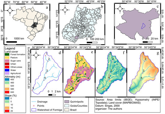
Figure 1.
Geographic location of the study region: Brazil (a), State of Goias (b), Córrego da Formiga watershed in the municipality of Quirinópolis (c), drainage and water collection points (d), land use and cover (e), terrain slope (f), and altimetry (g).
The Córrego da Formiga is located more specifically in the Confusão do Rio Preto micro-region, which represents an important economic region of Quirinópolis. The main water uses from the watershed are basically for domestic, agricultural, animal watering, and aquaculture use.
2.2. Land-Use and -Cover (LULC) Mapping
Land-use and land-cover data for the study region, for the year 2015, was obtained through the geographic base available on the MapBiomas [34]. The region and land-use product were selected and downloaded. Data are available in raster form (30 m × 30 m) from the processing of Landsat-8 images and were cut to the area of interest and converted to vectors (polygons).
The land-use classes present in the file were kept, and through the QGIS 3.10 software, area calculations were performed for each land-use class as well as image clipping for the contribution section subareas (S1, S2, S3, S4, and S5). After the clippings and area calculation, the data were stored in the attributes table of the vector file, which allowed exporting to a spreadsheet and other statistical analyses.
2.3. Field Monitoring and Water-Sampling Methods
Water-quality monitoring was carried out at five sampling stations (Figure 1) for physical-chemical and biological assessments. At the same locations, hydrological control sections have been implemented for streamflow measurements, adopting a quarterly frequency (March, June, September, and December) in 2015.
The analyzed water parameters were physical-chemical and biological, following the quality parameters adopted by CONAMA Resolution n°357/2005 [30]. For such collections and station location definition, the Córrego da Formiga microbasin was divided into sub-areas in order to consider the area and influence of the tributaries on the streamflow. The watershed was divided into (sequentially distributed) water collection stations to be considered, namely P1: 18°26′30″ S, 50°255′12″ W; P2: 18°27′51″ S, 50°24′29″ W; P3: 18°29′19″ S, 50°25′09″ W; P4: 18°31′03″ S, 50°25′42″ W; and P5: 18°32′22″ S, 50°27′24″ W, represented to the east (P1), in the hydrological section (S1), the second (P2) in the hydrological section (S2), and so on, until the fifth point (P5) in the hydrological section (S5), located at the mouth of the Córrego da Formiga, tributary to the Rio Preto [35], represented in Figure 1.
For mapping, the database of the Goiás State Statistics and Geographic Information System [36] was used. The software QGIS v.3.10 was applied to identify the drainage channels and delimitation of the studied microbasin, and the GPS signal receiver–Garmim, model Etrex 20, was adopted for georeferencing field measurements.
To characterize the topographic model of the region, altimetry data were obtained in raster format, with terrain altimetry data obtained through the geographic database at TOPODATA. The data are structured in squares compatible with the 1:250,000 articulation, thus in sheets of 1° latitude by 1.5° longitude. Based on the altimetry data, the images were processed to obtain the slope and hypsometry map (Figure 1) corresponding to the Formiga watershed, using the QGIS 3.10 software.
The water samples were collected, stored, and sent to the laboratory of the Sanitation Concessionaire of the Goiás State (SANEAGO/GO), located in the Santa Helena de Goiás municipality. The procedure for collecting, packaging, and transporting the water samples followed laboratory standards.
The analyzed parameters were water temperature (in situ) (Ta), total coliforms (Colif T), Escherichia coli (Escher coli); fluorine; total alkalinides (Alkalinide T); bicarbonated alkali (Alcal hCO); aluminum (Al); hardness (Dur); chloride (chloride); nitrate; nitrite; calcium (Ca); magnesium (Mg); dissolved oxygen (DO); biochemical oxygen demand (BOD); total iron (Fe); manganese (Mn); organic matter (OM); turbidity; apparent color (color); hydrogenic potential (pH); total dissolved solids (STD) and electrical conductivity (Condut). The water-quality analysis methodology used was based on the “Standard Methods for the Examination of Water and Wastewater” [37], whose results were based on CONAMA–Resolution n° 357 of 17 March 2005, which classifies bodies of water into classes for multiple uses.
For flow measurements at the Córrego da Formiga, the manual float method was adopted, which is recommended for water courses that have small extension and low discharge velocities, as it is a simple and low-cost method [38]. At the spring, the direct volumetric method was used [39], as there was no regular cross-section of a drainage channel required to apply the float method.
After the flow velocities data assessment, the mean transverse (width) and vertical (depth) lengths were measured, and the total streamflow was estimated through the Equation (1):
where Q—discharge in m3 s−1, L s−1; P—mean depth (m); L—mean width (m); D—distance adopted for velocity measurement (m); discharge correction coefficient—0.8 for channels with sandy beds [40].
Flow measurements were carried out at the same locations and on the same day as the water sampling, thus allowing the joint analysis of the water-quality parameters and the streamflow rates of the Córrego da Formiga. The samples consist of 23 variables as described above, with sampling representing four distinct periods (March, June, September, and December 2015) at five monitoring stations (P1, P2, P3, P4, and P5), thus resulting in 20 sample units.
2.4. Rainfall Characteristics of the Studied Area
In order to assess the rainfall influence on the hydrologic response of the studied tributaries, a rainfall survey was carried out from 1 January 2015 to 31 December 2015, the period corresponding to the field study. Five points were selected referring to the experimental field locations. The rainfall products were obtained from the Climate Hazards Group InfraRed Precipitation with Station Data (CHIRPS), covering 50° S–50° N (and all longitudes). CHIRPS product incorporates indoor climatology and satellite imagery with a spatial resolution of 0.05° × 0.05° (5.55 km × 5.55 km) comprising a rainfall dataset time series of more than 35 years, starting from 1981 to the present, with a daily data periodicity.
The data were obtained from the Climate Engine Platform (a platform for processing images from CHIRPS, as well as providing specific georeferenced data), available at the following address: https://clim-engine-development.appspot.com/fewsNet, (accessed on 15 January 2016). Data from CHIRPS have been already validated for Brazilian Cerrrado conditions [41].
2.5. Statistical Analysis
Multivariate analysis, through PLS-DA (Partial Least Squares Discriminant Analysis) treatment, was applied to the experimental data through the metabo Analyst 4.0 [42] online analysis, available at the following link: https://www.metaboanalyst.ca/ (accessed on 13 March 2016). The data treatment from the PLS-DA, that is, regression by partial least squares, comprises pairwise comparisons to perform the classification of a group of samples and whether or not they belong to a certain class. Clustering results are obtained from regressions estimated and tested by the input data model adopted [43].
Based on the multivariate analysis, the groupings (similar or not) between the sampling points were tested as well as which parameters have greater and lesser weight (weight scale) to differentiate the water quality among the experimental points.
For correlation analysis between water quality, Pearson r parameters were calculated and classified according to [44], in which null correlation (0.0 < r < 0.1); weak correlation (0.1 < r < 0.3); mean correlation (0.3 < r < 0.5); strong correlation (0.5 < r < 0.8); and very strong correlation (0.8 < r < 1.0) are assumed.
3. Results and Discussion
3.1. Analysis of Flow and Land-Use and -Cover in the Córrego da Formiga
Streamflow discharges for the five monitoring stations in the Córrego da Formiga are presented in Figure 2. It can be observed that from July to October 2015, there was a streamflow decrease at all locations. The lowest discharge corresponds to the dry period, which causes a reduction in the water volume at the spring and at head of the watershed.
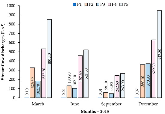
Figure 2.
Streamflow discharges (L s−1) at Córrego da Formiga, Quirinópolis/GO, Brazil.
It can be observed that in March and December 2015, there was a significant increase in the flow at the spring. This process occurs as a result of the rainfall regime, with regular and frequent events. Such rainfall regime is also associated to changes in water quality, as presented later. Moreover, rainfall–runoff relationships are strongly depended on land use at the sub-basins. Table 1 presents the land use at the watershed, obtained from the [34] product.

Table 1.
Land-use percentages, by control section (contribution area) to the monitoring stations in the Córrego da Formiga microbasin—Quirinópolis, Brazil.
3.2. Statistical Analysis of Water-Quality Parameters
In Table 2, the analysis of variance (ANOVA) for the water physical-chemical and biological parameters of the Córrego da Formiga is presented. The total coliform parameters, Escherichia coli, chloride, nitrate, magnesium, and fluorine were statistically different (p < 0.05), while the other parameters remained the same for the studied period: two during the dry season and two in the rainy season. The results come from the relationship with the differences between points 1 to 5, verified by the test of means (Tukey’s test).
Table 2.
Summary of analysis of variance (QM mean squares) and mean values of parameters indicative of water quality, monitored as a function of time, of Córrego da Formiga, Quirinópolis—GO, Brazil.
Table 2 represents the test of means for the water physical-chemical and biological parameters. The most significant parameters were fecal coliforms for the four analyzed periods as well as chloride and magnesium. Fluoride, nitrate and Escherichia coli also exhibited variations but only for the last field campaign; that is, the changes were more accentuated in relation to the time when the first and last sampling was carried out, which may be influenced by the increase in discharge, contributing to sediment transport and increasing suspended material concentrations due to overland flow.
According to the ANOVA procedure (Table 3) it can be observed that the parameters Coliforms T, Escher coli, fluorine, chloride, nitrate and magnesium, showed significant differences according to the sampling time at the Córrego da Formiga, with mean values of 2380 (June) to 13,280 (December); 319 (September) to 8500 (March); 0 (March) to 0.094 (December); 1.10 (June) to 6.50 (March); 0.0 (December) to 0.52 (March); and 0.776 (September) to 3.596 (June), respectively. Such result corroborates the study carried out by [45], who highlighted that the concentration of fecal coliforms and Escherichia coli depends on the sediments mixture at the bed of water courses, on sediment transport by overland flow, and on the hydrological regime.
Table 3.
Values of Pearson’s correlation (r) of water-quality parameters and land uses of Córrego da Formiga, GO, Brazil.
According to the results of the partial least squares discriminatory analysis (PLS-DA), there is a tendency towards positive values, whose spatial evaluation indicates interference through the adopted parameters. The PLS-DA analysis indicates different water-quality patterns for points 1, 2, 3, and 5, while point 4 overlaps with 3 and 5 (Figure 3A). The results allow us to verify that the adopted indicators successfully differentiate water-quality behaviors between the source (P1) and the outlet (P5) of the Córrego da Formiga. The total variance of the CP1 and CP2 components are 22.2 and 13.7%, respectively (Figure 3A).
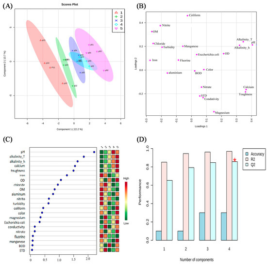
Figure 3.
Results of the multivariate analysis of components 1 and 2 of the PLS-DA (A), model weights and parameters (B), importance order and weights (scores) of the evaluated parameters (C), and accuracy and model performance (D) for the water physical-chemical and biological parameters of the Córrego da Formiga, Quirinópolis—GO, Brazil. Note: * significant at 5%.
Figure 3A,B point out a difference among the analyzed sampling points since points 1, 2, 3, and 5 are different, and point 4 is equal to points 3 and 5, as it presents an overlap, which means that the water quality is different at each sampling point. Figure 3C presents, in descending order, the parameters according to their importance for the separation of samples in terms of water quality (Figure 3A). The parameters pH, total alkalinity, alkalinity hCO, and calcium presented the higher relevance, while TDS, BOD, manganese, fluorine, and nitrate were those with lower weight.
It is also observed from Figure 3C that some parameters increased from P1 (source/spring) to P5 (mouth/outlet), such as total alkalinity, alkalinity hCO, and calcium, while other parameters decreased from upstream to downstream in the same sequence of points, such as OM and fluorine.
The parameters iron, chloride, OM, aluminum, nitrite, turbidity, and fluoride were more representative at points 1 and 2 at the head of the watershed. P1, located at the outlet of S1, is closer to an urban perimeter, and P2, which is influenced by S2, is between the transition of the urban sector and the rural zone. In addition to the urbanization adjacent to these points, there are highly representative uses of fish farming and pasture (Table 3). The parameters of magnesium, electrical conductivity (EC), and total dissolved solids (TDS) tend to present higher values at the initial points (1 and 2) of the watercourse.
According to the results obtained from the water-quality analysis, the Córrego da Formiga has class III water quality; that is, it is restricted for some uses, such as irrigation of crops that are consumed directly (e.g., fruits, vegetables), aquaculture and fishing activities, recreation from direct contact (e.g., bathing), and human consumption, with the latter requiring conventional or advanced water treatment. The results pointed to a stable profile regarding to environmental parameters for water-quality levels.
Turbidity showed a tendency to increase during the rainy periods (March and December) with mean values from 22 to 25 µT, while the mean values for the driest months (June and September) varied from 7 to 12 µT. Ref. [46] found turbidity level values ranging from 0–20 NTU for clean water during the dry season, while for in the turbid condition during the rainy season, the values were >50 NTU.
Surface runoff and erosive processes caused by rainfall events increase soil transport to springs and watercourses [22], a behavior also verified by [47]: during the rainy season, higher turbidity values were observed, decreasing water quality.
Parameters such as color, nitrate (NO3), nitrite (NO2), dissolved oxygen (DO), biochemical oxygen demand (BOD), total iron (Fe), manganese (Mn), and total coliforms (Escherichia coli) presented values above those established for Class III, according to Conama Resolution No. 357/2005 [30]. For these parameters, there is a relationship among color, Fe, and Mn, and the results pointed to an increase in the concentration of Fe and Mn in the water, which are responsible for the accentuated value of the color. It may represent the dissolution of rocks and minerals in the water or the impact of domestic, industrial, or agricultural effluents. Since such results refer to dry periods, the water dilution factor (self-purification) is reduced for lower flows and velocities.
With respect to OD and BOD, the data were divergent at the first collection station. Regarding the first parameter, the values were higher than the limit value established by [30], being linked to the presence of excess organic matter in a way that might impact the local aquatic life. For BOD, all points sampled were within the standards established by the Conama Resolution, and the results indicated an acceptable water quality.
Regarding the biological parameters, the total coliform values for all points sampled complied with [30], with no measurement above the standards established for class III water bodies. However, for the concentrations of Escherichia coli, the results pointed out indexes above those allowed, suggesting contamination by pathogenic microorganisms (fecal contamination). Therefore, for human consumption and domestic water supply, conventional treatment prior to its use and consumption is required. The other parameters are not directly related to the environmental assessment of Córrego da Formiga but represent interference factors that must be analyzed when dealing with potability standards and treatment systems for human consumption or irrigation, namely alkalinity, hardness, and chlorides.
Flow measurements (Figure 1) showed spatiotemporal variation from the springs to the outlet as a result of both overland flow (during rainfall events) and the anthropic impacts as well as water uses. When relating the streamflow to the water-quality parameters, it was verified that the seasonal variation defines the watershed hydrological water regime, reaching more critical discharges in the dry periods (September) and higher during the rainy months (March and December).
Extreme discharge values in the Córrego da Formiga reflect the water quality through physical-chemical parameters such as turbidity, electrical conductivity, dissolved oxygen, pH, and total dissolved solids, as they are directly related to the water dilution factor. In addition, such hydrological regimes trigger other environmental problems, such as contamination by carrying materials and silting, related to other indicators such as the BOD, iron and manganese, total coliforms, and Escherichia coli parameters.
4. Conclusions
Regarding the analyzed stations, the regions that presented better water-quality conditions were stations P2 and P5. At point P2, the region has pastures around the spring, with preserved and isolated permanent protection areas (PPA).
Regarding the water quality, better water quality was found during the dry season. The most expressive values were for March and September, which ends and starts the rainy cycle in the region, respectively.
The percentage of soil cover has an influence on water-quality parameters, with emphasis on the pH of the water, which has a high positive correlation with the sugarcane class (r = 0.956) and Cerrado (r = 0.868) and a high negative correlation with pasture (r = 0.911) and urban area (r = 0.841).
The water source flow is greatly influenced by the seasonality of the rains, with a significant decrease in the most critical period (September) even though the water quality has an improvement in the parameters evaluated, and although there is a decrease in the flow, there is also less carryover and influence of land uses adjacent to the spring.
The soil cover with native vegetation is just over 12%, while the predominance is of the classes of sugar cane (62.42%) and pasture (19.33%).
The PLS-DA analysis allowed separating the water analysis points between P1, P2, P3, and P5, while P4 was superimposed on others. It was also possible to verify that the parameters that weighed the most for this separation of water quality were pH, alkalinity_T, alkalinity_h, calcium, and hardness, all with a tendency to increase concentration from the source (P1) to the mouth (P5). As for water quality, it was also possible to verify that points P2 and P5 presented better water-quality conditions.
Author Contributions
Conceptualization, P.R.G., A.P.A.d.O.A., M.V.d.S., A.A.d.A.M. and J.H.d.S.T.; methodology, P.R.G., M.V.d.S., A.A.d.A.M. and A.M.M.G.; software, P.R.G., M.V.d.S., A.A.d.A.M. and A.M.M.G.; validation, P.R.G., A.P.A.d.O.A., M.V.d.S., A.A.d.A.M. and A.M.M.G.; formal analysis, P.R.G., M.V.d.S., A.A.d.A.M., A.M.M.G. and J.L.B.d.S.; investigation, P.R.G., M.V.d.S., A.A.d.A.M., A.M.M.G. and J.L.B.d.S.; resources, P.R.G., A.M.M.G., J.H.d.S.T., A.R.d.C. and P.C.S.; data curation, P.R.G., A.P.A.d.O.A., M.V.d.S. and A.A.d.A.M.; writing—original draft preparation, P.R.G., A.P.A.d.O.A., M.V.d.S., A.A.d.A.M., J.H.d.S.T., A.R.d.C., P.C.S., A.M.M.G. and J.L.B.d.S.; writing—review and editing, P.R.G., J.H.d.S.T., A.R.d.C., P.C.S., A.M.M.G., H.P., A.J.M.S., C.B. and M.B.F.; visualization, P.R.G., A.P.A.d.O.A., M.V.d.S., A.A.d.A.M., A.M.M.G., H.P., A.J.M.S., C.B., M.B.F. and J.L.B.d.S.; supervision, P.R.G., A.P.A.d.O.A., M.V.d.S., A.A.d.A.M., J.H.d.S.T., A.R.d.C., P.C.S., A.M.M.G. and J.L.B.d.S.; project administration, P.R.G., M.V.d.S., A.A.d.A.M. and A.M.M.G.; funding acquisition, P.R.G. and A.M.M.G. All authors have read and agreed to the published version of the manuscript.
Funding
This research received no external funding.
Institutional Review Board Statement
Not applicable.
Informed Consent Statement
Not applicable.
Data Availability Statement
Not applicable.
Acknowledgments
We offer thanks to the Programa de Pós-Graduação em Desenvolvimento Rural Sustentável (PGDRS) of the Universidade Estadual de Goiás–UEG And to the Programa de Pós-Graduação em Engenharia Agrícola (PGEA) and the Grupo de Pesquisa em Ambiência (GPESA) of the Universidade Federal Rural de Pernambuco (UFRPE) for supporting the development of this research. We are also grateful to the Coordenação de Aperfeiçoamento de Pessoal de Nível Superior (CAPES-Finance Code 001, and Conselho Nacional de Desenvolvimento Científico e Tecnológico (CNPq–Grant 308.890/2018-3) for the financing of scholarships.
Conflicts of Interest
The authors declare no conflict of interest.
References
- Pinto, C.C.; Calazans, G.M.; Oliveira, S.C. Assessment of Spatial Variations in the Surface Water Quality of the Velhas River Basin, Brazil, Using Multivariate Statistical Analysis and Nonparametric Statistics. Environ. Monit. Assess. 2019, 191, 164. [Google Scholar] [CrossRef]
- Veras, D.S.; Castro, E.R.; Lustosa, G.S.; Azevêdo, C.A.S.; Juen, L. Evaluating the Habitat Integrity Index as a Potential Surrogate for Monitoring the Water Quality of Streams in the Cerrado-Caatinga Ecotone in Northern Brazil. Environ. Monit. Assess. 2019, 191, 562. [Google Scholar] [CrossRef]
- Oliveira, M.E.G.; Silva, M.V.; Almeida, G.L.P.; Pandorfi, H.; Oliveira Lopes, P.M.; Manrique, D.R.C.; Santos, A.; Jardim, A.M.R.F.; Giongo, P.R.; Montenegro, A.A.A.; et al. Investigation of Pre and Post Environmental Impact of the Lockdown (COVID-19) on the Water Quality of the Capibaribe and Tejipió Rivers, Recife Metropolitan Region, Brazil. J. S. Am. Earth Sci. 2022, 118, 103965. [Google Scholar] [CrossRef]
- BRASIL LEI No 9.433, DE 8 DE JANEIRO DE 1997. Available online: http://www.planalto.gov.br/ccivil_03/leis/l9433.htm (accessed on 30 August 2022).
- Calazans, G.M.; Pinto, C.C.; Costa, E.P.; Perini, A.F.; Oliveira, S.C. Using Multivariate Techniques as a Strategy to Guide Optimization Projects for the Surface Water Quality Network Monitoring in the Velhas River Basin, Brazil. Environ. Monit. Assess. 2018, 190, 726. [Google Scholar] [CrossRef]
- Calazans, G.M.; Pinto, C.C.; Costa, E.P.; Perini, A.F.; Oliveira, S.C. The Use of Multivariate Statistical Methods for Optimization of the Surface Water Quality Network Monitoring in the Paraopeba River Basin, Brazil. Environ. Monit. Assess. 2018, 190, 491. [Google Scholar] [CrossRef]
- Soares, A.L.C.; Pinto, C.C.; Oliveira, S.C. Impacts of Anthropogenic Activities and Calculation of the Relative Risk of Violating Surface Water Quality Standards Established by Environmental Legislation: A Case Study from the Piracicaba and Paraopeba River Basins, Brazil. Environ. Sci. Pollut. Res. 2020, 27, 14085–14099. [Google Scholar] [CrossRef]
- Barcellos, D.S.; Schimaleski, A.P.C.; Souza, F.T. Downsizing Water Quality Monitoring Programs in River Basins in Brazil. Urban Water J. 2021, 18, 223–236. [Google Scholar] [CrossRef]
- Aleixo, B.; Pena, J.L.; Heller, L.; Rezende, S. Infrastructure Is a Necessary but Insufficient Condition to Eliminate Inequalities in Access to Water: Research of a Rural Community Intervention in Northeast Brazil. Sci. Total Environ. 2019, 652, 1445–1455. [Google Scholar] [CrossRef]
- Santos, S.M.; Farias, M.M.M.W.E.C. Potential for Rainwater Harvesting in a Dry Climate: Assessments in a Semiarid Region in Northeast Brazil. J. Clean. Prod. 2017, 164, 1007–1015. [Google Scholar] [CrossRef]
- Soares, J.A.B.; Camargo, G.; Giongo, P.R.; Gomes, L.F.; Costa, A.R.; Silva, P.C. Estudo Hidrológico Das Bacias Hidrograficas Em Santa Helena De Goiás. Braz. J. Dev. 2020, 6, 35629–35647. [Google Scholar] [CrossRef]
- Dantas, J.C.; Silva, R.M.; Santos, C.A.G. Drought Impacts, Social Organization, and Public Policies in Northeastern Brazil: A Case Study of the Upper Paraíba River Basin. Environ. Monit. Assess. 2020, 192, 317. [Google Scholar] [CrossRef]
- Donadio, N.M.M.; Galbiatti, J.A.; Paula, R.C. Qualidade Da Água de Nascentes Com Diferentes Usos Do Solo Na Bacia Hidrográfica Do Córrego Rico, São Paulo, Brasil. Eng. Agrícola 2005, 25, 115–125. [Google Scholar] [CrossRef]
- Viana, L.F.; Súarez, Y.R.; Cardoso, C.A.L.; Crispim, B.A.; Cavalcante, D.N.C.; Grisolia, A.B.; Lima-Junior, S.E. The Response of Neotropical Fish Species (Brazil) on the Water Pollution: Metal Bioaccumulation and Genotoxicity. Arch. Environ. Contam. Toxicol. 2018, 75, 476–485. [Google Scholar] [CrossRef]
- Duarte, G.S.C.; Lehun, A.L.; Leite, L.A.R.; Consolin-Filho, N.; Bellay, S.; Takemoto, R.M. Acanthocephalans Parasites of Two Characiformes Fishes as Bioindicators of Cadmium Contamination in Two Neotropical Rivers in Brazil. Sci. Total Environ. 2020, 738, 140339. [Google Scholar] [CrossRef]
- Ferreira, M.S.; Fontes, M.P.F.; Pacheco, A.A.; Lima, H.N.; Santos, J.Z.L. Risk Assessment of Trace Elements Pollution of Manaus Urban Rivers. Sci. Total Environ. 2020, 709, 134471. [Google Scholar] [CrossRef]
- Böger, B.; Surek, M.; Vilhena, R.O.; Fachi, M.M.; Junkert, A.M.; Santos, J.M.M.F.; Domingos, E.L.; Cobre, A.F.; Momade, D.R.; Pontarolo, R. Occurrence of Antibiotics and Antibiotic Resistant Bacteria in Subtropical Urban Rivers in Brazil. J. Hazard. Mater. 2021, 402, 123448. [Google Scholar] [CrossRef]
- Branche, E. The Multipurpose Water Uses of Hydropower Reservoir: The SHARE Concept. Comptes Rendus Phys. 2017, 18, 469–478. [Google Scholar] [CrossRef]
- Hogeboom, R.J.; Knook, L.; Hoekstra, A.Y. The Blue Water Footprint of the World’s Artificial Reservoirs for Hydroelectricity, Irrigation, Residential and Industrial Water Supply, Flood Protection, Fishing and Recreation. Adv. Water Resour. 2018, 113, 285–294. [Google Scholar] [CrossRef]
- Lathuillière, M.J.; Coe, M.T.; Castanho, A.; Graesser, J.; Johnson, M.S. Evaluating Water Use for Agricultural Intensification in Southern Amazonia Using the Water Footprint Sustainability Assessment. Water 2018, 10, 349. [Google Scholar] [CrossRef]
- Cetin, M. Agricultural Water Use. In Water Resources of Turkey; Springer: Cham, Switzerland, 2020; Volume 2, pp. 257–302. [Google Scholar]
- Peixoto, R.M.; Giongo, P.R.; Backes, C.; Silva, P.C. Soil and Water Conservation Techniques in Agriculture: Characterization of the Contribution Area of Dams. Res. Soc. Dev. 2022, 11, e15411526694. [Google Scholar] [CrossRef]
- Rasul, G.; Neupane, N.; Hussain, A.; Pasakhala, B. Beyond Hydropower: Towards an Integrated Solution for Water, Energy and Food Security in South Asia. Int. J. Water Resour. Dev. 2019, 37, 466–490. [Google Scholar] [CrossRef]
- Tundisi, J.G.; Tundisi, T.M. Recursos Hídricos No Século XXI, 1st ed.; Oficina de Textos: Viçosa, Brazil, 2011; ISBN 9788579750120. [Google Scholar]
- Resende, F.M.; Denman, L.A.C.; Selva, G.V.; Campanhão, L.M.B.; Nobre, R.L.G.; Jimenez, Y.G.; Lima, E.M.; Niemeyer, J. A Conceptual Model to Assess the Impact of Anthropogenic Drivers on Water-Related Ecosystem Services in the Brazilian Cerrado. Biota Neotrop. 2020, 20, e20190899. [Google Scholar] [CrossRef]
- Telles, T.S.; Reydon, B.P.; Maia, A.G. Effects of No-Tillage on Agricultural Land Values in Brazil. Land Use Policy 2018, 76, 124–129. [Google Scholar] [CrossRef]
- Buainain, A.M.; Garcia, J.R. Agriculture and the Environment: A Conflictive and Ambiguous Antinomy in Recent Brazilian Development. In Agricultural Development in Brazil: The Rise of a Global Agro-food Power; Taylor and Francis: Abingdon, UK, 2019; pp. 139–151. ISBN 9781351029735. [Google Scholar]
- Lopes, V.C.; Parente, L.L.; Baumann, L.R.F.; Miziara, F.; Ferreira, L.G. Land-Use Dynamics in a Brazilian Agricultural Frontier Region, 1985–2017. Land Use Policy 2020, 97, 104740. [Google Scholar] [CrossRef]
- Brauman, K.A.; Daily, G.C.; Duarte, T.K.; Mooney, H.A. The Nature and Value of Ecosystem Services: An Overview Highlighting Hydrologic Services. Annu. Rev. Environ. Resour. 2007, 32, 67–98. [Google Scholar] [CrossRef]
- CONAMA RESOLUÇÃO CONAMA N° 357, DE 17 DE MARÇO DE 2005. Available online: https://www.icmbio.gov.br/cepsul/images/stories/legislacao/Resolucao/2005/res_conama_357_2005_classificacao_corpos_agua_rtfcda_altrd_res_393_2007_397_2008_410_2009_430_2011.pdf (accessed on 29 August 2022).
- Alvares, C.A.; Stape, J.L.; Sentelhas, P.C.; Gonçalves, J.L.M.; Sparovek, G. Köppen’s Climate Classification Map for Brazil. Meteorol. Zeitschrif 2013, 22, 711–728. [Google Scholar] [CrossRef]
- Beck, H.E.; Zimmermann, N.E.; McVicar, T.R.; Vergopolan, N.; Berg, A.; Wood, E.F. Present and Future Köppen-Geiger Climate Classification Maps at 1-Km Resolution. Sci. Data 2018, 5, 180214. [Google Scholar] [CrossRef]
- INMET BDMEP—Banco de Dados Meteorológicos Para Ensino e Pesquisa. Available online: https://www.gov.br/agricultura/pt-br/assuntos/inmet?r=bdmep/bdmep (accessed on 30 August 2022).
- MapBiomas Brasil PLATAFORMA DE MAPA E DADOS. Available online: https://plataforma.brasil.mapbiomas.org/?activeBaseMap=9&layersOpacity=70&activeModule=coverage&activeModuleContent=coverage%3Acoverage_main&activeYear=2021&mapPosition=-15.072124%2C-51.547852%2C4&timelineLimitsRange=1985%2C2021&baseParams[territoryType]= (accessed on 30 August 2022).
- Pinheiro, A.; Schoen, C.; Schultz, J.; HEINZ, K.G.H.; Pinheiro, I.G.; Deschamps, F.C. Relação Entre o Uso Do Solo e a Qualidade Da Água Em Bacia Hidrográfica Rural No Bioma Mata Atlântica. Rev. Bras. Recur. Hídricos 2014, 19, 127–139. [Google Scholar] [CrossRef]
- SIEG Arquivo Shapefile Bacia Hidrográfica. Available online: http://www.sieg.go.gov.br/siegdownloads/ (accessed on 30 August 2022).
- APHA; WWA; WPCF. Standard Methods for the Examination of Water and Wastewater, 19th ed.; American Public Health Association: Washington, DC, USA, 1995. [Google Scholar]
- Carvalho, T.M. Técnicas de Medição de Vazão Por Meios Convencionais e Não Convencionais. Rev. Bras. Geogr. Física 2008, 1, 73–85. [Google Scholar] [CrossRef][Green Version]
- Hatfield, K.; Annable, M.; Cho, J.; Rao, P.S.C.; Klammler, H. A Direct Passive Method for Measuring Water and Contaminant Fluxes in Porous Media. J. Contam. Hydrol. 2004, 75, 155–181. [Google Scholar] [CrossRef]
- EPA. Volunteer Stream Monitoring: A Methods Manual; EPA: Washignton, DC, USA, 1997; pp. 134–138. [Google Scholar]
- Paredes-Trejo, F.J.; Barbosa, H.A.; Kumar, T.V.L. Validating CHIRPS-Based Satellite Precipitation Estimates in Northeast Brazil. J. Arid Environ. 2017, 139, 26–40. [Google Scholar] [CrossRef]
- Pang, Z.; Zhou, G.; Ewald, J.; Chang, L.; Hacariz, O.; Basu, N.; Xia, J. Using MetaboAnalyst 5.0 for LC–HRMS Spectra Processing, Multi-Omics Integration and Covariate Adjustment of Global Metabolomics Data. Nat. Protoc. 2011, 6, 743–760. [Google Scholar] [CrossRef] [PubMed]
- Taveira, J.H.S.; Borém, F.M.; Figueiredo, L.P.; Reis, N.; Franca, A.S.; Harding, S.A.; Tsai, C.J. Potential Markers of Coffee Genotypes Grown in Different Brazilian Regions: A Metabolomics Approach. Food Res. Int. 2014, 61, 75–82. [Google Scholar] [CrossRef]
- Bermudez-Edo, M.; Barnaghi, P.; Moessner, K. Analysing Real World Data Streams with Spatio-Temporal Correlations: Entropy vs. Pearson Correlation. Autom. Constr. 2018, 88, 87–100. [Google Scholar] [CrossRef]
- Gonçalves, C.S.; Rheinheimer, D.S.; Pellegrini, J.B.R.; Kist, S.L. Qualidade Da Água Numa Microbacia Hidrográfica de Cabeceira Situada Em Região Produtora de Fumo. Rev. Bras. Eng. Agrícola Ambient. 2005, 9, 391–399. [Google Scholar] [CrossRef][Green Version]
- Martins, V.S.; Kaleita, A.; Barbosa, C.C.F.; Fassoni-Andrade, A.C.; Lobo, F.L.; Novo, E.M.L.M. Remote Sensing of Large Reservoir in the Drought Years: Implications on Surface Water Change and Turbidity Variability of Sobradinho Reservoir (Northeast Brazil). Remote Sens. Appl. Soc. Environ. 2019, 13, 275–288. [Google Scholar] [CrossRef]
- Michelan, D.C.G.S.; Batista, I.F.; Batista, D.F.; Santos, D.G.; Mendonça, L.C.; Lima, D.M.F. Desempenho Das Etapas de Tratamento de Água, Da Estação de Tratamento de Água Poxim. Sci. Cum. Ind. 2019, 7, 7–14. [Google Scholar] [CrossRef]
Publisher’s Note: MDPI stays neutral with regard to jurisdictional claims in published maps and institutional affiliations. |
© 2022 by the authors. Licensee MDPI, Basel, Switzerland. This article is an open access article distributed under the terms and conditions of the Creative Commons Attribution (CC BY) license (https://creativecommons.org/licenses/by/4.0/).