
Black Soils in the Eastern Mediterranean: Genesis and Properties


Abstract
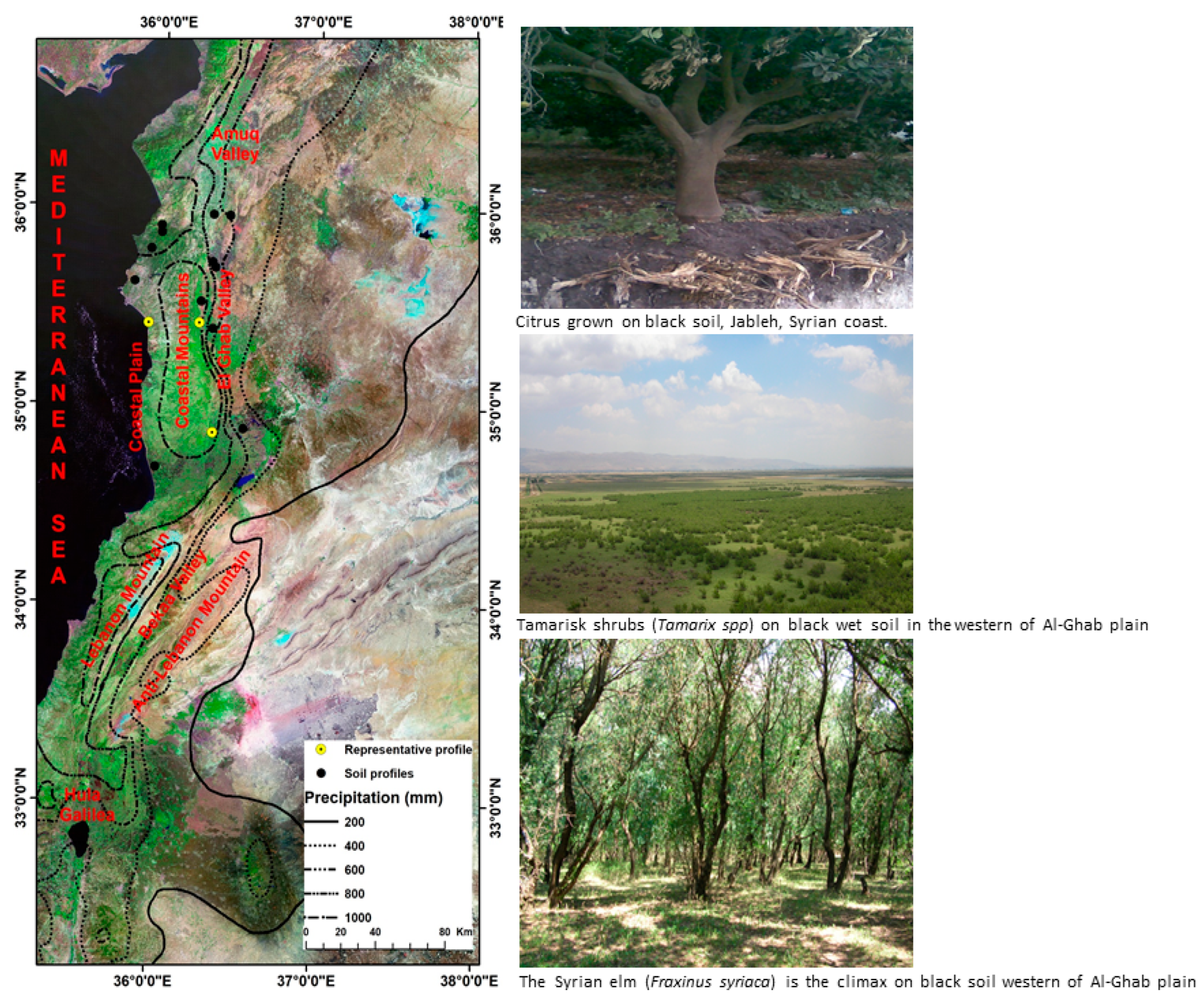
:1. Introduction
2. Materials and Methods
- i.
- Upper humid stage, cold.
- ii.
- Lower sub-humid stage, fresh.
- iii.
- Lower sub-humid stage, temperate.
- iv.
- Upper semi-arid.
3. Results
3.1. Soil Morphology
3.2. Soil Physical Properties
3.3. Soil Chemical Properties
4. Discussion
- Calcareous black soils (rendzina) on littoral plains and hilly areas.
- Hydromorphic black soils in depressions.
- Black soil on basalt.
- Calcareous black soils
- Hydromorphic black soils
- Black soil on basalt
5. Conclusions
Author Contributions
Funding
Data Availability Statement
Acknowledgments
Conflicts of Interest
References
- FAO. DEFINITION|What Is a Black Soil? 2019. Available online: https://www.fao.org/global-soil-partnership/intergovernmental-technical-panel-soils/gsoc17-implementation/internationalnetworkblacksoils/more-on-black-soils/definition-what-is-a-black-soil/ru/ (accessed on 8 June 2023).
- FAO. Global Status of Black Soils; FAO: Rome, Italy, 2022. [Google Scholar] [CrossRef]
- Han, X.; Li, N. Research Progress of Black Soil in Northeast China. Sci. Geogr. Sin. 2018, 38, 1032–1041. [Google Scholar] [CrossRef]
- Song, C.; Lu, W.; Du, H. Degradation of Black Soil Quality and Strategies of Prevention Control in Northeast Plain, China. In Proceedings of the 7th International Conference on Water Resource and Environment (WRE 2021), Online, 1–4 November 2022; Available online: https://www.scitepress.org/Papers/2021/110203/110203.pdf (accessed on 1 November 2022).
- Andreeva, D.; Leiber, K.; Glaser, B.; Hambach, U.; Erbajeva, M.; Chimitdorgieva, G.; Tashak, V.; Zech, W. Genesis and properties of black soils in Buryatia, southeastern Siberia, Russia. Quat. Int. 2011, 243, 313–326. [Google Scholar] [CrossRef]
- IUSS Working Group WRB. World Reference Base for Soil Resources. International Soil Classification System for Naming Soils and Creating Legends for Soil Maps, 4th ed.; International Union of Soil Sciences (IUSS): Vienna, Austria, 2022. [Google Scholar]
- Soil Survey Staff. Keys to Soil Taxonomy, 13th ed.; U.S. Department of Agriculture, Natural Resources Conservation Service: Washington, DC, USA, 2022.
- Sorokin, A.; Owens, P.; Láng, V.; Jiang, Z.-D.; Michéli, E.; Krasilnikov, P. “Black soils” in the Russian Soil Classification system, the US Soil Taxonomy and the WRB: Quantitative correlation and implications for pedodiversity assessment. CATENA 2021, 196, 104824. [Google Scholar] [CrossRef]
- Liu, X.; Burras, C.L.; Kravchenko, Y.S.; Duran, A.; Huffman, T.; Morras, H.; Studdert, G.; Zhang, X.; Cruse, R.M.; Yuan, X. Overview of Mollisols in the world: Distribution, land use and management. Can. J. Soil Sci. 2012, 92, 383–402. [Google Scholar] [CrossRef]
- Smreczak, B.; Jadczyszyn, J.; Kabała, C. Przydatnoœć rolnicza rędzin w Polsce. Soil Sci. Annu. 2018, 69, 142–151. [Google Scholar] [CrossRef]
- FAO; ITPS. Status of the world’s soil resources (SWSR)–main report. In Food and Agriculture Organization of the United Nations and Intergovernmental Technical Panel on Soils; FAO: Rome, Italy, 2015. [Google Scholar]
- Lal, R. Soil carbon management and climate change. Carbon Manag. 2013, 4, 439–462. [Google Scholar] [CrossRef]
- Hag Husein, H.; Lucke, B.; Bäumler, R.; Sahwan, W. Contribution to Soil Fertility Assessment for Arid and Semi-Arid Lands. Soil Syst. 2021, 5, 42. [Google Scholar] [CrossRef]
- Achiba, W.B.; Gabteni, N.; Lakhdar, A.; Laing, G.D.; Verloo, M.; Jedidi, N.; Gallali, T. Effects of 5-year application of municipal solid waste compost on the distribution and mobility of heavy metals in a Tunisian calcareous soil. Agric. Ecosyst. Environ. 2009, 130, 156–163. [Google Scholar] [CrossRef]
- Parras-Alcántara, L.; Lozano-García, B.; Keesstra, S.; Cerdà, A.; Brevik, E.C. Long-term effects of soil management on ecosystem services and soil loss estimation in olive grove top soils. Sci. Total Environ. 2016, 571, 498–506. [Google Scholar] [CrossRef]
- Muñoz-Rojas, M.; Jordán, A.; Zavala, L.M.; De la Rosa, D.; Abd-Elmabod, S.K.; Anaya-Romero, M. Organic carbon stocks in Mediterranean soil types under different land uses (Southern Spain). Solid Earth 2012, 3, 375–386. [Google Scholar] [CrossRef]
- Hag Husein, H.; Mousa, M.; Sahwan, W.; Bäumler, R.; Lucke, B. Spatial Distribution of Soil Organic Matter and Soil Organic Carbon Stocks in Semi-Arid Area of Northeastern Syria. Nat. Resour. 2019, 10, 415–432. [Google Scholar] [CrossRef]
- Ahmet, C. Soil organic carbon losses by water erosion in a Mediterranean watershed. Soil Res. 2016, 55, 363–375. [Google Scholar] [CrossRef]
- Tarzi, J.G.; Paeth, R.C. Genesis of a Mediterranean red and a white rendzina soil from Lebanon. Soil Sci. 1975, 120, 272–277. [Google Scholar] [CrossRef]
- Reifenberg, A. The Soils of Palestine, 2nd ed.; Thomas Murbery and Co.: London, UK, 1947. [Google Scholar]
- Durand, R.; Dutil, P. Experimental alteration of calcareous and dolomitic rocks-Importance of rock structure and its mineralogical nature. Acad. Sci. Paris CR Ser. D 1971, 272, 2423. [Google Scholar]
- Geze, B. Carte de Reconnaissance de Sols du Liban; MinistCre de 1′Agriculture. Direction de 1′Enseignement et de la Vulgarisation: Beirut, Lebanon, 1956.
- Miklaszewski, S. Mémoire Relatif à la Pologne, Mémoires sur la Nomenclature et la Classification des Sols; Imprimerie de l’État Finlande: Helsinki, Finland, 1924; pp. 245–255. [Google Scholar]
- Sayegh, A.H.; Salib, A.J. Some physical and chemical properties of soils in the Beqa’a plain, Lebanon. J. Soil Sci. 1969, 20, 167–175. [Google Scholar] [CrossRef]
- Çepel, N. Sedir Yetisme Muhiti Tanitinimin Pratik Esaslari ve Orman Yetisme Muhiti Haritaciligi; Kurtulus Matbaasi: Istanbul, Turkey, 1966. [Google Scholar]
- Darwish, T.M.; Zurayk, R.A. Distribution and nature of Red Mediterranean soils in Lebanon along an altitudinal sequence. CATENA 1997, 28, 191–202. [Google Scholar] [CrossRef]
- Muir, A. Notes on the Soil of Syria. J. Soil Sci. 1951, 2, 163–187. [Google Scholar] [CrossRef]
- Nahal, I. Contribution à l’étude de la végétation dans le Baer-Bassit et le Djebel Alaouite de Syrie. Webbia 1962, 16, 477–641. [Google Scholar] [CrossRef]
- Nahal, I. The Mediterranean climate from a biological viewpoint. In Mediterranean-Type Shrublands. Ecosystem of the World; Di Castri, F., Goodall, W., Specht, R.L., Eds.; Elsevier Scientific Publishing Company: Amsterdam, NL, USA, 1981; Chapter 3; Volume 11, pp. 63–86. [Google Scholar]
- Van Lier, W.J. Classification and Rational Utilization of Soils; Report to the Government of Syria; FAO: Rome, Italy, 1965; p. 141. [Google Scholar]
- Zain al Abdeen, A.N. Principles of Soil Science; University of Aleppo: Aleppo, Syria, 1978; pp. 250–270. [Google Scholar]
- Chalabi, M.N. Analyse Phytosociologique, Phytoécologique, Dendrométrique et Dendroclimatologique des Forêts de Quercus Cerris Subsp. Pseudocerris et Contribution à l’ Étude Taxinomique du Genre Quercus L. en Syrie. Ph.D. Thesis, Université d’ Aix, Marseille, France, 1980; pp. 137–141, III 342p. + annexes de 171 p. Ecologia Mediterranea T.VIII, (Fascicule 1/2). Marseille. [Google Scholar]
- Ilaiwi, M. Contribution to the Knowledge of the Soils of Syria. Ph.D. Thesis, Ghent University, Ghent, Belgium, 1983; p. 259. [Google Scholar]
- Moormann, F. The Soils of East Jordan: Report to the Government of Jordan (Expanded Technical Assistance Program No. 1132); FAO: Rome, Italy, 1959. [Google Scholar]
- Ministry of Agriculture, Jordan (MoA). The Soils of Jordan: Level 1 (Reconnaissance Survey); Report of the National Soil Map and Land Use Project; Ministry of Agriculture: Amman, Jordan, 1993; Volume 1.
- Ministry of Agriculture, Jordan (MoA). The Soils of Jordan: Level 2 (Semi Detailed Studies); Report of the National Soil Map and Land Use Project; Ministry of Agriculture: Amman, Jordan, 1995; Volume 3.
- Khresat, S.E.A. Nature and properties of mollisols in a semiarid region in northern Jordan. Commun. Soil Sci. Plant Anal. 1999, 30, 2429–2436. [Google Scholar] [CrossRef]
- Lucke, B.; Schmidt, M.; al-Saad, Z.; Bens, O.; Hüttl, R.F. The Abandonment of the Decapolis Region in Northern Jordan—Forced by Environmental Change? Quat. Int. 2005, 135, 65–81. [Google Scholar] [CrossRef]
- Lucke, B. Demise of the Decapolis. Past and Present Desertification in the Context of Soil Development, Land Use, and Climate. Ph.D. Thesis, BTU Cottbus, Cottbus, Germany, Omni Scriptum, Saarbrücken, Germany, 2008. [Google Scholar]
- Lucke, B.; Kemnitz, H.; Bäumler, R. Evidence for isovolumetric replacement in Terrae Rossae of Jordan. Bol. Soc. Geol. Mex. 2012, 64, 21–35. [Google Scholar] [CrossRef]
- Soil Atlas of El-Zawia and El-Wstani Mountains, Hussam Hag Husein, General Commission for Scientific Agricultural Research; Damascus: Douma, Syria, 2012; p. 255. ISBN 978-9933-9238-5-3. Available online: https://www.researchgate.net/publication/366185616_SOIL_ATLAS_OF_El-ZAWIA_El-WASTANI_MOUNTAINS (accessed on 18 December 2023).
- Emberger, L. Une Classification Biogeographique des Climates; Recueil, travaux de laboratoire géolo-zoologique, Faculté des sciences; Scientific Research: Montpellier, France, 1955; Volume 7, pp. 3–43. [Google Scholar]
- Soil Survey Division Staff. Soil Survey Manual; U.S. Department of Agriculture Handbook 18; U.S. Government Publishing Office: Washington, DC, USA, 1993; p. 510.
- U.S.D.A-NRCS. Field Book for Describing and Sampling Soils. v 1.1; USDA-NRCS: Lincoln, NE, USA, 1998; p. 182.
- Walkley, A.; Black, A. An examination of the Degtjareff method for determining soil organic matter and a proposed modification of the chromic acid titration method. Soil Sci. 1934, 37, 29–38. [Google Scholar] [CrossRef]
- Nelson, D.W.; Sammers, L.E. Total carbon and organic matter. In Methods of Soil Analysis, Part 2; Page, A.L., Miller, R.H., Keeney, D.R., Eds.; ASA-SSSA: Madison, WI, USA, 1982; pp. 539–579. [Google Scholar]
- Soil Survey Staff. Soil Taxonomy: A Basic System of Soil Classification for Making an Interpreting Soil Survey; U.S. Department of Agriculture Handbook 436; U.S. Government Publishing Office: Washington, DC, USA, 1975; p. 503.
- Soil Conservation Service. Soil Survey Laboratory Methods; Soil Survey Investigations Report No 42; U.S. Department of Agriculture: Washington, DC, USA, 1992; p. 400.
- Mehlich, A. Use of Triethanolamine Acetate-Barium Hydroxide Buffer for the Determination of Some Base Exchange Properties and Lime Requirement of Soil 1. Soil Sci. Soc. Am. J. 1939, 3, 162–166. [Google Scholar] [CrossRef]
- Soil Survey Staff. Kellogg Soil Survey Laboratory Methods Manual; Soil Survey Investigations Report No. 42, Version 5.0; Burt, R., Soil Survey Staff, Eds.; U.S. Department of Agriculture, Natural Resources Conservation Service: Washington, DC, USA, 2014.
- Soil Survey Staff. Keys to Soil Taxonomy, 12th ed.; U.S. Department of Agriculture, Natural Resources Conservation Service: Washington, DC, USA, 2014.
- Turski, R.; Domżał, H.; Borowiec, J.; Flis-Bujak, M.; Misztal, M. Gleboznawstwo. Ćwiczenia dla Studentów Wydziałów Rolniczych; Polish Scientific Publishers PWN: Warsaw, Poland, 1986; pp. 1–278. [Google Scholar]
- Kjeldahl, J. Neue Methodezur Bestimmung des Sticksoffs in organischen Körpern. Z. Anal. Chem. 1883, 22, 36–382. [Google Scholar] [CrossRef]
- McRae, S.G. Practical Pedology Studying Soils in the Field; Ellis Horwood Limited: Chichester, UK, 1988; p. 253. ISBN 0-85312-918-5. [Google Scholar]
- Olsen, S.R.; Cole, F.; Watanabe, S.; Dean, L.A. Estimation of Available Phosphorus in Soil by Extraction with Sodium Bicarbonate; U.S. Department of Agriculture Circular 939; U.S. Department of Agriculture: Washington, DC, USA, 1954; p. 18.
- Jackson, M.L. Instrument in soils and waters. J. Agric. Food Chem. 1956, 4, 602–605. [Google Scholar] [CrossRef]
- Habib, H. Genesis, surface charge and classification of soil developed on lcanic ashand basalt in an arid climate (Syria). Ph.D. Thesis, Ghent University, Ghent, Belgium, 1986; p. 192. [Google Scholar]
- Habib, H. Pedological study of soil topo-sequence on Daher Al-jabal, Swieda Governorate. Univ. Damascus Syr. 2006, 22, 181–209. (In Arabic) [Google Scholar]
- Arnold, R.W. Multiple Working Hypothesis in Soil Genesis 1. Soil Sci. Soc. Am. J. 1965, 29, 717–724. [Google Scholar] [CrossRef]
- Kabała, C. Rendzina (rędzina)-Soil of the Year 2018 in Poland. Introduction to origin, cłassification and land use of rendzinas. Soil Sci. Annu. 2018, 69, 63–74. [Google Scholar] [CrossRef]
- Miechówka, A.; Drewnik, M. Rendzina soils in the Tatra Mountains, central Europe: A review. Soil Sci. Annu. 2018, 69, 88–100. [Google Scholar] [CrossRef]
- Lucke, B.; Hag Husein, H.; Sahwan, W.; Bäumler, R. A preliminary survey of soils and sediments in the Dead Cities region, northwestern Syria. In The “Dead Cities” of Northern Syria and Their Demise; Riis, T., Ed.; Verlag Ludwig: Kiel, Germany, 2015; pp. 33–59. [Google Scholar]
- Erdağ, A.; Kirmaci, M.; Tizini, I.; Kashlan, A.; Addine, B.C. Contributions to the moss flora of the Al-Ghab plain (north-west Syria). Turk. J. Bot. 2013, 37, 369–374. [Google Scholar]
- Hag Husein, H.; Kalkha, M.; Al Jrdi, A.; Bäumler, R. Urban Soil Pollution with Heavy Metals in Hama Floodplain, Syria. Nat. Resour. 2019, 10, 187–201. [Google Scholar] [CrossRef]
- Technoexport. The Geological Map of Syria. Scale 1:1,000,000: Explanatory Notes; Ministry of Industry: Damascus, Syria, 1966; 111p.
- Hag Husein, H.; Nammora, T.; Zaghtiti, I.; Al-Khateeb, A.; Zenyah, E. Soil Catena Properties of Daher Al-Jabal IN south Syria. Int. J. Environ. 2017, 6, 87–107. Available online: http://www.nepjol.info/index.php/IJE/article/view/16870/13714 (accessed on 18 December 2023). [CrossRef]


| Profile Code | Coordinates and Elevation | Rainfall mm | Bio-Climate Stage | Physiographic and Topographic Position | Drainage Class | Vegetation | Parent Material | Classification | |
|---|---|---|---|---|---|---|---|---|---|
| ST ** | WRB *** | ||||||||
| Jableh | 35°25′10.67″ N 35°55′23.37″ E 28 m.a.s.l * | 863 | sub humid, hot | littoral undulating plain, very gentle slope | moderately well drained, very slow surface runoff | pinus brutia | Calcareous sandstone and conglomerates | Typic Rendolls | Rendzic Mollic Leptosols |
| Al Qanjra | 35°37′43.7″ N 35°49′40.13″ E 10 m.a.s.l | 797 | sub humid, hot | littoral flat plain, very gentle slope | moderately well drained, very slow surface runoff | cultivated olive trees | Pliocene marls and limestones | Typic Calcixerolls | Calcic Chernozems |
| Kassab Zanzaf | 35°47′44.77″ N 35°55′46.52″ E 240 m.a.s.l | 1248 | humid temperate | littoral high hilly, footslope | well drained, rapid surface runoff, moderately slow permeability | pome trees | Undifferentiated complex of igneous rock predominated by serpentine of Mesozoic era | Typic Rendolls | Rendzic Leptosols |
| Kassab Nibh Al mur | 35°52′41.93″ N 35°59′35.60″ E 380 m.a.s.l | 1248 | humid temperate | littoral high hilly, middle slope of mountainous area | well drained, rapid surface runoff, moderately slow permeability | pome and stone fruit trees | Undifferentiated complex of igneous rock predominated by serpentine of Mesozoic era | Entic Ultic Haploxerolls | Rendzic Leptosols |
| Kassab | 35°54′47.54″ N 35°59′24.10″ E 800 m.a.s.l | 1248 | humid temperate | littoral high hilly, middle slope of high hills | well drained, rapid surface runoff, moderately rapid permeability | pinus brutia | Undifferentiated complex of igneous rock predominated by serpentine of Mesozoic era | Entic Ultic Haploxerolls | Rendzic Sekeletic Leptosols |
| Der Athman | 35°58′22.8″ N 36°19′16.2″ E 325 m.a.s.l | 679 | sub humid temperate | inland mountainous area, back slope of undulating hills | well drained | cultivated olive and stone fruit trees | Limestone | Calcic Pachic Haploxerolls | Leptic Calcic Kastanozem |
| Drkosh-Al daher | 35°58′04.8″ N 36°25′37.9″ E 530 m.a.s.l | 679 | sub humid temperate | inland mountainous area, back slope of undulating hills | Well drained | shrubs and cultivated olive trees | Dolostones and hard limestone | Entic Ultic Haploxerolls | Rendzic Humic Leptosols |
| Akkar-Zahed | 34°41′38.66″ N 35°59′12.36″ E 1.0 m.a.s.l | 1150 | sub humid hot | littoral plain, flat plain | poorly drained, very slow surface runoff, slow permeability | irrigated vegetables and greenhouses | Quaternary and recent colluvium and alluvium derived mainly from Neogene basalt | Vertic Haploxerolls | Vertic Chernozems |
| Barshin | 34°52′20.60″ N 36°20′37.41″ E 930 m.a.s.l | 994 | humid temperate | littoral high hilly, back slope of high hills | moderately well drained, rapid runoff, slow permeability | pome trees | Pliocene basalt | Typic Haploxerolls | Cambic Skeletic Phaeozems |
| Houla | 34°53′42.88″ N 36°32′11.59″ E 375 m.a.s.l | 480 | semi-arid temperate | level flood plain | Somewhat poorly drained | field crops and irrigated vegetables | Alluvial deposits of quaternary to more recent era, derived mainly from Neogene basalt | Aquic Haploxerolls | Vertic Kastanozems |
| Al-Ghab-Joureen | 35°31′58.92″ N 36°15′7.67″ E 180 m.a.s.l | 871 | sub-humid temperate | rift valley level to depression valley fills | moderately well drained, very slow surface runoff, slow permeability | elms trees | Quaternary or more recent marl diatomaceous, lacustrine deposition | Aquic Haploxerolls | Leptic Kastanozems |
| Al-Gab Enab | 35°25′25.40″ N 36°14′41.89″ E 182 m.a.s.l | 871 | sub-humid temperate | rift valley level to depression valley fills | moderately well drained, very slow surface runoff, slow permeability | elms trees | Quaternary or more recent marl diatomaceous, lacustrine deposition | Aquic Haploxerolls | Vermic Chernozems |
| Al-Ghab-Al Kareem | 35°23′48.30″ N 36°19′49.73″ E 178 m.a.s.l | 695 | sub-humid temperate | rift valley level to depressional valley fills | moderately well drained, very slow surface run-off, slow permeability | irrigated agriculture | Quaternary or more recent marl diatomaceous lacustrine deposits | Patchic Haploxerolls | Haplic Chernozems |
| Al-Ghab-Qarqor | 35°43′58.76″ N 36°19′13.47″ E 170 m.a.s.l | 679 | sub-humid temperate | rift valley level to depressional valley fills | moderately well drained, very slow surface run-off, slow permeability | irrigated agriculture | Quaternary or more recent marl diatomaceous lacustrine deposits | Patchic Haploxerolls | Haplic Chernozems |
| Al-Ghab-Mshik | 35°42′20″ N 36°20′26.7″ E 175 m.a.s.l | 693 | sub-humid temperate | rift valley level to depressional valley fills | moderately well drained, very slow surface run-off, slow permeability | irrigated agriculture | Quaternary or more recent marl diatomaceous lacustrine deposits | Patchic Haploxerolls | Haplic Chernozems |
| Hor-izon | Depth (cm) | Color | Structure | Consistence | Pores | Roots | Boundary | Special Features | |
|---|---|---|---|---|---|---|---|---|---|
| Dry | Moist | ||||||||
| Jableh, Typic Rendolls/Rendzic Mollic Leptosols | |||||||||
| Oi | 5–0 | dark gray brown 7.5YR3/3 | very dark gray 7.5YR3/1 | midrate medium fine granular | slightly plastic | - | abundant very fine to medium | abrupt smooth | slightly decomposed plant material frequent rounded stone constituting approximately 10% |
| A | 0–35 | - | dark reddish brown 5YR3/3 | weak fine granular | sticky and plastic | few very fine and fine discontinuous irregular, simple, open | few fine and very fine | clear wavy | roots mostly inside peds |
| A2 | 35–50 | dark reddish brown 2.5YR3/4 | - | fine granular | sticky and plastic | few fine vertical in ped, simple, closed | few fine | very abrupt smooth | few small soft carbonate stones |
| C | 50+ | - | pale yellow 10YR8/3 and pink 7.5YR8/3 | - | - | - | - | - | conglomerates calcareous sandstone |
| Al-Ghab, Aquic Haploxerolls/Vermic Chernozems | |||||||||
| A | 0–26 | dark brown 10YR3/3 | black 10YR2/1 | moderate medium granular | soft (dry) slightly firm (moist) sticky and plastic | many fine horizontal in ped, simple, open | plenty fine | abrupt smooth | roots between peds |
| A2 | 26–55 | - | very dark grayish brown 10YR3/2 | fine granular | firm (moist) sticky and plastic | few fine vertical in ped, simple, closed | plenty fine | gradual wavy boundary | roots between peds |
| AC | 55+ | - | dark gray 10YR4/1 | massive | firm (moist) sticky and plastic | few fine vertical in ped, simple, closed | few fine inside peds | - | few small soft carbonate accumulations on ped faces |
| Barshin, Typic Haploxerolls/Cambic Skeletic Phaeozems | |||||||||
| Ap | 0–18 | dark brown 7.5YR3/3 | very dark grayish brown 10YR3/2 | moderate medium subangular blocky breaking to moderate firm granular | very hard (dry) firm (moist) sticky and plastic | fine and medium dis-continuous, vertical, open | few fine | clear smooth | de-rocking surface |
| A2 | 18–40 | dark brown 10YR3/3 | very dark grayish brown 10YR3/2 | moderate medium subangular blocky | very hard (dry) firm (moist) | few fine dis-continuous, vertical, open | few fine and medium | clear smooth | few subrounded gravel 10% |
| C | 40–75 | - | grayish brown 2.5YR5/2 | weak medium sub-angular blocky | very hard (dry) firm (moist) | Few fine dis-continuous, open | few medium and coarse | broken | Soil and partially weathered parent material |
| R | 75+ | Neogene basalt | |||||||
| Soil | Horizon | Depth (cm) | Particle Size Distribution (%) Ø mm | Clay/Sand | Clay/Silt | Texture | ||
|---|---|---|---|---|---|---|---|---|
| Sand | Silt | Clay | ||||||
| Jableh | Oi | 0–5 | 54 | 16 | 30 | 0.55 | 1.87 | sandy clay loam |
| A | 5–35 | 60 | 14 | 26 | 0.43 | 1.85 | clay loam | |
| A2 | 35–50 | 46 | 22 | 32 | 0.69 | 1.45 | Sandy clay loam | |
| C | 50+ | 40 | 40 | 20 | 0.5 | 0.5 | sandy clay loam | |
| Al-Ghab | A | 0–26 | 46 | 26 | 28 | 0.6 | 1.07 | sandy clay loam |
| A2 | 26–55 | 48 | 34 | 18 | 0.37 | 0.69 | loam | |
| AC | 55+ | 46 | 24 | 30 | 0.65 | 1.25 | sandy clay loam | |
| Barshin | Ap | 0–25 | 12 | 42 | 46 | 3.83 | 1.09 | clay |
| A2 | 25–55 | 12 | 39 | 49 | 4.08 | 1.25 | clay | |
| BC | 55–115 | 12 | 39 | 49 | 4.08 | 1.25 | clay | |
| R | 115+ | - | - | - | - | - | - | |
| Horizon | Depth (cm) | pH | Carbonates CaCO3% | EC mS.m−1 | Corg. % | Extractable Bases meq.100 g−1 | Ext. P mg.kg−1 | Tot. N % | CEC meq.100 g−1 | BS | |||||
|---|---|---|---|---|---|---|---|---|---|---|---|---|---|---|---|
| CaCl2 1:1 | H2O 1:1 | <2 mm | <0.002 mm | Ca2+ | Mg2+ | K+ | Na+ | ||||||||
| Jableh, Typic Rendolls/Rendzic Leptosols | |||||||||||||||
| Oi | 0–5 | 7.4 | 7.5 | 2.2 | ND | 0.5 | 14.42 | ND | ND | 0.4 | 0.3 | 31.3 | 0.38 | 52.5 | ND |
| A | 5–35 | 7.6 | 7.8 | 16.4 | ND | 0.4 | 2.41 | ND | ND | 0.1 | 0.3 | 20.5 | 0.19 | 62.5 | ND |
| A2 | 35–50 | 8.1 | 8.2 | 29.5 | ND | 0.4 | 0.9 | ND | ND | 0.2 | 0.4 | 29.0 | 0.08 | 67.9 | ND |
| C | 50+ | 7.4 | 7.5 | 44.0 | ND | 0.5 | 0.1 | ND | ND | 0.2 | 0.3 | 19.0 | - | 70.2 | ND |
| Al-Ghab, Aquic Haploxerolls/Vermic Chernozems | |||||||||||||||
| A | 0–26 | 7.2 | 41.0 | 17.0 | 1.6 | 4.2 | 28.0 | 8.0 | 0.2 | 0.9 | 11.8 | 2 * | 42 | 88.2 | |
| A2 | 26–55 | 7.8 | 69.5 | 27.0 | 2.1 | 3.1 | 15.0 | 1.1 | 0.1 | 1.1 | 8.2 | 4 * | 24 | 88.3 | |
| AC | 55+ | 7.6 | 77.0 | 26.0 | 2.5 | 2.2 | 11.0 | 0.6 | 0.1 | 0.6 | 3.3 | 2 * | 22 | 75.7 | |
| Barshin, Typic Haploxerolls/Somerirendzic Leptosols | |||||||||||||||
| Ap | 0–18 | 5.6 | 5.8 | 2.0 | 3.2 | 0.3 | 1.8 | 18.7 | 8.5 | 2.02 | 0.24 | 4.1 | 1.5 * | 32.8 | 67.9 |
| A2 | 18–40 | 5.5 | 5.6 | tr | 4.3 | 0.4 | 1.1 | 19.9 | 8.9 | 1.14 | 0.24 | 3.9 | 1.2 * | 32.6 | 72.4 |
| C | 40–75 | 5.8 | 6.1 | 1.0 | 9.8 | 0.8 | 0.6 | 21.6 | 9.3 | 0.56 | 0.22 | 3.5 | 0.9 * | 33.1 | 88.3 |
| R | 75+ | - | - | - | - | - | - | - | - | - | - | - | - | - | - |
Disclaimer/Publisher’s Note: The statements, opinions and data contained in all publications are solely those of the individual author(s) and contributor(s) and not of MDPI and/or the editor(s). MDPI and/or the editor(s) disclaim responsibility for any injury to people or property resulting from any ideas, methods, instructions or products referred to in the content. |
© 2024 by the authors. Licensee MDPI, Basel, Switzerland. This article is an open access article distributed under the terms and conditions of the Creative Commons Attribution (CC BY) license (https://creativecommons.org/licenses/by/4.0/).
Share and Cite
Hag Husein, H.; Bäumler, R.; Lucke, B.; Sahwan, W. Black Soils in the Eastern Mediterranean: Genesis and Properties. Geographies 2024, 4, 168-181. https://doi.org/10.3390/geographies4010011
Hag Husein H, Bäumler R, Lucke B, Sahwan W. Black Soils in the Eastern Mediterranean: Genesis and Properties. Geographies. 2024; 4(1):168-181. https://doi.org/10.3390/geographies4010011
Chicago/Turabian StyleHag Husein, Hussam, Rupert Bäumler, Bernhard Lucke, and Wahib Sahwan. 2024. "Black Soils in the Eastern Mediterranean: Genesis and Properties" Geographies 4, no. 1: 168-181. https://doi.org/10.3390/geographies4010011
APA StyleHag Husein, H., Bäumler, R., Lucke, B., & Sahwan, W. (2024). Black Soils in the Eastern Mediterranean: Genesis and Properties. Geographies, 4(1), 168-181. https://doi.org/10.3390/geographies4010011