Article

Are Drones Safer Than Vans?: A Comparison of Routing Risk in Logistics

1
Transportation Research Group, University of Southampton, Southampton SO17 1BJ, UK
2
Computational Engineering Design Group, University of Southampton, Southampton SO17 1BJ, UK
*
Author to whom correspondence should be addressed.
Future Transp. 2022, 2(4), 923-938; https://doi.org/10.3390/futuretransp2040051
Submission received: 20 September 2022 / Revised: 21 October 2022 / Accepted: 8 November 2022 / Published: 15 November 2022

Abstract

:
Drones are being considered as an alternative transport mode to ground based van networks. Whilst the speed and application of such networks has been extensively studied, the safety aspects of such modes have not been directly compared. Using UK Department for Transport data and a drone flight planning approach using a probabilistic risk model, an estimation of fatality rates for seven origin-destination (O-D) pairs was undertaken in a theoretical case study of medical deliveries in the Southampton area of the UK. Using failure rates from the literature, results indicated that commercial vehicles (<3.5 T) were safer than drones in all cases by ≤12.73 (12.73 times more fatalities by drone than by road). With the O-D pairs covering a range of localities, routes covering more mileage on minor roads were found to be the least safe but were still ≥1.87 times safer than drone deliveries. Sensitivity tests on the modelled drone failure rates suggested that the probability of a failure would have to be 5.35 × 10 4 per flight-hour for drone risk to be equal to van risk. Investigating the circuity of drone routes (how direct a route is) identified that level of risk had a significant impact on travel distances, with the safest paths being 273% longer than the riskier, straight-line flight equivalent. The findings suggest that the level of acceptable risk when designing drone routes may negatively impact on the timeliness of drone deliveries due to the increased travel distance and time that could be incurred.

1. Introduction

The definition of safety in transport modes is often debated, and each sector of the industry will report the statistic that will present it in the best light; for example, the aviation industry often reports to be the safest mode of transport [1], though this is based on a per-travel hour or per-passenger mile basis (fatalities per billion km: air = 0.07 vs. car = 7.3). When considering journeys in context to their purpose, location, and distance, it is more difficult to distinguish the difference levels of safety levels because these individual factors can influence a mode’s overall safety record; hence, a per passenger journey approach views aviation less favourably (e.g., fatalities per billion journeys: air = 117 vs. car = 40) [2,3,4]. Investigating individual journeys is one approach that can be used to distinguish between modes, as this specifies an origin and destination for a single trip.
Aerial drones (also known as uncrewed/unmanned aerial vehicles, UAVs, or remotely piloted aircraft systems, RPAS) are a relatively new transport mode which are seeing significant investment and development to support their use as delivery vehicles [5]. In terms of flight risk, their emerging status means that there is very little available data to compare their actual safety performance against other modes; however, several attempts to predict and optimise their potential safety have been published in the literature [6,7]. Such predictions typically use different aircraft descent models (e.g., ballistic, glide, parachute), and population mapping to calculate the probability of a drone striking a human on the ground in the event of a failure, and the subsequent probability of causing a fatality [6]. To this end, optimising routes to minimise the probability of fatality can lead to different flight paths to avoid higher fatality risk areas. It should be noted that where drones are uncrewed and have no passengers, their risk is considered to be to third-parties only.
What is deemed an acceptable level of risk in developed countries is often ambiguous and drone flights over urban areas are typically avoided to satisfy National Aviation Authorities (NAAs) [8]. Some work has been undertaken to help identify areas of concern and ways to regulate this risk [9,10], although no uniform rules have been defined to quantify it. Aviation as an industry is concerned with maintaining acceptable safety standards, which are generally policed by NAAs. With developed nations typically seeing more aviation activity, more stringent compliance requirements are often imposed across the industry, including operational procedures and technical engineering specifications [11]. As developed nations also have higher traffic densities in their airspace, drone operations are currently significantly limited and are only permitted under strict controls [12].
Specifically in the UK, there are two ways in which drone companies can operate services [13,14]. The first requires that they stay below a height of 400 ft above ground, away from airports and uncontrolled crowds as well as remaining within Visual Line of Sight (VLoS) of a safety pilot, who is able to take over control at all times. These restrictions make a viable logistics operation very difficult to establish [13,14]. The alternative is for the drone platform to undergo additional airworthiness scrutiny by the NAA and for the operator apply for an exclusive volume of airspace, called a “Temporary Danger Area” (TDA) in the UK. Information regarding the TDA is circulated and excludes all other aircraft, crewed and uncrewed, from using the defined volume during an agreed time window.
Currently, in order to fly Beyond Visual Line of Sight (BVLoS) in the UK a TDA must be established [13,14], primarily because separation cannot be reliably ensured with other aircraft. As a result, there is strong interest in solving this problem and eliminating the need for TDAs. The altitude of the drone is also limited to the ceiling of the TDA rather than to 400 ft. The result of this is that initiating drone operations involves lengthy stakeholder consultation before a TDA can be established and there is an inherent time limit usually imposed to prevent them becoming de facto permanent. Whilst TDAs solve the immediate issue of the lack of a known traffic environment and the resultant chance of a mid air collision, they can cause negative externalities such as funneling other air traffic into bottlenecks and causing additional route deviations, mainly for general aviation traffic. For these reasons, TDAs are generally seen as undesirable by the general aviation community [13,14].
Detailed risk assessment is a common practice in aviation safety; however, quantitative safety targets can vary and an Equivalent Level of Safety (ELoS) for drones has been suggested at 1 × 10 6 fatalities per flight-hour (1000 fatality per bn. flight-hours) by Guglieri et al. [15] and Dalamagkidis et al. [16]. This is generally derived from historical statistics for general aviation; however, it is generally a lower bound, with the Federal Aviation Administration (FAA, the NAA in the USA) publishing advice for conventional aviation [17]. They define a level of 1 × 10 9 fatalities per flight-hour (or 1 fatality per bn. flight-hours) as "Extremely Improbable" and use this as a benchmark for failures that are not expected to occur in an aircraft type’s life [17]. The FAA value would make a sensible target for a whole aircraft system failure rate in drones if they are to achieve a similar or improved safety performance compared to conventional aviation. In early 2022, Amazon announced plans for 7,000 test flights to take place for the purposes of demonstrating reliability and durability for approval by the FAA [18]. Whilst this does not necessarily correspond to a failure rate, due to flight durations being unknown, it does provide an approximate indicator of the regulator’s current safety aims.
Clothier and Walker (2006) [19] investigated accident rates in crewed aircraft, including ground fatality risk, to understand what an equivalent level for drones might be. It was found that the typical rate was 2.22 × 10 8 ground fatalities (i.e., third parties on the ground) per flight-hour (22.2 fatalities per bn. flight-hours). This figure has the limitation of potentially being confounded by the drone regulations in existence at the time of the study, with the authors also stating that drones should operate at a level of risk equal-to or better than crewed aircraft, particularly where the public are more exposed to the risk [20].
As a further comparison using a different transport mode, the International Maritime Organisation (IMO) sets the lower bound for the As Low as Reasonably Possible (ALARP) region at 1 × 10 6 fatalities per ship year (per 8760 ship hours) and this is termed “negligible” and “broadly acceptable”. This would be equivalent to 1.14 × 10 10 fatalities per ship hour (0.114 fatalities per bn. ship hours). This is also set as the target acceptance criteria for new ships. The upper bound for the ALARP region is set at 1 × 10 4 fatalities per ship year ( 1.14 × 10 8 per ship hour, 11.4 per bn. ship hours). Interestingly, there are further different target levels of safety for pure cargo vessels and passenger roll-on roll-off vessels with ≈ 1 × 10 7 and ≈1 × 10 6 fatalities per ship year respectively, which are perhaps opposite to the expected ordering, where passenger transporters have higher target levels of safety [21,22].
Despite a growing interest in using drones for logistics, particularly in the medical sector [5], there is little understanding of how drone delivery risk compares to traditional logistics methods, or other ground transport modes in the literature. In the majority of last-mile deliveries, goods are generally carried by Light Goods Vehicles (LGVs, or vans/trucks) but risk associated with different routes is rarely considered, despite there being an inherently volunteered and accepted level of risk when choosing to use road networks. Conversely, with air transport, those below the flight path are exposed to risk involuntarily.
Drone use cases are known to invoke different attitudes from members of the public, depending on the application and their awareness [23,24]. The level of acceptable risk in each use case is likely to vary depending on these attitudes, though drone medical deliveries have been known to be viewed more positively by several studies, meaning accepted risk levels may be higher [20].
It should be noted that the perceived benefits of drone medical deliveries are often a reason why they are viewed more positively [24]; however if risk-averse routing results in less-direct flight paths, the effect of the circuity (i.e., not flying direct) will impact on these benefits. For example, if a destination is 1 km away in a straight line, but a drone has to travel 2 km to safely make the delivery, the Circuity Factor would be 2 (2/1=2), and the speed is effectively halved; thus, the perceived benefit of faster delivery may no longer be realised. This has significant impacts on the effective travel speed (known as ‘velocity made good’ in sailing), the delivery timing and drone energy use as a result.
Several studies investigating the circuity of routing on road networks have generally identified a factor of between 1.2 and 1.4 in developed countries, and in excess of 2 in developing nations [25,26,27,28]. Furthermore, investigations of crewed aviation has found that flights do not take perfectly direct paths, with an average circuity factor of around 1.05 [29]. Kasliwal et al. (2019) [30] assessed the benefits of vertical take-off and landing (VTOL) passenger aircraft, though assumed a Euclidean (straight-line) flight path for these aircraft; thus, the benefits may have been somewhat overstated.
Following an extensive review of relevant literature, no comparison of relative risk between drones and road vehicles appears to have been quantified to date. The majority of literature in this area does not seek to quantify the potential safety of operations beyond stating a comparison between crewed aircraft and road transport [31], or largely ignores the third party risk of operations [32]. In the similar setting of electric vertical-take-off-and-landing (eVTOL) passenger aircraft, it has been stated that safety standards must be double that of road transport, or as safe as helicopters for users to be confident in their use [33]; a consideration that may also apply to drones. Further suggestions by the aircraft manufacturer Boeing recommended eVTOLs achieve a safety level equal to commercial jets, highlighting the increased risk of flying in low altitude airspace and over urban areas [34]. There has also been limited research comparing drones to other modes of transport in a logistics setting beyond approximate cost and routing.
Hence, the aim of this research is to understand how the ground fatality risk of drone served logistics deliveries compares to (i) traditional road based urban logistics vehicles and (ii) road vehicles more widely. The implications of this on delivery services is also explored. By achieving these aims, the following research questions will be answered:
  • To what extent, if at all, are deliveries by drone safer than by LGVs?
  • What does changing the accepted risk of drone deliveries do to delivery distances/times?
  • Under what circumstances is the predicted level of risk for drones equal to those of ground transportation?

2. Methodology

This paper explores seven origin-destination (O-D) pairs which were identified as potentially suitable for drone service by Oakey et al. [35], as part of a theoretical medical diagnostic specimen collection service in the Southampton area of the UK, covering a mix of urban and rural areas (Figure 1). The locations were selected in the original study if they had sufficient ground space to land a 5-metre wingspan fixed-wing vertical take-off/landing (VTOL) drone without affecting current land use (approx. 100 m 2 within the site grounds or on public land just outside), and had a mean risk of a fatality on the ground due to a drone impact along its flight path 1 × 10 7 fatalities per flight-hour (100 per bn. flight-hours) or lower, based on previously discussed benchmarks. Roof top areas were not considered as suitable landing sites in the audit as it was not possible to determine if: (i) the roof was flat/clear enough for landing based on satellite imagery; and (ii) access to the roof was possible. For brevity, other details of the case study have been omitted but can be read in [35], covering matters such as the selection of the drone type and use case.
The O-D pairs are currently served by a van in a wider series of multi-stop collection rounds, though for the purposes of this investigation, a one-way journey from each origin surgery directly to Southampton General Hospital was assessed. In the case of the van, routes were generated by a locally hosted GraphHopper route engine [36], which provided a breakdown of the distance travelled on different road classes within the route (e.g., Motorway/A-Road (Major)/A-Road (Minor)/B-Road/Other Road).

2.1. Road Transport Data

UK Department for Transport datasets [37,38] were then used to calculate a typical fatality rate per mile for Light Goods Vehicles (LGVs) on each of these road classes. The datasets contained the total distance covered and the number of fatalities, disaggregated by road class and vehicle type in both sources. The analyses investigated the UK’s road transport risk using these figures, deriving a fatality rate for (i) all motor vehicle types; and (ii) LGVs only (Equation (1)). A subsequent comparison of these rates was made.
Whilst it was possible to isolate the distances and fatalities by vehicle class, it was not possible to identify whether vehicles were being used on a commercial basis or by a member of the general public for private use as this was not available in the data. Data from 2019 in each dataset were used to prevent any skew caused by the change in vehicle activity due to COVID-19.
Fatalities Per Kilometer = Fatalities Involving Goods Vehicles < 3.5 T Number of Vehicle Kilometers

2.2. Drone Risk Model

The drone fatality rates were based on a probabilistic risk model [6] that computed the probability of a drone causing a third party fatality on the ground at a given location, P fatality , given a probability of a Loss of Control (LoC) event occurring, P LoC , as per Equation (2). Due to the novelty of the transport mode, there is little data available on the actual failure rates, therefore a commonly used value from the literature is used, 5 × 10 3 failures per flight-hour, [16,39]. The methodology used is generally accepted in the literature [40,41,42], and forms the basis of future regulation (Specific Operational Risk Assessment, SORA) [43]. The specific parameters used for the modelling of the aircraft are included in Table 1.
In the risk model, a probability distribution of ground impact locations was constructed based on multiple descent models (ballistic, gliding and parachute descents) that were parameterised by the drone configuration and payload, and were specific to the assumed state of the drone, particularly the velocity and altitude [6]. Subsequently, a spatiotemporal population density map was generated for the corresponding area to the risk map bounds. With the knowledge of where the drone would be likely to impact and who would be located there, the probability of impacting a person was determined, P impact | LoC , by estimating the projected area of a person exposed to the falling drone.
The characteristics of the impact were then considered, the most significant of which being the impact kinetic energy, to ultimately determine the probability of the impact with a person resulting in the fatality of that person, P fatality | impact . This procedure was repeated for every cell on defined grid covering the area of interest to generate a single fatality probability value for each cell. This can be interpreted graphically to understand the variation over an area (Figure 2).
P fatality = P LoC P impact | LoC P fatality | impact
Drone flight paths were generated using risk maps based on a flight altitude of 400 feet (120 m, a typical ceiling of drone flights in developed countries [8]), using a Mugin 5 Pro VTOL drone (www.muginuav.com/product/mugin-5-pro-5000mm-vtol-uav-platform-8-motor-mounts/, accessed 20 November 2022) which can carry one medium Versapak medical carrier (industry standard payload, Figure 3).
Winds were assumed to be 3 m/s and from a south westerly (250 degrees) direction, capturing the prevailing wind conditions in the study area. Flights were assumed to take place at midday, as the drone ground risk model captures temporal variation. The risk map was used as a costmap for a modified Theta* pathfinding algorithm. It should be noted that air risk (i.e., risk of mid-air collision), and any airspace restrictions were ignored in this analysis (e.g., Southampton Airport CTR), meaning paths may be more direct than would be permitted in real-life. The paths used in [35] were created to minimise the average risk score; however, the paths in this study minimise the integral of risk along a path to give more efficient routing options and a more representative metric of the actual risk exposure. Furthermore, whilst there is a level of risk present at landing sites generally, and in the process of loading goods/servicing aircraft [44,45], these have not been included as they are not considered to be third party interactions.
The pathfinding algorithm used is a modified implementation of the Theta* algorithm [46]. Theta* itself is a modification of the well known A* best-first graph search algorithm that enables any-angle paths, that is paths with turns that are not constrained to the grid. The algorithm itself is well known therefore omitted for brevity, with only our modifications detailed. Here a path risk integral metric is used, as use of the path mean risk metric would result in longer and shorter paths having the same value, where as the risk is in units of fatalities per flight-hour, therefore it follows that the more flight-hours you accumulate, the higher the expected fatalities. The path risk integral accounts for this.
The threshold value, R t h r e s is a parameter to the pathfinding algorithm, which influences the weighting, k, of the edge cost between any two nodes, V n and V n + 1 , according to Equation (3), where the function R ( V 0 , V 1 ) gives the sum risk cost between those two nodes, by summing all grid cells on the costmap lying on the line between the nodes. This has the effect of discouraging the exploration of nodes in the direction of edges where the sum risk cost is higher than the threshold value. This then contributes to the total edge cost as normal.
k = R ( V n , V n + 1 ) R t h r e s
Several different threshold values were used to explore the effect of higher and lower risk routing and how they compared to the equivalent van route. Six evenly spaced risk algorithm threshold values on a logarithmic scale from 1 × 10 6 (most risky) to 1 × 10 13 (least risky) were used. These were chosen to give a wide range of possible paths whilst still using the same costmap for the pathfinding.

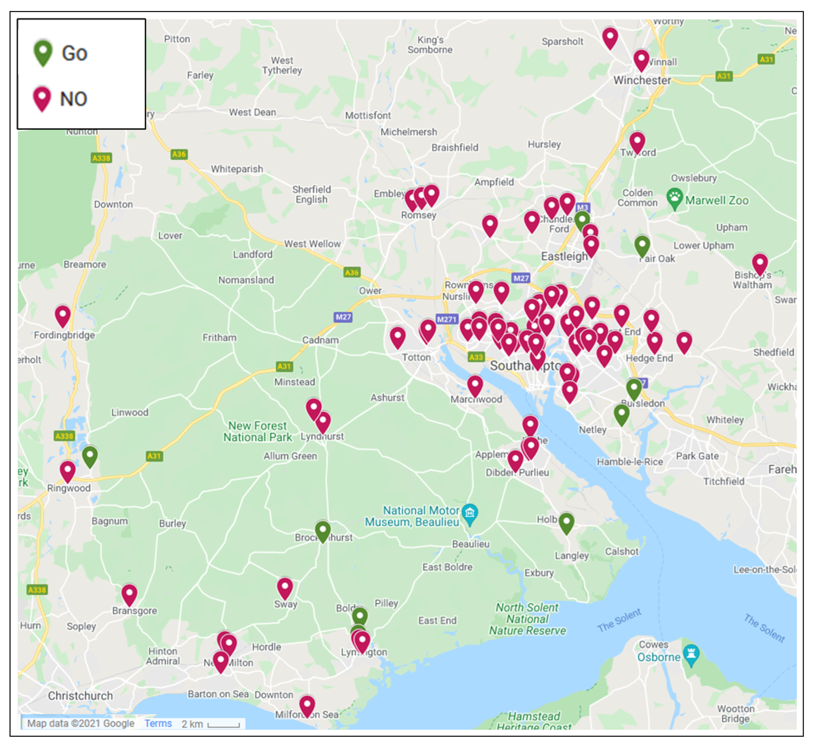
2.3. Drone-Van Comparisons

Subsequent to the analysis of fatality rates in both road and drone transport modes, a comparison between the two modes was made in terms of risk level for each O-D pair, and the effect this could have on delivery distances and times due to the circuity of routing.
Whilst the analyses used empirical data for the road transport statistics, equivalent data for drones were not available due to the novelty of the technology and the lack of deployed examples with collected and publicly available statistics. The probabilistic model provides a reasonable representation of what may occur in the event of more widespread operations based on existing literature. To assist with developing literature and setting industry safety standards, a calculation of the required LoC probabilities for drones to match those of road transport was completed.

3. Results and Discussion

With the road risk data being empirically calculated and the drone risk data being a forecast, the datasets were individually analysed, before comparing the risks on the known O-D pair cases.

3.1. Road Transport Risk

Analyses of the UK Department for Transport data found that the majority (79%) of motor vehicle fatalities were car based in 2019, and only 4% were LGV based. This is somewhat to be expected, given LGVs only made up 16% of all vehicle mileage in the same period; however, an average of 76 fatalities occurred per billion kilometers across all road vehicles, whilst the equivalent rate for LGVs was only 18 fatalities per billion kilometers, suggesting that LGVs are much safer than road transport more generally. This difference may be due to the more stringent regulations on commercial vehicles around speed limitations, maintenance, and training. Additionally, with LGVs being commercial vehicles, they typically operate during the daytime, when driving is statistically safer [47].
Discriminating by different road classes continues this trend, with LGVs resulting in 59% fewer fatalities (per billion kilometers) than all motor vehicles on motorways, 75% fewer fatalities on A-roads, and 81% fewer fatalities on minor roads (Figure 4). The findings suggest that motorways are statistically safer per kilometer, in line with government publicity [48], though only 19.8% of all motor vehicle mileage (19.6% of van mileage) is completed on this road class; thus, typical journey fatality rates are higher.
Investigating the effects this has on the journeys from the identified origin locations demonstrates that routes which use motorways and major roads proportionately more than minor roads will have a lower risk for the total distance travelled (Table 2). The highest risk delivery is from Lymington Hospital (149 fatalities per bn. trips for van, 603 for all motor vehicles), whilst the safest is from Boyatt Wood Surgery (38 fatalities per bn. trips for van, 159 for all motor vehicles).

3.2. Drone Transport Risk

Drone path calculations at each threshold resulted in a large range of fatality rates and travel distances (Figure 5, Table 3). At a lower risk threshold, the highest risk delivery is from Lymington Hospital (Surgery 7). As the risk threshold increases, delivery from Boyatt Wood (Surgery 3) becomes the highest risk, and at the highest threshold (most risky), delivery from Blackfield (Surgery 1) presents the most risk. This could be expected, as the high risk flight path from Blackfield passes directly over Southampton city centre, where significant populations are present. Equally, at the low risk threshold, longer distance flights (e.g., from Lymington Hospital) would incur a higher total risk.

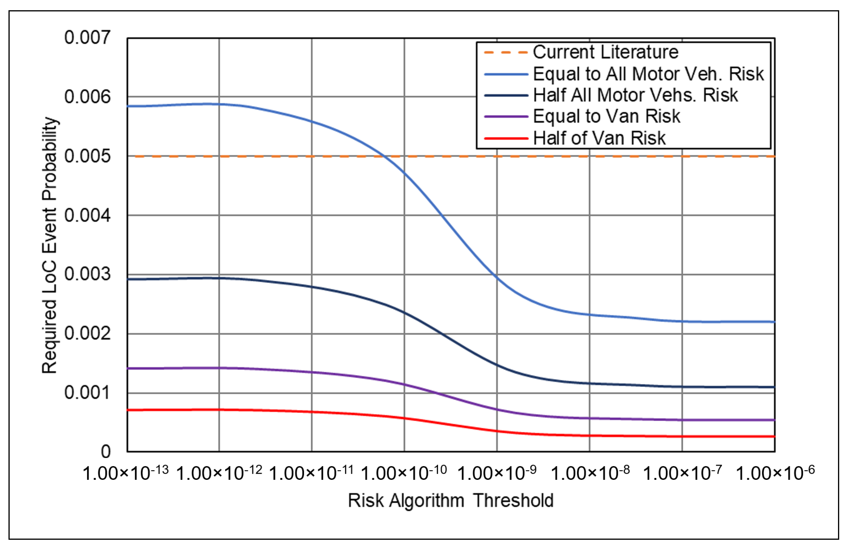
3.3. Drone-Van Risk Comparison

Comparing these findings in a more widely understood format, fatalities per billion journeys, it becomes clear that using LGVs in this setting would be safer than using a drone with a LoC probability of 5 × 10 3 per flight-hour (Figure 6). For all origins, LGV transport is safer than even the most risk-averse drone route, by a factor of 1.87 to 12.73 (i.e., 1.87 more fatalities by drone than by road). Where drone flights pass directly over urban (highly populated) areas, the fatality prediction is significantly higher, as seen in the peaks of Figure 6, which correspond to city overflight (Figure 5).
This would suggest that for freight transport, it is advisable to use LGVs from a safety perspective, if the widely cited 5 × 10 3 events per flight-hour failure rate is realised [16,39]. Whilst there may be benefits of using drones in terms of speed, the societal cost of safety and the resulting impact on public opinion may outweigh the benefits.
When considering all motor vehicles, they are safer than the lowest risk threshold drone path for some journeys (e.g., Boyatt Wood, 3.06 times safer), and more risky in others (e.g., Lymington Hospital 2.17 times less safe). These findings are to be expected based on the road transport analysis, as those surgeries which are more rural (e.g., Lymington Hospital), and involve a greater proportion of minor roads to be served, are generally those that are less safe than drones, which would fly over lower population density areas for a comparable journey. It should also be noted that, regardless of routing, LGVs are safest in all cases, based on the parameters defined in Table 3.
If an average fatality rate is taken across all journeys at each threshold setting, an S-curve becomes apparent (Figure 7), with a maximum fatality rate (894 fatalities per billion journeys) being achieved when routing is set to the highest risk threshold ( 1 × 10 6 ), and a minimum (337 fatalities per billion journeys) being achieved when routing is set to the lowest risk threshold ( 1 × 10 13 ). The plateauing shape of this curve suggests that risk levels are approximately bounded and cannot be improved or worsened for these case study locations. The upper fatality rate will be bounded by the trajectories which are direct (straight-line), whilst the lower rate will be bounded by the risk required to access the hospital (i.e., some risk will always be present if the end destination is to be reached).
Based on these comparisons, the equivalent threshold for motor vehicles more generally would be approximately 6.31 × 10 11 . Meanwhile, there is no realistic equivalent risk algorithm threshold for a van as the mean fatality rate falls outside of the bounds of the S-curve in the tested examples.
Investigating the sensitivity in LoC failure rates, it was possible to determine the required LoC probabilities that drones would need to achieve to be as safe as LGVs; or twice as safe, as suggested to be a criteria for the wider adoption of urban air mobility systems [33]. To achieve a risk level equal to vans (i.e., equal fatality rate), drones would need to experience an LoC event probability of 5.35 × 10 4 per flight-hour at the highest (most risky) tested threshold, and 1.42 × 10 3 per flight-hour at the lowest (least risky) tested threshold. Likewise, to achieve levels twice as safe (i.e., half the fatality rate) as vans, the LoC probabilities would need to be 2.67 × 10 4 per flight-hour at the highest tested threshold, and 7.09 × 10 4 per flight-hour at the lowest tested threshold. To achieve a level twice as safe as all road vehicles, the LoC probabilities would need to be 1.10 × 10 3 per flight-hour (highest theshold) and 2.92 × 10 3 per flight-hour (lowest threshold). The required rates for equivalence are presented in Figure 8.
In the wider aviation context, general and commercial aviation (combined) have been cited to target an LoC probability of 1 × 10 6 [16]. It is unlikely that this level would be achieved by drone operations due to there being fewer, less rigorous boundaries for commencing operations (e.g., pilot training, etc.). Should more specialist operations be considered in isolation, such as those operating under a ‘Certified’ status in Europe, a comparable level may be reached as regulations require higher standards of air-worthiness and training [49]. These results also mean that a less reliable drone can still achieve a risk level equal to a more reliable drone by taking a lower risk path.

3.4. Distance and Circuity Effects

In the results of the flight planning, it is clear that some risk thresholds result in considerably more direct flights than others (Figure 5), and in some cases the road transport option is shorter (Table 4). This can have significant impacts on (a) whether drone services are possible with the battery/fuel capacity of the drone; and (b) the time required to complete the delivery, along with any benefits of the often perceived faster travel speeds.
Calculating the circuity factor for each threshold, it becomes apparent that the highest risk threshold gives routes that are direct (Cicuity Factor = 1.00), whilst the lowest risk threshold generates routes with a Circuity Factor of 3.737 (Table 5, Figure 9). Assuming no wind and the assumed cruise speed of 35 m/s, a 10 km journey would take 4 min 46 s at the highest risk threshold, whilst the equivalent at the lowest theshold would take 17 min 48 s. Road travel times on an equivalent journey will vary based on vehicle and road speed limits, though at 50 km/h (31 mph) and at 70 km/h (43 mph) (average end-end speeds including any traffic), the same journey would take 15 min 22 s and 10 min 58 s, respectively.
Should the payload be large enough to require more than one drone/multiple trips to complete the consignment, the risk will multiply further. Meanwhile, the van risk would remain unchanged as it can generally carry significantly more payload than the majority of drones [50]. For example, if two Versapak medical carriers (Figure 3) need to be delivered by drone, three one-way trips trips would be required (out-back-out) before the delivery is completed; thus, the risk would be 3-times larger. The van would be capable of carrying both Versapaks in one journey, thus its risk would not multiply. It should also be noted that a need for multiple trips will further amplify any speed penalty as the full consignment is not delivered in the first shipment.
It should be noted that whilst the assumed safety and circuity benefits of drones over vans are not seen in this UK study, if similar comparisons are applied to other countries, particularly those which have less established all weather road networks, there may be considerably different findings. Due to road networks being less established and more dangerous, drone deliveries in such countries may prove to be more advantageous [28,51].

4. Conclusions

In an analysis of seven O-D pairs in the Southampton area, varying between urban and rural settings, one-way deliveries by van are seen to be consistently less risky than the equivalent deliveries by drone when widely cited drone failure rates were considered.
Variation was seen between van routes, with routes that required use of more rural and minor roads being statistically less safe (e.g., Lymington Hospital, 149 fatalities per bn. trips), and those that were more motorway and major road based being considerably safer (e.g., Boyatt Wood Surgery, 38 fatalities per bn. trips). Motor vehicles more generally were less safe than vans on all tested trips (e.g., Lymington Hospital, 149 fatalities per bn. trips).
Variation was also seen between drone routes, depending on the level of accepted risk/target risk (risk algorithm threshold). As the level of algorithm threshold increased, so did the mean fatality rate, following an upwards S-curve trend. A plateau was seen at both ends of the curve, bounded by what was deemed to be (i) the risk of the minimum flight distance flight path (maximum risk); and (ii) the minimum risk that has to be experienced in order to reach the destination. The equivalent risk threshold value for all motor vehicles was estimated to be approximately 6.31 × 10 11 , whilst no equivalent algorithm threshold existed for a van as it was safer in all cases.
When identifying the failure rates required for drones to match ground transport in terms of risk, it was found that drones would need to experience an LoC event probability between 5.35 × 10 4 per flight-hour and 1.42 × 10 3 per flight-hour to match vans, or between 2.67 × 10 4 per flight-hour and 7.09 × 10 4 to be twice as safe as vans. Comparing to all motor vehicles, a drone LoC probability between 1.10 × 10 3 per flight-hour and 2.92 × 10 3 per flight-hour would be required.
The effects of route circuity due to taking lower risk routes indicated that drones may have to travel up to 273% further than the widely assumed straight-line path; hence, flight speed may not be as beneficial as many studies suggest. Furthermore, should multiple trips be required due to insufficient payload capacity, drones may become even more risky when compared to vans with considerable payload capacities.
Whilst the absolute values of the fatality rates seen in the analyses were small, the total distance travelled in vans and potential for the use of UAS in such logistics networks highlights the importance of such a comparison. Furthermore, the approach used in this paper could be adopted for future work, using an established mode as a benchmark for accepted risk from which to compare and contrast new modes/methods with. Additionally, the probabilistic model used in this study provides a reasonable representation of widespread drone operations, though more thorough sensitivity analyses should be investigated to fully understand the failure rates required to match/better road transport for different aircraft and conditions.
In similarly developed countries, the road safety trends and circuity follow closely to the UK’s; thus, the potential increase in risk created by drone deliveries over vans (if the reliability assumed in the literature is realised) could become a problem if their usage continues to grow. Meanwhile, in developing nations, where infrastructure is generally less established and safe, drones may offer a potentially safer alternative to ground transport. When considering future applications of drone delivery technology, the level of accepted risk and the currently experienced risk should be carefully considered by policy-makers to prevent increase exposure to involuntary risk.
Where this study assumed midday flight times in the calculation of risk values, future work may seek to investigate the effect of time of day on trajectory planning and risk. The drone risk model is able to generate population density maps for different times of day, however a temporal aspect to road traffic statistics is not available.

Author Contributions

Conceptualization, A.P. and A.O.; methodology, A.P. and A.O.; software, A.P. and A.O.; validation, A.O. and A.P.; formal analysis, A.O. and A.P.; investigation, A.O. and A.P.; resources, A.O. and A.P.; data curation, A.O.; writing—original draft preparation, A.O. and A.P.; writing—review and editing, A.P., A.O., T.C. and J.S.; visualization, A.O. and A.P.; supervision, T.C. and J.S.; project administration, T.C. and J.S.; funding acquisition, T.C. and J.S. All authors have read and agreed to the published version of the manuscript.

Funding

This work is funded by the Engineering and Physical Sciences Research Council on the e-drone project grant number EP/V002619/1.

Institutional Review Board Statement

Not Applicable for this study.

Informed Consent Statement

Not Applicable for this study.

Data Availability Statement

Acknowledgments

The authors would like to thank the NHS staff at Southampton General Hospital for supplying the data used in the analysis.

Conflicts of Interest

The authors declare no conflict of interest.The funders had no role in the design of the study; in the collection, analyses, or interpretation of data; in the writing of the manuscript; or in the decision to publish the results.

References

  1. IATA. Flying Is by Far the Safest Form of Transport. 2018. Available online: https://www.iata.org/en/iata-repository/publications/economic-reports/flying-is-by-far-the-safest-form-of-transport/ (accessed on 19 July 2022).
  2. Savage, I. Comparing the fatality risks in United States transportation across modes and over time. Res. Transp. Econ. 2013, 43, 9–22. [Google Scholar] [CrossRef] [Green Version]
  3. NumberWatch. The Risks of Travel. 2000. Available online: http://www.numberwatch.co.uk/risks_of_travel.htm (accessed on 19 July 2022).
  4. Beck, L.F.; Dellinger, A.M.; O’Neil, M.E. Motor Vehicle Crash Injury Rates by Mode of Travel, United States: Using Exposure-Based Methods to Quantify Differences. Am. J. Epidemiol. 2007, 166, 212–218. [Google Scholar] [CrossRef] [PubMed]
  5. UPDWG. Medical Drone Delivery Database (MD3). 2022. Available online: https://www.updwg.org/md3/ (accessed on 4 January 2022).
  6. Pilko, A.; Sóbester, A.; Scanlan, J.P.; Ferraro, M. Spatiotemporal Ground Risk Mapping for Uncrewed Aerial Systems operations. In AIAA SCITECH 2022 Forum; AIAA SciTech Forum; American Institute of Aeronautics and Astronautics: Reston, VI, USA, 2021. [Google Scholar] [CrossRef]
  7. Koh, C.H.; Low, K.H.; Li, L.; Zhao, Y.; Deng, C.; Tan, S.K.; Chen, Y.; Yeap, B.C.; Li, X. Weight threshold estimation of falling UAVs (Unmanned Aerial Vehicles) based on impact energy. Transp. Res. Part C Emerg. Technol. 2018, 93, 228–255. [Google Scholar] [CrossRef]
  8. UK CAA. Where You Can Fly Drones | UK Civil Aviation Authority. 2021. Available online: https://register-drones.caa.co.uk/drone-code/where-you-can-fly (accessed on 27 July 2021).
  9. Jiang, C.; Blom, H.A.; Sharpanskykh, A. Third Party Risk Indicators and Their Use in Safety Regulations for UAS Operations. In AIAA AVIATION 2020 FORUM; American Institute of Aeronautics and Astronautics: Reston, VA, USA, 2020; eprint. [Google Scholar] [CrossRef]
  10. Ren, X.; Cheng, C. Model of Third-Party Risk Index for Unmanned Aerial Vehicle Delivery in Urban Environment. Sustainability 2020, 12, 8318. [Google Scholar] [CrossRef]
  11. EASA. Drones—Regulatory Framework Background. 2015. Available online: https://www.easa.europa.eu/domains/civil-drones/drones-regulatory-framework-background (accessed on 19 July 2022).
  12. OZYRPAS Consulting. Global Drone Regulations Database. 2022. Available online: https://www.droneregulations.info/index.html (accessed on 19 July 2022).
  13. Grote, M.; Pilko, A.; Scanlan, J.; Cherrett, T.; Dickinson, J.; Smith, A.; Oakey, A.; Marsden, G. Pathways to Unsegregated Sharing of Airspace: Views of the Uncrewed Aerial Vehicle (UAV) Industry. Drones 2021, 5, 150. [Google Scholar] [CrossRef]
  14. Grote, M.; Pilko, A.; Scanlan, J.; Cherrett, T.; Dickinson, J.; Smith, A.; Oakey, A.; Marsden, G. Sharing airspace with Uncrewed Aerial Vehicles (UAVs): Views of the General Aviation (GA) community. J. Air Transp. Manag. 2022, 102, 102218. [Google Scholar] [CrossRef]
  15. Guglieri, G.; Lombardi, A.; Ristorto, G. Operation Oriented Path Planning Strategies for Rpas. Am. J. Sci. Technol. 2015, 2(6), 321–328. [Google Scholar]
  16. Dalamagkidis, K.; Valavanis, K.P.; Piegl, L.A. On unmanned aircraft systems issues, challenges and operational restrictions preventing integration into the National Airspace System. Prog. Aerosp. Sci. 2008, 44, 503–519. [Google Scholar] [CrossRef]
  17. USA FAA. AC 25.1309-1A—System Design and Analysis—Document Information. 1988; Last Modified: 2021-09-22T13:37:12-0400. Available online: https://www.faa.gov/regulations_policies/advisory_circulars/index.cfm/go/document.information/documentid/22680 (accessed on 19 July 2022).
  18. Kim, E.; Long, K. Amazon Prime Air to Recruit Thousands to Test Drone Delivery This Year. 2022. Available online: https://www.businessinsider.com/amazon-beta-test-drone-delivery-prime-air-california-texas-2022-3?r=US&IR=T (accessed on 9 November 2022).
  19. Clothier, R.; Walker, R. Determination and Evaluation of UAV Safety Objectives. In Proceedings of the 21st International Conference on Unmanned Air Vehicle Systems, Athens, Greece, 15–18 June 2021; Hugo, S., Ed.; University of Bristol: Bristol, UK, 2006; pp. 18.1–18.16. [Google Scholar]
  20. Clothier, R.A.; Greer, D.A.; Greer, D.G.; Mehta, A.M. Risk Perception and the Public Acceptance of Drones. Risk Anal. 2015, 35, 1167–1183. [Google Scholar] [CrossRef] [PubMed]
  21. Skjong, R.; Eknes, M. Economic Activity and Societal Risk Acceptance. In Proceedings of the European Conference on Safety and Reliability ESREL, Torino, Italy, 16–20 September 2001; p. 9. [Google Scholar]
  22. IMO. Formal Safety Assessment. 2002. Available online: https://www.imo.org/en/OurWork/Safety/Pages/FormalSafetyAssessment.aspx (accessed on 19 July 2022).
  23. Aydin, B. Public acceptance of drones: Knowledge, attitudes, and practice. Technol. Soc. 2019, 59, 101180. [Google Scholar] [CrossRef]
  24. Smith, A.; Dickinson, J.E.; Marsden, G.; Cherrett, T.; Oakey, A.; Grote, M. Public acceptance of the use of drones for logistics: The state of play and moving towards more informed debate. Technol. Soc. 2022, 68, 101883. [Google Scholar] [CrossRef]
  25. Buczkowska, S.; Coulombel, N. Euclidean versus network distance in business location: A probabilistic mixture of hurdle-Poisson models. In Proceedings of the 55th Congress of the European Regional Science Association, Lisbon, Portugal, 25–29 August 2015; p. 22. [Google Scholar]
  26. Boyac, B.; Dang, T.H.; Letchford, A.N. Vehicle routing on road networks: How good is Euclidean approximation? Comput. Oper. Res. 2021, 129, 105197. [Google Scholar] [CrossRef]
  27. Ballou, R.H.; Rahardja, H.; Sakai, N. Selected country circuity factors for road travel distance estimation. Transp. Res. Part A Policy Pract. 2002, 36, 843–848. [Google Scholar] [CrossRef]
  28. Nelson, A.; de By, R.; Thomas, T.; Girgin, S.; Brussel, M.; Venus, V.; Ohuru, R. The Resilience of Domestic Transport Networks in the Context of Food Security—A Multi-Country Analysis: Background Paper for The State of Food and Agriculture 2021; Food & Agriculture Org.: Rome, Italy, 2021. [Google Scholar]
  29. Natural Resources and Commerce Division, Congressional Budget Office. The Current and Future Savings of Energy Attributable to Amtrak: A Staff Draft Analysis; Natural Resources and Commerce Division, Congressional Budget Office: Washington, DC, USA, 1979. [Google Scholar]
  30. Kasliwal, A.; Furbush, N.J.; Gawron, J.H.; McBride, J.R.; Wallington, T.J.; De Kleine, R.D.; Kim, H.C.; Keoleian, G.A. Role of flying cars in sustainable mobility. Nat. Commun. 2019, 10, 1555. [Google Scholar] [CrossRef] [Green Version]
  31. Finley, K. Drone-Filled Skies Are Safer Than Car-Filled Streets. Wired. 2015. Available online: https://www.wired.com/2015/05/drone-safety/ (accessed on 19 July 2022).
  32. Walter, C. 4 Reasons Drones Outperform Crewed Aircraft for Industrial Inspections. 2022. Available online: https://consortiq.com/uas-resources/4-reasons-drones-outperform-crewed-aircraft-for-industrial-inspections (accessed on 10 October 2022).
  33. Commercial Drone Professional. eVTOL Air Taxis ‘Must Be Much Safer than Cars’. 2021. Available online: https://www.commercialdroneprofessional.com/evtol-air-taxis-must-be-much-safer-than-cars/ (accessed on 10 October 2022).
  34. Lampert, A. Boeing urges air taxi safety standards be as strict as for commercial jets. 2022. Available online: https://www.reuters.com/business/aerospace-defense/boeing-urges-air-taxi-safety-standards-be-strict-commercial-jets-2022-11-08/ (accessed on 14 November 2022).
  35. Oakey, A.; Grote, M.; Smith, A.; Cherrett, T.; Pilko, A.; Dickinson, J.; Ait Bihi Ouali, L. Integrating drones into NHS patient diagnostic logistics systems: Flight or fantasy? PLoS ONE, 2022; in press. [Google Scholar] [CrossRef]
  36. GraphHopper. API - Graph Hopper. 2020. Available online: https://docs.graphhopper.com/ (accessed on 28 April 2021).
  37. Department for Transport. Road Traffic Statistics (TRA). 2021. Available online: https://www.gov.uk/government/statistical-data-sets/road-traffic-statistics-tra (accessed on 19 July 2022).
  38. Department for Transport. Road Traffic Statistics—About. 2022. Available online: https://roadtraffic.dft.gov.uk/custom-downloads/road-accidents/reports/53dadb3b-4f3d-40b6-a437-8aee1382d651 (accessed on 19 July 2022).
  39. Primatesta, S.; Rizzo, A.; la Cour-Harbo, A. Ground Risk Map for Unmanned Aircraft in Urban Environments. J. Intell. Robot. Syst. 2020, 97, 489–509. [Google Scholar] [CrossRef]
  40. Melnyk, R.; Schrage, D.; Volovoi, V.; Jimenez, H. A Third-Party Casualty Risk Model for Unmanned Aircraft System Operations. Reliability Engineering & System Safety 2014, 124, 105–116. [Google Scholar] [CrossRef]
  41. la Cour-Harbo, A. Ground Impact Probability Distribution for Small Unmanned Aircraft in Ballistic Descent. In Proceedings of the 2020 International Conference on Unmanned Aircraft Systems (ICUAS), Athens, Greece, 1–4 September 2020; pp. 1442–1451. [Google Scholar] [CrossRef]
  42. Clothier, R.A.; Williams, B.P.; Hayhurst, K.J. Modelling the Risks Remotely Piloted Aircraft Pose to People on the Ground. Safety Science 2018, 101, 33–47. [Google Scholar] [CrossRef]
  43. JARUS. JARUS Guidelines on Specific Operations Risk Assessment (SORA). Technical Report JAR-doc-06. 2019. Available online: http://jarus-rpas.org/sites/jarus-rpas.org/files/jar_doc_06_jarus_sora_v2.0.pdf (accessed on 5 August 2022).
  44. Ribak, J.; Cline, B.; Froom, P. Common accidents among airport ground personnel. Aviat. Space Environ. Med. 1995, 66, 1188–1190. [Google Scholar] [PubMed]
  45. Grabowski, J.G.; Baker, S.P.; Li, G. Ground crew injuries and fatalities in U.S. commercial aviation, 1983–2004. Aviat. Space Environ. Med. 2005, 76, 1007–1011. [Google Scholar]
  46. Daniel, K.; Nash, A.; Koenig, S.; Felner, A. Theta*: Any-Angle Path Planning on Grids. J. Artificial Intelligence Res. 2010, 39, 533–579. [Google Scholar] [CrossRef] [Green Version]
  47. Regev, S.; Rolison, J.J.; Moutari, S. Crash risk by driver age, gender, and time of day using a new exposure methodology. J. Saf. Res. 2018, 66, 131–140. [Google Scholar] [CrossRef] [PubMed]
  48. Department for Transport. Reported Road Casualties Great Britain, Annual Report: 2019. 2020. Available online: https://www.gov.uk/government/statistics/reported-road-casualties-great-britain-annual-report-2019 (accessed on 17 March 2021).
  49. European Commission. Commission Implementing Regulation (EU) 2019/947 of 24 May 2019 on the Rules and Procedures for the Operation of Unmanned Aircraft (Text with EEA Relevance.), 2019. Legislative Body: MOVE, COM. Available online: http://data.europa.eu/eli/reg_impl/2019/947/oj/eng (accessed on 14 October 2022).
  50. Ford. Technical Specification—Ford eTransit. 2022. Available online: https://media.ford.com/content/dam/fordmedia/North%20America/US/product/2022/e-transit/E-Transit-Tech-Specs.pdf (accessed on 13 July 2022).
  51. Rhino Car Hire. Safest Roads in the World - By Road Deaths | Rhinocarhire.com. 2016. Available online: https://www.rhinocarhire.com/Drive-Smart-Blog/Road-Traffic-Deaths-by-Country/Worlds-Safest-Roads-by-Country.aspx (accessed on 19 July 2022).
Figure 1. Sites tested and excluded from the analysis in the Southampton area. Go indicates the site was included for service by drone.
Futuretransp 02 00051 g001
Figure 2. Fatality Risk Map of the Southampton and New Forest area for the Mugin 5 Pro drone flying at a height of 120 m.
Futuretransp 02 00051 g002
Figure 3. Typically used medical carriers, manufactured by the company “Versapak”. Centre (‘medium’) = 460 mm (w), 255 mm (D), 305 mm (H).
Futuretransp 02 00051 g003
Figure 4. Road Types Fatality Rates Compared.
Futuretransp 02 00051 g004
Figure 5. Mapped drone flight paths. Colours indicate risk threshold (red = higher, green = lower). Numbers refer to the surgeries as labelled in Table 3. Map data ©2022 Google.
Futuretransp 02 00051 g005
Figure 6. Comparison of fatality rates per billion journeys, relative to origin-destination straight-line flight distance and risk algorithm threshold. Peaks seen in the higher risk threshold plots correlate with urban overflight.
Futuretransp 02 00051 g006
Figure 7. Mean Fatality Rates for the Case Study Paths.
Futuretransp 02 00051 g007
Figure 8. Target drone LoC event probabilities to be equal to ground transportation risk levels. Half = Half of the Fatality Rate/Twice as Safe.
Futuretransp 02 00051 g008
Figure 9. Mean Circuity Factor with Increasing Risk vs. Road Travel Benchmark.
Futuretransp 02 00051 g009
Table 1. Parameters of the Mugin 5 Pro aircraft used as an example.
ParameterValue
Mass [kg]50.0
Length [m]3.5
Width [m]5.0
Horizontal Airspeed [m/s]35.0
Frontal Area [m 2 ]3.0
Ballistic Descent Drag Coefficient0.8
Glide Airspeed [m/s]25
Glide Ratio11
LoC Event Probability [h 1 ]5 × 10 3
Table 2. Distances by road class and trip fatality rate for each road journey. Destination is Southampton General Hospital in all cases.
Distances (km)Fatality Rate (Per bn. Trips)
OriginMotorwayA-Road (Major)A-Road (Minor)B-RoadOtherTotalVanAll Motor Vehs
Blackfield Health Centre 00.6618.7501.9921.37120490
Blackthorn Health Centre 005.160.17.0412.2761287
Boyatt Wood Surgery 3.202.903.149.2238159
Stokewood Surgery 3.204.223.181.9612.5355236
Cornerways Med. Centre 10.8914.90.4903.7429.96130502
New Forest Med. Group 00.6617.860.991.3820.85116479
Lymington Hospital 00.6623.9501.7526.33149603
Table 3. Fatality rates per billion journeys for each threshold/mode and origin. Destination is Southampton General Hospital in all cases.
Threshold
Origin 1.00 × 10 6 3.98 × 10 8 1.58 × 10 9 6.31 × 10 11 2.51 × 10 12 1.00 × 10 13 VanAll Vehs
(1) Blackfield Health Centre 13401316958387304288120490
(2) Blackthorn Health Centre 1237118090648937634661287
(3) Boyatt Wood Surgery 45045045251645348638159
(4) Stokewood Surgery 83477747838338641855236
(5) Cornerways Med. Centre 113111311024304278275130502
(6) New Forest Med. Group 589589603330285268116479
(7) Lymington Hospital 680680680361291278149603
Table 4. Distance Travelled for Each Threshold/Mode. 1.00 × 10 6 is equal to straight-line flight in all cases.
Threshold
Origin 1.00 × 10 6 3.98 × 10 8 1.58 × 10 9 6.31 × 10 11 2.51 × 10 12 1.00 × 10 13 Road
Blackfield Health Centre13.413.414.230.235.741.221.37
Blackthorn Health Centre9.79.814.822.146.853.612.27
Boyatt Wood Surgery7.17.27.31219.441.49.22
Stokewood Surgery9.29.29.811.327.354.812.53
Cornerways Med. Centre25.325.325.430.131.632.729.96
New Forest Med. Group16.716.716.725.328.132.720.85
Lymington Hospital19.919.919.929.832.83726.33
Table 5. Mean Circuity Results for Each Threshold/Mode.
Threshold/ModeMean Circuity Factor
1.00 × 10 6 1.000
3.98 × 10 8 1.004
1.58 × 10 9 1.104
6.31 × 10 11 1.566
2.51 × 10 12 2.517
1.00 × 10 13 3.737
Road1.280
Publisher’s Note: MDPI stays neutral with regard to jurisdictional claims in published maps and institutional affiliations.

