Article

Digitally Decoding Heritage: Analyzing the Sellman Tenant House Through HBIM and Digital Documentation Techniques

by
Botao Li
1,*,
Danielle S. Willkens
1,
Shadi Alathamneh
2,
Sharon C. Park
3 and
Junshan Liu
2,*
1
School of Architecture, Georgia Institute of Technology, Atlanta, GA 30332, USA
2
McWhorter School of Building Science, Auburn University, Auburn, AL 36849, USA
3
Office of Planning, Design, & Construction, Smithsonian Institution, Washington, DC 20024, USA
*
Authors to whom correspondence should be addressed.
Virtual Worlds 2025, 4(1), 10; https://doi.org/10.3390/virtualworlds4010010
Submission received: 1 January 2025 / Revised: 6 March 2025 / Accepted: 10 March 2025 / Published: 18 March 2025

Abstract

:
This study presents a comprehensive digital documentation and preservation effort for the Sellman Tenant House, a historic structure once part of the 18th-century Sellman Plantation in Maryland, USA. This research employs an array of digital technologies, including Terrestrial Laser Scanning (TLS), digital photogrammetry, Unmanned Aerial Vehicles (UAVs), 3D virtual tours, and Heritage Building Information Modeling (HBIM), to document and analyze the construction techniques and historical evolution of the house. Given the absence of written records detailing its original construction, this study utilizes data from these digital documentation methods to explore the building’s structure and determine its construction timeline and methods. Additionally, this research investigates the potential of HBIM as an educational platform to enhance public understanding of heritage buildings by creating interactive and accessible digital models. The findings highlight the effectiveness of combining digital tools to decode vernacular construction and showcase the potential of HBIM in preserving and interpreting historic buildings for diverse audiences, especially for educational purposes. This research contributes to the growing field of digital heritage preservation by showcasing a case study of integrating multiple digital technologies to study, preserve, and promote understanding of a culturally significant yet understudied structure.

1. Introduction

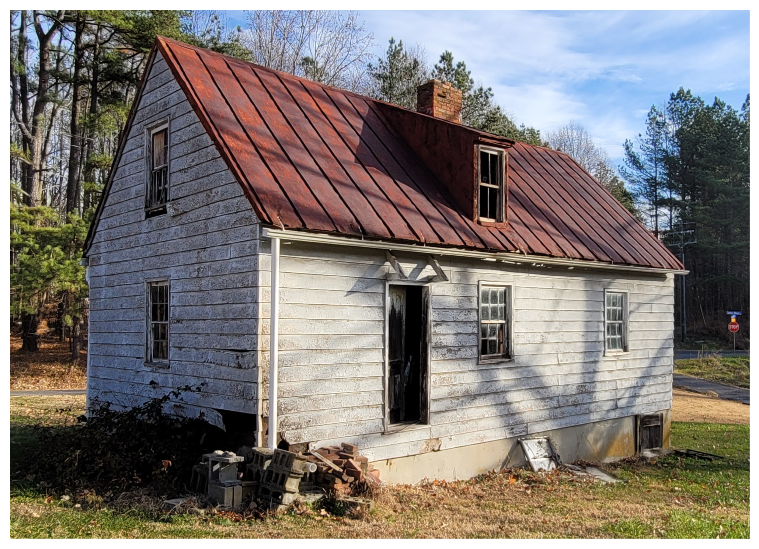
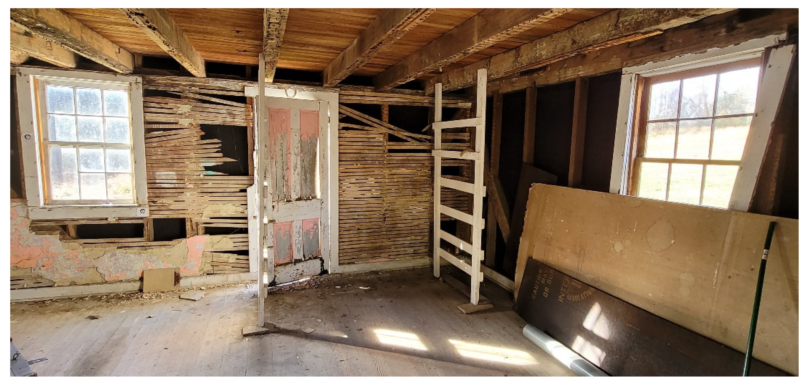
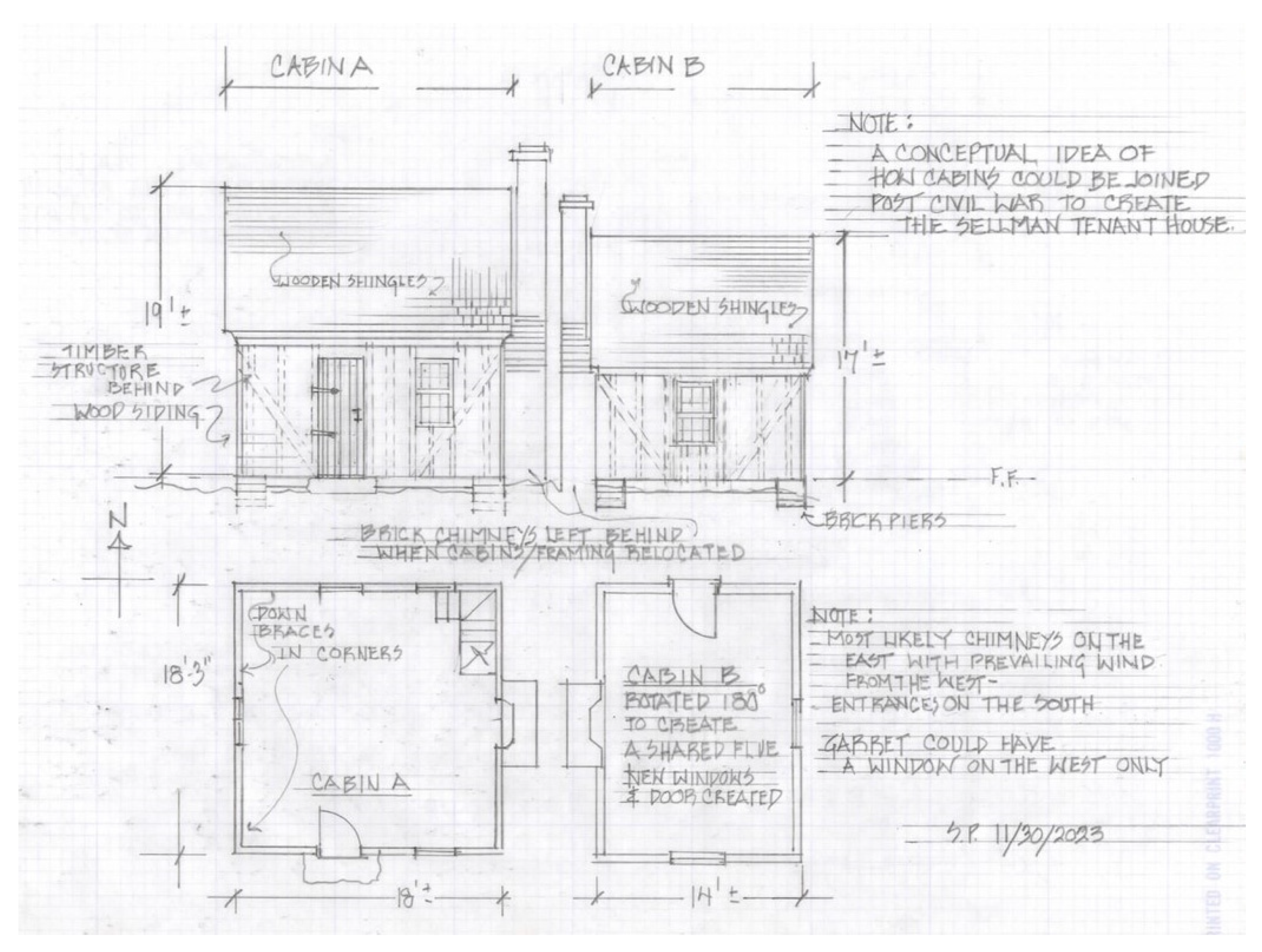
1.1. The Sellman Tenant House

The Sellman Tenant House (STH), located on the property of the Smithsonian Environmental Research Center (SERC) in Edgewater, Maryland, is a valuable piece of American heritage that captures the architectural and social history of the region. Believed to have been built in the 1870s or 1880s, as shown in Figure 1 and Figure 2, the STH is thought to have been constructed using salvaged materials from older structures. Architectural historians suggest that the house may have been built from the remains of two older houses that were joined together, possibly incorporating elements from earlier slave quarters on the Sellman Plantation (Figure 3). This “cobbled” construction style reflects the resourcefulness and economic constraints of the era, where builders often reused materials from existing structures in the 18th and 19th centuries in the US [1,2]. The hand-hewn timbers used in the STH are believed to date back to between 1780 and 1820, supporting the theory of recycled construction materials [3].
The STH stands as a testament to the transition from an enslaved workforce to tenant farming in the South after the American Civil War [4,5,6]. During the period between 1735 and 1864, approximately one hundred enslaved people worked on the Sellman family’s plantation, but the original structures that housed them no longer remain. Following the war, the Sellman family adopted a system of tenant farming and farm laborers, a shift that saw both black and white tenant farmers and laborers working the land. Tenant farmers paid rent to landowners in exchange for the use of their land, while farm laborers rented houses, such as the STH, on the farmers’ lands [3]. This two-story, 850-square-feet (approximately 79 square meters) house’s architectural characteristics—its larger size, sashed windows, and plaster finish—indicate that it was constructed by someone with access to capital, distinguishing it from more rudimentary tenant houses of the period [7,8]. The house never had electricity or running water and remains essentially unaltered from its late nineteenth-century appearance, offering a rare glimpse into the living conditions of its inhabitants. Notably, it has survived largely intact, without significant renovations or modernizations, preserving much of its original fabric.
Throughout its history, the STH has housed various occupants, from the Donnell family in the 1940s to the African American Sharp family in the early 1960s, reflecting the changing social and economic dynamics of the region. After a fire in 1965, it was then left vacant and subsequently used for storage [3]. Today, the STH remains a significant artifact for understanding post-Civil War tenant farming in Maryland and the broader socio-economic transformations of the era. As one of the few surviving structures from this period, it offers valuable insights into the lives of tenant farmers and farm laborers, whose contributions have often been overlooked in historical narratives. Preserving and studying the STH enables researchers and historians to recover these histories and analyze the physical evidence that remains, even as other traces of this landscape gradually disappear. Despite its historical significance, written records related to the STH are scarce, making it difficult to determine precise construction dates, ownership transitions, and structural modifications over time. This lack of documentation highlights the importance of this research, as digital documentation and Heritage Building Information Modeling (HBIM) offer a means to reconstruct and analyze its architectural evolution. By integrating historical research with digital heritage technologies, this study seeks to interpret the construction techniques, material usage, and spatial organization of the STH, contributing to a deeper understanding of the region’s vernacular architecture and socio-economic history.

1.2. Architectural Heritage Documentation and Preservation

Architectural heritage serves as a tangible connection to our past, reflecting the architectural innovations, craftsmanship, and societal values of the times in which it was constructed. It acts as a physical archive of history and bridges the gap between present generations and their cultural roots. Within this framework, the role of heritage documentation becomes critically important. These records play a pivotal role in safeguarding the architectural identity of societies and provide vital clues for understanding the evolution of architectural styles, materials, and construction techniques. Such knowledge is crucial for preservation, restoration, and education.
Preservationists and conservationists rely heavily on heritage documentation, such as drawings, photography, and written records and reports, to guide their efforts, as accurate and detailed records of built heritage structures are essential for making informed decisions about restoration, repair, and maintenance [9]. They provide architects and builders with the precise information required to recreate or restore intricate architectural features. Architectural historians and researchers also turn to these records as primary sources for uncovering stories and significance behind the historic structures. They investigate the drawings, photographs, and historical reports in the documentation archives to interpret the architectural language of the past. This, in turn, informs people’s understanding of cultural shifts, technological advancements, and artistic movements [9,10].
Furthermore, educators and students in the fields of architecture, history, and preservation also benefit from heritage documentation [11]. The records serve as a pedagogical resource, offering real-world examples of architectural styles and construction techniques. By providing a tangible connection between theoretical concepts and practical applications, the documentation enriches educators’ and students’ academic and professional development by enabling them to examine the details of historic structures, even in the absence of physical access.
Digital documentation has become critical in architecture, preservation, and cultural heritage management. As stated in their study, Liu et al. [12] claimed that traditional methods of documenting historic structures, such as manual measurements, drawings, and field notes [13], are often time-consuming, less accurate, and challenging to store. In contrast, digital technologies, including Terrestrial Laser Scanning (TLS), Digital Terrestrial Photogrammetry (DTP), and Unmanned Aerial Vehicles (UAVs), offer a more efficient, precise, and comprehensive means of capturing buildings’ physical attributes and condition [12,14,15,16]. These technologies enable the creation of high-resolution, three-dimensional (3D) models that provide unparalleled detail and accuracy, facilitating a deeper analysis of construction methods, material use, and structural integrity.
For the STH, digital documentation is particularly valuable due to the absence of written records about its original construction and modifications. By employing a range of digital tools, this study aims to capture the full extent of the building’s architectural and structural features, from the overall structure to the finer construction details. Moreover, digital documentation supports long-term preservation by creating a permanent, highly detailed record of the building’s current state, which can be used for future research, restoration, and conservation planning [17,18].
Beyond its technical benefits, digital documentation also plays a crucial role in public engagement and education [19,20]. Digital models and virtual tours can make heritage sites accessible to a broader audience, overcoming geographical and physical limitations. They provide interactive and immersive experiences that help the public understand the historical significance and architectural complexity of heritage buildings, fostering greater appreciation and support for their preservation.

1.3. Research Objectives and Significance

This study has two primary objectives. The first is to develop and evaluate an optimized workflow for the digital documentation of the STH. While previous studies have explored the application of these individual technologies in heritage preservation [21,22], there remains a gap in research concerning their integration into a unified workflow. This study aims to bridge this gap by demonstrating a multi-technology documentation workflow for an underrepresented vernacular structure. This involves integrating multiple digital technologies, including TLS, DTP, UAVs, and 3D virtual tour creation tools, to establish a comprehensive and efficient process for capturing the building’s physical attributes and conditions. The goal is to identify the best combination of these technologies to produce high-quality, accurate, and cost-effective documentation. This workflow can serve as a model for documenting other heritage buildings, especially those with limited historical records. By streamlining the stages of data acquisition, processing, and integration, this study aims to show how digital documentation can improve the understanding and preservation of heritage structures, contributing to digital heritage management.
The second objective is to explore the potential of HBIM as an innovative tool for public engagement and education. While HBIM has traditionally been used for conservation and structural analysis, its role in public interpretation remains underexplored. By linking HBIM models with interactive virtual tours, this study illustrates how digital heritage documentation can go beyond professional use and become an educational resource accessible to a broader audience. This integration is particularly relevant for historic structures like the STH, which lacks extensive written records and requires alternative means of historical interpretation.

1.4. Abbreviations

This paper uses abbreviations to refer to various terms and concepts. To avoid confusion and ensure clarity, a list of abbreviations used in this article and their corresponding meanings are included:
  • AI: Artificial Intelligence,
  • AR: Augmented Reality,
  • BIM: Building Information Modeling,
  • DTP: Digital Terrestrial Photogrammetry,
  • DSLC: Digital Single-Lens Reflex Camera,
  • HBIM: Heritage Building Information Modeling,
  • LoD: Level of Development,
  • RC: Reality Capture,
  • SERC: Smithsonian Environmental Research Center,
  • SI: Smithsonian Institution,
  • STH: the Sellman Tenant House,
  • TLS: Terrestrial Laser Scanning,
  • UAV: Unmanned Aerial Vehicle,
  • VR: Virtual Reality, and
  • VT: Virtual Tour.

2. Literature Review

2.1. Reality Capture (RC) Methods in Heritage Preservation

Reality capture (RC) technology has become an essential tool in heritage preservation, offering new possibilities for recording, analyzing, and interpreting historic structures. Traditional methods, such as manual measurements, drawings, and photographs, often fall short of providing the level of detail and accuracy required for comprehensive heritage documentation [23,24,25]. Digital technologies, including TLS, DTP, UAVs, and 3D VTs, have transformed the field by enabling more precise and efficient data capture [26,27].

2.1.1. Terrestrial Laser Scanning (TLS)

TLS is a widely used technology in heritage documentation and preservation that captures high-resolution 3D data by emitting laser beams and measuring their reflection from surfaces [28]. TLS creates highly accurate point clouds that detail the geometry of a building, capturing fine features with precision. This method is particularly useful for documenting complex architectural details and large-scale heritage sites, providing a digital record that can be analyzed for structural integrity and conservation planning [29,30]. Figure 4 illustrates the principle of TLS and the 3D point cloud of a historical building captured using the technology.

2.1.2. Digital Terrestrial Photogrammetry (DTP)

DTP involves taking multiple overlapping photographs of a structure from different angles and using software to create a 3D model from these images. It is a cost-effective and flexible method, suitable for capturing both small fine details and entire buildings [32]. Digital photogrammetry has been increasingly used in heritage studies due to its ability to produce high-quality, textured 3D models that can be used for visualization, analysis, and archiving [21,33].

2.1.3. Unmanned Aerial Vehicles (UAVs)

UAVs, commonly known as drones, have added a new dimension to digital documentation by enabling aerial surveys of heritage sites. UAVs can be equipped with high-resolution cameras, infrared cameras, laser scanners, and other sensors, providing detailed aerial imagery and 3D data that complement ground-based scanning techniques [34,35]. UAVs are particularly useful for capturing hard-to-reach areas, such as rooftops or upper sections of large structures, that are difficult to document with ground-based methods [22,36].

2.1.4. Virtual Tours (VTs)

3D VT technology creates immersive, interactive experiences of heritage sites by capturing high-resolution and 360-degree imagery. It allows users to virtually “walk through” a heritage site, exploring its features from different angles as if they were there in person [37,38]. These tours can include interactive elements like hotspots with additional information about specific areas, historical context, or architectural details, providing a rich educational experience. VTs make heritage sites accessible to a global audience, overcoming physical or geographical limitations. This is especially important for sites that are remote, restricted, or too fragile for regular visits.

2.1.5. Multi-Method Approach

An integrated approach combining multiple RC methods has proven highly effective in heritage documentation [31]. As shown in Table 1, each method has its own strengths and limitations, and by using them in tandem, practitioners can achieve a more comprehensive and detailed understanding of a site [39,40,41]. For example, TLS provides high accuracy and precision in capturing the fine details of complex architectural features, but it may be limited in covering larger areas or capturing overhead views. DTP contributes by offering high-quality textured models that enhance visualization and interpretation, especially for decorative elements and surface textures. In contrast, UAVs can quickly capture aerial perspectives and hard-to-reach areas, such as rooftops or high portions of façades, providing complementary data that fill gaps left by ground-based methods. Although numerous studies have explored the application of individual RC technologies in heritage documentation, few have systematically combined TLS, Matterport, UAVs, and photogrammetry into a unified workflow [42,43]. This study contributes to the field by refining a multi-method documentation approach that enhances accuracy, minimizes technological limitations, and offers a replicable workflow for historic sites with limited records.
As Yastikli [43] indicated that this multi-method approach improves the accuracy and completeness of documentation and facilitates cross-validation of data, where information from one method can verify or enhance the findings from another. Additionally, it allows for more adaptive strategies in data capture, where the choice of methods can be adjusted based on specific site conditions, preservation goals, and available resources [42].

2.2. HBIM in Heritage Documentation and Analysis

HBIM is an innovative extension of traditional Building Information Modeling (BIM) tailored explicitly for historic structures. HBIM integrates geometric, historical, and contextual data into a single, comprehensive digital model, providing a dynamic platform for documenting, analyzing, and managing heritage assets [44]. In heritage preservation, HBIM offers several advantages over conventional methods. It enables the creation of highly detailed 3D models that include the structure’s physical characteristics and historical and cultural context. This holistic approach allows a deeper understanding of construction techniques, material choices, and changes made over time [45,46,47]. In addition, HBIM is adaptable, allowing for continuous updates as new data become available, making it an invaluable tool for ongoing preservation and adaptive reuse projects [48,49,50].
HBIM also enables advanced analysis through simulations, such as structural integrity assessments [51] and material behavior studies [52]. These capabilities allow researchers to assess environmental impacts, identify potential risks, and plan preservation interventions with higher precision and accuracy. By offering a dynamic environment for these analyses, HBIM helps heritage professionals make more informed decisions in maintaining and restoring historic sites.

2.3. HBIM’s Potential as an Educational and Interpretive Tool

HBIM has shown significant potential as a tool for education and interpretation in heritage preservation. Several studies have demonstrated that HBIM can bridge the gap between technical documentation and public engagement by creating accurate yet accessible digital models of historic structures [53,54]. Research has shown that HBIM can be used to develop interactive educational resources that allow users to explore historical buildings in detail, learning about their architectural features, construction techniques, and historical significance [55]. For example, in their review article, García et al. [54] summarized that VTs based on HBIM models can provide immersive experiences that enable users to “walk through” a heritage site, examine its components up close, and interact with embedded information.
Moreover, HBIM has been utilized to create interpretive materials that support heritage education programs, museum exhibits, and community outreach initiatives [56]. By combining accurate RC datasets with engaging storytelling, HBIM can make complex historical information more understandable and appealing to the general public. This approach has proven to be particularly effective in reaching younger audiences and those who may not have a strong background in architectural or historical studies [57].
This study builds upon previous work by integrating HBIM with interactive VT elements to explore its potential as an educational tool. Future research could further validate these approaches through user feedback and engagement metrics.

3. Methodology

The STH project was conducted by an interdisciplinary team comprising historic preservation specialists, architectural historians, digital heritage experts, and HBIM modelers. Historians and preservation specialists provided archival research and assessed material and structural conditions, digital heritage experts managed reality capture and data processing, and HBIM modelers translated the collected data into a structured digital environment. This collaborative approach ensured that the documentation workflow captured precise geometric data and incorporated historical significance and interpretive elements into the final model.
This project employed a comprehensive six-phase methodology aimed at documenting, preserving, and engaging the public with this historic structure. The phases were project planning, data acquisition, data processing, HBIM model development, continuous monitoring, and integration for public education and engagement. Figure 5 provides an illustration of the detailed workflow and resources utilized by the project team, capturing the essence of this project’s multifaceted approach.

3.1. Project Planning

The initial phase involved careful planning and the establishment of project objectives. The collaboration between the SI and SERC aimed to document and preserve the STH digitally. The primary goals were twofold: first, to develop a comprehensive HBIM model that would allow researchers to study the house’s historical origins and construction methods; and second, to create a public engagement platform that would make the building accessible to a broader audience through immersive virtual experiences and educational tools. These objectives laid the foundation for all subsequent project phases.

3.2. Data Acquisition

Data acquisition was conducted using a combination of RC technologies and thorough research into the historical context of the STH. TLS was performed using rigorous data acquisition and processing protocols to ensure accuracy and reliability. The team employed a FARO Focus S350 scanner (FARO, Groveport, OH, USA) and a Leica BLK360 scanner (Leica, Los Angeles, CA, USA) to capture high-resolution 3D point clouds of the interior and exterior, providing accurate geometric data. Aerial data were obtained via DJI Mavic 2 Pro (DJI, Shenzen, China) and DJI Mavic 3E (DJI, China) drones, capturing imagery of the roof and surrounding landscape. A FARO Freestyle 2 handheld scanner (FARO, USA) was used to capture intricate architectural details, ensuring that smaller elements like wooden joinery were documented. Additionally, a Matterport Pro2 3D camera (Matterport, Sunnyvale, CA, USA) was employed to create an immersive 3D VT of the house, capturing high-resolution 360-degree imagery of visual textures and architectural detail for public engagement. In addition to the geometric data, semantic information about the STH was collected through extensive archival research and field study. Historical documents and structural analysis provided key insights into the building’s material properties, construction techniques, and historical context.

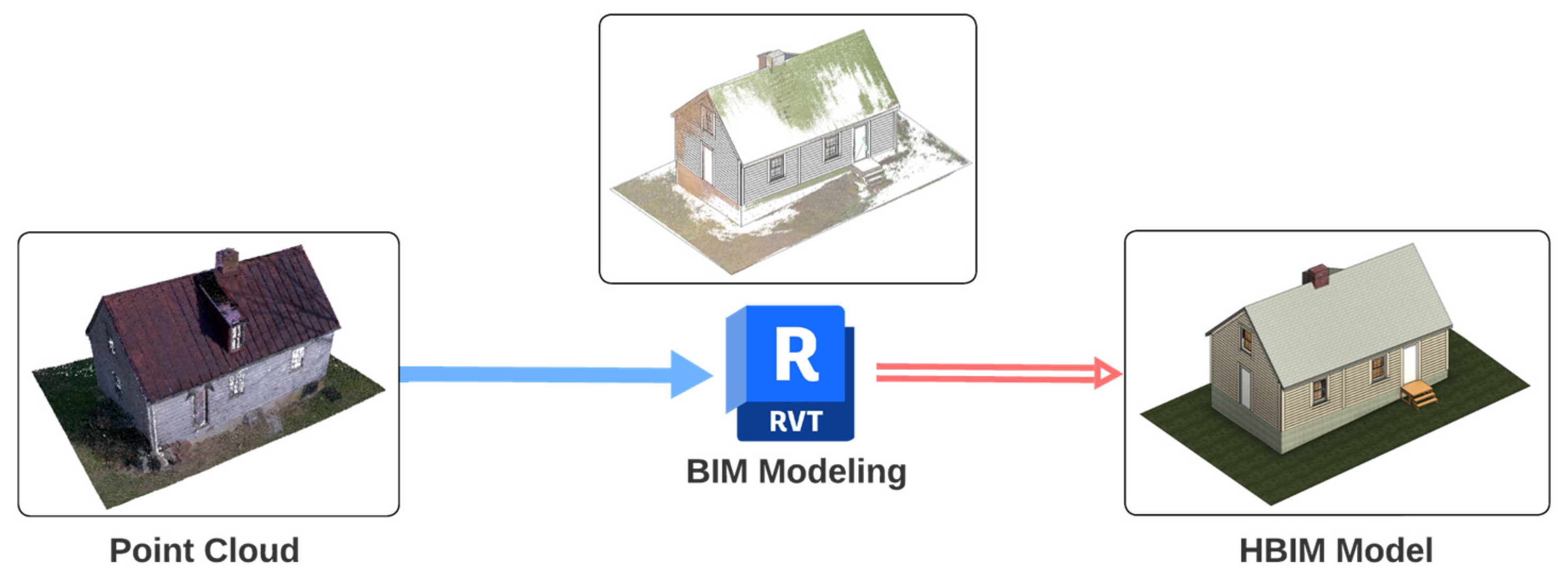
3.3. Data Processing and Model Creation

The captured data were processed by industry-standard software known for high-precision point cloud processing to create a unified, accurate representation of the STH. Point cloud data from the TLS scans were cleaned and registered by scan process software, including Faro SCENE and Leica Cyclone, forming the geometric foundation for the HBIM model. Photogrammetry was performed using Agisoft Metashape software, (Version 2.0.2) which processed aerial photos from UAVs to generate high-resolution textured models that complemented the TLS point clouds. The handheld scanner was utilized to provide detailed and close-range scans of intricate structural parts, which complemented the limitation of TLS scans. The combined point clouds from multiple sources were imported into Autodesk Revit software (Version 2023) and served as a geometric reference to construct a digital HBIM model. The combination of photogrammetry and laser scanning ensured that the final HBIM model was geometrically accurate and visually rich, integrating comprehensive data from multiple capture methods into a single cohesive digital representation.

3.4. HBIM Model Development

The HBIM model was developed in Revit using the TLS point cloud as the baseline for creating the geometric structure. Simultaneously, point clouds from other sources, including photogrammetry point clouds, handheld laser scanner point clouds, and Matterport virtual space, serviced as supplementary reference on texture and details when TLS data were insufficient. Each building element was modeled as an individual entity in Revit, with assigned semantic information, such as material properties, construction techniques, and historical context. This approach enriched the HBIM model with data beyond geometry, allowing for deeper analysis and understanding of the STH’s construction and history. Dynamo scripts in Revit were utilized to create color-coded visualizations of building elements based on construction dates, helping to track changes over time and offering a more comprehensive view of the building’s historical evolution (Figure 6). Implementing these computational scripts into the digital model enhanced the efficiency of information storage and query, which improved communication between human thoughts and model data.

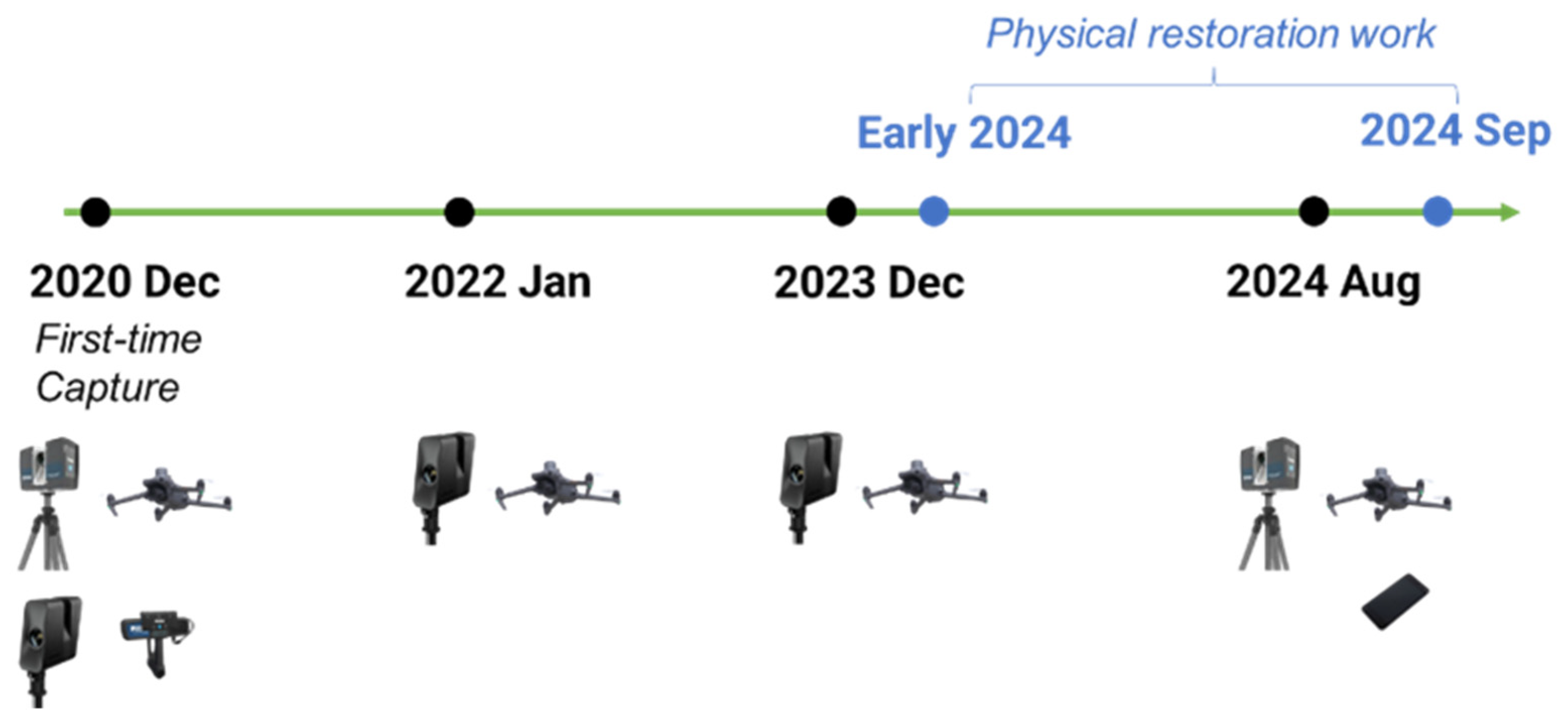
3.5. Continuous Data Capture and Monitoring

A long-term data capture and monitoring plan was implemented to ensure the ongoing preservation of the STH. Periodic reality capture using TLS, UAVs, and Matterport has been conducted to monitor building condition changes over time. This iterative process enabled the research team to track structural health, identify potential deterioration, and plan timely interventions. Meanwhile, the STH was commissioned in restoration when this iterative capture plan was established, which turned out to be another opportunity to capture the pre- and post-restoration condition of the structure (Figure 7). More comprehensive data with STH modification will be documented and can serve as a restoration study case. Furthermore, the data gathered in subsequent capture cycles will be integrated into the HBIM model to maintain an up-to-date digital record of the STH’s condition, making the HBIM model a live archive.

3.6. Public Engagement and Display

Public engagement was a central aspect of the STH project, aligning closely with the SI’s educational mission. A Matterport-based 3D VT was developed to allow users to remotely explore this heritage building, offering immersive 360-degree views and interactive hotspots enriched with detailed historical and architectural information. This VT was seamlessly integrated with the HBIM model, which served as an educational resource to showcase the building’s construction techniques, materials, and historical significance. Together, the HBIM model and VT create an engaging, interactive platform that caters to both researchers and the public, making the history and cultural value of the STH accessible to a global audience.

4. Results and Discussion

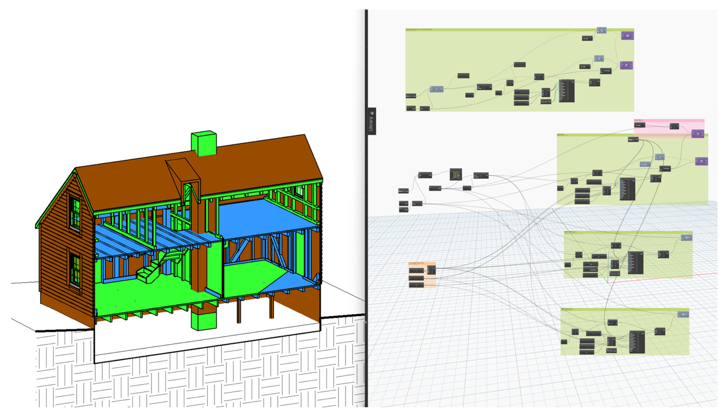
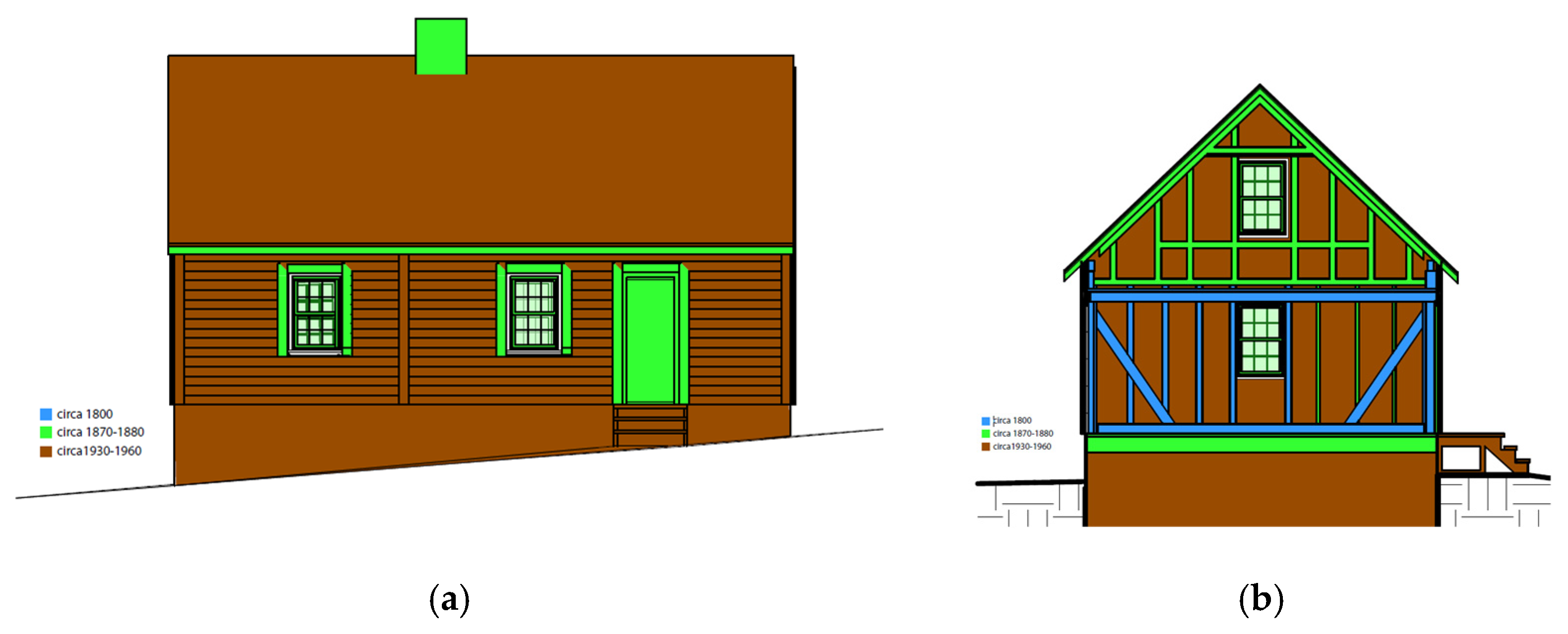
4.1. HBIM Model Achievement

The STH project successfully utilized data captured from various RC technologies—TLS, photogrammetry, UAVs, and handheld laser scanners—to construct a comprehensive HBIM model in Autodesk Revit (Figure 8). The TLS-generated point cloud served as the primary geometric reference, providing highly detailed spatial data of the building’s interior and exterior. However, due to inherent limitations in TLS, such as its inability to capture hard-to-reach areas or reflective surfaces, complementary datasets were integrated. UAV photogrammetry data offered critical aerial perspectives, particularly for documenting the roof and upper elevations, while handheld laser scanner data provided close-range details of intricate architectural elements, such as wooden joinery and damaged components. This multi-source integration overcame the constraints of any single technology, ensuring the HBIM model’s completeness and accuracy.
In addition to geometric data, non-geometric information was systematically incorporated into the HBIM model. This information, obtained from field investigations and historical archival research, was registered with individual building components. Semantic details such as material properties, structural conditions, damage assessments, and construction dates were linked to specific elements in the model (Figure 9). For example, the types of saw marks left on the wooden framing members were identified and recorded alongside damage conditions observed during field surveys. This integration of semantic data enhanced the model’s analytical capabilities and provided valuable insights into the building’s historical evolution and current condition.
Matterport technology played a dual role in this project. The captured high-resolution 360-degree imagery provided a visual reference during the HBIM modeling process, enabling the project team to verify and refine the accuracy of their work. Additionally, Matterport created an interactive VT environment, serving as a user-friendly platform for remote exploration of the STH (Figure 10). This VT enhanced the accessibility of the HBIM model, allowing both researchers and the public to engage with the STH’s digital representation. It also offers functionalities that are not provided to the public audience through HBIM, such as measurement and VR capability.
The successful integration of geometric and semantic data in the HBIM model demonstrates the potential of combining various digital documentation techniques and historical research. By utilizing advanced technologies, this project achieved a coherent and comprehensive digital representation of the STH, which serves as a robust tool for analysis, preservation, and public engagement. This achievement highlights the effectiveness of multi-source data integration in advancing the field of heritage documentation and interpretation.

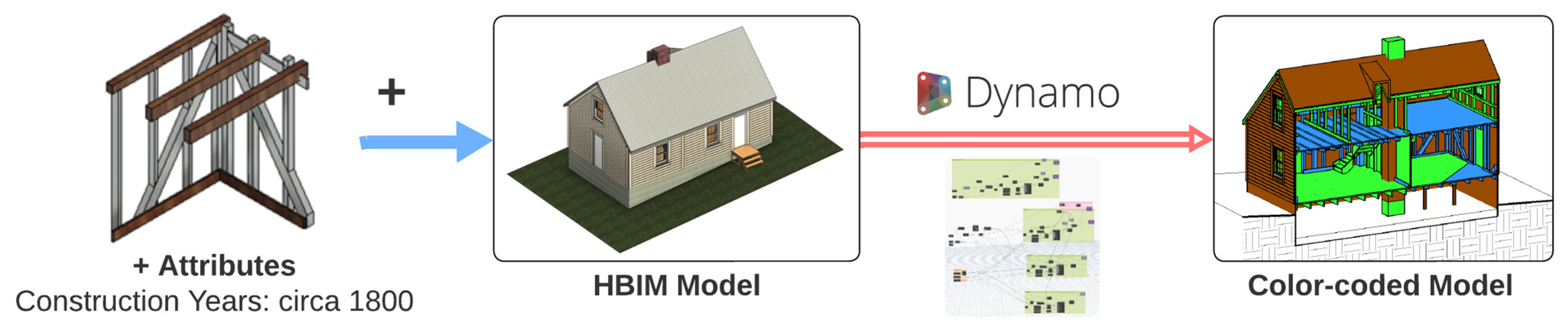
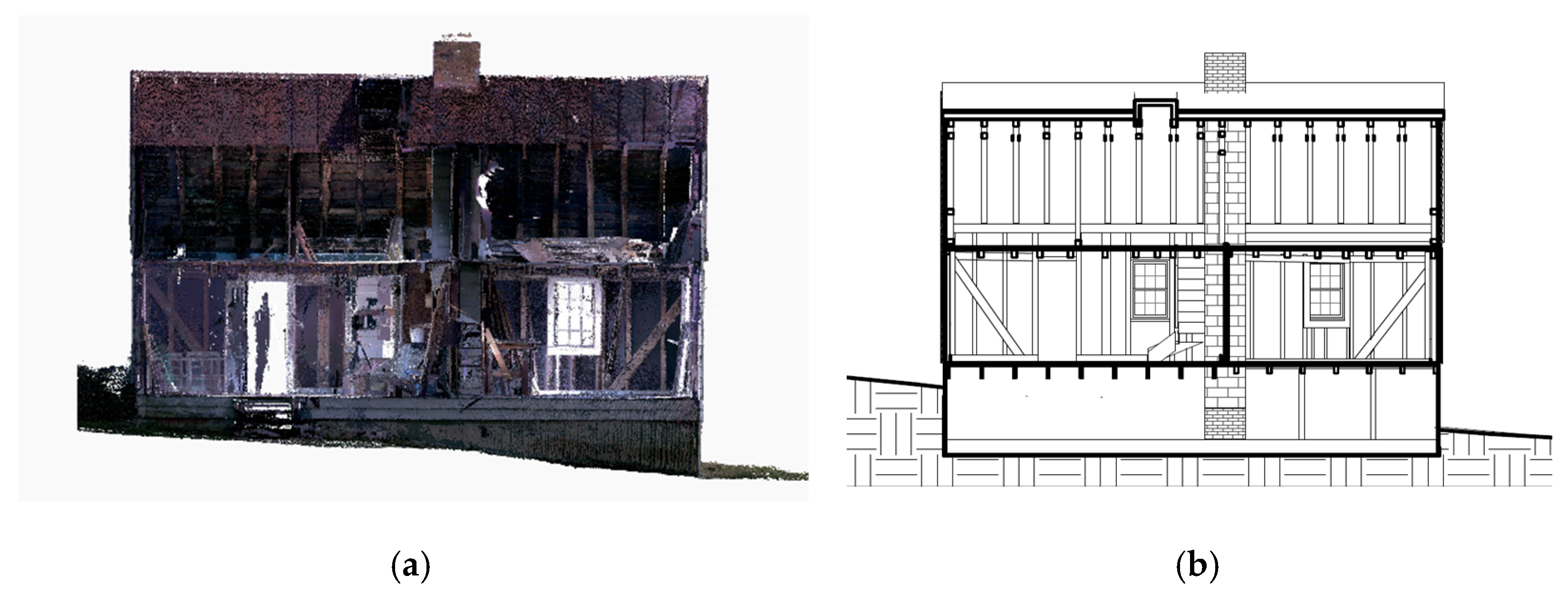
4.2. Digitally Decoding Structural Data

The digital information captured through various technologies and the constructed HBIM model were instrumental in decoding the structural data of the STH building, revealing its construction techniques and timelines. By associating holistic information with the HBIM model, each building component was linked to multiple representations, including Revit model elements, photographic records from Matterport, and isolated point cloud data. These complementary representations provided cross-references to analyze and verify the structural data, enhancing the accuracy and depth of the study.
For example, the corner structure, which exemplifies historical construction techniques, could be assessed using three distinct representations: Matterport photographic records (Figure 11a), isolated TLS point cloud data (Figure 11b), and isolated Revit model elements (Figure 11c). While the photographic records captured by Matterport offer detailed visual appearances, they are limited to fixed angles with zoom functionality. The isolated point cloud enables dynamic three-dimensional views, allowing for a deeper spatial understanding. The Revit model, however, provides advanced capabilities, such as exploded views (Figure 11d), which vividly illustrate the corner structure’s construction techniques. These exploded views offer a clear and educational explanation, directly supporting the SI’s educational outreach mission. By combining these representations, the limitations of individual formats are mitigated, resulting in robust and comprehensive information to support preservation strategies.
The STH, comprising two separate cabins, exhibited structural differences in dimensions and layout spacings between the two units. These differences were analyzed using section views of the point cloud and HBIM model, which highlighted the unique characteristics of each cabin’s structure (Figure 12). Additionally, the construction dates of individual building components were determined through architectural historians’ field investigations and examinations. This chronological information was embedded within the HBIM model, enabling detailed queries and visualizations.
Using the Revit plug-in Dynamo, scripts were developed to query the construction date information and apply color-coded visualizations to the HBIM model (Figure 13). This feature allowed users to quickly filter and change the appearance of individual building components based on their construction dates, presenting the data in a three-dimensional perspective. The color-coded model (Figure 14) utilized blue to represent circa 1800, green to represent 1870–1880, and brown to represent 1940–1960. It demonstrates that in 1870–1880, a roof unified the two sections of the house, and the fire in 1960 started a rehabilitation of the building with a new masonry flue. The brown color also shows the 20th century’s foundation and tin roof works. The color-coded visualizations could be toggled on or off instantly, returning the model to its original appearance when not in use. This interactive and efficient approach to data visualization streamlines information extraction and demonstrates significant potential for engaging with and analyzing historical data.

4.3. Model Usability and Potential

Visual representations of the STH, such as the point cloud and HBIM model, provide substantially more accurate and detailed documentation compared to written archives. These digital tools enable stakeholders to perceive and comprehend the significance of the building more effectively. The ability to generate sectional views using cutting planes in the point cloud and HBIM model offers a clear visualization of structural differences, directly supporting the theory that the STH is a combination of two cabins. Additionally, the point cloud data and Matterport VT extend the accessibility of the STH, enabling off-site visits that transcend geographical limitations, thus enhancing public engagement.
The HBIM model, equipped with Dynamo scripts, allows for rapid information queries and data visualization, making it a practical tool for analyzing and presenting complex historical data. This case study validates the reliability of the HBIM model in storing holistic information, combining geometric, semantic, and historical data into a coherent digital representation. The model’s diverse representations, including 3D visualizations, section views, and interactive features, greatly enhance public understanding of the STH’s history, structure, and cultural significance.
Moreover, HBIM serves as a powerful tool for interpretation, education, and stakeholder engagement. By embedding related information within the digital model, HBIM broadens the scope for computational analysis and simulation of historic structures. These capabilities provide valuable insights that can inform and support better decision making for preservation efforts. The integration of HBIM into heritage documentation demonstrates its potential to preserve physical and historical data and to inspire innovative approaches to the interpretation and management of cultural heritage sites.

4.4. Advantages of a Multi-Technology HBIM Workflow

The workflow presented in this study offers several advantages over traditional and existing digital heritage documentation methods. First, this research highlights the benefits of a multi-source data integration approach. For instance, TLS provides highly accurate geometric data but struggles with hand to reach surfaces and occlusions; UAV-based photogrammetry supplements this by capturing aerial views; Matterport imagery enhances the visualization of the structural materials and details, while handheld scanning ensures intricate architectural details are documented. By combining these technologies into a single HBIM model, the documentation achieves higher accuracy and completeness compared to relying on a single source.
Moreover, the educational value of HBIM in heritage interpretation has not been extensively explored in prior research. This study demonstrates that HBIM, when integrated with interactive visualization tools such as Matterport, can make historical structures more accessible to the public. Traditional heritage documentation methods primarily serve researchers and conservators, while this approach extends usability to a broader audience, including educators, students, and the general public. By incorporating color-coded construction phases, interactive section views, and explorable 3D environments, this HBIM-based methodology fosters a deeper understanding of the STH’s architectural and historical significance.
Furthermore, this study introduces a dual-purpose documentation and interpretation framework, which supports preservation efforts and also serves as an engagement tool that enables remote access and interactive learning experiences. This distinction highlights this study’s unique contribution to the field, providing a replicable model for future digital heritage initiatives.

4.5. Comparison with Similar Case Studies

The STH presents a unique case due to its lack of extensive written records and vernacular construction techniques. However, similar case studies have employed HBIM and RC technologies for heritage preservation. For example, prior research on the documentation of historic timber-framed buildings has demonstrated how TLS and photogrammetry can be effectively combined to capture structural details and material conditions [58]. Studies focusing on historic structures have also highlighted the benefits of integrating UAV imagery with HBIM for conservation planning [59,60].
Compared to these studies, the STH project contributes a distinctive workflow that integrates TLS, UAV photogrammetry, handheld scanning, and Matterport-based visualization into a single comprehensive HBIM model. Unlike previous research that primarily focused on technical documentation and conservation, this study emphasizes public engagement by utilizing HBIM as an interactive educational tool. The incorporation of color-coded historical phases, 3D virtual tours, and accessible visualization techniques expands the scope of HBIM applications beyond preservation to heritage interpretation and education.
By positioning this study alongside similar projects, it reinforces the significance of using integrated digital documentation workflows for under-documented historic structures. The insights gained from this case study can serve as a replicable model for other heritage sites that require digital reconstruction in the absence of extensive archival data.
While the study does not perform a quantitative accuracy assessment, the reliability of the collected data is ensured through industry-standard methodologies. The TLS scans were processed and registered using FARO SCENE and Leica Cyclone, both widely accepted software tools in heritage documentation. The UAV photogrammetry data were processed in Agisoft Metashape, which allows for high-precision 3D reconstruction. The FARO Focus S350 scanner, used for TLS, provides a ranging error of approximately ±2 mm, ensuring detailed geometric accuracy. The integration of multiple data sources further improves documentation reliability by cross-validating features captured from different perspectives.

5. Conclusions

5.1. Main Findings and Future Directions

The Sellman Tenant House (STH) project highlights the effectiveness of digital documentation and the potential of HBIM in preserving and interpreting historic buildings. By integrating multiple reality capture technologies, including TLS, UAVs, photogrammetry, and 3D virtual tours, this study presents an optimized workflow for documenting architectural heritage. The HBIM model, enriched with geometric, semantic, and historical data, serves as a comprehensive digital representation of the STH, enabling detailed analysis of its construction techniques and historical evolution. The absence of extensive written records highlights the importance of digital reconstruction in understanding and preserving historic structures like the STH.
The project further demonstrates the potential of HBIM as an educational platform for engaging diverse audiences. The interactive visualization capabilities of the HBIM model, combined with the immersive experience of the virtual tour, effectively bridge the gap between technical documentation and public interpretation. These tools enhance public understanding of the STH’s architectural and historical significance. Moreover, the HBIM model’s capacity to integrate diverse data sources illustrates its potential for broader applications, such as structural assessment (e.g., through finite element modeling and material testing) and safety simulations, to inform preservation strategies and facilitate educational outreach. This study serves as a benchmark for utilizing digital technologies to document and protect architectural heritage, ensuring that the stories and significance of structures like the STH endure for generations to come.
While the integration of reality capture technologies ensured detailed and accurate digital records of the STH, the combination of datasets from various technologies required extensive processing to ensure compatibility. Additionally, the use of multiple tools demanded significant expertise, financial resources, and time investment. Future research could standardize this workflow, providing a template for implementing HBIM in the documentation and preservation of a broader range of heritage sites. Although a formal accuracy assessment was beyond the scope of this research, the methodology followed the industry’s best practices to ensure data reliability. The alignment of multiple scans and validation against field observations further reinforce the credibility of the collected data. Future research could incorporate a systematic accuracy validation process to compare this workflow with conventional heritage documentation methods, further strengthening its applicability and reproducibility in similar projects. Given the relatively small size of the STH, this workflow should be applied to larger-scale or multi-site historical documentation projects to validate its scalability and versatility. Expanding HBIM models into “live archives” that evolve with recursive data capture and updates will require sustained financial and time commitments. This approach would enable long-term monitoring of structural health and the environmental impact on historic buildings. While this study highlights the potential of HBIM as a tool for public education and engagement, it does not include empirical validation through user surveys, engagement metrics, or benchmarking against traditional documentation methods. Future research could incorporate systematic evaluations of HBIM’s effectiveness in educational outreach, assessing user engagement and learning outcomes. Conducting controlled studies with user feedback, comparative studies against conventional heritage documentation methods, and evaluating engagement analytics would provide deeper insights into HBIM’s actual impact on public understanding. Addressing these future research directions will allow HBIM to continue evolving as a critical tool for historic preservation, interpretation, and education.
This study contributes to the evolving field of digital heritage preservation by demonstrating how a multi-method reality capture workflow, integrated with HBIM and virtual engagement tools, can enhance both documentation accuracy and public accessibility. By utilizing state-of-the-art digital technologies, this research offers a replicable model for preserving under-documented historic structures while expanding the role of HBIM in education and heritage storytelling. As digital tools continue to reshape how historic buildings are recorded and interpreted, this study provides valuable insights into the potential for technology-driven approaches to make heritage sites more accessible, interpretable, and resilient for future generations.

5.2. Challenges and Limitations

Several challenges were encountered during the data collection, processing, and integration phases of this study, requiring adaptive solutions to ensure high-quality documentation.
One of the primary challenges was the limitations of TLS and Matterport scanning. Poor lighting conditions within the compact interior of the STH, combined with limited space for scan station placement, posed difficulties in capturing high-quality scans. These constraints led to gaps in the dataset, particularly in shadowed and confined areas, where Matterport imagery showed inconsistencies. To address these challenges, portable LED work lights were deployed to improve interior illumination, and a FARO Freestyle 2 handheld scanner was used to capture finer architectural details where TLS struggled.
UAV restrictions also presented challenges in capturing exterior conditions and the surrounding site. FAA regulations, weather conditions, and accessibility constraints affected drone operations. Windy conditions reduced stability and image clarity, while restricted airspace regulations required planning and authorization for flights. To mitigate these issues, pre-planned flight paths ensured compliance with FAA regulations, and multiple data acquisition trips were conducted under optimal weather conditions to obtain high-quality imagery.
Another major challenge was dataset integration and alignment. Merging point cloud data from multiple sources required extensive processing due to differences in resolution, file formats, and scanning angles. These discrepancies introduced misalignment errors, necessitating precise correction. Advanced data processing tools, including Autodesk Recap Pro and CloudCompare, were employed to refine point cloud alignment and ensure a coherent and accurate digital representation of the STH.
While these challenges required technical and logistical adaptations, they also provided insightful lessons for future digital documentation projects. Addressing these limitations in subsequent research will contribute to refining HBIM-based workflows, improving efficiency, and broadening the scalability of digital heritage documentation methodologies for complex historic sites.

Author Contributions

Conceptualization, methodology, validation, and formal analysis, B.L., D.S.W. and J.L.; investigation and data curation, B.L., D.S.W., S.C.P. and J.L.; software and visualization, B.L., S.A. and J.L.; writing, B.L. and J.L. All authors have read and agreed to the published version of the manuscript.

Funding

This research was funded by the 2022 National Center for Preservation Training and Technology (NCPTT) for “Digitally Decoding Vernacular Construction: Sellman Tenant House”.

Institutional Review Board Statement

Not applicable.

Informed Consent Statement

Not applicable.

Data Availability Statement

The data supporting this study’s findings are available upon request from the corresponding authors. Due to the sensitive nature of the data and their file size, access to the data will be granted on a case-by-case basis and may require a data use agreement to be signed.

Conflicts of Interest

The authors declare no conflicts of interest.

References

  1. Hebel, D.E.; Wisniewska, M.H.; Heisel, F. Building from Waste: Recovered Materials in Architecture and Construction; Birkhäuser: Berlin, Germany, 2014. [Google Scholar]
  2. Bertino, G.; Kisser, J.; Zeilinger, J.; Langergraber, G.; Fischer, T.; Österreicher, D. Fundamentals of Building Deconstruction as a Circular Economy Strategy for the Reuse of Construction Materials. Appl. Sci. 2021, 11, 939. [Google Scholar] [CrossRef]
  3. Goodhue, K. (Minogue) Sellman Tenant House. Available online: https://serc.si.edu/woodlawn-history-trail/sellman-tenant-house (accessed on 15 September 2024).
  4. Woodman, H.D. Post-Civil War Southern Agriculture and the Law. Agric. Hist. 1979, 53, 319–337. [Google Scholar]
  5. Fite, G.C. Southern Agriculture since the Civil War: An Overview. Agric. Hist. 1979, 53, 3–21. [Google Scholar]
  6. Zeichner, O. The Transition from Slave to Free Agricultural Labor in the Southern States. Agric. Hist. 1939, 13, 22–32. [Google Scholar]
  7. Siders, R.J.; Andrzejewski, A.V. The House and Garden: Housing Agricultural Laborers in Central Delaware, 1780–1930. Perspect. Vernac. Archit. 1997, 7, 149–166. [Google Scholar] [CrossRef]
  8. Radford, G. Modern Housing for America: Policy Struggles in the New Deal Era; University of Chicago Press: Chicago, IL, USA, 1996. [Google Scholar]
  9. Tyler, N. Historic Preservation: An Introduction to Its History, Principles, and Practice; WW Norton & Company: New York, NY, USA, 2000. [Google Scholar]
  10. Komas, T.W. Historic Building Documentation in the United States, 1933–2000. The Historic American Buildings Survey: A Case Study. Ph.D. Thesis, Texas A&M University, College Station, TX, USA, 2005. [Google Scholar]
  11. Stiefel, B.L.; Wells, J.C. Preservation Education: Sharing Best Practices and Finding Common Ground; University Press of New England: Lebanon, NH, USA, 2014. [Google Scholar]
  12. Liu, J.; Willkens, D.; Gentry, R. A Conceptual Framework for Integrating Terrestrial Laser Scanning (TLS) into the Historic American Buildings Survey (HABS). Architecture 2023, 3, 505–527. [Google Scholar] [CrossRef]
  13. Akboy, S. The HABS Culture of Documentation with an Analysis of Drawing and Technology. Ph.D. Thesis, Texas A&M University, College Station, TX, USA, 2012. [Google Scholar]
  14. Muradov, M.; Kot, P.; Markiewicz, J.; Łapiński, S.; Tobiasz, A.; Onisk, K.; Shaw, A.; Hashim, K.; Zawieska, D.; Mohi-Ud-Din, G. Non-Destructive System for in-Wall Moisture Assessment of Cultural Heritage Buildings. Measurement 2022, 203, 111930. [Google Scholar] [CrossRef]
  15. Tejedor, B.; Lucchi, E.; Bienvenido-Huertas, D.; Nardi, I. Non-Destructive Techniques (NDT) for the Diagnosis of Heritage Buildings: Traditional Procedures and Futures Perspectives. Energy Build. 2022, 263, 112029. [Google Scholar] [CrossRef]
  16. Liu, J.; Willkens, D.S.; Foreman, G. An introduction to technological tools and process of Heritage Building Information Modeling (HBIM). In EGE Revista de Expresión Gráfica en la Edificación; Universitat Politècnica de València: Valencia, Spain, 2022; pp. 50–65. [Google Scholar]
  17. Amico, N.; Felicetti, A. 3D Data Long-Term Preservation in Cultural Heritage. arXiv 2024, arXiv:2409.04507. [Google Scholar]
  18. Comes, R. The Preservation and Long-Term Use of 3D Digitized Cultural Heritage Assets. Acta Electroteh. 2018, 59, 267–270. [Google Scholar]
  19. Liang, X.; Lu, Y.; Martin, J. A Review of the Role of Social Media for the Cultural Heritage Sustainability. Sustainability 2021, 13, 1055. [Google Scholar] [CrossRef]
  20. Roque, M.I. Storytelling in Cultural Heritage: Tourism and Community Engagement. In Global Perspectives on Strategic Storytelling in Destination Marketing; IGI Global: Hershey, PA, USA, 2022; pp. 22–37. [Google Scholar]
  21. Baik, A. Digital Heritage Documentation via TLS and Photogrammetry Case Study. Int. J. Eng. Sci. 2017, 6, 57–75. [Google Scholar] [CrossRef]
  22. Themistocleous, K.; Agapiou, A.; Hadjimitsis, D. 3D documentation and BIM modeling of cultural heritagestructures using UAVs: The case of the Foinikaria church. Int. Arch. Photogramm. Remote Sens. Spatial Inf. Sci. 2016, 42, 45–49. [Google Scholar] [CrossRef]
  23. Lopez, R.; Mader, C.; Sarafraz, A.; Yin, L. HABS-Historic American Buildings Survey and the Integration of New Technology. Rev. Cient. Arquit. Urban. 2017, 38, 91–103. [Google Scholar]
  24. Lubar, S. The Historic American Building Survey/Historic American Engineering Record/America’s Industrial Heritage Project: Some Recent Publications. Public Hist. 1991, 13, 117–129. [Google Scholar] [CrossRef]
  25. Campiani, A.; Lingle, A.; Lercari, N. Spatial Analysis and Heritage Conservation: Leveraging 3-D Data and GIS for Monitoring Earthen Architecture. J. Cult. Herit. 2019, 39, 166–176. [Google Scholar] [CrossRef]
  26. Elliott, J.W.; Olbina, S. Benefits and Obstacles to the Adoption of Reality Capture Technologies in the US Commercial and Infrastructure Construction Sectors. Buildings 2023, 13, 576. [Google Scholar] [CrossRef]
  27. Fobiri, G. A Scientometric Review of Reality Capture Applications in The Built Environment. In Proceedings of the 21st International Conference on Construction Application of Virtual Reality, Middlesbrough, UK, 12 December 2021. [Google Scholar]
  28. Willkens, D.S.; Liu, J.; Alathamneh, S. A Case Study of Integrating Terrestrial Laser Scanning (TLS) and Building Information Modeling (BIM) in Heritage Bridge Documentation: The Edmund Pettus Bridge. Buildings 2024, 14, 1940. [Google Scholar] [CrossRef]
  29. Guarnieri, A.; Fissore, F.; Masiero, A.; Vettore, A. From TLS Survey to 3D Solid Modeling for Documentation of Built Heritage: The Case Study of Porta Savonarola in Padua. Int. Arch. Photogramm. Remote Sens. Spat. Inf. Sci. 2017, 42, 303–308. [Google Scholar] [CrossRef]
  30. Wei, O.C.; Chin, C.S.; Majid, Z.; Setan, H. 3D Documentation and Preservation of Historical Monument Using Terrestrial Laser Scanning. Geoinf. Sci. J. 2010, 10, 73–90. [Google Scholar]
  31. Liu, J.; Azhar, S.; Willkens, D.; Li, B. Static Terrestrial Laser Scanning (TLS) for Heritage Building Information Modeling (HBIM): A Systematic Review. Virtual Worlds 2023, 2, 90–114. [Google Scholar] [CrossRef]
  32. Chen, L. Integration of Terrestrial Laser Scanning and Close-Range Photogrammetry for Documenting Built Heritage. Master’s Thesis, University of Florida, Gainesville, FL, USA, 2020. [Google Scholar]
  33. Pirchio, D.; Walsh, K.Q.; Kerr, E.; Giongo, I.; Giaretton, M.; Weldon, B.D.; Ciocci, L.; Sorrentino, L. Integrated Framework to Structurally Model Unreinforced Masonry Italian Medieval Churches from Photogrammetry to Finite Element Model Analysis through Heritage Building Information Modeling. Eng. Struct. 2021, 241, 112439. [Google Scholar] [CrossRef]
  34. Carvajal-Ramirez, F.; Martinez-Carridondo, P.; Yero-Paneque, L.; Aguera-Vega, F. UAV Photogrammetry and HBIM for the Virtual Reconstruction of Heritage. In Proceedings of the 27th CIPA International Symposium—Documenting the Past for a Better Future, Avila, Spain, 1–5 September 2019; International Society for Photogrammetry and Remote Sensing: Avila, Spain, 2019; Volume 42, pp. 271–278. [Google Scholar]
  35. Martinez-Carricondo, P.; Carvajal-Ramirez, F.; Yero-Paneque, L.; Aguera-Vega, F. Combination of HBIM and UAV Photogrammetry for Modelling and Documentation of Forgotten Heritage. Case Study: Isabel II Dam in Nijar (Almeria, Spain). Herit. Sci. 2021, 9, 95. [Google Scholar] [CrossRef]
  36. Li, B.; Rakha, T.; Gentry, R.; Willkens, D.S.; Liu, J.; Irizarry, J. Automating Built Heritage Inspection Using Unmanned Aerial Systems: A Defect Management Framework Based on Heritage Building Information Modeling (HBIM). In Diagnosis of Heritage Buildings by Non-Destructive Techniques; Elsevier: Amsterdam, The Netherlands, 2024; pp. 361–385. [Google Scholar]
  37. Napolitano, R.K.; Scherer, G.; Glisic, B. Virtual Tours and Informational Modeling for Conservation of Cultural Heritage Sites. J. Cult. Herit. 2018, 29, 123–129. [Google Scholar] [CrossRef]
  38. Liu, J.; Willkens, D.; López, C.; Cortés-Meseguer, L.; García-Valldecabres, J.L.; Escudero, P.A.; Alathamneh, S. Comparative Analysis of Point Clouds Acquired from a TLS Survey and a 3D Virtual Tour for HBIM Development. Int. Arch. Photogramm. Remote Sens. Spat. Inf. Sci. 2023, 48, 959–968. [Google Scholar] [CrossRef]
  39. Liu, J.; Willkens, D.S.; Kim, J.S. Navigating Maritime Heritage: An Immersive Virtual Tour of the USS Drum Submarine Museum. Histories 2024, 4, 346–368. [Google Scholar] [CrossRef]
  40. Grussenmeyer, P.; Alby, E.; Assali, P.; Poitevin, V.; Hullo, J.-F.; Smigiel, E. Accurate Documentation in Cultural Heritage by Merging TLS and High-Resolution Photogrammetric Data. In Proceedings of the Videometrics, range imaging, and applications XI, Munich, Germany, 25–26 May 2011; SPIE: Pamiers, France, 2011; Volume 8085, pp. 79–91. [Google Scholar]
  41. Ulvi, A. Documentation, Three-Dimensional (3D) Modelling and Visualization of Cultural Heritage by Using Unmanned Aerial Vehicle (UAV) Photogrammetry and Terrestrial Laser Scanners. Int. J. Remote Sens. 2021, 42, 1994–2021. [Google Scholar] [CrossRef]
  42. Berrett, B.E.; Vernon, C.A.; Beckstrand, H.; Pollei, M.; Markert, K.; Franke, K.W.; Hedengren, J.D. Large-Scale Reality Modeling of a University Campus Using Combined Uav and Terrestrial Photogrammetry for Historical Preservation and Practical Use. Drones 2021, 5, 136. [Google Scholar] [CrossRef]
  43. Yastikli, N. Documentation of Cultural Heritage Using Digital Photogrammetry and Laser Scanning. J. Cult. Herit. 2007, 8, 423–427. [Google Scholar] [CrossRef]
  44. Murphy, M.; McGovern, E.; Pavia, S. Historic Building Information Modelling—Adding Intelligence to Laser and Image Based Surveys of European Classical Architecture. ISPRS J. Photogramm. Remote Sens. 2013, 76, 89–102. [Google Scholar] [CrossRef]
  45. Adami, A.; Bruno, N.; Rosignoli, O.; Scala, B. HBIM for Planned Conservation: A New Approach to Information Management. In Proceedings of the CHNT23, Vienna, Austria, 12–15 November 2018; p. 41. [Google Scholar]
  46. Diara, F.; Rinaudo, F. From reality to parametric models of cultural heritage assets for HBIM. In Proceedings of the 27th CIPA International Symposium—Documenting the Past for a Better Future, Avila, Spain, 1–5 September 2019; International Society for Photogrammetry and Remote Sensing: Avila, Spain, 2019; Volume 42, pp. 413–419. [Google Scholar]
  47. Mol, A.; Cabaleiro, M.; Sousa, H.; Branco, J. HBIM for Storing Life-Cycle Data Regarding Decay and Damage in Existing Timber Structures. Autom. Constr. 2020, 117, 103262. [Google Scholar] [CrossRef]
  48. Conti, A.; Fiorini, L.; Massaro, R.; Santoni, C.; Tucci, G. HBIM for the Preservation of a Historic Infrastructure: The Carlo Iii Bridge of the Carolino Aqueduct. Appl. Geo. 2022, 14, 41–51. [Google Scholar] [CrossRef]
  49. Barontini, A.; Alarcon, C.; Sousa, H.S.; Oliveira, D.V.; Masciotta, M.G.; Azenha, M. Development and Demonstration of an HBIM Framework for the Preventive Conservation of Cultural Heritage. Int. J. Archit. Herit. 2021, 16, 1451–1473. [Google Scholar] [CrossRef]
  50. Garcia-Gago, J.; Sanchez-Aparicio, L.; Soilan, M.; Gonzalez-Aguilera, D. HBIM for Supporting the Diagnosis of Historical Buildings: Case Study of the Master Gate of San Francisco in Portugal. Autom. Constr. 2022, 141, 104453. [Google Scholar] [CrossRef]
  51. Anton, D.; Pineda, P.; Medjdoub, B.; Iranzo, A. As-Built 3D Heritage City Modelling to Support Numerical Structural Analysis: Application to the Assessment of an Archaeological Remain. Remote Sens. 2019, 11, 1276. [Google Scholar] [CrossRef]
  52. Shabani, A.; Feyzabadi, M.; Kioumarsi, M. Model Updating of a Masonry Tower Based on Operational Modal Analysis: The Role of Soil-Structure Interaction. Case Stud. Constr. Mater. 2022, 16, e00957. [Google Scholar] [CrossRef]
  53. Argiolas, R.; Bagnolo, V.; Cera, S.; Cuccu, S. Virtual Environments to Communicate Built Cultural Heritage: A HBIM Based Virtual Tour. In Proceedings of the International Archives of the Photogrammetry, Remote Sensing and Spatial Information Sciences, Prague, Czech Republic, 3 February 2022; Copernicus GmbH: Prague, Czech Republic, 2022; Volume XLVI-5-W1-2022, pp. 21–29. [Google Scholar]
  54. García, E.S.; García-Valldecabres, J.; Blasco, M.J.V. The Use of HBIM Models as a Tool for Dissemination and Public Use Management of Historical Architecture: A Review. Int. J. Sustain. Dev. Plan. 2018, 13, 96–107. [Google Scholar] [CrossRef]
  55. Banfi, F. The Evolution of Interactivity, Immersion and Interoperability in HBIM: Digital Model Uses, VR and AR for Built Cultural Heritage. ISPRS Int. J. Geo-Inf. 2021, 10, 685. [Google Scholar] [CrossRef]
  56. Liu, J.; Foreman, G.; Sattineni, A.; Li, B. Integrating Stakeholders’ Priorities into Level of Development Supplemental Guidelines for HBIM Implementation. Buildings 2023, 13, 530. [Google Scholar] [CrossRef]
  57. Bagnolo, V.; Argiolas, R.; Cuccu, S.; Paba, N. Beyond HBIM: Serious Games and Procedural Modelling for Heritage Dissemination. Int. Arch. Photogramm. Remote Sens. Spat. Inf. Sci. 2021, 46, 55–60. [Google Scholar] [CrossRef]
  58. Riggio, M.; Nasir, V. Digital Twins in Structural Health Assessment and Monitoring: Applications in Historical Timber Buildings. Int. J. Archit. Herit. 2024, 1–24. [Google Scholar] [CrossRef]
  59. Banfi, F.; Roascio, S.; Mandelli, A.; Stanga, C. Narrating Ancient Roman Heritage through Drawings and Digital Architectural Representation: From Historical Archives, UAV and LIDAR to Virtual-Visual Storytelling and HBIM Projects. Drones 2023, 7, 51. [Google Scholar] [CrossRef]
  60. Puerto, A.; Castañeda, K.; Sánchez, O.; Peña, C.A.; Gutiérrez, L.; Sáenz, P. Building Information Modeling and Complementary Technologies in Heritage Buildings: A Bibliometric Analysis. Results Eng. 2024, 22, 102192. [Google Scholar] [CrossRef]
Figure 1. Exterior of the Sellman Tenant House (Authors’ photo).
Virtualworlds 04 00010 g001
Figure 2. Interior of the ground floor of the Sellman Tenant House (Authors’ photo).
Virtualworlds 04 00010 g002
Figure 3. Conjectural images of Woodlawn slave dwellings A, left, and B, right, which might have supplied salvage materials around 1870–1880 for the STH. (Authors’ sketch).
Virtualworlds 04 00010 g003
Figure 4. TLS technology and its application in historic building documentation: (a) Principle of TLS; (b) a resultant point cloud of TLS survey [31].
Virtualworlds 04 00010 g004
Figure 5. A detailed workflow and related resources used for this research study.
Virtualworlds 04 00010 g005
Figure 6. Dynamo scripts in Revit were utilized to create color-coded visualizations in the HBIM model.
Virtualworlds 04 00010 g006
Figure 7. Data capture timeline.
Virtualworlds 04 00010 g007
Figure 8. HBIM model development workflow.
Virtualworlds 04 00010 g008
Figure 9. Revit HBIM model and one selected building component with registered information.
Virtualworlds 04 00010 g009
Figure 10. Virtual tour environment hosted by Matterport technology: (a) Exterior example; (b) interior example.
Virtualworlds 04 00010 g010
Figure 11. Corner wooden structure with different representations: (a) Photographic view captured by Matterport; (b) isolated TLS point cloud; (c) isolated corner structure model in Revit; (d) explanation of exploded view for the corner structure model in Revit.
Virtualworlds 04 00010 g011
Figure 12. Section view of Sellman Tenant House looking North: (a) TLS point cloud; (b) HBIM model in Revit.
Virtualworlds 04 00010 g012
Figure 13. Color-coded STH Revit model with Dynamo scripts developed to query its construction date information.
Virtualworlds 04 00010 g013
Figure 14. Color–coded Revit model: (a) North elevation; (b) section looking West.
Virtualworlds 04 00010 g014
Table 1. A summary of the advantages and limitations of the four RC methods used in heritage documentation and preservation.
RC MethodAdvantagesLimitations
Terrestrial Laser Scanning (TLS)
  • Highly accurate and detailed 3D point clouds
  • Captures complex geometry
  • Ideal for large-scale structures
  • Expensive equipment and specialty software
  • Requires significant time for data acquisition and processing
  • Limited in capturing transparent or reflective surfaces (e.g., glass, water)
  • Struggles with hot or reflective materials that interfere with the laser
Digital Terrestrial Photogrammetry (DTP)
  • Cost-effective
  • High-resolution texture mapping
  • Suitable for small- to medium-scale objects and surfaces
  • Dependent on lighting conditions
  • Lower geometric accuracy compared to TLS
  • Labor-intensive data processing
Unmanned Aerial Vehicles (UAVs)
  • Efficient for capturing large areas and hard-to-reach locations
  • Provides aerial perspective of sites
  • Can carry multiple sensors (e.g., camera, LiDAR, thermal) for varied data capture
  • Limited in capturing fine architectural details
  • Affected by weather and lighting conditions
  • Requires skilled operation
  • Subject to local regulations and restrictions on drone usage
3D Virtual Tours (VTs)
  • Immersive, interactive experience
  • Easy-to-share dataset with project stakeholders
  • Enhances public engagement and education
  • Accessible to global audiences
  • Less detailed 3D data
  • More suited for visualization rather than precise measurements
Disclaimer/Publisher’s Note: The statements, opinions and data contained in all publications are solely those of the individual author(s) and contributor(s) and not of MDPI and/or the editor(s). MDPI and/or the editor(s) disclaim responsibility for any injury to people or property resulting from any ideas, methods, instructions or products referred to in the content.

