
Limitations of Drawdown Doline Development on Mountainous Glaciokarst


Abstract
:1. Introduction
1.1. The Epikarst
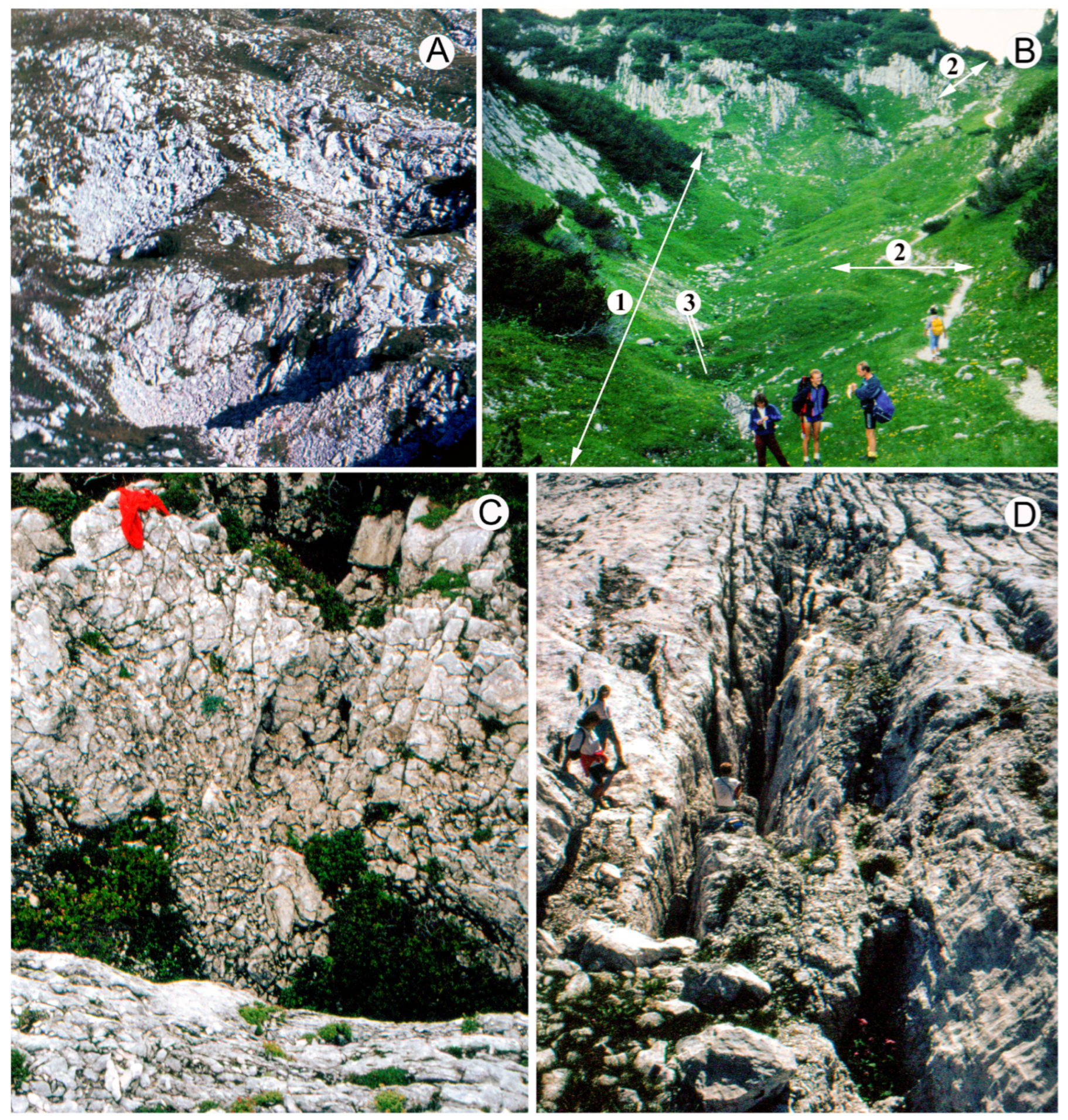
1.2. Karst Features of Glaciokarst
1.3. Dissolution on the Bare Surfaces of Glaciokarst
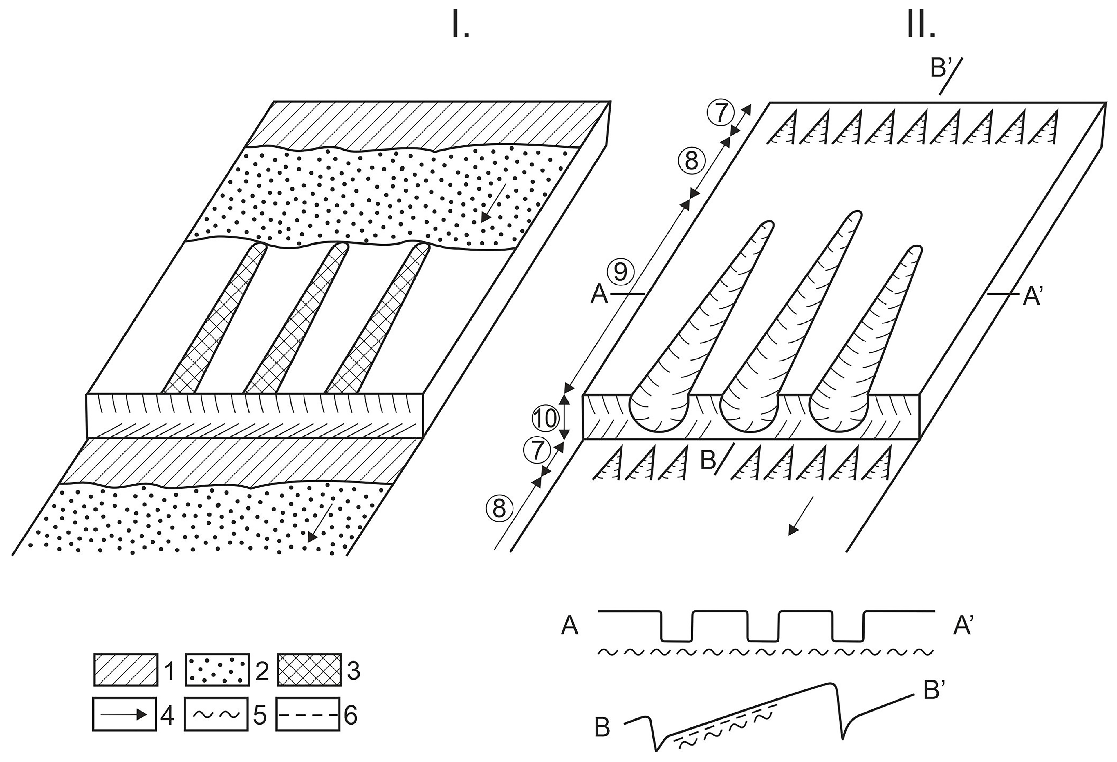
2. Methods
- -
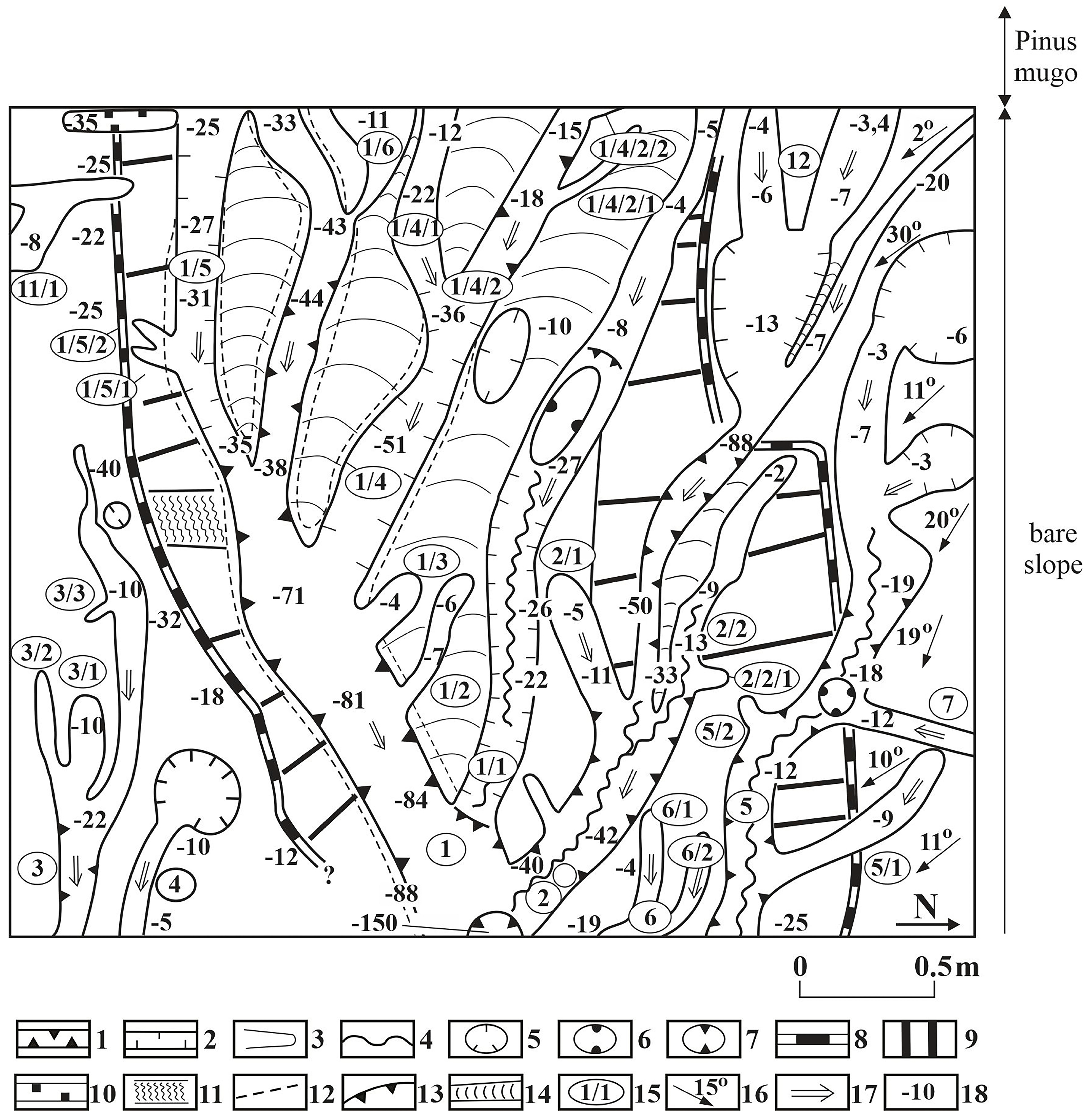
- Contour line maps of the studied area were made with theodolite.
- -
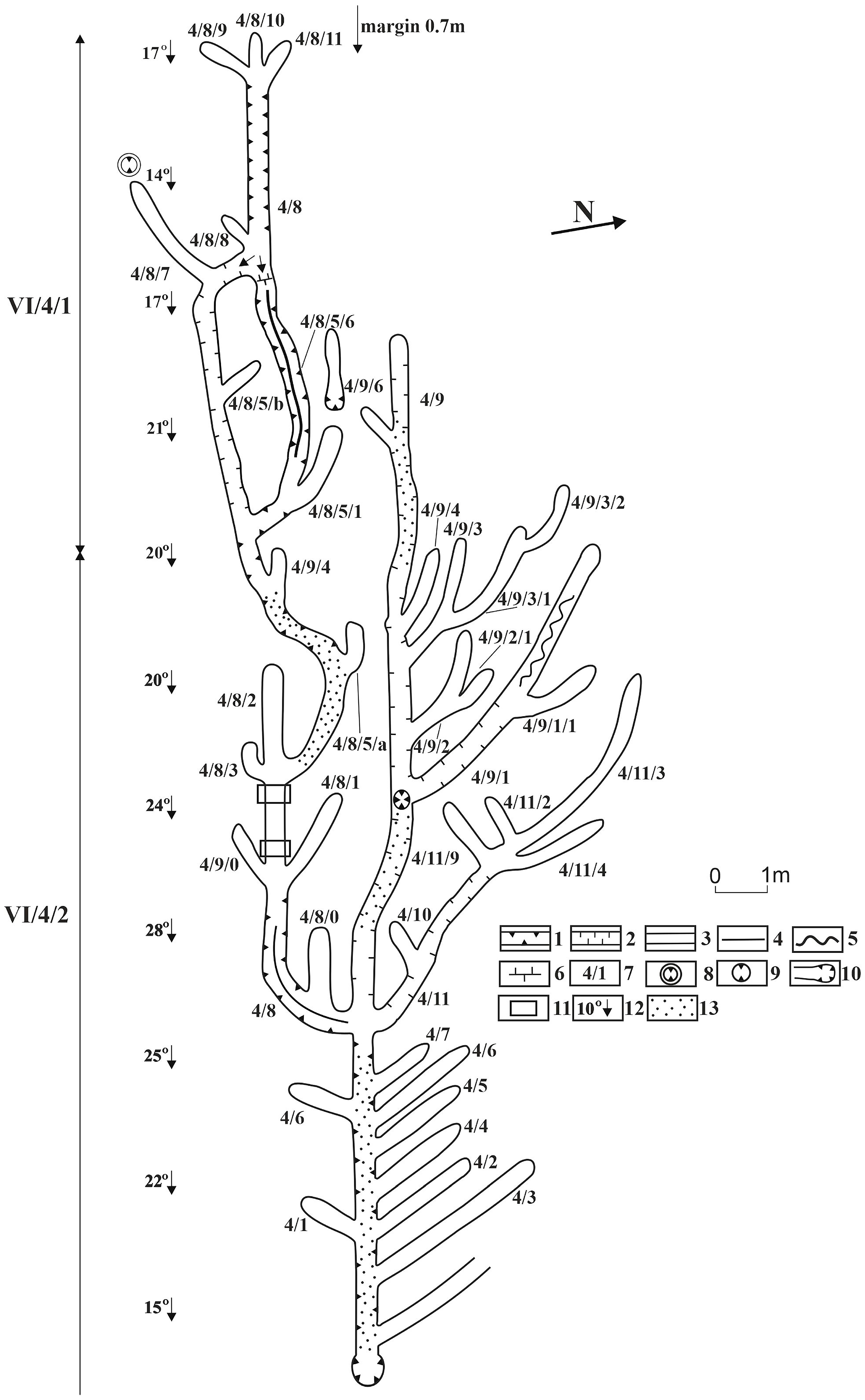
- A net was stretched (it was oriented and put into a horizontal position, the intervals of the net had an expansion of 50 × 50 cm) in the area to be measured. The opposite edges of karren features were fixed in the intervals and their sites were connected. At these sites, the depth of karren features, as well as inner, smaller karren features occurring in them was measured and marked on the maps. Sample sites marked 1/9XIX/1 and1/9/XIX/3 were mapped with this method.
- -
- In the case of a rinnenkarren system, the site of the edge of features, the width and depth of the features were measured along profiles being perpendicular to the main channel (the measurement sites were marked at a 1 m distance). (If there were smaller karren features in the channel, they were also measured), then the features were drawn by connecting the edges. The rinnenkarren system marked 4 was measured by this method.
3. Results
4. Discussion
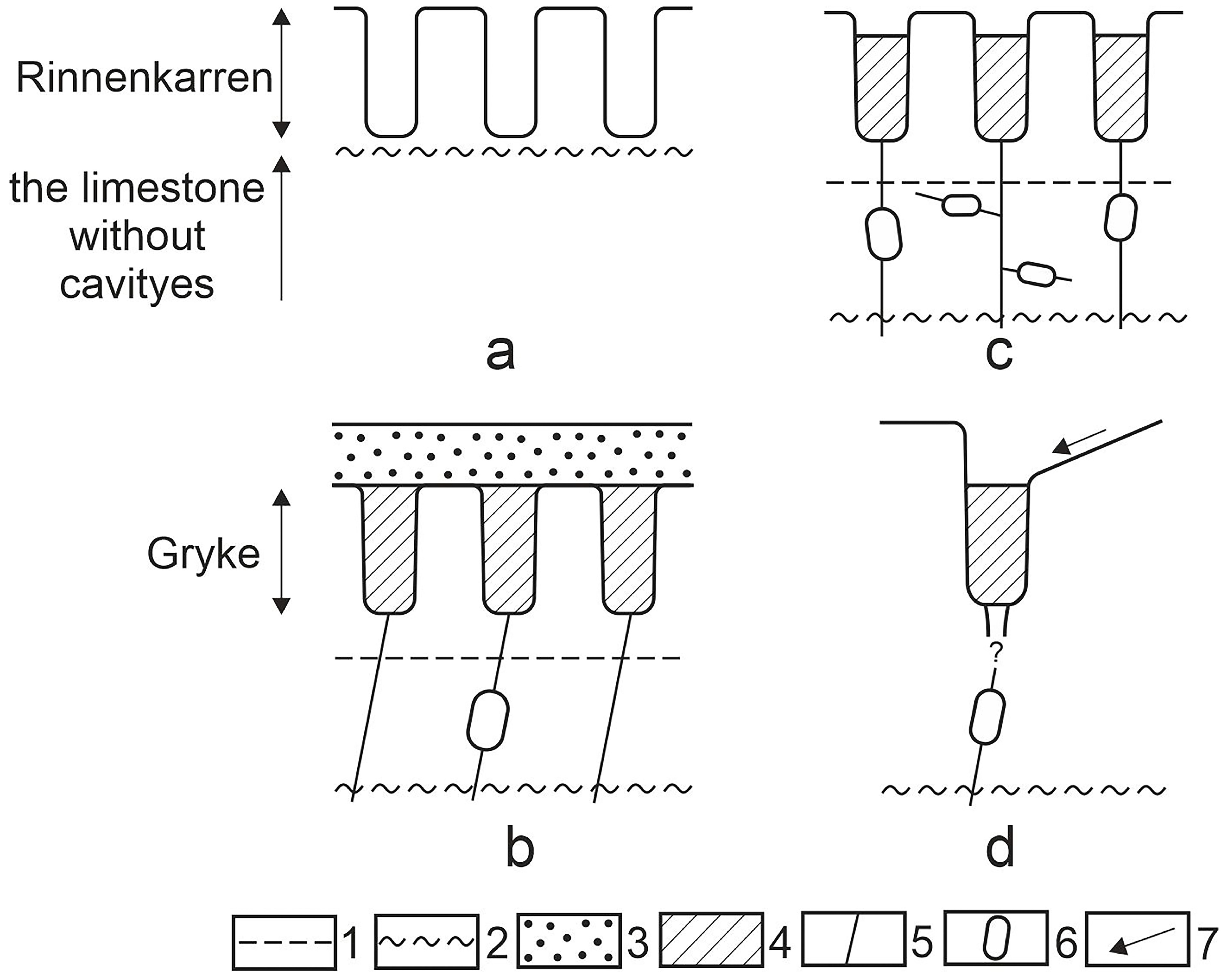
- -
- On the surface with bedding planes, if exclusively rinnenkarren is present, the water of the bedding plane flows down completely from the bedding plane. There is no cavity formation, and there is no water in the rock. This situation occurs at type A rinnenkarren where pits are absent.
- -
- On the surface with bedding planes, on the floor of rinnenkarren (if they are of type B and constitute channel systems), pits occur. The water of the bedding plane flows into the pits. A limited cavity formation may take place below the pits after soil formation. Local cavity formation (with water in the cavities) may develop in the environment of pits, but they became separated from each other.
- -
- Similar circumstances occur if the rinnenkarren of bedding planes terminate in pits. The water of rinnenkarren flows into these. Local cavity formation takes place in this case too, with water fill.
- -
- At larger patches of grikes there is no cavity formation, but water has a widespread presence below the patch in the rock.
- -
- At pit patch, there is cavity formation and water fill is possible in the rock below the karren, with piezometric level.
5. Conclusions
Funding
Institutional Review Board Statement
Informed Consent Statement
Data Availability Statement
Acknowledgments
Conflicts of Interest
References
- Sauro, U. Landforms of mountainous karst in the middle latitudes: Reflections, trends and research problems. Acta Carsologica 2013, 42, 5–16. [Google Scholar] [CrossRef]
- Mangin, A. Contribution A l’etude Hydrodynamique Des Aquiferes Karstiques. Ph.D. Thesis, Université de Toulouse, Toulouse, France, 1975. [Google Scholar]
- Bakalowicz, M. Epikarst. In Encyclopedia of Caves; White, W.B., Culver, D.C., Pipan, T., Eds.; Fitzroy Dearborn: New York, NY, USA; London, UK, 2019; pp. 394–398. [Google Scholar]
- Al-fares, W.; Bakalowicz, M.; Guerin, R.; Dukhan, M. Analysis of the karst aquifer structure of the Lamalou area (Herdult, France) with ground penetrating radar. J. Appl. Geophys. 2002, 51, 97–106. [Google Scholar] [CrossRef]
- Williams, P.W. Dolines. In Encyclopedia of Caves and Karst Science; Gunn, J., Ed.; Fitzroy Dearborn: New York, NY, USA; London, UK, 2004; pp. 304–310. [Google Scholar]
- Williams, P.W. The role of the epikarst in karst and cave hydrogeology: A review. Int. J. Speleol. 2008, 37, 1–10. [Google Scholar] [CrossRef]
- Jones, W.K. Physical Structure of the Epikarst. Acta Carsologica 2013, 42, 311–314. [Google Scholar] [CrossRef]
- Sweeting, M.M. Karst Landforms; Columbia University Press: New York, NY, USA, 1973; 362p. [Google Scholar]
- Jennings, J.N. Karst Geomorphology; Basil Blackwell: New York, NY, USA, 1985; 293p. [Google Scholar]
- Ford, D.C.; Williams, P.W. Karst Hydrogeology and Geomorphology; John Wiley and Sons, Ltd.: Chichester, UK, 2007; 562p. [Google Scholar]
- De Waele, J.; Gutiérrez, F. Karren and Sinkholes. In Karst Hydrogeology, Geomorphology and Caves; De Waele, J., Gutiérrez, F., Eds.; John Wiley and Sons Ltd.: Chichester, UK, 2022; pp. 336–465. [Google Scholar] [CrossRef]
- Alemdağ, H.; Köroğlu, E.; Aydin, Z.O.; Seren, A. Dicephering of karst geomorphology and dinkhole (doline) structures using multiple geophysical and geological methods (Trabzon, Türkiye). Bull. Engineening Geol. Environ. 2024, 83, 286. [Google Scholar] [CrossRef]
- Sauro, U. Closed Depressions in Karst Areas. In Encyclopedia of Caves; White, W.B., Culver, D.C., Eds.; Elsevier: Amsterdam, The Netherlands, 2012; pp. 140–155. [Google Scholar]
- Williams, P.W. The role of the subcutaneous zone in karst hydrology. J. Hydrol. 1983, 61, 45–67. [Google Scholar] [CrossRef]
- Kunaver, J. Geomorphology of the Kanin Mountains with special regard to the glaciokarst. Geogr. Zbornik 1983, XXII, 201–343. [Google Scholar]
- Veress, M.; Telbisz, T.; Tóth, G.; Lóczy, D.; Dmitry, R.A.; Jaroslav, G.M. Glaciokarsts; Springer: Cham, Switzerland, 2019; 516p. [Google Scholar] [CrossRef]
- Veress, M.; Deák, G.; Mitre, Z. The vertical electrical sounding (VES) of the epikarst: A case study of the covered karst of the Bakony region (Hungary). Acta Carsologica 2023, 52, 245–258. [Google Scholar]
- Veress, M. Solution doline development on glaciokarst in alpine and Dinaric areas. Earth-Sci. Rev. 2017, 173, 31–48. [Google Scholar] [CrossRef]
- Stepišnik, U.; Ferk, M.; Kodelja, B.; Medenjak, G.; Mihevc, A.; Natek, K.; Žebre, M. Glaciokarst of western Orjen, Montenegro. Cave Karst Sci. 2010, 36, 21–28. [Google Scholar]
- Hughes, P.D.; Woodward, J.C.; Gibbard, P.L.; Macklin, M.G.; Gilmour, M.A.; Smith, G.R. The glacial history of the Pindus Mountains, Greece. J. Geol. 2006, 114, 413–434. [Google Scholar] [CrossRef]
- Zebre, M.; Stepišnik, U. Glaciokarst landforms and processes of the southern Dinaric Alps. Earth Surf. Process. Landf. 2015, 40, 1493–1505. [Google Scholar] [CrossRef]
- Žebre, M.; Stepišnik, U. Glaciokarst geomorphology of the Northern Dinaric Alps: Snežnik (Slovenia) and Gorski Kotar (Croatia). J. Maps 2015, 12, 873–881. [Google Scholar] [CrossRef]
- Djurovic, P.; Petrovic, A.S.; Simic, S. The overall impact of Pleistocene glaciation on morphological diversity of uvalas at Durmitor and Žijovo. Serbian Geogr. Soc. 2010, 90, 17–34. [Google Scholar] [CrossRef]
- Veress, M. Karst Environments—Karren Formation in High Mountains; Springer: Dordrecht, The Netherlands; Berlin/Heidelberg, Germany; London, UK; New York, NY, USA, 2010; 230p. [Google Scholar]
- White, W.B. Geomorphology and Hydrology of Karst Terrains; Oxford University Press: New York, NY, USA; Oxford, UK, 1988; 464p. [Google Scholar]
- Trudgill, S.T. Limestone Geomorphology; Longman: New York, NY, USA, 1985; 196p. [Google Scholar]
- Bögli, A. Karrentische ein Beitrag zur Karstmorphologie. Z. Für Geomorphol. 1961, 5, 185–193. [Google Scholar]
- Sauro, U. Forme di corrosione su rocce montana-te nella Vál Lagarine meredionale. L’Universo 1973, 53, 309–344. [Google Scholar]
- Mazari, R.K. Himalayan karst-karren in Kasmir. Z. Für Geomorphol. 1988, 32, 163–178. [Google Scholar] [CrossRef]
- Jakucs, L. Morphogenetics of Karst Regions; Adam Hilgar: Bristol, UK, 1977; 284p. [Google Scholar]
- Bögli, A. Kalklösung und Karrenbildung. Z. Für Geomorphol. 1960, 2, 4–21. [Google Scholar]
- Czájlik, I. A Vass Imre-barlang részletes hidrológiai vizsgálatának újabb eredményei. (Newer results of the detailed hydrological investigation of the Vass Imre Cave). Karszt-és Barlangkutatás 1961, 3, 3–19. (In Hungarian) [Google Scholar]
- Gerstenhauer, A.; Pfeffer, K.H. Beiträge zur Frage der Lösungsfreudigkeit von Kalkgesteinen; Abhandlungen zur Karst- und Höhlenkunde, Reihe A Speläologie, Heft 2; Mangold: München, Germany, 1966. [Google Scholar]
- Dreybrodt, W. Processes in Karst Systems. Physics, Chemistry and Geology; Springer Series in Physical Environmental 4; Berling: New York, NY, USA, 1988; 288p. [Google Scholar]
- Bögli, A. Le Schichttreppenkarst. Un exemple de complexe glaciokarstique. Revue Belge de Geographie 1964, 1, 64–82. [Google Scholar]
- Veress, M. Morphology and Solution Relationships of three Karren Slopes in different Environments. Z. Für Geomorphol. 2012, 56, 47–62. [Google Scholar] [CrossRef]
- Telbisz, T.; Stergiou, C.L.; Mindszenty, A.; Chatzipetros, A. Karst features and related social processes in the region of the Vikos Gorge and Tymphi Mountain (Northern Pindos National Park, Greece). Acta Carsologica 2019, 48, 29–42. [Google Scholar] [CrossRef]
- Horton, R.E. Erosional development of streams and their drainage basins and their morphology. Bull. Geol. Soc. Am. 1945, 56, 275–370. [Google Scholar] [CrossRef]
- Glew, J.R.; Ford, D.C. Simulation study of the development of rillenkarren. Earth Surf. Process. 1980, 5, 25–36. [Google Scholar] [CrossRef]
- Mikhailenko, A.V.; Ruban, D.A. Epikarst ‘ruining’ Jurassic reefs in the Lagonaki Highland, Western Caucasus. Int. J. Earth Sci. (Geol. Rundsch.) 2020, 109, 2773–2774. [Google Scholar] [CrossRef]


| Profile Code | Bearing Terrain | Grike | Pit | Rinnenkarren | |||||
|---|---|---|---|---|---|---|---|---|---|
| Altitude | Slope Angle | Number of Karren Features | f.sz. [cm/m] | d. [Grike/m] | f.sz. [cm/m] | d. [Pit/m] | fsz. [cm/m] | d. [Rinnenkarren/m] | |
| T-1/1999 | 1859 | 31° | 27 | 4.93 | 0.64 | 5.0 | 0.29 | 15.64 | 1.0 |
| D-2/1999 | 1820 | 17° | 31 | 1.85 | 0.2 | 2.75 | 0.2 | 20.75 | 1.15 |
| D-3/1999 | 2051 | 21° | 35 | 4.44 | 0.4 | - | - | 15.85 | 0.77 |
| HIII-2/1999 | 2090 | 4° | 16 | 19.67 | 0.83 | 7.22 | 0.06 | - | - |
| HIII-1/1999 | 2098 | 8° | 20 | - | - | - | - | 14.90 | 0.97 |
| Slope Type | Rinnenkarren | Meanderkarren | Grike | Kamenitza | Trittkarren | Pipe | Area [m2] |
|---|---|---|---|---|---|---|---|
| Slope (part) fed from Pinus mugo patch | 19 | 1 | - | 3 | 1 | 1 | 4.96 |
| bare slope C1/9/XIX13 1 | 42 | 3 | 2 | 3 | 24 | 0 | 17.17 |
| bare slope (V) 1 | 44 | 1 | - | 1 | - | 2 | 66 |
| Mapped Area | Code of the Selected and Measured Rinnenkarren | Depth (cm) | Average of Depth [cm] |
|---|---|---|---|
| Slope (part) fed from Pinus Mugo patch (1/9/XIX/1) | 1 | 25(13.15), 27(52.61), 31(65.75), 71(137.56), 81(220.92), 84(255.11), 88(304.45) | 45.57 |
| 2 | 4(7.89), 6(31.50), 13(78.9), 88(118.35), 50(184.1), 35(210.4), 42(263.3), 40(254.50), 88(315.6) | 40.67 | |
| 5 1 | 6(0.0), 3(39.45), 7(78.9), 19(131.5), 18(170.95), 12(210.4), 25(270.89) | 12.85 | |
| bare C1/9/XIX/3 | 5 | 13(18.72), 106(78.00), 9(124.8), 286(202.8), 20(249.6) | 16 |
| 7 | 6(7), 15(18.72), 12(140.4), 27(171.6), 52(296.4), 42(343.2) | 25.67 |
Disclaimer/Publisher’s Note: The statements, opinions and data contained in all publications are solely those of the individual author(s) and contributor(s) and not of MDPI and/or the editor(s). MDPI and/or the editor(s) disclaim responsibility for any injury to people or property resulting from any ideas, methods, instructions or products referred to in the content. |
© 2024 by the author. Licensee MDPI, Basel, Switzerland. This article is an open access article distributed under the terms and conditions of the Creative Commons Attribution (CC BY) license (https://creativecommons.org/licenses/by/4.0/).
Share and Cite
Veress, M. Limitations of Drawdown Doline Development on Mountainous Glaciokarst. Glacies 2024, 1, 111-129. https://doi.org/10.3390/glacies1020008
Veress M. Limitations of Drawdown Doline Development on Mountainous Glaciokarst. Glacies. 2024; 1(2):111-129. https://doi.org/10.3390/glacies1020008
Chicago/Turabian StyleVeress, Márton. 2024. "Limitations of Drawdown Doline Development on Mountainous Glaciokarst" Glacies 1, no. 2: 111-129. https://doi.org/10.3390/glacies1020008
APA StyleVeress, M. (2024). Limitations of Drawdown Doline Development on Mountainous Glaciokarst. Glacies, 1(2), 111-129. https://doi.org/10.3390/glacies1020008