Need Help?
10 October 2020
Meet the Editors | Interview with Prof. Dr. Timo Balz—Associate Editor of Remote Sensing

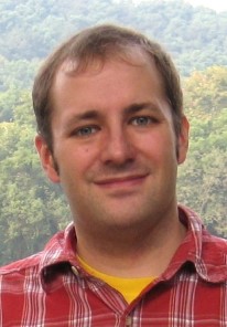
Prof. Dr. Ing. Timo Balz, from the State Key Laboratory of Information Engineering in Surveying, Mapping and Remote Sensing, Wuhan University, is the Associate Editor of the journal Remote Sensing. He is working on SAR interferometry and multi-temporal SAR data analysis. He has published over 150 papers. He is also the Associate Editor at the "Journal of Geodesy" and a member of the editorial board of "Geo-Spatial Information Science."
His research focuses on applying synthetic aperture radar data for measuring surface motion and surface-cover changes over time to better understand our dynamic Earth. Understanding today’s Earth dynamics also requires a better understanding of the past and therefore he is also working on using SAR remote sensing for landscape archaeology.
- What attracted you to do scientific editing for Remote Sensing?
Before I became an Associate Editor at Remote Sensing, I worked seven years as an Associate Editor for the IEEE GRSL. So, when your colleague asked me if I want to be an Associate Editor for Remote Sensing, I found it was a good time to change a bit. As an Editor, you will get a lot of input while reading and reviewing papers. One also learns more about the review process, which can be good for my own publications and also those of my students.
- Can you tell us a little bit about your current research?
I am mostly researching on radar, SAR remote sensing, focusing on dynamics; this includes surface motion from subsidence, landslides, etc., but also social dynamics in terms of the change detection and urban/human activities. In this context, I am also working on using SAR remote sensing to support archaeological prospecions and landscape analysis.
- Which research topics do you think will be of particular interest to the research community in the coming years?
For remote sensing, I would say in terms of remote sensing methods, the meaningful combinations of different sensors. When we look at applications, I would say we will be much more collaborative with researchers from other fields. Purely descriptive results are not enough and we will have to be analytical, i.e., answering the questions of ‘why’ instead of ‘what’. This will only be possible in collaboration with domain experts, so that we can fully use the power of remote sensing data. Moreover, with more data available, sometimes referred to as remote sensing big-data, our model-driven approaches are shifiting towards data-driven approaches.
- How do you think open access impacts authors/readers?
There is an interesting aspect to your question, as you put the author first. This is certainly one of the advantages of open access journals, like Remote Sensing, to have the authors’ interests in mind, supporting for example a fast review process, which is what my students especially like when publishing in Remote Sensing. Therefore, authors can get a wider readership and more citations.
For readers, there is a risk that there are too many publications and one can no longer find those that are of interest. Thus, we have to find ways by which we can guide readers to the right papers. I believe here we can learn from social media and their recommendations, but definetely should avoid creating scientific filter bubbles. It will not be easy, as we will have to find a middle way, between the readers and the authors interests, to best serve both.

