Article

Wargame Simulation Theory and Evaluation Method for Emergency Evacuation of Residents from Urban Waterlogging Disaster Area

1
School of Tourism and Geography Sciences, Jilin Normal University, Siping 136000, China
2
School of Environment, Northeast Normal University, Changchun 130117, China
*
Author to whom correspondence should be addressed.
Int. J. Environ. Res. Public Health 2016, 13(12), 1260; https://doi.org/10.3390/ijerph13121260
Submission received: 28 November 2016 / Revised: 28 November 2016 / Accepted: 1 December 2016 / Published: 21 December 2016

Abstract

:
Urban waterlogging seriously threatens the safety of urban residents and properties. Wargame simulation research on resident emergency evacuation from waterlogged areas can determine the effectiveness of emergency response plans for high risk events at low cost. Based on wargame theory and emergency evacuation plans, we used a wargame exercise method, incorporating qualitative and quantitative aspects, to build an urban waterlogging disaster emergency shelter using a wargame exercise and evaluation model. The simulation was empirically tested in Daoli District of Harbin. The results showed that the wargame simulation scored 96.40 points, evaluated as good. From the simulation results, wargame simulation of urban waterlogging emergency procedures for disaster response can improve the flexibility and capacity for command, management and decision-making in emergency management departments.

1. Introduction

Disaster relief operations, like war, as the basis of wargame simulations have gradually been applied to disaster rescue and management in Incident Management Systems (IMS) [1,2]. We can look for the “optimal” result through “gaming”, in both a cost- and time-effective manner. Wargame theories are used mainly in negotiations for competitive, confrontational affairs [3,4]. The US Federal Emergency Management Agency (FEMA) has applied wargame theories in the disaster management of important development projects [5]. The Environmental Policy Institute of Taiwan developed a scenario wargames system attuned to local conditions. However, there has been limited research on the evacuation of residents from an urban waterlogged disaster area. Previous studies were mainly focused on urban waterlogging emergency management, building wargame models and establishing an evaluation system or procession rules based on the time standard [6]. The basic method of wargames is to use the board as the city disaster space, phases as the disaster evolution time, game pieces as the state of the disaster and power disposal, and dices (random number) to represent the uncertainty and complexity of disaster and management of the response. According to the scenario setting, the fight against the disaster is simulated by moves. The continuous dynamic process of urban disaster situations and management activities is simulated adhere to certain rules. Referring to game theory, probability theory, statistics and other scientific methods, a wargame could numerically simulate various disasters and human behavior. This result could reflect possible human responses and the initiation and development of disasters in a crisis environment [7,8]. Emergency drills are also conducted [9,10]. Conversely, a wargame can test the emergency plans, identifying vulnerabilities in them. Additionally, it could support decision-making and command personnel, and improve the management of an urban disaster emergency at a low cost [11,12]. Hence, for the current study, a wargame simulation was carried out under various scenarios settings of waterlogging disasters, and government agencies that participate in the waterlogging evacuation could be seen as a player. The disaster was the opponent. Our study aims at improving the capacity of command, management and decision-making of emergency departments through training.
There are four basic terms for wargame simulation of urban waterlogging disaster evacuation: waterlogging, waterlogging disaster, emergency evacuation and wargame. Currently, certain differences exist in the definition of these terms. Especially, the concept of wargame is interpreted very differently among scholars. Therefore, it is necessary to define these terms here in order to describe the subsequent study.
Urban waterlogging refers to standing waters and excessive runoffs due to short, heavy rainfalls or extensive precipitation in low-lying areas with poor drainage [13]. Urban waterlogging can be caused by the following factors: First, local rainfall increases due to the urbanization process and air pollution [14,15]; Second, the greatly reduced drainage capacity due to lagged construction of drainage networks during the process of urbanization [16,17,18]; Third, urban surface changes brought about by the reduced permeability of the underlying surface, less ground roughness and greatly shortened water convergence time—during heavy rainfall, storm water cannot be discharged promptly. Fourth, urban management, new urban drainage network planning, management, daily drainage network dredging, old town drainage network remodeling, drainage network daily quality assessment and city natural water bodies protection and management are key measures for maintaining the normal function of urban drainage systems [19,20].
Waterlogging and waterlogging disasters are concepts often creating confussion. Waterlogging disasters occur after urban waterlogging, resulting in post-waterlogging losses in terms of urban infrastructure, property and safety of residents. If waterlogging causes no loss, it will not be deemed a disaster. Thus, waterlogging disasters mean that, within the city limits, due to abrupt heavy rain or continuous rainfall, water is accumulated on a large-scale on urban roads, resulting in an urban water disaster [21]. Urban waterlogging disasters can be caused by either natural or human factors such as the city effect. A waterlogging disaster has the attributes of suddenness and uncertainty, but also has predictability due to their periodic (mostly in summer) occurrence. With the acceleration of urbanization, the frequency of waterlogging disasters is proportional to the magnitude of urbanization. Urban waterlogging disasters may result from natural, human and topographical factors.
The concept of evacuation has long existed. Evacuation is necessary to avoid disaster or destruction. Due to earthquakes, tsunamis, storms and other natural disasters, abnormal behavior or negligence, wars, or accidents, residents move from their original place of residence for their personal safety and that of their property. Early in the piece, evacuation is relatively simple, basically fleeing. Such evacuation has no guaranty of safety for life, although there is a general direction. Since such evacuations cannot guarantee life and safety, the situation can be very dangerous. With the improvement in the theory and methods surrounding emergency planning, government agencies concerned with construction, management and emergency services have also been involved in evacuation operations in addition to taking disaster prevention and mitigation measures. As a result, the safety of evacuees can be ensured and necessary supplies can be provided for the duration of the emergency evacuation process [22,23].
Wargame research was first developed abroad. In the early 18th century, a court civilian war adviser, von Rice Horowitz, invented the wargame, which used a map, pieces, rules, dices and a probability table to simulate the process of military engagement. A wargame was used to deduce the actual process of wars. A wargame has been defined in many different ways. In a broad sense wargame refers to combat simulation, including wargame procession, table-top exercises, military exercises, combat simulation and analytical modeling. In a narrow sense, wargame refers only to a computer or manual actions [24]. A wargame consists of four basic elements: the game board (map), pieces, rules and a scenario. The game board is a wargame map drawn with a specific scale from an actual map (landscape), or a special military topographic map. No matter what maps are used, players must always be aware of the current location, terrain, and the next moves of their own troops. In order to achieve this process, generally, a grid is placed on the map, and wargame pieces are much like pieces of board games, but the wargame pieces each representing a unit operator or annotation operator, usually labeled with the corresponding properties, such as the country they belong to, mobility value, the unit type, the unit name, the offense and defense capacity and other important information. Wargame rules are the ways by which pieces can be moved or activities can be exercised on the game board by the players, like the example for moving pieces on a chess board [25]. Because of uncertainty and contingency in the deduction process, most wargame deduction processes require the use of dices to rule for the final outcome of a battle, and award once each round, forming a war situation. The wargame is deduced step by step until the end of the whole process, achieving the objective of exercising the command ability. The wargame scenario, also known as script, is a detailed description of the operational environment and situation. A wargame scenario can also be understood as a simple wargame story in a particular context, thus a successful wargame scenario is the key for the wargame deduction to succeed [26].

2. Materials and Methods

2.1. Wargame Theories for Emergency Evacuation

Emergency evacuation wargames must be based on the full knowledge of emergency evacuation procedures, build the game model of confrontation between human and the disaster using wargame method as the principle, and simulate “reasonably evacuated” or “evacuation failed” [27]. Under the concept of “evacuation operations as wars”, a wargame is introduced into urban waterlogging disaster emergency evacuation process. The process of resident emergency evacuation can be divided into several sub-processes. In the deduction of a wargame, one can use decision trees, Action-Reaction-Counteraction loops and other methods. The deduction may be casted branch by branch until the entire tree is finished. In each branch, the player must promptly integrate all enemy selections for a given situation, form one’s own actions, and respond. One’s own action may likely lead to more enemy actions. This is repeated to form a collection of confrontations. The process is repeated until the end of a critical phase or the defeat of one party. After the deduction, the results and the processes are evaluated, so that advantages and disadvantages are understood, and the best solution for subsequent deduction is provided for the next time.

2.2. Wargame Principles for Waterlogging Disaster Evacuation

The basic method of a wargame is using the board to represent the space, phases, disaster evolution, using pieces to represent disaster status, force disposal of “the enemy” and one’s own side. The pieces reflect key elements of the deduction process [28,29]. In accordance with the rules, a dice is used to generate uncertainty and complexity of waterlogging disaster status and force disposal. Based on the scenario, pieces are moved to represent the confrontation with the waterlogging condition. Through ruling, a continuous, dynamic waterlogging disaster situation is formed, reflecting the real disposal process combating a waterlogging disaster. One can use the game theory, probability theory, statistics and other scientific methods. By numerical simulation modeling of waterlogging disasters and human behavior, the development of waterlogging disasters and human responses are played out on a virtual platform. The disaster and human response can be maximally reflected in the process of simulation. As such, high risk and high value disasters are evaluated at low cost. A wargame simulation may reveal defects in emergency plans, train decision-making and command personnel, improving the management level of urban waterlogging disaster situations [30].

2.3. Contents and Procedure of Wargame for Urban Waterlogging and Evacuation

Comprehensive plans must be made for a wargame simulating emergency evacuation of residents threatened by urban waterlogging disasters. The game designer needs to bear in mind wargame theories, disaster theories, and emergency evacuation theories. It is necessary to include the direct cause of the disaster, and also consider the status of disaster bearing body. Based on the above theories, a wargame flow is built for urban waterlogging disaster emergency evacuation. The deduction process is divided into five general phases, namely the preparatory phase, the search and rescue phase, the reinforcing and repair phase, the placement phase and the management phase (Figure 1).

2.4. Rules and Evaluation Methods for Wargames Used for Evacuation of Residents Affected by Urban Waterlogging Disaster

2.4.1. Deduction Rules

Wargame rules govern the movement of each piece, the outcome of the battle and the wargame. The rules must be set according to the actual property of pieces and battlefield. Military wargame rules need to be set according to realistic military force, weapon systems, equipment systems, mobility and defense force [31]. This study focused on the “game” between various emergency response units and waterlogging incidences. The rules were extracted from the long time disaster management experiences and daily exercises of local emergency departments. The rules defined the guidelines in mobilizing emergency services, relief supplies transport, traffic control, resident evacuation and confrontation ruling, including ruling methods for disaster losses in terms of lives, property, buildings, roads and other infrastructure. Scores were awarded primarily based on the ability of emergency rescue capabilities of the emergency departments and the extent of relief in the road waterlogged regions [32,33]. When residents meet waterlogging conditions, a ruling is made according to the attribute relationship between the resident piece and the waterlogging disaster piece, for example, evacuation of a resident must be deemed as a success or failure based on the water depth.
First, the responsibilities were defined for various emergency departments during the wargame of an urban waterlogging disaster emergency. Second, phases were set based on real conditions. Specifically, there was a starting phase, ending phase, sustaining phase and expectation phase. The starting phase was when all the emergency departments started to initiate the emergency process. The ending phase was when all the emergency departments were executing an emergency ending procedure. The expectation phase was the expected number of emergency procedures performed. The sustaining phase was the actual number of emergency procedures performed by each emergency department. In order to ensure the reasonableness of the study and evaluation, these phases were set in accordance with field investigation results and “The Harbin flood emergency plan”, “the People’s Republic of China Flood Control Ordinance” and “Emergency Response Law of the People’s Republic of China”, which is shown in Table 1.

2.4.2. Evaluation Method

The evaluation of the wargame deduction results could expose vulnerabilities and weaknesses in the emergency plans for various departments. Consequently, amendments are proposed in a timely manner to make emergency plans more reasonable. The evaluation of the emergency evacuation included qualitative and quantitative indicators. These indicators are introduced below respectively.
(1) Qualitative indicators
In a wargame simulated evacuation of an urban waterlogging disaster, qualitative indicators are used to reflect the quality of the emergency response capacity, which is often obtained directly based on the experience or intuitive judgments of emergency management personnel [34], commonly indicated by “yes” or “no”. In order to quantify the qualitative properties, in this study, “ordered” and “not ordered” were scored 1 point and 0 points, respectively.
(2) Quantitative indicators
In the evaluation of a wargame, quantitative indicators are used to reflect the quantitative property of the emergency response capacity. Quantitative indicators can be directly shown as numerical values. In this study, these indicators include the starting phase t1, the ending phase t2, the expecting phase t3 and the sustaining phase h. Since each emergency response unit used a different value for a phase, and orders were given at a different time, therefore, the score for each unit was calculated using a fixed value F for every emergency department. If an order was given too late, it could lead to a large value for the sustaining phase for an emergency response unit to carry out its mandate, thus the score could be biased. During the calculation of the score S for an emergency unit, when h < F, Equation (1) was used; otherwise, Equation (2) was used. This study set F = 8.
When h < F:
S = { h ( t 1 t 3 ) h 0 , h t 1 t 3 , h < t 1 t 3
When h > F:
S = { h ( t 1 t 3 ) h , t 1 t 3 < F 0 , t 1 t 3 F
where S stands for each emergency scores, h is time, t represents round, F represents the fixed value of the round test.

2.5. Developing Approaches for the Regulation of Wargame

2.5.1. Rainstorm Regulation

Rainstorm regulation, as the average intensity of the heavy rains in a closed looped, could be applied to the hyetograph model. Because the rainstorm regulation is related to the historical data of rainfall with different average intensities, Chicago hyetograph model (CHM) is suitable for the rainstorm hyetograph in China. The calculation process is as follows:
  • According to the formula (CHM), the total precipitation in t time was calculated:
    H = i ¯ t = a t ( t + b ) n
    where i ¯ is the average precipitation intensity in t time. a, b and c are constants.
  • Instantaneous precipitation intensity in t moment is deduced from differentiation of H.
    i t = d H d t = a [ ( 1 n ) t + b ] ( t + b ) n + 1
  • r, the peak value ranges from 0.3 to 0.5 of precipitation intensity, is the actual rainfall events. The t is calculated as follows:
    t = t a r = t b 1 r
    where t b is the duration of rainfall before the peak value, the same as t a after the peak value.
  • Formula (5) is added to Formula (4):
    i b = a [ ( 1 n ) t b r + b ] [ ( t b r ) + b ] n + 1
    i a = a [ ( 1 n ) t a r + b ] [ ( t a r ) + b ] n + 1
  • Referring to the rainstorm intensity formula:
    q = 2889 ( 1 + 0.9 l g P ) ( t + 10 ) 0.88
    where p is the return period (as shown in Table 2), t is the duration of rainfall whose unit is hand q is the rainstorm intensity with the unit L/(S·hm2), respectively.

2.5.2. The Simulation Method of the Wargame

a. Mapping the wargame
Patch Grid Plugin is used and introduced to the Arcgis10.2 software (Redlands, CA, USA) in this system, which could be helpful to map the regular hexagon. Before the final wargame map, underlying surface information needs to be related to the wargame map by the attribute relationship in the Arcgis10.2.
b. The decision process of road waterlogging
First, we need to determine the precipitation intensity, and build the precipitation intensity decision table based on the rounds of precipitation. Hypothetic deduction time about rainstorm intensity is 5 years, and there are 18 rounds from beginning to the end. The precipitation intensity P could be get from the 18 rounds in the decision table.
Secondly, calculating the loss, e.g., initial losses (interception and depression storage), infiltration losses, the rounds of runoff, displacement in drainage network, as the losses. When the loss is zero, it indicates the road waterlogging is discharged.
The calculation of initial losses. According to the Horton formula and Horton intercept formula, the initial losses are calculated as the formula:
J = a + bpn
where, J represents the amount of rainfall interception; p is rainfall; a, b, n is the parameters.
The calculation of infiltration losses. Due to the runoff coefficient of beton and the pitch, which is 0.9, the infiltration losses are calculated by the following formula:
R = 0.9 × P
where, R is the infiltration rate within the grid; P is the rainfall; surface infiltration parameters are generally set to 0.9.
The calculation of rounds of runoff. According to the rounds of runoff, the precipitation intensity PD in the round was calculated. P1, represents the precipitation intensity from the first round to the current round. P2, represents the precipitation intensity from the first round to the prior of current round. The comparative analysis is conducted between P1, P2 and initial losses J. When P1 < J, it shows the precipitation experiences initial losses and no runoff appears; P2 < J < P1, there is no runoff in current round, and runoff appears in the middle round with the precipitation intensity PD = (PJ) × 0.9; P2 > J and P1 > J, the precipitation intensity in the current round is calculated as follows:
PD = P × 0.9
where PD is the rainfall in each grid; P is the rainfall.
The calculation of displacement in drainage network. According to the rainfall characteristics and actual network programme in Harbin City, this research defines the precipitation return period of the underground network as 1, which means T = 1. Hence, the specific flow of the drainage network is calculated as follows:
q m a x = i F
where q m a x is the flow; i is the precipitation intensity when the return period is 1; F is the area of the hexagonal grid S; is the runoff coefficient.
Thirdly, calculating the flows and depth of detention seeper and refer to many formulas as following:
Uniform flow velocity formulas in Open-channel flow:
v = 1 n × R 2 3 × i 1 2
where R is the hydraulic radius; n is the roughness coefficient; i is the hydraulic slope.
The formula of hydraulic radius R:
R = W × H W × 2 H
where W and H are the width and depth of flows, respectively.
The formula of hydraulic slope i:
i = | h 1 h 2 | d
where | h 1 h 2 | and d are absolute elevation value and distance between the adjacent hexagonal grids, respectively.
The formula of the flow in each round:
V= v × t × 6
where V is the flow; v is the flow speed, t is the time in each round with the unit is min.
The formula of depth of detention seeper
h = V S
where h is the depth of detention seeper in hexagonal grid; V is the water accumulation in hexagonal grid, and V = PDJRqmax. S is the area of hexagonal grid.
c. The regulation of moving piece
Referring to the “The Art of war 3” from Talonsoft Company (Baltimore, MD, USA) and considering the actual environment in the study region, we designed a hexagonal grid to represent the 260 m distance. When a piece moves a hexagonal grid, it means a piece has moved 260 m. Based on the speed and distance, it could calculate the distance in each round and get the decision processes of different vehicles (Table 3).
d. The drainage of waterlogged areas
Pumping water is the most effective method to address road waterlogging, and the effective and timely drainage of water is the important standard by which to measure urban rescue capabilities. The drainage system contains a pumping station and temporary pumping station with drain waterlogging of 5.5 m3/s. Likewise, the drainage system could deploy moving pumping car, emergency pumping, motor-generator, etc. to speed up the emergency response. Combined with the decision in Section 2, the drain waterlogging capabilities are calculated, time and rounds. Hence, the depth of drain waterlogging is defined for real-time computing by the difference values between the drainage waterlogging and the results from Section 2. Each round could be calculated until the waterlogged area is drained. With rainstorm simulation in the 5-year return period, it could be determined that the road waterlogged area will be completely drained by the eighteenth round.

3. Results

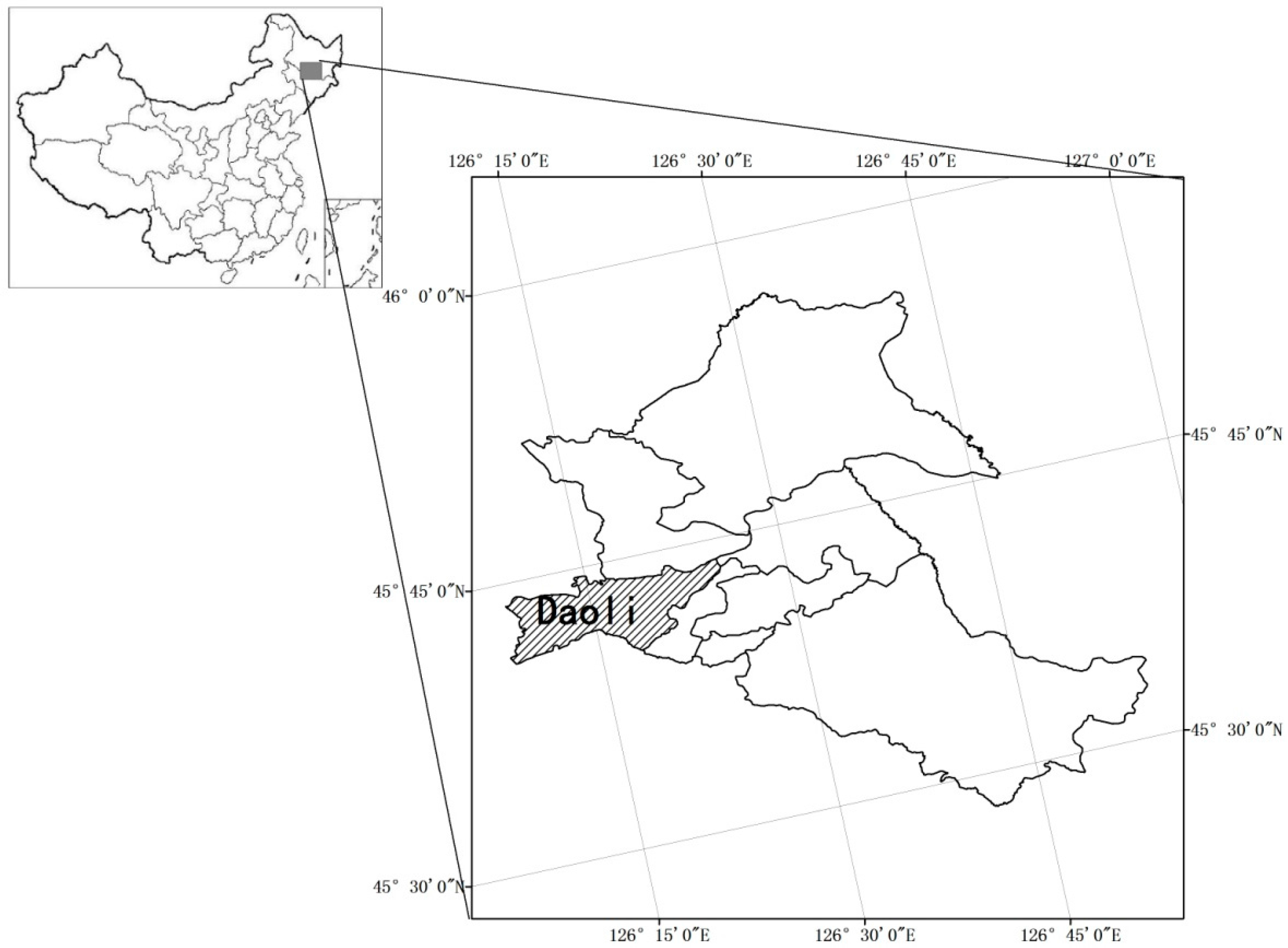
Ha-Erbin is the capital city of HeiLongjiang province in China, and it is located at 125°42′–130°10′ east longitude and 44°04′–46°40′ north latitude (Figure 2). The city is the center of politics, economy, culture and transportation in Northeastern China, it has the largest metropolitan area in the region and is also the second largest provincial capital city in terms of expanse and population and one of the top 10 largest cities in China. The city has an area of over 53.1 thousand square km, consisting of eight districts and 10 counties (suburbs). The total population is 10.635 million people, and downtown residents are over 5.879 million people. The average annual rainfall precipitation is 569.1 mm, summer is hot and humid with frequent rains. Major precipitation occurs in June–August, which receives over 60%–70% of total annual rainfall. Because of the rainfall seasonality, rainstorms occur periodically during the summer.
During a waterlogging emergency, the resident emergency evacuation process includes the resident evacuation process and the assisting process by government departments. The former includes: receiving waterlogging disaster warning → warning announcement → residents receiving alerts → preparing for evacuation → start evacuation → reach temporary resettlement sites. The latter includes: waterlogging disaster forecasting → warning announcement → emergency orders → emergency services arriving at designated locations → traffic control → search and rescue → assist resident evacuation → reach settlements [34,35]. When a waterlogging disaster occurrs, in addition to assisting residents in evacuation, it is necessary to mobilize the Armed Police Department, the Police Department, emergency departments, medical departments, supplies department and victim placement management departments to work together to safely complete the resident evacuation [36,37]. Based on the above analysis and the five basic phases, the government emergency units can be divided into nine deduction seats, in accordance with their respective responsibilities and chain of command, and aligned with the five basic deduction phases.

3.1. Preparation Phase Simulation

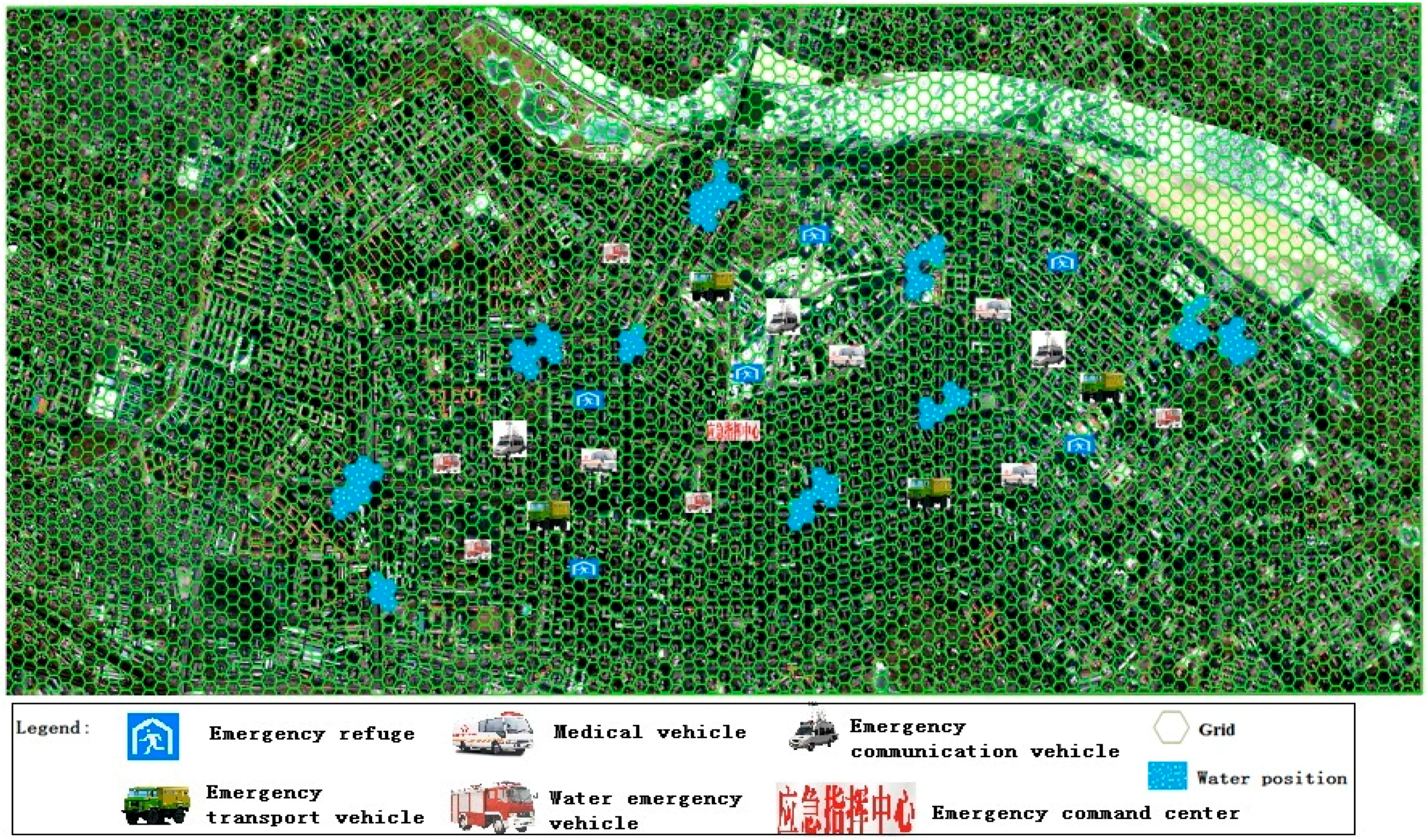
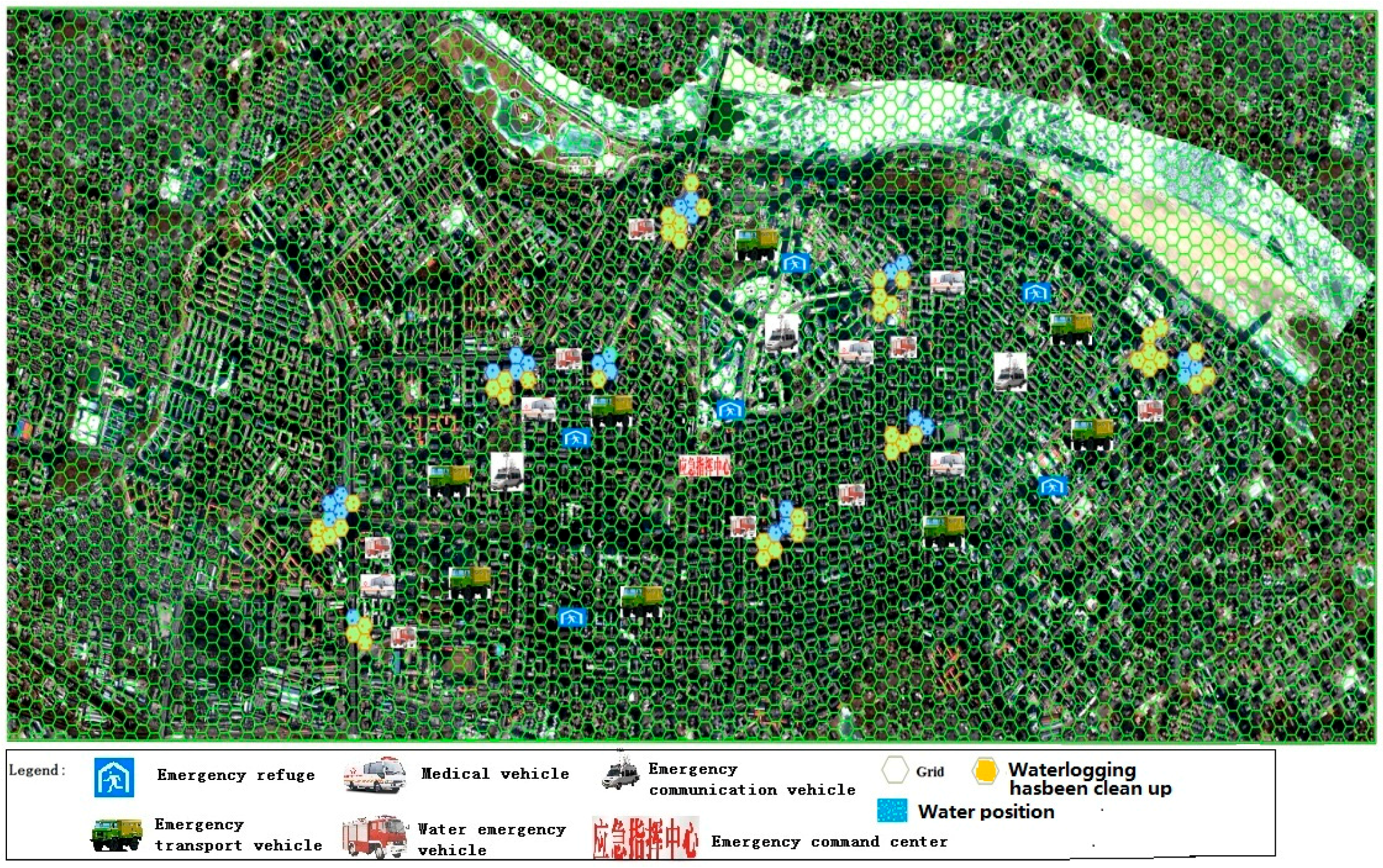
This phase simulated activities before rain. According to cloud map data, the meteorological department forecasted severe convective weather within the next six hours, and more than 100 mm of rainfall. At this point, a red rainstorm warning was issued, and the warning was sent to the municipal government. The municipal government immediately began to set up an emergency command center, and ordered emergency units to be ready for the emergency response and mitigation efforts. Subsequently, these units initiated the urban waterlogging disaster emergency plan. The numbers of rounds in the starting phase, ending phase, sustaining phase and expecting phase for emergency units involved was set according to the provisions of the emergency plan. The scores for an emergency unit after the deduction were calculated based on either the above Formula (1) or Formula (2). The qualitative indicators were scored according to the above qualitative indicator assignment methods (as show in Table 4). On 10 August 2011, the City of Harbin was hit by heavy rain, which lasted about 12 h, and local rainfall exceeded 100 mm. The evacuation process was simulated based on such an example (Figure 3).

3.2. Search and Rescue Phase Simulation

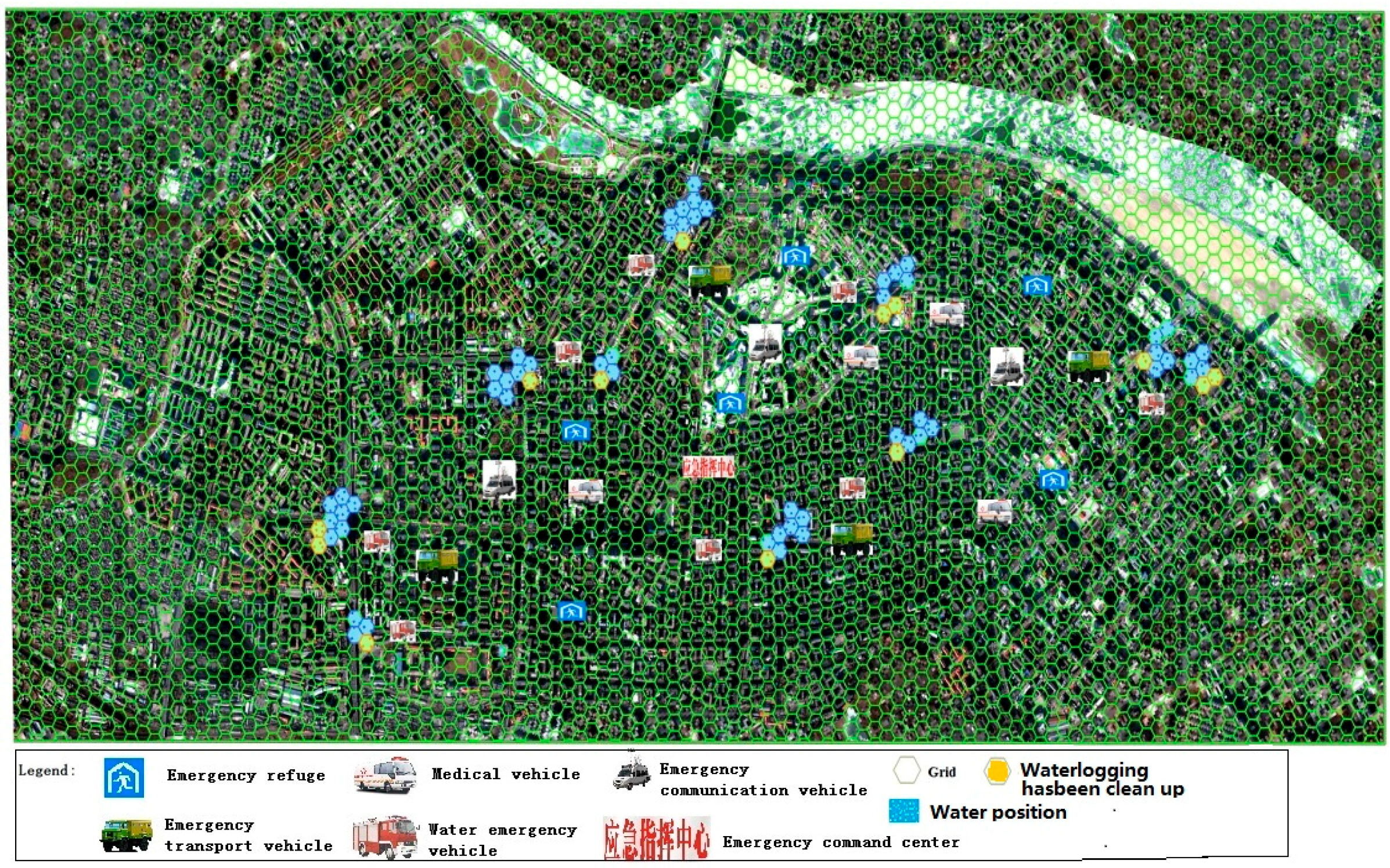
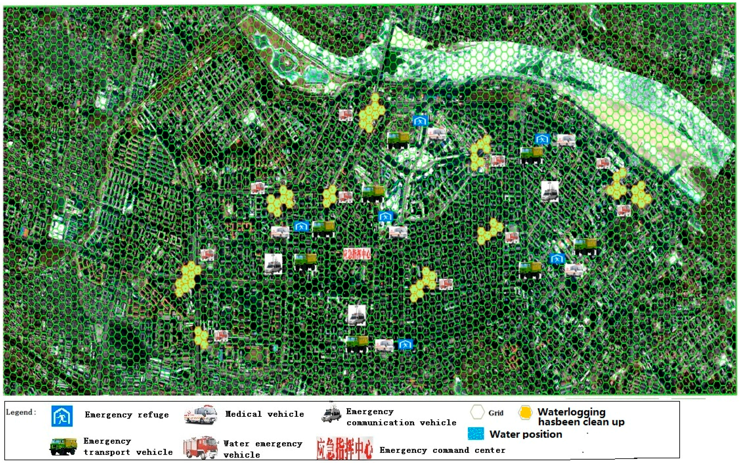
When the city waterlogging disaster occurred, the emergency command center began searching, rescuing, and organizing resident evacuations. Police officers arrived at the low-lying areas, controlled road traffic, evacuated victims, counted the number of people, and reported findings to the emergency command center. The ruling group set the location and the number of missing individuals. The armed police department was responsible for search and rescue. The city health department dispatched ambulances and medical personnel to carry out the rescue, including wound treatment and patient transfer. The Hydrology Bureau and the Municipal Water Conservancy Bureau jointly conducted measurement and monitoring of water on roads, and the results were presented to the emergency command center. Experts recommended rescue plans and a scoring framework according to the real measures, proposed reasonable allocations of emergency personnel and supplies. The municipal electric power department received orders from the emergency command center to start emergency power plans to ensure normal power supply to residents. The armed police, public security bureau, and health bureau were responsible for counting the number of casualties, reporting the statistics agreed upon to the emergency command center, the municipal communist party committee propaganda department made the current emergency relief work and future plans public. According to commands from the emergency command center, the city transport sector transported emergency supplies and rescue equipment to several destinations. The specific deduction process is shown in Table 5, and the score for each deduction command has been calculated (Figure 4).

3.3. Reinforcing Repair Phase Simulation

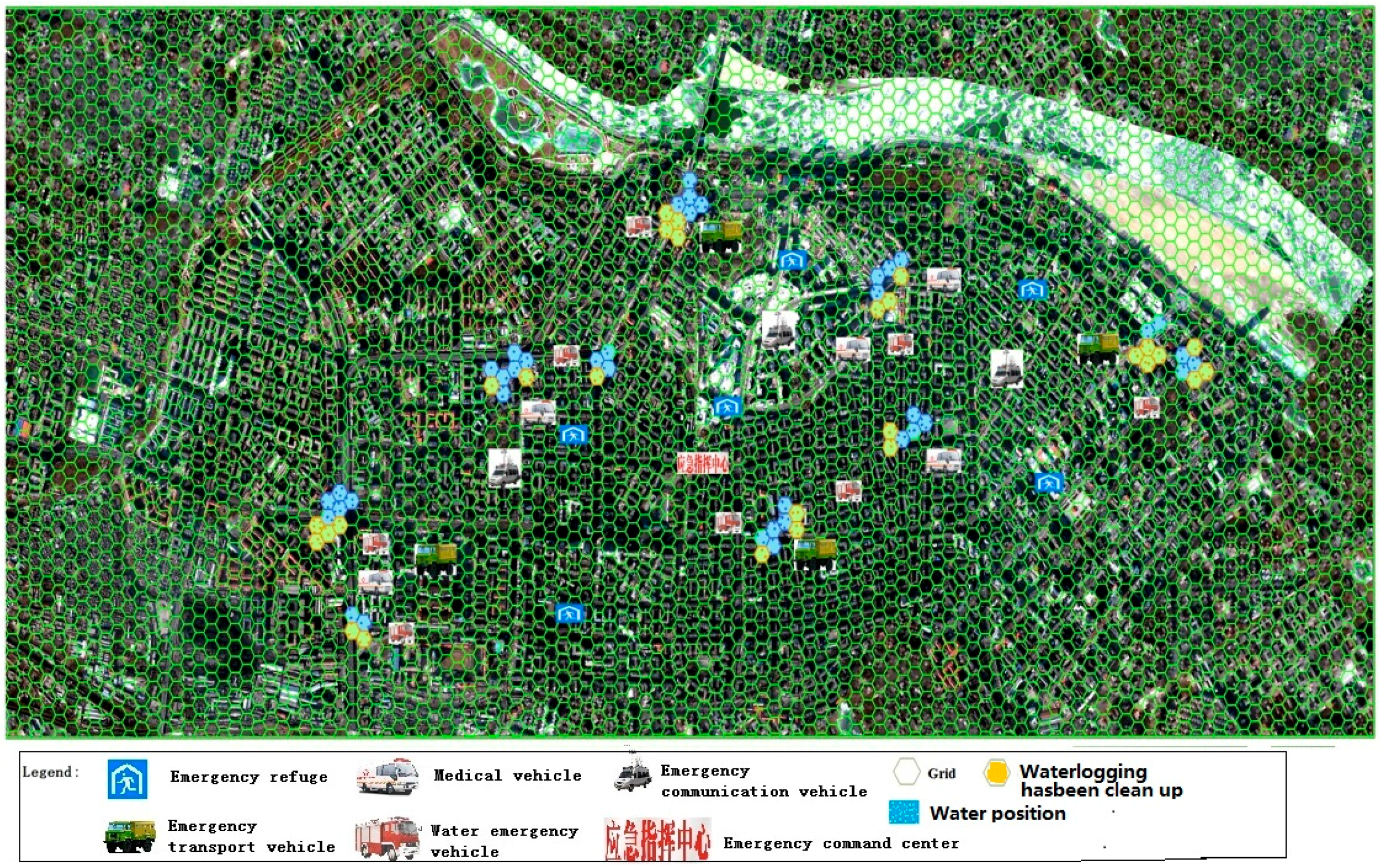
Upon the occurrence of a waterlogging disaster, the emergency command center and the ruling group need to issue reinforcement rescue commands. While rescue departments need to carry out rescue missions, they also have to repair and reinforce rescue equipment, roads and infrastructure, so that secondary damage can be avoided. At this phase, the simulation mainly tests the ability of emergency departments in responding to sudden storm events. The emergency command center continues to monitor waterlogged roads, dam stability and power grid damage to ensure timely repair and reinforcement. The ruling group determines the most appropriate response, based on the nature and location of storm events. In this study, the deduction process was conducted only once. For example, only one incidence of power or communications interruption was incorporated to examine emergency rescue ability in regards to communications or power grid failure. The Meteorological Bureau was charged with monitoring the main road water status and failed sites. Once a fault was detected, mobile monitoring vehicles were sent immediately to the point of failure. The city information commission was responsible for maintaining communication during the emergency rescue, coordinating carriers to dispatch repair vehicles to the point of failure in order to restore the communication network (Figure 5). The emergency command center detected a point of failure, promptly issued emergency orders, and organized emergency units for troubleshooting and reinforcement. The municipal propaganda department broadcasted the current status through television, internet and other means of media. The scores at this phase are shown in Table 6.

3.4. Placement Phase Simulation

The Placement phase simulated the process in which the emergency command center sends out orders to assist in the evacuation; the Civil Affairs Bureau selected temporary accommodation sites, assisting the Department of Transportation in the delivery of emergency supplies and helping transport victims reach temporary accommodation sites (Figure 6). The Civil Affairs Bureau, the Health Bureau and the Public Security Bureau counted the number of casualties, and reported findings to the emergency command center, waiting for the next command. The specific scoring scheme is shown in Table 7.

3.5. Management Phase Simulation

The management phase involves the emergency command center, the sewerage corporation, the Urban Management Bureau, the Health Bureau, the placement center, the Housing Security Administration and the Municipal Propaganda Department. During the management phase, emergency evacuation was basically completed. The finishing works are mainly road water discharge, sanitation, epidemic prevention, settlement management, and reinforcement repair and sending out press releases. The water drainage company removes road water. The Urban Management Department clears roads after water discharge (Figure 7). The Municipal Health Bureau is responsible for post-disaster epidemic prevention around the waterlogged area to prevent disease outbreak. The placement center assigns residents to temporary housing. Waterlogged houses may not be used due to potential problems. At this time, the placement center and housing security administration are jointly responsible for organizing short-term emergency shelter for residents to ensure the safety of residents. The score scheme is outlined in Table 8.

4. Discussion

The evaluation of simulation results aims to assess the performance of various emergency departments in the process. The higher the score in the assessment, the stronger the emergency department is. The sum of scores for all departments involved throughout the process of simulation represents the performance quality of the wargame framework. Using the percentage scoring system, a higher score indicates a better performance of this wargame program, otherwise the program is poor [20]. An evaluation of results can accurately pinpoint wargame loopholes and allow timely adjustments to be made to improve the effectiveness of emergency plans.
The average score for each emergency department is the score accumulated in five phases for one department divided by the number of appearances of the department, that is, S ¯ = S i n , where Si is the score for a command of an emergency department, n the number of commands. The weight was calculated using the analytic hierarchy process, respectively, for emergency services provided. Specific weights, average scores and final scores of various departments and score calculation results were shown in Table 9.
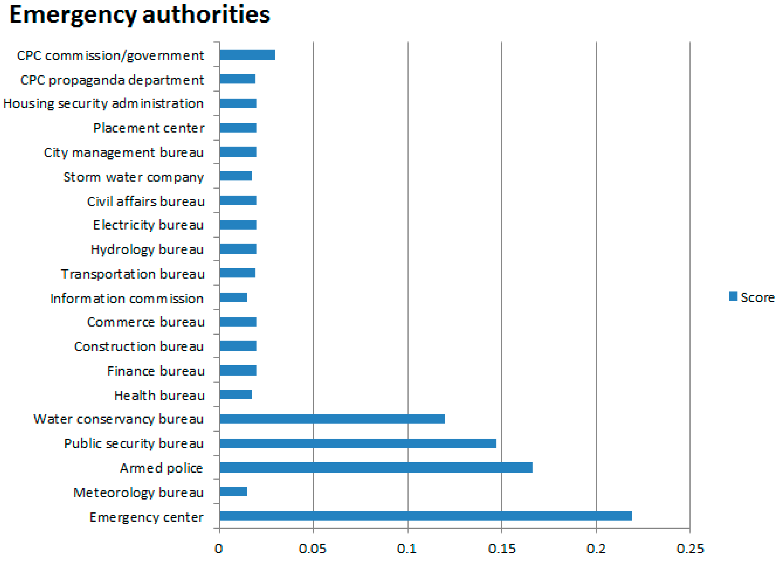
Based on the statistics of scores for various emergency departments in the simulation, the scores for various departments in the simulation are given in Figure 8. This wargame gave an overall score of 96.40 points. In terms of percentile, this score indicates that the simulation scheme is good, suggesting that emergency services may need to improve their emergency rescue capacity in addition to their normal operations, to improve the effectiveness of urban waterlogging disaster emergency evacuation plans for residents.

5. Conclusions

Using wargame technology for the evacuation of residents affected by urban waterlogging disasters simulates the “fight” against disasters. It is also an important measure to deduct “reasonable emergency responses” and “emergency response failures”. The simulation provides a reliable basis for training emergency response teams and coordinating emergency units. Traditional resident evacuation processes are carried out in accordance with emergency plans. Whether the emergency plans are fully realistic is yet to be tested. Therefore, advanced simulations to find problems in emergency plans or emergency procedures, and fixing problems in time, could reduce loss brought about by disasters. This investigation studied potential issues incorporating both qualitative and quantitative aspects. In determining the various phases of the emergency response process, the main factor considered was the duration taken by an emergency response unit to organize and assist in resident evacuation. The overall duration was the basis for establishing the starting, ending, expected and sustained phases. The settings were somewhat arbitrary. In future studies, in addition to using duration as the standard, we must also consider the coordination capabilities of each emergency rescue and response unit, such that the simulation for starting, ending, and sustained phases is more reasonable. Additionally, this article simulated and evaluated only one waterlogging disaster emergency evacuation plan. In actual operations, all existing emergency plans may be simulated and evaluated to provide a basis for decision-making in resident evacuation.

Acknowledgments

This study was financially supported by the National Natural Science Fund under Grants No. 41501557, No. 41371495 and No. 41501559. In addition, Jilin Province Science and Technology Department of youth fund under No. 20150520081JH provided further funds. We thank the editor and the anonymous reviewers for their helpful comments.

Author Contributions

Jiquan Zhang was responsible for the original idea and the theoretical aspects of the paper. Yingyue Sun was responsible for the data sorting while Xiaojing Liu was responsible for the drawing. Peng Chen drafted the manuscript and all authors read and revised the final manuscript.

Conflicts of Interest

The authors declare no conflict of interest.

References

  1. Ye, L.; Gong, L.; Liu, Z. Research and Modeling of a Rehearsal System of Naval Battle. Comput. Digit. Eng. 2011, 39, 58–61. (In Chinese) [Google Scholar]
  2. Shi, C.; Liu, B. Research on the Rehearsal & Evaluation System Based on Simulation. Tactical Missile Technol. March 2012, 1, 122–124. (In Chinese) [Google Scholar]
  3. Kong, W. The ADMS disaster management simulation system. Mod. Occup. Saf. 2011, 11, 107–108. (In Chinese) [Google Scholar]
  4. Darken, R.; McDowell, P.; Johnson, E. Projects in VR: The Delta3D open source game engine. IEEE Comput. Graph. Appl. 2005, 25, 10–12. [Google Scholar] [CrossRef] [PubMed]
  5. Li, Y.; Yao, F. Confrontational CISR simulation training system based on high level architecture. Command Inf. Syst. Technol. 2012, 3, 5–7. (In Chinese) [Google Scholar]
  6. Li, J.; Ji, Z. The design and implementation of “AKY-MCP” a mobile major accidents monitoring and command platform. J. Saf. Sci. Technol. 2009, 5, 77–80. (In Chinese) [Google Scholar]
  7. Chen, M.; Jiang, B.; Li, L. The design of urban emergency management system base on the Wargame theory. Chin. J. Environ. Manag. 2014, 6, 38–42. (In Chinese) [Google Scholar]
  8. Li, Q. Analysis and design of simulated emergency exercise system platform. J. Saf. Sci. Technol. 2012, 3, 026. (In Chinese) [Google Scholar]
  9. Ma, Y.; Zhang, X.; Ma, Y.; Lian, D.; Sun, Y. Emergency Drills Program Dynamic Deduction System. Comput Syst Appl. 2013, 2, 64–67. (In Chinese) [Google Scholar]
  10. Chen, P.; Zhang, J.; Yan, D. Numerical Simulation and Visualization of Urban Rainstorm Waterlogging Based on GIS—A Case Study of Daoli District in Haerbin City. J. Catastrophol. 2011, 26, 69–72. (In Chinese) [Google Scholar]
  11. Perla, P. The Art of Wargaming; Naval Institute Press: Annapolis, MD, USA, 2012. [Google Scholar]
  12. Xu, X.; Wang, S. Modern Battle Simulation; Science Press: Beijing, China, 2001. (In Chinese) [Google Scholar]
  13. Yang, K.; Yuan, W. Analysis of New Competitive Economics to Urban development’ Dynamics in Economic Globalization. Urban Res. 2000, 2, 19–22. (In Chinese) [Google Scholar]
  14. Chen, R.; Chen, Q. Analysis of causes for urban water logging in Nanning city. GX Water Resour. Hydropower Eng. 2009, 11, 26–27. (In Chinese) [Google Scholar]
  15. Zhang, W.; Li, S.; Shi, Z. Formation causes and coping strategies of urban rainstorm waterlogging in China. J. Nat. Disasters 2012, 21, 180–184. (In Chinese) [Google Scholar]
  16. Zhuang, J. The Causes of Waterlogging and the Measures of Harnessing for Jiangnan Zone of Quanzhou. Water Conserv. Sci. Technol. Econ. 2006, 12, 553–555. (In Chinese) [Google Scholar]
  17. Wang, J.; Xue, C.; Xie, Y.; Jin, L.; Xue, R. Causalative Analysis of Urban Waterlogging Induced by Severe Rainfall in Xi’an with Numerical Model. Meteorol. Sci. Technol. 2008, 36, 772–774. (In Chinese) [Google Scholar]
  18. Guo, X.; Ren, G.; Guo, Y. Influential factors for city waterlogging and the meteorological Service. J. Catastrophol. 2008, 23, 46–49. (In Chinese) [Google Scholar]
  19. Li, J.; Che, W. Rainwater problems and countermeasures for sustainable development in cities. Urban Environ. Urban Ecol. 2005, 18, 5–8. (In Chinese) [Google Scholar]
  20. Zoppou, C. Review of urban storm water models. Environ. Model. Softw. 2001, 16, 195–231. [Google Scholar] [CrossRef]
  21. Geng, H.; Wu, Z.; Ji, H.; Chen, H. GIS-Based Risk Zonation of Flood Disasters in Jiading District of Shanghai. J. Catastrophol. 2015, 30, 96–101. (In Chinese) [Google Scholar]
  22. Yin, Z.; Xu, S.; Yin, J.; Wang, J. Small-scale Based Scenario Modeling and Disaster Risk Assessment of Urban Rainstorm Waterlogging. Acta Geogr. Sin. 2010, 65, 553–562. (In Chinese) [Google Scholar]
  23. Yang, Q.; Jia, A. Research on Inundation Area of Flood Disaster and Evacuation Plan Based on ArcGIS. Water Resour. Power 2011, 29, 35–36. (In Chinese) [Google Scholar]
  24. Liu, Y. War Game and War Game Exercise; National Defense University Press: Beijing, China, 2013. (In Chinese) [Google Scholar]
  25. Perla, P.P.; McGrady, E.D. Why wargaming works. Naval War Coll. Rev. 2011, 64, 111. [Google Scholar]
  26. Blank, D. Military Wargaming: A commercial Battlefield. Jane’s Defence Weekly, 4 February 2004. [Google Scholar]
  27. Wang, G.; Liu, H.; Zhu, N. A Survey of War Games Technology. Ordnance Ind. Autom. 2012, 31, 39–45. (In Chinese) [Google Scholar]
  28. Xia, B.; Zhang, X.; Wang, H. Emergency Drills and Exercises Design; Contemporary China Publishing House: Beijing, China, 2011. (In Chinese) [Google Scholar]
  29. Peng, C.; Ju, R.; Yang, J.; Huang, K. Analysis of Technology of Modern Wargaming. J. Syst. Simul. 2009, 21, 97–100. (In Chinese) [Google Scholar]
  30. Ross, D. Designing a System on System Wargame; US Air Force Research Lab.: Wright-Patterson, OH, USA, 2006. [Google Scholar]
  31. Zhang, K.; Qiu, X.; Peng, C.; Cehn, B.; Huang, K. Design and Implementation of Distributed Simulation Experiment Management System. J. Syst. Simul. 2008, 20, 6627–6630. (In Chinese) [Google Scholar]
  32. Alberts, D.S. Understanding Information Age Warfare; CCRP Publications: Washington, DC, USA, 2001; pp. 22–24. [Google Scholar]
  33. Marsland, T.A. A Review of Game Tree Pruning. ICGA J. 1986, 9, 3–19. [Google Scholar]
  34. Theresa-Marie, R. Computer games’ influence on scientific and information visualization. Computer 2000, 33, 154–159. [Google Scholar]
  35. Chen, P.; Zhang, J.; Jiang, X.; Liu, X.; Bao, Y.; Sun, Y. Scenario simulation-based assessment of trip difficulty for urban residents under rainstorm waterlogging. Int. J. Environ. Res. Public Health 2012, 9, 2057–2074. [Google Scholar] [CrossRef] [PubMed]
  36. Chen, P.; Zhang, J.; Zhang, L.; Sun, Y. Evaluation of resident evacuations in urban rainstorm waterlogging disasters based on scenario simulation: Daoli district (Harbin, China) as an example. Int. J. Environ. Res. Public Health 2014, 11, 9964–9980. [Google Scholar] [CrossRef] [PubMed]
  37. Chen, P.; Zhang, J.; Sun, Y.; Liu, X. Emergency sheltering of urban residents in waterlogging disaster by war game exercise theory and method. Yangtze River 2016, 47, 8–11. (In Chinese) [Google Scholar]
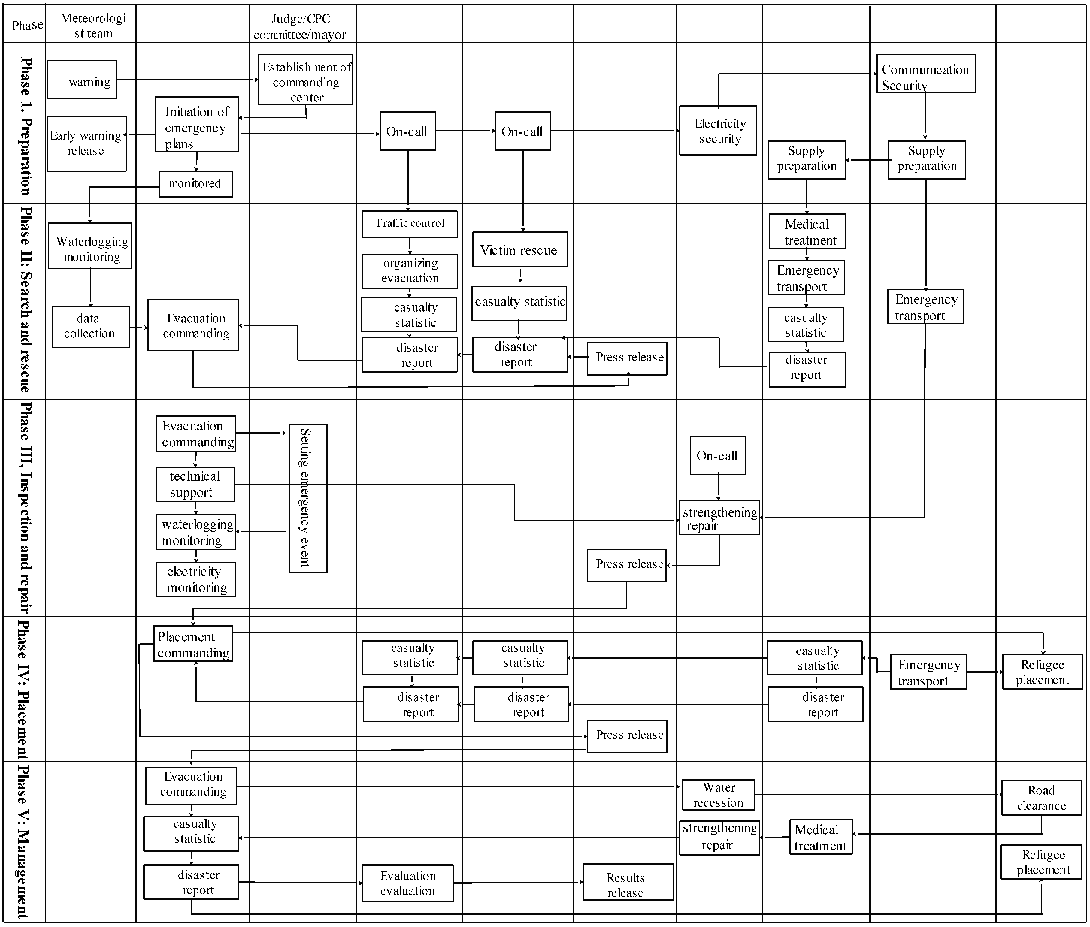
Figure 1. Schematic diagram for the wargame of waterlogging disaster evacuation. CPC: Communist Party of China.
Ijerph 13 01260 g001
Figure 2. Diagram of the study area.
Ijerph 13 01260 g002
Figure 3. The fight situation in the first stage.
Ijerph 13 01260 g003
Figure 4. The fight situation in the second stage.
Ijerph 13 01260 g004
Figure 5. The fight situation in 3-stage.
Ijerph 13 01260 g005
Figure 6. The fight situation in the fourth stage.
Ijerph 13 01260 g006
Figure 7. The fight situation in 5-stage.
Ijerph 13 01260 g007
Figure 8. Comparison of scores for all emergency departments (See other figures for translation of Government departments).
Ijerph 13 01260 g008
Table 1. Responsibilities of emergency departments in the wargame of an urban waterlogging disaster.
DepartmentResponsibility
Judge/Ruling GroupSetting emergency events, evaluation
Emergency CenterPlan initiation, monitoring, reporting, evacuation commanding
Bureau of MeteorologyWarning, weather monitoring, media
Armed PoliceSearch, rescue and organize resident, evacuation, repair, emergency transport
Public Security BureauResident evacuation, traffic control, casualty statistics, disaster report
Water Conservancy BureauWater monitoring, reinforcement repair
Health BureauWound treatment, epidemic prevention
Finance BureauSupply preparation, emergency fund raising
Construction BureauSupply preparation
Commerce BureauSupply preparation
Transportation BureauTraffic control, traffic redirection
Hydrology BureauWater monitoring, data collection, technical support
Power Supply BureauPower security
Civil Affairs BureauDisaster statistics, set up and select emergency shelters
Drainage CompanyRoad water drainage
Urban Management Bureau.Road cleaning
Settlement Management CenterEmergency shelter management
Housing Security BureauReinforcing repair
Propaganda DepartmentMedia
Information CommissionCommunication security
Table 2. Rainstorm intensity and rounds agreement.
RoundsP = 0.5aP = 1aP = 2aP = 3aP = 5a
10.0380.0540.0690.0780.089
20.0430.0600.0770.0870.100
30.0490.0680.0880.0990.113
40.0560.0780.1010.1140.130
50.0660.0920.1180.1330.153
60.0790.1100.1420.1600.184
70.0980.1370.1760.1990.228
80.1270.1780.2290.2590.296
90.1770.2470.3180.3590.411
100.2720.3810.4900.5540.634
110.5070.7100.9131.0321.182
121.4622.0482.6342.9763.408
130.5070.7100.9131.0321.182
140.2720.3810.4900.5540.634
150.1770.2470.3180.3590.411
160.1270.1780.2290.2590.296
170.0980.1370.1760.1990.228
180.0790.1100.1180.1330.153
The intervals among rounds is ten minutes.
Table 3. The flexible decision table of vehicles.
TypesFlexible Grids
Hospital car30
Transport cart24
Emergency communications vehicles36
Truck18
Boat18
Charge boat30
Cars35
Motorcycle30
Table 4. The first stage (preparation stage) to deduce the command score table.
CommandDestinationStartEndExpectedSustainingScore
Meteorology BureauIssue warningCPC commission/government11111
WarningResidents24340.75
CPC commission/governmentEstablish emergency command centerHexagon grid11111
Emergency command centerPlan initiationEmergency command center11111
MonitorHexagon grid2994990.7
Public security bureauOn-call26251
Armed policeOn-call26251
Health bureauSupply preparationHealth bureau26251
Finance bureauSupply preparationFinance bureau26251
Construction bureauSupply preparationConstruction bureau26251
Commerce bureauSupply preparationCommerce bureau26251
Transportation bureauSupply preparationTransportation bureau26251
Information commissionCommunication assuranceInformation commission2996990.5
Note: The starting phase, ending phase, expected phase and sustained phase were set based on the specific emergency department, where 99 indicates the ending phase or sustained phase until the end of the simulation.
Table 5. Scoring scheme for search and rescue phase.
CommandDestinationStartEndExpectedSustainedScore
Emergency command centerRescue commandEmergency command center77721
Police DepartmentTraffic controlRoad812750.88
Resident evacuationSubdivision, settlements710741
Casualty countPolice department10121031
Status reportEmergency command center10121031
Armed policeRescueResident712751
Casualty countArmed police10121031
Status reportEmergency command center10121031
Hydrology bureau and water conservancy bureauStorm water monitoringHexagon812861
Data collectionHydrology bureau812861
Health bureauWound treatmentWounded residents812861
Emergency transportHexagon812861
Casualty countHealth bureau812861
Status reportEmergency command center812861
Electricity BureauPower supply securityElectricity bureau712761
Meteorology bureauPress releaseResidents912770.75
Communication commissionPress releaseResidents912770.75
Transportation bureauEmergency transportHexagon net911951
Table 6. Scoring scheme for reinforcement phase.
CommandTargetStartEndExpectedSustainedScore
Emergency command centerEvacuation commandEmergency command center13161351
Technical supportEmergency command center13161351
Monitor14161461
Ruling groupTraffic controlWater monitor site1313131--
Traffic controlCommunication network1313131--
Traffic controlElectric facility1313131--
Meteorology bureauEmergency transportMobile monitoring vehicle15171430.5
Information commissionEmergency transportMobile monitoring vehicle14171441
Armed policeReinforcementDamaged electric facility16181440.6
Propaganda departmentPress releaseResidents14181451
Table 7. Scoring scheme for placement phase.
CommandTargetStartEndExpectedSustainedScore
Emergency command centerEvacuation commandEmergency command center19231981
Civil affairs bureauSettlement site selectionTemporary accommodation20232031
Report to placement centerTemporary accommodation21232131
Transportation departmentsEmergency transportationHexagon20232031
Emergency transportationHexagon22232130.86
Civil affairs bureauCasualty countCivil affairs bureau23232311
Status reportEmergency command center23232311
Health bureauCasualty reportHealth bureau23222311
Status reportEmergency command center24222310
Public Security DepartmentCasualty reportPublic Security Department23232311
Status reportEmergency command center23232311
Propaganda departmentPress releaseResidents202402160.8
Table 8. Scoring scheme for management phase.
CommandTargetStartEndExpectedSustainedScore
Emergency command centerEmergency commandPlacement center25302551
Storm water companyWater removalHexagon grid26302550.83
City management bureauRoad cleaningHexagon grid25302551
Health bureauEpidemic preventionHexagon grid26302550.83
Placement management centerResident placementResidents24302451
Housing security administrationReinforcement repairSite27302741
Propaganda bureauPress releaseResidents26302661
Table 9. Evaluation of wargame simulating waterlogging disaster evacuation.
DepartmentMean ScoreWeightDepartment ScoreDepartmentMean ScoreWeightDepartment Score
Emergency center0.9630.220.219Transportation bureau0.9650.020.019
Meteorology bureau0.7500.020.015Hydrology bureau1.0000.020.020
Armed police0.9200.180.166Electricity bureau1.0000.020.020
Public security bureau0.9830.150.147Civil affairs bureau1.0000.020.020
Water conservancy bureau1.0000.120.120Storm water company0.8300.020.017
Health bureau0.8540.020.017City management bureau1.0000.020.020
Finance bureau1.0000.020.020Placement center1.0000.020.020
Construction bureau1.0000.020.020Housing security administration1.0000.020.020
Commerce bureau1.0000.020.020CPC propaganda department0.9330.020.019
Information commission0.750.020.015CPC commission/government1.0000.030.030
Total 75.90Total 20.50