Predictors of Daily Mobility of Adults in Peri-Urban South India

 , , , , ,
Abstract
:1. Introduction
2. Materials and Methods
2.1. Study Design
2.2. GPS Data Collection and Processing
2.3. Study Population
2.4. Time-Activity Diary
2.5. Geographic Information System (GIS)-Derived Data
2.6. Other Data
2.7. Mobility Indicators
2.8. Analyses
3. Results
4. Discussion
5. Conclusions
Supplementary Materials
Acknowledgments
Author Contributions
Conflicts of Interest
References
- Jerrett, M.; Arain, A.; Kanaroglou, P.; Beckerman, B.; Potoglou, D.; Sahsuvaroglu, T.; Morrison, J.; Giovis, C. A review and evaluation of intraurban air pollution exposure models. J. Expo. Anal. Environ. Epidemiol. 2005, 15, 185–204. [Google Scholar] [CrossRef] [PubMed]
- Dewulf, B.; Neutens, T.; Lefebvre, W.; Seynaeve, G.; Vanpoucke, C.; Beckx, C.; Van de Weghe, N. Dynamic assessment of exposure to air pollution using mobile phone data. Int. J. Health Geogr. 2016, 15, 14. [Google Scholar] [CrossRef] [PubMed]
- Nethery, E.; Mallach, G.; Rainham, D.; Goldberg, M.S.; Wheeler, A.J. Using Global Positioning Systems (GPS) and temperature data to generate time-activity classifications for estimating personal exposure in air monitoring studies: An automated method. Environ. Health 2014, 13, 33. [Google Scholar] [CrossRef] [PubMed]
- Park, Y.M.; Kwan, M.-P. Individual exposure estimates may be erroneous when spatiotemporal variability of air pollution and human mobility are ignored. Health Place 2017, 43, 85–94. [Google Scholar] [CrossRef] [PubMed]
- Smith, J.D.; Mitsakou, C.; Kitwiroon, N.; Barratt, B.M.; Walton, H.A.; Taylor, J.G.; Anderson, H.R.; Kelly, F.J.; Beevers, S.D. London hybrid exposure model: Improving human exposure estimates to NO2 and PM2.5 in an urban setting. Environ. Sci. Technol. 2016, 50, 11760–11768. [Google Scholar] [CrossRef] [PubMed]
- Setton, E.; Marshall, J.D.; Brauer, M.; Lundquist, K.R.; Hystad, P.; Keller, P.; Cloutier-Fisher, D. The impact of daily mobility on exposure to traffic-related air pollution and health effect estimates. J. Expo. Sci. Environ. Epidemiol. 2011, 21, 42–48. [Google Scholar] [CrossRef] [PubMed]
- Spalt, E.W.; Curl, C.L.; Allen, R.W.; Cohen, M.; Adar, S.D.; Stukovsky, K.H.; Avol, E.; Castro-Diehl, C.; Nunn, C.; Mancera-Cuevas, K.; et al. Time-location patterns of a diverse population of older adults: The Multi-Ethnic Study of Atherosclerosis and Air Pollution (MESA Air). J. Expo. Sci. Environ. Epidemiol. 2016, 26, 349–355. [Google Scholar] [CrossRef] [PubMed]
- Schweizer, C.; Edwards, R.D.; Bayer-Oglesby, L.; Gauderman, W.J.; Ilacqua, V.; Juhani Jantunen, M.; Lai, H.K.; Nieuwenhuijsen, M.; Künzli, N. Indoor time-microenvironment–activity patterns in seven regions of Europe. J. Expo. Sci. Environ. Epidemiol. 2007, 17, 170–181. [Google Scholar] [CrossRef] [PubMed]
- Marshall, J.D.; Granvold, P.W.; Hoats, A.S.; McKone, T.E.; Deakin, E.; Nazaroff, W.W. Inhalation intake of ambient air pollution in California’s South Coast Air Basin. Atmos. Environ. 2006, 40, 4381–4392. [Google Scholar] [CrossRef]
- Pandey, R.N.; Hirway, I. Conducting the time use survey-Indian experience. In Proceedings of the Expert Group Meeting on Methods for Conducting Time-Use Surveys, New York, NY, USA, 23–27 October 2000; pp. 23–27. [Google Scholar]
- Freeman, N.C.G.; de Tejada, S.S. Methods for collecting time/activity pattern information related to exposure to combustion products. Chemosphere 2002, 49, 979–992. [Google Scholar] [CrossRef]
- Thierry, B.; Chaix, B.; Kestens, Y. Detecting activity locations from raw GPS data: A novel kernel-based algorithm. Int. J. Health Geogr. 2013, 12, 14. [Google Scholar] [CrossRef] [PubMed]
- Kestens, Y.; Thierry, B.; Chaix, B. Re-creating daily mobility histories for health research from raw GPS tracks: Validation of a kernel-based algorithm using real-life data. Health Place 2016, 40, 29–33. [Google Scholar] [CrossRef] [PubMed]
- Huss, A.; Beekhuizen, J.; Kromhout, H.; Vermeulen, R. Using GPS-derived speed patterns for recognition of transport modes in adults. Int. J. Health Geogr. 2014, 13, 40. [Google Scholar] [CrossRef] [PubMed]
- Donaire-Gonzalez, D.; Valentín, A.; de Nazelle, A.; Ambros, A.; Carrasco-Turigas, G.; Seto, E.; Jerrett, M.; Nieuwenhuijsen, M.J. Benefits of mobile phone technology for personal environmental monitoring. JMIR mHealth uHealth 2016, 4, e126. [Google Scholar] [CrossRef] [PubMed]
- Vazquez-Prokopec, G.M.; Stoddard, S.T.; Paz-Soldan, V.; Morrison, A.C.; Elder, J.P.; Kochel, T.J.; Scott, T.W.; Kitron, U. Usefulness of commercially available GPS data-loggers for tracking human movement and exposure to dengue virus. Int. J. Health Geogr. 2009, 8, 68. [Google Scholar] [CrossRef] [PubMed]
- Lyseen, A.; Hansen, H.; Harder, H.; Jensen, A.; Mikkelsen, B. Defining neighbourhoods as a measure of exposure to the food environment. Int. J. Environ. Res. Public Health 2015, 12, 8504–8525. [Google Scholar] [CrossRef] [PubMed]
- Jankowska, M.M.; Schipperijn, J.; Kerr, J. A framework for using GPS data in physical activity and sedentary behavior studies. Exerc. Sport Sci. Rev. 2015, 43, 48–56. [Google Scholar] [CrossRef] [PubMed]
- Chaix, B.; Kestens, Y.; Duncan, S.; Merrien, C.; Thierry, B.; Pannier, B.; Brondeel, R.; Lewin, A.; Karusisi, N.; Perchoux, C.; et al. Active transportation and public transportation use to achieve physical activity recommendations? A combined GPS, accelerometer, and mobility survey study. Int. J. Behav. Nutr. Phys. Act. 2014, 11, 124. [Google Scholar] [CrossRef] [PubMed]
- Perchoux, C.; Kestens, Y.; Thomas, F.; van Hulst, A.; Thierry, B.; Chaix, B. Assessing patterns of spatial behavior in health studies: Their socio-demographic determinants and associations with transportation modes (the RECORD Cohort Study). Soc. Sci. Med. 2014, 119, 64–73. [Google Scholar] [CrossRef] [PubMed]
- Chaix, B.; Kestens, Y.; Perchoux, C.; Karusisi, N.; Merlo, J.; Labadi, K. An interactive mapping tool to assess individual mobility patterns in neighborhood studies. Am. J. Prev. Med. 2012, 43, 440–450. [Google Scholar] [CrossRef] [PubMed]
- Wettstein, M.; Wahl, H.-W.; Shoval, N.; Auslander, G.; Oswald, F.; Heinik, J. Identifying mobility types in cognitively heterogeneous older adults based on GPS-tracking: What discriminates best? J. Appl. Gerontol. 2015, 34, 1001–1027. [Google Scholar] [CrossRef] [PubMed]
- Kinra, S.; Radha Krishna, K.; Kuper, H.; Rameshwar Sarma, K.; Prabhakaran, P.; Gupta, V.; Walia, G.K.; Bhogadi, S.; Kulkarni, B.; Kumar, A.; et al. Cohort profile: Andhra pradesh children and parents study (APCAPS). Int. J. Epidemiol. 2014, 43, 1417–1424. [Google Scholar] [CrossRef] [PubMed]
- Tonne, C.; Salmon, M.; Sanchez, M.; Sreekanth, V.; Bhogadi, S.; Sambandam, S.; Balakrishnan, K.; Kinra, S.; Marshall, J.D. Integrated assessment of exposure to PM2.5 in South India and its relation with cardiovascular risk: Design of the CHAI observational cohort study. Int. J. Hyg. Environ. Health 2017. [Google Scholar] [CrossRef]
- Elvidge, C.D.; Baugh, K.E.; Kihn, E.A.; Kroehl, H.W.; Davis, E.R.; Davis, C.W. Relation between satellite observed visible-near infrared emissions, population, economic activity and electric power consumption. Int. J. Remote Sens. 1997, 18, 1373–1379. [Google Scholar] [CrossRef]
- Baugh, K.; Elvidge, C.D.; Ghosh, T.; Ziskin, D. Development of a 2009 Stable Lights Product using DMSP-OLS data. Proc. Asia Pac. Adv. Netw. 2010, 30, 114–130. [Google Scholar] [CrossRef]
- R Core Team. R: A Language and Environment for Statistical Computing; R Foundation for Statistical Computing: Vienna, Austria, 2015. [Google Scholar]
- Revelle, W. Psych: Procedures for Personality and Psychological Research; R Package Version 1.6.9; Northwestern University: Evanston, IL, USA, 2016. [Google Scholar]
- Bates, D.; Maechler, M.; Bolker, B.; Walker, S. Fitting linear mixed-effects models using lme4. J. Stat. Softw. 2015, 67, 1–48. [Google Scholar] [CrossRef]
- Wei, T.; Simko, V. Corrplot: Visualization of a Correlation Matrix, R Package Version 0.77. 2016.
- Wickham, H. Ggplot2: Elegant Graphics for Data Analysis; R Package Version 2.2.0; Springler: New York, NY, USA, 2009. [Google Scholar]
- Wickham, H. Tidyverse: Easily Install and Load “Tidyverse” Packages, R Package Version 1.1.1. 2017.
- Saksena, S.; Prasad, R.K.; Shankar, V.R. Daily exposure to air pollutants in indoor, outdoor and in-vehicle micro-environments: A pilot study in Delhi. Indoor Built Environ. 2007, 16, 39–46. [Google Scholar] [CrossRef]
- Leech, J.A.; Nelson, W.C.; Burnett, R.T.; Aaron, S.; Raizenne, M.E. It’s about time: A comparison of Canadian and American time–activity patterns. J. Expo. Anal. Environ. Epidemiol. 2002, 12, 427–432. [Google Scholar] [CrossRef] [PubMed]
- Wu, X.; Bennett, D.H.; Lee, K.; Cassady, D.L.; Ritz, B.; Hertz-Picciotto, I. Longitudinal variability of time-location/activity patterns of population at different ages: A longitudinal study in California. Environ. Health 2011, 10, 80. [Google Scholar] [CrossRef] [PubMed]
- Matz, C.J.; Stieb, D.M.; Brion, O. Urban-rural differences in daily time-activity patterns, occupational activity and housing characteristics. Environ. Health 2015, 14, 88. [Google Scholar] [CrossRef] [PubMed]
- Hirsch, J.A.; Winters, M.; Clarke, P.; McKay, H. Generating GPS activity spaces that shed light upon the mobility habits of older adults: A descriptive analysis. Int. J. Health Geogr. 2014, 13, 51. [Google Scholar] [CrossRef] [PubMed]
- Manoj, M.; Verma, A.; Navyatha, M. Commute travel and its effect on housing tenure choice of males and females living in the urban and rural areas of Bangalore city in India. J. Transp. Geogr. 2015, 45, 62–69. [Google Scholar] [CrossRef]
- Vanwolleghem, G.; Schipperijn, J.; Gheysen, F.; Cardon, G.; de Bourdeaudhuij, I.; van Dyck, D. Children’s GPS-determined versus self-reported transport in leisure time and associations with parental perceptions of the neighborhood environment. Int. J. Health Geogr. 2016, 15, 16. [Google Scholar] [CrossRef] [PubMed]
- International Institute for Population Sciences and ORC Macro. National Family Health Survey (NFHS-II) 1998–99: India; International Institute for Population Sciences and ORC Macro: Mumbai, India, 2000. [Google Scholar]
- Madsen, T.; Schipperijn, J.; Christiansen, L.B.; Nielsen, T.S.; Troelsen, J. Developing suitable buffers to capture transport cycling behavior. Front. Public Health 2014, 2, 61. [Google Scholar] [CrossRef] [PubMed]
- Matz, C.; Stieb, D.; Davis, K.; Egyed, M.; Rose, A.; Chou, B.; Brion, O. Effects of Age, season, gender and urban-rural status on time-activity: Canadian human activity pattern survey 2 (CHAPS 2). Int. J. Environ. Res. Public Health 2014, 11, 2108–2124. [Google Scholar] [CrossRef] [PubMed]
- Srinivasan, S.; Rogers, P. Travel behavior of low-income residents: Studying two contrasting locations in the city of Chennai, India. J. Transp. Geogr. 2005, 13, 265–274. [Google Scholar] [CrossRef]
- Isaacs, K.; McCurdy, T.; Glen, G.; Nysewander, M.; Errickson, A.; Forbes, S.; Graham, S.; McCurdy, L.; Smith, L.; Tulve, N.; et al. Statistical properties of longitudinal time-activity data for use in human exposure modeling. J. Expo. Sci. Environ. Epidemiol. 2013, 23, 328–336. [Google Scholar] [CrossRef] [PubMed]
- Hirway, I.; Jose, S. Understanding women’s work using time-use statistics: The case of India. Fem. Econ. 2011, 17, 67–92. [Google Scholar] [CrossRef]
- Lahiri-dutt, K.; Sil, P. Women’s “double day” in middle-class homes in small-town India. Contemp. South Asia 2014, 22, 389–405. [Google Scholar] [CrossRef]
- Sharp, G.; Denney, J.T.; Kimbro, R.T. Multiple contexts of exposure: Activity spaces, residential neighborhoods, and self-rated health. Soc. Sci. Med. 2015, 146, 204–213. [Google Scholar] [CrossRef] [PubMed]
- Dons, E.; Int Panis, L.; van Poppel, M.; Theunis, J.; Willems, H.; Torfs, R.; Wets, G. Impact of time-activity patterns on personal exposure to black carbon. Atmos. Environ. 2011, 45, 3594–3602. [Google Scholar] [CrossRef]


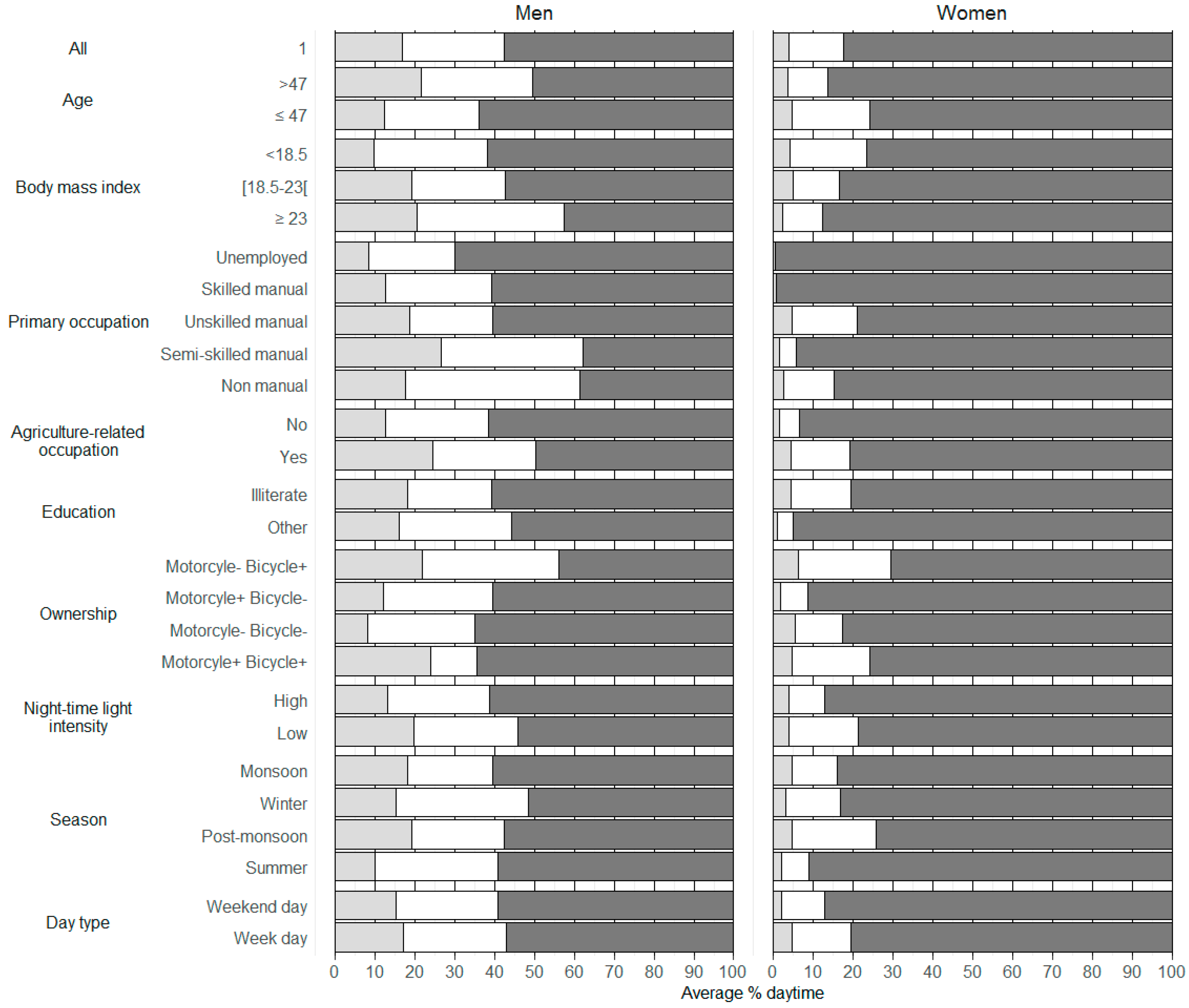
| Percent daytime spent in: | 50-m residential buffer |
| 100-m residential buffer | |
| 400-m residential buffer | |
| 800-m residential buffer | |
| 1600-m residential buffer | |
| Village boundaries | |
| Percent daytime spent *: | At home |
| In activity locations | |
| In trips | |
| Activity locations visited: | Total number |
| % inside village boundaries | |
| % inside the 1-standard deviational ellipse | |
| Average distance from home | |
| Trips: | Number of trips ≥5 min |
| Average speed | |
| Activity spaces: | Minimum convex polygon: |
| Perimeter | |
| Surface | |
| Compactness | |
| Centroid-to-home distance | |
| 1-standard deviational ellipse: | |
| Perimeter | |
| Surface | |
| Compactness | |
| Centroid-to-home distance | |
| Linear distance travelled from home: | Mean |
| Median |
| N participants | All | Men | Women | p-Value |
|---|---|---|---|---|
| 47 | 23 | 24 | ||
| Age (years), m (sd) | 44 (13.7) | 40 (16.1) | 49 (8.9) | 0.01 |
| min–max | 20–65 | 20–65 | 27–64 | |
| Number of GPS sessions | ||||
| m (sd) | 4.1 (1.7) | 4.1 (1.8) | 4.2 (1.6) | 0.62 |
| Only 1 session, n (%) | 7 (14.9) | 4 (17.4) | 3 (12.5) | |
| GPS recording time (hours), m (sd) | 16.3 (0.6) | 16.4 (0.7) | 16.2 (0.5) | 0.04 |
| min–max | 13.9–19.2 | 13.9–19.2 | 14.2–17.5 | |
| Marital status, married, n (%) | 34 (72) | 16 (70) | 18 (75) | 0.01 |
| Education level, illiterate, n (%) | 25 (53) | 6 (26) | 19 (79) | <0.001 |
| Current smoker, n (%) | 6 (13) | 6 (26) | 0 | 0.03 |
| Primary occupation, n (%) | ||||
| Unemployed | 4 (9) | 2 (9) | 2 (8) | 0.06 |
| Unskilled manual | 26 (55) | 9 (39) | 17 (71) | |
| Semi-skilled manual | 5 (11) | 2 (9) | 3 (13) | |
| Skilled manual | 10 (21) | 9 (39) | 1 (4) | |
| Non manual | 2 (4) | 1 (4) | 1 (4) | |
| Agriculture-related occupation, n (%) | 26 (55) | 8 (35) | 18 (75) | 0.01 |
| Body mass index (kg/m2), n (%) | ||||
| <18.5 | 13 (28) | 6 (27) | 7 (29) | 0.10 |
| 18.5−23.0 | 23 (50) | 14 (64) | 9 (38) | |
| ≥23.0 | 10 (22) | 2 (9) | 8 (33) | |
| Household ownership, n (%) | ||||
| Motorcycle−Bicycle− | 7 (15) | 3 (13) | 4 (17) | 0.87 |
| Motorcycle−Bicycle+ | 7 (15) | 4 (17) | 3 (12) | |
| Motorcycle+Bicycle− | 23 (49) | 12 (52) | 11 (46) | |
| Motorcycle+Bicycle+ | 10 (21) | 4 (17) | 6 (25) |
| All | Men | Women | |
|---|---|---|---|
| N Participant-Days | 192 | 91 | 101 |
| Percent daytime spent in: | |||
| 50-m buffer, m (sd) | 74 (25.3) | 62 (23.4) | 84 (22.4) |
| min–max | 22–100 | 22–100 | 38–100 |
| 100-m buffer | 76 (25.0) | 65 (23.8) | 85 (22.1) |
| 23–100 | 23–100 | 39–100 | |
| 400-m buffer | 80 (23.8) | 72 (24.0) | 87 (21.2) |
| 26–100 | 26–100 | 41–100 | |
| 800-m buffer | 83.5 (22.3) | 76 (23.1) | 91 (19.0) |
| 27–100 | 27–100 | 43–100 | |
| 1600-m buffer | 88 (20.1) | 82 (22.5) | 94 (15.9) |
| 27–100 | 27–100 | 45–100 | |
| Village boundaries | 78 (26.0) | 67 (27.0) | 87 (21.5) |
| 0–100 | 0–100 | 41–100 | |
| Activity locations visited: | |||
| Total number, m (sd) | 1.6 (1.8) | 2.0 (1.7) | 1.1 (1.7) |
| min–max | 0–10 | 0–10 | 0–8 |
| % in village boundaries | 26 (39.5) | 35 (41.3) | 18 (36.2) |
| 0–100 | 0–100 | 0–100 | |
| % in 1-standard deviational ellipse | 29 (40.1) | 42 (42.1) | 18 (34.6) |
| 0–100 | 0–100 | 0–100 | |
| Average distance from home in km | 2.3 (3.7) | 3.1 (4.4) | 1.0 (1.0) |
| 0–19 | 0–19 | 0–3 | |
| Trips: | |||
| Number (≥5 min), m (sd) | 3.0 (3.2) | 4.6 (3.5) | 1.5 (1.9) |
| min–max | 0–15 | 0–15 | 0–9 |
| Average speed in km/h | 4.2 (4.9) | 6.2 (6.0) | 2.2 (1.3) |
| 0–30 | 1–30 | 0–6 | |
| Linear distance travelled from home: | |||
| Mean distance in km, m (sd) | 0.6 (1.2) | 1.1 (1.5) | 0.2 (0.4) |
| min–max | 0–7 | 0–7 | 0–2 |
| Median distance in km | 0.5 (1.5) | 0.9 (2.1) | 0.2 (0.6) |
| 0–12 | 0–12 | 0–3 |
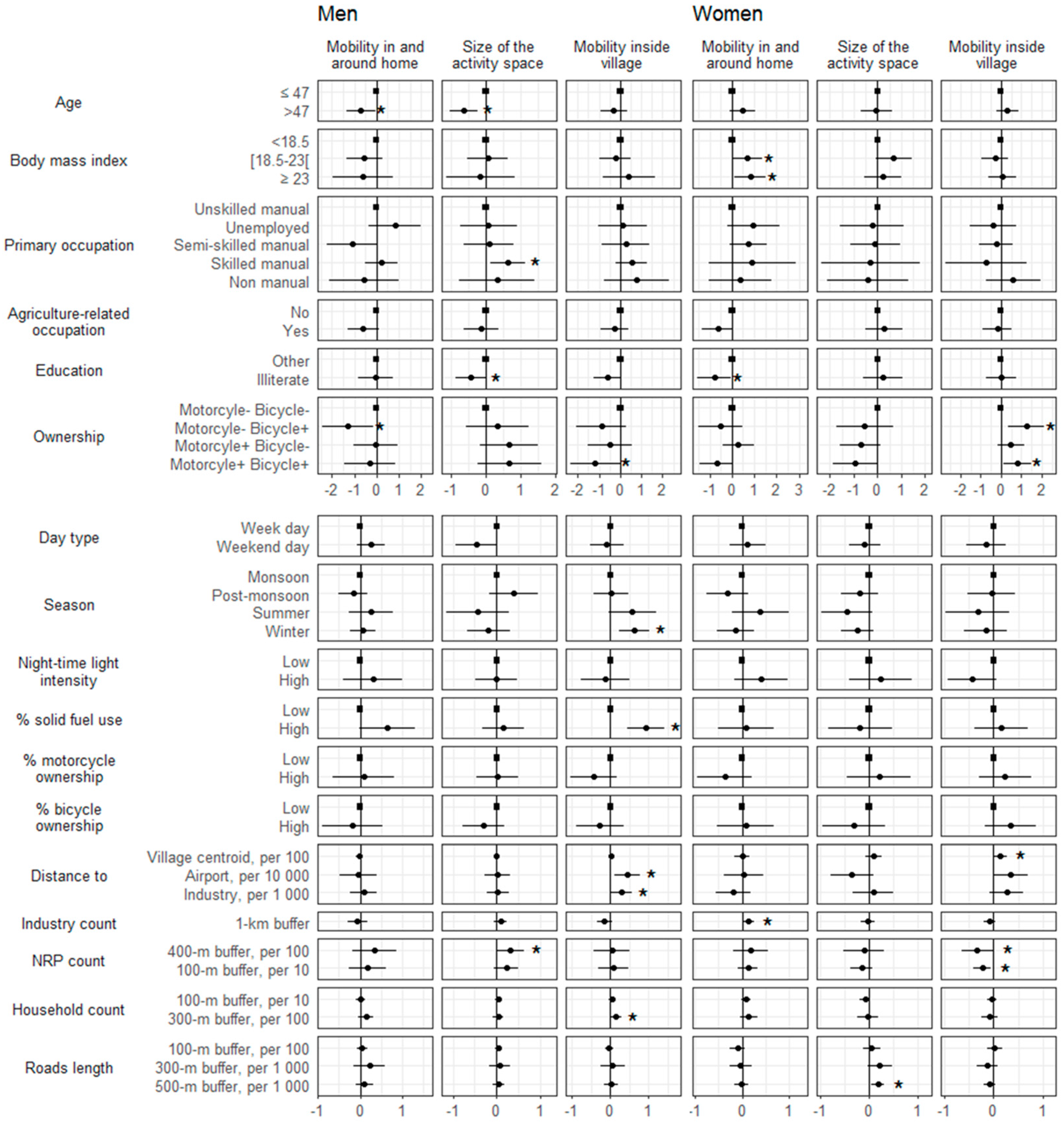
| Men | Women | |||||||
|---|---|---|---|---|---|---|---|---|
| Components Labels | Mobility in and around Home | Size of the Activity Space | Mobility inside Village | Circularity of the Activity Space | Median Distance Travelled from Home | Mobility in and around Home | Size of the Activity Space | Mobility inside Village |
| Proportion of total variability explained: | 27.6% | 24.3% | 9.3% | 9.5% | 9.8% | 37.5% | 41.9% | 6.4% |
| Percent daytime spent in: | ||||||||
| 50-m buffer | 0.90 | −0.84 | −0.50 | |||||
| 100-m buffer | 0.91 | −0.83 | −0.52 | |||||
| 400-m buffer | 0.84 | −0.38 | −0.78 | −0.56 | ||||
| 800-m buffer | 0.77 | −0.46 | −0.56 | −0.72 | ||||
| 1600-m buffer | 0.52 | −0.30 | −0.61 | −0.89 | ||||
| Village boundaries | 0.77 | −0.80 | −0.54 | |||||
| Percent daytime spent *: | ||||||||
| At home | 0.78 | −0.51 | −0.85 | −0.49 | ||||
| In activity locations | −0.42 | 0.80 | 0.88 | 0.40 | ||||
| In trips | −0.74 | −0.38 | 0.52 | 0.66 | 0.31 | |||
| Activity locations visited: | ||||||||
| Total number | −0.66 | 0.41 | 0.70 | 0.44 | ||||
| % inside 1−sd ellipse | −0.51 | 0.55 | 0.65 | 0.57 | ||||
| % inside village | 0.78 | 0.64 | ||||||
| Average distance from home | 0.63 | −0.40 | 0.38 | 0.52 | 0.83 | |||
| Trips: | ||||||||
| Number of trips ≥5 min | −0.82 | 0.57 | 0.50 | 0.45 | ||||
| Average speed | 0.60 | −0.46 | 0.37 | −0.68 | ||||
| Minimum convex polygon: | ||||||||
| Surface | 0.94 | 0.87 | ||||||
| Perimeter | 0.94 | 0.54 | 0.82 | |||||
| Compactness | 0.89 | −0.74 | ||||||
| Centroid–to–home distance | 0.65 | 0.50 | 0.82 | |||||
| 1-standard deviational ellipse: | ||||||||
| Surface | 0.96 | 0.34 | 0.85 | |||||
| Perimeter | 0.92 | 0.53 | 0.83 | |||||
| Compactness | 0.85 | −0.86 | −0.37 | |||||
| Centroid–to–home distance | −0.31 | 0.65 | 0.39 | 0.46 | 0.84 | |||
| Linear distance travelled from home: | ||||||||
| Mean | 0.72 | 0.55 | 0.50 | 0.84 | ||||
| Median | 0.84 | 0.36 | 0.78 | |||||
© 2017 by the authors. Licensee MDPI, Basel, Switzerland. This article is an open access article distributed under the terms and conditions of the Creative Commons Attribution (CC BY) license (http://creativecommons.org/licenses/by/4.0/).
Share and Cite
Sanchez, M.; Ambros, A.; Salmon, M.; Bhogadi, S.; Wilson, R.T.; Kinra, S.; Marshall, J.D.; Tonne, C. Predictors of Daily Mobility of Adults in Peri-Urban South India. Int. J. Environ. Res. Public Health 2017, 14, 783. https://doi.org/10.3390/ijerph14070783
Sanchez M, Ambros A, Salmon M, Bhogadi S, Wilson RT, Kinra S, Marshall JD, Tonne C. Predictors of Daily Mobility of Adults in Peri-Urban South India. International Journal of Environmental Research and Public Health. 2017; 14(7):783. https://doi.org/10.3390/ijerph14070783
Chicago/Turabian StyleSanchez, Margaux, Albert Ambros, Maëlle Salmon, Santhi Bhogadi, Robin T. Wilson, Sanjay Kinra, Julian D. Marshall, and Cathryn Tonne. 2017. "Predictors of Daily Mobility of Adults in Peri-Urban South India" International Journal of Environmental Research and Public Health 14, no. 7: 783. https://doi.org/10.3390/ijerph14070783
APA StyleSanchez, M., Ambros, A., Salmon, M., Bhogadi, S., Wilson, R. T., Kinra, S., Marshall, J. D., & Tonne, C. (2017). Predictors of Daily Mobility of Adults in Peri-Urban South India. International Journal of Environmental Research and Public Health, 14(7), 783. https://doi.org/10.3390/ijerph14070783