Are Karst Rocky Desertification Areas Affected by Increasing Human Activity in Southern China? An Empirical Analysis from Nighttime Light Data


Abstract
:1. Introduction
2. Methods
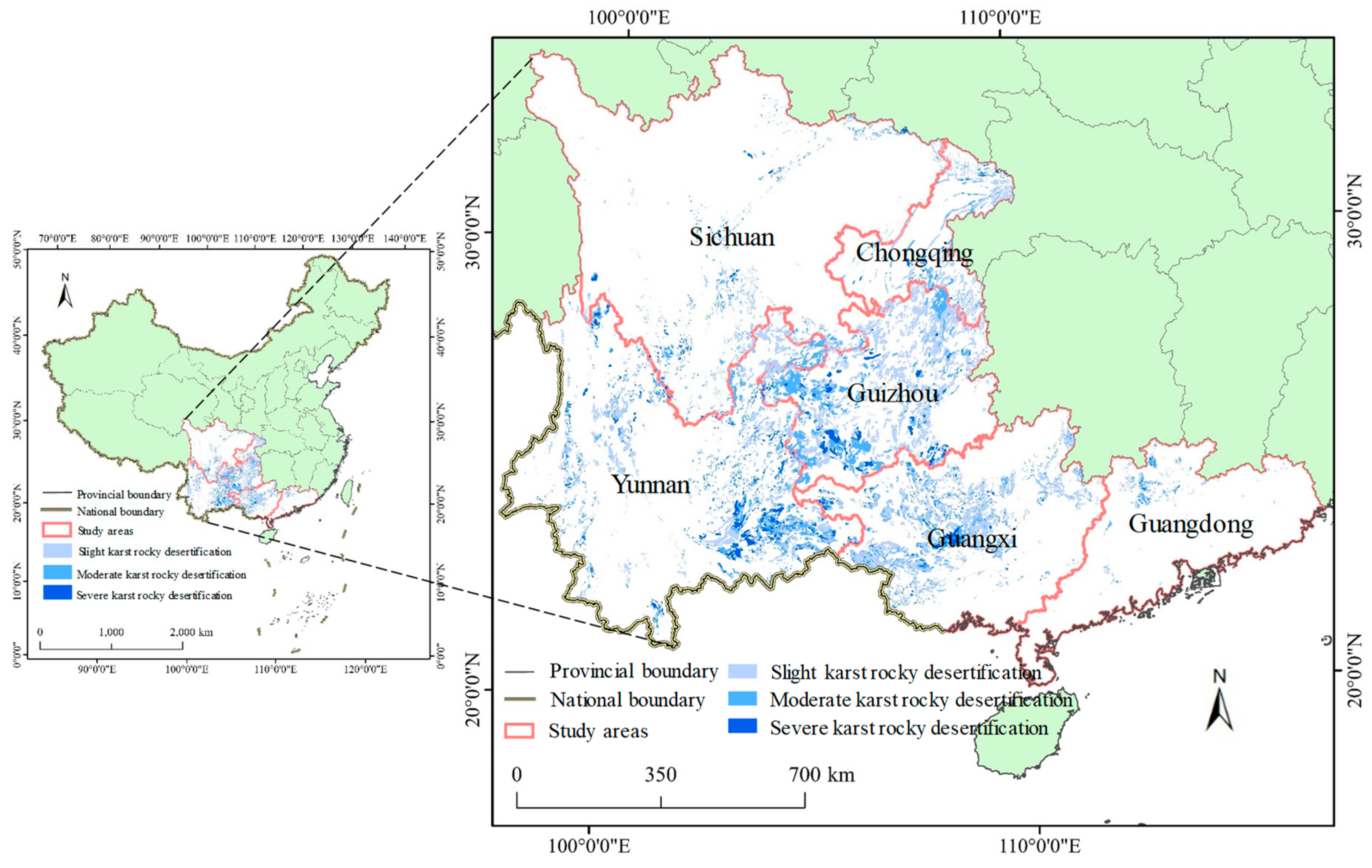
2.1. Study Area
2.2. Data Sources and Preprocessing
2.3. Statistical Analysis
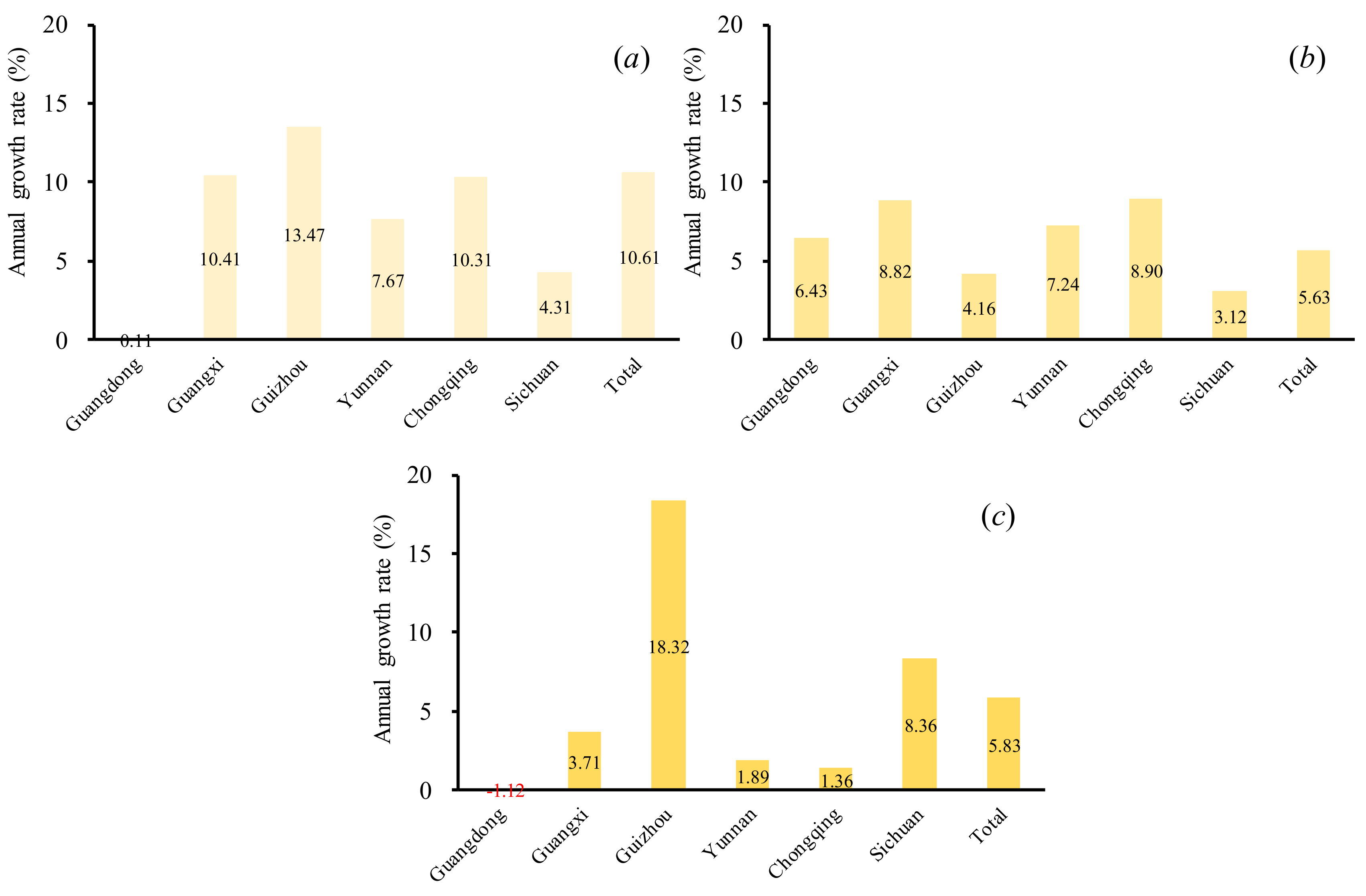
3. Results and Discussion
3.1. Analysis of Spatial Distribution of Karst Rocky Desertification
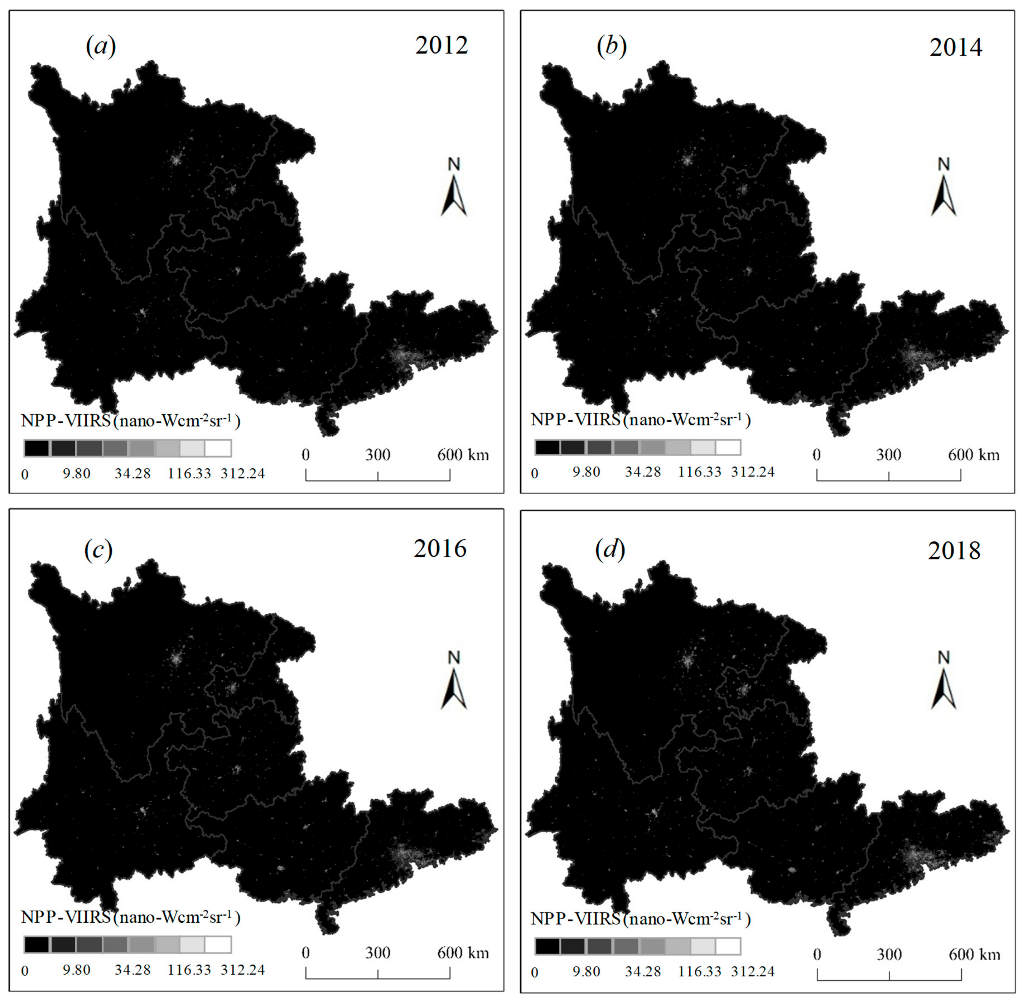
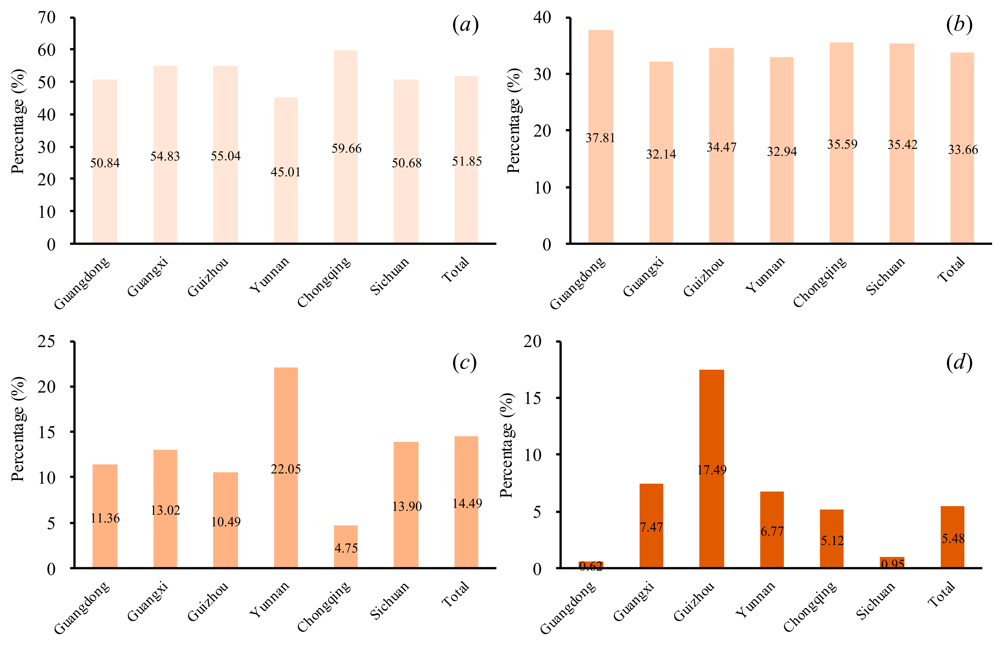
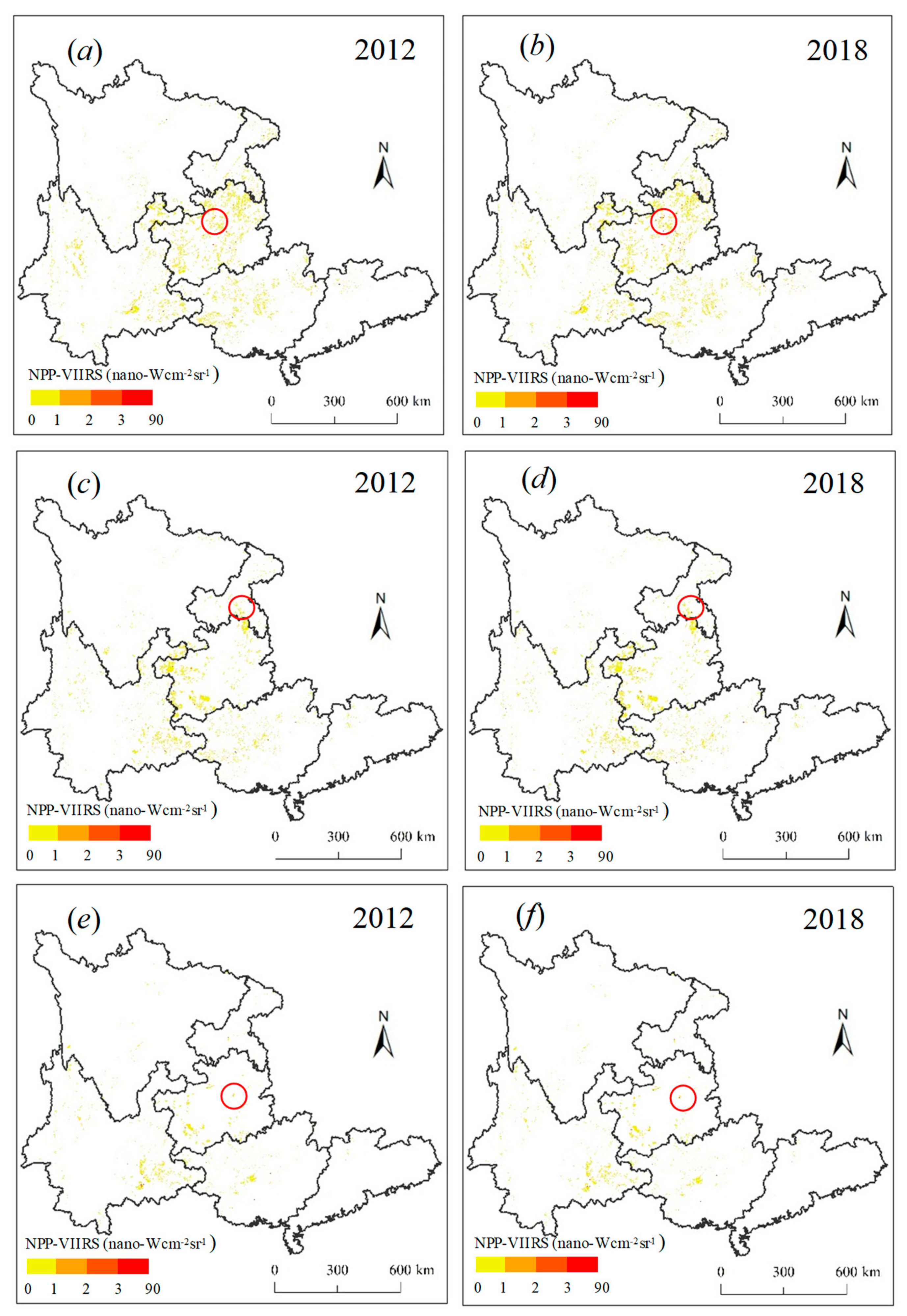
3.2. Analysis of the Nighttime Lights Related to Karst Rocky Desertification
4. Conclusions
Author Contributions
Funding
Conflicts of Interest
References
- Di, X.; Xiao, B.; Dong, H.; Wang, S. Implication of different humic acid fractions in soils under karst rocky desertification. Catena 2019, 174, 308–315. [Google Scholar] [CrossRef]
- Xu, E.; Zhang, H. A spatial simulation model for karst rocky desertification combining top-down and bottom-up approaches. Land Degrad. Dev. 2018, 29, 3390–3404. [Google Scholar] [CrossRef]
- Yang, Q.; Wang, K.; Zhang, C.; Yue, Y.; Tian, R. Spatio-temporal evolution of rocky desertification and its driving forces in karst areas of Northwestern Guangxi, China. Environ. Earth Sci. 2011, 64, 383–393. [Google Scholar] [CrossRef]
- Costa-Cabral, M.C.; Richey, J.E.; Goteti, G.; Lettenmaier, D.P.; Feldkötter, C.; Snidvongs, A. Landscape structure and use, climate, and water movement in the Mekong River Basin. Hydrol. Process. 2010, 22, 1731–1746. [Google Scholar] [CrossRef]
- Febles-González, J.M.; Vega-Carreño, M.B.; Tolón-Becerra, A.; Lastra-Bravo, X. Assessment of soil erosion in karst regions of Havana, Cuba. Land Degrad. Dev. 2012, 23, 465–474. [Google Scholar] [CrossRef]
- Tang, Y.; Han, G. Seasonal variation and quality assessment of the major and trace elements of atmospheric dust in a typical karst city, Southwest China. Int. J. Environ. Res. Public Health 2019, 16, 325. [Google Scholar] [CrossRef]
- Jiang, Z.; Lian, Y.; Qin, X. Rocky desertification in Southwest China: Impacts, causes, and restoration. Earth-Sci. Rev. 2014, 132, 1–12. [Google Scholar] [CrossRef]
- Yan, X.; Cai, Y. Multi-scale anthropogenic driving forces of karst rocky desertification in Southwest China. Land Degrad. Dev. 2015, 26, 193–200. [Google Scholar] [CrossRef]
- Xu, E.; Zhang, H.; Li, M. Mining spatial information to investigate the evolution of karst rocky desertification and its human driving forces in Changshun, China. Sci. Total Environ. 2013, 458, 419–426. [Google Scholar] [CrossRef]
- Zhang, Z.; Zhou, Y.; Wang, S.; Huang, X. Spatial distribution of stony desertification and key influencing factors on different sampling scales in small karst watersheds. Int. J. Environ. Res. Public Health 2018, 15, 743. [Google Scholar] [CrossRef]
- Chen, F.; Shijie, W.; Bai, X.; Fang, L.; Dequan, Z.; Yichao, T.; Guangjie, L.; Li, Q.; Luhua, W.; Cheng, Z. Assessing spatial-temporal evolution processes and driving forces of karst rocky desertification. Geocarto Int. 2019, 1–22. [Google Scholar] [CrossRef]
- Tong, X.; Brandt, M.; Yue, Y.; Horion, S.; Wang, K.; De Keersmaecker, W.; Tian, F.; Schurgers, G.; Xiao, X.; Luo, Y. Increased vegetation growth and carbon stock in China karst via ecological engineering. Nat. Sustain. 2018, 1, 44. [Google Scholar] [CrossRef]
- Wu, X.; Liu, H.; Huang, X.; Zhou, T. Human driving forces: Analysis of rocky desertification in karst region in Guanling County, Guizhou Province. Chin. Geogr. Sci. 2011, 21, 600. [Google Scholar] [CrossRef]
- Shi, K.; Huang, C.; Chen, Y.; Li, L. Remotely sensed nighttime lights reveal increasing human activities in protected areas of China mainland. Remote Sens. Lett. 2018, 9, 468–477. [Google Scholar] [CrossRef]
- Cao, X.; Wang, J.; Chen, J.; Shi, F. Spatialization of electricity consumption of China using saturation-corrected DMSP-OLS data. Int. J. Appl. Earth Obs. Geoinf. 2014, 28, 193–200. [Google Scholar] [CrossRef]
- Li, X.; Ge, L.; Chen, X. Quantifying contribution of land use types to nighttime light using an unmixing model. IEEE Geosci. Remote Sens. Lett. 2014, 11, 1667–1671. [Google Scholar] [CrossRef]
- Li, X.; Ma, R.; Zhang, Q.; Li, D.; Liu, S.; He, T.; Zhao, L. Anisotropic characteristic of artificial light at night–Systematic investigation with VIIRS DNB multi-temporal observations. Remote Sens. Environ. 2019, 233, 111357. [Google Scholar] [CrossRef]
- Shi, K.; Yu, B.; Huang, Y.; Hu, Y.; Yin, B.; Chen, Z.; Chen, L.; Wu, J. Evaluating the ability of NPP-VIIRS nighttime light data to estimate the gross domestic product and the electric power consumption of China at multiple scales: A comparison with DMSP-OLS data. Remote Sens. 2014, 6, 1705–1724. [Google Scholar] [CrossRef]
- Amaral, S.; Câmara, G.; Monteiro, A.M.V.; Quintanilha, J.A.; Elvidge, C.D. Estimating population and energy consumption in Brazilian Amazonia using DMSP night-time satellite data. Comput. Environ. Urban Syst. 2005, 29, 179–195. [Google Scholar] [CrossRef]
- Shi, K.; Chen, Y.; Yu, B.; Xu, T.; Chen, Z.; Liu, R.; Li, L.; Wu, J. Modeling spatiotemporal CO2 (carbon dioxide) emission dynamics in China from DMSP-OLS nighttime stable light data using panel data analysis. Appl. Energy 2016, 168, 523–533. [Google Scholar] [CrossRef]
- Shi, K.; Chen, Y.; Yu, B.; Xu, T.; Yang, C.; Li, L.; Huang, C.; Chen, Z.; Liu, R.; Wu, J. Detecting spatiotemporal dynamics of global electric power consumption using DMSP-OLS nighttime stable light data. Appl. Energy 2016, 184, 450–463. [Google Scholar] [CrossRef]
- Chen, Z.; Yu, B.; Hu, Y.; Huang, C.; Shi, K.; Wu, J. Estimating house vacancy rate in metropolitan areas using NPP-VIIRS nighttime light composite data. IEEE J. Sel. Top. Appl. Earth Obs. Remote Sens. 2015, 8, 2188–2197. [Google Scholar] [CrossRef]
- Shi, K.; Huang, C.; Yu, B.; Yin, B.; Huang, Y.; Wu, J. Evaluation of NPP-VIIRS night-time light composite data for extracting built-up urban areas. Remote Sens. Lett. 2014, 5, 358–366. [Google Scholar] [CrossRef]
- Shi, K.; Chen, Y.; Yu, B.; Xu, T.; Li, L.; Huang, C.; Liu, R.; Chen, Z.; Wu, J. Urban expansion and agricultural land loss in China: A multiscale perspective. Sustainability 2016, 8, 790. [Google Scholar] [CrossRef]
- China Statistical Yearbook; China Statistical Press: Beijing, China, 2018.
- China Statistical Yearbook; China Statistical Press: Beijing, China, 2001.
- Zhang, G.; Li, L.; Jiang, Y.; Shen, X.; Li, D. On-orbit relative radiometric calibration of the night-time sensor of the Luojia1-01 satellite. Sensors 2018, 18, 4225. [Google Scholar] [CrossRef]
- Li, X.; Li, X.; Li, D.; He, X.; Jendryke, M. A preliminary investigation of Luojia-1 night-time light imagery. Remote Sens. Lett. 2019, 10, 526–535. [Google Scholar] [CrossRef]
- Shi, K.; Yu, B.; Hu, Y.; Huang, C.; Chen, Y.; Huang, Y.; Chen, Z.; Wu, J. Modeling and mapping total freight traffic in China using NPP-VIIRS nighttime light composite data. GISci. Remote Sens. 2015, 52, 274–289. [Google Scholar] [CrossRef]
- Shi, K.; Li, Y.; Chen, Y.; Li, L.; Huang, C. How does the urban form-PM2.5 concentration relationship change seasonally in Chinese cities? A comparative analysis between national and urban agglomeration scales. J. Clean. Prod. 2019, 239, 118088. [Google Scholar] [CrossRef]
- Wang, L.; Wang, S.; Yi, Z.; Liu, W.; Hou, Y.; Zhu, J.; Wang, F. Mapping population density in China between 1990 and 2010 using remote sensing. Remote Sens. Environ. 2018, 210, 269–281. [Google Scholar] [CrossRef]
- Jiang, Y.; Li, L.; Groves, C.; Yuan, D.; Kambesis, P. Relationships between rocky desertification and spatial pattern of land use in typical karst area, Southwest China. Environ. Earth Sci. 2009, 59, 881. [Google Scholar] [CrossRef]
- Wang, Z.; Jiang, Y.; Zhang, Y.; Duan, S.; Liu, J.; Zeng, Z.; Zeng, S. Spatial distribution and driving factors of karst rocky desertification based on GIS and geodetectors. Acta Geogr. Sin. 2019, 74, 1025–1039. (In Chinese) [Google Scholar]
- He, C.; Li, J.; Zhang, X.; Liu, Z.; Zhang, D. Will rapid urban expansion in the drylands of northern China continue: A scenario analysis based on the land use scenario dynamics-urban model and the shared socioeconomic pathways. J. Clean. Prod. 2017, 165, 57–69. [Google Scholar] [CrossRef]


| DD | Name | Year | Mean | ||||||
|---|---|---|---|---|---|---|---|---|---|
| 2012 | 2013 | 2014 | 2015 | 2016 | 2017 | 2018 | |||
| (nano-Wcm−2sr−1) | |||||||||
| L | Guangdong | 739 | 721 | 820 | 642 | 573 | 709 | 744 | 707 |
| Guangxi | 4554 | 5051 | 5037 | 5678 | 5991 | 7518 | 8253 | 6012 | |
| Guizhou | 6369 | 8761 | 8566 | 7826 | 10,175 | 14,398 | 13,591 | 9955 | |
| Yunnan | 3530 | 4031 | 3458 | 3922 | 3375 | 5160 | 5498 | 4139 | |
| Chongqing | 784 | 985 | 809 | 770 | 1085 | 1542 | 1413 | 1055 | |
| Sichuan | 456 | 574 | 484 | 442 | 415 | 523 | 588 | 497 | |
| Total | 16,433 | 20,123 | 19,174 | 19,281 | 21,613 | 29,850 | 30,087 | 22,366 | |
| M | Guangdong | 231 | 281 | 239 | 218 | 204 | 284 | 336 | 256 |
| Guangxi | 2604 | 2657 | 2758 | 2997 | 3219 | 4023 | 4322 | 3226 | |
| Guizhou | 4350 | 4725 | 4659 | 4494 | 5064 | 6,025 | 5556 | 4982 | |
| Yunnan | 3860 | 4294 | 4083 | 4420 | 4037 | 5371 | 5873 | 4563 | |
| Chongqing | 433 | 568 | 424 | 465 | 490 | 731 | 723 | 548 | |
| Sichuan | 469 | 793 | 474 | 393 | 378 | 461 | 565 | 505 | |
| Total | 13,960 | 15,332 | 14,652 | 15,002 | 15,408 | 18,912 | 19,393 | 16,094 | |
| S | Guangdong | 253 | 246 | 224 | 189 | 163 | 211 | 237 | 218 |
| Guangxi | 1361 | 1580 | 1445 | 1281 | 1474 | 1756 | 1694 | 1513 | |
| Guizhou | 1201 | 1688 | 1510 | 1798 | 2938 | 3859 | 3295 | 2327 | |
| Yunnan | 4142 | 4082 | 3739 | 3756 | 3262 | 4211 | 4634 | 3975 | |
| Chongqing | 284 | 276 | 231 | 207 | 279 | 322 | 308 | 272 | |
| Sichuan | 31 | 38 | 35 | 34 | 38 | 51 | 50 | 40 | |
| Total | 7273 | 7911 | 7183 | 7265 | 8155 | 10,409 | 10,218 | 8345 | |
| DD | Name | Year | Mean | ||||||
|---|---|---|---|---|---|---|---|---|---|
| 2012 | 2013 | 2014 | 2015 | 2016 | 2017 | 2018 | |||
| (nano-Wcm−2sr−1) | |||||||||
| L | Guangdong | 0.33 | 0.32 | 0.37 | 0.29 | 0.26 | 0.32 | 0.34 | 0.32 |
| Guangxi | 0.12 | 0.13 | 0.13 | 0.15 | 0.15 | 0.19 | 0.21 | 0.15 | |
| Guizhou | 0.09 | 0.13 | 0.13 | 0.12 | 0.15 | 0.21 | 0.20 | 0.15 | |
| Yunnan | 0.07 | 0.08 | 0.07 | 0.08 | 0.07 | 0.11 | 0.11 | 0.08 | |
| Chongqing | 0.08 | 0.10 | 0.08 | 0.08 | 0.11 | 0.15 | 0.14 | 0.11 | |
| Sichuan | 0.05 | 0.06 | 0.05 | 0.05 | 0.04 | 0.05 | 0.06 | 0.05 | |
| Total | 0.09 | 0.11 | 0.11 | 0.11 | 0.12 | 0.17 | 0.17 | 0.13 | |
| M | Guangdong | 0.14 | 0.17 | 0.15 | 0.13 | 0.13 | 0.17 | 0.21 | 0.16 |
| Guangxi | 0.11 | 0.12 | 0.12 | 0.13 | 0.14 | 0.18 | 0.19 | 0.14 | |
| Guizhou | 0.10 | 0.11 | 0.11 | 0.10 | 0.12 | 0.14 | 0.13 | 0.12 | |
| Yunnan | 0.11 | 0.13 | 0.12 | 0.13 | 0.12 | 0.16 | 0.17 | 0.13 | |
| Chongqing | 0.07 | 0.10 | 0.07 | 0.08 | 0.08 | 0.12 | 0.12 | 0.09 | |
| Sichuan | 0.07 | 0.12 | 0.07 | 0.06 | 0.06 | 0.07 | 0.09 | 0.08 | |
| Total | 0.12 | 0.13 | 0.13 | 0.13 | 0.14 | 0.17 | 0.17 | 0.14 | |
| S | Guangdong | 0.32 | 0.31 | 0.28 | 0.24 | 0.20 | 0.26 | 0.30 | 0.27 |
| Guangxi | 0.14 | 0.16 | 0.15 | 0.13 | 0.15 | 0.18 | 0.17 | 0.15 | |
| Guizhou | 0.09 | 0.13 | 0.12 | 0.14 | 0.23 | 0.30 | 0.26 | 0.18 | |
| Yunnan | 0.18 | 0.18 | 0.16 | 0.16 | 0.14 | 0.18 | 0.20 | 0.17 | |
| Chongqing | 0.36 | 0.35 | 0.29 | 0.26 | 0.36 | 0.41 | 0.39 | 0.35 | |
| Sichuan | 0.01 | 0.01 | 0.01 | 0.01 | 0.01 | 0.02 | 0.02 | 0.01 | |
| Total | 0.15 | 0.16 | 0.14 | 0.15 | 0.16 | 0.21 | 0.20 | 0.17 | |
© 2019 by the authors. Licensee MDPI, Basel, Switzerland. This article is an open access article distributed under the terms and conditions of the Creative Commons Attribution (CC BY) license (http://creativecommons.org/licenses/by/4.0/).
Share and Cite
Shi, K.; Yang, Q.; Li, Y. Are Karst Rocky Desertification Areas Affected by Increasing Human Activity in Southern China? An Empirical Analysis from Nighttime Light Data. Int. J. Environ. Res. Public Health 2019, 16, 4175. https://doi.org/10.3390/ijerph16214175
Shi K, Yang Q, Li Y. Are Karst Rocky Desertification Areas Affected by Increasing Human Activity in Southern China? An Empirical Analysis from Nighttime Light Data. International Journal of Environmental Research and Public Health. 2019; 16(21):4175. https://doi.org/10.3390/ijerph16214175
Chicago/Turabian StyleShi, Kaifang, Qingyuan Yang, and Yuanqing Li. 2019. "Are Karst Rocky Desertification Areas Affected by Increasing Human Activity in Southern China? An Empirical Analysis from Nighttime Light Data" International Journal of Environmental Research and Public Health 16, no. 21: 4175. https://doi.org/10.3390/ijerph16214175
APA StyleShi, K., Yang, Q., & Li, Y. (2019). Are Karst Rocky Desertification Areas Affected by Increasing Human Activity in Southern China? An Empirical Analysis from Nighttime Light Data. International Journal of Environmental Research and Public Health, 16(21), 4175. https://doi.org/10.3390/ijerph16214175