Assessment of Landscape Ecological Health: A Case Study of a Mining City in a Semi-Arid Steppe
Abstract
:1. Introduction
2. Materials and Methods
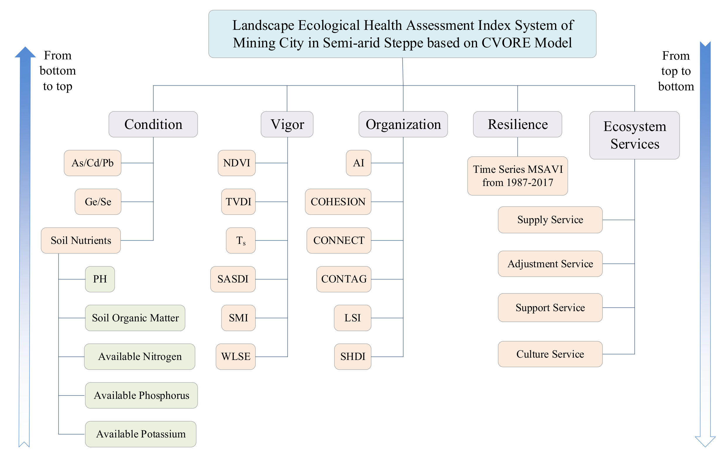
2.1. Assessment Index System for Mining City Landscape Ecological Health in Semi-Arid Steppe
2.1.1. Indexes Selection for Condition
2.1.2. Indexes Selection for Vigor
2.1.3. Indexes Selection for Organization
2.1.4. Indexes Selection for Resilience
2.1.5. Indexes Selection for Ecosystem Services
2.2. Study Area
2.3. Data Source and Processing
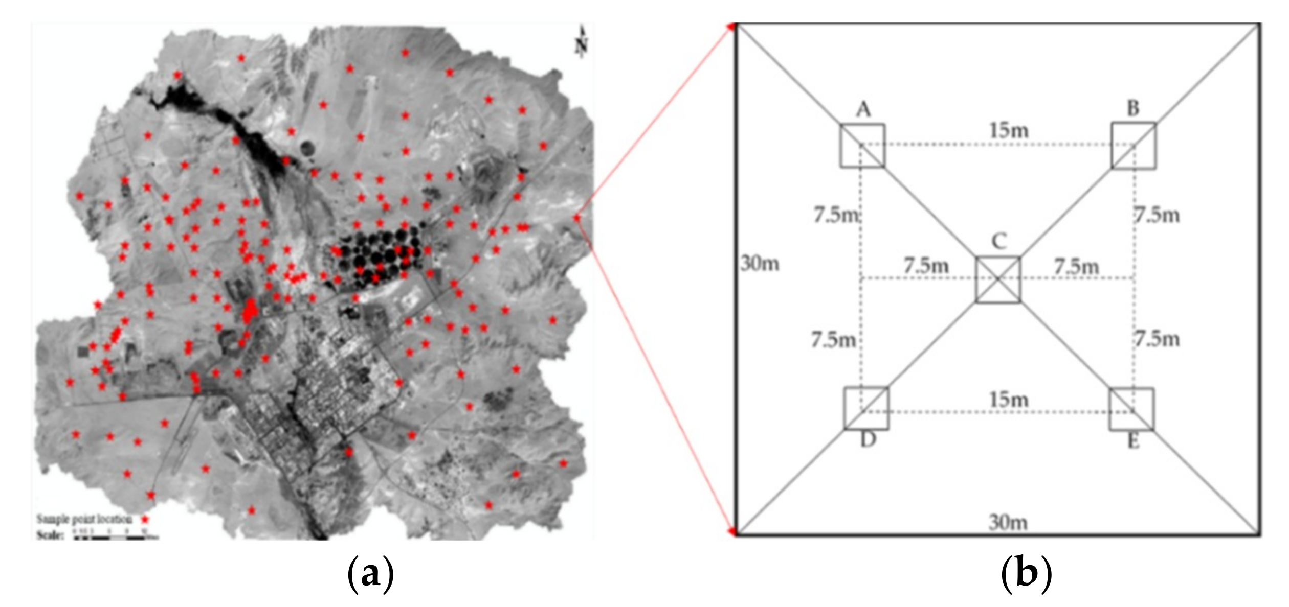
2.4. Sampling, Testing and Spatial Modeling of Soil Samples
2.5. Determination of Indicator Weights
3. Results
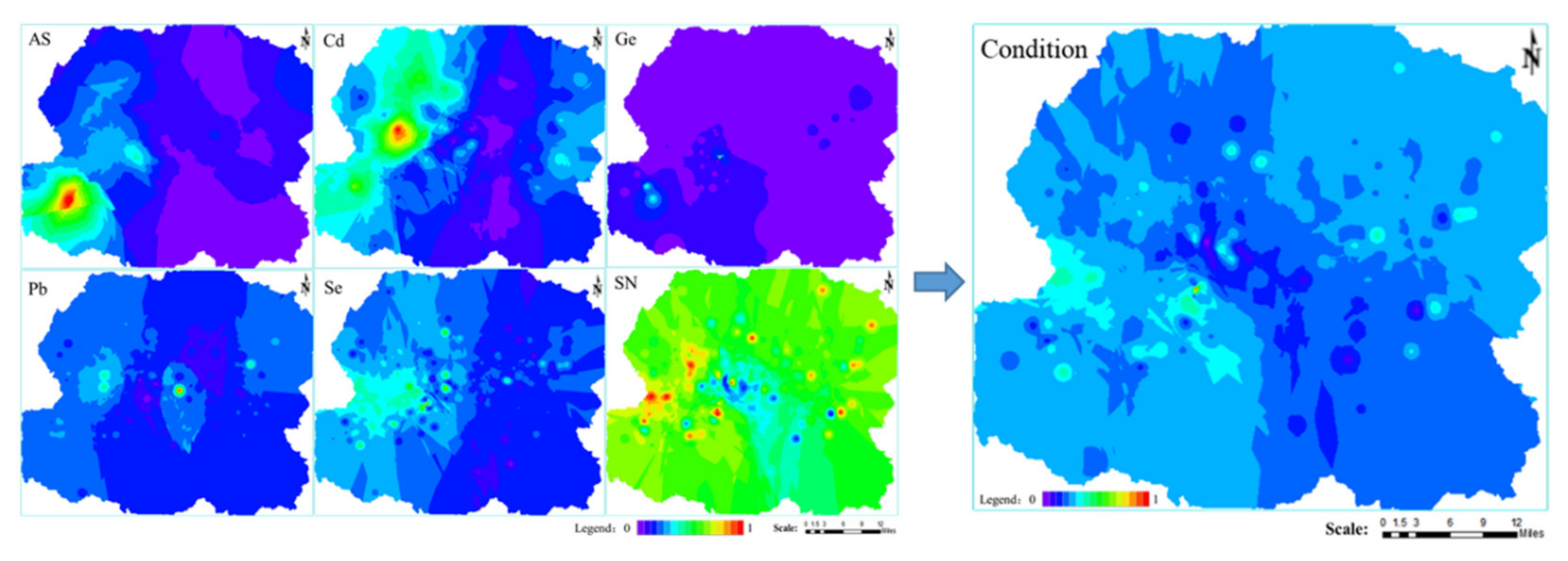
3.1. Condition
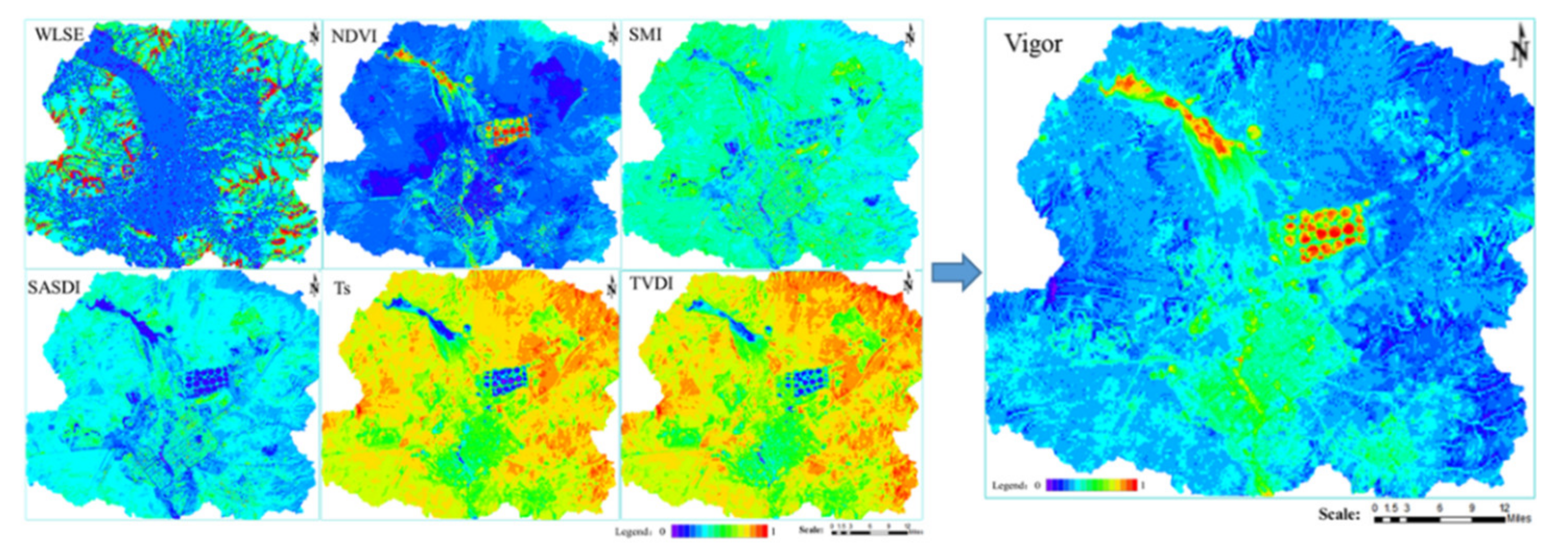
3.2. Vigor
3.3. Organization
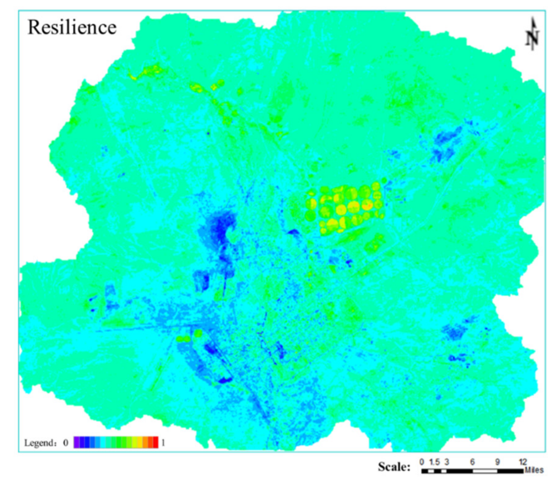
3.4. Resilience
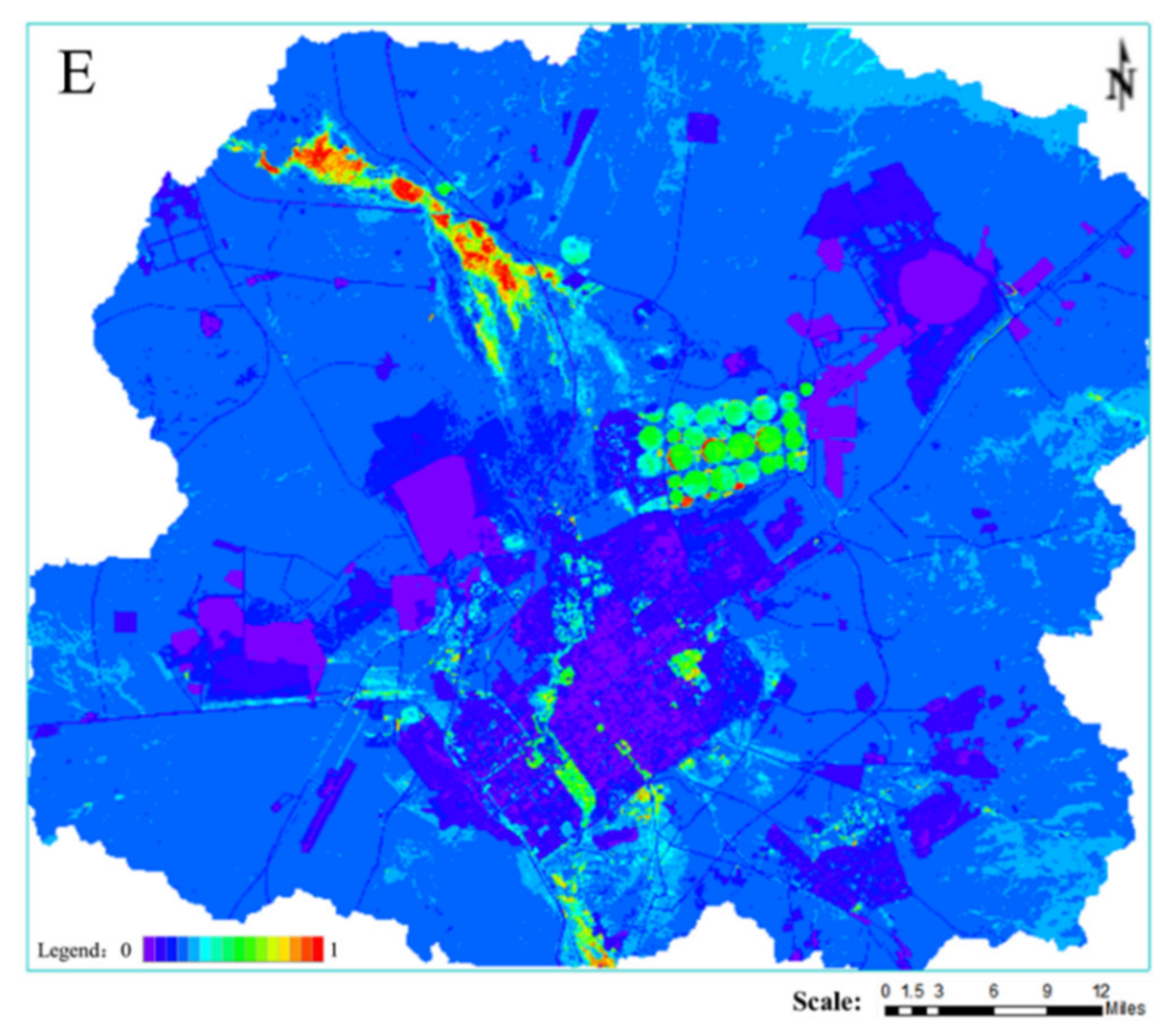
3.5. Ecosystem Services
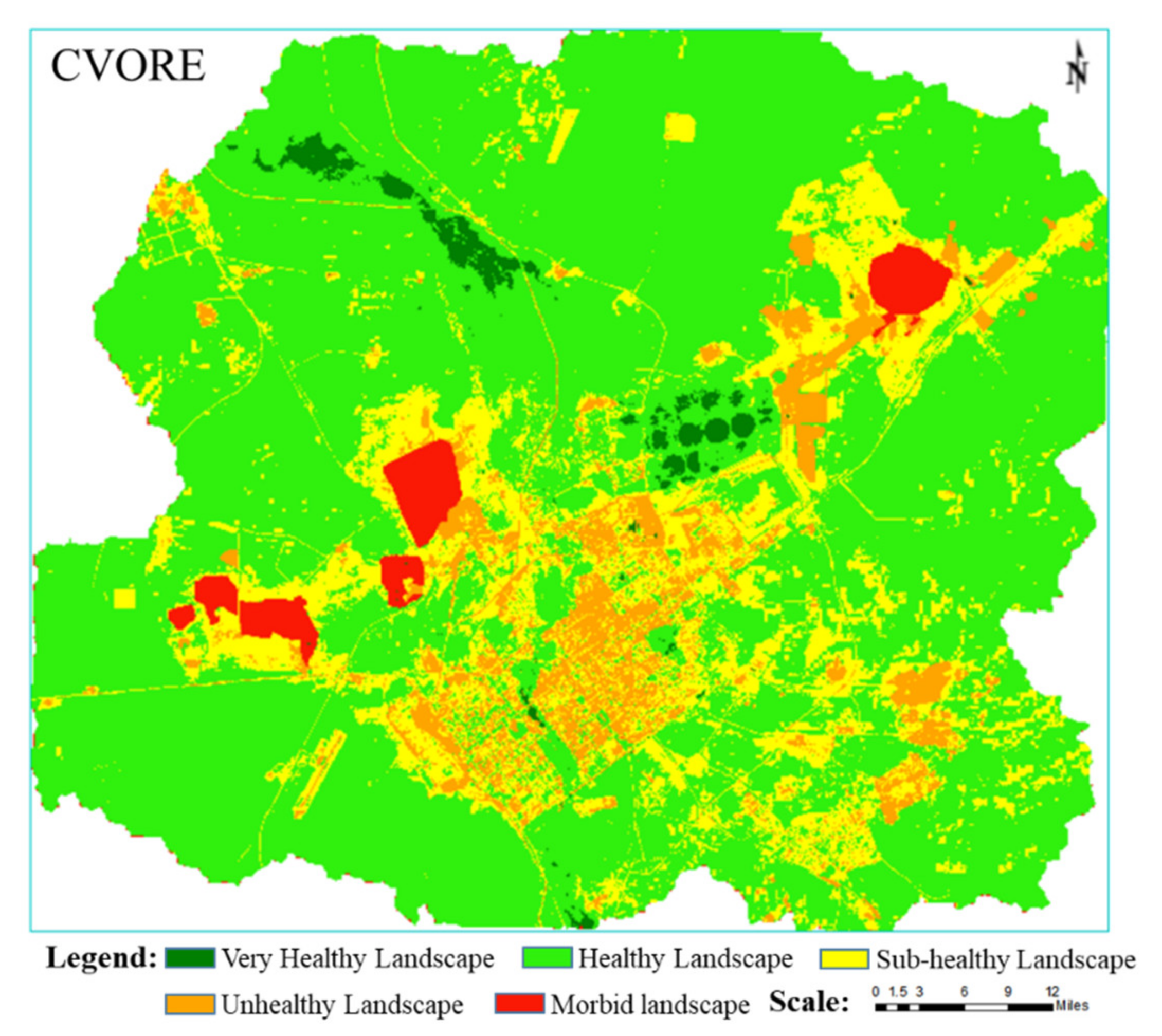
3.6. Landscape Ecological Health Assessment Result of the Mining City
4. Discussion
4.1. Effects of Mining and Water Landscape on Landscape Ecological Health of Grassland
4.2. Advantages of the CVORE Comprehensive Index Model
4.3. Research Prospects of Landscape Ecological Health in Mining Cities
- (1)
- Selection of indexes. The indicators used in this study are more focused on remote sensing images, which are easily and dynamically captured in real time. However, the LEH of mining cities should also include other aspects like animal communities, plant communities, microbial communities, hydrology, geology, and atmosphere. Researchers should monitor these ecological factors over a long time period and observe their dynamic changes throughout the life cycle of mining, as well as the relationship between mining and these ecological factors. At the same time, researchers should also investigate the dynamic changes of human health, social stability, public health, economic structure, and of other factors during the whole life cycle of mining, as well as the relationship between mining and these socio-economic factors.
- (2)
- Research on influence mechanism(s). This study is based on data covering only the year 2017. Further research should investigate the impact mechanism of mining exploitation on LEH, the driving forces of LEH evolution in mining cities, the impact of landscape processes on LEH, and the impact of landscape pattern on LEH, through a time series LEH assessment.
- (3)
- Scale problem. The LEH assessment of mining cities should focus on three core scales: mining city, mining groups, and mining areas. At the scale of the mining city, it should include at least grassland landscapes, town landscapes, mining landscapes, and other spatial scales with clear differences. Although the results of LEH assessment at different spatial scales are closely related, the non-deductibility of scale determines that LEH at larger scales cannot be linearly reduced to smaller scales, nor is it a simple accumulation of ecological health at smaller scales. Therefore, the LEH assessment of mining city should be performed at multiple scales. At the same time, although the research objects of LEH at different scales have different emphasis, they are not completely separated from each other and are closely related. The comprehensive study of the coordination and the organic integration of LEH at multiple scales, and the ways and methods of transformation among different scales (i.e., multi-scale synthesis and scale conversion of evaluation results), are the key scientific issues of LEH comprehensive research in large mining city [57,58].
4.4. Suggestions on Landscape Ecological Restoration for Mining Cities in Semi-Arid Steppe
- (1)
- Mining city scale. Coal exploitation has affected the sustainable and healthy development of steppes. Due to the excavation, occupied, and piled up areas, healthy landscape patches are reduced, the landscape patches are fragmented, the landscape connectivity decreases, the dimension of habitat patches is reduced and gradually islands form. This in turn seriously hinders the proliferation and circulation of species, while at the same time interfering with the landscape’s own regulatory capacity, and resulting in the reduction of local biodiversity and ecosystem services. Through simulating and controlling the process of WLSE and the biogeochemical cycle, the objectives and standards of landscape ecological optimization were established. Moreover, the spatial and quantitative distribution and connectivity of landscape components were optimized by low-impact development and the development of a network of green infrastructure. In this way, it was possible to maintain the regional LEH within the best possible pattern. As shown in Figure 10, ecological corridors can be constructed to increase landscape connectivity in areas with severely fragmented landscape health patches (as in the southeastern side of the study area), thus increasing the selection of corridors for species migration and the possibility of material and energy flows. In addition, the diseased, unhealthy, and sub-healthy landscapes caused by the presence of the mining area, the city, and the road have been linked together. For this reason, it is necessary to set up landscape isolation zones between the city and the mining area. The existing windbreak forest can be used as the core, while shrubs with a long growth period and a strong ability to suppress wind and dust can be selected to transform the existing windbreak belt. On the one hand, the healthy landscape forms a network; on the other hand, it blocks the unhealthy landscape and the dust.
- (2)
- Mining group scale. Steppe mining cities involve the large-scale continuous mining of multiple mines for a long period of time. The restoration of landscape ecology must be based on the understanding of the comprehensive impact of mine exploitation on the LEH of steppe mining city, and on the control of the entire situation from three perspectives: space, time, and ecological environment. First, at the spatial level, a large number of permanent excavation sites, mining pits, internal dumping sites, and other industrial and mining landscape units are optimized to the spatial pattern and landform morphology. At the same time, new landscapes such as ecological green belts and temporary wetland units are introduced, improving and controlling WLSE, surface hydrological process, and material cycle and pollutant diffusion in the mining city. Second, in the time dimension, the life cycle of mining should be understood. This means that the simulation, analysis, and design of mine landscape ecological restoration should be combined with mining planning to formulate the whole life cycle of the landscape ecological restoration plan. In this way, it is possible to avoid the discontinuity of the landscape ecological restoration plan at each stage. Third, in order to protect the integrity and continuity of regional landscape ecology, it is necessary to consider not only the soil reconstruction, land renovation, and vegetation construction of mine landscape units such as the dump, but also the integration of the landscape with the surrounding natural landforms. In this way, the connectivity between the dump and the surface water hydrology in surrounding areas will be improved.
- (3)
- Mining scale. Open-pit mining damages the original surface, resulting in the deterioration of LEH and in the formation of large-scale artificial padding landscapes. Soil compaction is caused by heavy machinery operations; soil and vegetation functions are seriously impaired and, under extreme weather conditions, rock and WLSE in mining areas is intensified. Traditional reclamation methods often form a flat horse surface; the water system is not mature enough and can be easily eroded by natural concentrated rainfall; finally, erosion is more serious under extreme climate conditions. Moreover, it is difficult to maintain biodiversity in a single geomorphic environment, which limits the rapid restoration of the ecological environment to resist desertification and erosion. Therefore, it is necessary to maintain the stability and ecological sustainability of the geological environment of the internal/external dump and of the mining pit in the mining area, to control their impact on the surrounding landscape matrix or patch habitats, and to enhance their integration with the surrounding grassland natural landform and hydrology through the life cycle near-natural design. The restored landscape should be coordinated with its surroundings; the slope surface should be kept stable for a long time; the soil and water conservation should be maximized; and the original ecological status should be restored for soil microorganisms, vegetation, and animals. Without additional soil and water conservation measures, no runoff will occur on the slopes. The winding drainage channels and the continuous catchment pits allow all the rainwater to infiltrate and accumulate in the watershed. In this way, the restored ecosystem can maintain itself and gradually enhance its function.
5. Conclusions
Author Contributions
Funding
Conflicts of Interest
References
- Wen, L.; Dong, S.; Li, Y.; Wang, X.; Li, X. The impact of land degradation on the C pools in alpine grasslands of the Qinghai-Tibet Plateau. Plant Soil 2013, 368, 329–340. [Google Scholar] [CrossRef]
- Li, X.; Jia, X.H.; Dong, G.R. Influence of desertification on vegetation pattern variations in the cold semi-arid steppes of Qinghai-Tibet Plateau, North-west China. J. Arid Environ. 2006, 64, 505–522. [Google Scholar] [CrossRef]
- Jian, P.; Wang, Y.; Wu, J.; Hong, S.; Pan, Y. Research progress on evaluation frameworks of regional ecological sustainability. Chin. Geogr. Sci. 2011, 21, 496–510. [Google Scholar]
- Zhang, J.; Fu, M.; Hassani, F.P.; Hui, Z.; Geng, Y.; Bai, Z. Land use-based landscape planning and restoration in mine closure areas. Environ. Manag. 2011, 47, 739–750. [Google Scholar] [CrossRef] [PubMed]
- Liu, X.; Meng, X. Evaluation and empirical research on the energy efficiency of 20 mining cities in Eastern and Central China. Int. J. Min. Sci. Technol. 2018, 28, 525–531. [Google Scholar] [CrossRef]
- Fan, Y.; Lu, Z.; Cheng, J.; Zhou, Z.; Wu, G. Major ecological and environmental problems and the ecological reconstruction technologies of the coal mining areas in China. Acta Ecol. Sin. 2003, 23, 2144–2152. [Google Scholar]
- Lavigne, F.; Gunnell, Y. Land cover change and abrupt environmental impacts on Javan volcanoes, Indonesia: A long-term perspective on recent events. Reg. Environ. Chang. 2006, 6, 86–100. [Google Scholar] [CrossRef]
- Niedertscheider, M.; Gingrich, S.; Erb, K.H. Changes in land use in South Africa between 1961 and 2006: An integrated socio-ecological analysis based on the human appropriation of net primary production framework. Reg. Environ. Chang. 2012, 12, 715–727. [Google Scholar] [CrossRef]
- Nainggolan, D.; Reed, M.S.; Cebollero, E.D.; Hubacek, K. Farmer typology, future scenarios and the implications for ecosystem service provision: A case study from south-eastern Spain. Reg. Environ. Chang. 2013, 13, 601–614. [Google Scholar] [CrossRef]
- Torres, R.; Gasparri, N.I.; Blendinger, P.G.; Grau, H.R. Land-use and land-cover effects on regional biodiversity distribution in a subtropical dry forest: A hierarchical integrative multi-taxa study. Reg. Environ. Chang. 2014, 14, 1549–1561. [Google Scholar] [CrossRef]
- Wolf, K.L.; Brinkley, W.; Romolini, M. Environmental stewardship footprint research: Linking human agency and ecosystem health in the Puget Sound region. Urban Ecosyst. 2013, 16, 13–32. [Google Scholar] [CrossRef]
- Rabinowitz, P.; Conti, L. Links Among Human Health, Animal Health, and Ecosystem Health. Annu. Rev. Public Health 2013, 34, 189–204. [Google Scholar] [CrossRef] [PubMed]
- Rapport, D.J.; Maffi, L. Eco-cultural health, global health, and sustainability. Ecol. Res. 2011, 26, 1039–1049. [Google Scholar] [CrossRef]
- Rapport, D.J.; Thorpe, C.; Regier, H.A. Ecosystem Medicine. Bull. Ecol. Soc. Am. 1979, 60, 180–182. [Google Scholar]
- Lee, B.J. An ecological comparison of the McHarg method with other planning initiatives in the Great Lakes Basin. Landsc. Plann. 1982, 9, 147–169. [Google Scholar] [CrossRef]
- Ferguson, B.K. The Concept of Landscape Health. J. Environ. Manag. 1994, 40, 129–137. [Google Scholar] [CrossRef]
- Fu, B.; Ma, K. Principles and Applications of Landscape Ecology; Science Press: Beijing, China, 2011. [Google Scholar]
- Yu, C.; Song, D. A review on the concept, characteristic and assessment of landscape health. Chin. J. Appl. Ecol. 2002, 13, 1511. [Google Scholar]
- Wang, G. Theory and Empirical Study of Ecosystem Health Assessment in the Mining Area; Economic Science Press: Beijing, China, 2006. [Google Scholar]
- Yu, W.; Liu, Y.; Lin, M.; Fang, F.; Xiao, R. Ecosystem Health Assessment of Mining Cities Based on Landscape Pattern. In Proceedings of the International Archives of the Photogrammetry, Remote Sensing and Spatial Information Sciences, Wuhan, China, 18–22 September 2017; Volume XLII-2/W7. [Google Scholar]
- Li, H. Ecological Health Assessment of Mining Area Based on Matter Element Analysis Method; Shandong Agricultural University: Tai’an, China, 2010. [Google Scholar]
- Yang, X. Extension Assessment of Ecosystem Health in the Mining Area; Taiyuan University of Technology: Taiyuan, China, 2011. [Google Scholar]
- Wang, Z.; Tang, L.; Qiu, Q.; Chen, H.; Wu, T.; Shao, G. Assessment of Regional Ecosystem Health—A Case Study of the Golden Triangle of Southern Fujian Province, China. Int. J. Environ. Res. Public Health 2018, 15, 802. [Google Scholar] [CrossRef] [PubMed]
- Costanza, R.; Haskell, B.D. Ecosystem Health: New Goals for Environmental Management; Island Press: Washington, DC, USA, 1992. [Google Scholar]
- Washington-Allen, R.A.; Council, N. Rangeland Health: New Methods to Classify, Inventory, and Monitor Rangelands; National Academy Press: Washington, DC, USA, 1994. [Google Scholar]
- Ren, J.; Zhi, N.; Hao, D. The three major interfaces within pratacultural system. Acta Pratacult. Sin. 2000, 9, 1–8. [Google Scholar]
- Rapport, D.J. Ecosystem services and management options as blanket indicators of ecosystem health. J. Aquat. Ecosyst. Health 1995, 4, 97–105. [Google Scholar] [CrossRef]
- Costanza, R. Ecosystem health and ecological engineering. Ecol. Eng. 2012, 45, 24–29. [Google Scholar] [CrossRef]
- Rapport, D.J.; Costanza, R.; Mcmichael, A.J. Assessing ecosystem health. Trends Ecol. Evol. 1999, 13, 397–402. [Google Scholar] [CrossRef]
- Jian, P.; Liu, Y.; Wu, J.; Lv, H.; Hu, X. Linking ecosystem services and landscape patterns to assess urban ecosystem health: A case study in Shenzhen City, China. Landsc. Urban Plan. 2015, 143, 56–68. [Google Scholar]
- Peng, J.; Liu, Y.; Li, T.; Wu, J. Regional ecosystem health response to rural land use change: A case study in Lijiang City, China. Ecol. Indic. 2017, 72, 399–410. [Google Scholar] [CrossRef]
- Hou, F.; Guang, L.I.; Chang, S. Physiological indices of grazed grassland under health management. Chin. J. Appl. Ecol. 2002, 13, 1049–1053. [Google Scholar]
- Su, W.W.; He, Z.-S. Review of research into heavy metal pollution in mining and related health effect. Mod. Prev. Med. 2009, 4229–4230, 4232. [Google Scholar]
- Phillips, L.B.; Hansen, A.J.; Flather, C.H. Evaluating the species energy relationship with the newest measures of ecosystem energy: NDVI versus MODIS primary production. Remote Sens. Environ. 2008, 112, 3538–3549. [Google Scholar] [CrossRef]
- Bodlák, L.; Křováková, K.; Nedbal, V.; Pechar, L. Assessment of landscape functionality changes as one aspect of reclamation quality–The case of Velká podkrušnohorská dump, Czech Republic. Ecol. Eng. 2012, 43, 19–25. [Google Scholar] [CrossRef]
- He, B.J.; Zhao, Z.Q.; Shen, L.D.; Wang, H.B.; Li, L.G. An approach to examining performances of cool/hot sources in mitigating/enhancing land surface temperature under different temperature backgrounds based on Landsat 8 image. Sustain. Cities Soc. 2019, 44, 416–427. [Google Scholar] [CrossRef]
- Zhao, X.Q.; He, B.J.; Li, L.-G.; Wang, H.-B.; Darko, A. Profile and concentric zonal analysis of relationships between land use/land cover and land surface temperature: Case study of Shenyang, China. Energy Build. 2017, 155, 282–295. [Google Scholar] [CrossRef]
- Sandholt, I.; Rasmussen, K.; Andersen, J. A simple interpretation of the surface temperature/vegetation index space for assessment of surface moisture status. Remote Sens. Environ. 2002, 79, 213–224. [Google Scholar] [CrossRef]
- Qin, Z.; Zhang, M.; Karnieli, A.; Berliner, P. Mono-window Algorithm for Retrieving Land Surface Temperature from Landsat TM6 data. Acta Geogr. Sin. 2001, 56, 456–466. [Google Scholar]
- Zhang, Y.; Xiang, N.; Feng, Z. SI-Albedo space-based remote sensing synthesis index models for monitoring of soil salinization. Acta Pedol. Sin. 2009, 46, 698–703. [Google Scholar]
- Wu, Z.; Bian, Z.; Huang, J.; Zhang, Y. Study of the Desertification Index Based on the Albedo-MSAVI Feature Space for Semi-arid Steppe Region. Environ. Earth Sci. 2019. [Google Scholar] [CrossRef]
- Zeng, H.; Ding, S. Landscape Ecology; Higher Education Press: Beijing, China, 2017. [Google Scholar]
- Peterson, G.D. Contagious Disturbance, Ecological Memory, and the Emergence of Landscape Pattern. Ecosystems 2002, 5, 329–338. [Google Scholar] [CrossRef]
- Zheng, X. Landscape Pattern Spatial Analysis Technology and Its Application; Science Press: Beijing, China, 2010. [Google Scholar]
- López, D.R.; Brizuela, M.A.; Willems, P.; Aguiar, M.R.; Siffredi, G.; Bran, D. Linking ecosystem resistance, resilience, and stability in steppes of North Patagonia. Ecol. Indic. 2013, 24, 1–11. [Google Scholar] [CrossRef]
- Qi, J.; Chehbouni, A.; Huete, A.R.; Kerr, Y.H.; Sorooshian, S.S. A modified soil adjusted vegetation index. Remote Sens. Envrion. 1994, 48, 119–126. [Google Scholar] [CrossRef]
- Li, M.M.; Wu, B.; Yan, C.Z. Beijing, Estimation of Vegetation Fraction in the Upper Basin of Miyun Reservoir by Remote Sensing. Resour. Sci. 2004, 26, 153–159. [Google Scholar]
- Costanza, R.; D’Arge, R.; Naeem, S.; O’Neil, R.V.; Paruelo, J.; Raskin, R.G.; Van Sutton, P. The value of the world’s ecosystem services and natural capital. Nature 1999, 387, 253–260. [Google Scholar] [CrossRef]
- Xie, G.D.; Zhang, Y.L.; Chun Xia, L.U.; Zheng, D.; Cheng, S.K. Study on valuation of rangeland ecosystem services of China. J. Nat. Resour. 2001, 16, 47–53. [Google Scholar]
- Liu, X. Dynamic Change of Ecosystem Service Value in Open-Pit Mining Area; China University of Geosciences (Beijing): Beijing, China, 2010. [Google Scholar]
- Yang, G.M.; Min, Q.W.; Wen-Hua, L.I. Estimation and Enlightenment of Economic Losses due to Grassland Degradation in Xilinguole Steppe. Chin. J. Grassl. 2007, 29, 44–49. [Google Scholar]
- Zou, Y. Study on the Change of Grassland in Xilinguole Supported by 3S; Inner Mongolia Normal University: Hohehot, China, 2011. [Google Scholar]
- Zhu, X. Several problems during mining city development in China. China Min. Mag. 2015, 24, 1–7. [Google Scholar]
- Liang, S. Narrowband to broadband conversions of land surface albedo I algorithms. Remote Sens. Environ. 2001, 76, 213–238. [Google Scholar] [CrossRef]
- Khan, N.M.; Sato, Y. Monitoring hydro-salinity status and its impact in irrigated semi-arid areas using IRS-1B LISS-II data. Asian J. Geoinf. 2001, 1, 63–73. [Google Scholar]
- Wang, Q.; Yuan, X.; Zhang, J.; Gao, Y.; Hong, J.; Zuo, J.; Liu, W. Assessment of the Sustainable Development Capacity with the Entropy Weight Coefficient Method. Sustainability 2015, 7, 13542–13563. [Google Scholar] [CrossRef]
- Kong, H.; Zhao, J.; Ji, L.; Lu, Z.; Deng, H.; Keming, M.A.; Zhang, P. Assessment method of ecosystem health. Chin. J. Appl. Ecol. 2002, 13, 486. [Google Scholar]
- Peng, J.; Wang, Y.L.; Wu, J.S. Evaluation for regional ecosystem health:methodology and research progress. Acta Ecol. Sin. 2007, 27, 4877–4885. [Google Scholar] [CrossRef]
- Lei, K.; Pan, H.; Lin, C. A landscape approach towards ecological restoration and sustainable development of mining areas. Ecol. Eng. 2016, 90, 320–325. [Google Scholar] [CrossRef]




| Name | Abbreviation | Landscape Ecological Significance |
|---|---|---|
| Aggregation index | AI | The AI is used to indicate the probability of appearance of different patches on the landscape map. The AI value increases with the increase of the aggregation degree. |
| Patch cohesion index | COHESION | As connectivity decreases, COHESION decreases. |
| Connection index | CONNECT | As the connectivity between patches increases, the value of CONNECT increases. |
| Contagion index | CONTAG | The CONTAG index is used to measure the ratio between the observed spread and the maximum possible spread under a given patch type number. When all patch types are maximally fragmented and intermittently distributed, the index value approaches 0. When the patch type is maximally clustered together, the index reaches 100. |
| Landscape shape index | LSI | With the increase of LSI, the patch becomes increasingly dispersed and the shape of the patch becomes more irregular. |
| Shannon’s diversity index | SHDI | In the landscape system, the more abundant the land use, the higher the degree of fragmentation, the more uncertain the information content, and the higher the SHDI value |
| Type | Threshold | Area (km2) | Proportion (%) |
|---|---|---|---|
| Very Healthy Landscape | >0.6 | 13.23 | 1.30 |
| Healthy Landscape | 0.4–0.6 | 736.35 | 72.08 |
| Sub-healthy Landscape | 0.3–0.4 | 184.50 | 18.06 |
| Unhealthy Landscape | 0.15–0.3 | 66.76 | 6.54 |
| Morbid Landscape | <0.15 | 20.63 | 2.02 |
| Total | - | 1021.47 | 100.00 |
© 2019 by the authors. Licensee MDPI, Basel, Switzerland. This article is an open access article distributed under the terms and conditions of the Creative Commons Attribution (CC BY) license (http://creativecommons.org/licenses/by/4.0/).
Share and Cite
Wu, Z.; Lei, S.; He, B.-J.; Bian, Z.; Wang, Y.; Lu, Q.; Peng, S.; Duo, L. Assessment of Landscape Ecological Health: A Case Study of a Mining City in a Semi-Arid Steppe. Int. J. Environ. Res. Public Health 2019, 16, 752. https://doi.org/10.3390/ijerph16050752
Wu Z, Lei S, He B-J, Bian Z, Wang Y, Lu Q, Peng S, Duo L. Assessment of Landscape Ecological Health: A Case Study of a Mining City in a Semi-Arid Steppe. International Journal of Environmental Research and Public Health. 2019; 16(5):752. https://doi.org/10.3390/ijerph16050752
Chicago/Turabian StyleWu, Zhenhua, Shaogang Lei, Bao-Jie He, Zhengfu Bian, Yinghong Wang, Qingqing Lu, Shangui Peng, and Linghua Duo. 2019. "Assessment of Landscape Ecological Health: A Case Study of a Mining City in a Semi-Arid Steppe" International Journal of Environmental Research and Public Health 16, no. 5: 752. https://doi.org/10.3390/ijerph16050752
APA StyleWu, Z., Lei, S., He, B.-J., Bian, Z., Wang, Y., Lu, Q., Peng, S., & Duo, L. (2019). Assessment of Landscape Ecological Health: A Case Study of a Mining City in a Semi-Arid Steppe. International Journal of Environmental Research and Public Health, 16(5), 752. https://doi.org/10.3390/ijerph16050752


