Analysis of the Actions and Motivations of a Community during the 2017 Torrential Rains in Northern Kyushu, Japan

 ,
,
Abstract
:1. Introduction
2. Resilience in Hazard Researches
3. The Aim of This Study
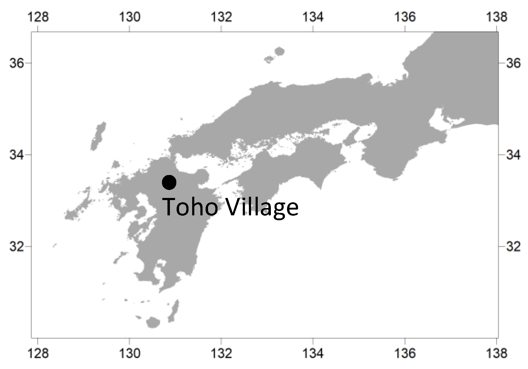
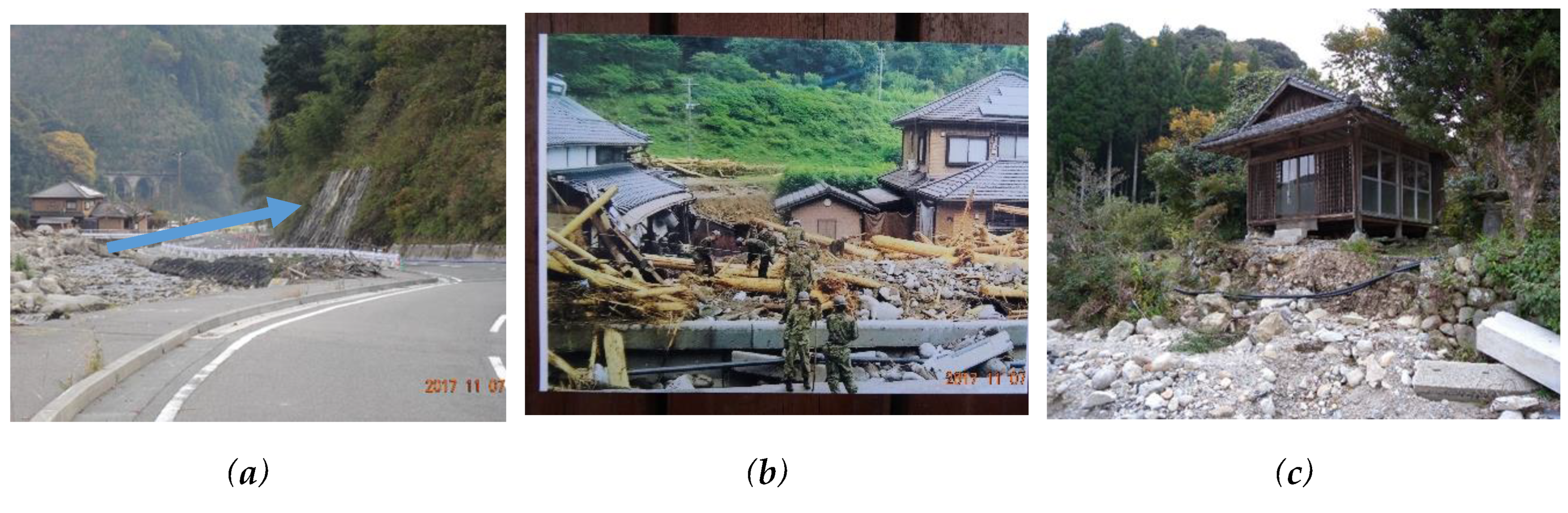
4. Study Area
5. Methods
- Question 1. Where were you, what happened around you and what did you do during the 2017 torrential rains in northern Kyushu? What influenced your actions during the heavy rain?
- Question 2. What triggered (motivated) your actions? How did you evacuate? (This question was only for people who evacuated.)
- Question 3. Do you take any daily basis, safety precautions to protect yourself from natural disasters caused by the river or/and mountain? If people notice the signs of debris flow or/and flooding—and find differences from usual rain as early as possible— they can properly response to the hazards in advance. Therefore, we asked this question about daily basis safety precautions against mountains and rivers, which lead to appropriate response to avoid damage.
6. Results
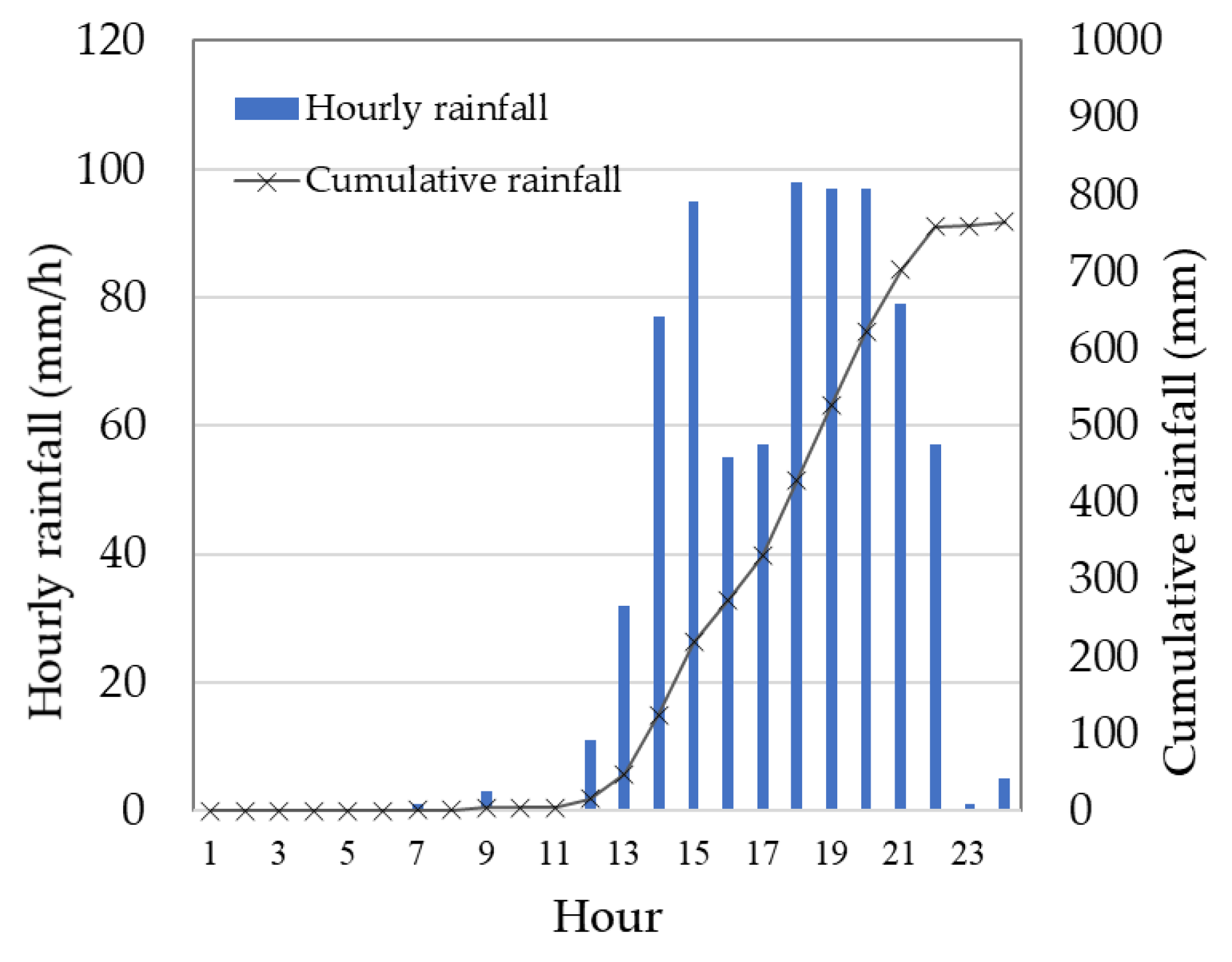
6.1. Overview of the 2017 Torrential Rains in Northern Kyushu
6.2. Activity during the Flood (Questions 1 and 2)
6.2.1. Yashii
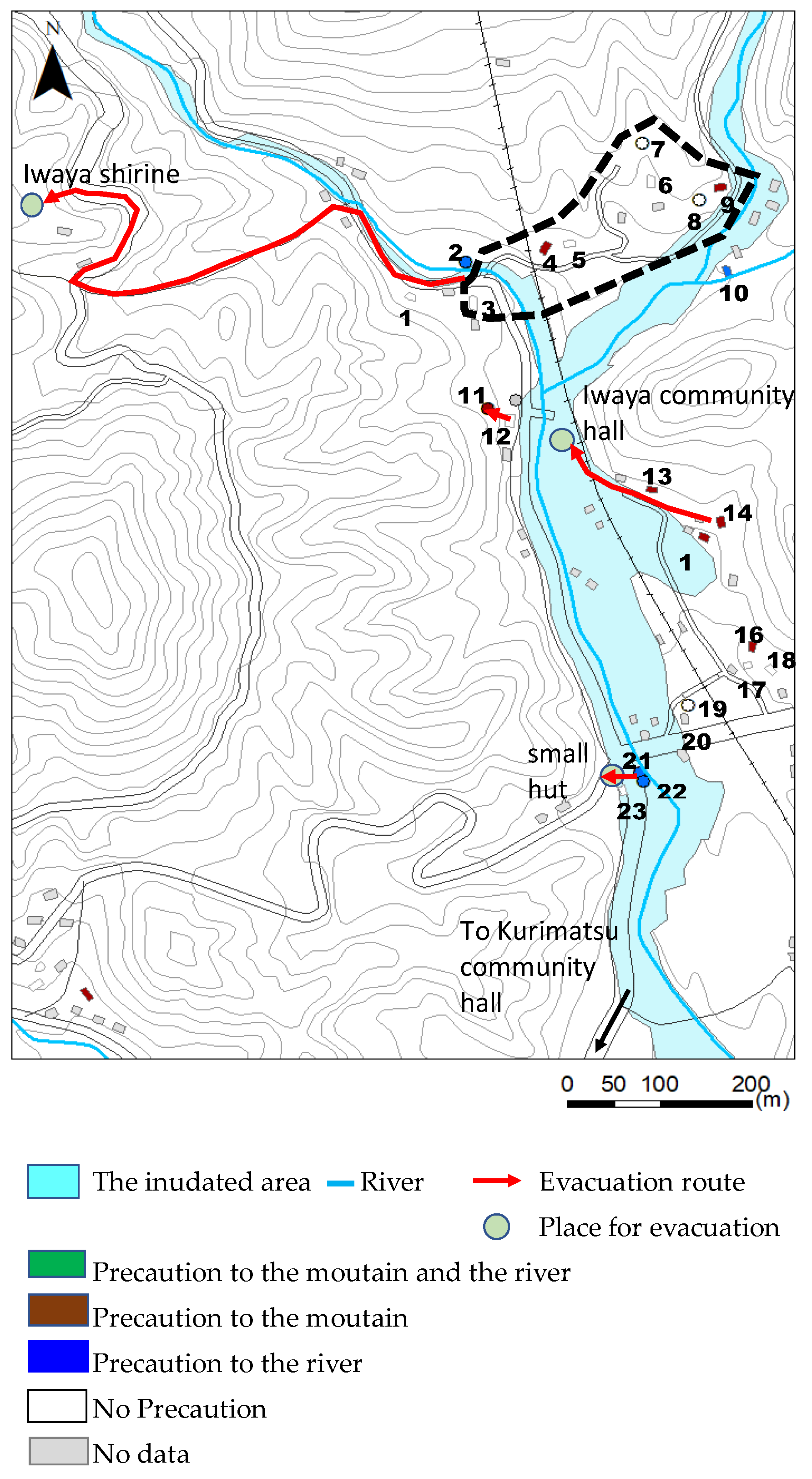
6.2.2. Iwaya
6.3. Daily Basis Safety Precautions to Protect Yourself from Natural Disasters Caused by the River or/and Mountain (Question 3)
7. Discussion
8. Conclusions
- 1)
- The people in the Yashii area made a decision to evacuate from the disaster, which may have saved their lives. Especially in the absence of immediate information (i.e., in this case, the power was out so the TV and other sources of information were unavailable), all the people were not aware that the rain was extraordinary. However, some people noticed that the rainfall was heavier than 2012 tremendous rain. It urged them to have a discussion. The discussion they had were a key factor for them to decide evacuation. In this area, there is a good neighborhood relationship in the community. The case of Yashii demonstrated that the combination of people’s precautions, awareness and the neighborhood relationship protect the community. The good neighborhood relationship is also one of the important factors for a resilient community, namely, to protect their own lives from natural disasters.
- 2)
- Because the budget and effort are limited, flood hazard maps cannot be prepared for all of the rivers. In Japan, flood hazard maps are not made for middle and small rivers. Therefore, it is difficult for people to know the flooding hazards along the middle or small rivers in Japan. On the other hand, knowledge of local landforms would be helpful for residents to reinforce their capacity to appropriately deal with infrequent disastrous rainfall. Since landform interpretation is usually difficult for ordinary local residents, it is necessary for expert to teach landforms, its formation and hazards to the local residents. The risk communication between local residents and experts must strengthen the community resilience.
Author Contributions
Funding
Acknowledgments
Conflicts of Interest
References
- Kron, W.; Eichner, J.; Kundzewiz, W. Reduction of flood risk in Europe-Reflections from a reinsurance perspective. J. Hydrol. 2019, 576, 197–209. [Google Scholar] [CrossRef]
- Trias, A.; Lassa, J.; Surjan, A. Connecting the actors, discovering the ties: Exploring disaster risk governance network in Asia and the Pacific. Int. J. Disaster Risk Reduct. 2019, 33, 217–228. [Google Scholar] [CrossRef]
- ESCAP. Disasters without Borders, Regional Resilience for Sustainable Development; Asia-Pacific Disaster Report 2015. Available online: https://www.unescap.org/sites/default/files/apdr2015-brochure.pdf (accessed on 2 April 2020).
- IPCC. Climate Change 2014; Synthetic Report. Available online: https://archive.ipcc.ch/pdf/assessment-report/ar5/syr/SYR_AR5_FINAL_full_wcover.pdf (accessed on 2 April 2020).
- Seebauer, S.; Ortner, S.; Babcicky, P.; Thaler, T. Bottom-up citizen initiatives as emergent actors in flood risk management: Mapping roles, relations and limitations. J. Flood Risk Manag. 2019, 12, e12468. [Google Scholar] [CrossRef] [PubMed] [Green Version]
- UNISDR. Sendai Framework for Disaster Risk Reduction 2015–2030. Available online: https://www.preventionweb.net/files/43291_sendaiframeworkfordrren.pdf. (accessed on 2 April 2020).
- Zia, A.; Wagner, C. Mainstreaming early warning systems in development and planning processes: Multilevel implementation of Sendai Framework in Indus and Sahel. Int. J. Risk Sci. 2015, 6, 189–199. [Google Scholar] [CrossRef] [Green Version]
- Chan, E. Building Bottom-up Health and Disaster Risk Reduction; Oxford University Press: Oxford, UK, 2017. [Google Scholar]
- Koliou, M.; Lindt, J.; McAllister, P.; Ellingwood, B.; Dillard, M.; Cutler, H. State of the research in community resilience: Progress and challenges. Sustain. Resil. Infrastruct. 2018, 2–19. [Google Scholar] [CrossRef] [PubMed]
- Tiernan, A.; Drennan, L.; Nalau, J.; Onyango, E.; Morrissey, L.; Mackey, B. A review of themes in disaster resilience literature and international practice since 2012. Policy Des. Pract. 2019, 2, 53–74. [Google Scholar] [CrossRef] [Green Version]
- Parker, D.; Priest, S.; Tapsell, S. Understanding and enhancing the public’s behavioural response to flood warning information. Meteorol. Appl. 2019, 16, 103–114. [Google Scholar] [CrossRef]
- Cai, H.; Lam, N.; Zou, L.; Qiang, Y.; Li, K. Assessing community resilience to coastal hazards in the lower Mississippi river basin. Water 2016, 8, 46. [Google Scholar] [CrossRef] [Green Version]
- Inan, D.; Beydoun, G.; Pradhan, B. Developing a decision support system for Disaster management: Case study of an Indonesia volcano eruption. Int. J. Disaster Risk Reduct. 2018, 31, 711–721. [Google Scholar] [CrossRef]
- Suzuki, T.; Watanabe, T.; Okuyama, S. Facilitating community risk communication for wide-area evacuation during large-scale floods. Int. J. Environ. Res. Public Health 2019, 16, 2466. [Google Scholar] [CrossRef] [Green Version]
- Lassa, J.; Surjan, A.; Caballero-Anthony, M.; Fisher, R. Measuring political will: An index of commitment to disaster risk reduction. Int. J. Disaster Risk Reduct. 2019, 34, 64–74. [Google Scholar] [CrossRef]
- Cutter, S.L.; Barnes, L.; Berry, M.; Burton, C.; Evans, E.; Tate, E.; Webb, J. A place-based model for understanding community resilience to natural disasters. Glob. Environ. Chang. 2008, 18, 598–606. [Google Scholar] [CrossRef]
- Norris, F.H.; Stevens, S.P.; Pfefferbaum, B.; Wyche, K.F.; Pfefferbaum, R.L. Community Resilience as a metaphor, theory, set of capacity, and strategy for disaster readiness. Am. J. Community Psychol. 2008, 41, 127–150. [Google Scholar] [CrossRef] [PubMed]
- Bruneau, M.; Chang, S.E.; Eguchi, R.T.; Lee, G.C.; O’Rourke, T.D.; Reinhorn, A.M.; Shinozuka, M.; Tierney, K.; Wallace, W.A.; von Winterffeldti, D. A framework to quantitatively access and enhance the seismic resilience of communities. Earthq. Spectra 2003, 19, 733–752. [Google Scholar] [CrossRef] [Green Version]
- Paton, D.; Millar, M.; Johnston, D. Community resilience to volcanic hazard consequences. Nat. Hazards 2001, 24, 157–169. [Google Scholar] [CrossRef]
- Paton, D.; Johnston, D. Disasters and communities: Vulnerability, resilience and preparedness. Disaster Prev. Manag. 2001, 10, 270–277. [Google Scholar] [CrossRef]
- Wang, F.; Wu, Y.; Yang, H.; Tanida, Y.; Kamei, A. Preliminary investigation of the 20 August 2014 debris flows triggered by a severe rainstorm in Hiroshima City, Japan. Geoenviron. Disasters 2015, 2, 17. [Google Scholar] [CrossRef] [Green Version]
- Liu, W.; Yamazaki, F. Review article: Detection of inundation areas due to the 2015 Kanto and Tohoku torrential rain in Japan based on multi-temporal ALOS-2 imagery. Nat. Hazards Earth Syst. Sci. 2018, 18, 1905–1918. [Google Scholar] [CrossRef] [Green Version]
- Hazarika, H.; Yamamoto, S.; Ishizawa, T.; Danjyo, T.; Kochi, Y.; Fujishiro, T.; Okamoto, D.; Matsumoto, D.; Ishibashi, S. The 2017 July northern Kyushu torrential rainfall disaster-Geotechnical and geological perspectives. In Geotechnics for Natural Disaster Mitigation and Management. Developments in Geotechnical Engineering; Krishna, A., Katsumi, T., Eds.; Springer: Singapore, 2020. [Google Scholar]
- River Council for Social Infrastructure Development, Flood Risk Management for Wide-Area and Long-Lasting Rainfall—Multi-Layered Countermeasures for Complex Disasters. 2018. Available online: http://www.mlit.go.jp/river/mizubousaivision/toushin_e/1812_flood_risk_management_e.pdf (accessed on 2 April 2020).
- Cabinet Office, Government of Japan. 2017. Available online: http://www.bousai.go.jp/fusuigai/kyusyu_hinan/pdf/dai1kai/siryo2.pdf (accessed on 17 March 2020). (In Japanese).
- The Nishinippon Shimbun CO., LTD. 2019. Available online: https://www.nishinippon.co.jp/item/n/568040/ (accessed on 17 March 2020). (In Japanese).
- Toho Village Home Page. Available online: http://vill.toho-info.com/sdata (accessed on 17 March 2020). (In Japanese).
- Cabinet Office, Government of Japan, Bousai. 2017. Available online: http://www.bousai.go.jp/kohou/kouhoubousai/h29/88/pdf/bs17autumn.pdf (accessed on 17 March 2020). (In Japanese).
- Japan Meteorological Agency. Available online: http://www.data.jma.go.jp/obd/stats/etrn/index.php (accessed on 17 March 2020). (In Japanese).
- Toho Village. 2017. Available online: http://vill.toho-info.com/ (accessed on 17 March 2020). (In Japanese).
- Katada, T.; Kanai, M. The school education to improve the disaster response capacity: A case of “Kamaishi Miracle”. J. Disaster Res. 2016, 11, 845–856. [Google Scholar] [CrossRef]
- Paul, B.K. Why relatively fewer people died? The case of Bangladesh’s Cyclone Sidr. Nat. Hazards 2009, 50, 289–304. [Google Scholar] [CrossRef]
- Parvin, G.A.; Sakamoto, M.; Shaw, R.; Nakagawa, H.; Sadik, M.S. Evacuation scenarios of cyclone Aila in Bangladesh: Investigating the factors influencing evacuation decision and destination. Prog. Disaster Sci. 2019, 2, 100032. [Google Scholar] [CrossRef]
- Manyena, S.B. The concept of resilience revisited. Disasters 2006, 30, 433–450. [Google Scholar] [CrossRef] [PubMed]
- Aldrich, D.P.; Meyer, M.A. Social capital and community resilience. Am. Behav. Sci. 2015, 59, 254–269. [Google Scholar] [CrossRef]
- Tanaka, A.; Ichikawa, J.; Miyagawa, Y.; Yoshii, H.; Jibiki, Y.; Udagawa, S.; Sekiya, N.; Nakamura, I.; Matsuo, I. A survey for residents’ behavior affected by a torrential rain: A case study from the town of Sayo in Hyogo prefecture in 2009. Available online: http://www.iii.u-tokyo.ac.jp/manage/wp-content/uploads/2016/03/20110427-rsrNo27_2.pdf (accessed on 17 March 2020). (In Japanese).
- Toho Village Debris-Related Hazard Map. Available online: http://www1.vill.toho.fukuoka.jp/file/temp/679895.pdf (accessed on 17 March 2020). (In Japanese).


| Time | Action |
|---|---|
| 13:14 | ▪ Heavy rain flood warning was issued by Fukuoka Regional Headquarters, Japan Meteorological Agency (JMA) ▪ Disaster alert headquarter was established at Toho Village |
| 13:30 | ▪ An alert was broadcasted through emergency broadcast system by the disaster alert headquarter of Toho Village |
| 14:10 | ▪ Real time landslide risk warning was issued by Fukuoka Regional Headquarters, JMA ▪ Disaster alert headquarter was established in Fukuoka prefecture |
| 14:17 | ▪ Evacuation preparation information was issued over all the Toho village by Disaster alert headquarter of Toho village |
| 15:15 | ▪ Evacuation advisory was issued over all the Toho village by Disaster alert headquarters of Toho village |
| 15:30 | ▪ Disaster Management Headquarters of Toho village was established ▪ Disaster Management Headquarters of Fukuoka prefecture was established |
| 17:51 | ▪ Emergency warning for heavy rainfall was issued by Fukuoka Regional Headquarters |
| ID | Neighbor Relationship | Location | Conditions | Actions | Motivation |
|---|---|---|---|---|---|
| 1 | Good | Not home | |||
| 2 | - | Not home | |||
| 3 | - | Home | She decided to evacuate after getting information about occurrence of landsides from a neighbor. She evacuated to a higher place across the river with a nephew living nearby by his car. | Getting information about occurrence of landsides from a neighbor. | |
| 4 | Good | Home | She heard the roar of the river in the afternoon. 15:30: Power outage | She evacuated to a higher place across the river with neighbors by car. | Talking with neighbors |
| 5 | Good | Home office | Sudden strong rain occurred in the afternoon 15:15: Saw a house washed away | He decided to evacuate after talking with neighbors. He evacuated to a higher place across the river with neighbors by car. | Witnessing a house be washed away |
| 6 | Good | Home | 15:00–15:30: Heard the roar of the river and witnessed splashes 15:30: Telephone not working | She decided to evacuate after talking with neighbors. She evacuated to a higher place across the river with neighbors by car. | Talking with neighbors |
| 7 | Good | Home | 15:00: Heard the roar of the river and witnessed splashes | He decided to evacuate after talking with neighbors. He evacuated to a higher place across the river with neighbors by car. | Talking with neighbors |
| 8 | Good | Home | Too afraid to look outside | She decided to evacuate after talking with neighbors. She evacuated to a higher place across the river with neighbors by car. | Talking with neighbors |
| 9 | - | Home | Various things were flowing around her home. | She evacuated to a higher place across the river with neighbors by car. | Phone call from her son to evacuate |
| 10 | - | Not home | |||
| 11 | Good | Home | 14:30: The road was submerged, and the car was almost soaked. The rain was so heavy. 15:00: Power outage | She stayed at home on 5 July with her husband and neighbors who had evacuated their home. On 6 July, they evacuated to a higher place across the river where other people were. | Police patrol |
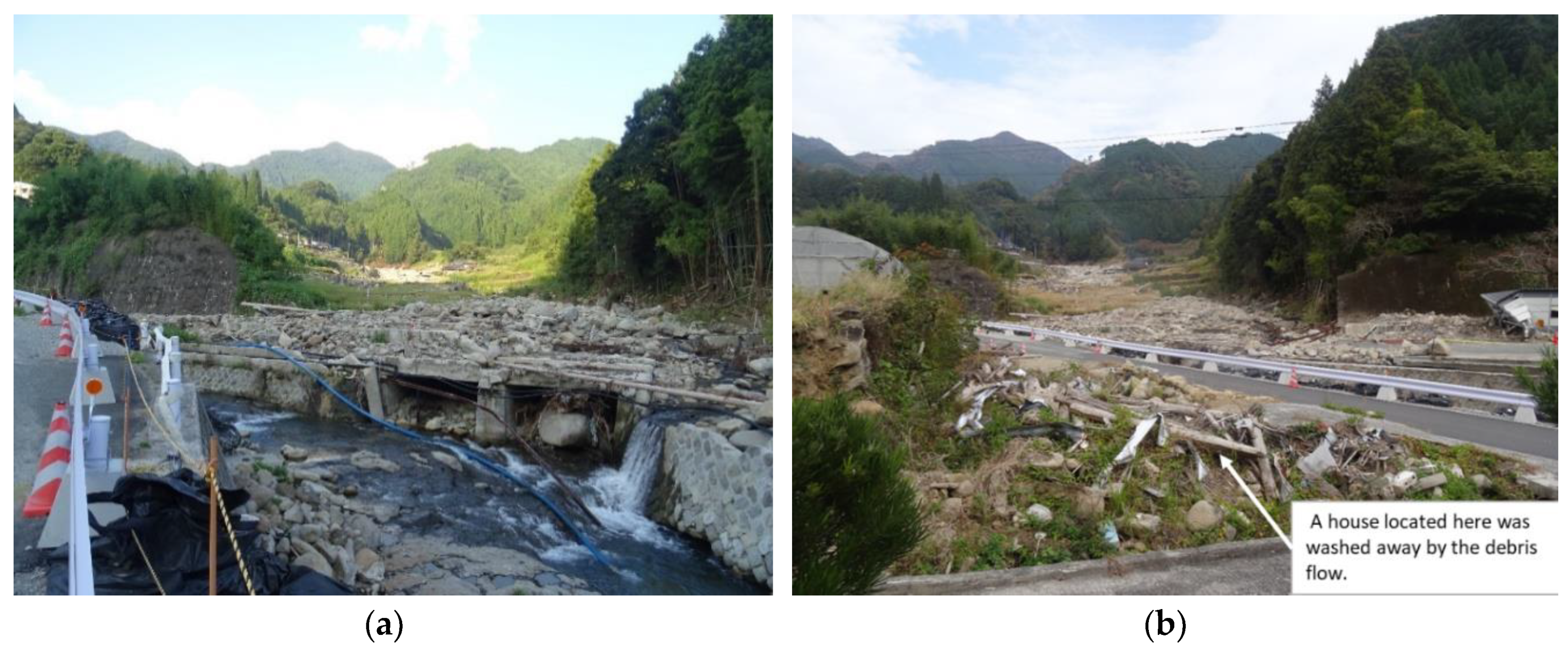
| 12 | - | Home | 15:00: Power outage 15:30: Flooding river 16:30: Debris flow occurred. Some buildings and a bridge were washed away | She evacuated to a neighbor’s house with her children on 5 July and to higher ground on 6 July. | Witnessing the debris flow |
| 13 | Good | Not home | He could not go home because of inundation. | ||
| 14 | Good | Home | She saw the river had overflowed and saw wooden flotsam in the floodwater | She and her husband evacuated to the Iwaya Community Hall, which was designated as an “evacuation place”. | Looking at the river and mountain conditions |
| 15 | Good | Not home | |||
| 16 | Good | Home | She saw a bridge had been damaged and buildings along the river were damaged. | He evacuated to Kurimatsu Community Hall with his wife. | Evacuation preparation information issued by the local government |
| 17 | Good | Home | Roads were inundated around the house. | He stayed home. | Thinking that his home was safer than the community hall |
| 18 | Good | Home | Roads were inundated around her house and her house was isolated. | She stayed home because roads were inundated around her house and her house was isolated. | |
| 19 | Good | Home | The road flooded and a huge rock, wood and a broken steel frame were moving with the floodwater. | She stayed at home on 5 July because she thought that staying home is safer than evacuation | |
| 20 | - | Not home | |||
| 21 | Good | Not home | All family members were not home. They learned of the conditions through neighbors who sent photos. | ||
| 22 | - | Home | 15:00: Road flooded | She evacuated to a nearby hut located on higher ground. | The road in front of their house flooded. |
| 23 | Not so good | Home | Because of wooden flotsam, the house was damaged. | He evacuated to a nearby hut located on higher ground. | Because of driftwood, the house was damaged. |
© 2020 by the authors. Licensee MDPI, Basel, Switzerland. This article is an open access article distributed under the terms and conditions of the Creative Commons Attribution (CC BY) license (http://creativecommons.org/licenses/by/4.0/).
Share and Cite
Nonomura, A.; Fujisawa, K.; Takahashi, M.; Matsumoto, H.; Hasegawa, S. Analysis of the Actions and Motivations of a Community during the 2017 Torrential Rains in Northern Kyushu, Japan. Int. J. Environ. Res. Public Health 2020, 17, 2424. https://doi.org/10.3390/ijerph17072424
Nonomura A, Fujisawa K, Takahashi M, Matsumoto H, Hasegawa S. Analysis of the Actions and Motivations of a Community during the 2017 Torrential Rains in Northern Kyushu, Japan. International Journal of Environmental Research and Public Health. 2020; 17(7):2424. https://doi.org/10.3390/ijerph17072424
Chicago/Turabian StyleNonomura, Atsuko, Kazuhito Fujisawa, Mari Takahashi, Hideo Matsumoto, and Shuichi Hasegawa. 2020. "Analysis of the Actions and Motivations of a Community during the 2017 Torrential Rains in Northern Kyushu, Japan" International Journal of Environmental Research and Public Health 17, no. 7: 2424. https://doi.org/10.3390/ijerph17072424