Article

Development of Offshore Wind Power: Contrasting Optimal Wind Sites with Legal Restrictions in Galicia, Spain

1
Environmental Physics Laboratory, Universidade de Vigo, Campus As Lagoas s/n, 32004 Ourense, Spain
2
CESAM, Physics Department, Universidade de Aveiro, Aveiro 3810-193, Portugal
3
Observatorio del Litoral de la Universidad de A Coruña, 15071 A Coruña, Spain
*
Author to whom correspondence should be addressed.
Energies 2018, 11(4), 731; https://doi.org/10.3390/en11040731
Submission received: 29 January 2018 / Revised: 14 March 2018 / Accepted: 20 March 2018 / Published: 23 March 2018
(This article belongs to the Section A: Sustainable Energy)

Abstract

:
The region of Galicia, in the northwest of the Iberian Peninsula, has a high wind potential for the installation of offshore wind farms (OWFs) in many areas of its surrounding marine waters. However, legal restrictions derived from the protection of other interests that converge in the marine environment (such as fishing, navigation, and biodiversity conservation) must be considered, along with technical limitations resulting from water depth. This study is aimed at analysing legal restrictions on the installation of OWFs in Galician waters and at identifying those zones of less conflict where the wind power density (WPD) is greater and the depths and distances from the coast are technically feasible given the current status of technology in Europe. To do this, a legal study was performed of both the strategic environmental assessment of the Spanish coast and the regulations of the different marine sectors at European, international, national, and regional levels. In addition, the WPD along the north-western area of the Iberian Peninsula and Europe was calculated, and an analysis of maximum and average depths and distances from the coast of planned and installed OWFs in Europe was made. Two main zones without legal and technical restrictions were identified in the north-eastern corner of Galicia and in the south of the Vigo estuary. The greatest WPD was identified in the north-western zone, from Cape Finisterre to Cape Ortegal, where there are small sites without legal or technical restrictions that are near several protected zones (such as a marine reserve, a special protected area, and a wetland and its buffer zone), making necessary a deeper analysis of the specific impacts of each OWF project in the Environmental Impact Assessment.

1. Introduction

The production of electricity from offshore wind farms (OWFs) is an important source of renewable energy in many European countries, such as the UK (with an installed capacity of 5156 MW), Germany (4108 MW), Denmark (1271 MW), the Netherlands (1118 MW), Belgium (712 MW), and Sweden (202 MW) [1].
Spain—especially the region of Galicia, located in the northwest of the Iberian Peninsula—has a high offshore wind resource, the exploitation of which could help achieve the national goal established by the Spanish National Renewable Energy Action Plan (NREAP) 2011–2020 of installing 750 MW of offshore wind power in Spanish maritime waters by 2020 [2,3,4,5]. This could also help meet the European goal of ensuring that at least 20% of final consumption comes from renewable energy sources by 2020—as required by Directive 2009/28/CE [6]. However, the Spanish coast does not yet have any wind farm installed for commercial purposes [4]. This is due in part to its narrow continental shelf and the difficulty of installing OWFs in shallower waters near the coast because of increased conflict with other interests legally protected by international, European Union (EU) and domestic law that converge in the marine environment, such as those related to the protection of the marine landscape, the recovery of fish stocks, the safety of navigation, the conservation of the marine environment and biodiversity (e.g., protected areas or species) and the development of other permitted activities at sea (e.g., shellfish gathering, fishing, tourism…) [2,4,7,8]. The scientific literature and legal doctrine have identified numerous sectors that may be affected by the installation of OWFs:
(1)
Tourism and recreational activities, especially due to the visual impact of wind turbines [9,10,11].
(2)
Marine ecosystems, especially marine protected areas and species, which may suffer negative impacts from OWFs [4,9,10]. In this regard, the risk of collisions of birds and bats against the rotor blades have been reported [12]. In addition, marine mammals can be affected by noise, vibrations, and electromagnetic fields generated during the construction and maintenance phases of marine wind farms [12,13].
(3)
Traditional local fishing and shellfish gathering, due both to the technical impossibility of the boats fishing in the area and the changes caused in the migratory routes of the fish [8,10]. However, positive effects have also been observed on marine species, due both to the impossibility of carrying out trawler fishing within the area where OWFs are located, and the fact that these facilities can act as artificial reefs around which a new marine habitat can be created [4,14]. Some promoters of OWFs have proposed the joint installation of OWFs and offshore aquaculture in the same area as an innovative way to maximize profits [4].
(4)
Maritime navigation. In this regard, the location of OWFs could force fishing, recreational, and commercial vessels to change routes, with consequent extra costs [10,12].
(5)
Other activities, such as submerged underwater heritage—especially wrecks—still unexplored [10], aerospace navigation, military defence, oil and gas facilities, and dredging areas [12].
All these interests that converge in the marine environment are protected by different legal norms—scattered throughout the Spanish legal system—which can establish limits to the installation of marine wind farms.
Although the Spanish central state has exclusive competence to regulate many of these matters and the Constitutional Court has pointed out that the territorial sea is not part of the territory of the Spanish coastal regions, these have competences—assigned by their respective autonomy statutes and the Spanish Constitution—in other areas that may also be affected by the installation of OWFs [7]. Thus, as a general rule, the Spanish central state has the power to regulate marine renewable energy, national navigation, fishing beyond internal waters, ports of general interest, and the core standards of protection of the marine environment; while coastal regions have regulatory powers regarding coastal management, shellfish gathering, fishing in internal waters (which are those located on the landward side of the baseline of the territorial sea), regional navigation, culture, heritage, and additional protection of the environment.
As a result, there may be locations where wind conditions are optimal for the installation of OWFs but which are nevertheless subject to legal restrictions derived from state and/or regional legislation protecting other interests that may conflict with the implementation of these facilities [15].
In 2009, the Ministry of the Environment and the Ministry of Energy and Industry prepared the Strategic Environmental Assessment of the Spanish Coast for the Installation of OWFs (SEA) in order to assess the effects of OWFs on the marine environment within the first 24 nautical miles off the coast —considering that this marine area were sufficiently broad since it was not expected that development of OWFs farms in the Exclusive Economic Zone in the short or medium term would occur due to the depth of Spanish waters and the state of the technology on the date of its adoption (2009). The SEA establishes three types of zones within this 24-nautical-mile area [16]:
-
‘exclusion zones’, where the installation of OWFs is directly excluded because significant environmental effects have been identified.
-
‘suitable zones with environmental constraints’, where several environmental effects and conflicts have been identified and further analysis in the Environmental Impact Assessment (EIA) of OWF projects will be necessary.
-
‘suitable zones’, where the environmental effects are few in comparison with the advantages of OWF implementation. Although these are the most suitable locations, OWF projects that are to be located there will also be subject to EIA.
It is important to make clear that the purpose of a strategic environmental assessment is to assess the effects of plans and programmes on the environment—as it is defined by the Spanish Environmental Assessment Act 21/2013 and the Directive on Strategic Environmental Assessment 2001/42/EC—rather than directly prohibiting specific areas for development. However, the Royal Decree 1028/2007—which governs the procedure for processing applications for the authorization of electricity generation facilities in Spanish waters—establishes in its third additional provision that developers can only apply for the license to investigate the wind resource (and thus, the subsequent license to install the OWF) in those areas not considered as ‘exclusion zones’ by the Strategic Environmental Assessment of the Spanish Coast for the installation of OWFs (SEA)[17]. Thus, at the practical level, it is not allowed to install OWFs in those locations considered as ‘exclusion zones’ by the SEA on the basis of the third additional provision of Royal Decree 1028/2007.
The SEA provides key information about those locations where potential conflicts of OWFs with other users are fewer. However, it does not offer a detailed and complete analysis of the main international, EU, national and regional legislation that justifies the existence of non-suitable areas for the installation of OWFs nor consider other variables which have direct influence on the development of offshore wind farms—such as the wind potential or the depths at which is currently technically feasible to install these devices. This paper provides a multidisciplinary approach which seeks to expand and deepen knowledge on the main legal restrictions that must be considered before planning and developing an offshore wind project in the region of study and to jointly identify those areas where the wind potential is greater, it is technically feasible to install these devices and there are no conflicts with other legally protected interests that converge in the marine environment. This approach can assist politicians and planners in the integration of OWFs in the decision making and planning processes.
Currently, under Directive 2014/89/EU on maritime spatial planning—transposed into Spanish domestic law by Royal Decree 363/2017—the Spanish state must prepare marine spatial plans (MSPs) in its different marine demarcations before 31 March 2021 [18]. These MSPs must establish a space-time distribution of the main present and future activities that converge on the marine environment, such as the exploitation of marine renewable energies.
Maritime spatial planning is an opportunity for the development of OWFs in Spain. However, when selecting the best locations to install these facilities, not only the best available wind resources must be considered but also the legal restrictions established by the different state and regional regulations of the different marine sectors.
Both the increased pressures on the marine environment and the growing demand for marine space, which have motivated the adoption of the Directive on maritime spatial planning, justify a holistic management of the multiplicity of marine uses—including the exploitation of marine renewable energies [7,19]. In this sense, knowing the legislation governing each use and the protection of the marine environment can help planners and regulators enhance an integrated management of all those interests that converge in the marine environment in order to achieve a balance between economic, social and environmental dimensions of sustainable development, which are the main target of the integrated EU marine policy [18]. For all these reasons, this study is aimed at increasing knowledge about the legal aspects related to the installation of marine renewable energies and the management of the marine space and resources through the analysis of the main legislation that governs the different uses and interests with which OWFs can enter into conflict, taking the region of Galicia as a case study, due both to its high wind potential and the variety of interests that may conflict with OWFs.
On the other hand, the importance of adopting decisions more based on scientific knowledge by politicians and regulators, as established by Wright [20] and Simas et al. [21], justifies the need to develop multidisciplinary studies in which a joint analysis of scientific and legal aspects is conducted. In this sense, the second objective of this research is the identification in the study region of those areas where the wind potential is high, the installation of OWFs is technically feasible and there are not legal restrictions.
Thus, the objective of this research work is twofold, by one hand, to conduct a detailed analysis of the main legal restrictions on offshore wind implementation in Spain resulting from the protection of other interests that converge in the sea—taking the region of Galicia as a case study—and by other hand, to perform a joint analysis of the most appropriate locations to install offshore wind farms in Galician waters from both a legal and meteorological perspective. In this way, the wind energy resource will be evaluated by means of high spatial resolution wind data provided by the Galician Meteorology Agency (MeteoGalicia) with the aim of obtaining a detailed map of wind power density (WPD). Therefore, the wind energy resource will be analyzed in conjunction with legal restrictions to provide a detailed map with the most suitable locations for the installation of wind offshore farms. The situation in the region of Galicia will be contextualized by analyzing the distances from the coast, depths and also WPD values of almost 400 installed and planned offshore wind farms in Europe, which will allow to provide a more realistic view of the potential for the installation of OWFs in the area under scope.
The scientific innovativeness of this research work lies in: (i) its multidisciplinary approach, by jointly analyzing legal, meteorological and technical variables related to the development of OWFs. (ii) its contribution to increase knowledgeable about the importance of legislation in the development of OWFs. (iii) the specific legal study and the level of detail of the identification and mapping of each of the legally protected areas (in which OWFs are excluded) along with the analysis of the offshore wind energy resource (by means of WPD calculation) in the region of study.
A non-systematic overview of several key research works is conducted in Section 2. The methodological aspects of this research work are detailed in Section 3. An overview of the current status of OWFs in European context is conducted in Section 4. Legal restrictions on the development of OWFs—due to the protection of other uses and interests that converge in the marine environment—are analyzed in Section 5. Results are shown in Section 6 by identifying and mapping the best locations to install OWFs under a legal, physical and technical point of view. Finally, both the discussion and concussions are provided in Section 7.

2. Overview of the Previous Relevant Work

Previous studies have analyzed wind pattern and offshore wind energy resource in the area under scope. Thus, studies that analyzed offshore wind energy resource along the Atlantic coast of the Iberian Peninsula through numerical weather prediction model [22,23] found that the highest values along this area are reached in the northwestern area of the Iberian Peninsula with annual values around 500 W m−2 for a height of 120 m above sea surface level. More recently, Salvação and Soares (2018) [24] for the same region found that the Galician coast is the area with the highest annual energy density with values up to 971 W m−2 at 80 m above sea surface level north of Cape Finisterre. In a European context, Kalogeri et al. (2017) [25] analyzed the offshore wind power potential through high resolution numerical modeling systems in Europe. These authors catalogued the northwestern tip of the Iberian Peninsula, together with the northern area of the North Sea and the northwestern offshore areas northern than 45° N, as one of the locations with the highest offshore wind energy potential.
In order to analyze the future viability of offshore wind farms it is also recommendable to take into account the future projections for wind, especially, in a context of climate change. These types of analysis are carried out by using climate models, which in turn uses wind data from different greenhouse emission scenarios [26]. Overall, different analysis [27,28,29] agree that in the mid-future and also in the end of the 21st century a decreasing of mean wind speed is expected in most areas of Europe, with some exceptions such as northern seas or Baltic sea. However, Soares et al. [30] analyzed the future offshore wind resource along the western area of the Iberian Peninsula by the means of future projections in the framework of the CORDEX project, which has a better spatial resolution than the previous mentioned studies. These authors estimated an overall decrease around 5% in offshore wind power along the western Iberia Peninsula for the 21st century, with the exception of the Galician coast, where they noticed no changes or even a slight increase in annual means according to some models. This null trend is mainly motivated by an increase of wind power during summer (up to 20%), which compensate the decreasing observed in the remaining seasons.
Therefore, previous studies analyzing the present situation and also the future offshore wind energy potential in the northwestern area of the Iberian Peninsula suggest that Galicia is a region with optimal characteristics in terms of wind speed for the development of this renewable energy when compared with the rest of Europe.
However, the implementation of marine renewables in this Spanish Coastal Region is not exempt from limitations. In this regard, Regueiro-Ferreira and Villasante [9] pointed out the need to consider the narrowness of the Galician continental shelf and OWF impacts on beaches, tourism, landscapes, and the marine environment. Castro-Santos and Diaz-Casas [15] calculated the restrictions on the installation of floating OWFs in the region of Galicia in light of two types of limitations: general location restrictions—navigation, fisheries, marine protected areas, seismic fault lines, rock geotechnical areas, and unsuitable areas defined by the Spanish government—and limitations caused by the depth of the Galician waters. Castro-Santos et al. [31] identified the area between the Pontevedra estuary and the Ribadeo estuary as the most economical area to install floating wind farms, pointing out that semi-submersible platforms and spar platforms are the most highly recommended floating platforms in economic terms. Rodríguez-Rodríguez et al. [4] highlighted the difficulty of conducting several of the offshore wind projects requested in Spain to date given the new marine protected areas designated since 2009, which have increased the area of the exclusion zones in the SEA. However, they considered it feasible to reach the NREAP’s goal of achieving 750 MW of installed capacity by 2020 through the location of OWFs both at those sites defined as suitable zones by the SEA and at sites at greater distances from the coastline through the implementation of floating turbines. Colmenar-Santos et al. [2] studied the current status of OWF development in Europe and in Spain and analyzed the newly available technologies and the licensing process for the installation of OWFs. They also made a general comparison between the map of marine wind resources in Spain published by the IDAE and the map of 72 Offshore Wind areas considered in the SEA. They identified the depth of Spanish coasts, environmental restrictions, and social barriers as the main obstacles to achieving the NREAP 2011–2020 goal of 750 MW of offshore wind installed capacity. Many of these environmental and social interests are legally protected, being necessary an analysis of the main legislation in order to better understand the legal grounds of these restrictions. Thus, this research aims to increase knowledge of the main international, UE, national and regional legal rules which have to be considered by politicians, planners, and developers before adopting their respective decisions.
The aforementioned research works provide key information about environmental [4], meteorological (e.g., [23]), and technical variables (e.g., [31]), which direct influence in the development of OWFs in Spain (and specially, in Galician coast). However, there is no scientific paper that conducts a legal analysis of the main international, EU, national and regional legislation which have to be considered by planners and developers before planning and installing OWFs in the region of study.
Marine governance frameworks play a key role in the development of marine renewable energies [32,33]. In this sense, legal, policy and regulatory aspects, such as the duration and complexity of the licensing processes [5,21,34,35,36,37,38,39,40], the different supporting schemes [5,32,36,37,38,39,41], and the management of the marine space and resources [7,8,13,32], have been identified and studied by legal and scientific literature as variables with a direct influence on the development of marine renewable energies. However, despite the importance of legal aspects, there are few scientific articles that address these issues, and further research into these legal aspects is needed [33].
Regarding the management of the marine space and resources, Long [32] studied, among other legal factors, the influence of Maritime Spatial Planning Directive in the development of offshore wind farms concluding that that there is a need of achieving better coordination between member States in the planning processes. In this sense, Soria-Rodríguez [13] studied the efficacy of the European Regional Seas Conventions in facilitating better coordination between states of the same coastal region and increasing the marine environmental protection against the negative effects associated by marine renewable energies. Sanz [8] highlighted the great controversy that OWF projects have generated in Spain among concerned coastal local communities and strategic marine sectors—such as fishermen and shellfish gatherers—underlining the need for increased public participation, especially from those directly concerned marine sectors and administrations, such as coastal regions and local communities. In this regard, Díaz [7] highlighted the need to enhance the role of the Spanish coastal regions in the OWF planning and licensing process, seeing the implementation of Directive 2014/89/EU on maritime spatial planning as an opportunity to make progress in this respect.
However, there is no scientific paper which analyses in detail the international, EU, national and regional legislation that govern each legally protected interest which can be negative affected by the implementation of OWFs in the region of study. In this sense, this research seeks to increase knowledge about the main legislation which have to be considered before planning OWFs in Spain (and, specially, in Galician waters). This approach is in line with the legal research agenda for marine renewable energy elaborated by Wright et al. [33], which encourages the development of further research papers based on the management of the marine space and resources (among other regulatory aspects), especially with regard to the integration of marine renewable energies into MSP processes, the prioritization and/or co-existence of marine uses.
In addition, although several research papers have applied multi-criteria methods in order to select the best locations to install OWFs in different regions of study—as proposed by Ziemba et al. [42] on the basis of a sustainable assessment, taking into account social, economic and environmental criteria, there is no scientific paper that analyses in detail legal factors along with meteorological and technical criteria. In this sense, this research seeks to conduct an extensive analysis of the applicable legislation as well as identify and map those areas where there are no legal restrictions, and wind and depth conditions are favourable for installing OWFs in the region of study.

3. Methods

3.1. Analysis of Legal Restrictions on the Installation of OWFs in the Spanish Region of Galicia

In order to analyse and identify specific legal restrictions on the implementation of OWFs in the Galician coast:
International, European, and national legislation has been used as a direct source of information. The regional law of Galicia has been studied because, although according to the Constitutional Court the competences in territorial waters and the Exclusive Economic Zone (such as the installation of OWFs) belongs mainly to the Spanish state, coastal regions have different powers over the coast and within internal waters—which are those located within the baselines—the effects of which can be projected into the territorial sea [7]. In this regard, several activities over which the coastal regions have competence (such as fishing within internal waters, shellfish, coastal management, and additional environmental protection standards) may be affected by the installation of OWFs [7]. Likewise, the need to consider ‘the interaction between land and sea’ when elaborating MSPs—as required by the Directive 2014/89/EU on maritime spatial planning— as well as the need to consider cumulative impacts in SEA and EIA, means that the regional regulations of Galicia, which has extensive powers over the coast, have to be taken into account in the present research [7].
Management and strategic documents prepared by the different state and regional administrations (such as management schemes of different spaces) have been analyzed, especially the SEA. This is because, despite its limitations, it constitutes the most complete study on marine uses and environmental values to date in Spain [4].
International scientific literature and Spanish legal doctrine have been studied.

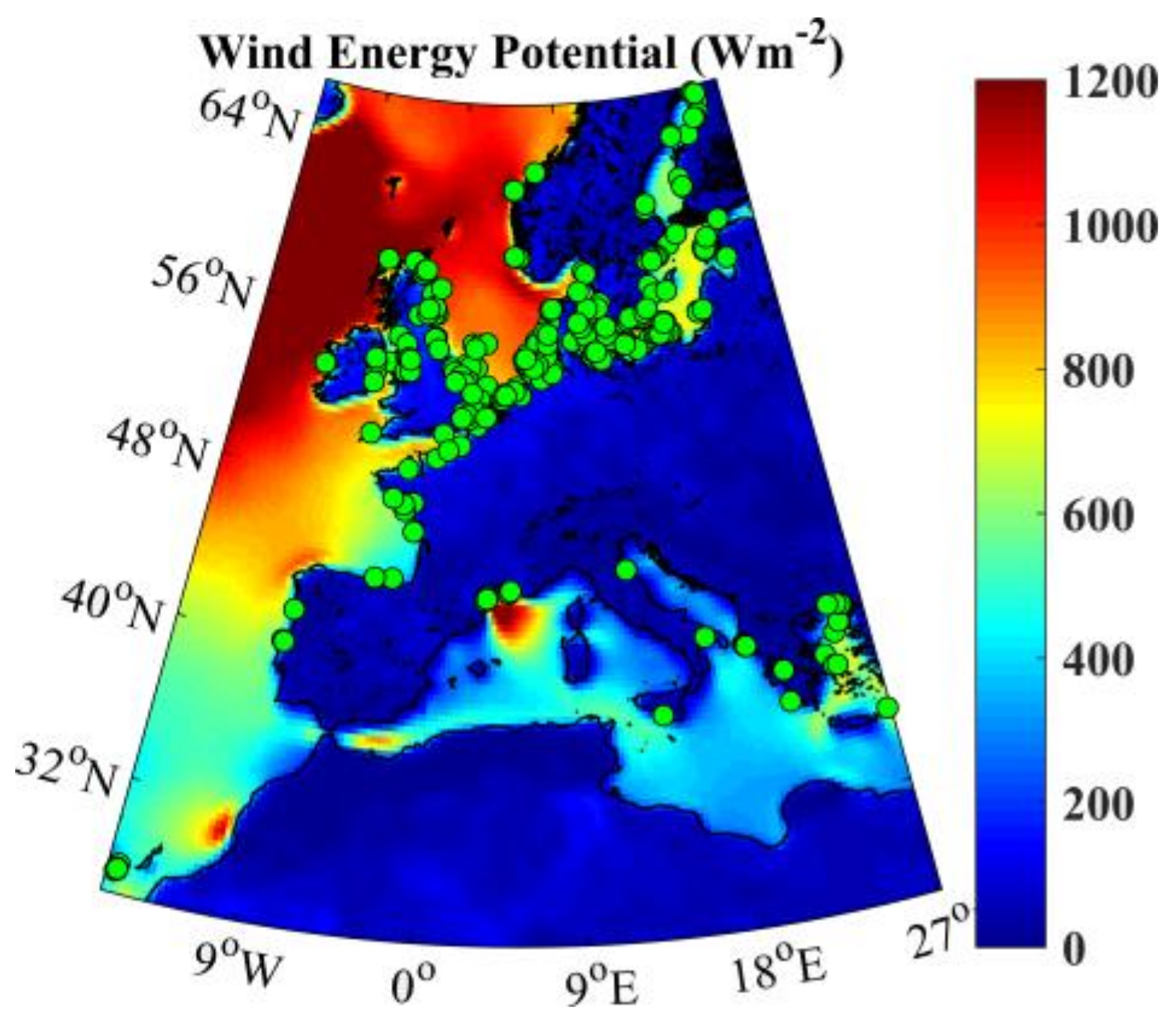
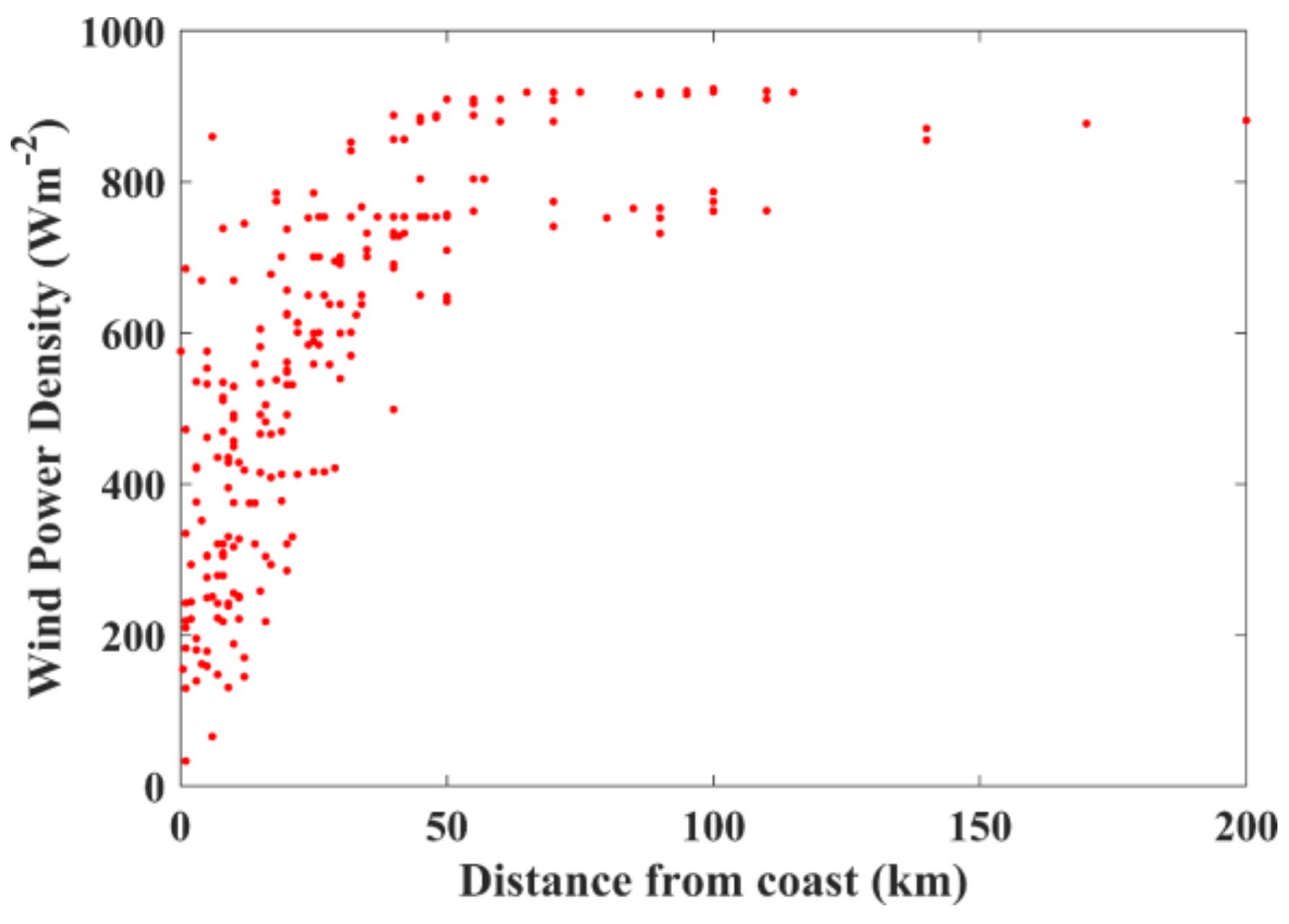
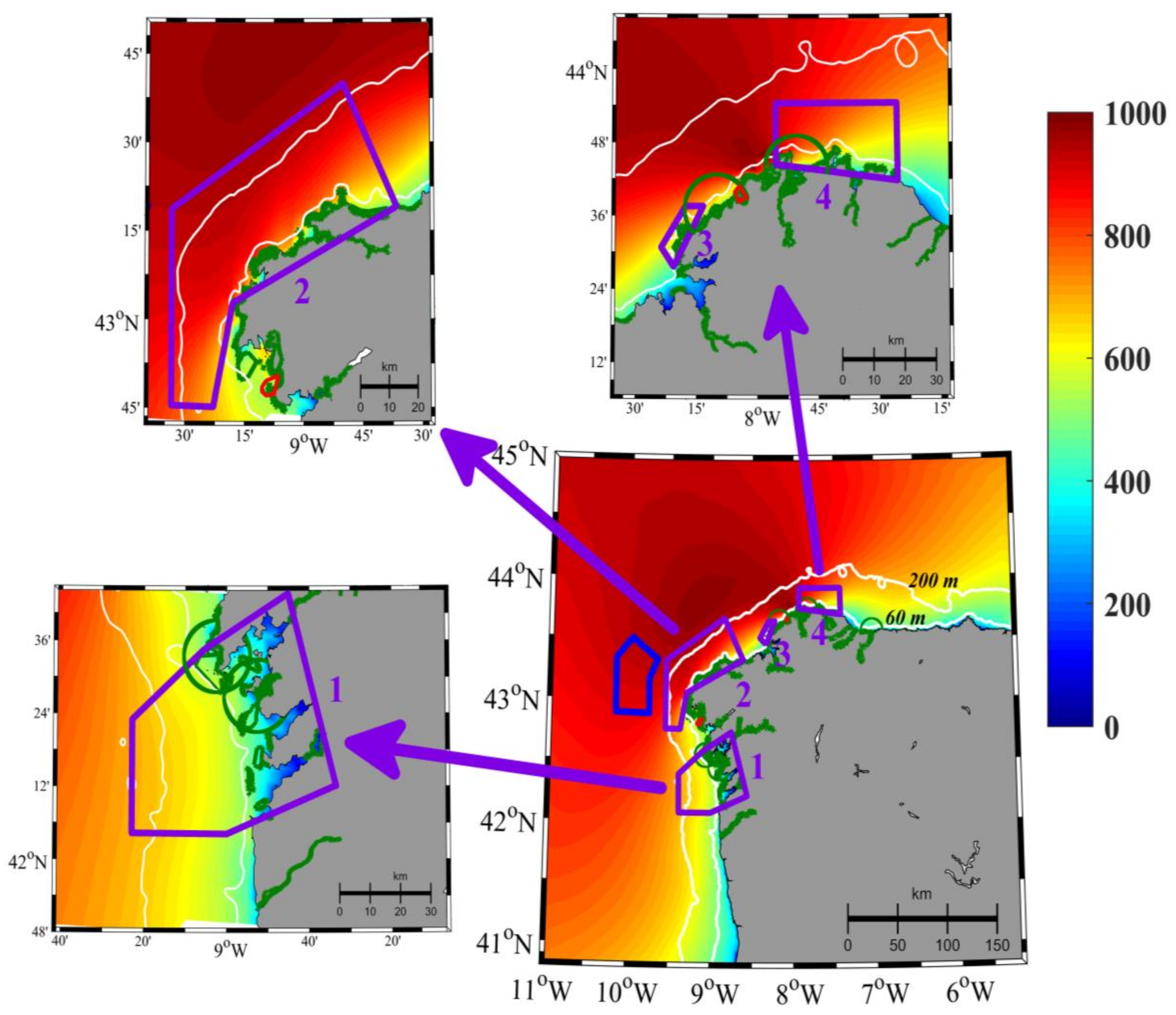
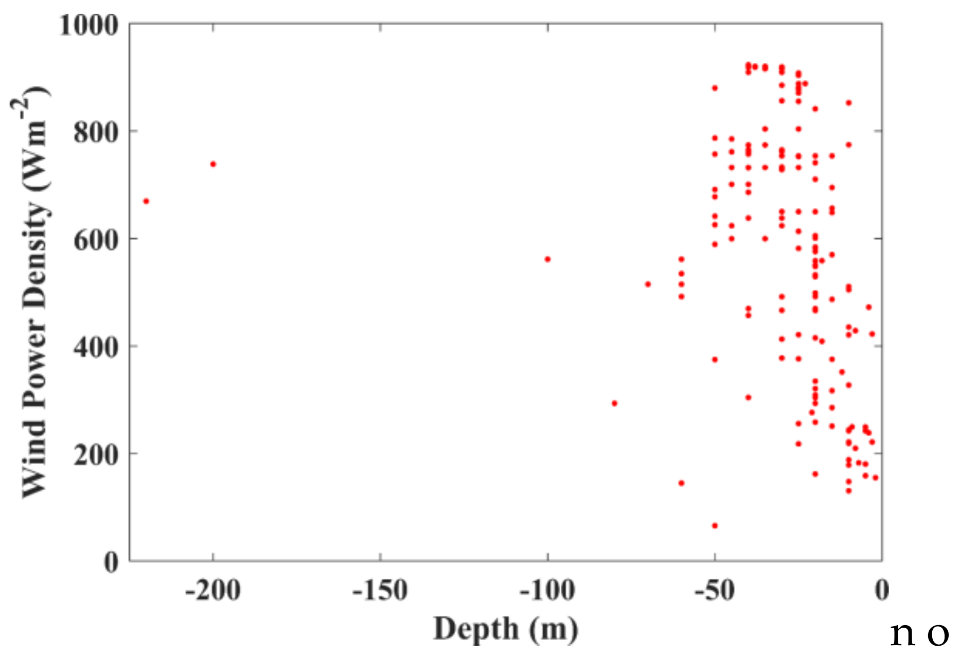
3.2. Wind Potential Calculation and Location Data

In order to characterize the wind resources along the north-western area of the Iberian Peninsula, the wind power density (WPD) was calculated. WPD (in watts per m2) indicates how much energy is available at a specific site to be converted by a wind turbine. Thus, this method is used to compare wind power potential at various locations using averaged data of wind speed [43]. It was calculated following this equation:
WPD =   1 2   ρ v 3
where ρ represents the air density, which has a value of 1.225 kg m−3 at sea level and at 15 °C, and v accounts for the wind speed (m s−1).
To calculate WPD, it is necessary to extrapolate wind speed data at 120 m, which is the typical height of offshore wind turbines (e.g., [44]). Although different methodologies can be applied to carry out this extrapolation (e.g., [45]), assuming an atmosphere with neutral stability, it is possible to carry out the extrapolation of wind data using the logarithmic wind profile expression [46].
u z = u z m × ln ( h z 0 ) / ln ( h m z 0 )
where u z m is the near surface wind speed (m s−1) at h m which is the height (m) at which near surface wind is measured (10 m in this study); uz is the mean wind speed (m s−1) at the extrapolated height (h) (120 m in this case); z0 is the local roughness length (a value of 1.52 × 10⁻⁴ m over the ocean surface is considered) [47].
The amount of energy a wind turbine can produce is proportional to the cube of the wind speed. To carry out this study, wind speed data were provided by MeteoGalicia. Daily files were retrieved from the THREDDS (Thematic Realtime Environmental Distributed Data Service) server of MeteoGalicia (http://mandeo.meteogalicia.gal/thredds/catalog.html). Specifically, wind speed data derived from the Weather Research and Forecasting (WRF) model was used. This data has a spatial resolution of four kilometres and is available from 2008 onwards for the region under study. The high spatial resolution of this dataset allows for a better representation of WPD in the north-western area of the Iberian Peninsula.
In addition, another wind data was used in order to estimate the wind energy potential in several wind parks along Europe. Thus, it is possible to provide a context in which to compare the WPD calculated in the north-western area of the Iberian Peninsula with the WPD in other European regions where many wind parks have been installed. In this way, wind data was also obtained from National Operational Model Archive and Distribution System (NOMADS) maintained at the National Climatic Data Center (NCDC) of the U.S. National Oceanic and Atmospheric Administration (NOAA) [48]. The database used was the Climate Forecast System Reanalysis (CFSR) developed by the NOAA’s National Centers for Environmental Prediction (NCEP) (http://rda.ucar.edu/pub/cfsr.html). The CFSR provides a 0.3° × 0.3° × 6 hr resolution at a global scale.
Therefore, two different datasets containing wind data were used in this study. On the one hand, we took advantage of the high resolution of the database provided by MeteoGalicia to represent the wind pattern along the Galician Coast. On the other hand, we used the CFSR dataset due to its global coverage in order to analyzed WPD in Europe.
Finally, the location of the aforementioned wind farms in Europe was obtained from the Wind Power database (https://www.thewindpower.net/). This dataset provides information about almost 400 OWFs. Of these, 93 wind farms are already operating, 280 are yet to be installed (18 are under construction, 75 have been approved, and 187 are planned), and 15 have been dismantled. To carry out this analysis, data regarding location, depth, and distance from coast were retrieved. Mean depth and mean distance from coast was calculated by averaging the data from the 388 OWFs. The location of these OWFs can be seen in Figure 1. Calculations, as well as data representation, was done by means of MATLAB software, which allows the analysis of complex wind data matrix (e.g., [49]), as well as the mapping of wind energy resource (e.g., [50]). In addition, Matlab also enables the representation of shapefiles in conjunction with the mapping of wind energy data. For this reason, it was not necessary the utilization of geographic information system (GIS) software for making this research. Shapefiles to mark the protected areas near the Galician coast were retrieved from the cartographic viewer of Xunta de Galicia (https://mapas.xunta.es/visores/conservaciondanatureza/).

4. Overview of the Current Status of OWFs in the European Context

In order to analyze the viability of future OWFs in Galicia, a comparison in terms of WPD with the situation in Europe was carried out. To this end, the features of almost 400 OWFs included in the Wind Power database were analyzed. In this study, installed wind farms and planned wind farms were considered in order to obtain a more realistic view of the future situation. Figure 1 shows the location of these wind farms, as well as the WPD estimated using the CFSR database for Europe. The North and Baltic Seas are the areas with the highest number of OWFs. It can be seen that although the Iberian Peninsula is an area with great potential for the development of this wind energy resource, the number of installed or planned OWFs is very low. The depth of each OWF and its WPD is represented in Figure 2. Most wind farms are at depths of less than 60 m. However, there are some exceptions—two wind farms were installed at depths around 200 m—which are explained by technical developments that allow the installation of wind turbines at greater depths. The mean depth for all wind farms is around 30 m. Regarding the distance from coast (Figure 3), it can be seen that the number of wind farms decreases with an increase in the distance from the coast. The longest distance was found to be 200 km, with most farms located at a distance of less than 50 km from the coast. The mean distance from the coast for all wind farms was around 32 km. In addition, to compare the offshore wind energy production in Europe with the possibilities for Galicia, it is important to know that the mean WPD of all wind farms analyzed throughout Europe is 531.09 W m−2.

5. Legal Analysis of Restrictions on the Installation of OWFs in the Spanish Region of Galicia

As mentioned previously, according to Royal Decree 1028/2007—which governs the procedure for processing applications for the authorization of electricity generation facilities in Spanish marine waters—the installation of marine wind farms is not allowed in those areas that the SEA does not consider suitable from an environmental point of view (third additional provision) [17]. Promoters who submit wind farm projects located within the zones that are not excluded by the SEA must follow the licensing procedure necessary to obtain all the necessary permits for their implementation. In this regard, the impossibility of installing OWFs can be determined at the initial stages of the licensing procedure in the event of serious risk or obstacle to navigation and maritime traffic or special environmental protection in a specific site (Article 12) [17]. Likewise, the impacts of an OWF project on navigation and marine safety will be taken into account, as well as the environmental and social impacts, among other criteria, in order to select the best bidder in a tendering process (Article 16) [17]. Subsequently, in order to install the OWF, the selected promoter has to obtain authorization, which is issued after the processing of both the EIA, in which the specific impacts of the project are evaluated, and the concession for the occupation of public domain, which requires authorization from the Ministry of Public Works if maritime safety, navigation, and human life at sea might be affected by the project [17,51].
The above shows the importance of studying in detail the legal restrictions on offshore wind farm installation derived from the protection of other interests that converge on the marine environment; these are analyzed in the following subsections. Table A1 summarizes the exclusion zones and suitable zones with environmental constraints.

5.1. Fishing, Shellfish Gathering, and Aquaculture

In Spain, the Regional Department of Fisheries and Maritime Affairs of the Regional Government of Galicia has expressed its concern about the strong negative impact that could be caused by the location of OWFs in areas close to the coast due to strong conflicts with fishing, shellfish gathering, and aquaculture [16]. These three activities are of great socio-economic importance for this coastal region, mainly due to its large fleet and the high catches from Spanish jurisdictional waters [16,52]. Therefore, it is important to take into account fishery protection areas, and the presence of fishing grounds when selecting the best location for OWFs to avoid conflicts (Article 10 of Royal Decree 363/2017 of 8 April) [53,54].
Royal Decree 1028/2007 establishes in its second additional provision the obligation to take into account the marine reserves laid down in Article 14 (ex-Article 13) of State Law 3/2001 of 26 March on sea fishing, which are areas specially dedicated for the conservation and recovery of different species and marine ecosystems [17]. At a regional level, the region of Galicia, on the basis of the exclusive powers it has in relation to fishing in internal waters, shellfish gathering, and aquaculture (Articles 149.1.19° and 148.1.11 of the 1978 Spanish Constitution and Article 27.15 of the Galician Statute of Autonomy) [55,56,57], also regulates marine reserves and their protection mechanisms in Articles 12 and 13 of Law 11/2008 of 3 December on fishing in Galicia (modified by Law 6/2009 of 11 December and by Law 11/2008 of 3 December) [58]. In addition, the SEA includes the marine reserves within the exclusion zones for the location of such facilities, not only national marine reserves, but also those marine reserves managed by coastal regions and communicated during the elaboration of the SEA [16]. According to the State Law 3/2001 of 26 March on sea fishing, (Article 14), a marine reserve is a designated area that, given its special characteristics, is aimed at the regeneration and conservation of fishery resources. The level of restriction or the prohibition of fishing and other different activities (such as the construction of offshore wind farms) depends on the specific protection provisions of each marine reserve. Likewise, these provisions can identify different zones with different protection levels within the same marine reserve. Galicia has two marine reserves which, although not expressly identified in the SEA, must be considered: the marine reserve of Os Miñarzos, created by Decree 87/2007 of 12 April, and the marine reserve of the Cedeira estuary, created by Decree 28/2009 of 29 January [59].
There are also many traditional fishing grounds for fishing fleets and shellfish gathering near the Galician coast that may be affected by the installation of OWFs [16]. These areas are classified by the SEA as ‘suitable zones with environmental constraints’ [16].

5.2. The Maritime-Terrestrial Public Domain

The SEA establishes a bathymetric band between the low tide and the first −10 m of depth that is excluded for the installation of OWFs in order to avoid alterations to coastal processes (this strip comprises mainly areas of transitional waters, such as river mouths and estuaries, where there are risks of changes in currents and sedimentation) [16]. Likewise, the SEA establishes a buffer zone between the first −10 m and −15 m of depth, which is considered a ‘suitable zone with environmental constraints’ [16]. In addition, the installation of OWFs is excluded in potentially exploitable sand deposits for the regeneration of the coast against marine erosion [16]. Furthermore, the SEA considers as ‘suitable zones with environmental constraints’ all those sites where other different uses (e.g., submarine emissaries, cables, and pipelines) are being developed by means of administrative concessions, since, even in case of incompatibility with these different uses, it will be possible to install OWFs after the validity period of those previous concessions ends [16]. In this context, the term ‘administrative concession‘ refers to a permit—issued by the Spanish government—(‘the concession of public domain’) that must be obtained (along with the relevant licenses) before implementing different activities in the sea that involve fixed installations (such as aquaculture, submarine pipelines, other energy devices…) (Article 64 of Spanish Coastal Act of 1988).

5.3. Underwater Historical and Cultural Heritage

Article 5 of the UNESCO (United Nations Educational, Scientific and Cultural Organization) Convention of 2001 establishes a mandate for States Parties to prevent or mitigate negative effects on underwater heritage that result from activities under their jurisdiction [60], such as the installation of marine wind turbines, that are considered a threat to the conservation of underwater archaeological sites [61].Under this provision, Spanish State adopted the National Plan for the Protection of the Underwater Archaeological Heritage of 2007 and the green paper of 2009. Similarly, Article 46 of the Spanish Constitution indicates the obligation of the public powers to conserve Spanish historical heritage [55], which includes property located in the territorial sea or on the continental shelf (Article 40 of Law 16/1985 on historic Spanish heritage) [62].
In line with the aims of these provisions, the SEA considers as exclusion zones the submerged archaeological sites that have been declared Cultural Interest Goods [16]. On the other hand, the SEA classifies as ‘suitable zones with environmental constraints’ the archaeological sites and archaeological-easement areas that were named by several coastal regions during its elaboration (Basque Country and Andalusia) [16].
The Regional Department of Culture of Galicia has highlighted the high number of wrecks that are distributed along the Galician coast and has pointed out the need to consider these areas as exclusion zones in the face of the risk of major impacts from installation of OWFs in these locations [16]. Likewise, it has indicated the risk of high landscape impact that some marine spaces of historical relevance, and other elements that make up the cultural heritage and cultural landscape of its coasts may suffer with particular intensity [16]. Law 5/2016 of May 4 on the cultural heritage of Galicia, which was recently approved, establishes in Article 102 measures of protection and conservation of the underwater archaeological heritage, making express reference to wrecks [63].

5.4. Landscape Protection

Visual and landscape impact has been one of the aspects that has generated more social opposition to the installation of OWFs [8,16], mainly due to the negative effects that this can cause for tourism and other economic sectors developed on the coast [16]. Boats and other external elements used during the construction phase of OWFs and the views from the coast of wind turbines during the operational phase have been reported as the main visual impacts, which may be more intense in areas of tourist, natural, and cultural importance and open areas where visibility is higher [16]. The SEA demarcates a band eight kilometres wide, from the coastline, that is classified as a ‘suitable zone with environmental constraints’, with the aim of protecting the landscape and avoiding visual impacts from the coast. However, it does not directly exclude the installation of OWFs in near-shore areas. Instead, the prospect of such installations will be evaluated during the EIA phase after a more detailed analysis of the visual impact of each specific project [16].
On the basis of the mandate of the European Landscape Convention 2000 (Article 2) [64], both the Spanish state and the region of Galicia have adopted specific policies and measures aimed at the protection of the landscape. In this regard, Article 35 of Law 42/2007 on natural heritage and biodiversity establishes the concept of ‘protected landscapes’, defining them as those areas deserving of special protection ‘due to their natural, aesthetic, and cultural values’, considering administrative infraction as the production of ‘sensitive landscape impacts’ in these zones (Article 80.1.i) of Law 42/2007) [65]. Within the scope of its powers (Article 27.30 of its Statute of Autonomy) [56], the region of Galicia has established additional protection rules for the landscape through Law 7/2008 on the protection of the Galician landscape, which in Article 8 et seq. establishes various instruments for the protection and management of its landscapes (e.g., the requirement for developers to draw up an impact and landscape integration study in the environmental impact declaration procedure; the elaboration of plans for the protection and management of the landscape in the ‘protected areas’; and the development of catalogues and guidelines that delimit the large landscape areas of Galicia and set the objectives to achieve a landscape quality in each of these areas) [66].
The legal definition of ‘protected landscapes’ falls within the general category of ‘protected natural areas’ (Article 30 of Law 42/2007 and Article 9 of Law 11 9/2001 of 21 August on nature conservation in the region of Galicia) [65,67] which can be considered ‘exclusion zones under the SEA’ [16]. At present, however, only two protected landscapes have been designated in Galicia—Penedos de Pasarelae Traba and Val do río Navea—and neither is located in coastal or marine areas, so that they fall outside the scope of this research [68,69].

5.5. Marine Safety

In Spain, the SEA emphasizes the need to preserve safety in air and maritime traffic, and to avoid risks to the public and the environment from possible collisions and accidents of ships and aircraft with OWFs [16], especially in the case of transporting dangerous or toxic substances [16]. To this end, it includes within the ‘exclusion zones’ those areas where there are traffic separation schemes—and their surrounding areas—and those zones of access to ports of general interest [16]. These provisions are in line with the second additional provision of Royal Decree 1028/2007, which prohibits the authorization of specific OWF projects in the above-mentioned areas as well as in certain areas with special risk of spillage of chemical products, petrochemicals, or fuels, such as refineries or storage and distribution facilities for these products [17]. Thus, for example, a project to install an OWF in areas near the refinery at the port of A Coruña would hardly receive the pertinent authorization [70]. Similarly, Royal Decree 1028/2007 establishes other protection mechanisms. For instance, the licensing authority is able to prohibit directly the installation of OWFs at an early stage in the OWF authorization process—specifically, in the offshore wind area characterization phase—if significant risks or major obstacles to air or maritime navigation are identified (Article 10) [17]. Moreover, an authorization from the Directorate-General of the Merchant Marine will be required to carry out any activity that could affect maritime safety, navigation, and human life at sea, and especially to obtain the concession of occupation of the maritime-terrestrial public domain necessary to develop an OWF (Articles 3.4 and 30) [17].
Therefore, on the basis of Royal Decree 1028/2007 and the SEA, it is not legally possible to implement OWFs in areas within (or around) the traffic separation scheme of Finisterre—composed of four sea lanes at 21.7 miles, 28.3 miles, 35.5 miles, and 39.5 miles from Cape Finisterre, respectively [69]. In addition, several ships—which follow international sea lanes—which transport hydrocarbons, pass through this traffic separation scheme, with the consequent risk of oil spills in the event of a collision with an OWF [53,71].
Moreover, following the SEA guidelines, the installation of OWFs must be excluded in access zones to the ports of San Cibrao, Ferrol (and its estuary), A Coruña, Vilagarcía de Arousa (and its estuary), Marín (and Pontevedra estuary), and Vigo (and its estuary), since all of the these are ‘ports of general interest’—under the jurisdiction of the Spanish state (Annex I.4 of the State Ports and Merchant Navy Law) [72]—where commercial and industrial activities relevant to the national economy are developed (Article 4 of the State Ports and Merchant Navy Law) [52,72]. With regard to air traffic, the SEA considers as ‘suitable zones with environmental constraints’ those areas where there are aeronautical easements. As indicated in the definition made by Law 48/1960 of 21 July on air navigation (Article 51), these are generally spaces surrounding airports, so special attention must be paid to the EIA process of those projects that aim to locate OWFs in areas close to the existing airports in Galicia [73], namely, the airports of Vigo and A Coruña. The airports of Santiago and Las Rozas-Lugo have not been taken into account as they are located in the interior of the Region of Galicia and are therefore far from the sea [74].
In areas away from aerodromes, attention must be paid to the maximum height of OWFs, since if they exceed 100 m above sea level within jurisdictional waters, they will be considered ‘obstacles’ and have to be reported to the Ministry of Air so that the necessary measures to protect aviation safety are adopted (Article 8 of the Decree on Aeronautical Easements 584/1972 of 24 February, modified by Decree 297/2013 of 26 April) [75].

5.6. Protection of the Marine Environment and Biodiversity

5.6.1. Wetlands of International Importance

The 1971 Ramsar Convention on Wetlands of International Importance underscores the need to conserve wetlands because they fulfil essential ecological functions and constitute the habitat for characteristic flora and fauna, especially of the waterfowl, which in their migrations can cross borders, justifying the need for international protection [76]. In line with the aforementioned goal pursued by the Ramsar Convention, the SEA establishes a six-mile buffer zone from the coast around internationally important wetlands, considered as an ‘exclusion zone’ [16]. This seems a reasonable measure in view of the risk of collision between birds and OWF turbines. At the regional level, Law 9/2001 on the conservation of the nature of Galicia regulates the legal category of ‘Protected Wetlands’ in its Article 14, providing that the use of resources (such as wind resources) may be prohibited if this is incompatible with the purposes that have justified the declaration of the Protected Wetland [67].
The wetlands in the region of Galicia that must be considered in order to exclude the installation of OWFs in areas close to them—at least within the six-mile buffer zone—are Corrubedo, Umia-Grove, Valdoviño, the Ortigueira and Ladrido estuary, and the Eo and Ribadeo estuary [77,78].

5.6.2. Natura 2000 Network

The SEA considers as ‘exclusion zones’ those areas that are part of the Natura 2000 network: Sites of Community Importance (SCI), Special Areas of Conservation (SAC), and Special Protection Areas for Birds (SPAs) [16]. According to Article 46.4 of Law 42/2007 and article 6.3 of the Habitats Directive any (offshore wind) project that is likely to have a significant effect in these areas shall be subject to appropriate assessment of its repercussions for these sites (considering their conservation objectives). However, Article 46.5 of Law 42/2007 and Article 6.4 of the Habitats Directive do not close the door to the installation of OWFs in these areas, even despite a negative evaluation, if there are imperative reasons of overriding public interest, including social or economic reasons (taking the relevant compensatory measures) [65,79,80]. On the other hand, Article 46.1.a) of Law 42/2007 establishes a mandate for the state and the regions to develop management plans for each of the Natura 2000 sites, specifying concrete conservation measures [65]. This is precisely what Galicia has done through the Guiding Plan of the Natura 2000 Network of Galicia, whose Article 23.2.a) excludes planning and installation of new industrial uses including wind energy in these spaces [81,82].
On the basis of Articles 43 and 45 of Law 42/2007, the Spanish state and the regions have designated various Natura 2000 network sites, which include:
-
the SPAs declared by the Spanish state through Order AAA/1260/2014 of 9 July [83]: Punta de Candelaria-Ortigueira estuary-Estaca de Bares, the Coast of Ferrolterra-Valdoviño, the Costa da Morte, the SPA of Banco de Galicia, and the Rías Baixas of Galicia. These Natura 2000 sites are also part of the Marine Protected Areas Network (formally created by Law 41/2010 on the protection of the marine environment) since the Resolution of 20 November 2015 of the General Directorate of Sustainability of the Coast and the Sea [84].
-
SCI declared by the Spanish state through Order AAA/1299/2014 of 9 July [85], which includes Banco de Galicia.
-
SAC and SPAs declared by the region of Galicia [81,86,87], (Table 1).
The aforementioned SPAs and SCI were designated by the Spanish state after the SEA. Therefore, these have to be taken into account as new exclusion zones in which the installation of OWFs is not allowed [4].
All the aforementioned SAC and SPAs declared by the region of Galicia have in turn been declared areas of special protection of natural values by Decree 72/2004 of 2 April [88]. This regional tool of environmental protection is regulated by Article 16 of Law 9/2001 of 21 August on the conservation of the nature of Galicia, which requires the authorization of the Environmental Council of the region of Galicia for the development of non-traditional activities—such as the installation of OWFs—that can violate protected values [67].

5.6.3. Other Protected Areas at International, National, and Regional Levels

The SEA also considers as exclusion zones those other sites subject to international, national, or regional protection [16], the following ones being those most relevant for the purpose of this case study.

International Protection Tools: Biosphere Reserves and the OSPAR Network

UNESCO Biosphere Reserves, unlike other protection tools, do not usually exclude human intervention in the space to be protected, but rather seek to reconcile the protection of biodiversity with socio-economic development [82]. In fact, under the RENFORUS (Renewable Energy Futures for UNESCO Sites) initiative—aimed by UNESCO at fostering the use of renewable energy (through the development of sustainable energy projects) in UNESCO sites—Biosphere Reserves have been used as learning spaces and models for a society of renewable energies, an example of this being the experimental wind farm of Sotavento developed in the Terras do Miño Biosphere Reserve [82]. However, the installation of OWFs in coastal and marine spaces is not allowed in areas classified as Biosphere Reserves under the SEA provisions, since it considers those areas that enjoy international protection to be exclusion zones [16].
Within the Biosphere Reserves located in Galicia, the following have coastal incidence and therefore can be affected by the installation of OWFs: the Biosphere Reserve of As Mariñas Coruñesas e terras do mandeo (A Coruña) and the Biosphere Reserve of the Eo River, Oscos e terras de Bourón (Lugo) [89].
The OSPAR network, derived from the 1992 Convention for the Protection of the Marine Environment of the North-East Atlantic (OSPAR), includes the same protected spaces as the SPAs designated by the Spanish state—previously mentioned—as well as the Atlantic islands, which also have the category of National Park [90].

National Protection Tools: National and Natural Parks, Spanish Network of Marine Protected Areas and Natural Monuments

As indicated in Article 31.3 of Law 42/2007 (and in Article 12.2 of Law 9/2001 on the conservation of nature in Galicia), it is possible to limit the use of natural resources in parks or even to ban them if they are incompatible with the purposes that justified the creation of the park [65,67].
Galicia has designated as natural parks Fragas do Eume and Corrubedo e lagoas de Carregal e Vixán [91]. In addition, Law 15/2002 of 1 July designates the Marine-Terrestrial National Park of the Atlantic Islands of Galicia, prohibiting expressly in Article 4.1.e the installation of wind farms (since these facilities may alter or damage the natural conditions of the environment) [92].
The SEA makes clear that it is not possible to install OWFs in National Parks, since it not only seems to include them as ‘exclusion zones’ within the generic category of ‘other protection spaces’ but also refers specifically to areas that are pending designation as parks in the future [16].
Furthermore, the SPAs declared by the Spanish state (previously set out in point 6.2) on the basis of Article 26.b of Law 41/2010 on the protection of the marine environment have been included within the network of marine protected areas of Spain [93,94]. This network is regulated by Article 34 of Law 42/2007, which establishes, as a general rule, the limitation of the exploitation of resources in these areas. However, exceptions can be made in cases where these activities are compatible with the protected values, have a minimum impact, and contribute to the socio-economic well-being of the population [65]. Article 13 of Law 9/2001 of 21 August on the conservation of the nature of Galicia seems to require stricter protection, only permitting those uses that do not endanger the conservation of the values that justified the declaration of the space as a natural monument [67].
Moreover, Galicia has two natural monuments declared in its coastal zones: La Praia das Catedrais and the Costa de Dexo [95].

Regional Protection Tools

Article 9 of Law 9/2001 on the conservation of the nature of Galicia (Articles 11–16) establishes a list of protected areas (Nature Reserves, National Parks, Natural Parks, Natural Monuments, Protected Wetlands, Landscapes, Protected Areas and Special Protection of Natural Values), all of which have already been identified in previous sections in connection with other protected sites at the state or supranational level [67].

6. Results

The mean WPD in the oceanic north-western area of the Iberian Peninsula for the period 2008–2016 is shown in Figure 4. Overall, a decreasing gradient in the northwestern-southeastern direction can be seen. Thus, the highest WPD (~1000 W m−2) values are to be found near the coast in the north-western corner of Galicia, from Cape Finisterre to Cape Ortegal, while the lower values are to be seen in the south and east oceanic area of the region under study.
The continental shelf along the Galician coast is characterized by its narrowness. This fact is the main limitation on the installation of OWFs. Thus, to analyse the viability of future OWFs here, it is more important to consider the sea depth rather than distance from the coast. Figure 4 shows the isobaths of 60 and 200 m. These depths were selected because, while most wind farms in Europe are at depths of less than 60 m, OWFs at depths of 200 m are already planned and approved in some locations (Figure 2). At this point it is important to consider the technical progress made in developing floating wind structures [96,97], which enables the installation of wind turbines at greater depths. In fact, a floating offshore wind turbine prototype has been tested for five years in the north of Portugal, close to the region under study [98]. The installation of a floating OWF in the north of at a depth of 100 m and 20 km from the coast is planned for 2018. The first floating OWF with commercial purposes in the world—Hywind Scotland—has recently been installed in Scotland, with 30 MW of installed capacity [99].
In line with international, EU, Spanish, and Galician laws, and, specially, according to the third additional provision of the Royal Decree 1028/2007, there are many near-shore sites in Galicia where the installation of OWFs is not allowed (as shown in Figure 4) since negative environmental effects have been identified throughout the SEA process. These exclusion zones are aimed at avoiding damage to the marine environment and clashes with other converging interests in the sea (such as fishing and navigation). In this regard, four large areas (purple polygons in Figure 4) were designated Natura 2000 network sites (SPAs) by the Spanish state in 2014; they are also part of the Marine Protected Areas network and OSPAR network. The small green polygons in Figure 4 represent other protected areas located near the shore where the installation of OWFs is also excluded. These zones are Wetlands (Corrubedo; Umia-Grove; Valdoviño; Ortigueira and Ladrido estuary; Eo and Ribadeo estuary), including their buffer zones of six nautical miles; Natura 2000 sites declared by the region of Galicia; Biosphere Reserves (the Biosphere Reserve of As Mariñas Coruñesa e terras do mandeo and the Biosphere Reserve of Eo River, oscos e terras de Bourón); Natural Monuments (Praia das Catedrais and the Costa de Dexo); Natural Parks (Fragas do Eume and Corrubedo e lagoas de Carregal e Vixán); and the National Park of the Atlantic Islands of Galicia. The two small red polygons (shown in Figure 4) represent the Marine Reserves of Os Miñarzos and Cedeira estuary, in which the development of OWFs is also excluded. Likewise, in order to protect maritime navigation and safety, the zones of access to ports of general interest (San Cibrao, Ferrol, A Coruña, Vilagarcía de Arousa, Marin, and Vigo), along with their respective estuaries, are also considered exclusion zones (as shown in Figure 5), as is the traffic separation scheme of Finisterre (large blue polygon in Figure 4). In addition, in order to protect the coastline, the construction of OWFs is not allowed within the coastal area where water is 10 m deep or less at low tide—the 10 m-deep bathymetric isobath has not been represented in Figure 4 because it is in such close proximity to the coastline.

7. Discussion and Conclusions

In summary, the installation of OWFs is directly excluded in most areas within the 60-m isobaths, especially near estuaries, where the majority of protected zones are located. In addition, although the eight kilometres of the coast are considered as ‘suitable zone with environmental constraints’ (instead of an ‘exclusion zone’) by the SEA, it is not advisable the installation of OWFs in this area—which normally includes the 60-m isobaths—in order to avoid visual impacts.
Along the same lines, the negative effects identified in those other areas classified as ‘suitable with environmental constraints’ by the SEA—traditional fishing grounds, sites with administrative concessions for different uses, and aeronautical easements around the airports of Vigo and A Coruña, archaeological sites (mainly wrecks), the buffer band between 10 and 15 m depth, and the one-nautical-mile buffer zone around protected natural spaces other than Ramsar wetlands—would be assessed in detail in any EIA and licensing process.
Considering the aforementioned exclusion zones for the installation of OWFs, we have identified two main areas near to the coast where the installation of OWFs is not directly excluded in Galicia: the coastal area located between the Vigo estuary and the Portuguese border, and the coastal area located in the north-eastern corner of Galicia (to the east of purple polygon 4 in Figure 4, between the polygon and the buffer zone of the Wetland of the Eo and Ribadeo estuary). Figure 4 shows that WPD at depths less than 60 m are between 400 and 500 W m−2 in both areas. Therefore, WPD is a bit lower in these regions than the mean WPD for the 388 OWFs installed or planned in Europe (531.09 W m−2). However, between depths of 60 m and 200 m, which is the greatest depth at which OWFs have been planned and approved in Europe, it can be observed that the WPD in both regions is above the mean WPD value for Europe. In addition, it is important to take into account that the distance from the coast is not an issue since the 200-m isobath rarely exceeds a distance of 30 km from the shoreline, which is the mean distance from the coast of the wind farms in Europe currently.
Apart from these two regions, it is possible (if technical developments make it easier) to install OWFs in more areas than the two previously identified (as shown in Figure 5), especially beyond the 60-m isobaths. In fact, according to Figure 4, there are regions with a WPD higher than 700 W m−2, even close to 1000 W m−2, west of Cape Ortegal, where OWFs could be installed at depths of around 100 m. WPD values calculated in the present work are in good agreement with previous analysis carried out by means of numerical weather predictions e.g.: [24]. Although these authors analyzed energy density at 80 m, they also found values higher than 800 W m−2 in some of the previously mentioned areas, where according to the present study OWFs could be installed. In addition, the general WPD pattern showed in Figure 4 is also similar to that showed by Carvalho et al. [23] for 10 m above sea level. Therefore, these studies show, on the one hand, the consistency of the data calculated in the present study and, on the other hand, corroborate the optimal characteristics of the blue areas showed in Figure 5.
Previous works have studied different restrictions and obstacles to the development of OWFs on the Spanish coast [2,4,8,10] and, especially, on the Galician coast [15], highlighting the difficulty of installing OWFs near to the shore, due to technical limitations and conflicts with other sea users and with the environment, despite its high wind resources, recommending the implementation of floating OWFs in areas further from the coast [2,4,8,10,15]. This research differs from previous ones in that a specific legally based analysis of each restriction near the Galician coast was conducted and mapped in order to show those non-exclusion zones where the WPD is greater, and where there are no bathymetric restrictions, given the maximum and average depths and distances of other OWFs planned or installed in Europe.
The map performed in this research, unlike the map elaborated by the government in the SEA, represents in a single image not only those areas where the installation of OWFs is not allowed, but also the WPD and the −60 m and −200 m isobaths, providing a comprehensive view of the best locations to install OWFs according to the key legislation, the wind speed and water depths. In addition, the map of the present research work provides a detailed information of the restricted areas close to coast, in which regional legislation is also applicable, and distinguish each category of excluded areas (e.g., marine reserves, the traffic separation scheme, natura 2000 network sites, wetlands), identifying the specific legally protected interest (e.g., regeneration of fishing resources, marine safety or biodiversity conservation) that justifies the non-implementation of OWFs in each excluded area. Likewise, this map considers the SPAs designated by the Spanish state after the date of approval of the SEA (2009).
However, some limitations are worth noting. In this sense, other restrictions with direct influence in the development of OWFs, such as the specific location of military training sites and the location of wrecks, have not been identified nor mapped, due to the secret and difficult access of the data of their location.
This study indicates that despite legal restrictions and the depth of Spanish waters, there are locations with a high wind power density where, according to the status of the technique, it would be advisable to plan and develop OWFs in the region of study. This fact could help planners in the process of elaborating maritime spatial plans, and encourage regulators in increasing supporting system and removing administrative burdens in order to expand OWFs in Spain and, thus increase investors and developers interested in developing OWFs in the region of study.
Future work should focus on conducting extensive research and monitoring about specific impacts in those non-excluded areas where the wind resource is greater and it is technically feasible to install OWFs. In addition, it would be interesting to conduct comparative studies between national domestic frameworks of coastal countries regarding the different level of legal restrictions to offshore wind implementation. This would be of great importance in order to harmonize legislation and maritime spatial plans between neighboring countries and avoid conflicts between them due to the installation of an OWF in a border zone. In addition, it would be interesting to conduct further research studying the possibility of implementing multi-use platforms combining different marine renewable technologies (e.g., offshore wind and wave energy) in the region of study.
In conclusion, despite the high wind potential of Galicia, many areas near the coast have been identified where the installation of OWFs is excluded, particularly in the estuaries, where most of protected spaces are concentrated. The north-eastern corner of Galicia and the south of the Vigo estuary are the two areas close to the coast where fewer legal restrictions have been identified. However, these areas present values of WPD that are a little low in comparison to the average values in Europe. The north-western zone from Cape Finisterre to Cape Ortegal is the area with the highest WPD. However, this zone includes both sites where the installation of OWFs is not directly excluded and protected areas (a marine reserve, an SPA, and a wetland and its buffer zone) where these facilities are not allowed.
In general, zones with fewer legal restrictions to install OWFs and with higher wind energy density are located in areas further away from the Galician coast. This fact, added to the possibility of installing floating marine wind farms at a depth of 200 m, according to the current state of technology in Europe, would support the inclusion of these remote areas in the main candidates to host wind farms in the future.

Acknowledgments

Santiago Salvador is supported by the Xunta of Galicia through a pre-doctoral grant [ED481A-2016/36]. Xurxo Costoya is supported by the Portuguese Science Foundation (FCT) through a post-doctoral grant [SFRH/BPD/118142/2016].

Author Contributions

S.S. and L.G. designed the research; S.S. conducted the legal study and analyzed and identified the legal restrictions for implementing OWFs in Galicia; X.C. calculated and analyzed the WPD in Europe and Galicia and maximum and average depths and distances OWFs in Europe; F.J.S.-L. supervised the legal analysis. All the authors contributed in the discussion and in the writing of the article.

Conflicts of Interest

The authors declare no conflict of interest. The founding sponsors had no role in the design of the study; in the collection, analyses, or interpretation of data; in the writing of the manuscript, and in the decision to publish the results.

Appendix A

Table A1. Synthetic table of exclusion zones and suitable zones with environmental constraints.
Activities and Interests in the SeaExclusion Zones for the Installation of Offshore Wind FarmsSuitable Zones with Environmental Constraints
Fishing, shelfish-gathering and aquacultureThe marine reserve of Os Miñarzos and the marine reserve of the Cedeira estuary.Traditional fishing grounds for fishing fleets and shellfish gathering.
The maritime-terrestrial public domain.
Sand deposits.
The first −10 m of depth.
Potentially exploitable sand deposits for the regeneration of the coastline against marine erosion.
Buffer zone between the first −10 m and −15 m of depth.
Sites where other different uses (e.g., submarine emissaries, cables, and pipelines) are being developed by means of administrative concessions.
Underwater historical/cultural heritageSubmerged archaeological sites declared as “cultural interest goods”.The archaeological sites and archaeological-easement areas named by coastal regions.
Landscape protection“Protected landscapes” (which falls within the general category of ‘protected natural areas’).A band 8 km wide, from the coastline.
Marine safety. The traffic separation scheme of Finisterre—and its surrounding areas—Access zones to the ports of general interest: San Cibrao, Ferrol (and its estuary), A Coruña, Vilagarcía de Arousa (and its estuary), Marín (and Pontevedra estuary), and Vigo (and its estuary).Aeronautical easements surrounding the airports of Vigo and A Coruña.
Biodiversity preservation and environment protection:Wetlands of international importance and a 6-nautical mile buffer zone around them: Corrubedo, Umia-Grove, Valdoviño, the Ortigueira and Ladrido estuary, and the Eo and Ribadeo estuary.
Natura 2000 Network (SCI and SPAs declared by the Spanish State and SAC and SPAs declared by the Region of Galicia.
Other protected areas at an international, national and regional level:
-
the Biosphere Reserve of As Mariñas Coruñesas e terras do mandeo and the Biosphere Reserve of the Eo River, Oscos e terras de Bourón;
-
the OSPAR Network (the same area that SPAs declared by the Spanish State and the Atlantic islands);
-
National Park of the Atlantic Island of Galicia and Natural Parks of Fragas do Eume and Corrubedo e lagoas de Carregal e Vixán;
-
Network of MPAs (the same area that SPAs declared by the Spanish State);
-
Natural Monuments of Praia das Catedrais and the costa de Dexo).
One-nautical-mile buffer zone around protected natural spaces other than wetlands.

References

  1. European Offshore Wind Industry 2017. Key Trends and Statistics 2016. Available online: https://windeurope.org/wp-content/uploads/files/about-wind/statistics/WindEurope-Annual-Statistics-2016.pdf (accessed on 5 November 2017).
  2. Colmenar-Santos, A.; Perera-Pérez, J.; Borge-Diez, D.; de Palacio-Rodríguez, C. Offshore Wind Energy: A review of the current status, challenges and future development in Spain. Renew. Sustain. Energy Rev. 2016, 64, 1–18. [Google Scholar] [CrossRef]
  3. Spanish Renewable Energies Plan 2011–2020. Available online: http://www.idae.es/uploads/documentos/documentos_11227_PER_2011-2020_def_93c624ab.pdf (accessed on 19 November 2017).
  4. Rodríguez-Rodríguez, D.; Abdul Malak, D.; Soukissian, T.; Sánchez-Espinosa, A. Achieving Blue Growth through maritime spatial planning: Offshore wind energy optimization and biodiversity conservation in Spain. Mar. Policy 2016, 73, 8–14. [Google Scholar] [CrossRef]
  5. Vázquez, A.; Astariz, S.; Iglesias, G. A strategic policy framework for promoting the marine energy sector in Spain. J. Renew. Sustain. Energy 2015, 7. [Google Scholar] [CrossRef]
  6. Directive 2009/28/EC of the European Parliament and of the Council of 23 April 2009 on the Promotion of the Use of Energy from Renewable Sources and Amending and Subsequently Repealing Directives 2001/77/EC and 2003/30/EC. Available online: http://eur-lex.europa.eu/legal-content/EN/TXT/PDF/?uri=CELEX:32009L0028&from=EN (accessed on 23 November 2017).
  7. Díaz, V. Los Retos de la Energía Eólica Marina en España: El Papel de las C.C.A.A. y la Ordenación de los Espacios Marinos Ante la Directiva 2014/89/UE. Actualidad Jurídica Ambiental. 56, 2016. Available online: http://www.actualidadjuridicaambiental.com/wp-content/uploads/2016/03/2016_04_01_Vicente-Diaz-Energia-eolica-marina.pdf (accessed on 18 June 2017).
  8. Sanz, F.J. La energía eólica marina en el marco de la ordenación de los espacios marinos. In La Regulación de las Energías Renovables Ante el Cambio Climático; Alenza, J.F., Ed.; Thomson Reuters-Aranzadi: Pamplona, Spain, 2014; pp. 387–425. ISBN 9788490598573. [Google Scholar]
  9. Regueiro-Ferreira, R.M.; Villasante, S. Recent development of offshore wind marine power in Galicia. Energy Sour. Part B 2016, 11, 760–765. [Google Scholar] [CrossRef]
  10. Todt, O.; Gonzalez, M.I.; Estevez, B. Conflict in the Sea of Trafalgar: Offshore wind energy and its context. Wind Energy 2011, 1, 699–706. [Google Scholar] [CrossRef]
  11. Voltaire, L.; Loureiro, M.L.; Knudsen, C.; Nunes, P.A.L.D. The impact of offshore wind farms on beach recreation demand: Policy intake from an economic study on the Catalan coast. Mar. Policy 2017, 81, 116–123. [Google Scholar] [CrossRef]
  12. Toke, D. The UK offshore wind power programme: A sea-change in UK energy policy? Energy Policy 2011, 39, 526–534. [Google Scholar] [CrossRef]
  13. Soria-Rodríguez, C. Marine Renewable Energies and the European Regional Seas Conventions. Clim. Law 2016, 6, 314–335. [Google Scholar] [CrossRef]
  14. Stuiver, M.; Soma, K.; Koundouri, P.; Van den Burg, S.; Gerritsen, A.; Harkamp, T.; Dalsgaard, N.; Zagonari, F.; Guanche, R.; Schouten, J.J.; et al. The Governance of Multi-Use Platforms at Sea for Energy Production and Aquaculture: Challenges for Policy Makers in European Seas. Sustainability 2016, 8, 333. [Google Scholar] [CrossRef] [Green Version]
  15. Castro-Santos, L.; Díaz-Casas, V. Economic influence of locations in floating offshore wind farms. Ocean Eng. 2015, 107, 13–22. [Google Scholar] [CrossRef]
  16. The Strategic Environmental Assessment of the Spanish Coast for the Installation of Offshore Wind Farms of 20 April 2009. Available online: https://www.aeeolica.org/uploads/documents/562-estudio-estrategico-ambiental-del-litoral-espanol-para-la-instalacion-de-parques-eolicos-marinos_mityc.pdf (accessed on 2 June 2017).
  17. Royal Decree 1028/2007 of 20 July, Which Establishes the Administrative Procedure for the Processing of Applications for Authorization of Electricity Generation Facilities in the Territorial Sea. BOE-A-2007-14657. Available online: https://www.boe.es/diario_boe/txt.php?id=BOE-A-2007-14657 (accessed on 7 June 2017).
  18. Directive 2014/89/EU of the European Parliament and of the Council of 23 July 2014 Establishing a Framework for Maritime Spatial Planning. Available online: http://eur-lex.europa.eu/legal-content/EN/TXT/PDF/?uri=CELEX:32014L0089&from=EN (accessed on 29 June 2017).
  19. Núñez Lozano, M.C. La política marítima integrada de la Unión Europea. In Hacia una Política Integrada de la Unión Europea: Estudios de Política Marítima; Núñez Lozano, M.C., Ed.; Iustel: Madrid, Spain, 2010; pp. 17–39. ISBN 978-84-9890-112-2. [Google Scholar]
  20. Wright, G. Strengthening the role of science in marine governance through environmental impact assessment: a case study of the marine renewable energy industry. Ocean Coast Manag. 2014, 99, 23–30. [Google Scholar] [CrossRef]
  21. Simas, T.; O’Hagan, A.M.; O’Callaghan, J.; Hamawi, S.; Magagna, D.; Bailey, I.; Greaves, D.; Saulnier, J.B.; Marina, D.; Bald, J.; et al. Review of consenting processes for ocean energy in selected European Union Member States. Int. J. Mar. Energy 2015, 9, 41–45. [Google Scholar] [CrossRef]
  22. Carvalho, D.; Rocha, A.; Gómez-Gesteira, M.; Silva Santos, C. Offshore wind energy resource simulation forced by different reanalyses: Comparison with observed data in the Iberian Peninsula. Appl. Energy 2014, 134, 57–64. [Google Scholar] [CrossRef]
  23. Carvalho, D.; Rocha, A.; Gómez-Gesteira, M.; Silva Santos, C. Offshore winds and wind energy production estimates derived from ASCAT, OSCAT, numerical weather prediction models and buoys—A comparative study for the Iberian Peninsula Atlantic coast. Renew. Energy 2017, 102, 433–444. [Google Scholar] [CrossRef]
  24. Salvaçao, N.; Soares, C.G. Wind resource assessment offshore the Atlantic Iberian coast with the WRF model. Energy 2018, 145, 276–287. [Google Scholar] [CrossRef]
  25. Kalogeri, C.; Galanis, G.; Spyrou, C.; Diamantis, D.; Baladima, F.; Koukoula, M.; Kallos, G. Assessing the European offshore wind and wave energy resource for combined exploitation. Renew. Energy 2017, 101, 244–264. [Google Scholar] [CrossRef]
  26. Intergovernmental Panel on Climate Change (IPCC). Fifth Assessment Report. 2014. Available online: http://www.ipcc.ch/report/ar5/ (accessed on 1 March 2018).
  27. Kjellström, E.; Nikulin, G.; Hansson, U.L.F.; Strandberg, G.; Ullerstig, A. 21st century changes in the European climate: uncertainties derived from an ensemble of regional climate model simulations. Tellus A 2011, 63, 24–40. [Google Scholar] [CrossRef]
  28. Pryor, S.C.; Barthelmie, R.J.; Clausen, N.E.; Drews, M.; MacKellar, N.; Kjellström, E. Analyses of possible changes in intense and extreme wind speeds over northern Europe under climate change scenarios. Clim. Dyn. 2012, 38, 189–208. [Google Scholar] [CrossRef]
  29. Carvalho, D.; Rocha, A.; Gómez-Gesteira, M.; Santos, C.S. Potential impacts of climate change on European wind energy resource under the CMIP5 future climate projections. Renew. Energy 2017, 101, 29–40. [Google Scholar] [CrossRef]
  30. Soares, P.M.; Lima, D.C.; Cardoso, R.M.; Nascimento, M.L.; Semedo, A. Western Iberian offshore wind resources: More or less in a global warming climate? App. Energy 2017, 203, 72–90. [Google Scholar] [CrossRef]
  31. Castro-Santos, L.; Filgueira-Vizoso, A.; Carral-Couce, L.; Formoso, J.A.F. Economic feasibility of floating offshore wind farms. Energy 2016, 112, 868–882. [Google Scholar] [CrossRef]
  32. Long, R. Harnessing Offshore Wind Energy: Legal Challenges and policy Conundrums in the European Union. Int. J. Mar. Coast. Law 2014, 29, 690–715. [Google Scholar] [CrossRef]
  33. Wright, G.; O’Hagan, A.M.; de Groot, J.; Leroy, Y.; Soininen, N.; Salcido, R.; Abad-Castelos, M.; Jude, S.; Rochette, J.; Kerr, S. Establishing a legal research agenda for ocean energy. Mar. Policy 2016, 63, 126–134. [Google Scholar] [CrossRef]
  34. Le Lièvre, C.; O´Hagan, A.M. Legal and Institutional Review of National Consenting Systems, Deliverable 2.2. RICORE Project. p. 53. 2015. Available online: http://ricore-project.eu/wp-content/uploads/2016/02/RiCORE-D2.2-Legal-Institutional-Review-Final-1.pdf (accessed on 28 February 2018).
  35. Gibson, E.; Howsam, P. The legal framework for offshore wind-farms: A critical analysis of the consent process. Energy Policy 2010, 38, 4692–4702. [Google Scholar] [CrossRef] [Green Version]
  36. Mani, S.; Dhingra, T. Critique of offshore wind energy policies of the UK and Germany-What are the lessons for India. Energy Policy 2013, 63, 900–909. [Google Scholar] [CrossRef]
  37. Snyder, B.; Kaiser, M.J. Offshore wind power in the US: Regulatory issues and models for regulation. Energy Policy 2009, 37, 4442–4453. [Google Scholar] [CrossRef]
  38. Fitch-Roy, O. An offshore wind union? Diversity and convergence in European offshore wind governance. Clim. Policy 2016, 16, 586–605. [Google Scholar] [CrossRef]
  39. Portman, M.E.; Duff, J.A.; Köppel, J.; Reisert, J.; Higgins, M.E. Offshore wind energy development in the exclusive economic zone: Legal and policy supports and impediments in Germany and the US. Energy Policy 2009, 37, 3596–3607. [Google Scholar] [CrossRef]
  40. Wright, G. Regulating marine renewable energy development: A preliminary assessment of UK permitting processes. Underw. Technol. 2014, 32, 39–50. [Google Scholar] [CrossRef]
  41. Torbaghan, S.S.; Müller, H.K.; Gibescu, M.; van der Meijden, M.; Roggenkamp, M. The legal and economic impacts of implementing a joint feed-in Premium support scheme on the development of an offshore grid. Renew. Sustain. Energy Rev. 2015, 45, 263–277. [Google Scholar] [CrossRef]
  42. Ziemba, P.; Wątróbski, J.; Zioło, M.; Karczmarczyk, A. Using the PROSA method in offshore wind farm location problems. Energies 2017, 10, 1755. [Google Scholar] [CrossRef]
  43. Akdaǧ, S.A.; Dinler, A. A new method to estimate Weibull parameters for wind energy applications. Energy Conserv. Manag. 2009, 50, 1761–1766. [Google Scholar] [CrossRef]
  44. Swart, R.; Coppens, C.; Gordijn, H.; Piek, M.; Ruyssenaars, P.; Schrander, J.; Smet, P.D.; Hoogwijk, M.; Papalexandrou, M.; de Visser, E.; et al. Europe’s Onshore and Offshore Wind Energy Potential: An Assessment of Environmental and Economic Constraints. (No. 6/2009). Eur. Environ. Agency 2009. [Google Scholar] [CrossRef]
  45. Liu, Y.; Chen, D.; Yi, Q.; Li, S. Wind profiles and wave spectra for potential wind farms in South China SEA. Part I: Wind speed profile model. Energies 2017, 10, 125. [Google Scholar] [CrossRef]
  46. Yamada, T.; Mellor, G. A simulation of the Wangara atmospheric boundary layer data. J. Atmos. Sci. 1975, 32, 2309–2329. [Google Scholar] [CrossRef]
  47. Peixoto, J.P.; Oort, A.H. Physics of Climate; American Institute of Physics: Woodbury, NY, USA, 1992; ISBN 0-88318-712-4. [Google Scholar]
  48. Saha, S.; Moorthi, S.; Pan, H.L.; Wu, X.; Wang, J.; Nadiga, S.; Tripp, P.; Kistler, R.; Woollen, J.; Behringer, D.; et al. The NCEP climate forecast system reanalysis. Bull. Am. Meteorol. Soc. 2010, 91, 1015–1057. [Google Scholar] [CrossRef]
  49. Chang, T.P. Estimation of wind energy potential using different probability density functions. Appl. Energy 2011, 88, 1848–1856. [Google Scholar] [CrossRef]
  50. Khan, M.J.; Iqbal, M.T. Wind energy resource map of Newfoundland. Renew. Energy 2004, 29, 1211–1221. [Google Scholar] [CrossRef]
  51. Royal Decree 1955/2000 of 1 December, Which Regulates Transmission, Distribution, Commercialisation, Supply and the Authorisation Procedures for Electrical Power Installations. BOE-A-2000-24019. Available online: https://www.boe.es/buscar/act.php?id=BOE-A-2000-24019 (accessed on 19 June 2017).
  52. Suárez de Vivero, J.L. Atlas Para la Planificación Espacial Marítima, Marineplan, Universidad de Sevilla. 2011. Available online: http://www.marineplan.es/ES/ATLAS_13_06_11.pdf (accessed on 5 July 2017).
  53. Marine Strategy, North Atlantic Marine Demarcation. Evaluación Inicial. Parte II: Análisis de Presiones e Impactos. Available online: http://www.mapama.gob.es/es/costas/temas/proteccion-medio-marino/II_Analisis_Presiones_Noratlantica_tcm7-203225.pdf (accessed on 11 July 2017).
  54. Royal Decree 363/2017 of 8 de April, Which Establishes a Framework for Marine Spatial Planning. BOE-A-2017-3950. 2017. Available online: https://www.boe.es/diario_boe/txt.php?id=BOE-A-2017-3950 (accessed on 3 July 2017).
  55. The Spanish Constitution of 1978, BOE-A-1978-31229. Available online: https://www.boe.es/diario_boe/txt.php?id=BOE-A-1978-31229 (accessed on 24 June 2017).
  56. The Organic Law 1/1981 of 6 April of Statute of Autonomy for Galicia. Available online: https://www.boe.es/buscar/doc.php?id=BOE-A-1981-9564 (accessed on 29 June 2017).
  57. González, J.V.; Zambonino, M. El Derecho de costas y la distribución constitucional de competencias entre el estado y las comunidades autónomas. Cuestiones recurrentes y controversias nuevas. In El Derecho de Costas en España; Sánchez Goyanes, E., Ed.; La Ley: Las Rozas (Madrid), Spain, 2010; Volume 1, pp. 101–194. ISBN 978-84-8126-527-9. [Google Scholar]
  58. Law 11/2008, of 3 December on Fishing in Galicia. BOE-A-2009-805. Available online: https://www.boe.es/buscar/doc.php?id=BOE-A-2009-805 (accessed on 9 July 2017).
  59. Marine Reserves of Fishery Interest. Available online: https://www.pescadegalicia.gal/gl/reservas-marinas (accessed on 14 July 2017).
  60. Spanish Instrument of Ratification of the UNESCO Convention on the Protection of the Underwater Cultural Heritage of 2 November 2001. Available online: https://www.boe.es/boe/dias/2009/03/05/pdfs/BOE-A-2009-3787.pdf (accessed on 15 July 2017).
  61. Spanish Plan for the Protection of Underwater Cultural Heritage. Available online: http://www.mecd.gob.es/cultura-mecd/dms/mecd/cultura-mecd/areas-cultura/patrimonio/patrimonio-subacuatico/plan-nacional-de-proteccion/plan_nacional_patrimonio_subacuatico.pdf (accessed on 19 July 2017).
  62. Law 16/1985 of 25 June on Historic Spanish Heritage. BOE-A-1985-12534. Available online: https://www.boe.es/buscar/doc.php?id=BOE-A-1985-12534 (accessed on 22 July 2017).
  63. Law 5/2016 of May 4 on the Cultural Heritage of Galicia. BOE-A-2016-5942. Available online: https://www.boe.es/buscar/pdf/2016/BOE-A-2016-5942-consolidado.pdf (accessed on 26 July 2017).
  64. European Landscape Convention of 20 October 2000. Available online: https://www.coe.int/en/web/conventions/full-list/-/conventions/rms/0900001680080621 (accessed on 31 July 2017).
  65. Law 42/2007 on Natural Heritage and Biodiversity of 13 December. BOE-A-2007-21490. Available online: https://www.boe.es/buscar/act.php?id=BOE-A-2007-21490 (accessed on 2 September 2017).
  66. Law 7/2008 on the Protection of the Galician Landscape. BOE-A-2008-14097. Available online: https://www.boe.es/buscar/pdf/2008/BOE-A-2008-14097-consolidado.pdf (accessed on 8 September 2017).
  67. Law 9/2001 on the Conservation of the Nature of Galicia. BOE-A-2001-17999. Available online: https://www.boe.es/buscar/pdf/2001/BOE-A-2001-17999-consolidado.pdf (accessed on 10 September 2017).
  68. Protected Landscapes. Available online: http://cmaot.xunta.gal/seccion-tema/c/CMAOT_Conservacion?content=Direccion_Xeral_Conservacion_Natureza/Espazos_protexidos/seccion.html&std=Paisaxe_protexida.html&sub=Rede_galega/ (accessed on 13 September 2017).
  69. Protected Areas of Galicia. Available online: http://cmaot.xunta.gal/image/image_gallery?img_id=483771 (accessed on 13 September 2017).
  70. Maritime Traffic. Available online: http://www.mapama.gob.es/es/costas/temas/proteccion-medio-marino/plan-ribera/contaminacion-marina-accidental/trafico_maritimo.aspx (accessed on 15 September 2017).
  71. The Traffic Separation Scheme of Finisterre. Available online: http://www.salvamentomaritimo.es/sm/que-hacemos/controlamos-el-trafico-maritimo/dispositivo-de-separacion-de-trafico-de-finisterre/ (accessed on 15 September 2017).
  72. Royal Legislative Decree 2/2011 of 5 September, Approving the Consolidate Text of the Law on State Ports and Merchant Navy. BOE-A-2011-16467. Available online: https://www.boe.es/buscar/doc.php?id=BOE-A-2011-16467 (accessed on 17 September 2017).
  73. Law 48/1960 of 21 July on Air Navigation of 21 July. BOE-A-1960-10905. Available online: https://www.boe.es/buscar/doc.php?id=BOE-A-1960-10905 (accessed on 21 September 2017).
  74. Aeronautical Easements. Available online: http://www.seguridadaerea.gob.es/lang_castellano/particulares/servidumbres/mapaservidumbresaeronauticas.aspx (accessed on 24 September 2017).
  75. Decree 584/1972, of 24 February on Aeronautical Easements (Modified by Royal Decree 297/2013 of 26 de April). BOE-A-1972-426. Available online: https://www.boe.es/buscar/act.php?id=BOE-A-1972-426 (accessed on 26 September 2017).
  76. Instrument of 18 March 1982 of Accession to the Ramsar Convention on Wetlands of International Importance of 2 February 1971. Available online: https://www.boe.es/buscar/doc.php?id=BOE-A-1982-21179 (accessed on 29 September 2017).
  77. Wetlands in Galicia. Available online: http://factoria3.com/documentos/Humidais%20de%20galicia.pdf (accessed on 1 October 2017).
  78. The List of Wetlands of International Importance. Available online: https://www.ramsar.org/sites/default/files/documents/library/sitelist.pdf (accessed on 15 December 2017).
  79. Directive 92/43/EEC of 21 May 1992 on the Conservation of Natural Habitats and of Wild Fauna and Flora. Available online: http://eur-lex.europa.eu/legal-content/EN/TXT/PDF/?uri=CELEX:31992L0043&from=EN (accessed on 4 October 2017).
  80. Directive 2009/147/EC of 30 November 2009 on the Conservation of Wild Birds. Available online: http://eur-lex.europa.eu/legal-content/EN/TXT/PDF/?uri=CELEX:32009L0147&from=ES (accessed on 7 October 2017).
  81. Decree 37/2014, of 27 March by Which the Sites of Community Importance in Galicia Are Designated as Special Areas of Conservation and the Guiding Plan of the Natura 2000 Network of Galicia Is Approved. Available online: https://www.xunta.gal/dog/Publicados/2014/20140331/AnuncioCA02-270314-0001_es.html (accessed on 11 October 2017).
  82. Álvarez, E.M.; Zamora, M.R. Energías renovables y espacios naturales protegidos. In La Regulación de las Energías Renovables Ante el Cambio Climático; Alenza, J.F., Ed.; Thomson Reuters-Aranzadi: Pamplona, Spain, 2014; pp. 345–386. ISBN 9788490598573. [Google Scholar]
  83. Order AAA/1260/2014 of 9 July, Declaring Special Protection Areas for Birds in Spanish Marine Waters. BOE-A-2014-7576. Available online: https://www.boe.es/buscar/doc.php?id=BOE-A-2014-7576 (accessed on 14 October 2017).
  84. Resolution of 20 November of 2015, by Which the Special Protection Areas for Seabirds of the Natura 2000 Network Are Integrated into the Network of Marine Protected Areas of Spain. Available online: https://www.boe.es/boe/dias/2016/01/21/pdfs/BOE-A-2016-559.pdf (accessed on 15 October 2017).
  85. Order AAA/1299/2014 of 9 July, Approving the Proposal for Inclusion of Submarine Canyons of Leon Gulf, the Channel of Minorca, Mud Volcanoes of Cadiz Gulf and Banco de Galicia in the List of Sites of Community Importance of the Natura 2000 Network. Available online: https://www.boe.es/diario_boe/txt.php?id=BOE-A-2014-7726 (accessed on 15 October 2017).
  86. Sites of Community Importance in Galicia: A Coruña, Lugo, Ourense and Pontevedra. Available online: http://www.mapama.gob.es/es/biodiversidad/temas/espacios-protegidos/red-natura-2000/lic_galicia.aspx (accessed on 16 October 2017).
  87. Special Protection Areas for Birds in Galicia: A Coruña, Lugo, Ourense and Pontevedra. Available online: http://www.mapama.gob.es/es/biodiversidad/temas/espacios-protegidos/red-natura-2000/zepa_galicia.aspx (accessed on 16 October 2017).
  88. Decree 72/2004 of 2 April Declaring Certain Sites as Areas of Special Protection of Natural Values. Available online: http://www.xunta.gal/dog/Publicados/2004/20040412/AnuncioA402_es.html (accessed on 19 October 2017).
  89. UNESCO. Europe & North America: 287 Biosphere Reserves in 36 Countries. Available online: http://www.unesco.org/new/en/natural-sciences/environment/ecological-sciences/biosphere-reserves/europe-north-america/ (accessed on 21 October 2017).
  90. The OSPAR Network of Marine Protected Areas. Available online: http://www.mapama.gob.es/es/biodiversidad/servicios/banco-datos-naturaleza/ospar_elaborafebrero2017_tcm7-197749.pdf (accessed on 24 October 2017).
  91. Network of Natural Parks of Galicia. Available online: http://galicianaturaleunica.xunta.gal/es (accessed on 6 December 2017).
  92. Law 15/2002 of 1 July, Designating the Marine-Terrestrial National Park of the Atlantic Islands of Galicia. BOE-A-2002-12994. Available online: https://www.boe.es/buscar/pdf/2002/BOE-A-2002-12994-consolidado.pdf (accessed on 28 October 2017).
  93. Marine Spaces Integrated into Spanish Network of Marine Protected Areas. Available online: http://www.mapama.gob.es/es/costas/temas/proteccion-medio-marino/biodiversidad-marina/espacios-marinos-protegidos/red-areas-marinas-protegidas-espana/bm_emprot_rampe_espacios.aspx (accessed on 3 November 2017).
  94. Law 41/2010 on the Protection of the Marine Environment of 29 December. BOE-A-2010-20050. Available online: https://www.boe.es/buscar/doc.php?id=BOE-A-2010-20050 (accessed on 2 July 2017).
  95. Natural Monuments. Available online: http://www.turismo.gal/que-visitar/espazos-naturais/monumentos-naturais?langId=es_ES (accessed on 1 November 2017).
  96. Henderson, A.R.; Witcher, D. Floating offshore wind energy—A review of the current status and an assessment of the prospects. Wind Eng. 2010, 34, 1–16. [Google Scholar] [CrossRef]
  97. Castro-Santos, L. Decision variables for floating offshore wind farms based on life-cycle cost: The case study of Galicia (North-West of Spain). Ocean Eng. 2016, 127, 114–123. [Google Scholar] [CrossRef]
  98. Roddier, D.; Cermelli, C.; Aubault, A.; Peiffer, A. Summary and Conclusions of the Full Life-Cycle of the Wind Float FOWT Prototype Project. In Proceedings of the ASME 2017 36th International Conference on Ocean, Offshore and Arctic Engineering, Trondheim, Norway, 25–30 June 2017; American Society of Mechanical Engineers: New York, NY, USA, 2017; p. V009T12A048. [Google Scholar] [CrossRef]
  99. Hywind Scotland. The World’s First Commercial Floating Wind Farm. Available online: https://www.statoil.com/content/dam/statoil/documents/newsroom-additional-documents/news-attachments/brochure-hywind-a4.pdf (accessed on 1 March 2018).
Figure 1. Mean Wind Power Density (W m−2) calculated using the Climate Forecast System Reanalysis (CFSR) database for the period 2008–2016. Purple circles mark the location of wind farms included in the Wind Power dataset.
Energies 11 00731 g001
Figure 2. Scatter plot combining Wind Power Density (W m−2, axe y) and the depth (m, axe x) at which each wind farm shown in Figure 1 was installed.
Energies 11 00731 g002
Figure 3. Scatter plot combining Wind Power Density (W m−2, axe y) and the distance from coast (km, axe x) at which each wind farm shown in Figure 1 was installed.
Energies 11 00731 g003
Figure 4. Wind power density (W m−2) in the north-western area of the Iberian Peninsula. Purple polygons mark the special protection areas for birds (SPAs) designated by the Spanish state. These are also part of both the OSPAR network and Marine Protected Areas network. The blue polygon marks the Traffic Separation Scheme of Finisterre. Red polygons mark the Marine Reserves of Os Miñarzos and Cedeira estuary. Green polygons mark protected areas near the Galician coast: Wetlands (and their buffer zones of six nautical miles), Natura 2000 network sites (SAC and SPAs) designated by the region of Galicia, Biosphere Reserves, Natural Monuments, and National and Natural Parks. Solid white lines represent the 60- and 200-m isobaths.
Energies 11 00731 g004
Figure 5. Red lines represent the 60- and 200-m isobaths. The blue colour represents those zones where the installation of offshore wind farms (OWFs) up to the 200-m bathymetric line is allowed.
Energies 11 00731 g005
Table 1. Special Areas of Conservation and Special Protection Areas for birds declared by the region of Galicia.
Coastal Provinces of GaliciaSAC * [81,86]SPAs [87]
A CoruñaOrtigueira-Mera, Costa Ártabra, Costa da Morte, Corrubedo, Betanzos-Mandeo, Carnota-Monte Pindo, Costa de Dexo, Estaca de Bares, Esteiro do Tambre, Louro mountain and lagoon, Ulla-Deza river system.Ortigueira and Ladrido estuary, Costa da Morte (Norte), Costa de Ferrolterra-Valdoviño, Corrubedo
LugoEo River, As Catedrais, Foz estuary-Masma, Ouro River, Costa da Mariña OccidentalRibadeo, Costa da Mariña occidental, Foz estuary
PontevedraCíes Islands, Ulla-Deza river system, A Ramallosa, Ons-O Grove, Baixo Miño, Udra Cape, Costa da Vela, Estelas Islands, Enseada of San SimónCíes Islands, Umia-O Grove, A Lanzada, Punta Carreirón and lagoon of Bodeira, Ons Island, Esteiro do Miño
* Until the approval of Royal Decree 37/2014, these sites were Sites of Community Importance (SCI) [81].

