Article

Assessment of Forest Management in Protected Areas Based on Multidisciplinary Research

1
Department of Development Studies, Faculty of Science, Palacky University, 17 listopadu 12, 771 46 Olomouc, Czech Republic
2
Department of Forest Management and Applied Geoinformatics, Faculty of Forestry and Wood Technology, Mendel University, Zemedelska 3, 613 00 Brno, Czech Republic
3
Department of Geology and Pedology, Faculty of Forestry and Wood Technology, Mendel University, Zemedelska 3, 613 00 Brno, Czech Republic
4
Department of Geoinformatics, Faculty of Science, Palacky University, 17 listopadu 12, 771 46 Olomouc, Czech Republic
*
Author to whom correspondence should be addressed.
Forests 2016, 7(11), 285; https://doi.org/10.3390/f7110285
Submission received: 6 September 2016 / Revised: 7 November 2016 / Accepted: 12 November 2016 / Published: 16 November 2016

Abstract

:
The remnants of primeval Norway spruce forests in the European temperate zone are crucial for maintaining forest biodiversity in high mountain landscapes. This paper presents results of a multidisciplinary research and evaluation project on the management practices for mountain spruce forests in the Natura 2000 site (National Nature Reserve Serak-Keprnik in the Hruby Jesenik Mountains, the Czech Republic). Results are based on combining research on the historical development of the forest ecosystem and predictions of future dynamics using a forest growth simulation model. The presented results show that a non-intervention management strategy for mountain spruce forest in the next 50 years complies with the Natura 2000 requirement to maintain the existing character of the forest habitat. Thus, the results indicate that the current management plan for the spruce forests does not require significant corrections in the context of its conservation goals (i.e., maintaining biodiversity and current character of the forest ecosystem dominated by Norway spruce). The results of this study suggest that combining the knowledge of historical development with forest inventory data using forest growth simulation represents a suitable support tool for the assessment of management practices for forest habitats in protected areas.

1. Introduction

Spruce forests are predominant types of the natural potential vegetation of higher montane vegetation zones in the continental part of temperate Europe [1]. Norway spruce (Picea abies (L.) Karsten) is currently considered one of the main economic forest tree species by the Central European Forests report [2] despite the fact that intensively managed spruce plantations can contribute to biodiversity decline [3]. Norway spruce forests in Central Europe are threatened by drought resulting from ongoing climate change, and suffer from bark-beetle outbreaks, wind throw, and ice breakage [4].
The structure and dynamics of managed and unmanaged Norway spruce forests have long been the center of interest to the European foresters and a subject of many ecological studies [5]. In recent years, forest growth models [6], forest growth analysis [7], and remote sensing methods [8] have increasingly been used, and as a result have helped to further define the relevant principles of sustainable forest management [9,10].
In the context of the ongoing and predicted global climate changes related to human activities in the past two centuries, mountainous areas of Europe are experiencing a shift in the natural tree line, an ecotone formed by spruce forests, to higher altitudes [11]. These climate-induced tree-line shifts can be slowed by the competition between the Norway spruce and the Dwarf Pine (Pinus mugo Turra), which was artificially planted in European mountains to stabilize the tree line disturbed by past grazing [12]. This phenomenon is therefore highly dependent on past human activities, such as the medieval colonization of mountains associated with an intensive local exploitation of forests by grazing and litter raking [13]. Understanding the historical development of mountain forest ecosystems is therefore of great importance for explaining their current state [14].
Preserved segments of European mountain Norway spruce forests represent valuable natural laboratories [15] that are often incorporated into national ecological networks [16] and international systems of conservation areas, such as the Natura 2000 network [17]. The high environmental value of these conservation areas requires a multidisciplinary approach to develop and assess forest management plans and policy instruments [18], and to seek specific forest management alternatives [19].
The objective of this paper is to show the importance of integrating multidisciplinary research of forest ecosystems for the evaluation of forest management practices, using an example of protected mountain Norway spruce forests of temperate Europe. This study, applied in the mountain spruce forests of the Czech Republic, provides a framework for the development of decision support materials for the assessment and design of conservation strategies and forest management plans for those protected areas that comprise unique types of mountain forest ecosystems of the European temperate zone.

2. Materials and Methods
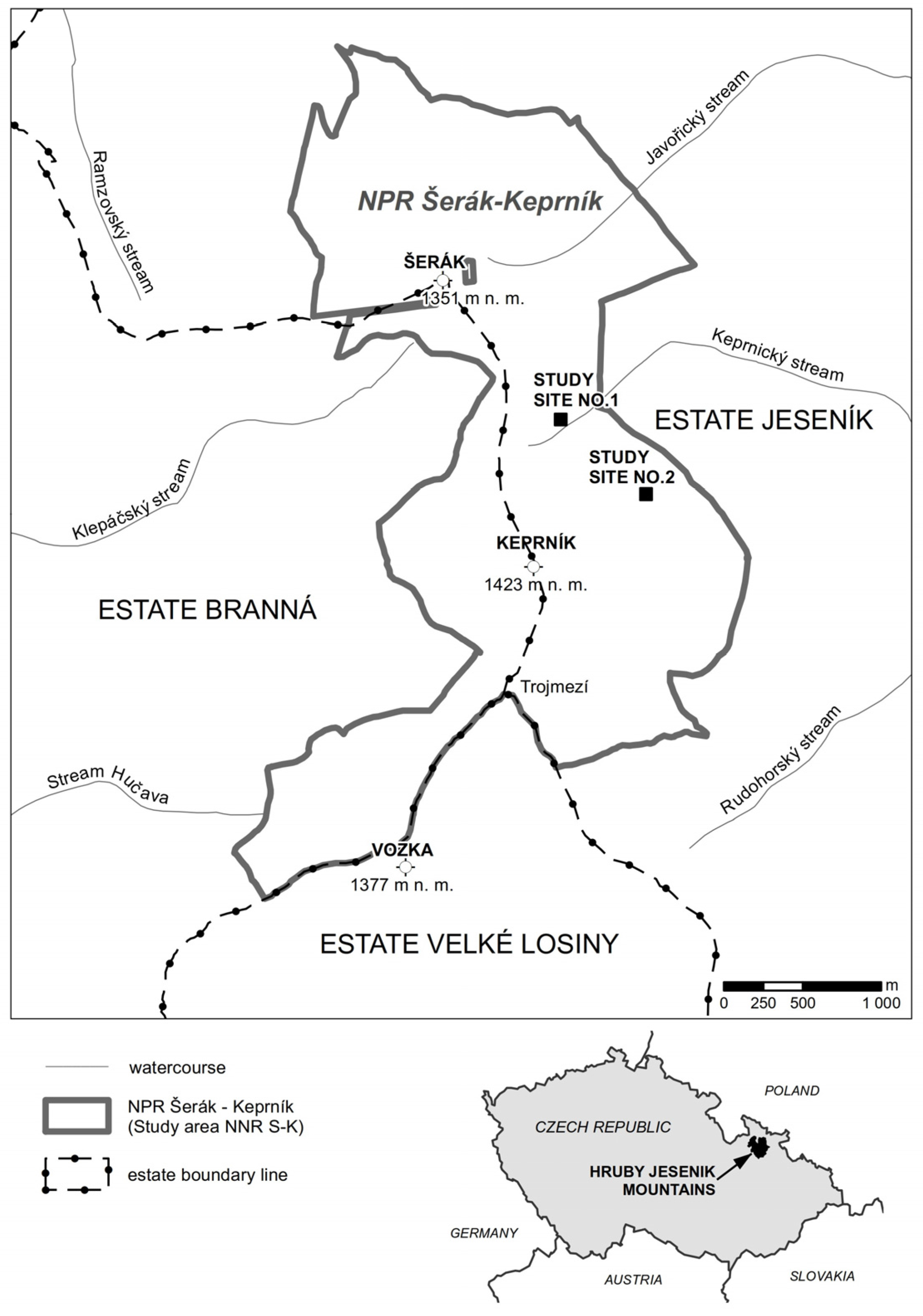
2.1. Study Area

The study area—National Nature Reserve Serak-Keprnik (NNR S-K)—includes ecosystems of mountain forests dominated by Norway spruce in climatic conditions of the eighth forest vegetation zone [20]: the mean temperature of the area is 4.9 °C/year (minimum 1.1 and maximum 7.1 °C/year) and the mean precipitation is 1220.2 mm/year (minimum 800.1 mm/year and maximum 1806.7 mm/year). The spruce forests in the study area extend to the natural tree line; around the three highest peaks in the area (Serak—1351 meter elevation, Keprnik—1423 meter elevation, Vozka—1377 meter elevation) they transition into patches of alpine grassland habitats [21]. The study area is located in the northwestern part of the Hruby Jesenik Mountains [22]. The NNR S-K covers an area of 800.1 ha and belongs to the oldest nature reserves in Central Europe [23]. NNR S-K is part of (1) the core zone of the Jeseniky Mountains Protected Landscape Area (PLA) and (2) the Site of Community Importance (SCI) Keprnik (National code CZ0714075) within the Natura 2000 network [24].
Two study sites (each of them square-shaped 1 ha areas) have been defined in the forests of the study area (Figure 1), representing both types of contemporary forest cover in the reserve: an autochtonous climax mountain Norway spruce forest (study site 1), and an artificially established, alochtonous even-aged spruce forest with a rare occurrence of likely autochthonous spruce individuals (study site 2). According to the management plan for the reserve [25], there are different forest management strategies applied in the study sites, resulting from the categorization of protected areas by the IUCN [26]: In study site 1, non-intervention management is used (IUCN Category Ia—Strict Nature Reserve), whereas in study site 2, a special management practice is applied (IUCN Category VI—VI Protected area with sustainable use of natural resources).
Study site 1 is located at 50°10′43″ N, 17°07′02″ E (1160 meters elevation) on a relatively steep north-west slope with a gradient of 37%. The local bedrock geology consists of Devonian acid gneisses. The soils are shallow and very stony, Cambic Ranker [27] with the moder humus type. The forest cover has a character of natural old-growth mountain Norway spruce forest. The forest vegetation constitutes an unevenly-aged stand of autochthonous Norway spruce with individual fallen rotting spruce trunks and patches of natural regeneration (Table 1).
Study site 2 is located at 50°10′35″ N, 17°07′31″ E (1250 meters elevation) on a north-west slope with a gradient of 22%. The local bedrock geology consists of Devonian acidic schists. The soils are very stony, Podzolic Ranker with the moder humus type. The forest cover has a character of evenly-aged mountain spruce forest, with almost no rotting wood and without natural spruce regeneration (Table 1).
According to the Natura 2000 typology of habitats, both study sites are classified as the Acidophilous Picea forests of the montane to alpine levels (code 9410). According to the Czech national classification of biotopes [28], the study sites belong to the Montane Calamagrostis Norway spruce forests (code L9.1). This habitat type is the subject of protection in the SCI Keprnik.

2.2. History of Forest Ecosystems in the Study Area

There are no specific known historical documents that would map the historical development of the forests in the NNR S-K study area up until 1620. In contrast, there is comprehensive archival documentation in the form of original historical documents deposited in the State Regional Archive in Janovice (the “Branna Estate”, “Jesenik Estate” and “Velke Losiny Estate” collections) and in the State Regional Archive in Brno (“G10” collection) for the period 1621–1947. Since 1947, the forests in both study sites have been owned by the state. Valuable historical data for this period was found in the forest management plans deposited in the archives of the Forest Management Institute in Brandys nad Labem. To analyze the forest development in this period, we also used newer data from the book of management records for the NNR S-K deposited at the administration office of the Jeseniky Mountains PLA.
The identification of historical entries with the current forest stands in the NNR S-K study area was based on the fact that the historical borders of the former private estates—established after 1621—were established along significant natural boundaries (e.g., mountains ridges) and they remained unchanged throughout the existence of the estates until 1947. The mountain forests in today’s NNR S-K were part of three estates (Figure 1). The Branna Estate was owned by the Liechtenstein royal family, the Velke Losiny Estate was originally owned by a Bohemian noble family, the Lords of Zerotin, but later it also became part of the Liechtenstein dominion, and the Jesenik Estate was owned by the Archdiocese of Wroclaw.
The landholding situation in these estates was remarkably stable for several centuries until the Second World War. Shortly after the war, the Czechoslovak government (ruled by the Communist Party since 1948) put the private estates under state ownership. The original estate borders were kept and used for the newly formed state forest enterprises (the forests of the former Branna Estate, Jesenik Estate, and Velke Losiny Estate were taken over by the Forest Enterprise Hanusovice, Forest Enterprise Javornik, and Forest Enterprise Loucna, respectively). This organizational division of the state forests is valid practically to date.
Forests of the Jeseniky Mountains are first mentioned in the “Chronicle of Bohemians” (original Latin name Chronica Boemorum), written by Cosmas of Prague in between the years 1119–1125. The Chronicle suggests that until the 12th century, the mountain forests in the Jeseniky Mountains were part of the “borderline forests”, an unpopulated and forested border of mountain chain that formed a natural defense of the lowland areas of the Bohemian Kingdom, intensely inhabited since the Neolithic period. No major trade route led through the Jeseniky Mountains in the Middle Ages, as there was no suitable mountain pass that would allow crossing the mountain ridge, and one main trade route already established along the western foothills. The first significant colonization efforts of the Jeseniky Mountains associated with anthropogenic impacts on the mountain forests in the form of selective logging date back to the 15th century, as the exploitation of iron ore and gold had started in the peripheral areas of the mountain range and the first mining towns had begun to form along the northern and southern mountain edges.
Since at least the 17th century, the upper parts of the central Jeseniky Mountains above the tree line (formed by natural forest-free areas, alpine grasslands) were used for agricultural purposes (mowing and harvesting of hay, cattle and sheep grazing in summer months). The alpine grasslands of the NNR S-K study area spread out around the Serak, Keprnik, and Vozka mountain peaks (Figure 1). The first literary reference to the agricultural utilization of alpine grasslands in the Loucna Estate (neighboring the Velke Losiny Estate on the south) dates back to 1639, when 14 people were paid to harvest hay in the mountains for two days—this entry, however, relates to the alpine grasslands on the top parts of the Jeseniky Mountains around its highest peak, Praded (1491 m above sea level), lying outside the study area.
The first reference to the haymaking directly in the study area of NNR S-K dates back to 1688. In this year, the accounting books of the Velke Losiny Estate report an income of 2 guldens and 42 kreutzers received from the cotters (peasant farmers) making hay in the high mountains on alpine grasslands. Livestock grazing on the alpine grasslands of the NNR S-K study area is first mentioned in a 1690 entry in the urbarium of the Velke Losiny Estate. Young bullocks used for the grazing were bought in Poland and Hungary and then, after reaching a slaughter weight in the autumn, they were butchered and used by owners of the estate.
By the beginning of the 18th century, alpine grasslands of the Jeseniky Mountains managed by all local estates were entirely used for summer (cattle and sheep) grazing. Grazing sheep stayed on the alpine grasslands from spring until autumn when they were brought to the sheepfolds in the submontane villages. The main center of the animal husbandry in the study area of NNR S-K was located on the site of today’s touristic chalet Svycarna (“Swiss lodge”; the sheep farming was partly managed by experienced shepherds from Switzerland). Grazing likely induced the downward shift of the natural tree line. The grassy pasture areas above the tree line located in the study area presumably reached their greatest extent around the year 1845. It is important to note, however, that the precise determination of the tree line is currently not possible (it is in fact an ecotone strip of varying width) and highly dependent on a subjective approach of a particular forest manager, who may identify the tree line with some distinct terrain feature (e.g., with a hunting pathway along a contour line). Moreover, intentional classification of pastures as forestland could have affected the land tax amount.
The grazing cattle were causing damages to the naturally sparse forest of the tree line areas; therefore, cattle grazing had been increasingly limited, and then completely ended by 1800. Sheep grazing in the study area did not end until 1860, when sheep farming became gradually unreasonable due to an import of cheap wool from Australia to Europe. Scything and haymaking persisted on the top parts of the Jeseniky Mountains, and represented the longest of all agricultural activities. In 1871, however, these activities were forbidden because of damages caused to the forest (mowing along the tree line areas had occasionally caused unintentional damage to tree seedlings, which are especially rare in the local extreme conditions). After the grazing completely ended, the forest ecosystem below the tree line went through a process of gradual regeneration and the former pastures were slowly colonized by new trees. At the turn of the 20th century, the process of a spontaneous reforestation in the study area was supported by an artificial planting of Dwarf Pine, which thrives in these local ecological conditions. This may be the main reason why the alpine grassland habitats today exist only as spatially isolated fragments within the compact stands of Dwarf Pine.
An intensive logging of the mountain spruce forests along the tree line on the territories of all three former estates covering today’s study area began much later (in the 1820s) for two reasons:
(1)
Transportation of wood harvested in the mountains to the valleys was technically and economically feasible by means of river drives on rivers with a steep slope and a sufficient amount of water, but only for a short period of time in the spring after the snow thawing. Some forest areas in the central part of the Jeseniky Mountains were unsuitable for this type of wood transport (due to the impassable terrain combined with the excessive distance to the rivers suitable for river drives) and wood production in such locations was therefore not viable. This was the case for a large part of the forests in today’s NNR S-K.
(2)
Moreover, all three estates in the study area covered an extensive piece of land with an abundance (or even over-abundance) of wood in lower lying, and thus easily accessible, areas. In fact, the Branna Estate and Velke Losiny Estate sold surplus wood from lower altitudes to other areas with high demand for wood (e.g., for ironworks and forges).
At the beginning of the 19th century, other estates in the Jeseniky Mountains hardly offered such favorable conditions for the preservation of natural mountain forests. In reality, large-scale clearcuts in the Bruntal Estate (south of the study area) often extended all the way to the tree line, and thus contributed to its anthropogenically induced downward shift.
In the mid-19th century, forest management plans were formulated for all three estates extending to the territory of the study area. Although the individual management plans varied from each other, they all identically represented a beginning of systematic forest management in the local forests below the tree line.
On the lands of the Branna Estate, forest management was carried out in 1845. All forests, including mountain forests below the tree line, were classified as one management group with a rotation period of 100 years. In 1857, the next forest management introduced clearcuts as a main measure used for artificial forest regeneration. The situation changed in 1877, when mountain forests in the highest altitudes were assigned a new management category with a rotation period of 120 years and prescribed selective cutting. This management category was supposed to have a protection function (protection of soils and lower lying managed forests). The prescribed average wood harvest for these forests was 0.25 m3/ha/year. Identical principles were also implemented in the next forest management plan in 1887. In 1904, an entirely new management approach was introduced for mountain forests: the special management category defined in 1877 was only reserved for forests up to an altitude of 1200 meters above sea level. The remaining forests (172 ha) above this altitude were defined as “virgin-forest reserves” with a prescribed non-intervention management. This change happened for two reasons: first, the Liechtenstein foresters could have wanted to follow the example of their colleagues managing forests of the Schwarzenberg family in southern Bohemia, where the “virgin-forest reserves” had already existed for 50 years; second, it was not quite clear how to manage virgin forests along the tree line, so declaring them reserves could have been the most reasonable solution. In the subsequent years, all forest management plans respected the non-intervention regime prescribed for this special class. These climax spruce forests along the tree line are therefore considered autochtonous and of an exceptionally high ecological value.
Forest management approaches on the lands of the neighboring Velke Losiny Estate were slightly different. As the mountain forests (between the Trojmezi and Vozka peaks) were well accessible for river drives, logging was carried out up to the tree line by the mid-19th century. To improve the conditions for river drives, water reservoirs were constructed on the Derava Voda and Sumiva Desna streams (in 1820 and 1830, respectively). As a result, an extensive area of mountain forest (of an estimated age of 300 years) was clearcut between the years 1820 and 1850 in the valleys of both above-mentioned streams (south and east of the Vozka peak). An apparent change in the forest management approach to mountain forests on this estate took place in 1879, when mountain forests of a total area of 983 ha were classified as special-purpose forests. In the 1933 forest management plan, this class was entitled “forests at high altitudes” and only salvage logging was allowed here. After 1948, spruce forests below the tree line were completely under a non-intervention management plan, and such a management approach is still being implemented up until today.
The Jesenik Estate covered the eastern part of the NNR S-K study area. The mountain spruce forests were classified as a special management group already in 1865, using different management approaches than those for beech forests at lower altitudes. At that time, the mountain forests covered a total of 1477 hectares. The forest management records show that below the alpine grasslands there was a strip of varying width formed by primeval and old-growth forest stands. Over time, a non-intervention regime was implemented for these forests, which was also the most convenient form of management for the local foresters.
In general, the intensity of forest management in the mountain forests below the tree line gradually subsided on all estates in the second half of the 19th century. Among other reasons, the decline was caused by the developing coal mining industry in the Ostrava region. In the mid-19th century, firewood had been slowly replaced by black coal (transported by rail) in the market, and, at the same time, there was an increased demand for long timber wood. River drives from the high areas of the Jeseniky Mountains, however, only allowed transport of short fire wood logs, for which the market demand gradually subsided. For all the above reasons, harvesting fire wood (formerly highly demanded) in the extreme mountain conditions was no longer economically feasible for the forest owners. Towards the end of the 19th century, there were no more prescribed harvests in the protected spruce forests below the tree line on all estates, and all of these forests were under a non-intervention regime. This forest management approach to alpine spruce forests below the tree line in the Jeseniky Mountains has persisted throughout the entire 20th century until today.

2.3. Data Collection, Verification, and Processing

2.3.1. Prediction of Future Development of Forest Ecosystems in the Study Sites

To predict the future forest development in both study sites, we used the SIBYLA growth simulation model [29] modified for the specific conditions of the Czech Republic based on a previously created climatic model [30]. The center of each study site was recorded with Global Position System to allow potential research repetition. Study sites’ boundaries were selected using the Field Map software (IFER-Monitoring and Mapping Solutions Ltd., Jílové u Prahy, Czech Republic). The following parameters were measured: diameter of the tree trunk at 1.3 m (diameter at breast height, DBH), total height of the tree (m), and height of green tree top setting; social position was also determined. All trees with DBH wider than 5 cm were located and marked in a rectangular coordinate system. We employed the dendrometric measurements from both study sites to create stand height curves, using the non-linear Naeslund regression height function.
There is not a predicted shift of forest vegetation zone under climate change in the study sites during the future 50 years [31]. Thus, the growth simulation model does not consider climate condition change for both of the study sites in the predicted period.
Although bark beetles have an important role in the montane spruce forest dynamics, there are no sufficiently large areas of montane climax spruce forests in region of the Hruby Jesenik Mountains which could enable us to consider spontaneous forest ecosystem development under natural dynamics with bark beetles as a driver. Thus, the forest and conservation nature authorities do not support the idea of free activity of bark beetles in the Protected Landscape Area Jeseniky. Occurrence of bark beetles is therefore actively damped in the frame of integrated forest protection. Therefore, growth in the simulation model does not consider using bark beetles in the study sites.
Bark beetle and anthropogenic climate change are two factors that can have significant impacts on forest growth at both study sites for the 50-year planning horizon set in this analysis. Both of these factors are not included in SIBYLA because: (1) the bark beetle impacts are minimized by the management control actions under the forest conservation authorities, and (2) the estimated impacts of anthropogenic climate change on forest ecosystems shift for the 50-year planning horizon is minor [31].
In 2014, we carried out visualization and simulation of the future forest development under a non-intervention management (i.e., spontaneous forest development) for both study sites (1 and 2) using the SIBYLA growth simulation model. In addition, we carried out a simulation of the future forest development under a special management (underplanting) for study site 2. For new generation of underplanting we assume that it will not be destroyed by deer grazing, because of individual protection against browsing (plastic tubes or fencing made of galvanized wire). The results of unpublished research from the National Nature Reserve Serak-Keprnik study area [32] showed that natural regeneration of Norway spruce in the study area was not significantly limited by browsing. The growth simulations were based on a mortality model consisting of two components: probability of tree necrosis [33] and competition threshold [34]. We simulated future forest development for 25 and 50 years. For both study sites we predicted changes in tree diameter diversity of the spruce stands (excluding individuals originating from natural regeneration) and changes in the number of trees. Further, we evaluated the development of tree species composition, representation, and horizontal and vertical structure using the Clark-Evans aggregation index [35] and the standardized Arten-profile index [36] as a relative rate of diversity. The Clark-Evans index deals with horizontal structure of forest ecosystem and is derived from all distances between the two nearest neighbors (ri), number of trees in the plot (N), plot area (p), and the perimeter of the plot (u):
R = 1 N · i = 1 N r i 0.5 · p N + 0.0514 · u N + 0.041 · ( u N ) 3 2
The range of the index is from 0 to 2.15. The value 0 indicates an aggregated structure (i.e., the trees are aggregated in clusters). The value 1 represents a complete random distribution of trees in the plot area (i.e., Poisson distribution), while the value 2.15 stands for the regular tree distribution in the plot (in hexagonal spacing).
The Arten-profile index deals with vertical structure and is calculated using the basal area of ith tree species in jth stand layer (pij):
A P i = i = 1 m j = 1 3 ( p i j · ln ( p i j ) ) ln ( 3 · m )
The first layer in the stand is composed of the trees with heights above 80% of the maximum height in the stand. The second layer consists of the trees with heights lower than 80% and higher than 50% of the maximum height. The index fluctuates between 0 and 1. Higher index values indicate more diverse vertical structures. If the index exceeds the value 0.9, the stand can be considered to have the selection forest structure.

2.3.2. Linking Historical Research with the Growth Simulation Model to Assess Forest Management Practices in the Study Sites

The assessment of forest management practices currently implemented in both study sites is based on combining research of the historical development of the studied ecosystem and interpretation of future development of main edificators predicted by the growth simulation model. The historical research helps to objectively explain the current state of the forest ecosystem determined by the forest management and other human activities carried out in the study sites. The growth simulation model of future forest development predicts the structure of woody vegetation over defined time periods in the future based on specific management practices delineated in the management plan for the protected areas.
The final synthesis based on the results of both analyses (historical research and growth simulation) allows for the assessment of whether the spontaneous (succession) development of the ecosystem resulting from the current forest management plan ensures the maintenance of the existing character of the mountain Norway spruce forest habitat, as defined by Natura 2000, or whether it is appropriate to apply a special management in order to achieve the defined habitat character. This synthesis allows for the suggestion of possible adjustments in the forest management plan in order to comply with the protected area mission of retaining defined habitat character and biodiversity, as defined by the Habitats Directive [37].

3. Results

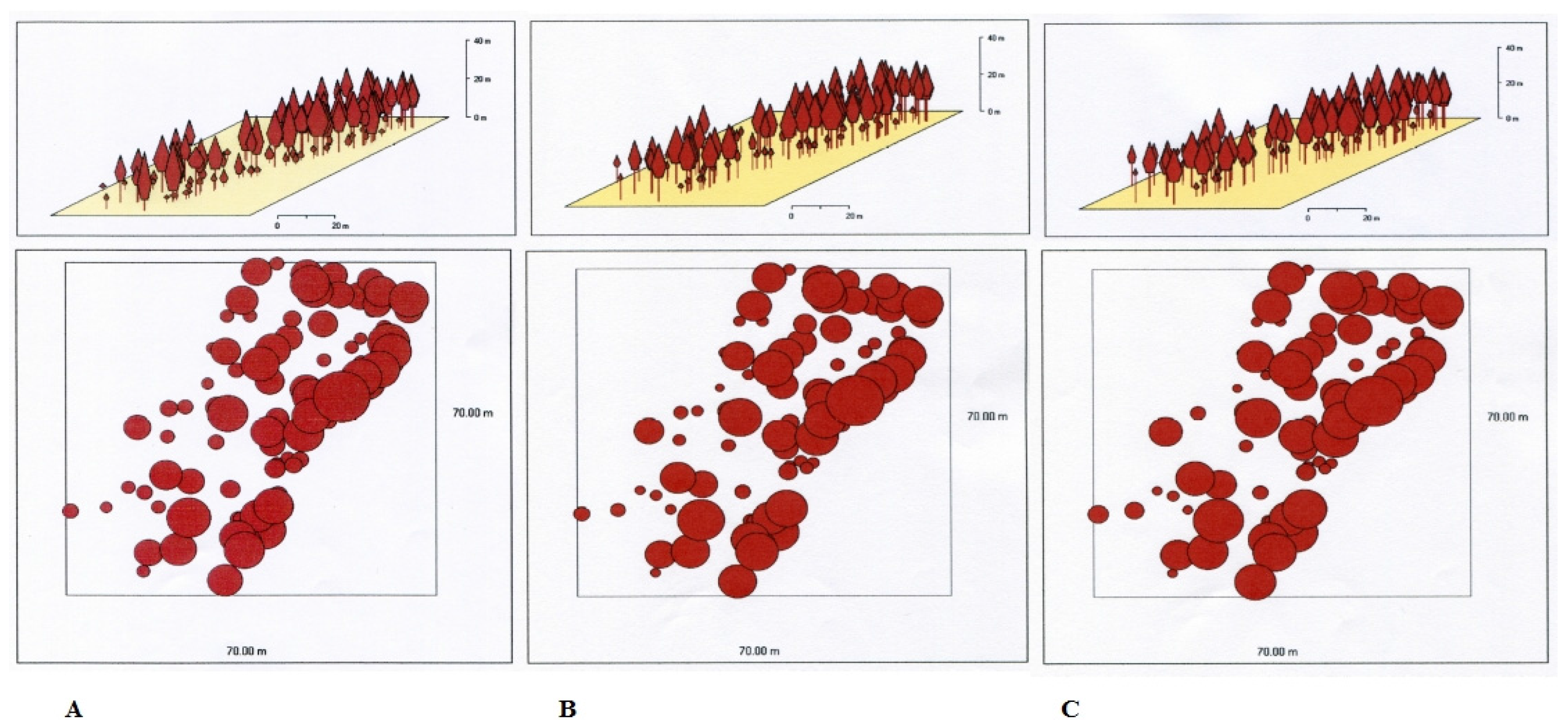
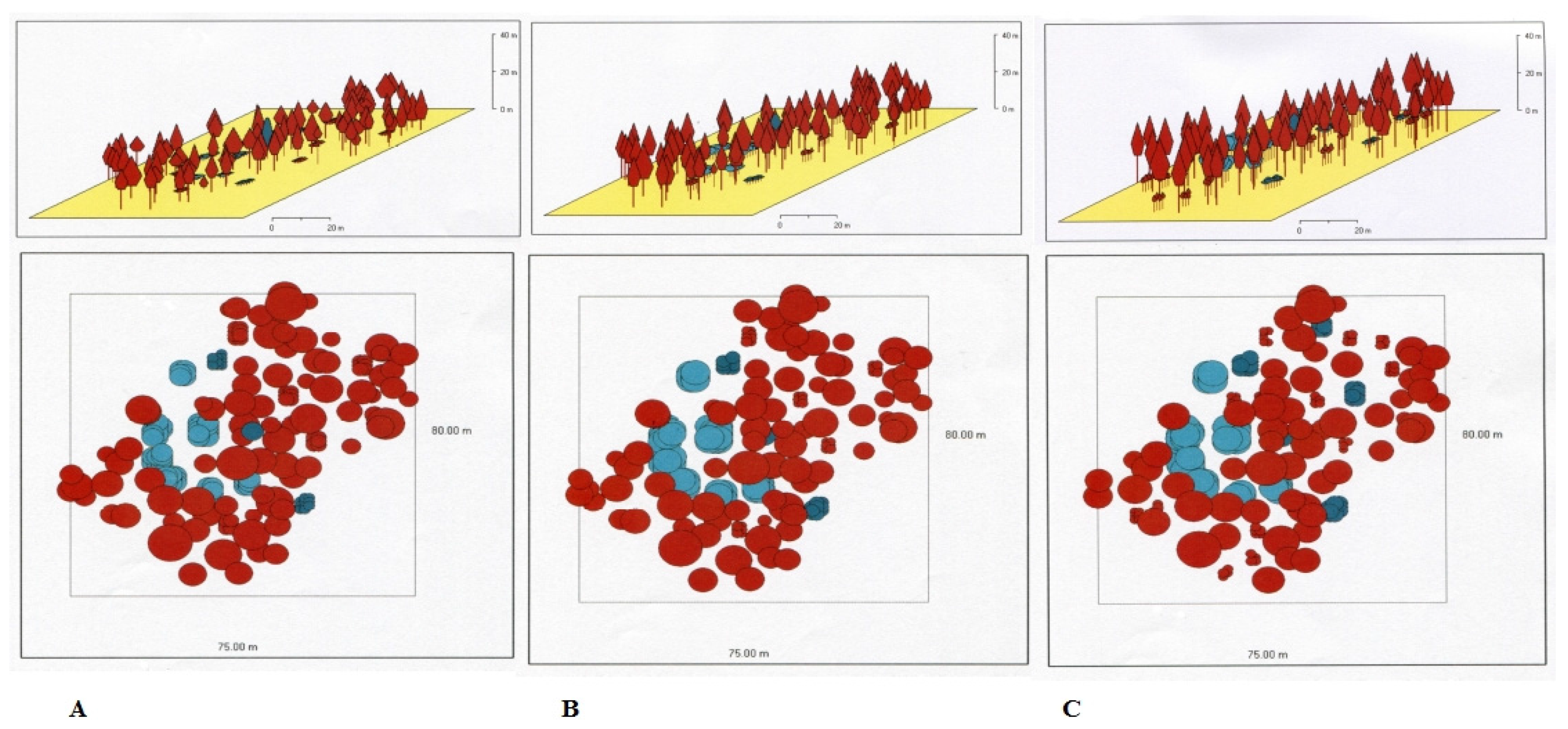
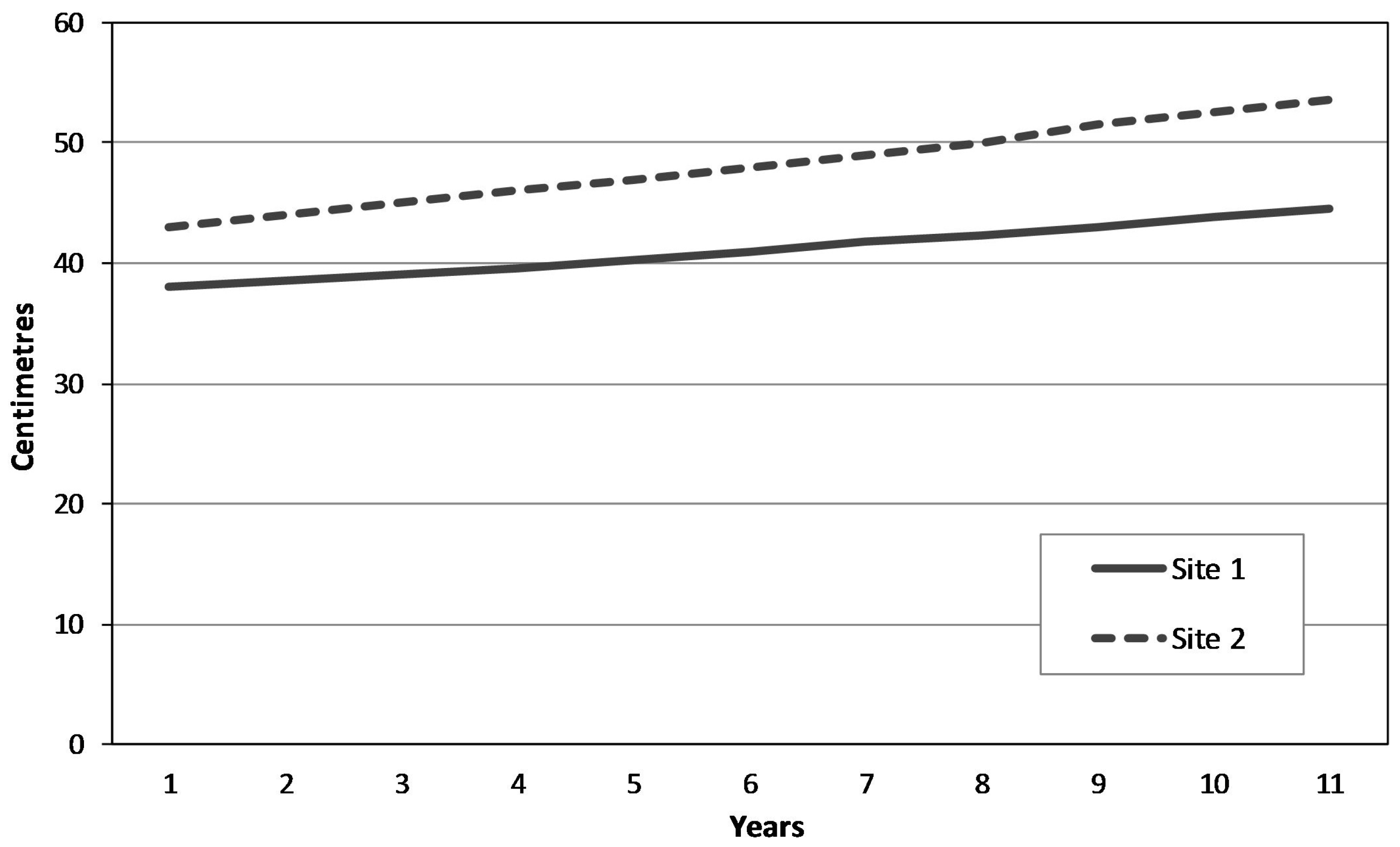
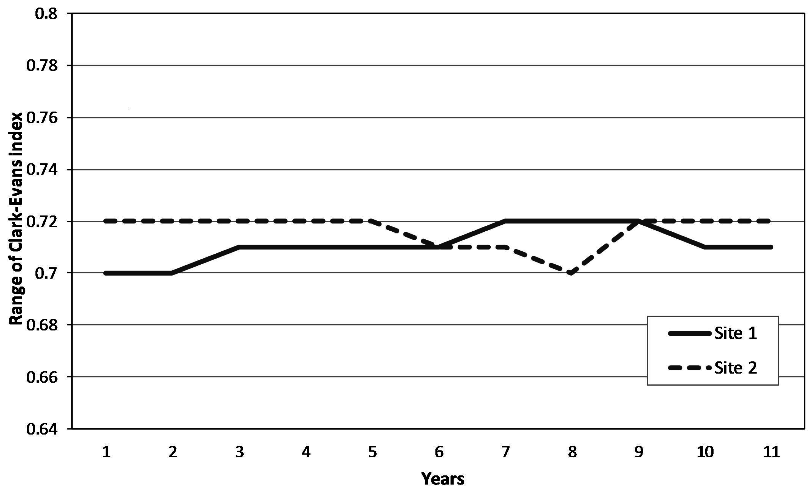
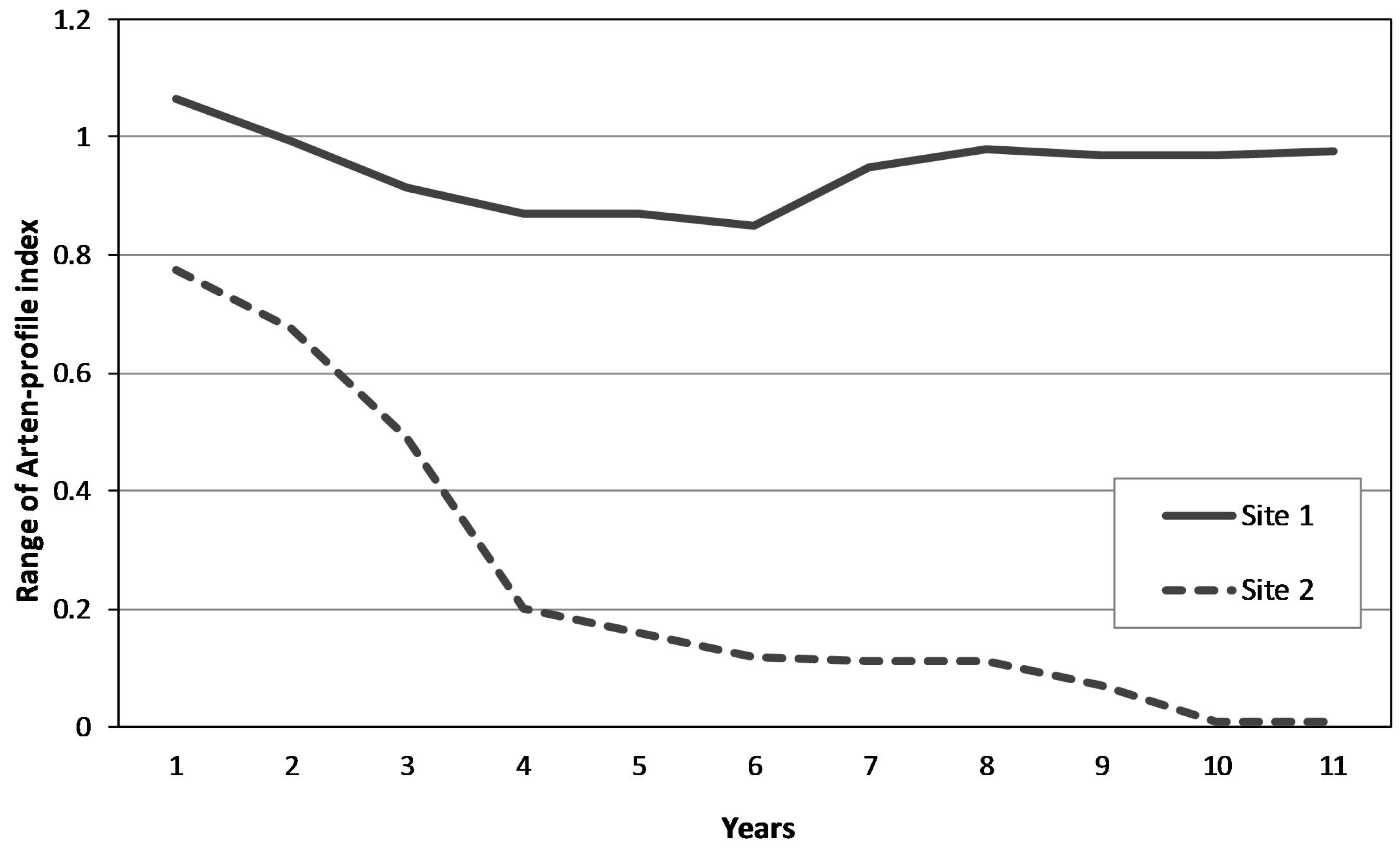
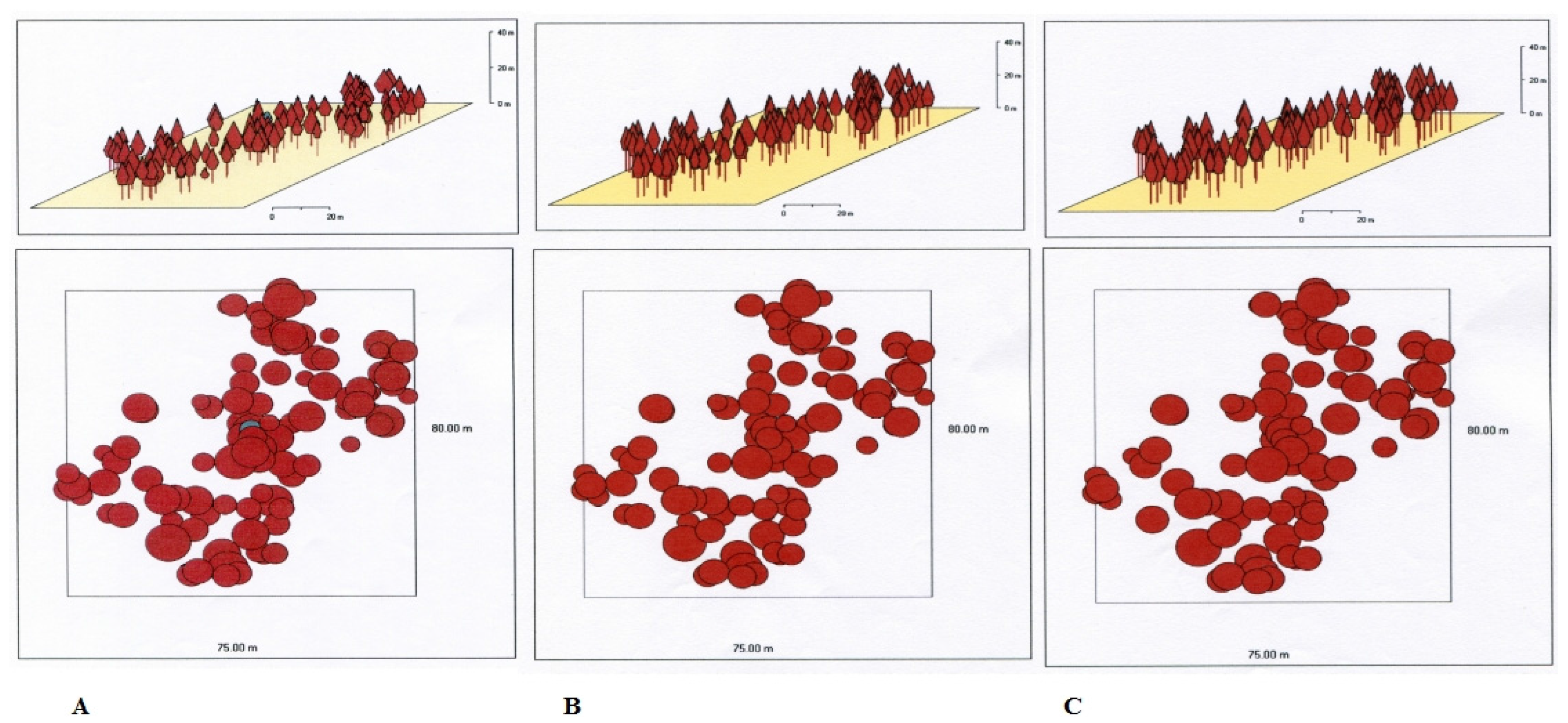
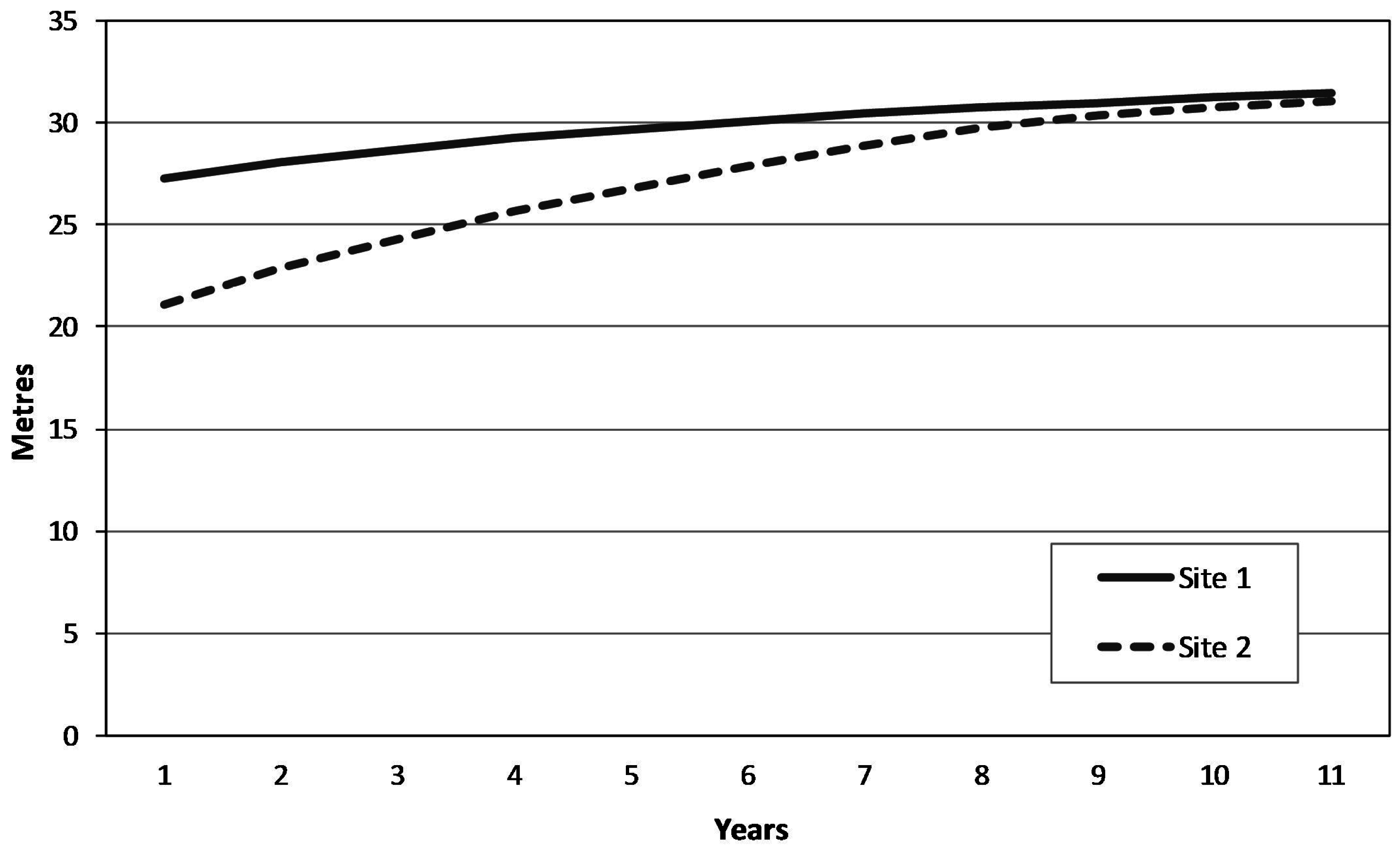
3.1. Predicting the Future Development of the Forest Ecosystem in the Study Area

Visualization of the growth simulation results for the climax mountain Norway spruce forest in study site 1 (Figure 2) shows that the “non-intervention management” does not induce any significant changes in the forest structure (compared to the current state) in either forecast horizons (25 and 50 years). The canopy layer, habitat character, and stocking level do not change significantly over the forecast horizons. Similarly, the growth simulation for an artificial spruce forest under a non-intervention management shows no significant visual changes over the forecast horizons. Because the non-intervention management maintains the dominance of spruce, there are few gaps for interspersed species (e.g., Sorbus aucuparia L.). Thus, the non-intervention management does not result in visually significant changes.
The growth simulation for an artificial Norway spruce forest under a “non-intervention management” in study site 2 is shown in Figure 3 and under a “special management (underplanting)” in Figure 4. The initial state used for the growth simulation is based on an underplanting of spruce and mountain-ash seedlings carried out in vacant gaps in the forest. The goal of underplanting is to diversify the species and age structure of the forest. The growth simulation for the 25-year horizon suggests a positive development trend for the alochtonous Norway spruce monoculture. For the 50-year forecast horizon, the originally vacant gaps are slowly overgrown by the new cohort of trees. Assuming that the new cohort is not significantly impacted by deer grazing, it can constitute a basis for a more diversified forest both, in terms of both species composition and age classes.
Figure 5 shows a graphical representation of the Naeslund height function for both study sites. Forest stands in both study sites have a different spatial structure, which is reflected in the slight phase shift of the height function curve between the two sites. The development of height function shows a trend towards a long-term unification of average forest stand height under a non-intervention management plan. The growth simulation of tree mid-diameter range (Figure 6) under a non-intervention management plan indicates increases occurring concurrently with decreases in the number of trees in the canopy layer. This finding is notable both in terms of nature conservation goals (maintaining the habitat character) and forest management goals for static stability (i.e., resistance) of Norway spruce stands to abiotic factors.
The remarkable stability (i.e., low tendency towards dynamic changes) shown by the growth simulations for both study sites is demonstrated by the Clark-Evans and Arten indexes (Equations (1) and (2)). At both study sites, the horizontal structure of the forest stands measured by the Clark-Evans aggregation index (Equation (1) sows a long-term remarkable stability with a slight tendency towards aggregation (Figure 7). The spatial diversity of the forest stands (Arten-profile index, Equation (2)) shows a trend towards significant divergence (Figure 8).

3.2. Assessment of Management Strategies in the Study Area

The main objective of the management plan for the NNR S-K study area (in compliance with the relevant objectives of the Natura 2000) is to maintain the character of the Montane Calamagrostis Norway spruce forests (habitat type L9.1, as defined by the Natura 2000 classification system). From this perspective, it is notable that the growth simulation model does not assume any significant changes in the character of this habitat type under the non-intervention regime. The growth simulation for the forecast horizon of 50 years shows that the current forest structure, resulting from the historical management, will not change. More, no major trends in the forest development are expected that would significantly affect biodiversity conservation. Based on the synthesis of the historical research and the growth simulation model, we conclude that in the next 50 years the non-intervention forest management, which is based on spontaneous (succession) development of the ecosystem, will uphold the Natura 2000 requirement of protecting this habitat type. Thus, the forest management plan for the study area does not require adjustments to achieve the conservation targets (i.e., maintaining the habitat character and biodiversity).

4. Discussion

The advantage of growth simulation models is that they can be used to reasonably predict the future character of forest stands under variable growth conditions and forest management practices. Growth simulation models represent a promising tool for the sustainable management of forest ecosystems [38]. However, growth models have not yet been fully integrated into forest management practices [39] and are rarely used to assess the forest management practices in protected areas [40]. The authors of this article believe that the combined use of a growth simulation model with the analysis of historical forest developments could be more widely used to assess management plans for protected areas that consist of forest ecosystems [41]. Understanding the historical development of forest stands can significantly improve our understanding of their current state [42]. The multidisciplinary combination of the two different methods (from social and natural sciences) helps to make the assessment of forest management practices in conservation areas more objective, as it allows researchers to predict the development of forest stands under specific management plans in a specific nature reserve. This is particularly important in the Natura 2000 conservation areas [43] because the growth model allows researchers to predict the future development of forest ecosystems based on the conservation goals of a particular forest management practice [44]. Based on the combined results of the growth simulation model and the historical analysis, it is possible to evaluate the current management practice and suggest potential adjustments in the forest management plan in order to comply with the mission of a protected area (i.e., retaining the defined habitat character and biodiversity, as defined by the Natura 2000 European network).
The computed shape of the stand height curves is characteristic only for a particular stand age, while they shift over time [45]. This fact corresponds with our findings for both study sites (Figure 5).
The historical analysis of forest development in the study area suggested that the current structure of forest stands is influenced by the management plan. When changes to the species composition is undertaken in order to meet conservation objectives, additional efforts are required to manage the opened gaps due to historical anthropogenic activities. One such effort includes the underplanting of interspersed species that have been removed by historical anthropogenic activities. The growth simulation model for study site 2 under a special management plan (aimed at increasing both the species and spatial structure diversity of the forest ecosystem) also indicates that this strategy is potentially suitable for the alochtonous spruce forest stand of the Natura 2000 site. The main objective of the management plan for the NNR S-K study area (in compliance with the relevant objectives of the Natura 2000) is to maintain the character of the forest habitat type. The long-term spontaneous development of forest ecosystems in the study area will lead to the creation of valuable habitats for numerous endangered species [46]. As the non-intervention forest management undoubtedly contributes to an increase of dead wood material in the ecosystem, it will affect the biodiversity of organisms depending on various forms of decomposing wood and dying old trees [47]. A gradual increase in dead wood biomass over time (fallen spruce trees on the ground) will likely lead to the promotion of the natural regeneration of Norway spruce, as Norway spruce seedlings in mountain areas grow best on decaying trunks of dead trees [48]. This fact is well documented by the current structure of the autochtonous Norway spruce forest on study site 1, with a clear concentration of certain tree groups in rows, which may indicate that in the past seedlings successfully grew on fallen spruce trees.
In considering growth related research at the stand level, the minimum tree number per plot ranges from 40 to 80 trees depending on the experimental targets and site conditions [49]. The expected tree number in relation to size of measurement area and age of Norway spruce are included in the Norway spruce yield tables [50]. From this perspective, it is notable that the growth simulation model does not assume any significant changes in the character of this habitat type in study site 1 under the non-intervention regime for the 50-year forecast horizon. Size sampling in this study based on these tables for both study sites is deemed to be sufficient. Similar sampling sizes were used in other studies with similar experimental questions [51,52].

5. Conclusions

This paper presents the results of a multidisciplinary research project on a mountain spruce forest ecosystem within the European temperate zone. The research is based on combining the investigation of the historical development of the forest ecosystem, an analysis of its current state, and predictions of future dynamics using a forest growth simulation model. The historical investigation revealed major anthropogenic impacts on forests in the study area, in spite of the extreme (both in terms of productivity and climate) mountain conditions just below the tree line.
Future growth changes of the forest ecosystem will be important in terms of biodiversity protection, because long-term spontaneous development of forest ecosystems contributes to the creation of habitats (e.g., decaying wood) that are valuable for a number of endangered species and necessary for natural generative Norway spruce regeneration.
The studied forest ecosystem is part of the European network of natural protection areas—Natura 2000. The results showed that the non-intervention management for the mountain Norway spruce forest in the next 50 years complies with the Natura 2000 requirements to maintain the existing character of the habitat.
This multidisciplinary research approach helps to make the assessment of forest management (in any geographical and environmental conditions) more objective, provided that basic historical and dendrometric data about the studied forest ecosystem are available. The application of this multidisciplinary approach is therefore particularly appropriate for assessing the suitability of selected management strategies in protected areas. The results of this study suggest that combining research on historical development with a forest growth simulation can be used as a suitable decision-support tool to assess management practices for forest habitats in protected areas.

Acknowledgments

This study was conducted with the financial support of the “Cultural landscape of Olomouc Archdiocese—research, presentation and management” grant as a part of the NAKI II program of the Ministry of Culture of the Czech Republic. The authors thank the Forest Management Institute in Brandys nad Labem and the Protected Landscape Area Jeseniky Mountains Administration Office for providing archive documents for the National Nature Reserve Serak-Keprnik. The authors also thank the anonymous reviewers for their comments and recommendations. The authors are grateful to Jason Prince for language correction of the manuscript.

Author Contributions

I.M., J.S., and K.R. designed the study, I.M., J.S., V.P., and J.B. conducted the fieldwork, I.M., K.R., and H.K. did historical research, V.P. and J.B. did most of the data-analysis, I.M. wrote the manuscript and supervised the research.

Conflicts of Interest

The authors declare no conflict of interest. The founding sponsor had no role in the design of the study, in the collection, analyses, or interpretation of data and in the writing of the manuscript.

References

  1. Bohn, U.; Neuhausl, R.; Gollub, G.; Hettwer, C.; Neuhauslova, Z.; Schluter, H.; Weber, H. Map of the Natural Vegetation of Europe. Scale 1:2,500,000; Landwirtschaftsverlag: Munster, Germany, 2002. [Google Scholar]
  2. United Nations. Global Forest Resources Assessment 2010; Main Report; FAO UN: Rome, Italy, 2010; pp. 12–14. [Google Scholar]
  3. Strengbom, J.; Dahlberg, A.; Larsson, A.; Lindelow, A.; Sandstrom, J.; Widenfalk, O.; Gustafsson, L. Introducing intensively managed spruce plantations in Swedish forest landscapes will impair biodiversity decline. Forests 2011, 2, 610–630. [Google Scholar] [CrossRef]
  4. Pretzsch, H. Diversity and productivity in forests. In Forest Diversity and Functions. Ecological Studies; Scherer-Lorenzen, M., Korner, C., Schulze, E.D., Eds.; Springer: Berlin, Germany, 2005; Volume 176, pp. 41–64. [Google Scholar]
  5. Kulhavy, J. A new concept in sustainable forest management—The need for forest ecosystem and landscape research. J. For. Sci. (Prague) 2004, 50, 520–525. [Google Scholar]
  6. Pretzsch, H. Forest Dynamics, Growth and Yield; Springer: Heidelberg, Germany, 2010; pp. 423–552. [Google Scholar]
  7. Spathelf, P. Reconstruction of crown length of Norway spruce (Picea abies (L.) Karst.) and Silver fir (Abies alba Mill.)—Technique, establishment of sample methods and application in forest growth analysis. Ann. For. Sci. 2003, 60, 833–842. [Google Scholar] [CrossRef]
  8. Zielewska-Buttner, K.; Adler, P.; Ehmann, M.; Braunisch, V. Automated detection of forest gaps in spruce dominated stands using canopy heigh models derived from stereo aerial imagery. Remote Sens. 2016, 8, 175. [Google Scholar] [CrossRef]
  9. Angelstam, P.; Persson, R.; Schlaepfer, R. The sustainable forest management vision and biodiversity—Barriers and bridges for implementation in actual landscapes. Ecol. Bull. 2004, 51, 29–49. [Google Scholar]
  10. Ihne, H.; Spathelf, P. Introduction: Some basic remarks on sustainable forest management, environment and global ethics. In Sustainable Forest Management in Changing World: A European Perspective; Spathelf, P., Ed.; Springer: New York, NY, USA, 2010; Volume 19, pp. 1–7. [Google Scholar] [CrossRef]
  11. Garamvoelgyi, A.; Hufnagel, L. Impacts f climate change on vegetation distribution no.1. Climate change induced vegetation shifts in the Palearctic region. Appl. Ecol. Environ. Res. 2013, 11, 79–122. [Google Scholar] [CrossRef]
  12. Senfelder, M.; Treml, V.; Madera, P.; Volarik, D. Effects of prostrate dwarf pine on norway spruce clonal groups in the treeline ecotone of the Hruby Jesenik Mountains, Czech Republic. Arct. Antarct. Apline Res. 2014, 46, 430–440. [Google Scholar] [CrossRef]
  13. Svoboda, M.; Janda, P.; Nagel, T.A.; Fraver, S.; Rejzek, J.; Bace, R. Disturbance history of an old-growth sub-alpine Picea abies stand in the Bohemian Forests, Czech Republic. J. Veg. Sci. 2012, 23, 86–97. [Google Scholar] [CrossRef]
  14. Hresko, J.; Petrovic, F.; Misovicova, R. Mountain landscape archetypes of the Western Carpathians (Slovakia). Biodivers. Conserv. 2015, 24, 3269–3283. [Google Scholar] [CrossRef]
  15. Schultze, J.; Gartner, S.; Bauhus, J.; Meyer, P.; Reif, A. Criteria to evaluate the conservation value of strictly protected forest reserves in Central Europe. Biodivers. Conserv. 2014, 23, 3519–3542. [Google Scholar] [CrossRef]
  16. Jongman, R.H.G. Nature conservation planning in Europe: Developing ecological networks. Landsc. Urban Plan. 1995, 32, 169–183. [Google Scholar] [CrossRef]
  17. Miko, L. Nature and landscape protection in the European context. In Nature and Landscape Protection in the Czech Republic; Machar, I., Drobilova, L., Eds.; Palacky University: Olomouc, Czech Republic, 2012; Volume 1, pp. 43–49. [Google Scholar]
  18. Brukas, V.; Sallnas, O. Forest management plan as a policy instrument: Carrot, stick or sermon? Land Use Policy 2012, 29, 605–613. [Google Scholar] [CrossRef]
  19. Gotmark, F. Habitat management alternatives for conservation forests in the temperate zone: Review, synthesis, and implications. For. Ecol. Manag. 2013, 306, 292–307. [Google Scholar] [CrossRef]
  20. Macku, J. Climatic characteristics of forest vegetation zones of the Czech Republic. J. Landsc. Ecol. 2014, 7, 39–48. [Google Scholar] [CrossRef]
  21. Jenik, J. Alpine grasslands of the Giant Mountains, Kralicky Sneznik Mountains and Jeseniky Mountains; Academy of Science: Prague, Czech Republic, 1961; pp. 1–132. [Google Scholar]
  22. Demek, J.; Mackovcin, J. Mountains and Lowlands. Geographic Lexicon of the Czech Republic; Nature Conservation Agency: Prague, Czech Republic, 2006; pp. 120–128. [Google Scholar]
  23. Andreska, J. History of forests and forest management in the Czech Republic. In Nature and Landscape Protection in the Czech Republic; Machar, I., Drobilova, L., Eds.; Palacky University: Olomouc, Czech Republic, 2012; Volume 1, pp. 232–245. [Google Scholar]
  24. Skokanova, H.; Eremiasova, R. Landscape functionality in protected and unprotected areas: Case studies from the Czech Republic. Ecol. Inform. 2013, 14, 71–74. [Google Scholar] [CrossRef]
  25. Machar, I. Management and Conservation Plans for Forests. Ph.D. Thesis, Mendel University, Brno, Czech Republic, 2002. [Google Scholar]
  26. Dudley, N. Guidliness for Aplying Protected Area Management Categories; IUCN: Gland, Switzerland, 2008; pp. 8–11. [Google Scholar]
  27. World reference base for soil resources. In International Soil Classification System for Naming Soils and Creating Legends for Soil Maps; Food and Agriculture Organization of the United Nations: Roma, Italy, 2015; pp. 1–203.
  28. Chytry, M.; Kucera, T.; Koci, M.; Grulich, V.; Lustyk, P. Habitat Catalogue of the Czech Republic; Nature Conservation Agency: Prague, Czech Republic, 2010; pp. 341–342. [Google Scholar]
  29. Fabrika, M.; Dursky, J. Implementing Tree Growth Models in Slovakia. In Sustainable Forest Management. Growth Models for Europe; Hasenauer, H., Ed.; Springer: Dordrecht, The Netherlands, 2006; pp. 315–341. [Google Scholar]
  30. Simon, J. Method of creation of forest management plan based on analyse of imaging. In Management of Natural Forests; Vacek, S., Ed.; Lesnicka Prace: Kostelec nad Cernymi Lesy, Czech Republic, 2007; pp. 138–140. [Google Scholar]
  31. Vlckova, V.; Bucek, A.; Machar, I.; Danek, T.; Pechanec, V.; Brus, J.; Kilianova, H. The application of geobiocoenological landscape typology in the modelling of climate change implications. J. Landsc. Ecol. 2015, 8, 69–81. [Google Scholar]
  32. Cermak, P.; (Mendel University, Brno, Czech Republic); Mrkva, R.; (Mendel University, Brno, Czech Republic). Personal communication, 2014.
  33. Dursky, J. Modellierung der Absterbeprozesse in Rein—Und Mischbestanden aus Fichte und Buche. Allgemeine For. Und Jagtzeitung 1997, 168, 131–134. [Google Scholar]
  34. Pretzsch, H. Stand denzity and growth of Norway spruce (Picea abies (L.) Karst.) and European beech (Fagus sylvatica L.). Evidence from long-term experimental plots. Eur. J. For. Res. 2005, 124, 193–205. [Google Scholar] [CrossRef]
  35. Clark, P.J.; Evans, F.C. Distance to nearest neighbour as a measure of spatial relationship in populations. Ecology 1954, 35, 445–453. [Google Scholar] [CrossRef]
  36. Pretzsch, H.; Biber, P.; Dursky, J.; Von Gadow, K.; Hasenauer, H.; Kandler, G.; Kenk, K.; Kublin, E.; Nage, J.; Pukkala, T.; et al. Recommendations for standardized documentation and further development of forest growth simulators. Forstwiss. Cent. 2002, 121, 138–151. [Google Scholar] [CrossRef]
  37. Roth, P. European Union Legislation on Nature Protection (Directive 79/409/EEC, Directive 92/43/EEC, Comission Decision 97/266/EC); Ministry of Environment: Prague, Czech Republic, 2003; pp. 18–22.
  38. Simon, J.; Machar, I.; Bucek, A. Linking the historical research with the growth simulation model of hardwood floodplain forests. Pol. J. Ecol. 2014, 62, 273–288. [Google Scholar] [CrossRef]
  39. Porte, A.; Bartelink, H.H. Modelling mixed forest growth: A review of models for forest management. Ecol. Model. 2002, 150, 141–188. [Google Scholar] [CrossRef]
  40. Sodtke, R.; Schmidt, M.; Fabrika, M.; Nagel, J.; Dursky, J.; Pretzsch, H. Anwendung und Einsatz von Einzelbaummodellen als Komponenten von entscheidungsunterstutzenden Systemen fur die strategische Forstbetriebsplannung. Forstarchiv 2004, 75, 51–64. [Google Scholar]
  41. Idle, E.T.; Bines, T.J.H. Management Planning for Protected Areas; Eurosite: Peterborough, UK, 2005; pp. 86–144. [Google Scholar]
  42. Honnay, O.; Verheyen, K.; Bossuyt, B.; Hermy, M. Forest Biodiversity: Lessons from History to Conservation; CABI Publishing: Wallingford, UK, 2004; pp. 333–358. [Google Scholar]
  43. Parviainen, J.; Frank, G. Protected forests in Europe approaches-harmonising the definitions for international comparison and forest policy making. J. Environ. Manag. 2003, 67, 27–36. [Google Scholar] [CrossRef]
  44. Villard, M.A.; Jonsson, B.G. Setting Conservation Targets for Managed Forest Landscapes; Cambridge University Press: New York, NY, USA, 2009; pp. 384–411. [Google Scholar]
  45. Laar, A.; Akca, A. Forest Mensuration; Springer: Dordrecht, The Netherlands, 2007; pp. 360–383. [Google Scholar]
  46. Sebkova, B.; Samonil, P.; Janik, D.; Adam, D.; Kral, K.; Vrska, T.; Hort, L.; Unar, P. Spatial and volume patterns of an unmanaged submontane mixed forest in Central Europe: 160 years of spontaneous dynamics. For. Ecol. Manag. 2011, 262, 873–885. [Google Scholar] [CrossRef]
  47. Svoboda, M.; Fraver, S.; Janda, P.; Bace, R.; Zenahlikova, J. Natural development and regeneration of a Central European montane spruce forest. For. Ecol. Manag. 2010, 260, 707–714. [Google Scholar] [CrossRef]
  48. Senfelder, M.; Madera, P. Population Structure and Reproductive strategy of Norway spruce (Picea abies L. Karst) above the Former Pastoral Timberline in the Hruby Jesenik Mountains, Czech Republic. Mt. Res. Dev. 2011, 31, 131–143. [Google Scholar] [CrossRef]
  49. Pretzsch, H. Forest Dynamics, Growth and Yield; Springer: Heidelberg, Germany, 2010; pp. 126–127. [Google Scholar]
  50. Assmann, E.; Franz, F. Vorlaufige Fichten-Ertragstafel fur Bayern; Institut für Ertragskunde der Forstlichen Forschungsanstalt: Munchen, Germany, 1963; pp. 98–104. [Google Scholar]
  51. Pretzsch, H.; Schutze, G. Effect of tree species mixing on the size structure, density, and yield of forest stands. Eur. J. For. Res. 2016, 135, 1–22. [Google Scholar] [CrossRef]
  52. Caicoya, A.T.; Kugler, F.; Pretzsch, H.; Papathanassiou, K. Forest vertical structure characterization using ground inventory data for the estimation of forest aboveground biomass. Can. J. For. Res. 2016, 46, 25–38. [Google Scholar] [CrossRef]
Figure 1. Location of the study area National Nature Reserve Serak-Keprnik in the Czech Republic and location of the study sites 1 and 2 in the frame of the study area.
Forests 07 00285 g001
Figure 2. Growth simulation model for study site 1 (autochthonous mountain Norway spruce forest) under a non-intervention management: status quo (A), and visualization of the future forest development for the period of 25 years (B) and 50 years (C). Red = Picea abies.
Forests 07 00285 g002
Figure 3. Growth simulation model for study site 2 (alochtonous Norway spruce forest) under a non-intervention management: status quo (A), and visualization of the future forest development for the period of 25 years (B) and 50 years (C). Red = Picea abies, blue = Sorbus aucuparia.
Forests 07 00285 g003
Figure 4. Growth simulation model for study site 2 (alochtonous Norway spruce forest) under a special management (i.e., underplanting) plan: status quo (A), and visualization of the future forest development for the period of 25 years (B) and 50 years (C). Red = Picea abies, blue = Sorbus aucuparia.
Forests 07 00285 g004
Figure 5. Naeslund height function for both study sites.
Forests 07 00285 g005
Figure 6. Prediction of changes in the tree mid-diameter range (cm) of the Norway spruce stands for both study sites.
Forests 07 00285 g006
Figure 7. Prediction of the Clark-Evans aggregation index values for both study sites.
Forests 07 00285 g007
Figure 8. Prediction of the standardized Arten-profile index values for both study sites.
Forests 07 00285 g008
Table 1. Dendrometric characteristics of forest stands in study sites 1 and 2 (study area National Nature Reserve Serak-Keprnik (NNR S-K)).
Study SiteProportion of Spruce (%)Average Stand Height (m)Median Diameter at Breast Height (cm)Stem Sanding Volume (m3·ha−1)Crown Canopy Average (%)StockingYield Level of SpruceAge of Dominant Forest Tree Layer (Years)
1100223227270822170
2100273932790926140

