Article

Cost-Effectiveness of Fuel Removals in Mediterranean Wildland-Urban Interfaces Threatened by Wildfires

1
Department of Agriculture and Environmental Sciences, University of Bari “A. Moro”, Via Amendola 165/A, Bari 70126, Italy
2
Department of Agriculture, University of Sassari, Via Cristoforo Colombo 1, Nuoro 08100, Italy
3
CGCEO, Michigan State University, East Lansing, MI 48823, USA
*
Author to whom correspondence should be addressed.
Forests 2016, 7(7), 149; https://doi.org/10.3390/f7070149
Submission received: 27 April 2016 / Revised: 14 July 2016 / Accepted: 16 July 2016 / Published: 20 July 2016

Abstract

:
One of the most important environmental issues in Europe is the expansion of wildland-urban interfaces (WUIs) and how this trend may affect the occurrence of wildfires. Land use changes, the abandonment of farmland, and reduced grazing has led to an increase in forested areas with an accumulation and continuity of surface fuels available for combustion. Policies based exclusively on extensive fire suppression have become ineffective in different parts of Europe. To reduce the threat of damaging and costly wildfires, European countries must develop integrated fuel management programs. This approach has proven to be one of the most cost-effective for preventing wildfires and reducing economic loss. To this end, we have conducted a cost-effectiveness analysis to estimate how much fuel must be treated to determine fuel load removals with the lowest cost per hectare of unaffected WUIs threatened by wildfires in southern Italy (Apulia region). The analysis was carried out in three stages: (i) simulation of fire behavior in different fuel load reduction and wind direction scenarios; (ii) estimation of WUIs affected by wildfires within the study landscape; and (iii) the application of a cost-effectiveness ratio. Our results highlight the need to provide a method to evaluate the cost-effectiveness of fuel removal given the increasing number and extent of WUIs in the Mediterranean landscape of Europe. Optimizing the cost-effectiveness analysis of fuel removals offers the basis for appropriately assessing wildfire prevention and budgeting financial resources. Further, this method may be readily applied toward allocating any type of intervention in landscape management.

Graphical Abstract

1. Introduction

In Europe, the last few decades have been characterized by constant land use changes, especially in the Mediterranean region [1,2]. The abandonment of farmland and reduced grazing have led to an increase in forested areas with an accumulation and continuity of surface fuels available for combustion [3,4]. These landscape changes have contributed to a more aggressive spread of large wildfires. Moreover, the proportion of burned areas has continued to grow, causing substantial damage to European economies [5,6]. Therefore, large investments are required to prevent wildfires from spreading, especially in wildland-urban interfaces (WUIs). The European Commission, for instance, invests more than $3.2 billion every year in fire suppression to limit the socioeconomic impacts of wildfires [7,8]. Policies based exclusively on extensive fire suppression have begun to show signs of failing in different parts of Europe [7,9,10]. To reduce the threat of damaging and costly wildfires, European countries must develop integrated fuel management programs for wildfire prevention and mitigation. Fuel management is one of the most effective approaches for preventing wildfires and reducing economic loss [11,12,13,14,15].
Increasing efforts have been made in studying fuel management for wildfire prevention in WUIs. The aim is to demonstrate the effectiveness of different pre- and post-fire fuel management interventions with innovative approaches and views [16,17,18,19,20]. Ager et al. [16] simulated long-term fuel management interventions on a 16,000-ha WUI in Oregon, USA. The simulation models suggested that the area would require repeated thinning over time to reach desired forest density and to reduce crown fire activity. Safford et al. [18] measured wildfire effects on vegetation in treated and untreated areas within the WUIs of Lake Tahoe Basin, California, USA. Their results showed that fuel treatments substantially changed fire behavior and subsequent fire effects on WUIs. Kennedy and Johnson [19] carried out fuel management activities in the forests surrounding WUIs in Arizona, USA. The two authors attempted to create defensible space and safe opportunity for the protection of homes during wildfires. Elia et al. [20] developed a spatial index to determine where and what type of forest areas may be eligible for fuel removal in the WUI areas of southern Europe. By means of this index, the authors attempted to understand which areas require allocation of fuel removals to prevent wildfire occurrence.
The overall findings of the above studies have demonstrated that fuel management does indeed modify wildland fire behavior and its effects on forest and human systems. However, they do not provide a clear link between fuel removal and its cost-effectiveness ratio. In Europe, knowledge is still lacking in regard to this link despite the fact that each year, especially in summer, the problem of wildfires remains dramatically constant [8]. Understanding this relationship may be a support for forest managers to improve efforts in landscape management and in the budgeting of financial resources. In fact, there is worldwide consensus that an increasing amount of funds are required to manage fuels or to prevent wildfires over entire landscapes while the necessary resources are often limited [21,22].
Our investigation aims to evaluate the effectiveness of fuel load removals on WUIs threatened by wildfires in a Mediterranean landscape of Europe. To this end, we conducted a cost-effectiveness analysis (CEA) explaining the benefits arising from unaffected WUI and the lowest cost of fuel load removals required to reduce wildfire severity. Herein, we provide a detailed description of the main steps employed to run the cost-effectiveness analysis, using WUI landscapes located in the province of Taranto (Apulia region) in southern Italy.
The cost-effectiveness ratio is a concept widely used in many research fields. Our results suggest that landscape management, aimed at preventing wildfires in WUIs, should integrate this approach in the context of a broader wildfire management programs. The range of risk-mitigation strategies must be prudently evaluated using the criteria of efficacy and effectiveness; this study is intended to contribute to this area of investigation.

2. Materials and Methods

The cost-effectiveness analysis was carried out in three stages: (1) simulation of fire behavior, in terms of fireline intensity (FLI), in different fuel load reduction and wind direction scenarios across the study landscape; (2) estimation of WUIs affected by wildfires within the study landscape; and (3) application of a cost-effectiveness ratio to determine fuel load removals with the lowest cost per hectare of unaffected WUI.

2.1. Study Landscape

The effects of fuel reduction on WUI were modelled by analyzing wildfire simulations in a WUI landscape, named Ionic Arc, located in southern Italy (Apulia region) in the Province of Taranto (40°28′18″ N 16°56′15″ E) (Figure 1). The Ionic Arc covers more than 2350 ha and the landscape is relatively homogeneous in terms of elevation (<400 m above the sea level) and slope (0%–20%). Twenty percent of the study area is characterized by the conifer Pinus halepensis L. (Aleppo pine) along the coastal areas, the broad-leaved species Quercus ilex L. (holm oak), Q. pubescens L. (downy oak), Q. trojana (Macedonian oak) on the foothills (450 m a.s.l.), and shrubland (also defined as “maquis”) represented by evergreen (sclerophyllous) shrub vegetation. In recent decades, mounting urbanization (>240 inhabitants per km2) and the abandonment of agricultural land have increased the extent of urban areas in this landscape. The Ionic Arc encompasses 29 municipalities that, according to national law (No. 353/2000), must be monitored and mapped annually for wildfire occurrence and spread within the entire landscape. Wildfires are particularly frequent during the summer with the high flux of the local population and tourists and when weather conditions are favorable for their spread. Between 2000 and 2013, approximately 1100 wildfires burned almost 11,600 ha of forests in the study area [23,24].

2.2. Wind Scenarios and Fuel Removals

Three wind direction scenarios and eight levels of fuel reduction (from 10% to 80%) were implemented in a fire behavior simulator to estimate the decrease of FLI across the Ionic Arc. We used three prevailing wind scenarios to evaluate different wind-driven fire behaviors spreading into WUI. This allowed understanding which wind directions mostly affect fire behavior across the landscape, generating the highest FLI values. These directions were selected according to the frequency and effect of the prevailing winds that blow in this landscape. The first two, specifically, have caused extensive damage in the past to forests in the area in extremely dry seasons and when combined with wildfire. Once obtained, these data may be employed to estimate the fuel load removal needed and the associated cost-effectiveness ratio in terms of unaffected WUIs.
FlamMap 5 fire behavior mapping and analysis [25] was used to simulate the propagation and behavior of wildfires within the study landscape for each scenario. Several themes were acquired to obtain the input layers to run the FlamMap 5 simulations. The grid resolution of all spatial information was 20 m.
Weather data (air temperature, relative humidity, wind speed, wind direction, and rainfall) were obtained from the Civil Protection database for the Apulia region. To carry out potential fire behavior simulations we used the extreme weather values of temperature, relative humidity, and wind speed from the last 13-year in southern Italy as well as the three prevailing winds (2000–2013 period). Thus, we simulated the potential fire behavior under extreme weather conditions to evaluate its maximum values in terms of FLI [26]. FLI is predicted (within the WUI cells) by the Minimum Travel Time (MTT) fire spread algorithm and depends on the direction in which the fire encounters a pixel relative to the major direction of spread (i.e., heading, flanking or backing fire), slope, aspect, and elevation [27]. A digital elevation model was used to derive the slope, aspect, and elevation maps. Canopy cover maps were generated by the supervised classification of satellite images provided by Planetek Italia s.r.l. (www.planetek.it/eng).
Ten potential ignition points were randomly selected (Figure 1B) to perform simulations with FlamMap 5 as required by the MTT fire spread algorithm. The ignition points were selected among vegetation cover where high fire risk is due to fuel accumulation. Furthermore, they are close to urban areas as well as roads, power lines, and railway tracks since the study landscape represents a WUI area.
Fire behavior simulations (3 h) were run using two standard fuel models: models n. 1 and n. 5 developed by Anderson [28] for short grass vegetation and short brush, respectively. Three customized fuel models were used and tested to account for the site-specific vegetation cover in the Taranto province. The parameters of these fuel models were derived using data from previous studies conducted on similar vegetation types in the same province by Elia et al. [20] (Table 1).
The sporadic implementation of silvicultural practices (e.g., thinning) without adequate harvesting coupled with the impossibility of using prescribed burning (not allowed in this part of Italy) have led to a considerable and continuous accumulation of dead fuel, especially “flash fuels” which are the primary carrier of surface fires. Therefore, we focused our analysis on the amount of fine dead fuel load potentially removed form forest stands in WUIs, namely 1-h fuel load (1hFL). This type of fuel includes needles, litter, and fine dead stems (<0.6 cm in diameter), which ignite readily and are consumed rapidly under hot and dry weather conditions [29]. Table 2 shows the amount of 1hFL (Mg) for each fuel model in the entire landscape.

2.3. Urban Density Estimation

We employed land-cover data from the regional government on a scale of 1:50,000. These layers define the landscape according to 62 classes. Using FRAGSTATS statistical software, the urban vector layer was processed to obtain urban density. Briefly, the moving window analysis was employed for computing Total Class Area metrics, a measure of landscape composition (see Figure 1A). The output obtained from the analysis is a map of urban zones, with a hectare value corresponding to each urban pixel within the study area. Using FlamMap 5 simulations for each wind scenario, we estimated the amount of urban areas (ha) unaffected by removing dead fuel loads (subsequent decrease of FLI).

2.4. Cost-Effectiveness Analysis

To carry out the cost-effectiveness analysis (CEA), we estimated the amount of investment needed to remove the fine dead fuel load in order to understand the effectiveness of the fuel removal in unaffected WUIs. After conducting a market research, we assessed the cost for removing 1hFL from forests, including labor, transport, and disposal costs, to be €210.50 per ton. The average amount of time estimated to remove 1 ton of dead fuel from the study sites is 1.6 h, with €62.70 being the hourly labor cost, €20.00 the cost of transporting 1 ton of dead fuel to disposal sites within a distance of 100 km from the forest, and €90.30 the cost for disposal. These estimates were verified by comparing them to the costs reported by forest companies operating on the local market [14]. Hence, we calculated how much it costs to remove the fuel load needed to modify fire behavior in terms of FLI. The CEA is represented by the line-line intersection between the decrease of FLI and the increase of unaffected WUIs as a function of fuel removals in three different wind direction scenarios (Figure 2).

3. Results

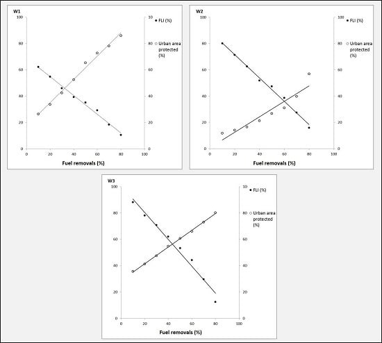
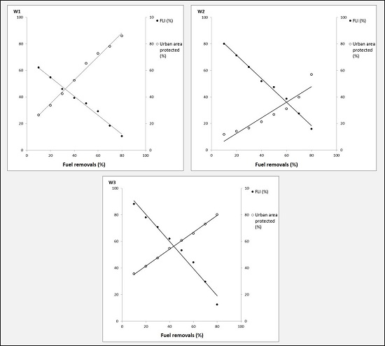
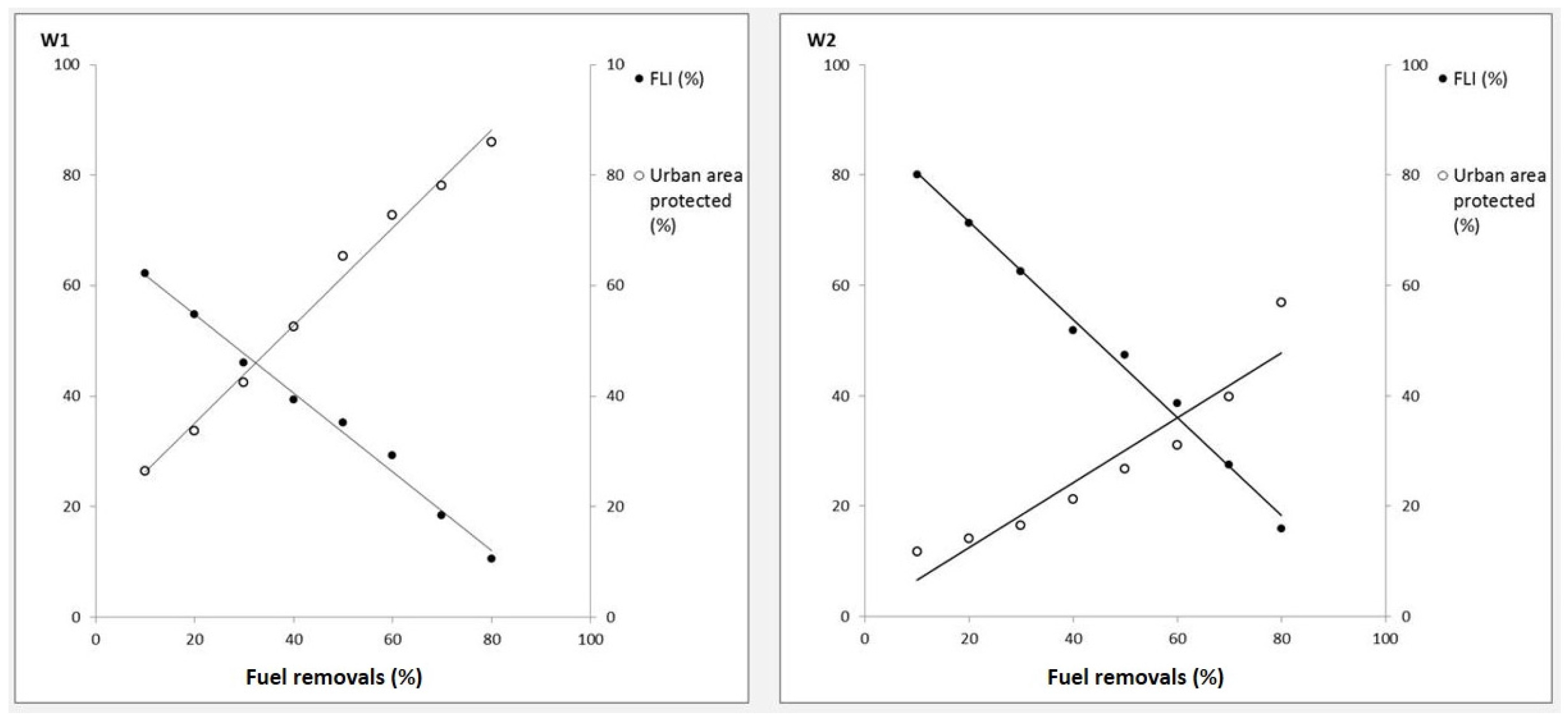
3.1. Fire Behavior Simulations

Fire behavior simulations were performed for each wind direction and fuel removal scenario (W1–W3) to estimate the FLI and affected WUIs within the study area (Table 3). Our findings suggest that the most severe potential FLI (1924.52 kW/m) occurred in W2 compared to the other scenarios. The FLI values ranged from 876 to 1924 kW/m across the wind direction scenarios, with the highest value at W2, and the lowest at W3. As the results show, most FLI values (NoTreat values) exceeded 1700 kW/m, identified by many authors as the threshold value beyond which wildfire suppression by retardant spraying by aerial firefighting aircraft is required [30].
For each fuel removal (FR) treatment, we describe the reduction of FLI. Our observations indicate that the FLI values fell within this specified threshold only when FR4 (40% of fuel reduction) was applied for the W1 and W2 scenarios, and FR2 (20% of fuel reduction) for the W3 scenario. For example, FLI reached 613 and 564 kW/m after FR4 for the W1 and W2 scenarios, and 719 kW/m after FR2 for the W3 scenario. Our results show that after FR1 (10% of fuel reduction), the decrease in FLI differed among wind scenarios. For example, in the W1 and W2 scenarios, after FR1, FLI decreased by 35% to 38% whereas in W3 it decreased by 18%.

3.2. WUIs Affected

By using fire behavior simulations, we were able to estimate how many hectares of WUIs are affected by wildfires, assuming not suppression actions implemented in this free spreading fire. As expected, the amount of hectares decreased as more fuel removal was applied. The total number (ha) of WUIs areas affected by wildfires ranged from 120 to 230 ha across the wind direction scenarios. Our findings suggest that W2 reported the highest value (230 ha) of WUIs areas affected by wildfire compared to the other scenarios. The results also revealed that the total amount of expected hectare loss decreased rapidly as FR1 fuel removal was applied for each wind scenario. For instance, after FR1 the decrease of affected hectares (10% of fuel reduction) reported was 13%, 12%, and 14% for the W1, W2, and W3 scenarios, respectively. The decrease in hectare loss was less relevant from FR2 to FR6 for the W2 compared to W1 and W3 wind scenarios. For example, after FR6 the decrease of affected hectares (60% of fuel reduction) was 31% for the W2 scenario compared to 42% and 50% for the W1 and W3 wind scenarios, respectively.

3.3. Estimating the Cost-Effectiveness Analysis

Figure 2 shows the line-line intersection of the decrease in FLI and the increase of unaffected WUIs area as a function of fuel load removals for three different wind direction scenarios. Based on this analysis, it was possible to estimate the amount of fuel that must be removed in order to determine the lowest cost per hectare of unaffected WUIs areas. The point of intersection indicated the amount of fuel load to be treated for the W1, W2, and W3 wind direction scenarios, with corresponding values of 32%, 60% and 43%, respectively.
Table 4 indicates the amount of fuel load to be removed as suggested by the point of intersection in percentage values. For the W1 wind scenario the amount of fuel load to be treated in the entire study area is 8592 tons (32%). Removing the fuel load allows to potentially reduce fire severity by 46% in terms of FLI and to protect 98.44 ha of WUIs areas affected by fire (projections of the point intersection to the y axis, Figure 2). For the W2 wind scenario the amount of fuel load to be treated is the highest (16,111 tons). Despite great efforts in terms of fuel removal (60% of fuel reduction), this treatment allows to reduce fire severity by 36% and protect up to 83 ha of potential WUIs areas affected by wildfires (projections of the intersection point to the y axis, Figure 2). In the case of the W3 wind scenario, the amount of fuel load to be removed was 11545 tons (43% of fuel reduction) (see Table 4). By removing the fuel load we were able to reduce fire severity by 56%. However, the number of unaffected WUIs areas recorded was the lowest (up to 68 ha).
Based on our market search, we estimated the costs per hectare of fuel load removals for each wind direction scenario (Table 4). For the W1 wind scenario the cost was the lowest (790 €/ha), whereas for the W2 and W3 wind scenarios the costs were higher (1,482 and 1,060 €/ha, respectively).
The cost-effectiveness analyses revealed that with an investment of €1,804,320 it is possible to protect 98.44 ha of WUIs areas (€18,329.13 per hectares of unaffected WUIs areas) and reduce FLI by almost 50%. Despite the most severe fire behavior shown for the W2 wind scenario (see Table 3), an investment of more than €3.3 million are required to protect fewer hectares of WUIs areas (up to 83 ha, €40,784.53 per hectares of unaffected WUIs areas) and to reduce less than 40% of the FLI compared to the W1 scenario. The same holds true for the W3 wind direction scenario where more than €2.4 million are needed to reduce 56% of the FLI and to protect the fewest number of hectares in WUI (up to 68 ha, €35,773.06 per hectares of unaffected WUIs areas).

4. Discussion

Europe and its neighboring countries have witnessed an increasing frequency of extreme wildfire seasons over the past decade [8]. As a result of the increased fuel accumulations and continuity (especially in the southern Mediterranean region) coupled with increasing droughts likely triggered by climate change, wildfires have become severe and their impact on economies continues to grow [5]. The generalized use of predicted effective actions for wildfire mitigation in the literature suggests that economic analysis can provide useful information to support wildfire prevention programs.
Fuel treatments have a significant impact on reducing fire severity and the possible occurrence of extreme wildfires; the higher the percentage of fuel treatment, the greater the effect on reducing FLI. This decreasing trend in FLI is well known in the literature, and our findings are in line with numerous research studies worldwide [31,32,33]. The FLI reduction achieved with fuel load removal affects the possibility of transition from surface fire to the crown fire, in which the fire spread is essentially driven by the wind’s action through tree canopies [34,35].
Therefore, fuel removals can be used as an effective fuel management practice to aid fire suppression policy in European countries of the Mediterranean basin [20]. The problem arises when financial resources are limited and investments need to be quantified (e.g., cost of fuel removal) on the basis of such resources to maximize the resulting benefit. Our study intended to investigate this issue by proposing an approach to identify such an investment from the amount of fuel load to be treated.
Predictions of fire behavior indicate that under a NoTreat scenario wildfires are the least severe. This finding has important implications for WUI landscape management in terms of human protection. There is a need to enhance the prevention phase by implementing fire-prone landscape management interventions. Such management practices (e.g., 1-h fuel load removals) alter fire behavior and result in a two-fold effect: overall, the safeguarding of humans and urban infrastructures from fires, and the preservation of the ecological function of forest ecosystems [36].
Our study developed a method to optimize the cost-effectiveness ratio determining 1-h fuel load reduction with the lowest cost per hectare of unaffected WUIs threatened by wildfires. Given the often-limited budgets available to protect WUIs, this analysis offers a method to efficiently manage the occurrence of future wildfires in the increasing number of WUIs within the Mediterranean landscape of Europe [37].
In the present study, the results of the cost-effectiveness analysis varied in different wind direction scenarios. In fact, despite the constant wind speed during simulations, incoming winds from opposite directions affect wildfire behavior based on topography, slope, and aspect [27]. These observations represented an important first step in evaluating the cost-effectiveness analysis of preventive actions. Considering only one prevailing wind in the simulations would lead to the risk of underestimating the FLI of a fire-prone landscape [38]. Given its geographic position, a WUI landscape may be affected more than others by wildfires of different FLI values. Furthermore, if we had considered only the W3 scenario (315° wind direction), for example, we would have overestimated the budget (35,784.53 €/ha) to protect fewer hectares of WUIs. For this reason, it was important to consider different wind scenarios in our landscape.
Nevertheless, our findings in the Apulia region are of secondary importance to the approach we have devised, since this study has suggested a method for evaluating the lowest cost of fuel load removal per hectare of unaffected WUIs threatened by wildfires. Optimizing the cost-effectiveness ratio provides the basis for appropriately assessing wildfire prevention and suppression activity. This method may be applied regardless of the specific landscape context and/or at multiple scale(s). In our study, for example, it was applied at the landscape scale (e.g., Ionic Arc), but may be implemented at the municipality scale as well. Wildfire risk analysis is a priority that involves many regions worldwide [39] where our method could be used to support landscape management.

5. Conclusions

Assessing fuel treatments plays a key role from the perspective of effective wildfire management programs. In this study, we investigate an important knowledge gap regarding the link between fuel removal and its cost-effectiveness. This is especially important in European countries that are facing economic crisis and the increasing incidence of fires in WUIs.
In nature-based research, where issues such as wildfires and WUIs are dealt with, it is crucial to optimize available resources in order to obtain the expected results. In Italy, a rather common phenomenon is to witness often-limited financial resources being used without prioritizing criteria or methods. In our study, we developed an approach that estimates the benefits arising from unaffected WUIs and the lowest cost of fuel load removals. The use of three wind direction scenarios has demonstrated that the wind direction more likely to occur is not always the most dangerous, and vice versa. Moreover, if we only consider the primary and more probable wind direction scenario, then we run the risk of overestimating or underestimating fuel removals and their costs. Bearing this in mind, our approach proposes a tool for forest managers to improve their efforts in landscape management and in the budgeting of financial resources.
We certainly recognize some limits of this approach, which constitute a first step towards a more comprehensive wildfire risk assessment. We did not include an assessment of different fuel treatment patterns. Our analysis focused solely on 1-h fuel load removal [36], since prescribed burning is not allowed in the Apulia region of Italy. In addition, we did not consider the possibility of reusing the fuel load removed, for example, to produce biomass for energy. In this regard, our method is constantly subject to change as new knowledge is obtained, but can be considered as an additional step in the broader process of wildfire risk analysis [40,41,42].

Acknowledgments

This study was carried out within the FIRB 2012 project ‘‘Development of innovative models for multiscale monitoring of ecosystem services indicators in Mediterranean forests (MIMOSE)”, funded by the Italian Ministry for Education, University and Research.

Author Contributions

Mario Elia undertook the data processing and analyses, Raffaele Lafortezza and Giovanni Sanesi designed the research scheme and guided the results interpretation, discussion and conclusion. Nicola Ranieri and Raffaella Lovreglio contributed in data analysis and interpretation. Mario Elia authored the first version of the manuscript and all the co-authors improved the version.

Conflicts of Interest

The authors declare no conflict of interest.

References

  1. Pausas, J.G.; Paula, S. Fuel shapes the fire-climate relationship: Evidence from Mediterranean ecosystems. Glob. Ecol. Biogeogr. 2012, 21, 1074–1082. [Google Scholar] [CrossRef]
  2. Beilin, R.; Lindborg, R.; Stenseke, M.; Pereira, H.; Llausàs, A.; Slätmo, E.; Cerqueira, Y.; Navarroe, L.; Rodrigues, P.; Reichelt, N.; et al. Analysing how drivers of agricultural land abandonment affect biodiversity and cultural landscapes using case studies from Scandinavia, Iberia and Oceania. Land Use Policy 2014, 36, 60–72. [Google Scholar] [CrossRef]
  3. Moravec, J.; Zemeckis, R. Cross Compliance and Land Abandonment: A Research Paper of the Cross Compliance Network; Contract of the European Community’s Sixth Framework Programme, SSPE-CT-2005–022727; Institute for European Environmental Policy (IEEP): London, UK, 2007. [Google Scholar]
  4. Renwick, A.; Jansson, T.; Verburg, P.H.; Revoredo-Giha, C.; Britz, W.; Gocht, A.; McCracken, D. Policy reform and agricultural land abandonment in the EU. Land Use Policy 2013, 30, 446–457. [Google Scholar] [CrossRef]
  5. Moreira, F.; Viedma, O.; Arianoutsou, M.; Curt, T.; Koutsias, N.; Rigolot, E.; Barbati, A.; Corona, P.; Vaz, P.; Xanthopoulos, G.; et al. Landscape-wildfire interaction in southern Europe: Implications for landscape management. J. Environ. Manag. 2011, 92, 2389–2402. [Google Scholar] [CrossRef] [PubMed] [Green Version]
  6. Castellnou, M.; Larrañaga, A.; Miralles, M.; Molina, D. Wildfire Scenarios: Learning from Experience. Toward Integrated Fire Management; Silva, J.S., Rego, F., Fernandes, P., Rigolot, E., Eds.; Outcomes of the European Project Fire Paradox; European Forest Institute Research: Joensuu, Finland, 2010. [Google Scholar]
  7. Birot, Y. Living with Wildfires: What Science Can Tell Us; EFI Discussion paper 15/2009; European Forest Institute: Joensuu, Finland, 2009. [Google Scholar]
  8. San Miguel-Ayanz, J.; Moreno, J.M.; Camia, A. Analysis of large fires in European Mediterranean landscapes: Lessons learned and perspectives. For. Ecol. Manag. 2013, 294, 11–22. [Google Scholar] [CrossRef]
  9. European Commission. Forest Fire in Europe 2009—EUR 24502 EN; Official Publication on the European Communities: Ispra, Italy, 2010. [Google Scholar]
  10. San Miguel-Ayanz, J.; Schulte, E.; Schmuck, G.; Camia, A. The European Forest Fire Information System in the context of environmental policies of the European Union. For. Policy Econ. 2013, 29, 19–25. [Google Scholar] [CrossRef]
  11. Valdecantos, A.; Baeza, M.J.; Vallejo, V.R. Vegetation management for promoting ecosystem resilience in Fire-Prone Mediterranean Shrublands. Restor. Ecol. 2009, 17, 414–421. [Google Scholar] [CrossRef]
  12. Rego, F.; Rigolot, E.; Montiel, C.; Kraus, D.; Castellnou, M. Fire paradox project proposes moving towards integrated fire management. EFI News 2009, 18, 12–13. [Google Scholar]
  13. Camia, A.; San-Miguel-Ayanz, J.; Vilar del Hoyo, L.; Durrant Houston, T. Spatial and Temporal Patterns of Large Forest Fires in Europe. In Proceedings of the EGU General Assembly, Vienna, Austria, 3–8 April 2011; European Geosciences Union (EGU): Munich, Germany, 2011. [Google Scholar]
  14. Lafortezza, R.; Tanentzap, A.J.; Elia, M.; John, R.; Sanesi, G.; Chen, J. Prioritizing fuel management in urban interfaces threatened by wildfires. Ecol. Indic. 2015, 48, 342–347. [Google Scholar] [CrossRef]
  15. Elia, M.; Lafortezza, R.; Lovreglio, R.; Sanesi, G. Developing custom fire behavior fuel models for Mediterranean Wildland-Urban Interfaces in Southern Italy. Environ. Manag. 2015, 56, 754–764. [Google Scholar] [CrossRef] [PubMed]
  16. Safford, H.D.; Schmidt, D.A.; Carlson, C.H. Effects of fuel treatments on fire severity in an area of wildland-urban interface; Angora Fire; Lake Tahoe Basin; California. For. Ecol. Manag. 2009, 258, 773–787. [Google Scholar] [CrossRef]
  17. Mell, W.E.; Manzello, S.L.; Maraghides, A.; Butry, D.; Rehm, R.G. The wildland-urban interface fire problem—Current approaches and research needs. Int. J. Wildland Fire 2010, 19, 238–251. [Google Scholar] [CrossRef]
  18. Ager, A.A.; Vaillant, N.M.; Finney, M.A. A comparison of landscape fuel treatment strategies to mitigate wildland fire risk in the urban interface and preserve old forest structure. For. Ecol. Manag. 2010, 259, 1556–1570. [Google Scholar] [CrossRef]
  19. Kennedy, M.C.; Johnson, M.C. Fuel treatment prescriptions alter spatial patterns of fire severity around the wildland-urban interface during the Wallow Fire, Arizona, USA. For. Ecol. Manag. 2014, 318, 122–132. [Google Scholar] [CrossRef]
  20. Elia, M.; Lafortezza, R.; Colangelo, G.; Sanesi, G. A streamlined approach for the spatial allocation of fuel removals in wildland-urban interfaces. Landsc. Ecol. 2014, 29, 1771–1784. [Google Scholar] [CrossRef]
  21. Noss, R.F.; Franklin, J.F.; Baker, W.L.; Schoennagel, T.; Moyle, P.B. Managing fire-prone forests in the western United States. Front. Ecol. Environ. 2006, 4, 481–487. [Google Scholar] [CrossRef]
  22. Napa Communities Fire Wise Foundation. Defensible Space Planning and Preparation. 2009. Available online: http://www.napafirewise.org/DS%20Download/defensablespace-live/index.html (accessed on 16 January 2016).
  23. Elia, M.; Lafortezza, R.; Tarasco, E.; Colangelo, G.; Sanesi, G. The spatial and temporal response of fire on insect abundance in Mediterranean forest ecosystems. For. Ecol. Manag. 2012, 263, 262–267. [Google Scholar] [CrossRef]
  24. Lafortezza, R.; Sanesi, G.; Chen, J. Large-scale effects of forest management in Mediterranean landscape of Europe. iForest Biogeosci. For. 2013, 6, 331–335. [Google Scholar] [CrossRef]
  25. Finney, M.A. An overview of FlamMap fire modeling capabilities. In Fuels Management—How to Measure Success: Conference Proceedings, Proceedings of the RMRS-P-41, Portland, Oregon, 28–30 March 2006; U.S. Department of Agriculture; Forest Service; Rocky Mountain Research Station: Fort Collins, CO, USA, 2006; pp. 213–220. [Google Scholar]
  26. Byram, G.M. Combustion of forest fuels. In Forest Fire: Control and Use; Davis, K.P., Ed.; McGraw-Hill: New York, NY, USA, 1959; pp. 61–89. [Google Scholar]
  27. Finney, M.A. Fire growth using minimum travel time methods. Can. J. For. Res. 2002, 32, 1420–1424. [Google Scholar] [CrossRef]
  28. Anderson, H. Aids to Determining Fuel Models for Estimating Fire Behavior; General Technical Report INT-122; USDA Forest Service; Intermountain Forest and Range Experiment Station: Ogden, UT, USA, 1982; p. 22. [Google Scholar]
  29. Burgan, R.E.; Rothermel, R.C. BEHAVE: Fire Behavior Prediction and Fuel Modeling System—FUEL Subsystem; USDA Forest Service Gen. Tech. Rep. INT-167; Intermountain Forest and Range Experiment Station: Ogden, UT, USA, 1984. [Google Scholar]
  30. Andrews, P.L.; Rothermel, R.C. Charts for Interpreting Wildland Fire Behavior Characteristics; Gen. Tech. Rep. INT-131; Intermountain Forest and Range Experiment Station: Ogden, UT, USA, 1982. [Google Scholar]
  31. Fulé, P.Z.; Crouse, J.E.; Cocke, A.E.; Moore, M.M.; Covington, W.W. Changes in canopy fuels and potential fire behavior 1880–2040: Grand Canyon; Arizona. Ecol. Model. 2004, 175, 231–248. [Google Scholar] [CrossRef]
  32. Stephens, S.L.; Moghaddas, J.J. Experimental fuel treatment impacts on forest structure; potential fire behavior; and predicted tree mortality in a California mixed conifer forest. For. Ecol. Manag. 2005, 215, 21–36. [Google Scholar] [CrossRef]
  33. Schmidt, D.A.; Taylor, A.H.; Skinner, C.N. The influence of fuels treatment and landscape arrangement on simulated fire behavior, Southern Cascade Range, California. For. Ecol. Manag. 2008, 255, 3170–3184. [Google Scholar] [CrossRef]
  34. Van Wagner, C.E. Conditions for the start and spread of crown fire. Can. J. For. Res. 1977, 7, 23–34. [Google Scholar] [CrossRef]
  35. Van Wagner, C.E. Prediction of Crown Fire in Conifer Stands. 1989. Available online: http://nofc.cfs.nrcan.gc.ca/bookstore_pdfs/10533.pdf (accessed on 16 January 2016).
  36. Agee, J.K.; Skinner, C.N. Basic principles of forest fuel reduction treatments. For. Ecol. Manag. 2005, 11, 83–96. [Google Scholar] [CrossRef]
  37. Stockmann, K.; Burchfield, J.; Calkin, D.; Venn, T. Guiding preventative wildland fire mitigation policy and decisions with an economic modelling system. For. Policy Econ. 2010, 12, 147–154. [Google Scholar] [CrossRef]
  38. Finney, M.A. A computational method for optimizing fuel treatment locations. Int. J. Wildland Fire 2007, 16, 702–711. [Google Scholar] [CrossRef]
  39. Thompson, M.P.; Calkin, D.E.; Finney, M.A.; Ager, A.A.; Gilbertson-Day, J.W. Integrated national-scale assessment of wildfire risk to human and ecological values. Stoch. Environ. Res. Risk Assess. 2011, 25, 761–780. [Google Scholar] [CrossRef]
  40. Scott, J.H.; Thompson, M.P.; Calkin, D.E. A Wildfire Risk Assessment Framework for Land and Resource Management; Gen. Tech. Rep. RMRS-GTR-315; US Department of Agriculture, Forest Service, Rocky Mountain Research Station: Fort Collins, CO, USA, 2013. [Google Scholar]
  41. Calkin, D.E.; Cohen, J.D.; Finney, M.A.; Thompson, M.P. How risk management can prevent future wildfire disasters in the wildland-urban interface. Proc. Natl. Acad. Sci. USA 2014, 111, 746–751. [Google Scholar] [CrossRef] [PubMed]
  42. Salis, M.; Laconi, M.; Ager, A.A.; Alcasena, F.J.; Arca, B.; Lozano, O.; de Oliveira, A.F.; Spano, D. Evaluating alternative fuel treatment strategies to reduce wildfire losses in a Mediterranean area. For. Ecol. Manag. 2016, 368, 201–221. [Google Scholar] [CrossRef]
Figure 1. Location of the study area (Taranto province) in the Apulia region, southern Italy. Maps of: urban areas within the landscape (A) and main forest cover and potential ignition points (B).
Forests 07 00149 g001
Figure 2. Effectiveness analysis of fuel removal in three different wind direction scenarios (W1, W2 and W3). The line-line intersections represent the percentage of fuel load removal needed to determine the lowest cost per hectare of unaffected wildland-urban interfaces (WUIs) threatened by wildfires.
Forests 07 00149 g002aForests 07 00149 g002b
Table 1. Parameters (±SE) of the three customized fuel models derived from Elia et al.
Forest Fuel CharacteristicFuel Model
ConiferMixed-ForestMaquis
Dead fuel load (Mg/ha)15.8113.707.57
1 h13.73 ± 0.6912.11 ± 1.366.82 ± 0.90
10 h1.51 ± 0.191.57 ± 0.390.51 ± 0.27
100 h0.56 ± 0.160.000.23 ± 0.16
Live fuel load (Mg/ha)3.0217.198.17
Herbaceous0.001.93 ± 0.994.62 ± 0.99
Woody3.02 ± 0.7115.26 ± 3.823.54 ± 0.87
Fuel model typestaticstaticstatic
Dead 1 h-SA/V (cm−1)46.01 ± 3.8749.7 ± 5.5225.01 ± 1.49
Fuel bed depth (cm)38.97 ± 3.7875.79 ± 4.7451.72 ± 4.11
Moisture of extinction (%)402540
Dead heat content (kJ/kg)19,59019,59019,590
Live heat content (kJ/kg)13,96713,96713,967
Table 2. The 1-h fuel load (1hFL) of the three customized fuel models derived from Elia et al. [20], the extent of the landscape (ha) covered by each fuel model and the amount of 1-h fuel load (ton) for the entire study area.
Fuel Model1hFL (ton/ha)Study Area Covered (ha)Amount of 1hFL (tons)
Conifer13.73160422,023
Mixed-forests12.1138460
Maquis6.826414371
Tot 228326,854
Table 3. Results of simulations performed with FlamMap 5 in each wind and fuel removal scenario to estimate FLI (mean value) and the WUIs affected within the study landscape.
Fuel Removal ScenariosWind Direction Scenarios
W1 (180°)W2 (135°)W3 (315°)
FLI (kW/m)WUIs Affected (ha)FLI (kW/m)WUIs Affected (ha)FLI (kW/m)WUIs Affected (ha)
NoTreat1813.44 (±1606)2141924.52 (±2212)230876.31 (±903)120
FR1 (10%)1191.14 (±1547)1861199.28 (±1549)203719.75 (±723)103
FR2 (20%)1077.50 (±1485)1671017.62 (±1366)198617.62 (±616)94
FR3 (30%)865.44 (±1105)160825.61 (±1101)192538.18 (±546)94
FR4 (40%)613.66 (±650)146564.25 (±585)181461.09 (±478)81
FR5 (50%)392.97 (±374)138334.55 (±232)169384.65 (±411)81
FR6 (60%)306.97 (±316)108250.07 (±164)159308.67 (±345)70
FR7 (70%)196.78 (±181)87173.11 (±106)138211.03 (±201)55
FR8 (80%)107.66 (±78)65100.35 (±71)117103.33 (±79)47
FLI, fireline intensity; FR, fuel removal.
Table 4. Cost-effectiveness analysis of fuel load removal.
Wind ScenariosFLI Decreasing (%)Fuel Load Removed (%)Amount of 1hFL RemovedCost of Fuel RemovalUnaffected Urban Area (ha)CE Ratio (€/ha)
Total (ton)Mean (ton/ha)(€/ha)(€)
W 1463285923.77901,804,32098.4418,329.13
W 2366016,1117.0514823,383,48582.9640,784.53
W 3564311,5455.0510602,421,12167.6835,773.06
FLI, Fireline Intensity; 1hFL, 1-h fuel load; CE ratio, Cost-effectiveness ratio.

