Irrigation Water Availability and Winter Wheat Abandonment in the North China Plain (NCP): Findings from a Case Study in Cangxian County of Hebei Province

1
Key Laboratory of Land Surface Pattern and Simulation, Institute of Geographic Sciences and Natural Resources Research, Chinese Academy of Sciences, Beijing 100101, China
2
College of Resources and Environment, University of Chinese Academy of Sciences, Beijing 100190, China
*
Authors to whom correspondence should be addressed.
Sustainability 2018, 10(2), 354; https://doi.org/10.3390/su10020354
Submission received: 25 November 2017
/
Revised: 10 January 2018
/
Accepted: 27 January 2018
/
Published: 31 January 2018
(This article belongs to the Section Sustainable Agriculture)
Abstract
:The North China Plain (NCP) is the major winter wheat producing area in China. Abandonment of this crop has, however, become more and more prevalent in this region since the late 1990s. Although the underlying causes of this phenomenon remain little understood, irrigation water availability (IWA) has always been regarded as the key factor limiting winter wheat production on the NCP. The aim of this paper is to determine the role played by IWA in the abandonment of winter wheat, using evidence drawn from a case study in Cangxian County, Hebei Province. First-hand data were collected for this study from 350 households in 35 villages, using semistructured one-on-one questionnaires. Five types of irrigation water sources were defined and identified at the level of individual land plots: “ground and surface water”, “just groundwater”, “just rivers”, “just reservoirs”, and “no irrigation”. These levels correspond to a decreasing trend in the overall frequency of irrigation and thus provide a clear proxy indicator for IWA. The results from a series of multilevel multinomial models show that the higher the IWA, the less likely it is for a land plot to abandon winter wheat. Specifically, using “no irrigation” cases as a control group, the results show that land plots with more sources of irrigation water also tend to be characterized by greater IWA, including “ground and surface water” and “just groundwater”, and also have lower probabilities of abandoning winter wheat. In contrast, land plots with less IWA (less irrigation water sources), including “just reservoirs” and “just rivers”, are more likely to abandon winter wheat. The results also show that, in addition to IWA, soil quality and plot size at the plot level, as well as demographic characteristics, farm equipment, and land fragmentation at the household level and irrigation prices at the village level, all play additional significant roles in the cropping-system decisions made by farmers. A number of suggestions are made in this paper regarding policy implementation related to integrative water management and transferred water reallocation, in order to achieve the twin goals of water conservation and winter wheat production on the NCP.
1. Introduction
Global agricultural land use has changed considerably in recent decades, which has exerted significant and increasing pressure on both environmental sustainability and food security [1,2,3]. It is therefore vital to reveal the underlying factors driving agricultural land use change, in order to demonstrate the policy implications of controlling the environmental impacts, as well as to guarantee food production [4,5].
The North China Plain (NCP) is one of the major food production areas in China, generating about 75% of wheat and 35% of maize nationally [6,7]. Since the late 1990s, however, there have been tremendous agricultural land use changes on the NCP, mostly in terms of cultivated land conversion in peri-urban areas and changes of cropping systems within the purely agricultural hinterland [8,9]. A number of research studies have addressed the characteristics of cultivated land conversion on the NCP, noting the fact that the expansion of urban areas and related land occupation has been a crucial factor in arable land loss [9,10]. Changes in cropping systems are mainly marked by the abandonment of winter wheat, a phenomenon that also characterizes the NCP; spatially continuous areas that were previously utilized for winter wheat/summer maize double-cropping are gradually being replaced by the single-cropping of spring corn [11]. Although this land use change has undoubtedly influenced food production on the NCP [8], little is currently known about its causes [12].
The NCP is also known as a global “hotspot” because of the scarcity of water and groundwater depletion, and there is a clear mismatch in this region between winter wheat and water, as winter wheat is mainly grown in winter and spring, when the effective precipitation is far below the crop water consumption and the precipitation fill rate is small [12,13,14]. The high and stable yields of winter wheat can only be achieved by irrigation, and more than 70% of irrigation water (i.e., the vast majority of total water use on the NCP) is consumed by winter wheat; the growth of this crop leads to the development of water scarcity and the overexploitation of groundwater [15,16]. Previous studies in this area have mainly focused on the effects of winter wheat production on the NCP water scarcity, analyzing water consumption and usage due to winter wheat and related crop rotations in order to find solutions for this key issue [8,17,18,19]. Taking a different perspective, irrigation water is crucial for the growth of winter wheat [12,20]; thus, irrigation water availability (IWA), related to water scarcity, is a probable factor affecting the abandonment of this crop. There are three major sources of irrigation water on the NCP: groundwater, rivers, and reservoirs; as the IWA varies between these different sources [21,22], the question of its role in the abandonment of winter wheat on the NCP remains unanswered. Addressing this issue is important and deserves in-depth analysis because it may provide solutions to the twin goals of water conservation and winter wheat production on the NCP.
The aim of this paper is to elucidate the role of IWA in winter wheat abandonment through a case study in Cangxian County, Hebei Province, China. As land use changes in rural areas are the result of decisions made by individual farming households [5], we performed a microscopic analysis in this study utilizing first-hand data collected via household surveys. Multilevel multinomial models were then applied to examine the influences of IWA given the use of different irrigation water sources in the context of decisions made by farmers about cropping systems that could eventually lead to the abandonment of winter wheat. We also included a number of additional determinants, including plot features, household characteristics, and village contexts, in our multilevel models.
The rest of the paper is organized as follows. Section 2 introduces the study area, the household survey, the irrigation water availability and the multilevel modeling methodology. Section 3 provides findings from a descriptive analysis of the household survey data and the results of the multilevel models. Section 4 discusses policy implications, and Section 5 concludes.
2. Materials and Methods
2.1. Study Area and Data Collection
The study area used in this research, Cangxian County, is one of the major agricultural counties on the NCP. This county is located to the south of Beijing and Tianjin and to the east of the Bohai Sea (Figure 1), and it comprises a flat transitional zone from alluvial plain to coastal plain. The dominant soil type in this region is sandy, some areas suffer from serious salinization or alkalization, and a temperate monsoonal climate dominates. The annual average temperature is 13 °C, and the annual average natural precipitation is 590 mm, 74.3% of which is during June and September, that is, the major growing season of maize (Figure 2). In contrast, less precipitation is distributed during the growing season of winter wheat, that is, from October to the following May (Figure 2). Although the major grain-producing towns in the middle and eastern regions of Cangxian County (Figure 1) used to adopt a winter wheat/summer maize double-cropping system, the area of sown spring maize has continued to expand in recent years.
The data presented in this paper were collected via a household survey carried out between March 2015 and May 2015. Stratified random sampling was used to select households, with an initial set of 35 villages randomly selected in the major grain-producing towns and between 9 and 12 households randomly selected in each village. Two kinds of questionnaires were utilized, one for households and the other for villages, and semistructured one-to-one interviews were carried out with the heads of households and village community members in order to gather information; 386 households in 35 villages were interviewed for this research, and 350 valid questionnaires were received, with an effective rate of 90.67%. A total of 1535 land plots were considered in this study, covering a total area of 220.13 ha.
The household questionnaire used in this study contained information on households and associated land plots. Physical information for each land plot was recorded, including land quality, irrigation water source, plot size, and distance from the land plot to the household residence, as well as an input–output table for crops. We also recorded the determining factors perceived by farmers as leading to the abandonment of winter wheat on land plots not adopting the double-cropping system. Information on demographic characteristics and income was mainly collected at the household level, including the age, gender, level of education, marital status, occupation, and income of each member. The questionnaire for villages mainly comprised demographic data, land rental characteristics, and irrigation conditions for each settlement. A data subset was analyzed in this study.
2.2. IWA Assessment
Irrigation frequency is the number of irrigation events per irrigation season, which is almost consistent for land plots, as drought occurs every year during the growing season of winter wheat, according to the household surveys. It is used as a proxy for IWA in this study; thus, the higher the irrigation frequency, the higher the IWA for a given land plot. These frequencies were recorded in the input–output table for crops at the plot level during our household survey; because maize (either spring or summer maize) was seldom irrigated across the study area, as rainfall volumes are more-or-less sufficient for the water requirements of this crop during its growing season between June and September [23], only irrigation frequencies for plots growing winter wheat were recorded. This shortcoming limited the application of this variable in our multilevel models. Nevertheless, the irrigation water source was used as a proxy for both the irrigation frequency and IWA, as it was the only factor contributing to the former (Appendix A).
Irrigation water sources were recorded for each land plot in the household surveys. We asked a series of questions designed to pinpoint this information for winter wheat, specifically: Can this plot of land be irrigated or not? If it can be irrigated, does the water source come from groundwater, surface water, or both? What specific type, e.g., river, reservoir or others, is used, if the irrigation water source is surface water?
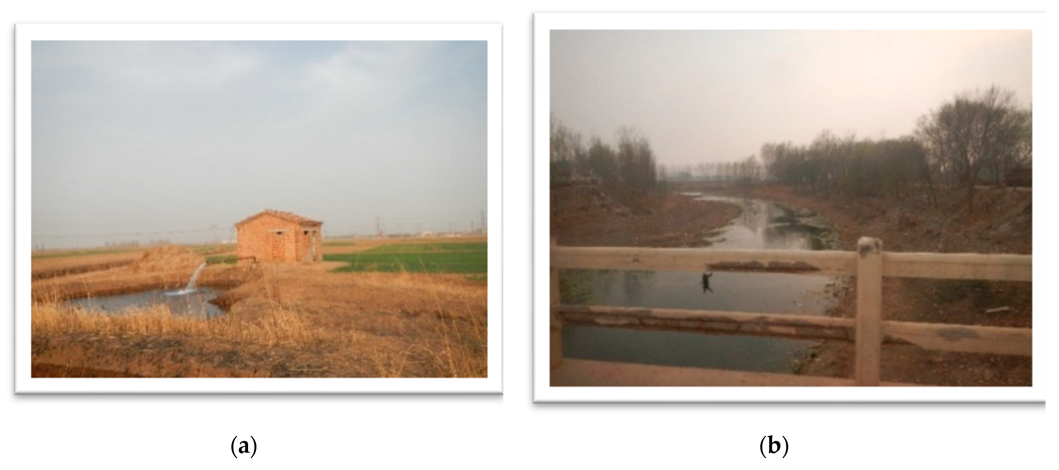
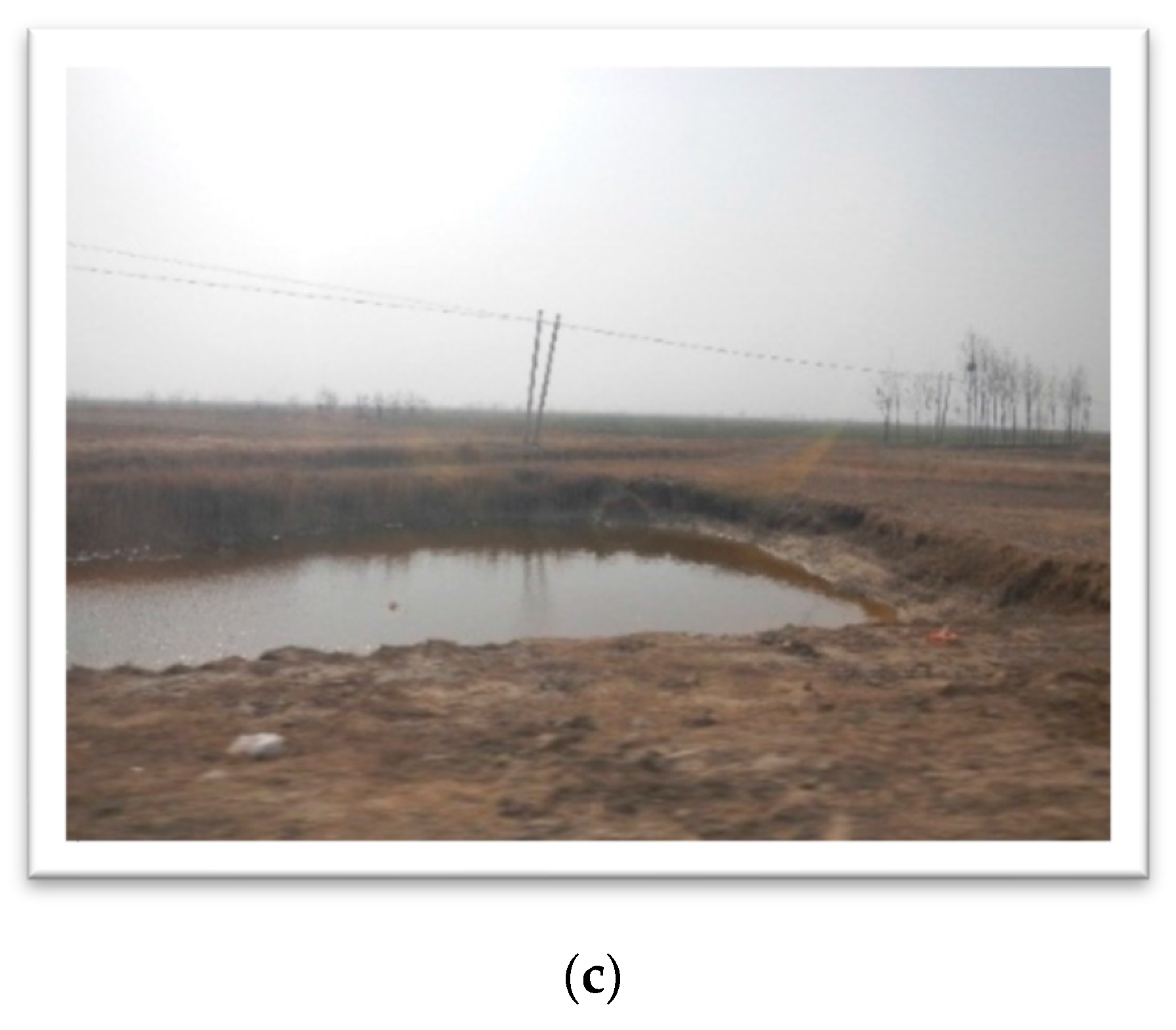
On the basis of the responses we collated from farmers, it is clear that across the study area, irrigation water mainly comes from groundwater, surface water from rivers, and surface water from reservoirs (Figure 3). Therefore, and as discussed above, we defined five irrigation water source types that applied to the land plots surveyed in this study: “ground and surface water”, “just groundwater”, “just rivers”, “just reservoirs”, and “no irrigation”.
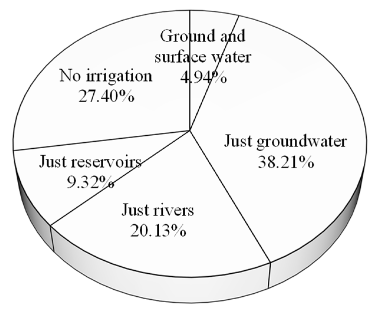
(1) “Ground and surface water” in this study refers to the use of both groundwater and surface water for the irrigation of winter wheat on a given land plot. In this case, surface water is derived from either rivers or reservoirs. Only 4.94% of the land plots surveyed could be irrigated by both ground and surface water (Figure 4).
(2) “Just groundwater” refers to cases in which this is the single water source for the irrigation of a land plot. It is noteworthy that the groundwater from shallow aquifers within the study area was characterized by high salinity and was not suitable for crops; thus, groundwater for agricultural use in this area was only pumped from deep aquifers, and the irrigation depth applied ranged between 295 and 500 m, with an average of 373 m. “Just groundwater” was the water source for 38.21% of the land plots surveyed (Figure 4).
(3) “Just rivers” refers to cases in which this is the single water source for the irrigation of a land plot. However, distinct from a stable groundwater supply, available surface water from rivers can vary a great deal because of changes in natural precipitation and water volume fluctuations that result from flow in the Middle Route of the South-to-North Water Transfer Project (MRP) as well as sewage treatment systems in urban areas of Cangxian County. Of all the land plots surveyed, 20.13% could use irrigation water from just rivers (Figure 4).
(4) “Just reservoirs” refers to cases in which this is the single water source for the irrigation of a land plot. Such installations within the study area had usually been spontaneously excavated by villagers to store rainfall for subsequent use in irrigation. According to Figure 4, the percentage of land plots using irrigation water from just reservoirs accounted for 9.32%.
(5) “No irrigation” refers to the absence of wells, rivers, and reservoirs in use for a given land plot, or a situation in which these features were too distant to be useful for irrigation. On the basis of our survey, a total of 27.40% of land plots could not be irrigated (Figure 4).
The data presented in Figure 5 show that irrigation frequencies within the study area ranged between 0 and 4, and that their patterns were different depending on available water sources. The data show that 90% of land plots irrigated by two water sources or by “just groundwater” had irrigation frequencies greater than 2, and that one-third had frequencies greater than 3. In contrast, 65% of land plots irrigated by “just rivers” or “just reservoirs” had irrigation frequencies greater than 2, and just 20% had irrigation frequencies greater than 3. Average winter wheat irrigation frequencies for land plots watered with “groundwater and surface water”, “just groundwater”, “just reservoirs” or “just rivers” were 2.40, 2.24, 1.90, and 1.80, respectively, revealing a decreasing IWA trend. Unsurprisingly, cases of “no irrigation” had the lowest IWA.
Next, we established four dummy variables for the five irrigation water sources. These variables were included in the multilevel models to determine the role of the irrigation water source and corresponding IWA in winter wheat abandonment (Table 1). We also added a number of additional potentially explanatory variables, including soil quality, farming distance, and plot size (plot level), non-agricultural income per laborer, agricultural labor availability, age, education, dependent ratio, farm equipment, and land fragmentation (household level), and well depth, irrigation price, distance to county center, and land rental rate (village level) (Table 1).
2.3. Multilevel Modeling Specifications
Multilevel modeling is a statistically sound methodology that utilizes regression models and explicitly takes into account variation at different levels. This approach has been used successfully in a number of recent studies that have evaluated the determinants of land use change in China [24,25,26,27]. We applied multilevel models in this study to determine the role of IWA in the cropping-system decisions made by farmers.
As discussed, three major cropping systems were seen within our study area, a spring maize single-cropping system (i.e., single-cropping system), a winter wheat/summer maize/spring maize triple-cropping system that takes place over 2 years (i.e., triple-cropping over two years), and a winter wheat/summer maize double-cropping system (i.e., double-cropping system). We used 1, 2, and 3 to refer to these three systems (Table 1); thus, a cropping-system decision was a multinomial variable, and multilevel multinomial models were optimal. The full three-level multinomial models were structured as follows:
where Prob(Rijk = m) denotes the probability of occurrence of a cropping system, m; thus, m = 1 or m = 2 with m = 3 as the reference group. Similarly, the subscripts i, j, and k are indices of land plots, households, and villages, respectively, while Irrigation is a vector containing the four irrigation-water-source dummy variables and α is a vector of their coefficients. X, Y, and Z represent other explanatory variables at land plot, household and village levels, respectively, while β, δ, and ϑ are their corresponding regression coefficients; γ000 is the fixed intercept to be estimated, and r0 and u00 are random intercepts at the household and village levels, respectively. Both of these intercepts have an assumed random distribution and mean values of 0.
All of the analyses reported in this paper were performed using the multilevel statistical software package HLM version 7 [28]. We estimated intraclass correlation coefficients to denote the proportions of variance explained by a given group level, as follows:
where ρh and ρv are the intraclass coefficients for household and village levels, respectively, while VAR(γ0) and VAR(μ00) denote the variances of random intercepts at the same levels, and π2/3 represents the residual variance at the plot level [25].
3. Results
3.1. Background Information and the Determinants Perceived by Farmers for Winter Wheat Abandonment
The total cultivated land area investigated in this study was 220.13 ha; within this, the single-cropping system used 79.21 ha (35.98%), 39.04 ha (17.74%) adopted a 2-year triple-cropping system, and 95.49 ha (43.38%) adopted a double-cropping system (Table 2). Other crops were grown on just 6.39 ha (2.90%) of the total area, mainly including soybean, peanut, and sweet potato. Out of the total individuals surveyed in this study, 924 were male and 858 were female, while in terms of laborers, the numbers of agricultural and off-farm workers were much higher overall than the numbers of part-time farming laborers. The households surveyed usually owned several small, scattered plots of land; the average land area owned per household was 4.39 plots and 0.65 ha. In terms of irrigation water sources at the village level, the average number of irrigation wells, rivers, and reservoirs were 3.91, 0.89, and 0.31, respectively. Groundwater was the only irrigation water type present in all the villages.
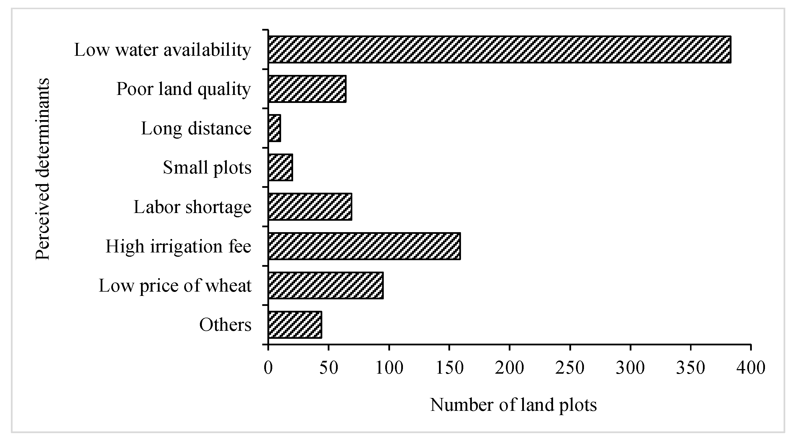
The survey results show that the most important factor perceived by farmers to determine winter wheat abandonment is low water availability (Figure 6). At the same time, high irrigation costs, low price of wheat, poor land quality, and labor shortages also play important roles in the decisions made by farmers to abandon their winter wheat. Other reported causes also include poor water quality for irrigation, and “peer effects” (i.e., one farmer abandons winter wheat because others are doing the same). It is also noteworthy that few farmers reported small plot sizes and distances from their households as significant determining factors leading to abandonment; these results imply that both plot size and distance to residence are not significant to cropping decisions. The perspectives of farmers may, however, be exaggerated or ignored by our survey for a number of reasons, therefore requiring clarification by our modeling approach. Indeed, the perceived determinants of farmers revealed by our survey provide valuable reference data for the selection of potential additional variables (Table 1).
3.2. Econometric Results from Multilevel Models
As discussed, a series of multilevel multinomial models were constructed in this study to pinpoint the roles of the irrigation water source and other determinants in the cropping-system decisions made by farmers. Four model groups were established, each containing a different set of explanatory variables; each group contained two models, as winter wheat abandonment is seen in two cropping systems (i.e., single-cropping and 2-year triple-cropping), and the double-cropping system was used as the control group (Table 3). Although a test for multicollinearity was performed among the explanatory variables, the results show that this is not a significant issue with our models.
Utilizing the “no irrigation” case as the control group for this study, the results show that the “ground and surface water”, “just groundwater”, “just rivers”, and “just reservoirs” irrigation cases all had significant negative roles in Models 1A–1B. In all cases, the coefficient signs were consistent and the changes in magnitudes were minor when more explanatory variables were added in Models 2A–4A and in Models 2B–4B. Thus, a double-cropping system is less likely on land plots that cannot be irrigated, and these areas are more likely to suffer winter wheat abandonment. In terms of absolute values, the coefficients of the “ground and surface water” case were always the largest, followed successively by those of “just groundwater”, with those for “just rivers” always being the smallest; this result is consistent with an increasing trend towards the adoption of single-cropping or 2 year triple-cropping systems as well as a decreasing trend in winter wheat abandonment. Thus, taking into account changing trends in irrigation frequencies for different water sources (Section 2.2), these results can also be interpreted as indicative of the fact that land plots using irrigation water sources with larger irrigation frequencies (i.e., higher IWA) are less prone to winter wheat abandonment. More specifically, absolute values recovered for “ground and surface water”, “just groundwater”, “just rivers”, and “just reservoirs” were much higher in Models 1A–4A than they were in Models 1B–4B. In other words, compared with land plots that could not be irrigated (i.e., zero IWA), those with higher IWA values were more likely to adopt a 2-year triple-cropping system compared to single-cropping.
Regarding other determinants, the coefficients of soil quality and plot size at the level of plots were both significant in Models 2A–4A and Models 2B–4B; however, the coefficient signs were positive and negative, respectively, implying that winter wheat abandonment is less likely on good-quality, large-area land plots. At the household level, the coefficients of agricultural labor availability and farming equipment were both significant and negative in Models 3A–4A and Models 3B–4B; these results imply that winter wheat abandonment is more likely in households with fewer agricultural laborers that do not possess tractors. In contrast, the coefficients of non-agricultural income per laborer, education, and land fragmentation were all significant and positive in Models 2A–4A but were all insignificant in Models 2B–4B; these results imply that households with a larger non-agricultural income per laborer, a well-educated agricultural leader, and more fragmented plots of land are more likely to adopt a single-cropping system as opposed to double-cropping or 2 year triple-cropping systems. The coefficients for age and age squared were also both significant but had opposite effects in Models 3A–4A and Models 3B–4B, exhibiting positive coefficients for the quadratic form but negative coefficients for the root form. These results imply that middle-aged agricultural laborers have a lower probability of abandoning winter wheat plots, while their counterparts who are either too young or too old have larger probabilities. Only the irrigation price coefficient was significant at the village level in both Models 4A and 4B; the coefficient signs were positive in both cases, implying high ratios of winter wheat abandonment in villages where irrigation prices are also elevated. The coefficients of farming distance and land rental rate were only significant in Model 4B, suggesting that land plots at short distances from farms and villages with high land rental rates were more likely to adopt mono-cropping rotations in 1 year (i.e., either a single-cropping or double-cropping system) rather than 2-year triple-cropping. Dependent ratios at the household level, well depth, and distance to the county center at the village level were all insignificant factors in the cropping decisions made by farmers.
Considering random effects, the results of Models 1A and 1B both show significant variance at the village level (Table 3), implying significant differences in cropping systems between villages. However, variances at the household level were both not significant; indeed, the lack of significance in Model 1A reveals no significant difference in the adoption ratios of single-cropping systems versus double-cropping systems at the household level. The intraclass coefficients of variance at both the household and village levels for Model 1A, 7.5% and 35.2%, can be explained at these levels, respectively, while the remaining 57.3% should be attributed to the level of plots. Similarly, the intraclass coefficients of variance in Model 1B, 39.9% and 23.9%, can also be explained at the household and village levels, respectively, while 36.2% can be explained at the plot level.
4. Discussion
4.1. IWA and Irrigation Water Source
The focus of this study was on the role of IWA in winter wheat abandonment on the NCP. In this context, the irrigation water source was used as a proxy for the irrigation frequency, an equivalent indicator for IWA, as the source of irrigation water is the only significant factor influencing the irrigation frequency of winter wheat in the NCP (Section 2.2).
We then established a series of multilevel Poisson models to identify the factors influencing the irrigation frequency. Four dummy irrigation water source variables were included in these models, alongside other potential variables (Table 1). A summary of all our results is presented in Appendix A; these data show that the irrigation-water-source dummy variables all played significant roles. The signs of the coefficients of these variables were all positive but diverged from one another when the “no irrigation” case was used as the control group. In contrast, other variables did not exhibit a significant influence on the irrigation frequency; thus, the irrigation water source is the only factor that significantly contributes to the irrigation frequency. This variable can therefore be used as a proxy for both the irrigation frequency and IWA.
4.2. Policy Implications
It is no longer sustainable to irrigate winter wheat using groundwater on the NCP, as this has led to severe overexploitation [29,30]. As alternatives, surface water from rivers and reservoirs has been proposed, and the expansion of areas irrigated by surface water should be a tradeoff between groundwater conservation and food security on the NCP [8]. However, the surface water supply is erratic, and the IWA of surface waters from rivers and reservoirs is much lower than that of groundwater. Thus, the integrative management of ground and surface water is necessary, and close attention should be paid to surface water collection and utilization, including water channel and reservoir construction, rainwater harvesting, and biotechnological advances [31].
Except natural rainfall, water transferred from the MRP and recycled water emitted from the sewage treatment systems in urban areas are two essential surface water sources on the NCP. The main aims of the MRP are to supply water for industrial, domestic, ecological, and agricultural use in the four cities and provinces of Beijing, Tianjin, Hebei, and Henan [32]. Inevitably, water will be allocated for agricultural use in areas where there are channels for the MRP. A range of policies have therefore been suggested, including the development of a water-rights system, the establishment of an effective water property system, a water trade market, and the formulation of benefit allocation mechanisms to properly reallocate transferred water [33,34]. In contrast, recycled water tends to be poorer in quality; this is also characteristic of rainfall harvested in reservoirs, which is a big threat to the safety of wheat. Much greater attention should therefore be paid by local governments to improve the quality of recycled water and rainfall harvested in reservoirs. The use of biological purification technologies are highly recommended [35].
4.3. The Main Shortcomings of This Study
Our models had a number of inherent shortcomings, including the fact that we only considered the fixed effects of determinants on the decisions made by farmers using multilevel multinomial models. We also abandoned random slope effects both at the household and village levels because estimated variances were not significant. In other words, because our data structure was characterized by observations of 1535 land plots nested within 350 households and 35 villages, both the number of land plots per household and the number of households per village, respectively, were small, which may have hampered the random slope estimation. This result is consistent with previous studies that have also identified insignificant random slopes or models that do not converge [25,36]. Thus, as no argument has so far been proposed to explain why the relationship between explanatory and dependent variables are different when random slopes are included, we employed multilevel models that lack these features.
Additionally, we focused on the influence of IWA, that is, the most frequently mentioned reason given by farmers for winter wheat abandonment, and did not fully launch discussions on other influencing factors, including the soil quality and plot size at the plot level, as well as demographic characteristics, farm equipment, land fragmentation at the household level and irrigation prices at the village level. Further analysis is needed for in-depth explorations of these factors and their influencing mechanisms on winter wheat abandonment.
Finally, we selected Cangxian County as our case study area, and the incorporated results were concluded from household surveys. We note that future results may be more refined if they are based on larger numbers of questionnaires from more case study areas across the NCP.
5. Conclusions
We used a series of multi-level multinomial models in this study to reveal the role of IWA in the cropping system decisions made by farmers that lead to the eventual abandonment of winter wheat. To do this, we used irrigation water source as a proxy for irrigation frequency, an equivalent indicator for IWA. The results of this study reveal that irrigation water source is a crucial factor in explaining the cropping system decisions made by farmers. A total of five irrigation water source types were used to describe land plots within the study area. Thus, taking the ‘no irrigation’ case as a control group, results show that the coefficients of four dummy variables for irrigation water source were all significant and negative. The absolute values for coefficients for ‘ground and surface water’ were the largest in this study, while those for ‘just groundwater’ and ‘just rivers’ were smallest. Further, taking into account corresponding relationships between irrigation water sources and IWA, our results show that land plots with higher IWA irrigation water sources, such as ‘ground and surface water’ and ‘just groundwater’, are more likely to adopt double-cropping systems, while those with lower IWA irrigation water sources, including ‘just reservoirs’ and ‘just rivers’, are more likely to suffer winter wheat abandonment. Winter wheat is seldom planted on land plots that cannot be irrigated (i.e., zero IWA), while other determinants, including soil quality, plot size at the plot level, demographic characteristics, farming equipment, land fragmentation at the household level, and irrigation prices at the village level, all significantly influence the decisions made by farmers whether, or not, to abandon winter wheat.
The results presented in this paper are useful as a case study because they reflect a broader picture of the role of IWA in the decisions made by farmers on cropping systems and winter wheat abandonment on the NCP. Our results also provide support for the development and implementation of sustainable water management policies, with emphasis on the alleviation of water stress while maintaining food supply in areas of China where water resource is scare.
Acknowledgments
This research was supported by the National Key Basic Research and Development Program (2015CB452706) and National Natural Science Foundation of China (41701092). We also thank Wang Renjing and Li Shengfa from IGSNRR for their participation in household surveys, as well as Günther Fischer from the International Institute for Applied Systems Analysis for his valuable comments during the research.
Author Contributions
Xue Wang and Xiubin Li developed the original idea for the study. Xue Wang was responsible for data collecting, data analysis, and writing of the manuscript. Xiubin Li reviewed the manuscript.
Conflicts of Interest
The authors declare no conflict of interest.
Appendix A

Table A1.
Estimation results of multilevel Poisson models for winter wheat irrigation frequencies.
| Variables | Model 1 | Model 2 | Model 3 | Model 4 | Model 5 |
|---|---|---|---|---|---|
| Intercept | 0.730 ** | 0.728 ** | 0.728 ** | 0.727 ** | 1.156 ** |
| Level 1 (Plot Level) | |||||
| Irrigation water source | |||||
| Ground and surface water | 1.163 ** | 1.212 ** | 1.272 ** | 1.190 ** | |
| Just groundwater | 1.132 ** | 1.168 ** | 1.214 ** | 1.118 ** | |
| Just rivers | 0.817 ** | 0.844 ** | 0.888 ** | 0.774 ** | |
| Just reservoirs | 0.985 ** | 1.027 ** | 1.062 ** | 0.943 ** | |
| (No irrigation) | |||||
| Soil quality | 0.003 | 0.002 | 0.001 | ||
| Farming distance | 0.000 | 0.000 | 0.000 | ||
| Plot size | 0.223 | 0.223 | 0.195 | ||
| Level 2 (Household Level) | |||||
| Non-agricultural income per laborer | 0.003 | 0.008 | |||
| Agricultural labor availability | −0.011 | −0.009 | |||
| Age | −0.014 | −0.010 | |||
| Age squared | 0.000 | 0.000 | |||
| Education | 0.010 | 0.012 | |||
| Dependent ratio | −0.100 | −0.104 | |||
| Farming equipment | −0.051 | −0.059 | |||
| Land fragmentation | 0.015 | 0.014 | |||
| Level 3 (Village Level) | |||||
| Well depth | 0.000 | ||||
| Irrigation price | −0.084 | ||||
| Distance to county center | −0.033 | ||||
| Land rental rate | 0.271 | ||||
| Random effects | |||||
| Level 2 (Household Level) | |||||
| VAR (γ0) | 0.002 | 0.002 | 0.002 | 0.002 | 0.002 |
| ρh | 0.000 | 0.000 | 0.000 | 0.000 | 0.000 |
| Level 3 (Village Level) | |||||
| VAR(μ00) | 0.036 ** | 0.037 ** | 0.037 ** | 0.036 ** | 0.007 ** |
| ρv | 0.002 | 0.002 | 0.002 | 0.002 | 0.000 |
Note: The dependent variable in this study was winter wheat irrigation frequency, which ranged between 0 and 4. A multilevel Poisson model was therefore optimal in identifying determinants and was constructed following Raudenbush [28]. The potential explanatory variables are listed in Table 1. Not all households planted winter wheat in all land plots they possessed during the 2013 and 2014 growing season. Thus, just a fraction of total land plots and the households were included in this model. The symbols ** denote significance at 5% levels.
References
- Haney, N.; Cohen, S. Predicting 21st century global agricultural land use with a spatially and temporally explicit regression-based model. Appl. Geogr. 2015, 62, 366–376. [Google Scholar] [CrossRef]
- Van Vliet, J.; de Groot, H.L.F.; Rietveld, P.; Verburg, P.H. Manifestations and underlying drivers of agricultural land use change in Europe. Landsc. Urban Plan. 2015, 133, 24–36. [Google Scholar] [CrossRef]
- Jeong, S.J.; Ho, C.H.; Piao, S.; Kim, J.; Ciais, P.; Lee, Y.B.; Jhun, J.G.; Park, S.K. Effects of double cropping on summer climate of the North China Plain and neighbouring regions. Nat. Clim. Chang. 2014, 4, 615–619. [Google Scholar] [CrossRef]
- Liu, G.; Wang, H.; Cheng, Y.; Zheng, B.; Lu, Z. The impact of rural out-migration on arable land use intensity: Evidence from mountain areas in Guangdong, China. Land Use Policy 2016, 59, 569–579. [Google Scholar] [CrossRef]
- Sakane, N.; van Wijk, M.T.; Langensiepen, M.; Becker, M. A quantitative model for understanding and exploring land use decisions by smallholder agrowetland households in rural areas of East Africa. Agric. Ecosyst. Environ. 2014, 197, 159–173. [Google Scholar] [CrossRef]
- Chen, J.Y.; Tang, C.Y.; Shen, Y.J.; Sakura, Y.; Kondoh, A.; Shimada, J. Use of water balance calculation and tritium to examine the dropdown of groundwater table in the piedmont of the North China Plain (NCP). Environ. Geol. 2003, 44, 564–571. [Google Scholar] [CrossRef]
- Meng, Q.; Sun, Q.; Chen, X.; Cui, Z.; Yue, S.; Zhang, F.; Römheld, V. Alternative cropping systems for sustainable water and nitrogen use in the North China Plain. Agric. Ecosyst. Environ. 2012, 146, 93–102. [Google Scholar] [CrossRef]
- Wang, X.; Li, X.; Fischer, G.; Sun, L.; Tan, M.; Xin, L.; Liang, Z. Impact of the changing area sown to winter wheat on crop water footprint in the North China Plain. Ecol. Indic. 2015, 57, 100–109. [Google Scholar] [CrossRef]
- Song, W. Decoupling cultivated land loss by construction occupation from economic growth in Beijing. Habitat Int. 2014, 43, 198–205. [Google Scholar] [CrossRef]
- Tan, M.; Li, X.; Xie, H.; Lu, C. Urban land expansion and arable land loss in China—A case study of Beijing–Tianjin–Hebei region. Land Use Policy 2005, 22, 187–196. [Google Scholar] [CrossRef]
- Feng, Z.M.; Liu, D.W.; Zhang, Y.H. Water requirements and irrigation scheduling of spring maize using GIS and CropWat model in Beijing-Tianjin-Hebei region. Chin. Geogr. Sci. 2007, 17, 56–63. [Google Scholar] [CrossRef]
- Wang, X.; Li, X.; Xin, L. Impact of the shrinking winter wheat sown area on agricultural water consumption in the Hebei Plain. J. Geogr. Sci. 2014, 24, 313–330. [Google Scholar] [CrossRef]
- Gleeson, T.; Wada, Y.; Bierkens, M.F.P.; van Beek, L.P.H. Water balance of global aquifers revealed by groundwater footprint. Nature 2012, 488, 197–200. [Google Scholar] [CrossRef] [PubMed]
- Liu, J.; Wiberg, D.; Zehnder, A.J.B.; Yang, H. Modeling the role of irrigation in winter wheat yield, crop water productivity, and production in China. Irrig. Sci. 2007, 26, 21–33. [Google Scholar] [CrossRef]
- Li, J.; Inanaga, S.; Li, Z.; Eneji, A.E. Optimizing irrigation scheduling for winter wheat in the North China Plain. Agric. Water Manag. 2005, 76, 8–23. [Google Scholar] [CrossRef]
- Sun, H.; Shen, Y.; Yu, Q.; Flerchinger, G.N.; Zhang, Y.; Liu, C.; Zhang, X. Effect of precipitation change on water balance and WUE of the winter wheat–summer maize rotation in the North China Plain. Agric. Water Manag. 2010, 97, 1139–1145. [Google Scholar] [CrossRef]
- Sun, Q.; Kröbel, R.; Müller, T.; Römheld, V.; Cui, Z.; Zhang, F.; Chen, X. Optimization of yield and water-use of different cropping systems for sustainable groundwater use in North China Plain. Agric. Water Manag. 2011, 98, 808–814. [Google Scholar] [CrossRef]
- Grogan, D.S.; Zhang, F.; Prusevich, A.; Lammers, R.B.; Wisser, D.; Glidden, S.; Li, C.; Frolking, S. Quantifying the link between crop production and mined groundwater irrigation in China. Sci. Total Environ. 2015, 511, 161–175. [Google Scholar] [CrossRef] [PubMed]
- Yang, X.; Chen, Y.; Pacenka, S.; Gao, W.; Ma, L.; Wang, G.; Yan, P.; Sui, P.; Steenhuis, T.S. Effect of diversified crop rotations on groundwater levels and crop water productivity in the North China Plain. J. Hydrol. 2015, 522, 428–438. [Google Scholar] [CrossRef]
- Yang, Y.; Watanabe, M.; Zhang, X.; Zhang, J.; Wang, Q.; Hayashi, S. Optimizing irrigation management for wheat to reduce groundwater depletion in the piedmont region of the Taihang Mountains in the North China Plain. Agric. Water Manag. 2006, 82, 25–44. [Google Scholar] [CrossRef]
- Yang, Y.; Wang, J.; Chen, H. Assessment of water supply reliability of different irrigation water sources. China Popul. Resour. Environ. 2012, 22, 97–100. (In Chinese) [Google Scholar]
- Wang, J.; Yang, Y.; Huang, J.; Chen, K. Information provision, policy support, and farmers’ adaptive responses against drought: An empirical study in the North China Plain. Ecol. Model. 2015, 318, 275–282. [Google Scholar] [CrossRef]
- Shen, Y.; Zhang, Y.; Scanlon, B.R.; Lei, H.; Yang, D.; Yang, F. Energy/water budgets and productivity of the typical croplands irrigated with groundwater and surface water in the North China Plain. Agric. For. Meteorol. 2013, 181, 133–142. [Google Scholar] [CrossRef]
- Su, S.; Zhou, X.; Wan, C.; Li, Y.; Kong, W. Land use changes to cash crop plantations: Crop types, multilevel determinants and policy implications. Land Use Policy 2016, 50, 379–389. [Google Scholar] [CrossRef]
- Zhang, Y.; Li, X.; Song, W. Determinants of cropland abandonment at the parcel, household and village levels in mountain areas of China: A multi-level analysis. Land Use Policy 2014, 41, 186–192. [Google Scholar] [CrossRef]
- Jiang, L.; Deng, X.; Seto, K.C. Multi-level modeling of urban expansion and cultivated land conversion for urban hotspot counties in China. Landsc. Urban Plan. 2012, 108, 131–139. [Google Scholar] [CrossRef]
- Snijders, T.A.B.; Boksker, R.J. (Eds.) Multilevel Analysis: An Introduction to Basic and Advanced Multilevel Modelling; Sage: New York, NY, USA, 1999. [Google Scholar]
- Raudenbush, S.W. (Ed.) Hierarchical Linear Models: Applications and Data Analysis Methods; Sage Publications: Thousand Oaks, CA, USA, 2002. [Google Scholar]
- Hu, Y.; Moiwo, J.P.; Yang, Y.; Han, S.; Yang, Y. Agricultural water-saving and sustainable groundwater management in Shijiazhuang Irrigation District, North China Plain. J. Hydrol. 2010, 393, 219–232. [Google Scholar] [CrossRef]
- Aeschbach-Hertig, W.; Gleeson, T. Regional strategies for the accelerating global problem of groundwater depletion. Nat. Geosci. 2012, 5, 853–861. [Google Scholar] [CrossRef]
- Liu, J.; Zehnder, A.J.B.; Yang, H. Global consumptive water use for crop production: The importance of green water and virtual water. Water Resour. Res. 2009, 45. [Google Scholar] [CrossRef]
- Chinese Radio Network. The Water Transfer Begins Today from the First Phase of the Middle Route of the Water Transfer Project. 2014. Available online: http://china.cnr.cn/ygxw/201412/t20141212_517092128.shtml (accessed on 12 December 2014). (In Chinese).
- Calow, R.C.; Howarth, S.E.; Wang, J. Irrigation Development and Water Rights Reform in China. Int. J. Water Resour. Dev. 2009, 25, 227–248. [Google Scholar] [CrossRef]
- Zuo, Q.; Hu, D.; Dou, M.; Zhang, X. Framework and core system of the most stringent water resource management system based on the concept of human-water harmony. Resour. Sci. 2014, 36, 906–912. (In Chinese) [Google Scholar]
- Li, J.; Jiang, C.; Lei, T.; Li, Y. Experimental study and simulation of water quality purification of urban surface runoff using non-vegetated bioswales. Ecol. Eng. 2016, 95, 706–713. [Google Scholar] [CrossRef]
- Overmars, K.P.; Verburg, P.H. Multilevel modelling of land use from field to village level in the Philippines. Agric. Syst. 2006, 89, 435–456. [Google Scholar] [CrossRef]
Figure 1.
Location of the case study area, including the major grain producing towns and villages sampled in this study.
Figure 1.
Location of the case study area, including the major grain producing towns and villages sampled in this study.
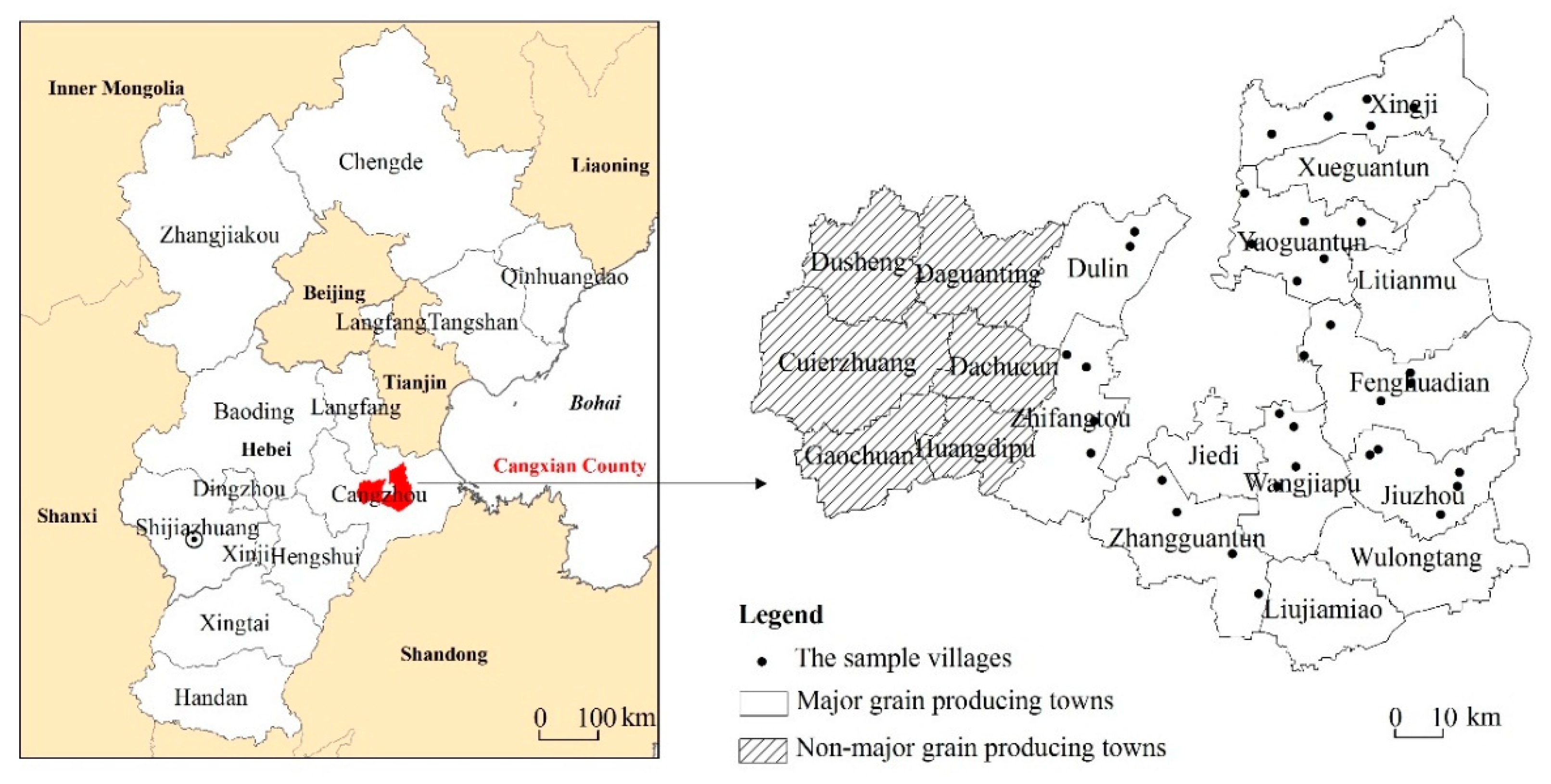
Figure 2.
The monthly average temperature and precipitation of the case study area during 2000–2010 (Source: Cangzhou meteorological station).
Figure 2.
The monthly average temperature and precipitation of the case study area during 2000–2010 (Source: Cangzhou meteorological station).
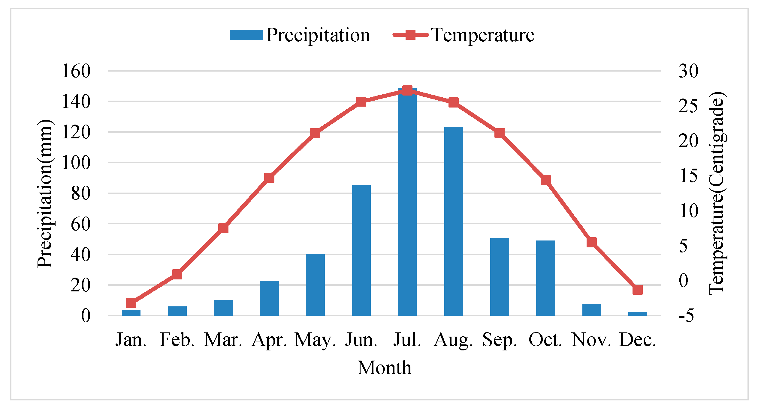
Figure 3.
Examples of irrigation water sources used within the case study area (photos taken in March 2015). (a) Groundwater from a motor-pumped well inside a small house. (b) River containing residual water. (c) Reservoir preserving rainfall water.
Figure 3.
Examples of irrigation water sources used within the case study area (photos taken in March 2015). (a) Groundwater from a motor-pumped well inside a small house. (b) River containing residual water. (c) Reservoir preserving rainfall water.


Figure 4.
Percentage of land plots using different irrigation water sources (Source: authors’ survey).
Figure 4.
Percentage of land plots using different irrigation water sources (Source: authors’ survey).

Figure 5.
Percentage of land plots implementing different frequencies of irrigation for winter wheat. These data were sorted on the basis of irrigation water sources and were derived from surveys (Source: authors’ survey).
Figure 5.
Percentage of land plots implementing different frequencies of irrigation for winter wheat. These data were sorted on the basis of irrigation water sources and were derived from surveys (Source: authors’ survey).
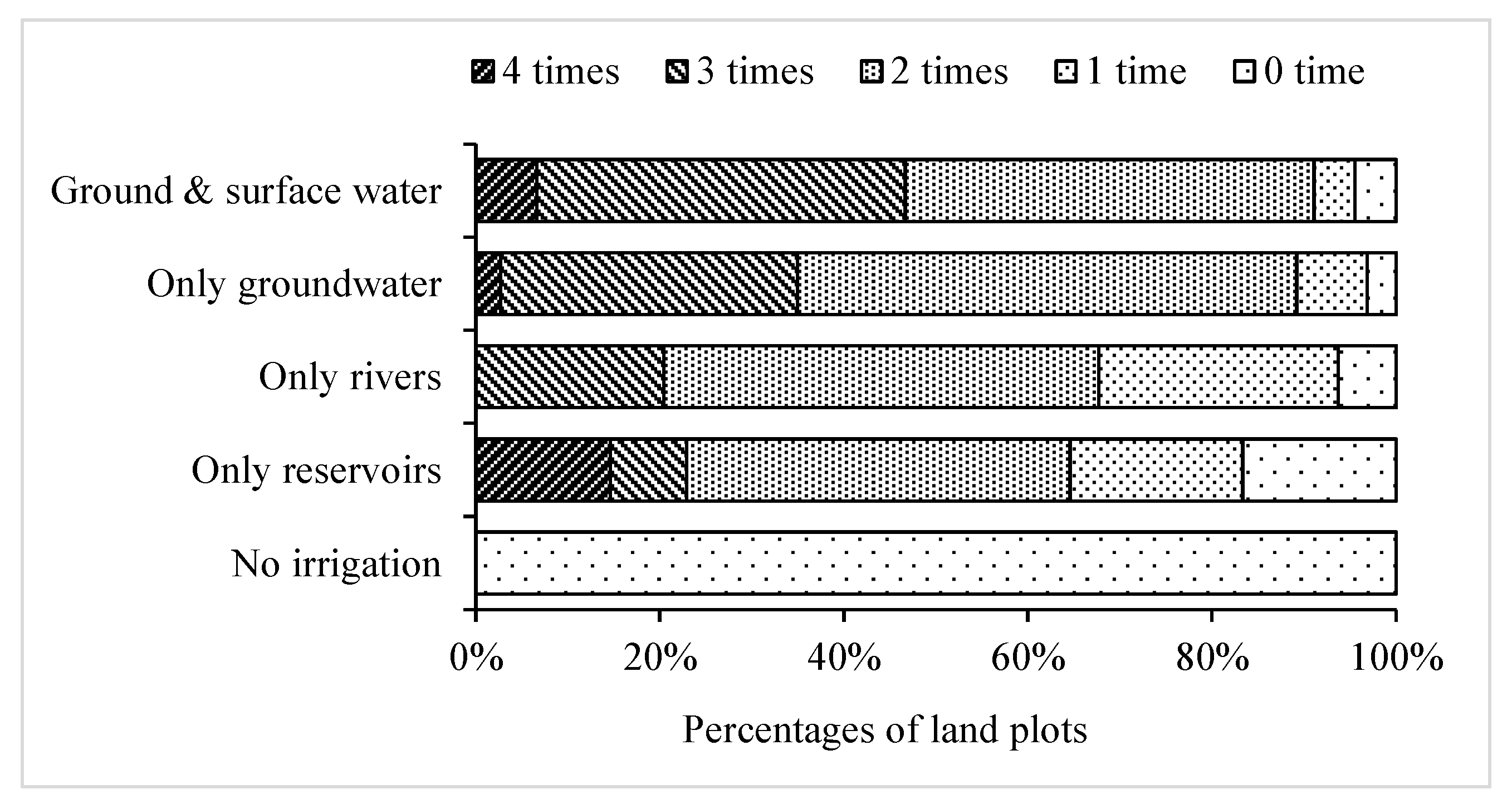
Figure 6.
Summary of determinants perceived by farmers for winter wheat abandonment on land plots adopting either single-cropping or 2-year triple-cropping systems. (Source: authors’ survey).
Figure 6.
Summary of determinants perceived by farmers for winter wheat abandonment on land plots adopting either single-cropping or 2-year triple-cropping systems. (Source: authors’ survey).

Table 1.
The variables included in multilevel models.
| Variable | Definition | Mean | S.D. | Min | Max |
|---|---|---|---|---|---|
| Dependent Variable (Plot Level, n = 1416) | |||||
| Cropping system | 1: single-cropping system; 2: triple-cropping over 2 years; 3: double-cropping system | 2.00 | 0.91 | 1.00 | 3.00 |
| Explanatory Variables | |||||
| Level 1 (plot level, n = 1416) | |||||
| Irrigation water source | |||||
| Ground and surface water | Dummy variable (yes = 1; no = 0) | 0.05 | 0.22 | 0.00 | 1.00 |
| Just groundwater | Dummy variable (yes = 1; no = 0) | 0.38 | 0.49 | 0.00 | 1.00 |
| Just rivers | Dummy variable (yes = 1; no = 0) | 0.20 | 0.40 | 0.00 | 1.00 |
| Just reservoirs | Dummy variable (yes = 1; no = 0) | 0.09 | 0.29 | 0.00 | 1.00 |
| No irrigation | Reference group | ||||
| Soil quality | 1: good land; 2: relatively good land; 3: relatively poor land; 4: poor land | 2.05 | 0.96 | 1.00 | 4.00 |
| Farming distance | Distance from the land plot to household residence (km) | 0.92 | 0.65 | 0.05 | 4.00 |
| Plot size | Land plot area (ha) | 0.15 | 0.10 | 0.01 | 0.73 |
| Level 2 (household level, n = 350) | |||||
| Non-agricultural income per laborer | Total non-agricultural income divided by total non-agricultural laborers (103 yuan/capita) | 3.07 | 1.97 | 0.00 | 10.50 |
| Agricultural labor availability | Number of agricultural laborers per unit of farmland area (laborer/ha) | 4.50 | 3.24 | 0.60 | 24.52 |
| Age | Age of agricultural leader (years) | 57.00 | 10.55 | 24.00 | 87.00 |
| Educational level | Education status of the agricultural leader (1: illiterate; 2: primary school; 3: junior middle school; 4: senior middle school; 5: college or above) | 2.29 | 0.79 | 1.00 | 5.00 |
| Dependent ratio | Ratio of people older than 60 or younger than 16 to total laborers | 0.49 | 0.42 | 0.00 | 2.00 |
| Farming equipment | 1: tractors; 0: without tractors | 0.31 | 0.46 | 0.00 | 1.00 |
| Land fragmentation | Total number of plots divided by total farmland area (ha−1) | 7.15 | 2.82 | 2.50 | 20.27 |
| Level 3 (village level, n = 35) | |||||
| Well depth | Average depth of irrigation wells in the village (m) | 372.60 | 56.77 | 295.00 | 500.00 |
| Irrigation price | Electricity price for irrigation (yuan/kilowatt-hour) | 0.77 | 0.39 | 0.00 | 2.00 |
| Distance to county center | The nearest distance from the village to the county center (km) | 14.43 | 5.19 | 5.77 | 25.24 |
| Land rental rate | Ratio of leasing land to all cropland in the village | 0.04 | 0.07 | 0.00 | 0.42 |
Source: authors’ survey.
Table 2.
Background information: the land plots, households, and villages sampled in this study.
| Number | ||
|---|---|---|
| Cropping system | Single-cropping system/ha | 79.21 |
| Triple-cropping in 2 years/ha | 39.04 | |
| Double-cropping system/ha | 95.49 | |
| Others/ha | 6.39 | |
| Individuals | Male per capita | 924 |
| Female per capita | 858 | |
| Laborers | Agricultural laborer per capita | 637 |
| Part-time farming laborer per capita | 138 | |
| Off-farm laborer per capita | 674 | |
| Average number of land plots owned per household | 4.39 | |
| Average area of land owned per household/ha | 0.65 | |
| Average number of irrigation wells per village | 3.91 | |
| Average number of rivers per village | 0.89 | |
| Average number of reservoirs per village | 0.31 | |
Notes: rivers and reservoirs may be co-owned by more than one village. Source: authors’ survey.
Table 3.
Parameter estimation results of multilevel multinomial models.
| Variables | Single-Cropping System Versus Double-Cropping System | Two-Year Triple-Cropping Versus Double-Cropping System | ||||||
|---|---|---|---|---|---|---|---|---|
| Model 1A | Model 2A | Model 3A | Model 4A | Model 1B | Model 2B | Model 3B | Model 4B | |
| Fixed effects | ||||||||
| Intercept | −4.129 | −3.012 *** | −3.278 *** | −4.436 ** | −2.673 *** | −1.636 *** | −1.848 *** | −2.697 |
| Level 1 (Plot Level) | ||||||||
| Irrigation water source | ||||||||
| Ground and surface water | −7.798 *** | −7.138 *** | −7.479 *** | −7.536 *** | −3.163 *** | −2.836 *** | −3.262 *** | −3.282 *** |
| Just groundwater | −5.932 *** | −5.686 *** | −6.031 *** | −6.125 *** | −2.342 *** | −2.161 *** | −2.515 *** | −2.549 *** |
| Just rivers | −4.733 *** | −4.796 *** | −5.047 *** | −5.129 *** | −1.485 ** | −1.554 ** | −1.736 ** | −1.822 *** |
| Just reservoirs | −4.749 *** | −4.821 *** | −5.244 *** | −5.336 *** | −1.505 *** | −1.497 *** | −1.932 *** | −1.978 *** |
| (No irrigation) | ||||||||
| Soil quality | 0.781 *** | 0.814 *** | 0.818 *** | 0.357 *** | 0.377 ** | 0.379 ** | ||
| Farming distance | −0.052 | −0.073 | −0.068 | 0.529 *** | 0.525 *** | 0.528 ** | ||
| Plot size | −3.660 *** | −3.885 *** | −3.900 *** | −1.905 * | −2.115 * | −2.130 * | ||
| Level 2 (Household Level) | ||||||||
| Non-agricultural income per laborer | 0.092 * | 0.085 * | 0.036 | 0.049 | ||||
| Agricultural labor availability | −0.223 *** | −0.225 *** | −0.131 ** | −0.115 * | ||||
| Age | −0.263 *** | −0.285 *** | −0.327 ** | −0.308 ** | ||||
| Age squared | 0.002 *** | 0.003 *** | 0.003 ** | 0.003 ** | ||||
| Education | 0.305 ** | 0.324 ** | 0.126 | 0.081 | ||||
| Dependent ratio | 0.206 | 0.220 | −0.530 | −0.503 | ||||
| Farming equipment | −1.231 *** | −1.298 *** | −1.361 *** | −1.398 *** | ||||
| Land fragmentation | 0.167 *** | 0.175 *** | 0.015 | 0.041 | ||||
| Level 3 (Village Level) | ||||||||
| Well depth | −0.005 | −0.004 | ||||||
| Irrigation price | 2.730 *** | 1.834 ** | ||||||
| Distance to county center | 0.069 | 0.090 | ||||||
| Land rental rate | −3.085 | −10.799 ** | ||||||
| Random effects | ||||||||
| Level 2 (Household Level) | ||||||||
| VAR(γ0) | 0.430 a | 1.504 | 1.138 *** | 1.222 *** | 3.629 a,*** | 3.799 *** | 3.613 *** | 3.616 *** |
| ρh | 0.075 a | 0.183 | 0.149 | 0.186 | 0.399 a | 0.389 | 0.376 | 0.424 |
| Level 3 (Village Level) | ||||||||
| VAR(μ00) | 2.021 a,*** | 3.409 *** | 3.229 *** | 2.056 *** | 2.173 a,*** | 2.680 *** | 2.710 *** | 1.631 *** |
| ρv | 0.352 a | 0.416 | 0.422 | 0.313 | 0.239 a | 0.274 | 0.282 | 0.191 |
Notes: Models 1A and 1B contained only dummy variables for the four irrigation water sources at the plot level, while Models 2A and 2B contained all variables at the plot level. Similarly, Models 3A and 3B contained all variables at both plot and household levels, while Models 4A and 4B contained all variables at all three levels (i.e., plot, household, and village levels). The symbols *, **, and *** denote significance at 1%, 5%, and 10% levels, respectively. a Refers to results of variances and intraclass coefficients in a null model without consideration of any explanatory variables—not real results of Model As, for the purpose of obtaining the explanation ratios of different levels [25].
© 2018 by the authors. Licensee MDPI, Basel, Switzerland. This article is an open access article distributed under the terms and conditions of the Creative Commons Attribution (CC BY) license (http://creativecommons.org/licenses/by/4.0/).
Share and Cite
MDPI and ACS Style
Wang, X.; Li, X. Irrigation Water Availability and Winter Wheat Abandonment in the North China Plain (NCP): Findings from a Case Study in Cangxian County of Hebei Province. Sustainability 2018, 10, 354. https://doi.org/10.3390/su10020354
AMA Style
Wang X, Li X. Irrigation Water Availability and Winter Wheat Abandonment in the North China Plain (NCP): Findings from a Case Study in Cangxian County of Hebei Province. Sustainability. 2018; 10(2):354. https://doi.org/10.3390/su10020354
Chicago/Turabian StyleWang, Xue, and Xiubin Li. 2018. "Irrigation Water Availability and Winter Wheat Abandonment in the North China Plain (NCP): Findings from a Case Study in Cangxian County of Hebei Province" Sustainability 10, no. 2: 354. https://doi.org/10.3390/su10020354
Note that from the first issue of 2016, this journal uses article numbers instead of page numbers. See further details here.