Using Toponyms to Analyze the Endangered Manchu Language in Northeast China
by
 , , , ,
Zhenhua Zhu
 ,
,
Hongyan Zhang
*,
Jianjun Zhao
,
Xiaoyi Guo
,
Zhengxiang Zhang
,
Yanling Ding
and
Tao Xiong
School of Geographical Sciences, Northeast Normal University, Changchun 130024, China
*
Author to whom correspondence should be addressed.
Sustainability 2018, 10(2), 563; https://doi.org/10.3390/su10020563
Submission received: 12 January 2018
/
Revised: 14 February 2018
/
Accepted: 16 February 2018
/
Published: 24 February 2018
(This article belongs to the Special Issue Cultural Heritage Conservation and Sustainability)
Abstract
:UNESCO has classified Manchu in Northeast China as a critically endangered language. Toponyms can act as carriers of languages and can be preserved for a long time. The Manchu language was the national language in the Qing Dynasty, and there are many Manchu place names in Northeast China that serve as “living heritages” that retain traces of ancient local cultures. We studied Manchu and other related ethnic place names in Northeast China by integrating spatial statistical measures using geographic information systems (GIS) to analyze the endangered languages in the region. The objective was to explore not only the distribution of ethnic toponyms within a relevant historical context but also the environmental factors associated with the endangered Manchu languages. This study reveals that the distributions of ethnic groups and languages can be revealed by the Sinification of ethnic toponyms in Northeast China. The evolution of spatial patterns of toponyms shows the interactive process between Manchus and Han Chinese. The Manchu language is endangered by the influences of Han Chinese migrants on the original culture, as reflected by crops and the distances to the nearest roads, which are indicators of farming culture and accessibility.
1. Introduction
The Manchu language was once the national language of China but is now severely endangered. During the Qing Dynasty (AD 1644–1912), Manchu was the official language and was therefore used by the government [1]. According to UNESCO, there were at least one million native speakers by the end of the Qing Dynasty, but now, among nearly ten million ethnic Manchus, there are only ten native Manchu speakers in Northeast China [2]. In addition to representing a reduction in linguistic diversity, an endangered language represents the disappearance of a cultural heritage [3]. There have been few studies of the endangered Manchu language [4,5,6]. Although there are only a very small number of native speakers in Northeast China, which was the birthplace of Manchu, there are a large number of ethnolinguistic place names, particularly in the Manchu language [7]. For example, the name Jilin, which is the name of both the Jilin Province and its second-largest city, means “beyond the river” in the Manchu language because the city stands by the Songhua River [8].
In addition to location information, toponyms (place names) provide a range of attributive information [9]. With the development of critical place-name studies [10], it has become clear that place names can provide information on not only natural factors, such as ethnopedology [11] and vegetation coverage [12] but also anthropological factors, such as racism [13] and ethnoculture [14]. A place name can also serve as a proxy for historical situations and provide insight into the heritage of a specific place during an earlier time [15], such as local land use [16], landscape [17] and streetscape [18]. Furthermore, toponyms act as “living heritages” that store data about local cultures and languages [19]. Accordingly, although few native Manchu speakers presently exist in Northeast China, Manchu toponyms act as indicators of Manchu culture and language throughout history. Today, studies of Manchu toponyms focus on phonetic or literal translation [20] and naming rules based on certain regions [21,22]. There is a lack of analysis of Manchu toponyms and language in spatial terms [23,24].
The spatial distribution of ethnic toponyms can be visualized and analyzed using geographic information systems (GIS) [25,26]. Local customs and differences among ethnic groups can be identified by analyzing the spatial distribution of ethnic toponyms as influenced by environmental factors [27]. The historical distribution of ethnic groups can be analyzed using a spatio-temporal analysis function based on modern place names [28], and the relationships between natives and the environment can be explored [29]. Furthermore, there is a relationship between linguistic diversity and biological diversity [30,31]. The local communities used their indigenous languages to describe the natural world [32], which can be reflected in toponyms [33,34]. The toponyms of the endangered Manchu language are likely to show relationships with environmental factors [35].
Ecological perspectives and spatial analysis can be applied to determine how a language has become endangered using information derived from place names [36]. Here, we study place names in Northeast China that originate from both Manchu and other related ethnicities using GIS to identify changes over time in the distribution of Manchu in Northeast China. The objective of this paper is not only to analyze the spatial patterns of ethnic toponyms and the evolution of Manchu in a relevant historical context but also to identify differences in environmental factors among ethnic toponyms. The acculturation and assimilation of Manchu during the historical process are indicated by the evolution of the environmental factors associated with place names, and this framework is used to explain how the Manchu language became endangered.
2. Materials and Methods
2.1. Study Area
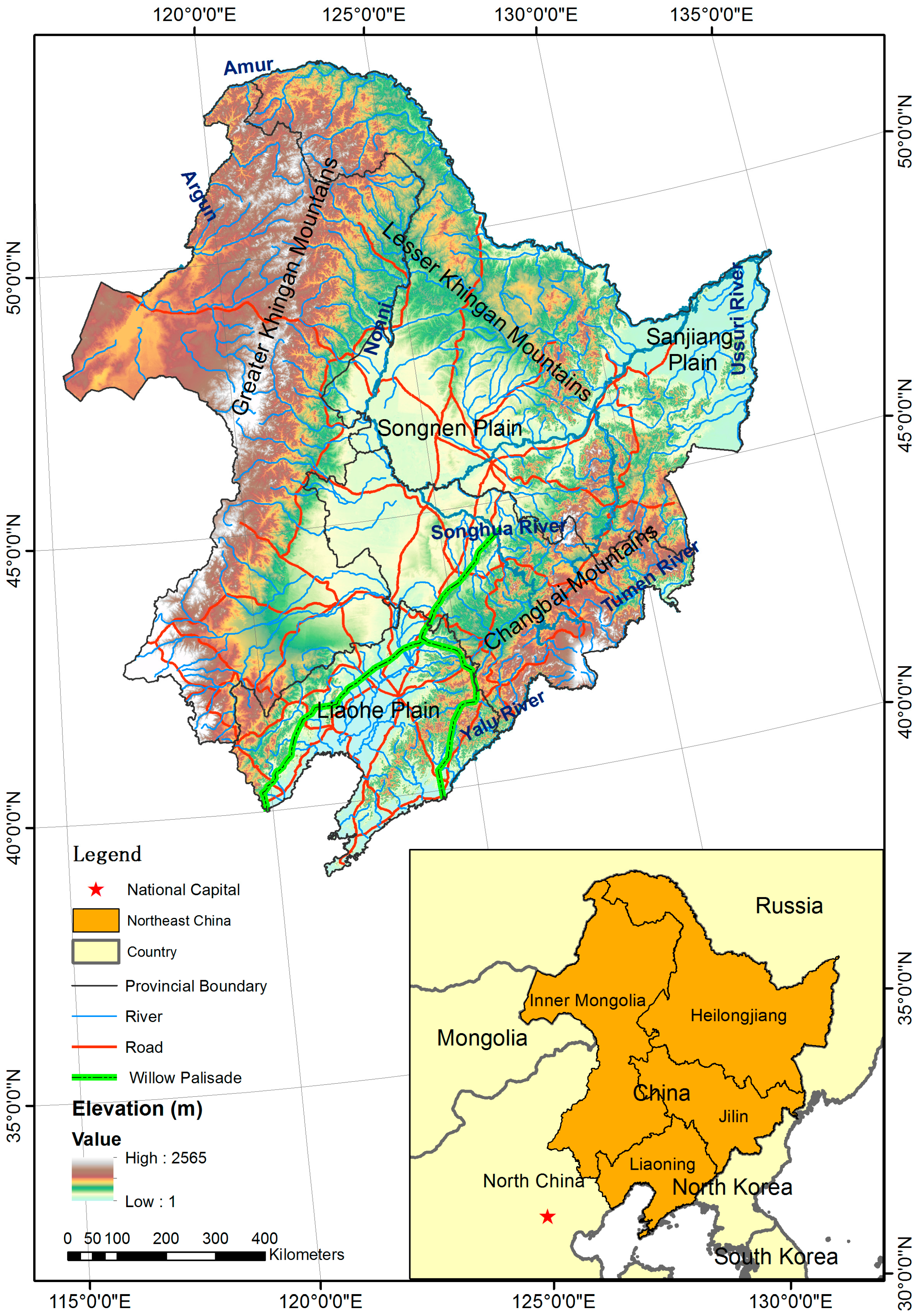
In English, Northeast China has historically been known as Manchuria. It is located in the northeastern region of the People’s Republic of China (Figure 1). It encompasses the three provinces of Liaoning, Jilin and Heilongjiang, which are collectively referred to as the Three Northeast Provinces. Northeast China also includes the eastern part of Inner Mongolia, specifically, the Hulunbuir, Hinggan, Tongliao and Chifeng divisions, which approximately correspond to areas that have been historically and collectively referred to as the “Manchurian range.”
Northeast China is located in the center of Northeast Asia. It is separated from Russia by the bordering Amur (Heilongjiang River), Argun and Ussuri Rivers. Neighboring North Korea is bounded by the Yalu River and the Tumen River. Mongolia, which is to the west of the Inner Mongolian Autonomous Region, is bounded by the Argun. The cradle of native ethnic minorities in Northeast China is situated next to rivers such as the Amur, Songhua and Nonni (Nen) Rivers [37]. Northeast China is next to North China, where the capital of China is located, with similar climate conditions. The northern part of Northeast China includes the Greater Khingan Mountains and the Lesser Khingan Mountains, and the southern part includes the Changbai Mountains that trend in the northeast-southwest direction. The heartland that is surrounded by these mountains includes the Sanjiang, Songnen and Liaohe Plains, which are collectively termed the Northeast China Plain.
2.2. Manchu
The Manchu are the largest group of Tungusic peoples. They number approximately 10 million and are the second-largest minority nationality in China according to the National Bureau of Statistics of the People’s Republic of China [38]. The Manchu are the direct descendants of the Jurchen, who were originally from Northeast China [39]. Following their conquest of China in the 17th century, the Manchu people became the dominant nationality [6]. The Eight Banners were the special organizational framework of Manchu in the Qing Dynasty [40]. The bannermen who belonged to the Eight Banners were the main members of Manchu [41]. Manchus in the Qing Dynasty were considered to be an ethnic community that included the descendants of the Manchu bannermen, along with many Manchu-assimilated Chinese and Mongolian bannermen [40]. Although the Manchu, Mongol and Han were the three principal groups of bannermen as Manchus during the Qing Dynasty [41], they are presently three independent ethnic groups. Thus, we analyzed the Han and Mongols in addition to the Manchu as the principal relevant ethnic groups.
The Tungusic languages (also known as Manchu-Tungus and Tungus) in Northeast China include Manchu, Evenki (Ewenke), Hejen (Hezhe), Orochen (Elunchun) and Xibe (Sibo) [2]. As the majority of the population in Northeast China, Han immigrants number more than one hundred million, whereas the number of remaining natives is less than ten million, and their native languages are almost endangered [2]. According to the Atlas of the World’s Languages in Danger [42], many native languages in Northeast China, such as Manchu, Manchurian Kirghiz, Dagur and Kilen (spoken by Hejen), are classified as critically endangered. Furthermore, Evenki and Manchurian Ölöt are defined as severely endangered. It is necessary to study both Manchu and related ethnic groups in Northeast China to explore the endangered Manchu language [43]. Because Manchurian Kirghiz and Manchurian Ölöt, who were transferred to Northeast China in the eighteenth century, are not natives [2], they are not considered in this study.
2.3. Toponyms
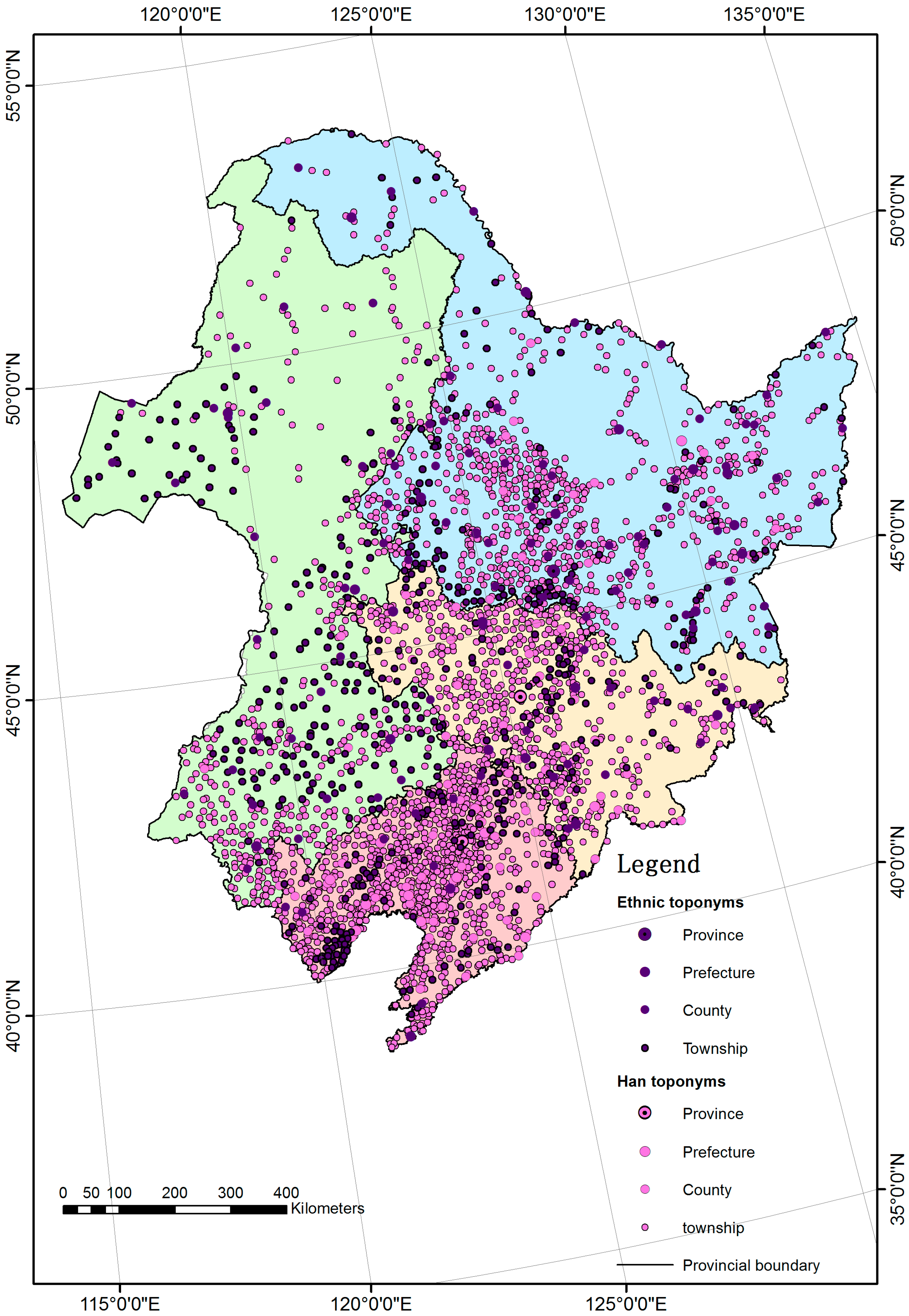
The place names of Northeast China that are used in this research were primarily collected and collated from Chinese dictionaries that explain the origin of toponyms [8,44]. We also referred to Manchu language resources [45] and Chinese Chorography in the local library [46]. The ethnic place names were recorded in Chinese in these resources, rather than in the original ethnic language, because of the absence of written language. Thus, the toponyms that originated from the ethnic language in Northeast China were changed to Chinese, as indicated by their pronunciation with a Han accent or their spelling in Chinese such that the original ethnic form is obscured. For the various translations of ethnolingustic toponyms, we analyzed ethnic place names using phonetic or literal translations based on current place names in Chinese rather than the generic terms [47] or properhood [48]. Moreover, the origins of place names at the city, county and township levels are well documented. There are few interpretations of village-level place names with respect to their origin from an ethnic or non-ethnic language, even though the number of villages in Northeast China is far more than in other levels. For example, the number of villages in the Jilin Province is 36,883. Thus, place names at the village level are not considered in this study.
Because ethnic autonomous counties and townships tend to be ethnic communities, it is assumed that their place names are also rooted in the local ethnic culture. This research considers such toponyms to be ethnic place names. The Manchu autonomous regions are dominated by the Manchu people but their toponyms less often originate from the Manchu language. This is because Northeast China’s Manchu autonomous regions, where, historically, more Han Chinese lived, were primarily established by Manchu immigrants during the Qing Dynasty [41]. The names of Manchu autonomous regions in Northeast China were primarily in Chinese. Thus, in this study, the Manchu toponyms are divided into toponyms that originated from the Manchu language and those that represent Manchu autonomous regions. The ethnic place names are collected in accordance with the current level of administrative statistics, as shown in Table 1. Because the small numbers of Xibe, Hejen and Hui prevent robust analysis, they are excluded from this study. The distributions of the collected toponyms are illustrated in Figure 2, where the light symbols represent Han toponyms and the dark symbols represent ethnic toponyms.
2.4. Environmental Factors
According to ethnic toponyms in Northeast China, we found that the natives used toponyms to represent extensive geographic knowledge, including flora, fauna and topography. The indigenous people in Northeast China preferred to describe the land cover (e.g., rivers and trees), because their original lifestyles were primitive fishing and hunting which were associated with the physical environments. In contrast, the names of Han settlements in Northeast China were influenced by their farming culture as immigrants. Because the spatial patterns of toponyms had relationships with the lifestyles of natives [28], this research analyzed related geographic data as influential factors. According to the lifestyles in Northeast China, we selected the trees, grass and crops to represent hunting, nomadism and farming as the indicators, respectively. We used data related to grass, trees and crops from the plant functional types map in China [49] and vegetative-type data from a Chinese vegetation map [50]. As the primary function of toponyms was to describe location information, a DEM (Digital Elevation Model) was selected as the topographical factor and roads were selected as the traffic factors [28]. The rivers were used as the influences of both transportation and the fishing lifestyle. We selected DEM, river and road data from the National Geomatics Center of China [51]. In Figure 1, the DEM data and the related river and road data reflect Northeast China’s topography and terrain. Because other environmental factors are less mentioned in ethnic toponyms, they will be considered in future work.
The birthplace of Manchu was around the Changbai Mountains and the Amur in Northeast China, which had rich natural resources for gathering, hunting and fishing [52]. The Qing government built the Willow Palisade to prevent the Han Chinese and the Mongols from entering this region, with the aim to protect the traditional Manchu culture and resources [40]. During the Qing Dynasty, the Willow Palisade divided the people of Northeast China into three areas: the Manchus in the East, the Mongols in the West and the Han Chinese in the South [52]. Moreover, because Northeast China was regarded as the home base of the Qing government, the Willow Palisade was also built to prohibit the migration of Han Chinese from North China into Northeast China until the end of the Qing Dynasty [40]. The Willow Palisade was associated with the distributions of ethnic toponyms as a historical factor. The Willow Palisade data are based on China Historical GIS [53], which are vector data based on the Historical Atlas of China [37].
2.5. Data Analysis
We regard place names as proxies of ethnic cultures and languages in Northeast China. However, merely mapping the toponyms directly, as in Figure 2, is of limited value. We can readily represent the characteristics of the spatial distributions of the ethnic toponyms by GIS and analyze whether the Sinicized place names with ethnic origins are related to the spatial distributions of the ethnic groups. One common method of measuring the trend for a set of points as toponyms is to calculate the x and y directions for the standard distance. This method can be used to define the standard deviational ellipse (directional distribution), which can be used to reflect the spatial characteristics of ethnic place names, such as their central tendency, dispersion and directional trends [27]. Comparing the size, shape and overlap of ellipses for various ethnic toponyms may provide insights into ethnic distribution trends.
We used the location of each ethnic toponym to represent the total number of ethnic people in the settlement. Since all the ethnic people in each settlement do not live at the point of the toponym, it is sensible to learn more about the spread of ethnic groups over the Northeast China. We create a surface showing the predicted distribution of each ethnic group throughout Northeast China by calculating the kernel density estimation (KDE), which is measured according to each location and spatial relationship of the ethnic toponyms [54]. The kernel density surfaces show the area where ethnic groups are concentrated, with a higher probability of ethnic activities in their native languages. We use the unified search radius, which is the height of Northeast China divided by 30, and each output raster cell size is 1000 × 1000 m. The population field is zero, as each toponym, which is counted once, has the same effect.
We display the distributions of environmental factors by KDE to calculate the correlations between toponyms and related influencing factors. The data for trees, grass and crops are obtained from the plant functional types map in China representing regular distributions of land cover by raster data [49]. The raster data cannot display the concentration region of each environmental factor by a continuous surface across Northeast China. We first convert the raster data into points. Second, we create the kernel densities of the converted points using the same method as for toponyms. The densities of rivers and roads as linear features can be calculated by KDE directly, whereas the DEM is a continuous surface without calculating KDE. Then, we calculate the correlations between the spatial pattern of toponyms and environmental factors using the Pearson correlation [55]. Although the low number of ethnic toponyms (Korean, Dagur, Evenki and Orochen) prevents analysis by KDE, we analyze the related ethnic groups in Northeast China by the proportions of vegetation and the distances to the nearest road that correspond to the locations of their toponyms.
3. Results and Discussion
3.1. The Geographic Distributions of Ethnic Groups by Toponyms
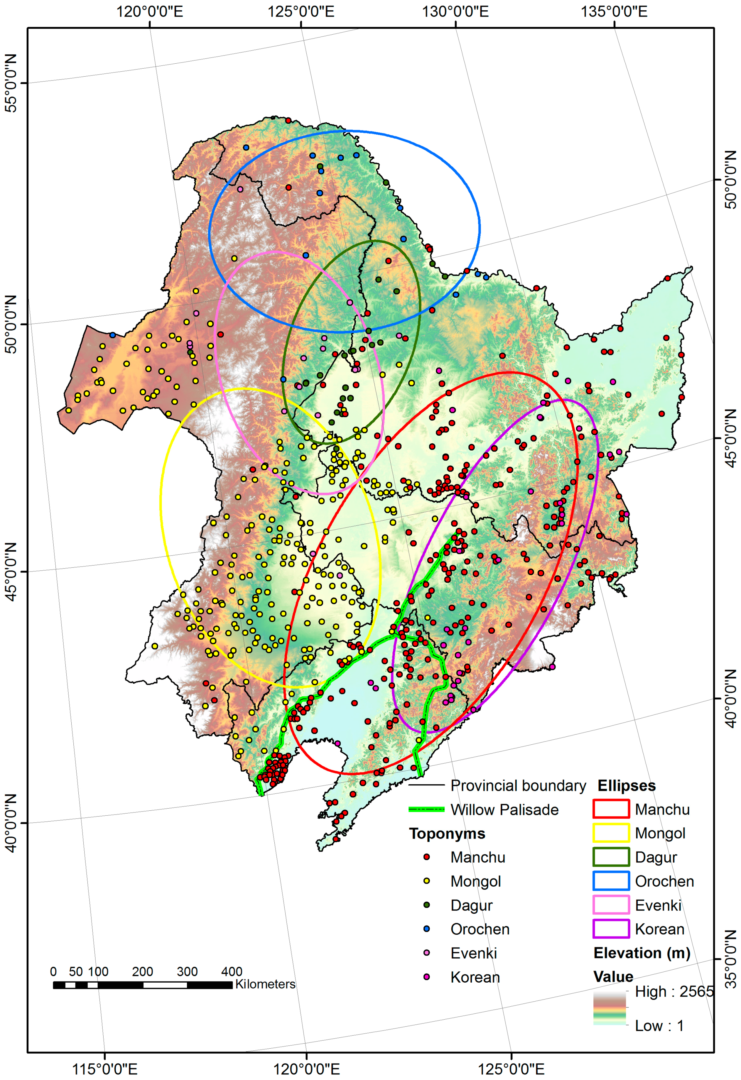
Northeast China is the homeland of many ethnic groups whose toponyms from ethnic languages have been recorded in Chinese. The geographic distributions of the ethnic original toponyms are represented by standard deviational ellipses in Figure 3. The distributions of Sinicized place names with ethnic origins are consistent with the spatial distributions of the ethnic groups in Northeast China and with the distribution of ethnic languages confirmed by the Geography of Nationalities in China [56]. In addition, these distributions offer insight into the lifestyles of the ethnic groups according to the geographical features of the locations.
The red ellipse displays the distribution of Manchu toponyms, whereas the yellow ellipse displays the distribution of Mongol toponyms. The Manchu place names are mainly located in the Three Northeast Provinces. Because there was a wealth of natural resources in the region in the Qing Dynasty, the traditional Manchu lifestyle was fishing and hunting, and many words in the Manchu language describe natural landscapes [6]. As a result, the traditional Manchu way was “Manchu language and archery on horseback,” which were protected by the Qing government [57]. In contrast, the Mongolians dwelled for a long time in the grasslands of Inner Mongolia, which is reflected by Mongol place names. Because their lifestyle can be described as continuously nomadic, the use of the Mongolic language by the Mongolians is a stable part of their lifestyle [56].
The Dagur, Orochen and Evenki were collectively referred to as the “Solon” in the Qing Dynasty, which means “the people who live upstream,” for their settlements were by the Nonni River [58]. The distribution of Orochen toponyms is indicated by the blue area in the north. There are two meanings of the term “Orochen” in the Orochen language. One refers to the training of a deer and the other refers to people who live in the mountains. The ellipse of the Dagur toponyms is represented by a region of dark green in the middle. “Dagur” refers to a “pioneer” in the Dagur language, reflecting that the Dagurs left the Middle Amur basin generations ago and moved to the Nonni basin in the middle of the 17th century [56]. The ellipse of the Evenki toponyms is represented in pink in the south; the Evenki name also means the “people who live in the mountains” in the Evenki language. The meanings of the three toponyms are related to the locations of their settlements, which are all located in the forest fringes of the Greater Khingan Mountains and near the Nonni River. Consequently, the languages of these three ethnic groups are related due to their similar economic and cultural characteristics, which included hunting and fishing based on their natural environment.
There are also place names that are derived from the Korean language. The settlements with these names were built by immigrants from North Korea during the late Qing Dynasty [56]. The ellipse of the Korean toponyms is in purple and centered along the North bank of the bordering Tumen River and Yalu River, both of which are crossed by the immigrants. Because the Koreans were not reliant on the environment as immigrants, they maintained their traditional way of farming culture and their native language.
3.2. Spatial Patterns of Manchu and Other Related Ethnic Toponyms
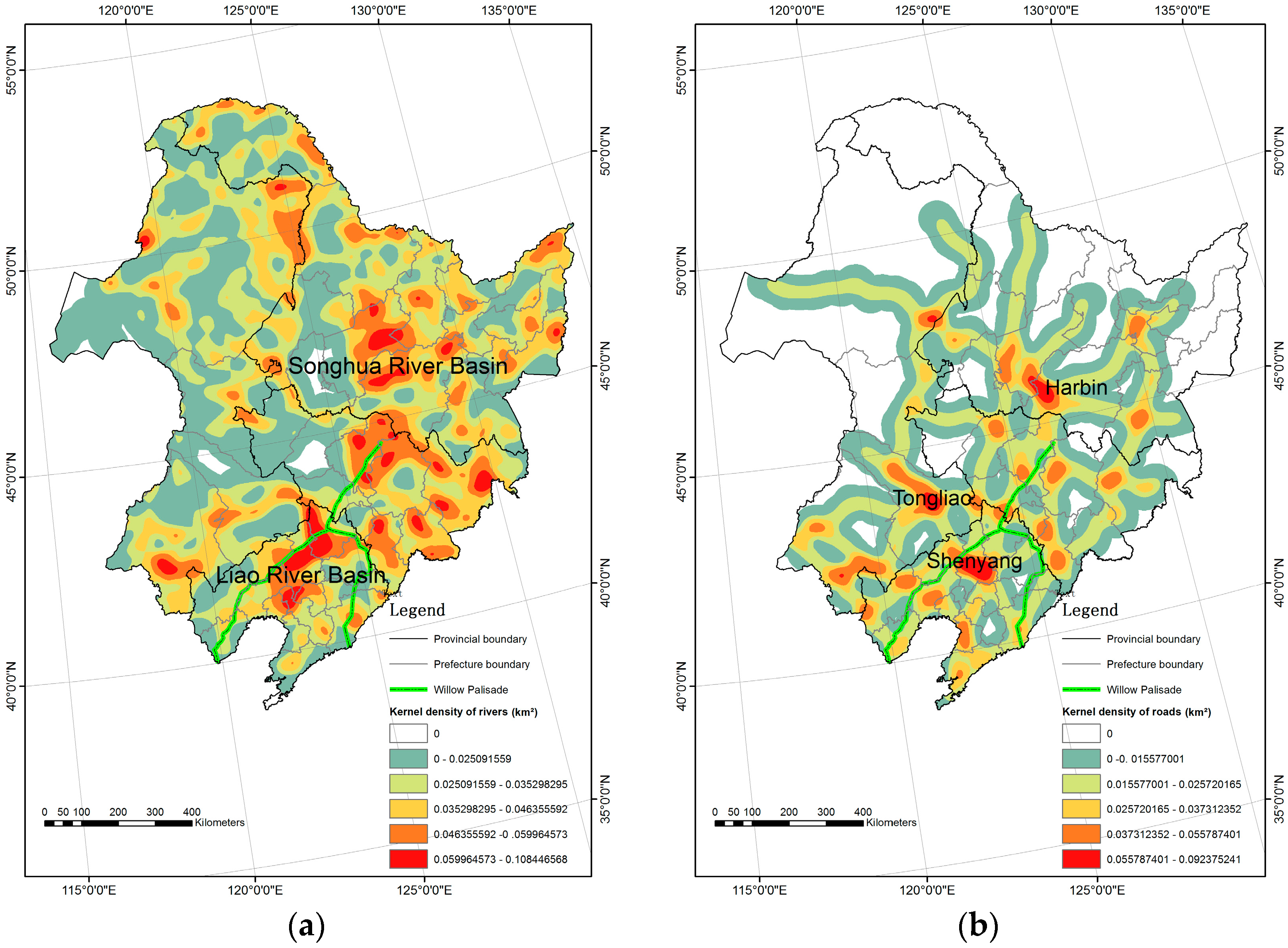
We found that the spatial distribution of place names with Manchu origins was within the Three Northeast Provinces. However, according to the National Bureau of Statistics of the People’s Republic of China [38], the Manchu population was primarily distributed within the Liaoning Province, rather than the Jilin and Heilongjiang Provinces. Our result is based on the analysis of both toponyms that originated from the Manchu language and those of Manchu autonomous regions, but the latter are primarily derived from the Chinese language. To analyze the evolution of Manchu in Northeast China, we analyze the two types of Manchu toponyms separately by KDE, which reveals the changes in the Manchu spatial distribution.
Because the toponyms reflect historical changes, the toponyms that originated from the Manchu language can be used to infer the distribution of Manchu people over time. As shown in Figure 4a, the high-density region is primarily distributed in the southeast of the Jilin Province and the south of the Heilongjiang Province based on modern administrative divisions. According to the Historical Atlas of China [37], this is the area where the Jurchen tribes lived before the Qing Dynasty. As the cradle of Manchu, this region is in the east of the Willow Palisade, which the Qing government prevented other ethnic groups from entering. Furthermore, the high-density areas of the toponyms were the major administrative centers, such as Ningguta and Jilin, which were established with the aim to protect Manchu traditional culture during the Qing Dynasty [37].
The toponyms of Manchu autonomous regions that are analyzed by KDE are shown in Figure 4b, which is primarily concentrated along the Willow Palisade. After the Nurhaci Emperor selected Mukden to be the capital of Later Jin as the early Qing Dynasty (AD 1625), known today as Shenyang in Liaoning Province, the bannermen, as army soldiers, migrated to the region and gradually settled in the townships as Manchu settlements [41]. However, before the Qing Dynasty, the settlements in the Liaoning Province were dominated by Han Chinese and the places were named in Chinese. The Han Chinese and Manchus in this area began to combine their cultures after the Manchu migration. To protect traditional Manchu culture in Manchuria, the Qing government established the Willow Palisade to prohibit the Han migrants from entering the region (AD 1638–1681) [52]. Thus, the bannermen chose to remain along the Willow Palisade, and a high density of Manchu autonomous regions was located around Shanhai Pass as a fortress between North China and Northeast China.
We analyze the toponyms of Han and Mongols in addition to the Manchu toponyms because Han and Mongols are the principal relevant ethnic groups. Figure 4c displays the distribution of the Han toponyms, which cover the major regions of the Northeast China Plain. Because the Willow Palisade was established to prohibit Han Chinese from entering the birthplace of Manchu until the end of the Qing Dynasty, the higher density regions of Han toponyms remain to the south of the Willow Palisade [52]. However, they now represent the overwhelming majority of the population in Northeast China whose ancestors emigrated from North China [59]. This immigration was called “Chuang Guandong,” literally translated as “venture into the east of the Pass” [60]. They selected the plains of Northeast China, which were similar to the North China Plain, for their settlements. Based on the spatial patterns of the Mongol toponyms in Figure 4d, the Mongolians currently remain to the west of the Willow Palisade, as there has been no change in their lifestyles and language.
The Manchus, who used to live to the east of the Willow Palisade, migrated to the region south of the Willow Palisade where more Han Chinese lived. Furthermore, with the increasing number of Han immigrants, the Han Chinese moved out from the limit of Willow Palisade and settled throughout the Northeast China Plain, constituting a large proportion of the population in Northeast China. As a result, there were more Han Chinese than Manchus in the regions where the ancestors of the Manchu lived before the Qing Dynasty. The change in spatial patterns revealed that the Manchu regions were occupied by the Han as the dominate people. It was inevitable for Manchu to interact with Han Chinese in Chinese instead of their indigenous language.
3.3. Environmental Factors Related to the Endangered Languages
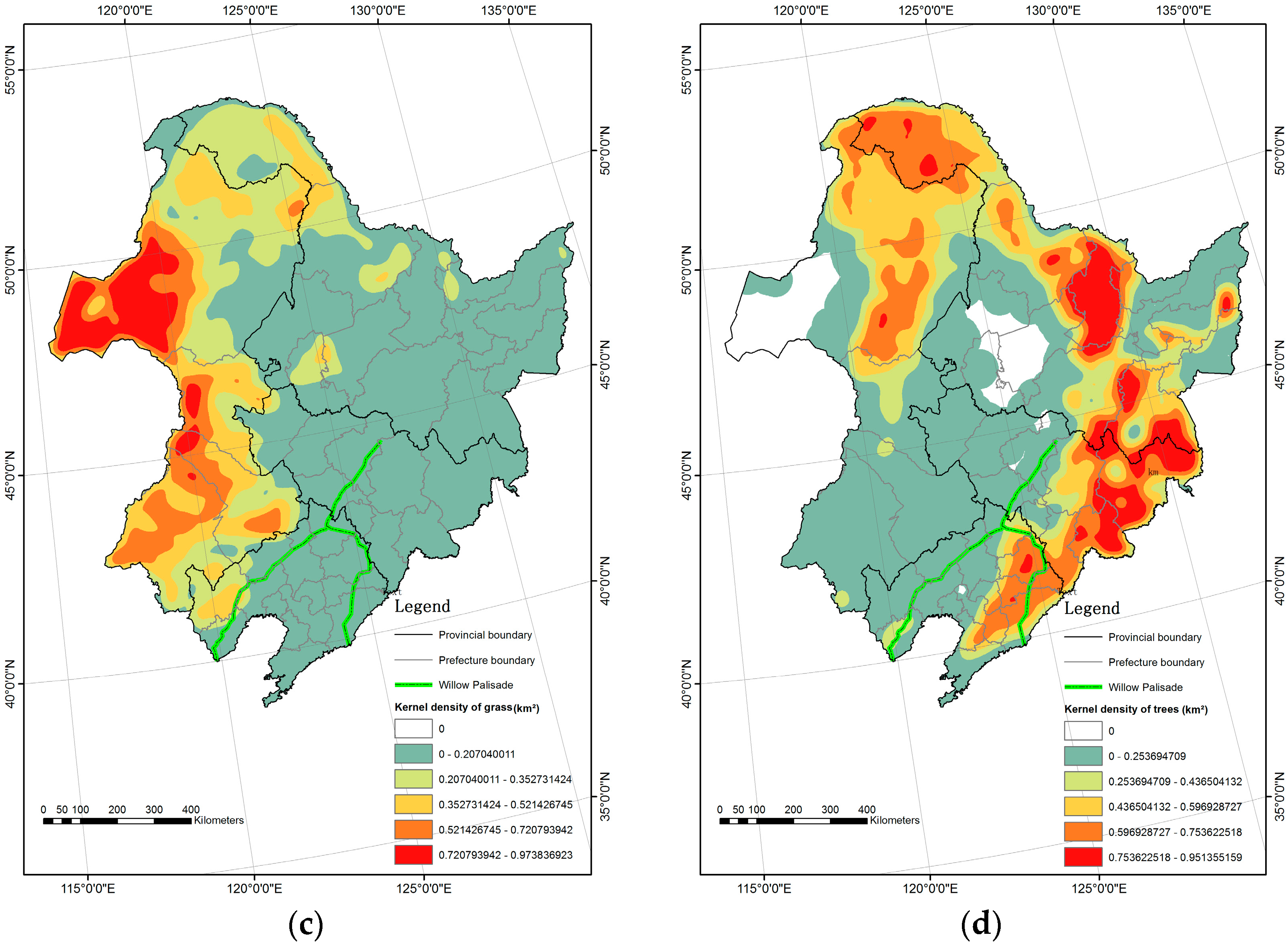
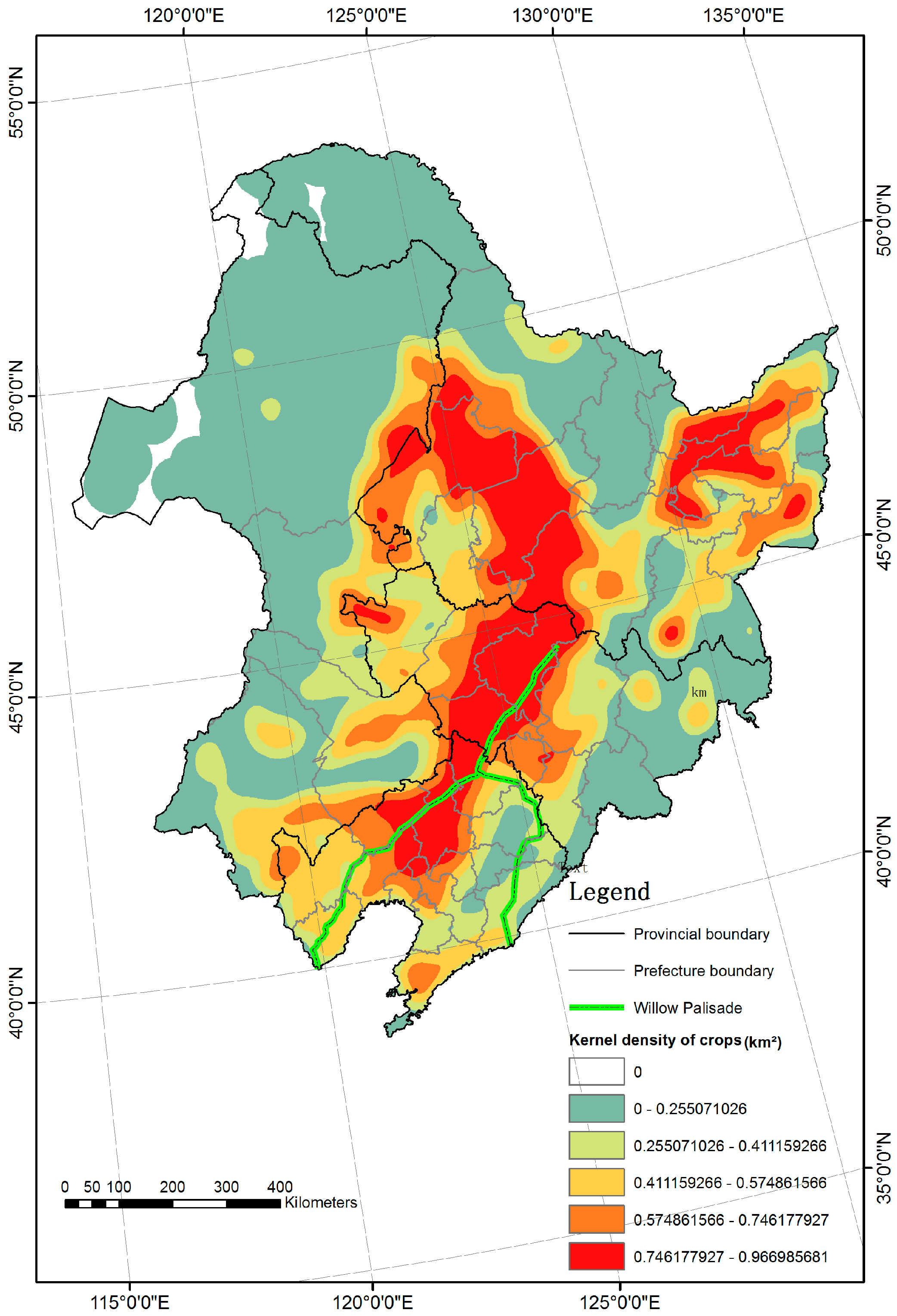
To investigate the relationships between the distributions of ethnic place names and environmental factors, we used KDE to display the distributions of rivers, roads, grass, trees and crops in Figure 5 and Figure 6, which are consistent with the actual situation. The higher-density river regions in Figure 5a are the Songhua River basin in the north and the Liao River basin in the south. According to the density map of major roads in Figure 5b, the cities in Northeast China are easily distinguished as hot clusters. For example, Shenyang and Harbin, which are both provincial capital cities in Northeast China, have the highest densities of roads, indicating convenient transportation. Another hot cluster in the west part of Northeast China is Tongliao, as the biggest city in the eastern part of Inner Mongolia. The highest-density area of grass, shown in Figure 5c, is in the northern part of the Great Khingan Mountains, primarily in the Inner Mongolia Province, where the main grasslands are located. The concentration areas of trees and shrubs, shown in Figure 5d, are distributed among the Great Khingan Mountains, the Lesser Khingan Mountains and the Changbai Mountains, which have been the main forest-resource regions in China. Farming areas are concentrated in the Northeast China Plain, which is the grain production base of China, as shown in Figure 6.
We statistically analyzed the associations between the spatial patterns of ethnic toponyms and those of environmental factors (DEM, rivers, roads, grass, trees and crops). According to the correlation coefficients in Table 2, the density of Han toponyms is moderately and negatively correlated with the DEM (−0.444), which indicates that in Northeast China, the number of Han Chinese decreases as elevation increases. However, Han toponyms are strongly and positively correlated with crops (0.680) and roads (0.555), which indicates that areas with more crops and roads have more Han Chinese whose main lifestyle is farming. Han toponyms are negatively correlated with grass (−0.408) and trees (−0.340), which indicates that Han Chinese are unlikely to reside in regions with grass and trees, which are not suitable for farming. The minimal relationship between Han Chinese and rivers (0.280) indicates that the group has little reliance on fishing as a lifestyle. Mongol toponyms have a negligible association with altitude (−0.064) because the Mongol people are nomadic and lack a fixed location. The correlation between Mongol toponyms and grass is moderately positive (0.422), whereas the correlation between Mongol toponyms and trees is negative (−0.444). There is little correlation between the density of Mongol toponyms and that of crops (0.008) or roads (0.071) and a slightly negative correlation between Mongol toponym density and river density (−0.200). These findings are consistent with the Mongols’ nomadic lifestyle, which is based on rangeland.
The results shown in Table 2 indicate that the toponyms that originate from the Manchu language have a negligible positive relationship with trees (0.011), whereas the toponyms of Manchu autonomous regions have a minimal negative association with trees (−0.055). However, crops (as the indicators of farming lifestyle) are positively correlated with the toponyms originating from Manchu language (0.347) and the toponyms of Manchu autonomous regions (0.183). The two types of Manchu toponyms both have weak negative correlations with the DEM and grass, and weak positive associations with roads and rivers. The distribution of environmental factors has little relevance to Manchu distribution due to land cover change caused by the overwhelming Han migrants as cropland was expanded and forests were diminished [61]. Because the densities of Han, Mongol and Manchu toponyms differ in the strength of their correlations with crops and roads, which were important factors for Han Chinese immigrants, we speculate that the vegetation and transportation patterns reflect the impact of the Han Chinese.
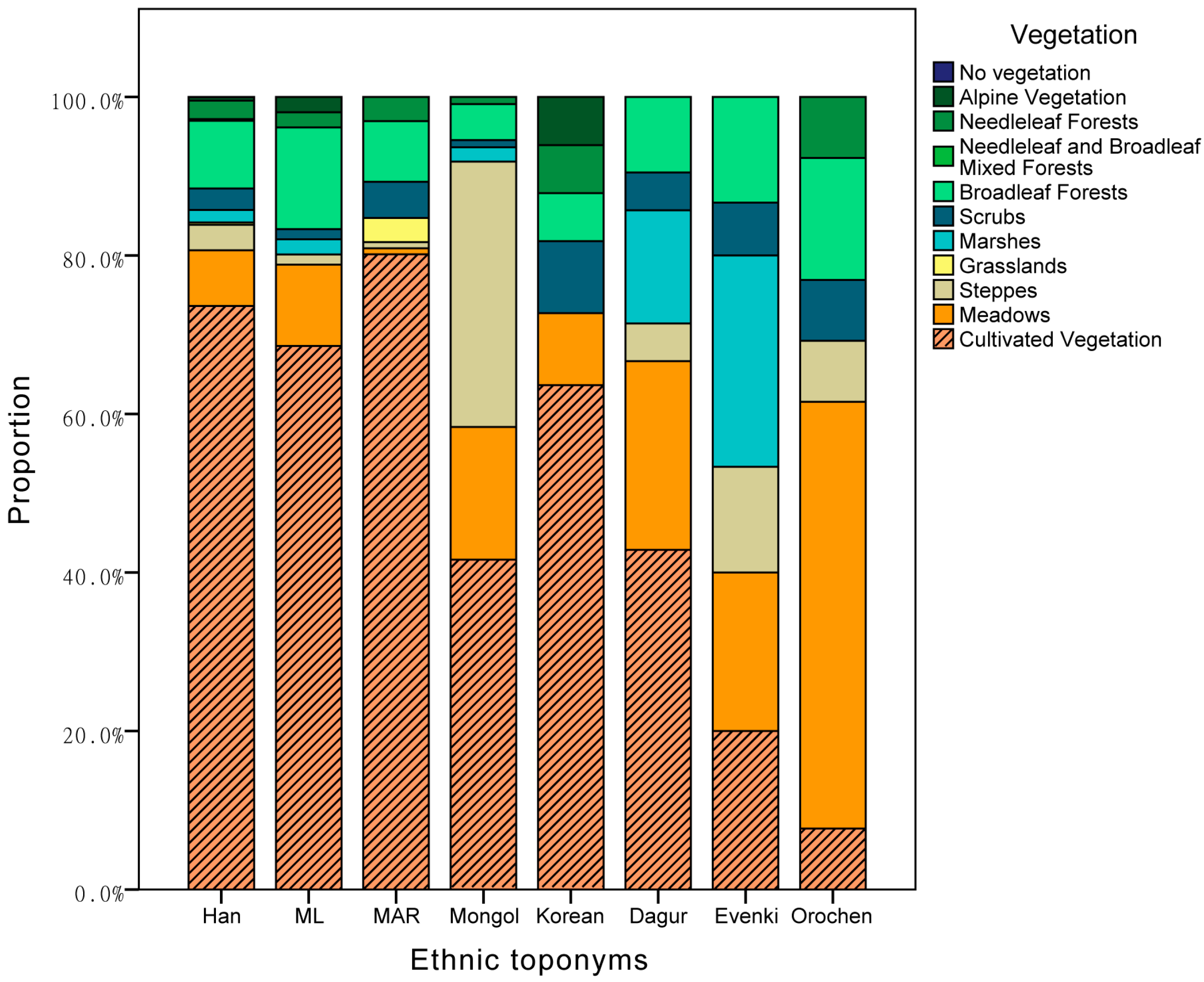
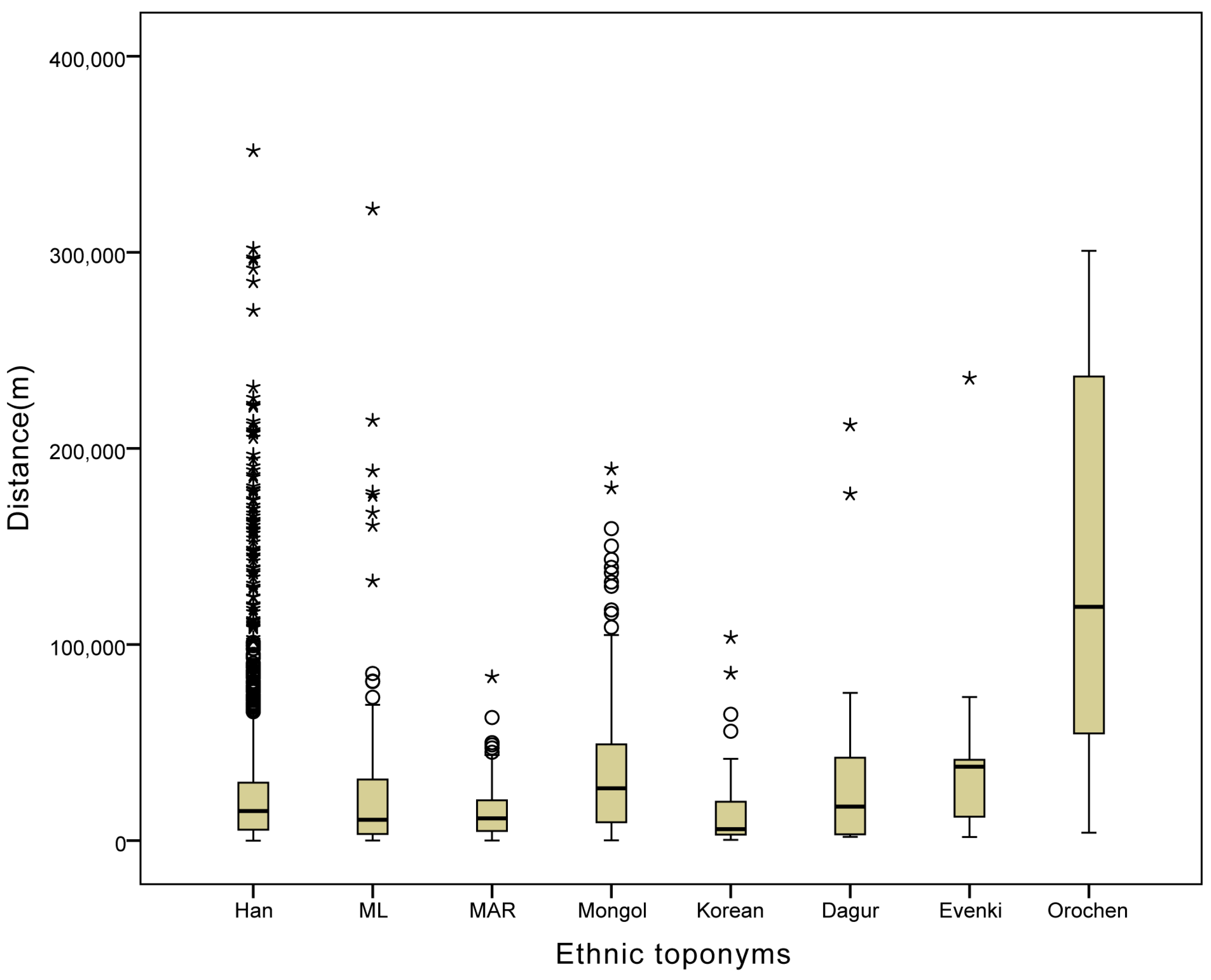
Based on the Chinese vegetation map [50], we analyze the proportion of vegetation cover in the locations of ethnic place names. As shown in Figure 7, the major vegetation corresponding to the locations of toponyms originating from the Manchu language, the Manchu autonomous regions, the Han and the Koreans is cultivated vegetation. Nearly half of the land cover of other ethnic groups in Northeast China, such as the Mongols and Dagur, is also cultivated vegetation. The main type of vegetation corresponding to the distribution Evenki and Orochen toponyms is natural vegetation. According to the distances between ethnic place names and the nearest road, indicated in Figure 8, the Mongol and Orochen toponyms are the most distant from the nearest road. The Han toponyms include many outliers due to the high number of toponyms relative to the other toponym types (Table 1).
The relationships among the patterns of toponyms and environmental factors were analyzed to explain how the Manchu language became endangered. Because the land cover of Northeast China has been natural vegetation for the past three hundred years [61], the original Manchu lifestyles primarily involved hunting and fishing, which the Manchu language was primarily based on. However, during the late Qing Dynasty, the Han Chinese came to Northeast China to farm, and this region become China’s main farmland. Because farming has been the main lifestyle of the Han Chinese over thousands of years of civilization, the change in land cover indicates that the region has been strongly affected by the Han culture. Based on the proportions of vegetation types in Figure 7, cultivated vegetation has been the main type of vegetation of Manchu, rather than natural vegetation. We speculated that the Manchu now view farming, rather than traditional fishing and hunting, as their main way of life. Because of the strong relationship between the means of production and the traditional culture [62], the original culture of Manchu was assimilated as the loss of traditional ways. Thus, the Manchu language was endangered with the acculturation and assimilation of Manchu in Northeast China. The language of the Manchu was a Tungusic language and included a large proportion of words for describing flora and fauna [63]. However, the Chinese language belongs to the Sino-Tibetan family, which is lack of linguistic relationship with the Manchu language [2]. The use of original words in the Manchu language is decreasing, but the use of Chinese loanwords is increasing, with the loss of biological diversity. Furthermore, the analysis of distance to the nearest road was consistent with the potential for Han Chinese migration, as it would not have been difficult for Han immigrants to travel to these regions. Because the major settlers in Northeast China were Han Chinese who spoke Chinese, the Manchu began to speak the dominant language, such that their native language became endangered [64].
The factors associated with the endangered status of the Manchu language in Northeast China are represented by crops as an indicator of farming culture and distance to the nearest road as an indicator of accessibility. As the native languages in Northeast China are also affected by the Han migrants, these considerations can apply to the other endangered languages in Northeast China. The Dagur language, which is primarily based on the hunting and fishing lifestyle similar to that of the Manchu, is classified as critically endangered, with increasing crops and convenient transportation. The Evenki and Orochen rely less on cultivated vegetation as an indicator of farming culture, but the Evenki language is severely endangered by the decreasing distance to the nearest road. The Mongol and Orochen have retained their original languages because the majority of the land cover in their regions remains natural vegetation and is far away from roads, suggesting that their primitive lifestyle is little affected by the Han Chinese. In addition, farming has long been the lifestyle of the Korean migrants without any change in their own language, similar to the Han Chinese.
Because natives increasingly prefer to speak Chinese as the official language in China, endangered languages, such as the Manchu language, should be paid attention as intangible cultural heritages. There are many other factors related to the endangered status of the Manchu language, such as education, policy, economic factors and marriage. More of the factors influencing the Manchu language will be taken into account in future studies to understand the association between environmental factors and toponyms. More statistical methods should be used in future investigations to understand the reasons for endangered languages in their social-historical context.
4. Conclusions
There are many ethnolinguistic origins of place names in Northeast China that are either pronounced with a Han accent or spelled in Chinese. By integrating spatial analysis measures, we demonstrate that the Sinification of ethnic toponyms can reflect the spatial distributions of ethnic groups and ethnic languages in Northeast China, both of which are related to the lifestyles of the ethnic groups.
The study shows the migration of Manchu from original living areas to the regions south of the Willow Palisade where more Han Chinese lived, reflected by the Manchu toponyms. The Han Chinese have been widely distributed throughout Northeast China, as reflected by the Han toponyms. The change in spatial distributions promotes the interaction between the Manchu and the Han Chinese. As the number of Han toponyms is greater than the others, most of the settlers in Northeast China are Chinese who speak the Chinese language. It is convenient for the Manchus to communicate with the Han Chinese in Chinese as a dominant language, rather than in the indigenous language.
We revealed that the lifestyle of the Manchu has changed to farming and that their settlements are near the roads, based on the relationships between toponyms and environmental factors. It has become easier for them to communicate with the Han Chinese and learn to plant crops instead of engaging in traditional activities such as fishing and hunting in this region. Because the Manchu language is a Tungusic language, there is a large proportion of words describing the natural environment that are related to the original lifestyle of the Manchu. With the loss of traditional ways of life, the use of original words in the Manchu language is decreasing and the use of Chinese loanwords is increasing. The Manchus prefer to speak the Chinese language for its expressive words, so their native language is becoming an endangered language.
Acknowledgments
This work was supported by the Fundamental Research Funds for the Central Universities (Grant No. 14ZZ2133), the National Natural Science Foundation of China (Grant Nos. 41771450, 41501449, 41571489, 41601438), the Fundamental Research Funds for the Central Universities (Grant No. 2412017FZ021) the National Key Research and Development Project (Grant No. 2016YFA0602301) and the Special Financial Grant from the China Postdoctoral Science Foundation (2017T100193).
Author Contributions
Zhenhua Zhu contributed to the geospatial data analysis and the writing of the paper. Hongyan Zhang took the lead on the design and the assessment. Jianjun Zhao, Xiaoyi Guo, Zhengxiang Zhang, Yanling Ding and Tao Xiong collected data and reviewed the manuscript.
Conflicts of Interest
The authors declare no conflict of interest.
References
- Hee, K.E. A rudimentary study on the identity of Manchu languages in Qing Dynasty-centered on the Jesuits’ resources and educational contents of the eight banners official study and government schools. J. Chin. Humanit. 2012, 52, 37–56. [Google Scholar]
- Moseley, C. (Ed.) Atlas of the World’s Languages in Danger, 3rd ed.; UNESCO Publishing: Paris, France, 2010. [Google Scholar]
- Choi, W.; You, H.J.; Kim, J. The documentation of endangered Altaic languages and the creation of a digital archive to safeguard linguistic diversity. Int. J. Intang. Herit. 2012, 7, 114–122. [Google Scholar]
- Guo, M. Discussion and analysis of the causes of Manchu endangerment. Manchu Stud. 2008, 2, 30–36. (In Chinese) [Google Scholar]
- Hu, Y. Endangered language—Manchu language. J. Dalian Nationalities Univ. 2006, 4, 54–57. (In Chinese) [Google Scholar]
- Zhao, A. Reasons for endangerment of Manchu and Hezhe Languages. Altai HAKPO 2009, 19, 45–56. [Google Scholar] [CrossRef]
- Huang, X. Manchu place names and Manchu culture. Mangchu Stud. 2000, 2, 52–56. (In Chinese) [Google Scholar]
- Niu, R. Chinese Place Names Original Dictionary; Minzu University of China Press: Beijing, China, 1999. (In Chinese) [Google Scholar]
- Tent, J. Approaches to research in toponymy. Names 2015, 63, 65–74. [Google Scholar] [CrossRef]
- Rose-Redwood, R.; Alderman, D.; Azaryahu, M. Geographies of toponymic inscription: New directions in critical place-name studies. Prog. Hum. Geogr. 2010, 34, 453–470. [Google Scholar] [CrossRef]
- Capra, G.F.; Ganga, A.; Buondonno, A.; Grilli, E.; Gaviano, C.; Vacca, S. Ethnopedology in the study of toponyms connected to the indigenous knowledge on soil resource. PLoS ONE 2015, 10, e0120240. [Google Scholar] [CrossRef] [PubMed]
- Shi, G.; Ren, F.; Du, Q.; Gao, N. Phytotoponyms, geographical features and vegetation coverage in Western Hubei, China. Entropy 2015, 17, 984–1006. [Google Scholar] [CrossRef]
- Tretter, E.M. The power of naming: The toponymic geographies of commemorated African-Americans. Prof. Geogr. 2011, 63, 34–54. [Google Scholar] [CrossRef]
- Fuchs, S. An integrated approach to Germanic place names in the American Midwest. Prof. Geogr. 2015, 67, 330–341. [Google Scholar] [CrossRef]
- Fuchs, S. History and heritage of two midwestern towns: A toponymic-material approach. J. Hist. Geogr. 2015, 48, 11–25. [Google Scholar] [CrossRef]
- Conedera, M.; Vassere, S.; Neff, C.; Meurer, M.; Krebs, P. Using toponymy to reconstruct past land use: A case study of “brüsáda” (burn) in southern Switzerland. J. Hist. Geogr. 2007, 33, 729–748. [Google Scholar] [CrossRef]
- Calvo-Iglesias, M.S.; DÍaz-Varela, R.A.; MÉndez-MartÍnez, G.; Fra-Paleo, U. Using place names for mapping the distribution of vanishing historical landscape features: The Agras Field System in Northwest Spain. Landsc. Res. 2012, 37, 501–517. [Google Scholar] [CrossRef]
- Tucci, M.; Ronza, R.W.; Giordano, A. Fragments from many pasts: Layering the toponymic tapestry of Milan. J. Hist. Geogr. 2011, 37, 370–384. [Google Scholar] [CrossRef]
- Luo, W.; Hartmann, J.F.; Wang, F. Terrain characteristics and Tai toponyms: A GIS analysis of Muang, Chiang and Viang. GeoJournal 2010, 75, 93–104. [Google Scholar] [CrossRef]
- Wu, X. The Manchu place name Hinggan and its semantic analysis. Manchu Stud. 2012, 2, 11–16. (In Chinese) [Google Scholar]
- Nie, Y.; Leng, X. Analysis of the naming methods of Manchu place names in the Liaohe River Basin. J. Jilin Norm. Univ. 2011, 5, 47–49. (In Chinese) [Google Scholar]
- Yang, Y.; Li, J. The cause study of Manchu place names around Yitong River in the literature before republic. J. Jilin Norm. Univ. 2011, 5, 50–53. (In Chinese) [Google Scholar]
- Luebbering, C.R.; Kolivras, K.N.; Prisley, S.P. Visualizing linguistic diversity through cartography and GIS. Prof. Geogr. 2013, 65, 580–593. [Google Scholar] [CrossRef]
- Luo, W.; Hartmann, J.; Li, J.; Sysamouth, V. GIS mapping and analysis of Tai linguistic and settlement patterns in southern China. Geogr. Inform. Sci. 2000, 6, 129–136. [Google Scholar] [CrossRef]
- Borin, L.; Dannells, D.; Olsson, L.-J. Geographic visualization of place names in Swedish literary texts. Literary Linguist. Comput. 2014, 29, 400–404. [Google Scholar] [CrossRef]
- Qian, S.; Kang, M.; Weng, M. Toponym mapping: A case for distribution of ethnic groups and landscape features in Guangdong, China. J. Maps 2016, 12, 1–5. [Google Scholar] [CrossRef]
- Wang, F.; Zhang, L.; Zhang, G.; Zhang, H. Mapping and spatial analysis of multiethnic toponyms in Yunnan, China. Cartogr. Geogr. Inform. Sci. 2014, 41, 86–99. [Google Scholar] [CrossRef]
- Wang, F.; Wang, G.; Hartmann, J.; Luo, W. Sinification of Zhuang place names in Guangxi, China: A GIS-based spatial analysis approach. Trans. Inst. Br. Geogr. 2012, 37, 317–333. [Google Scholar] [CrossRef]
- Paik, C.; Shawa, T.W. Altitude and adaptation: A study of geography and ethnic division. Appl. Geogr. 2013, 40, 212–221. [Google Scholar] [CrossRef]
- Harmon, D. Losing species, losing languages: Connections between biological and linguistic diversity. Southwest. J. Linguist. 1996, 15, 89–108. [Google Scholar]
- Maffi, L. Linguistic, cultural, and biological diversity. Annu. Rev. Anthropol. 2005, 34, 599–617. [Google Scholar] [CrossRef]
- Fagúndez, J.; Izco, J. Spatial analysis of heath toponymy in relation to present-day heathland distribution. Int. J. Geogr. Inform. Sci. 2016, 30, 51–60. [Google Scholar] [CrossRef]
- Burenhult, N.; Levinson, S.C. Language and landscape: A cross-linguistic perspective. Lang. Sci. 2008, 30, 135–150. [Google Scholar] [CrossRef]
- Fagúndez, J.; Izco, J. Diversity patterns of plant place names reveal connections with environmental and social factors. Appl. Geogr. 2016, 74, 23–29. [Google Scholar] [CrossRef]
- Axelsen, J.B.; Manrubia, S. River density and landscape roughness are universal determinants of linguistic diversity. Proc. R. Soc. B Biol. Sci. 2014, 281, 20133029. [Google Scholar] [CrossRef] [PubMed]
- Lee, S.; Hasegawa, T. Evolution of the Ainu language in space and time. PLoS ONE 2013, 8, e62243. [Google Scholar] [CrossRef] [PubMed]
- Tan, Q. Historical Atlas of China; China Cartographic Publishing House: Beijing, China, 1996. (In Chinese) [Google Scholar]
- National Bureau of Statistics of the People’s Republic of China. Tabulation on the 2010 Population Census of the Peoples Republic of China; China Statistics Press: Beijing, China, 2012. (In Chinese)
- Shan, L. Remote homeland, recovered borderland: Manchus, Manchoukuo, and Manchuria, 1907–1985. Asian Stud. Rev. 2015, 39, 327–328. [Google Scholar] [CrossRef]
- Huang, P. Reorienting the Manchus: A Study of Sinicization 1583–1795; Cornell University, East Asia Program: Ithaca, NY, USA, 2011. [Google Scholar]
- Elliott, M.C. The Manchu Way: The Eight Banners and Ethnic Identity in Late Imperial China; Stanford University Press: Stanford, CA, USA, 2001. [Google Scholar]
- UNESCO. Atlas of the World’s Languages in Danger. 2010. Available online: http://www.unesco.org/ languages-atlas/ (accessed on 11 January 2018).
- Whaley, L.J. Some ways to endanger an endangered language project. Lang. Educ. 2011, 25, 339–348. [Google Scholar] [CrossRef]
- Yang, X. The Etymology of Place Names in the Northeast; Heilongjiang People’s Publishing House: Harbin, China, 1998. (In Chinese) [Google Scholar]
- Ning, C. Manchu language resources in the People’s Republic of China: A comprehensive review. China Rev. Int. 2009, 16, 308–322. [Google Scholar]
- Changchun Library. Evolution and Origins of the Place Names in the Northeast Cities. 2016. Available online: http://xuexi.ccelib.cn/sjk/diming/diming.htm (accessed on 11 January 2018).
- Derungs, C.; Wartmann, F.; Purves, R.S.; Mark, D.M. The meanings of the generic parts of toponyms: Use and limitations of gazetteers in studies of landscape terms. In Spatial Information Theory; Lecture Notes in Computer Science; Springer: Cham, Switzerland, 2013; pp. 261–278. [Google Scholar]
- Coates, R. Properhood. Language 2006, 82, 356–382. [Google Scholar] [CrossRef]
- Ran, Y.; Li, X. Plant Functional Types Map in China. Cold and Arid Regions Science Data Center at Lanzhou. 2011. Available online: http://westdc.westgis.ac.cn/ (accessed on 11 January 2018).
- Zhang, X.S.; Sun, S.; Yong, S.; Zhou, Z.; Wang, R. Vegetation Map of the People’s Republic of China (1:1,000,000); Geological Publishing House: Beijing, China, 2007. (In Chinese) [Google Scholar]
- National Geomatics Center of China. National Administration of Surveying, Mapping and Geoinformation. 2016. Available online: http://www.ngcc.cn/ (accessed on 11 January 2018).
- Edmonds, R.L. The willow palisade. Ann. Assoc. Am. Geogr. 1979, 69, 599–621. [Google Scholar] [CrossRef]
- CHGIS, Version 5. Fairbank Center for Chinese Studies and the Institute for Chinese Historical Geography at Fudan University. 2012. Available online: https://sites.fas.harvard.edu/~chgis/ (accessed on 11 January 2018).
- Wang, F. Quantitative Methods and Applications in GIS; CRC Press: Boca Raton, FL, USA, 2006. [Google Scholar]
- Zhang, Z.; Zhang, H.; Li, D.; Xu, J.; Zhou, D. Spatial distribution pattern of human-caused fires in Hulunbeir grassland. Acta Ecol. Sin. 2013, 33, 2023–2031. [Google Scholar] [CrossRef]
- Pan, Y.; Yi, J.; Sun, J. Geography of Nationalities in China; Science Press: Beijing, China, 2014. (In Chinese) [Google Scholar]
- Chang, M.G. A Court on Horseback: Imperial Touring and Construction of Qing Rule; Harvard University: Cambridge, MA, USA, 2007; pp. 1680–1785. [Google Scholar]
- Jiang, W. The Ethnic History in Northeast China; Jilin Literature and History Press: Changchun, China, 2014. (In Chinese) [Google Scholar]
- Yang, X. Series of Chinese Ethnic History in past Dynasties—The Ethnic History of Qing Dynasty; Social Sciences Academic Press: Beijing, China, 2007. (In Chinese) [Google Scholar]
- Miller, F.P.; Vandome, A.F.; Mcbrewster, J. Chuang Guandong; Alphascript Publishing: Saarbrücken, Germany, 2010. [Google Scholar]
- Ye, Y.; Fang, X. Spatial pattern of land cover changes across Northeast China over the past 300 years. J. Hist. Geogr. 2011, 37, 408–417. [Google Scholar] [CrossRef]
- Jacques, P.; Jacques, J. Monocropping Cultures into Ruin: The Loss of Food Varieties and Cultural Diversity. Sustainability 2012, 4, 2970–2997. [Google Scholar] [CrossRef]
- Whaley, L. Manchu-Tungusic and culture change among Manchu-Tungusic peoples. In Archaeology, Language and History; Terrell, J.E., Ed.; Bergin & Garvey Publishers, Inc.: South Hadley, MA, USA, 2001; pp. 103–124. [Google Scholar]
- Guo, M.; Yin, T. A tentative study on the practical changes of the oral Manchu in Sanjiazi Village. Altai HAKPO 2007, 17, 1–21. [Google Scholar]
Figure 1.
Location and geographic factors of Northeast China.

Figure 2.
The distributions of ethnic and Han toponyms in Northeast China.

Figure 3.
Ellipses of toponym distributions in Northeast China.

Figure 4.
Kernel density maps (km2) of (a) toponyms originating from the Manchu language; (b) toponyms of Manchu autonomous regions; (c) Han toponyms; and (d) Mongol toponyms.
Figure 4.
Kernel density maps (km2) of (a) toponyms originating from the Manchu language; (b) toponyms of Manchu autonomous regions; (c) Han toponyms; and (d) Mongol toponyms.

Figure 5.
Kernel density maps of (a) rivers; (b) roads; (c) grass; and (d) trees.


Figure 6.
Kernel density map of crops in Northeast China.

Figure 7.
Proportions of vegetation types associated with ethnic place names. ML represents toponyms that originated from the Manchu language. MAR represents toponyms of Manchu autonomous regions.
Figure 7.
Proportions of vegetation types associated with ethnic place names. ML represents toponyms that originated from the Manchu language. MAR represents toponyms of Manchu autonomous regions.

Figure 8.
Distances between ethnic place names and the nearest road. ML represents toponyms that originated from the Manchu language. MAR represents toponyms of Manchu autonomous regions. o represents mild outliers. * represents extreme outliers.
Figure 8.
Distances between ethnic place names and the nearest road. ML represents toponyms that originated from the Manchu language. MAR represents toponyms of Manchu autonomous regions. o represents mild outliers. * represents extreme outliers.


Table 1.
Numbers of toponyms at various administrative levels in Northeast China.
| Ethnic Name | Province | Prefecture | County | Township | All |
|---|---|---|---|---|---|
| Han | 2 | 13 | 164 | 2403 | 2582 |
| Manchu | 1 | 15 | 68 | 208 | 292 |
| ML 1 | 1 | 15 | 61 | 85 | 162 |
| MAR 2 | 0 | 0 | 7 | 123 | 130 |
| Mongol | 0 | 7 | 31 | 214 | 252 |
| Korean | 0 | 0 | 1 | 32 | 33 |
| Dagur | 0 | 0 | 5 | 17 | 22 |
| Evenki | 0 | 1 | 2 | 14 | 17 |
| Orochen | 0 | 0 | 3 | 11 | 14 |
| Xibe | 0 | 0 | 0 | 6 | 6 |
| Hejen | 0 | 1 | 0 | 3 | 4 |
| Hui | 0 | 0 | 0 | 4 | 4 |
| Total 3 | 3 | 37 | 274 | 2912 | 3226 |
1 ML represents toponyms that originated from the Manchu language; 2 MAR represents toponyms of Manchu autonomous regions; 3 Total number of toponyms excluding ML and MAR.
Table 2.
Pearson correlation coefficients of the spatial distribution densities of ethnic toponyms and environmental factors.
Table 2.
Pearson correlation coefficients of the spatial distribution densities of ethnic toponyms and environmental factors.
| Rivers | Roads | Grass | Trees | Crops | DEM | ||
|---|---|---|---|---|---|---|---|
| Han | Pearson Correlation | 0.280 ** | 0.555 ** | −0.408 ** | −0.340 ** | 0.680 ** | −0.444 ** |
| Sig. (2-tailed) | 0.000 | 0.000 | 0.000 | 0.000 | 0.000 | 0.000 | |
| N | 1,232,272 | 1,232,272 | 1,232,272 | 1,232,272 | 1,232,272 | 1,232,272 | |
| ML 1 | Pearson Correlation | 0.268 ** | 0.294 ** | −0.372 ** | 0.011 ** | 0.347 ** | −0.226 ** |
| Sig. (2-tailed) | 0.000 | 0.000 | 0.000 | 0.000 | 0.000 | 0.000 | |
| N | 1,232,272 | 1,232,272 | 1,232,272 | 1,232,272 | 1,232,272 | 1,232,272 | |
| MAR 2 | Pearson Correlation | 0.059 ** | 0.219 ** | −0.156 ** | −0.055 ** | 0.183 ** | −0.189 ** |
| Sig. (2-tailed) | 0.000 | 0.000 | 0.000 | 0.000 | 0.000 | 0.000 | |
| N | 1,232,272 | 1,232,272 | 1,232,272 | 1,232,272 | 1,232,272 | 1,232,272 | |
| Mongol | Pearson Correlation | −0.200 ** | 0.071 ** | 0.422 ** | −0.444 ** | 0.008 ** | −0.064 ** |
| Sig. (2-tailed) | 0.000 | 0.000 | 0.000 | 0.000 | 0.000 | 0.000 | |
| N | 1,232,272 | 1,232,272 | 1,232,272 | 1,232,272 | 1,232,272 | 1,232,272 | |
** Correlation is significant at the 0.01 level (2-tailed); 1 ML represents toponyms that originated from the Manchu language; 2 MAR represents toponyms of Manchu autonomous regions.
© 2018 by the authors. Licensee MDPI, Basel, Switzerland. This article is an open access article distributed under the terms and conditions of the Creative Commons Attribution (CC BY) license (http://creativecommons.org/licenses/by/4.0/).
Share and Cite
MDPI and ACS Style
Zhu, Z.; Zhang, H.; Zhao, J.; Guo, X.; Zhang, Z.; Ding, Y.; Xiong, T. Using Toponyms to Analyze the Endangered Manchu Language in Northeast China. Sustainability 2018, 10, 563. https://doi.org/10.3390/su10020563
AMA Style
Zhu Z, Zhang H, Zhao J, Guo X, Zhang Z, Ding Y, Xiong T. Using Toponyms to Analyze the Endangered Manchu Language in Northeast China. Sustainability. 2018; 10(2):563. https://doi.org/10.3390/su10020563
Chicago/Turabian StyleZhu, Zhenhua, Hongyan Zhang, Jianjun Zhao, Xiaoyi Guo, Zhengxiang Zhang, Yanling Ding, and Tao Xiong. 2018. "Using Toponyms to Analyze the Endangered Manchu Language in Northeast China" Sustainability 10, no. 2: 563. https://doi.org/10.3390/su10020563
Note that from the first issue of 2016, this journal uses article numbers instead of page numbers. See further details here.